Abstract
Nikolaos Sophianos's Totius Graeciae Descriptio, an early regional map of Greece, was a cartographical bestseller of the late sixteenth century. The first editions of the map (1540, 1544, 1545) were hitherto believed to be lost, and contemporary references are few. Such references as could be found were collected and published by Émile CitationLegrand in 1885, and his data, enhanced by information derived from later reissues of the map (1552 and 1601), provided the foundation for recent bibliographical entries. This material has now been supplemented by recently rediscovered examples of the 1545 edition of Sophianos's map. By combining the new evidence with the material accompanying the various editions of the map (geographical introductions, indexes and gazetteers), it has proved possible to reconstruct the map's publishing history, to analyse its content and to investigate certain issues related to the methodology, uses and functions of early modern antiquarian cartography of Greece.
Dr George Tolias is Research Director, Institute for Neohellenic Research, The National Hellenic Research Foundation.
A number of studies in recent years have shown that learned humanistic and antiquarian motives underlay map‐making activities and the way maps were used in the early modern era. The research has shed light on the growing interest of humanists in ancient geography and cartography and, especially, on their thorough efforts to visualize and tabulate the geographical reality of the past and to evaluate its relation to the modern world.Footnote1 A significant step in the context of sixteenth‐century antiquarian geographical curiosity is the large map of Greece first published by Nikolaos Sophianos in Rome in 1540.
Sophianos's large map of Greece was both a product and an agent of the revival of Greek studies in the early sixteenth century.Footnote2 Its creation seems to have been in part the fruit of the author's patriotic and pedagogic concerns, but it was also an outcome of a universal spirit—fairly utopian in several aspects—that aimed to link the modern and the antique, Greece and Rome, Orthodoxy and Catholicism, even paganism and Christianity.Footnote3 The map presented an historical cartographical panorama of the Greek world and would thus have been understood as a major repository of antiquarian information about Greece. As a result, the work was well received by Hellenists and antiquarian scholars alike. It was reissued frequently, being copied and plagiarized, for some forty years after its initial publication, until it was finally standardized by inclusion in Ortelius's historical atlas, the Parergon, in 1579.
In the following pages we summarize Sophianos's ambition to regenerate Greek as a literary, sacred and living language before we attempt, in the light of the available evidence, to trace the history of the successive editions of his map. We shall then examine its content and its uses as a literary and antiquarian reading aid. Finally, we shall conclude with an evaluation of the underlying meaning of the work and its resulting functions, adding, in the Appendix, an updated carto‐bibliography.
Nikolaos Sophianos (c.1500–after 1551)
Nikolaos Sophianos was born into the local nobility of Corfu at the beginning of the sixteenth century.Footnote4 He was educated in Rome at the Quirinal College, an institution created by Pope Leo X—born Giovanni de' Medici (1475–1521)—a humanist and great patron of art and letters, and Janus Laskaris (1445–1534), the Byzantine émigré scholar, diplomat and patriotic activist.Footnote5 At the Quirinal College Sophianos studied under Greek scholars who were teaching there, such as Laskaris, Markos Mousouros, Zacharias Kalliergis and Arsenios Apostolis.
The Quirinal College illustrates a particular climate, at once Christian and humanistic, which reached its apogee in the pontificate of Leo X. The evidence suggests that the college was a product of the ecumenical spirit that prevailed after the Council of Ferrara‐Florence (1438–1439), at which it was agreed to reunite the Orthodox and Latin churches under the authority of the pope.Footnote6 The creation of the Vatican's Greek College established a Greek humanistic centre in Rome similar to Aldus Manutius's New Academy in Venice.Footnote7 At the same time the Quirinal College was intended to keep the Greek spirit alive in Ottoman‐dominated Greece by educating young Greeks who would eventually return to their homeland, and to boost the morale of the subjugated Greeks on whom the Vatican was counting to resist the invaders. The scheme was not entirely utopian given the recurrent Venetian and Spanish wars against the Turks and the frequency of papal appeals for a new Crusade.Footnote8 Unsurprisingly, the activities of Greek scholars teaching in the college were stamped with patriotic fervour: all were well known for the petitions, laments and exhortations they addressed to one and all in their efforts to persuade the spiritual and political leaders of the West to liberate the Christian populations of the East from Ottoman rule.Footnote9
More specifically, in relation to Sophianos's map, we should note that the activities of the Greek scholars in the Quirinal College had an antiquarian tone. Two undertakings in particular serve to illustrate their interest in Greek historical geography and monumental topography: Markos Mousouros's editio princeps of Pausanias's Description of Greece [Ελλάδος Π∊ριήγησις] with its ardent patriotic preface (Venice, Manutius, 1516), and Janus Laskaris's correction of the commentaries on Homer by Eustathios of Thessaloniki (d. c.1194), a long compilation rich in philological elucidations of a multitude of obscure points related to the mythological background and the topographical setting of the Homeric poems. Mousouros and Laskaris were driven to compile their works as a way of restoring the cultural, material and geographical realities of Greek antiquity. Both works had a strong influence on Sophianos's approach; he published Eustathios's Commentaries on Homer (Rome, Blado, 1542), and Pausanias's Description was one of the main sources of information for his map.
Sophianos did not return to live in Greece. With the exception of a journey there in 1543, he divided his time between Rome and Venice. After leaving the Quirinal College, he became a librarian in Rome.Footnote10 Between 1533 and 1540 he was settled in Venice where he worked as a copyist and a dealer in old Greek manuscripts. Of all the surviving manuscripts in Sophianos's hand, one is of particular interest since it reveals his early attraction to empirical scepticism, a philosophical trend that would become widely diffused in the late sixteenth century and thereafter. This manuscript, dated Venice 1534, is a copy of the third‐century Pyrrhonian Sketches [Πυρρών∊ι∊ς Υποτυπώσ∊ις] by Sextus Empiricus, which Sophianos presented to the French ambassador to Venice, Georges de Selve, Bishop of Lavaur.Footnote11 It was while he was in Venice that Sophianos first showed his interest in the living forms of the Greek language by compiling a grammar of vernacular Greek and creating a project for a huge dictionary of modern Greek.Footnote12 The grammar, dedicated to Jean de Guise, Cardinal of Lorraine from 1518 to 1550, was published by Émile CitationLegrand in 1870 (2nd edition 1874).
In 1540, Antonio Blado (1490–1567),Footnote13 the Vatican's official printer, invited Sophianos, by now renowned as a copyist of Greek manuscripts and a calligrapher, to Rome to design a Greek font for the new Greek press established in the Vatican by Cardinal Marcello Cervini (1501–1555).Footnote14 Cervini, who was in charge of the Vatican Library, aspired to create printed editions of Greek Christian and secular manuscripts held in the library. The Greek typeface designed by Sophianos was used for the first books produced on the press, Theophylactos of Ochrida's commentaries on the four Gospels and the first volume of the commentary on Homer by Eustathios, Archbishop of Thessaloniki.Footnote15 Sophianos's typeface, however, was almost immediately supplanted by a font designed by Giovanni Onorio.Footnote16
To demonstrate the new typeface to Pope Paul III for approval, Sophianos printed a sample leaflet and dedicated it to him. Paul III was notoriously superstitious and regularly consulted his favourite astrologer, Luca Gaurico, and this is probably why Sophianos chose a short essay in ancient Greek, which he had composed some years earlier, on the construction and use of the armillary astrolabe. He stressed that this instrument, which was widely used in astrology, navigation and cartography for the calculation of the positions of celestial bodies, was also ‘useful in horoscopy’.Footnote17 At some stage during his two years in Rome (1540–1542), Sophianos also printed his large map of Greece.
Sophianos left Rome in the middle of 1542, when his collaboration with the Vatican's Greek printing and publishing venture had come to an unhappy end.Footnote18 He returned to Venice where he initiated legal proceedings in what became a long drawn out court case against Blado over the ownership of his typeface and payment due to him for his work for the press.Footnote19 In Venice he reverted to dealing in Greek manuscripts. Among other activities, he purchased and made copies of Greek manuscripts for the Spanish bibliophile, Don Diego Hurtado de Mendoza, Charles V's ambassador to the Serenissima.Footnote20 From February to September 1543 he was in Greece as Mendoza's agent, spending most of his time in the monasteries of Thessaly and Mt. Athos, where he acquired a substantial number of manuscripts for his patron. Aubrey Diller has identified a manuscript in the University of Cambridge Library (Gg. II. 33) as a copy made by Sophianos from a manuscript in the Vatopedi monastery. Sophianos's copy includes mathematical and minor geographical treatises, such as Agathemerus's Diagnosis and Hypotyposis, and the first lines of Dionysius Byzantius's navigation of the Bosporus.Footnote21
It is tempting to imagine that political and military motives underlay Sophianos's mission to Greece, since most envoys sent to the Ottoman Empire by Western diplomats, and especially by the Spanish, were expected to report back on the mood of the people under Ottoman rule and on the military situation in those areas. No trace of any such report from Sophianos to Mendoza or to the Spanish administration in Naples has been found, however.
On his return from Greece, Sophianos, in collaboration with the Greek patriot Antonios Eparchos, tried to set up a Greek press in Venice under the patronage of Cardinal Cervini.Footnote22 The cardinal refused to finance the venture, however, and Sophianos decided to start a printing and publishing business of his own, together with Antonios Eparchos's son, Nikolaos, and with financial backing from Markos Samariaris, a merchant from Zante. This short‐lived venture (1544–1545) was addressed to Greek readers and inspired by a combination of commercial and patriotic motives, mainly, though, the latter.Footnote23
That Sophianos was strongly patriotic is demonstrated in the foreword to his translation into modern Greek of the pseudo‐Plutarch's On the Education of Children (1545). In this essay, Sophianos explained that his aim was ‘to revitalize a pitiable nation and give it wings to fly from all its lack of education’. Sophianos was nothing if not a pragmatist, and he was aware that the desired ‘revitalization’ might not succeed. He went on to assure his readers that, should his efforts come to nothing, he would return ‘to philosophy itself, and to his beloved and familiar geometry’.Footnote24 We may conclude that Sophianos had kept a set of the Greek typeface that he had designed for the Vatican's Greek press, since he was using it for the books he printed in Venice in 1544 and 1545. Furthermore, the same font was used by other printers not only in Venice, but also in Florence and Rome right up to 1570, although it is unclear whether Sophianos himself was involved in any way in any of these ventures.Footnote25
Sophianos's publishing activities ceased after 1545. In April 1547, he was still in Venice, where he is recorded as having made a contribution to the Greek community.Footnote26 In 1551 his dispute with Antonio Blado was resolved. According to the terms of the settlement, Sophianos was awarded 125 gold ducats for the design of the Greek font and supplied with two volumes of the edition of Eustathios as payment for Blado's hire of his fonts, and a case containing Greek letters, punches and lead was to be returned to him in Venice through the Vatican's notary.Footnote27 We have no information on either the date or the place of Sophianos's death and can only assume that he died sometime after June 1551, before which date he had been corresponding with Philip Melanchthon, reformer and Hellenist. Footnote28
Sophianos's Map of Greece (1540–1601)
Lost Editions, Rome 1540 and Basel 1544
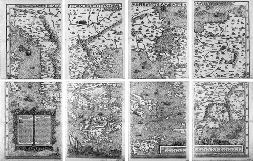
Sophianos's ‘beloved and familiar geometry’ bore a variety of fruit. Not only were there his commentaries on Ptolemy, his copy of minor Greek geographical treatises and his short essay in ancient Greek on the armillary astrolabe, but also—and, in the present context, above all—his large map of Greece, drawn and published during his residence in Rome in the years 1540 to 1542.Footnote29 The first edition of Sophianos's map has been lost, as was the case with many maps printed before it became common practice, in the last third of the sixteenth century, to bind the sheets together.Footnote30 Consequently, the map's publishing history has to be based on indirect literary allusions and on evidence inferred from surviving copies of later editions, especially those reissued first in Basel (1545) and then in Rome (1552)Footnote31 (Fig. and Appendix).
Figure 1 Stemma showing the descent of the main versions of Nikolaos Sophianos,Totius Graeciae Descriptio, during the period 1540–1602. The entries in italic are deduced. No copies are known to survive for the entries in square brackets.
The modern scholars Émile CitationLegrand and, following him, Robert CitationKarrow have both concluded from their examination of a letter addressed to Antonio Agustin by the antiquarian geographer Johannes Metellus, dated 8 February 1543, that Sophianos's map was already in existence, either in manuscript or in print, by this date.Footnote32 We can go further and affirm that it had already been printed, because, when Konrad CitationGesner wrote to Joachim Vadianus on 7 April 1543, he clearly described the map as printed.Footnote33 CitationGesner, furthermore, confirms the early existence of a printed map that he describes in his Bibliotheca universalis (1545) as ‘first published in Rome’.Footnote34 Whether the Rome map was a woodcut, like the extant reissue in 1545 of Johannes Oporin's Basel version, or a copperplate, like the edition printed in Rome in 1552, of which three exemplars survive, remains for the present, at least, uncertain.
Sophianos's colleague, the Hellenist Arnoldus Arlenius, who was in Mendoza's employ as librarian, had taken Sophianos's map to Basel sometime before April 1543.Footnote35 According to the letter addressed by CitationGesner to Vadianus, dated 7 April 1543, the map was supposed to have been issued by the Basel printer Oporin by the summer of that year.Footnote36 In the event, it is evident that Oporin's edition was not printed until 1544, since a copy of the newly printed map was sent by Oporin to Vadianus on 8 December 1544.Footnote37 The 1544 edition is furthermore confirmed by CitationGesner, who states in his Bibliotheca universalis that the map was printed in ‘the past year [that is, 1544] in Basel by Johannes Oporinus’.Footnote38 In the next year, 1545, Oporin reissued the map.
Hitherto, both Oporin's issues of 1544 and 1545 were considered lost. However, in 1975 Ernst Meyer discovered an example of the 1545 issue of the map in the National Library of Greece.Footnote39 Unfortunately, the map vanished soon afterwards. There is, however, another, albeit much mutilated, exemplar of the same issue in the Library of Congress. Although this has been there since 1958 and was recorded by Clara E. LeGear and Walter W. CitationRistow, the fragment has been ignored by all writing on Sophianos's map.Footnote40 Then, in 2004 a complete example of Oporin's 1545 reissue of Sophianos's map turned up for auction at CitationSotheby's, London.Footnote41 This map is identical to the mutilated American version and thus confirms the date of the latter as 1545.
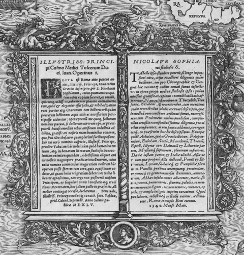
There is every reason to accept that the Basel issues of the map (1544 and 1545) followed the original Rome edition closely in the essentials. In the first place, the 1545 reissue carries a dedication from Oporin to Cosimo de' Medici, which confirms that the map was first published in Rome: ‘edita est Romae ante paucos annos’ [published in Rome a few years before]. In the second place, Sophianos's original address to the reader is dated ‘Rome at the temple of Bonus eventus, May 1540’ (Fig. ). Until now this has been considered to be the address and date when the map was drawn, not printed, since no other publication was known with this imprint.Footnote42
Figure 2 Sophianos's address to the reader from Rome ‘in templo Boni Eventus’, dated May 1540. Sophianos's original text was included in the later Basel issue of the map by Johannes Oporin (1545, see Fig. ). (Reproduced with permission from the Library of Congress, Washington, D.C., G 2000 1545 G 45 Vault.)
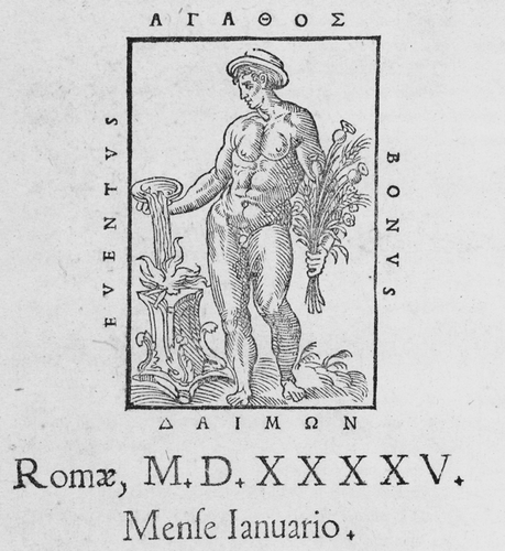
Nevertheless, the motto ‘Bonus eventus’, which refers to the minor Greek divinity Agathodaemon (‘Good Spirit’ or ‘Good Fortune’), was one of the marks used by Antonio Blado, the Vatican's official printer. It is also found in the editio princeps of the Greek text of Historical Miscellanies (Ποικίλη Ιστορία) by Claudius Aelian, printed in Rome by Blado in 1545, where the motto appears both on the title page and in the colophon.Footnote43 The motto is written in Latin and Greek (Bonus eventus / Αγαθός Δαίμων) and frames the effigy of an upright naked man who holds a bouquet of poppies while making a libation with a patera (a shallow dish) (Fig. ).
Figure 3 Antonio Blado's printer's device. From the editio princeps of Claudius Aelian's Ποικίλης Ιστορίας βιβλία ΙΔ′ (Variae Historiae libri XIIII, Rome, 1545). The motto Bonus Eventus / Agathos Daemon refers to a minor pagan divinity Agathodaemon (‘Good Spirit’ or ‘Good Fortune’). (Reproduced with permission from the Gennadius Library, The American School for Classical Studies, Athens, GC 2756.)
We are thus led to conclude that the first edition of Sophianos's map had been printed by Antonio Blado on the Vatican's newly established Greek press in May 1540. In these circumstances, we may assume that the allusion to Ptolemy that Sophianos made in the dedication of his leaflet on the armillary astrolabe to Pope Paul III was also an allusion to his own map of Greece.Footnote44 We could go further and venture that the original edition of Sophianos's map of Greece was also dedicated to the Pope Paul III, possibly even commissioned by him.
Blado was responsible for the printing of the map, but he would not have engraved it himself. Most probably he collaborated with a Roman engraver, as he later did for Leonardo Bufalini's large plan of Rome (1551), for which he type‐set only the short texts.Footnote45 The print run of the first edition of Sophianos's map must have been small indeed given the scarcity even of contemporary references to it, let alone the absence of surviving exemplars. Such an important work would not have passed unnoticed, however. The dispute between Sophianos and Blado, and the long legal process that Sophianos set in train against the Vatican's chief printer, may have meant that the printing equipment remained inactive in Rome, until the conclusion of the legal proceedings in 1551. The sequestration of the plates in Rome from 1542 to 1551 would explain the delay in the reissue of the first Roman edition of Sophianos's map, which occurred in 1552.
Sophianos accompanied his map with a table of concordance of ancient and modern place‐names. This document, a printed sheet without a date or place of publication, contains 276 ancient place‐names with their modern equivalents or variants (Fig. ). The modern appellations are mainly from contemporary portolan charts and the variants are drawn from classical and medieval sources. Latin variants came from such authors as Virgil and Livy, and Greek variants mainly from the Byzantine scholars Eustathios of Thessaloniki and Stephanus of Byzantium.Footnote46 The concordance table also includes places with unaltered names. This means that, since Sophianos gave every name in the table a cardinal number corresponding to the number printed on the map adjacent to the relevant place sign, every place listed in the concordance table could be located on the map, and every place found on the map accompanied by a number could be checked for change of name in the concordance table.Footnote47 It is likely that the table accompanied the map from its first edition. For one reason, the use of portolan charts as a source of place‐names is mentioned in Sophianos's original address to the reader and, for another, the fact that both old and new names are included in Sophianos's work corresponds to CitationGesner's description of it as bearing both ancient and modern place‐names. Footnote48
Figure 4 Extract from one of the oblong versions of Nikolaos Sophianos's alphabetically ordered Nomina antiqua et recentia, a letterpress table of ancient and modern place‐names compiled to accompany the map. The ancient name is followed by the modern name and its Latin or medieval variants. The number at the end of each entry identifies the place on the map (see, for example, Figs , and ). (Reproduced with permission from the Library of Congress, G 2000 1545 G 45 Vault.)
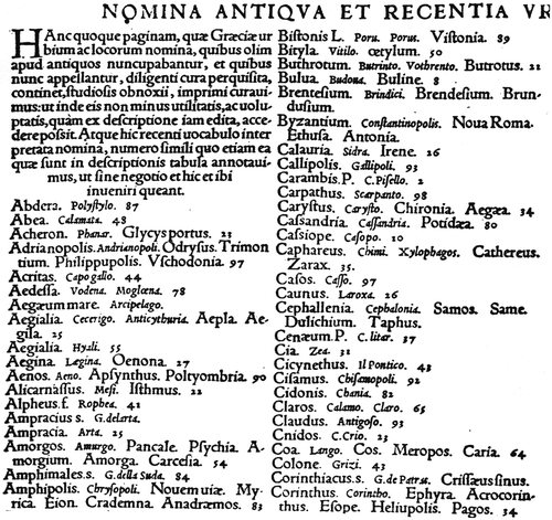
The concordance table exists in at least three different versions, two of them oblong and the other one more or less square. They are all printed and contain the same number of place‐names (276), although there are slight differences in the title and the introductory note. Two exemplars of the oblong version survive, each folded and bound in Gerbel's 1545 Praefatio.Footnote49 The unique extant example of the almost‐square version (in which the text is in five columns) is in Paris, bound into a manuscript volume.Footnote50 One copy of the oblong versions also contains four laudatory epigrams about Sophianos and his map composed by Leon Marsus, L. Faber Phan, Faustus Sabaeus and Faustinus Buturinus Veronensis.Footnote51 Since the four epigrams are also found on the later large editions of the map (Basel, Oporin, 1545; Rome, 1552), we may assume that the oblong version with the epigrams had originally accompanied the 1544 Basel edition. The oblong version without the epigrams was probably amended for the 1545 Basel edition, and the square version was prepared for the first or second Rome edition of the map (1540, 1552).
The First Basel Reissue (1545)
The map that Oporin reissued in Basel in 1545 is a woodcut measuring about 77×111.5 centimetres and printed on eight octavo sheets. It bears the title Descriptio Nova Totius Grœciœ per Nicolaum Sophianum (Fig. ). Prominent in the bottom left‐hand corner of the map, on sheet 5, is a large rectangular cartouche divided into two panels of text. The left panel contains Oporin's dedication of the map to Cosimo de' Medici; the right one contains a note from Sophianos to the reader (studiosis) in which, after some historical remarks concerning the ‘Chorography and Geography’ of Greece, Sophianos names his sources and explains the dotted boundary lines that indicate the provinces, regions and tribes—Punctis praeterea unamquamque provinciam, regions que, et gentes universas dirimentes, annotatimus. He then gives a list of other geographical features shown on the map. As already noted, this text ends with Antonio Blado's printer's statement—place of publication, motto and date—‘Romæ, in templo Boni eventus. 1540, Mense Maio’.
Figure 5 Nikolaos Sophianos,Descriptio Nova Totius Grœciœ. Reissue of the second edition, published in Basel by Johannes Oporin in 1545. Woodcut on 8 sheets, with an overall measurement of 77.3×111.4 cm. Oporin first issued the map in 1544. The example reproduced here surfaced in 2004 in London at a CitationSotheby's auction. (Reproduced with permission from CitationSotheby's.)
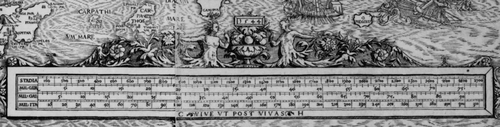
The 1545 reissue has Oporin's printer's mark—the figure of the legendary Corinthian musician Arion grasping his lyre as he rides on a dolphin—in the sea just above the cartouche, and the signature of the wood‐block cutter—CHS—with the date 1544 is on the sail of a boat north of the island of Crete. CHS is thought to indicate Master Christoph, that is, Christoph Schweicker of Strasbourg. The Strasbourg artist Heinrich Vogther the elder was responsible for the rich ornamentation of the map.Footnote52 The elaborate decoration of the cartouche is composed of curving acanthus leaves, various figures and faces and, at the bottom, in the centre, a medallion with a portrait (presently unidentified). The cartouche is balanced by a long scale bar in four different units (stadia and German, Gallic and Italian miles), in the right‐hand corner of the map. These units were worked out by the mathematician Christman Herlin of Strasbourg, who has signed the scale bar with his initials CH and given the date 1544 above the decoration (Fig. ).Footnote53
Figure 6 Nikolaos Sophianos,Descriptio Nova Totius Grœciœ, 1545 (see Fig. ). Detail showing the scale bar. The units of measurement are Greek stadia and German, Gallic and Italian miles. Along the bottom, on either side of the motto the initials CH are those of the Strasbourg mathematician Christman Herlin who compiled the scales for Oporin in 1544 (the date is given above the decoration). (Reproduced with permission from CitationSotheby's.)
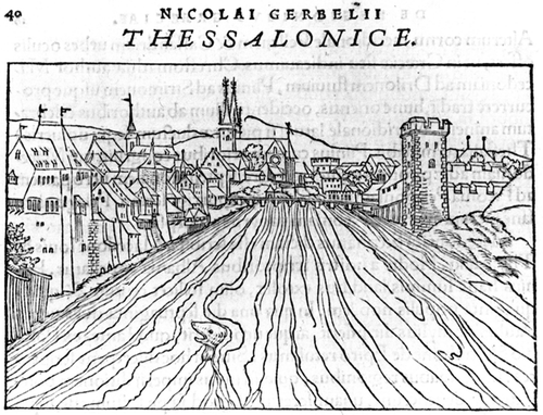
For the reissue in 1545, Oporin commissioned a Praefatio, or Introduction, from Nicolaus Gerbel (1485–1560), a Hellenist who was a pupil of Erasmus and friend of Philip Melanchthon and Martin Luther (Fig. ).Footnote54 The first few pages of this separate 90‐page folio volume are devoted to Gerbel's introductory remarks on the scholarly uses of the map. The substance of the booklet comprises a historical and geographical description of Greece, arranged in sections, each of which corresponds to an ancient Greek region or city. Most sections start with a woodcut view of the city or region in question, also cut by Master Christoph (Figs. and ).Footnote55 The views are imaginary, and some are reproductions or variants of older woodcuts of German towns here used for Greek towns; thus Thessaloniki (page 40) is represented by a view of Basel, Calydon (page 32) by a view of Munich, and Megalopolis (page 73) by a view of Zurich.Footnote56
Figure 7 Title page of the illustrated commentary, Nicolaus Gerbel's In descriptionem Graeciae Sophiani, praefatio (Basel, Johannes Oporin, 1545), which accompanied the reissue of Nikolaos Sophianos's map of Greece. Folio. 90 pp. (Reproduced with permission from the Gennadius Library, The American School for Classical Studies, Athens, GT 11.)
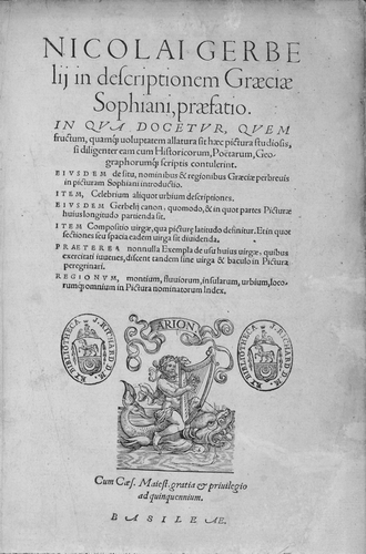
Figure 8 Nicolaus Gerbel's In descriptionem Graeciae Sophiani, praefatio (Basel, Johannes Oporin, 1545) contains 21 imaginary woodcut views of places marked on Nikolaos Sophianos's map of Greece. Although rather fanciful in their details, some of them bear some relation to reality. Thus Athens (on p. 19) is dominated by the Acropolis, Piraeus is shown with its double harbour, and the whole urban area is enclosed by the long walls. 8×12.5 cm. (Reproduced with permission from the Gennadius Library, The American School for Classical Studies, Athens, GT 11, p. 19.)
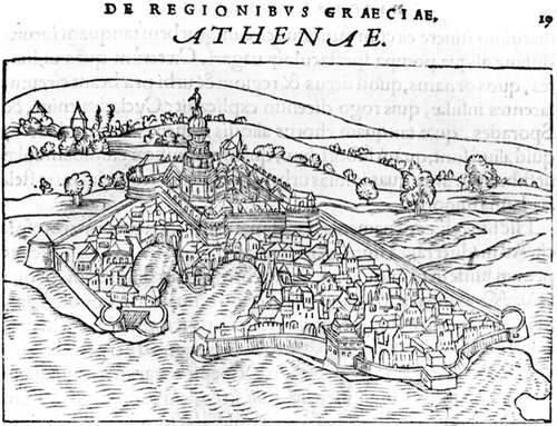
Figure 9 The woodcut view of Thessaloniki from Nicolaus Gerbel,In descriptionem Graeciae Sophiani, praefatio (Basel, Johannes Oporin, 1545, p. 40), is a reproduction of a view of Basel by Konrad Morands reversed left to right. 8×12.5 cm. (Reproduced with permission from the Gennadius Library, The American School for Classical Studies, Athens, GT 11, p. 40.)
The Praefatio concludes with twelve unnumbered pages that contain a long alphabetical list of the approximately two thousand place‐names given on the map, together with their geographical co‐ordinates. At the very end of the volume come the same four laudatory epigrams that are on one of the oblong concordance tables. Although Gerbel acknowledged Sophianos's advisory role in the overall venture, it is not clear whether Sophianos had a hand in the writing of any such introduction to his map and, if so, to what extent he was involved.Footnote57
The map seems to have been in great demand, and Oporin commissioned Master Christoph to cut a new set of views.Footnote58 Then in 1550 Oporin reissued the Praefatio in an expanded edition, now amounting to three hundred pages, with—possibly—another reprint of the map.Footnote59 Oporin's 1550 edition of Gerbel's introduction starts with an elegy composed by Abraham Loescherius, who was also responsible for the translation of Pausanias into Latin (Basel, Oporin, 1550). The rest of the text was a more analytical historical geography of Greece; the content of the 1545 edition was now supplemented with thematic chapters describing the physical geography of Greece (seas, gulfs, mountains and rivers), and the tribes, languages, traditions and customs of ancient Greece.
An interesting addition is Gerbel's detailed instructions on how to colour the map.Footnote60 He directed that the boundaries of provinces and districts should be red or purple (subrobro, violaceo) according to their precedence in the administrative structure. The sea was to be in sky blue (caeruleo). The mountains should be left white, while the rivers were to be made blue (veneto). The forests were to be shown ‘as may be agreed’; the signs for towns and villages were to be coloured violet (ferrugineus color).
The expanded Praefatio, however, is unillustrated except for two mnemonic cartographic schemata, related to the shape of central Greece and Macedonia, on pages 25 and 38 respectively. We may infer, then, that Master Christoph's new views were printed to form a border that was to be issued with yet another reprint of the map (that would, accordingly, be dated 1550) or that was to be added to any remaining copies of the 1545 edition.Footnote61
Venice 1545 and Rome 1552 Editions
In the same year (1545) that Oporin was reprinting his edition of Sophianos's map, a new version was being published in Venice by Giovanni Andrea Vavassore.Footnote62 This much smaller two‐sheet map, which measures no more than 41.5×62 centimetres overall, was engraved on copper. Its bilingual title, Totius Graeciae Descriptio / Απάσης Ελλάδος Π∊ριγραφή, is placed at the bottom of the right‐hand sheet.Footnote63 Prominent in the lower part of the left‐hand sheet, is a large rectangular cartouche in the form of a scroll. This contains Vavassore's note to the reader (‘Ioannes Andreas Vavassorius Vadagninus Lectori S.’), in which he acknowledges that the edition is essentially based on Sophianos's map. Next to the cartouche and near the margin of the map is a divider and a double scale bar in Greek stadia and Italian miles (140 Italian miles or 1,000 stadia = 6 cm.). To the right of the divider is an unidentified coat of arms. The geographical features of this edition are similar to Oporin's 1545 edition. Vavassore has maintained the bilingual (Greek and Latin) labelling of regions and seas, but, because this is a much smaller version than the original he was copying from, he had to omit the vignettes of Athens and Constantinople, as well as the smaller ones of ancient monuments.
It may be suggested that Sophianos himself initiated Vavassore's edition in 1545 or, at the very least, that he was engaged in one way or another in this undertaking, since we know he was in Venice in that year managing his Greek publishing business. If Sophianos were to have been involved, Vavassore's edition could have been based directly on an exemplar of the original Rome edition (1540). Two facts reinforce such a hypothesis. The more important is that his edition is the only known version of Sophianos's map to have a bilingual (Greek and Latin) title. Secondly, Vavassore's version does not incorporate Oporin's cartographic improvements, especially the complex scale bar, although it does have a simple one, identical, it should be noted, to that on the copperplate edition of the map that was published seven years later (1552).
The 1552 edition is large—about 74×111 centimetres—and elegantly engraved. It is printed from four copper plates (Fig. ). The large rectangular cartouche in the bottom left corner of the map is divided into two panels of text. It contains Sophianos's original address to the reader, dated ‘Romae, in templo Boni Eventus, M.D.LII’ (in the left‐hand panel), and the four laudatory epigrams (in the right‐hand panel). A number of differences between Oporin's 1545 woodcut and this new copperplate stand out. The title of the map, Totius Graeciae Descriptio, is at the bottom of the map, in the centre of the frame, and not at the top of the map, and the date is now styled in Roman numerals.Footnote64 The scale bar that Oporin added to the map is lacking, but a double scale bar is found in the border (bottom left). Although no indication is given of which units of measurement were used, we may presume that these are similar to those used by Vavassore, that is, Greek stadia for the left part of the scale bar and Italian miles for the right. The cartouche is no longer ornately decorated.
Figure 10 Nikolaos Sophianos,Totius Graeciae Descriptio (Rome, Antonio Blado, 1552). Copperplate. 4 sheets. 74×110 cm. The motto ‘Bonus Eventus’, here at the bottom of the left panel in the cartouche, was used by Antonio Blado (see Fig. ), the Vatican's official printer who had invited Sophianos to Rome. The plates used for this edition may have been engraved long before, possibly as early as 1540, which would mean this edition reproduces the lost first Rome edition. (Reproduced with permission from the British Library, Maps M.T. 6.g.2.(4).)
It is not too far‐fetched to suggest that this Rome edition not only most faithfully reproduced Sophianos's original draft (apart from the date), but also that it was actually printed from the original copper plates, those used for the now‐lost first Rome edition of 1540, as was suggested by CitationHieronymus in 1984.Footnote65 Indeed, it would be tempting to suggest that the copper plates of the original edition had remained at Rome in the hands of Antonio Blado, together with the Greek typeface that Sophianos had designed for the Vatican's Greek press. Nevertheless, the plates were apparently not part of the printing equipment returned to Sophianos in 1551 when his dispute with Antonio Blado was settled, and no mention is made of them in any related document. The more likely scenario is that the end of the case allowed Blado to reissue the map from the old plates that were still in his possession, a hypothesis supported by the fact that in the 1552 issue his printer's motto (‘in templo Boni eventus’) remains.
Another feature of the 1552 issue that appears to corroborate the suggestion that the plates used for this printing were indeed the old ones from 1540 are the obvious corrections that were made at some stage to the original engraving on the plate. The corrections concern the island of Zante (Zacinthus), to the west of the Peloponnese (Fig. ). A new, correctly delineated, coastline has been placed farther out in the sea, enlarging the island, and new hill signs have been added, but neither the old coastline nor the stippling of the former area of sea has been erased. The two versions of the island are found only on the 1552 edition, which raises the question when the corrections were made. On both Oporin's woodcut edition and Vavassore's engraved copperplate edition (1545), the island is correctly shown. The failure to erase the old coastline and the sea stippling could be accounted for by the inexperience of whoever made the correction, but whether the correction was made in 1552 or had already been done in 1540 (which would explain why all subsequent editions show the island correctly), it is impossible to state. In either case, the person responsible could have been Blado.
Figure 11 Detail from Nikolaos Sophianos,Totius Graeciae Descriptio (Rome, Antonio Blado, 1552). Bottom left is the island of Zante (Zacinthus) with the corrected western coastline; note how the stippling of the sea still appears within the outline of the island. Top left, at Actium, is the temple of the Actian Apollo and the burning altar commemorating Octavian's victory over Marc Anthony's and Cleopatra's armies, in 31 BC, that led to the end of ancient Greek political history. Centre right is the temple to Neptune at Rhion. (Reproduced with permission from the British Library, Maps M.T. 6.g.2.(4).)
Later Copies of Sophianos's Map
Exactly when the Rome publisher Francesco Salamanca produced his own reduced edition of Sophianos's map on two sheets (about 41×62 cm) is unclear, but it appears to have been before 1558.Footnote66 Most probably this edition was not based on Vavassore's 1545 Venetian version on two sheets, but on the 1552 Rome reissue of the map by Antonio Blado, since it includes the vignettes of Athens and Constantinople, and the illustrations of the ancient monuments. Salamanca's edition was copied in Rome by Vincenzo Luchini, in 1558.Footnote67 Subsequently it was reproduced in Venice by Paolo Forlani (1562), Ferrando Bertelli (1564, engraved on copper by Domenico Zenoi [Zenoni]), Giovanni Francesco Camocio (1566, engraved on copper by Paolo Forlani), and Donato Bertelli (1569).Footnote68 Francesco Salamanca's edition was also reproduced in Rome by Antonio Lafreri (1570) and Claudio Duchetti (after 1570). Footnote69
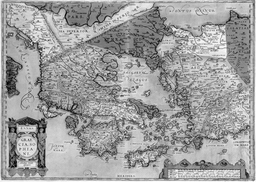
Finally, in 1579 a new version of the map appeared, on one sheet (about 35×50 cm), as part of Abraham Ortelius's Parergon, under the title Ελλάς. Graecia Sophiani (Fig. ).Footnote70 Ortelius's edition was evidently not based on the Italian two‐sheet reduced editions of the map, but directly on the 1545 Basel Oporin edition, since it contains the scale bar in four different units (stadia and German, Gallic and Italian miles) worked out by Christman Herlin.
Figure 12 Abraham Ortelius,Ελλάς, Graecia, Sophiani (Parergon, Antwerp, 1579). Copperplate, 35×50 cm. Ortelius paid Sophianos the unique compliment of including his name as the originator of the map in the title. (Reproduced with permission from the Margarita Samourka Collection, Athens.)
Much later, in 1601 in Basel, Johannes Schroeterus printed the last woodcut edition of Sophianos's map of Greece from Oporin's blocks. For this edition Oporin's dedication to Cosimo de' Medici was changed to Andreas Ryff (1550–1603), the influential Basel merchant, politician and historian, and Sophianos's address to the reader was replaced by a new text composed by the antiquarian scholar, Iacobus Grasserus.Footnote71
The year 1699 saw a final flurry of activity: Gerbel's 1545 Praefatio was reissued by Jacobus Gronovius in the fourth volume of his magisterial, thirteen‐volume Thesaurus graecarum antiquitatum.Footnote72 Gronovius's edition included Ortelius's version of Sophianos's map, Graecia, Sophiani, and twenty‐one views by the Flemish artist Jan Goeree, also engraved, were printed three to a page. The views are rather loosely based elaborations of those in Gerbel's original (1545) edition of the book. With Gronovius's publication, the printing history of Sophianos's great cartographical work, the mapping of Greece, came to a close.
The Content of Sophianos's Map
Ptolemy's Geography provided the basis for Sophianos's map. The outlines, the representation of the relief, the network of rivers, and the internal division of Greece into countries or tribes, whose boundaries and names he marked on his map, are all visibly Ptolemaic. Nevertheless, Sophianos revised many of the details, such as the outlines of Corfu, Cephalonia and Zante in the Ionian Sea, the southern coastline of the Peloponnese, and the size and the arrangement of the Cyclades in the Aegean Sea.
He also departed from the traditional model of Greece that Ptolemy, following the ancient Greek geographers, had used and proposed instead a new regional definition of Greece. Whereas Ptolemy's Greece extended northwards as far as Epirus and Macedonia, on Sophianos's map Greece embraced all of the Balkans south of the Danube as well as western Asia Minor. Thus, in seeking a base for his own map, Sophianos had first to join together two of Ptolemy's maps of Europe, Tabulae Europae IX and X, which show the Balkans south of the Danube, and then to add the western part of Tabula Asiae I, which shows Asia Minor. To this he appended a small part of southern Italy from Tabula Europae VI. He retained the Ptolemaic graticule of latitude and longitude as well as the division of the latitudes into climates.
Although exceptional, Sophianos's broad territorial definition of Greece was not unique. There were antecedents for his perception of a greater Greece. The tenth map of Europe in the first edition of Ptolemy's Geography with maps (Bologna, D. de Lapis, 1477), one of the additional ‘modern’ maps in Martin Waldseemüller's edition of Ptolemy (Strasbourg, Schott, 1513)—the ‘Tabula moderna Bossine, Servie, Greciae et Sclavonie’—and the map of Greece in the second edition of Solinus's Polyhistor (Basel, M. Isengrin and H. Petri, 1538), all show Greece extending into the Balkans, Asia Minor and southern Italy (Magna Graecia) as on Sophianos's map.Footnote73 In contrast, Gerbel's definition of Greece, as described in his Praefatio, covered only those regions included in Strabo's and Ptolemy's Greece, with the addition of Magna Grecia.
Another innovative feature of Sophianos's map in comparison with his Ptolemaic model is the chronological range and wealth of the place‐names. Ptolemy had only depicted the geographical realities of the second century ad, but Sophianos aimed to embrace the entire span of ancient Greek history. Where Ptolemy listed approximately a thousand places for the areas covered by the maps corresponding to Sophianos's Greece, Sophianos, according to Gerbel's list, had two thousand places, which he had drawn from a variety of sources, as acknowledged in his address to the reader. First, Sophianos had used the Greek historians and geographers—Herodotus, Thucydides, Strabo and Pausanias—then recent maps and charts, and finally Ptolemy's Geography.Footnote74 For Ptolemy, Sophianos claimed to have consulted a large number of the early manuscripts.
It is interesting to find Pausanias's antiquarian description, a source unexploited by earlier scholars, cited among Sophianos's main references.Footnote75 Sophianos acknowledged his debt to Pausanias directly through his formal acknowledgement and indirectly through his adaptation of Pausanias's title (Graeciae Descriptio) as the title of his map (Totius Graeciae Descriptio). His debt to Pausonias is also evident in the distribution of the place‐names on the map, which is much denser in the regions covered by the Description of Greece, such as Fokis, Attica and the Peloponnesus.
All the geographical material recorded on Sophianos's map refers to antiquity. The place‐names are those relevant for the period from the Argonauts and the Trojan War (supposedly twelfth century bc) to the late Roman period (fourth century ad). With the exception of ‘Byzantion‐Constantinopolis’, no Byzantine, Frankish or Ottoman names appear. Such Byzantine fortified cities as Didymoteikhon and Mistra in Greece are absent, as are Bodonitza (Mendenitsa in Lokris) and Vostitza (Aigion in northern Peloponnesus), Slavic settlements dating from the sixth and ninth centuries respectively, and built on ancient sites that became seats of important Frankish baronies. Scutari (Üsküdar), the Ottoman's Asiatic harbour for Constantinople, and Tripolitza (Tripolis), the Ottoman capital of Morea, are ignored. The names of mountains, rivers, lakes and seas are likewise those of ancient times.
The sixteenth‐century reader of Sophianos's map was expected to locate medieval and modern places by using the separately provided concordance of 276 names and to match the numbers by the places on that list with those on the map. On the map, place‐names are in their Hellenized Latin form, with Roman letters spelling the Greek names. An interesting feature is the parallel use of both Greek and Latin letters and names for some countries, regions, tribes and seas (Fig. ). In 1545 Vavassore followed this practice for the title of his map.
Figure 13 Detail from Nikolaos Sophianos,Totius Graeciae Descriptio (Rome, Antonio Blado, 1552), showing the city of Byzantion‐Constantinopolis, the temple of Diana, and the ruins of Troy (Ilium, bottom left). Note the parallel use of Greek and Latin for the names of the seas: Propontis (Sea of Marmara) and Euxine (Black Sea). (Reproduced with permission from the British Library, Maps M.T. 6.g.2.(4)).
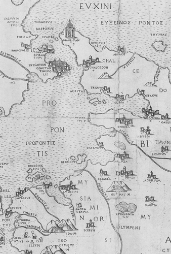
It is appropriate that Troy (called Ilium on the map) is the sole settlement to be depicted as a ruin, since the site of the ancient city marks the oldest level of Greek history represented on the map. For Herodotus, as for all the Greek historians, the Trojan War marked the starting point of history. An alternative explanation for the depiction of Troy as a ruin could be that it is an allusion to the mythical origins of Rome, celebrated by the Roman poet Virgil in The Aeneid, which was believed to have been founded by Aeneas after his flight from Troy. The other end of the timescale represented on the map would seem to be marked by ‘Byzantion‐Constantinopolis’—the only city to be given both its ancient and its modern name—to which the capital of the Roman Empire was moved at the beginning of the fourth century ad.
The woodcut and the copperplate versions of Sophianos's map present very different images. The woodcut 1545 Basel edition is strongly pictorial. The rich and varied iconography used for physical features such as relief and vegetation, and for human features such as cities, fortresses and the smaller settlements, adds a degree of realism to the representation. The shading suggests the third dimension. The seas are embellished with ships, sea monsters and mythological scenes that add to the theatricality of the enterprise.
In contrast, the engraved lines of the 1552 Rome copperplate version create a more delicate image, further lightened by less elaborate ornamentation. The map signs tend to be smaller and more homogeneous. There is less variation in the size and shape of hill and tree signs. Instead of the apparently random differences in the styling and sizes of the settlement signs on Oporin's woodcut, on the copperplate we can easily discern distinct categories of settlement, each represented by a sign of different style and size to denote villages, fortresses, smaller towns and larger towns. There is no absolute consistency, however; whereas the smaller towns are indicated by a single tower, the sign for the larger towns may include two, three or four towers, with walls added for the largest towns of all.
Two cities alone have been singled out for special representation on both versions. Large pictorial vignettes stand for the two major cultural and political centres of classical and late antiquity, Byzantium and Athens. These schematic vignettes nonetheless portray something of the ancient aspect of the towns. Byzantium is represented as a walled town with the cathedral of Saint Sophia in the centre (see Fig. ). Athens, the principal city on the map, is depicted with the Acropolis in the centre, its harbour at Piraeus and the long walls enclosing both city and harbour (Fig. ). This impressive vignette covers a large part of Attica.Footnote76
Figure 14 Detail from Nikolaos Sophianos,Totius Graeciae Descriptio (Rome, Antonio Blado, 1552), showing the disproportionately large map sign for Athens. The vignette is similar to the woodcut view of Athens published in Nicolaus Gerbel's In descriptionem Graeciae Sophiani praefatio (Basel, Johannes Oporin, 1545), p. 19 (see Fig. ). Note also the five temples (Delos, Delphi, Pythia, and two sanctuaries dedicated to Diana). (Reproduced with permission from the British Library, Maps M.T. 6.g.2.(4).)
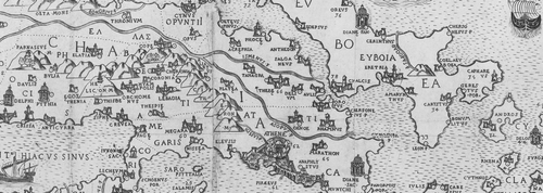
Ancient Greek and Roman monuments, taken from Strabo, Pliny and, above all, Pausanias are also discernible. The signs used for these buildings reflect Roman rather than Greek architecture. As might be expected, the sacred centres of the Greek world, Delos and Delphi, are marked, the latter with two temples, one labelled ‘Delphi’ and the other ‘Pythia’ (see Fig. ). So are, more surprisingly, the three sanctuaries dedicated to Diana: one just north of Byzantium at the Asiatic end of the Bosporus, another on the island of Euboea and the third east of Athens at Vravron in Attica. Four other sanctuaries are marked by smaller signs: the temple of Juno Acraea–Limenia near Corinth; Neptune's at Rhion; Apollo's Nymphaeum near Apollonia in Illyria; and Apollo's temple in Actium, Epirus, western Greece. The sanctuary of the Actian Apollo is shown together with the hill and the woods referred to by StraboFootnote77 (see Fig. ). Not far from this sanctuary is the burning altar that celebrated the Roman emperor Octavian's victory over the combined forces of Anthony, Cleopatra and the Greeks in 31 bc and symbolized the final unification of the Greek East under Roman rule.
Using Sophianos's Map
Although no documentary evidence has yet come to light to explain what inspired Sophianos to make his map, the political factor can almost certainly be excluded. By the time the map was printed in 1540, the war of 1538–1540 between the Holy League and the Sultan had already reached its inglorious close, and the map would have served no military function.Footnote78 Rather, we should seek Sophianos's motives in the intellectual priorities of the humanistic and antiquarian environment within which his career had evolved, and where his map and its reader aids were received with enthusiasm by his contemporaries.
As already noted, the woodcut version of the map was republished at least twice in the decade following the original Rome edition of 1540, once by the humanist publisher Johannes Oporin and once, as a copy on copper, by Vavassore. It was praised by the scholar Konrad CitationGesner and appreciated by antiquarians and geographers such as Antonio Augustin, Johannes Metellus and Joachim Vadianus, and Hellenist humanists such as Arlenius Peraxylus and Philaenus Lunardus. Nicolaus Gerbel, author of the commentary that accompanied Oporin's woodcut edition, compared the map's creator to the great Byzantine philosopher and humanist George Gemistos Plethon (c.1355–c.1450).
The enthusiastic interest of the humanists in Sophianos's map led to its widespread diffusion. From 1545 onwards, the map was copied and reproduced by some of the major map publishers of the time—Giovanni Andrea Vavassore, Francesco Salamanca, Paolo Forlani, Giovanni Francesco Camocio, Donato Bertelli, Abraham Ortelius—and became a cartographical bestseller for the remainder of the century. In one version or another, indeed, Sophianos's map was commonly found in sixteenth‐century map collections, in public and private libraries, in composite atlases, even redrawn by hand for a manuscript atlas; it was listed in Frankfort book fair catalogues.Footnote79
The acclaim given to the work by contemporary scholars has to be explained by the fact that the map and its accessories supplied answers to a number of basic and long‐standing problems relating to the geography of ancient Greece. In the eyes of his contemporaries, Sophianos's map was superior to the Ptolemaic tabulae of Greece—both ‘ancient’ and ‘modern’—by virtue of its larger size, the more‐detailed representation of physical features and the wealth of information portrayed. The last reflects the variety of Sophianos's sources, the wide timespan covered (which permitted the recording of data already out of date by Ptolemy's time) and, finally, the map's accompanying list of ancient and modern place‐names.
For any sixteenth‐century scholar, a project involving analysis of the physical and human landscape over a thousand years of ancient Greek history was a challenging endeavour. All sorts of sources had to be searched for the relevant information, contradictions had to be resolved, and the selected data had to be correctly positioned on the map. The map Sophianos produced was a valuable antiquarian tool. It allowed him to display his own classical learning, which he was able to improve on as he checked what were considered to be the most reliable geographical records of his day—Ptolemy's Geography and portolan charts. It also allowed him to go further than his sources to produce a supplementary concordance of the ancient and modern place‐names of Greece.
A major problem for anyone wanting to know the location and present‐day name of a place mentioned in an ancient text was that of subsequent changes in toponymy. Byzantine scholars, who were well aware that place‐names were liable to change over time and that many ancient settlements were remembered only by their names, were the first to compile lists of former and current names.Footnote80 In the Latin West, however, scholars paid attention to the question only from the fourteenth century onwards. As Petrarch made clear in his comments on Virgil, the need was to discover the correct position and spelling of ancient localities that had disappeared or whose names had become corrupted or been replaced over the centuries.
Lists of ancient and modern place‐names were added to maps early in the Renaissance. Some of the fifteenth‐century manuscript copies and printed editions of Ptolemy's Geography contain lists of modern equivalents for use with the maps.Footnote81 Later on, towards the end of the sixteenth century, it became a relatively common practice to provide such lists to accompany separately printed maps or to be included in atlases as well as in antiquarian geographical description.Footnote82
For Renaissance humanists in western Europe, the problem of identifying ancient Greek locations was complicated. Greece was far away, and the recent Ottoman invasion of eastern Europe had brought about abrupt changes in the country, adding to the slow corrosion of toponyms over time.Footnote83 Sophianos's alphabetical concordance table of ancient and modern place‐names was the first such aid for Greece. Despite Sophianos's clear intention, his list was in fact of little real help when it comes to finding a modern place on the map, since the numbers follow no coherent pattern. The problem was corrected only much later, in Lafreri's reissue of Sophianos's concordance in 1570, in which geographical co‐ordinates replaced the arbitrarily numbered names of the original.Footnote84
The list of place‐names compiled by Gerbel and published as an Appendix to his Praefatio was also intended as an aid to the reader of works about ancient Greece and to facilitate finding a place mentioned therein.Footnote85 Like Sophianos, Gerbel listed the names in alphabetical order, but unlike the mapmaker, he keyed them to the map by means of geographical co‐ordinates. Gerbel evidently did not anticipate a high level of map literacy among his readers, for he took the trouble to explain the system of parallels and meridians and the way they were to be used to define a place's geographical position, thus ensuring the successful use of the gazetteer.Footnote86
Interest in different ways of visualizing and tabulating knowledge was characteristic of sixteenth‐century humanism, as was the humanists' preoccupation with history and its pedagogical applications.Footnote87 Sophianos's map offered scholars and students a composite visual medium, a sort of antiquarian geographical compendium that summarized the totality of ancient geographical knowledge as it related to Greece. As Oporin, addressing Cosimo de' Medici, noted in his dedication of the 1545 edition of Sophianos's map, it was useful and necessary for understanding Greek historians and poets.Footnote88
Gerbel's Praefatio is even more fulsome in its praise of the usefulness of Sophianos's map: the map clarifies the narratives of the Iliad, the Odyssey, the account of the Argonauts' expedition and Virgil's poems, and it serves as a guide to the histories of Thucydides, Xenophon and Livy. More than that, Gerbel pointed out, the map ‘enlightens the reader and makes his reading more enjoyable’; with the help of the map, the reader can see at a glance how, for example, the Greeks sailed from Aulis and how they reached Troy, how Helle was drowned in the Hellespont, why Virgil described Aeneas's voyage as a periplus, and why Xerxes had to cut a canal across the Athos peninsula.Footnote89 Finally, Gerbel concluded, ‘With the picture of the whole of Greece before your eyes, history and literature are no longer unintelligible, no longer shrouded in Cimmerian darkness’.Footnote90
The enthusiasm that greeted Sophianos's map testifies to the character of sixteenth‐century antiquarian interests and the growing trend of giving the past a visual dimension.Footnote91 Abraham Ortelius expressed the common belief in the instrumental character of maps when he observed in the preface to his Theatrum Orbis Terrarum, quoted here from the 1607 English edition, ‘The reading of histories doeth both seeme to be much more pleasant, and indeed so it is, when the Mappe being layed before our eyes, we may behold things done, or places where they were done, as if they were at this time present and in doing’.Footnote92
Functions of Sophianos's Map
Sophianos's map should be seen in the context of the new textualism of Renaissance humanism and in the light of the humanists' emphasis on a critical approach to ancient texts.Footnote93 Although the map was promoted—and eventually employed—as an aid in the elucidation of ancient historical and literary works, it cannot be defined as a historical map in the current sense of the term, nor was it understood as such by its users.Footnote94 In no contemporary source is it defined as a map of ancient Greece; CitationGesner for example, described it as a work with both ancient and modern place‐names.Footnote95
According to the early sixteenth‐century humanist's sense of antiquity, time was a cyclical and repetitive process, and history, following Cicero's definition, was conceived as the tutor of life (Historia magistra vitae).Footnote96 Since both classical and Christian antiquity provided the paradigm for modern society, Renaissance humanists wavered between a past that was at one and the same time already accomplished and yet was expected to be reborn.Footnote97 Humanists were aware of the differences between the present and the past, however, and early sixteenth century antiquarian cartographers offered a variety of solutions to the problem of depicting past and present on maps, such as presenting ancient and modern maps of the same area side by side (as in editions of Ptolemy's Geography from 1513—Schott's Strasbourg edition—onwards), as in the use of different types of font on the same map,Footnote98 or, as in Sophianos's case, cross‐referencing between the map and a separate concordance table of ancient and modern place‐names.
Sophianos's map has to be defined as an antiquarian map. In it, Greek antiquity is displayed as a palimpsest on which is registered, without distinction, historical and mythological elements drawn from the whole sequence of the ancient Greek legacy. Totius Graeciae Descriptio, in short, displays the successive periods of Greece's history and mythology as a static unit. The map covers a huge span of time. It ranges from mythical and Homeric times (represented by places such as Iolkos, the Argonauts harbour, Nestor's Pylus, and Homeric Assine or Mycene), to those of the late Roman and early Byzantine empires (represented by places such as Nicopolis that recall valiant Roman deeds or, as in the cases of Traianopolis, Adrianopolis and Constantinopolis, the emperors who founded them). It does, however, set out a clear demarcation between the ‘modern’ and the ‘antique’. Indeed, we may deduce that the differentiation between ‘past’ and ‘present’ was clear to Sophianos from the fact that he included places that were still known by their ancient names, such as Argos, Cassandria and Megara in his concordance table of ancient and modern place‐names.
Sophianos's map can also be seen as conveying symbolical values that reflected the cultural and political preoccupations of the time. In the context of the 1540s, the map could have served to promote Greek patriotism by celebrating a cultural (historical and religious) definition of Greece through the portrayal of the allegedly devastated Christian territories of the former Byzantine Empire as richly endowed by their Greek and Roman ancestry.Footnote99 Nevertheless, the map was mainly addressed to Western readers. The intention was to restore the cartographical image of ancient Greece and thus to stipulate that Greece was a historical, geographical and, thanks to the names of regions and seas lettered in Greek, linguistic reality, not just a scholarly and artistic idea regained through Latin reminiscences. It is precisely the restoration of Greece that was being celebrated by Gerbel and Oporin, and by the laudatory epigrams, especially that composed by Faustinus Buturinus Veronensis:
As everything changes, so did Greece the ingenious
Whose aspect, Sophianos, you have restored.
Now its true figure, neither Jupiter's fury nor any calamity
Could ever again abolish.Footnote100
It is worth questioning what exactly this Greece that the map had restored and regained was. In fact, Sophianos's broad regional definition of Greece does not correspond to any territory described by the ancient historians and geographers. Although nothing on the map makes explicit to which layer or layers of Greek history the definition applies, Sophianos's main sources (Strabo, Pausanias and Ptolemy) were all concerned with the realities of the imperial period. Consequently, the emphasis in the map is on the Roman era, from the subjugation of the Greek territories by the Roman Empire (which were thus unified for the first time in their history) to the transfer of the empire's capital from Rome to Constantinople, the map's final temporal boundary. The same period was also that of the spread—through Saint Paul's peregrinations and the founding of the earliest Christian communities—and consolidation of the Christian faith through the activities of the Church Fathers and the first Ecumenical Councils, such as those of Nicaea, Constantinople, Ephesus and Chalcedon.
Sophianos's definition of, and perspective on, Greek antiquity were linked to a specific perception of Greece as part of the unified and Christianized Roman world and, to some extent, to the survival of this world as the Eastern Roman Empire. Sophianos's map has to be understood as an expression of the spirit of universal Christian humanism that prevailed in Rome under the humanist popes before the Council of Trent (1545–1564). This spirit of the universality of Christianity produced the Quirinal College, the Vatican's Greek press, the Alcala polyglot edition of the Bible and the magnificent illustrations in the cycle of frescoes painted by Raphael for the Vatican's Stanza della Signatura (particularly the legendary ‘School of Athens’ fresco, an allegory of the fusion of ancient philosophy and Christian theology).
Sophianos's map can be seen as an outcome of the Vatican's spirit of universality and the expansionist implications of that spirit. Its success, however, lay in its association with the intellectual climate of the Reformation, which turned towards Greek as the language of the early Church and, more incidentally, to the use of maps in explanation and support of the sacred texts.Footnote101 It is thus no coincidence that Joachim Vadianus was one of the first humanists to be interested in Sophianos's map, that Nicolaus Gerbel, the Hellenist who undertook to ‘explain’ and promote the map to the public, was a militant Protestant, the editor of a new edition of the Bible in Greek and an intimate of Philip Melanchthon and Martin Luther, and that the map had a definite impact on Sebastian Münster's cartography of Greece.Footnote102
There are indeed quite a few parallels and even connections between the map's publishing history and the context of the ‘Battle of Greek’ in the first half of the sixteenth century.Footnote103 Although the map was not connected to the doctrinal quarrels related to the status of Greek as a literary, sacred and living tongue, its diffusion was inevitably affected by the issue. The first edition of the map, that from the Vatican Greek press, dropped out of sight during the period when the Catholic Church looked upon the Greek language as a dangerous tool in the hands of the Reformation, and Hellenists and their publishers risked being placed on the Index librorum Prohibitorum.
In contrast, the map was widely disseminated in Switzerland, where the Reformation was flourishing. Later on, through its inclusion in Ortelius's Parergon (1579), it was distributed throughout the Low Countries, another Reformation stronghold, especially among adherents of the Family of Love, whose universalistic mysticism was evolving on the fringe of the Counter‐Reformation.Footnote104 In the final analysis, it has to be said, the survival and success of Sophianos's map over the following two centuries owed much to Oporin and, then, to Ortelius. The very title he gave to his version of the map—Eλλάς. Graecia, Sophiani (Eλλάς. Sophianos's Greece)—endowed it with an archetypal lustre: this was a distinction he conferred upon no other cartographer represented in his atlases.
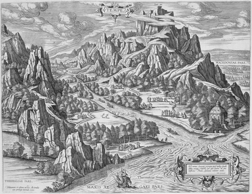
Sophianos's map of Greece lay at the heart of the Parergon. For Ortelius the map represented a decisive step in his exposition of the providential design of the world, which he went on to develop further in successive editions of the Parergon. The exposition started with the ancient peregrinations, from Abraham and the Argonauts to Ulysses and Aeneas, and was followed first by the establishment of the Greek states and the political unification of the ancient world under the Roman Empire and then by the spread of the Christian faith. After this were presented the actual instruments of Providence: the Lords of the Holy Roman Empire and the Escorial—the emperor's residence with its vast library, said to contain the entire memory of the world.Footnote105 In addition, the Parergon contains two pictures of mythical paradises, places of poetic reflection: one is of Apollo's temple in Daphne and the other—inspired by Master Christoph's woodcut in Gerbel's Praefatio (1545)—of the valley of Tempe in Thessaly (Figs. and ).Footnote106
Figure 15 Woodcut view of Tempe from Nicolaus Gerbel,In descriptionem Graeciae Sophiani praefatio (Basel, Johannes Oporin, 1545), p. 48. Gerbel's description and Christoph Schweicker's illustration are based on Aelian's description of the valley as a locus amoenus, a place of pleasure and poetical reflection. 8×12.5 cm. (Reproduced with permission from the Gennadius Library, The American School for Classical Studies, Athens, GT 11, p. 48.)
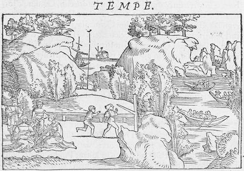
Figure 16 Abraham Ortelius's copperplate version— delineatum et editum auctore Ab. Ortelio, 1590—of the view of Tempe in Nicolaus Gerbel's In descriptionem Graeciae Sophiani praefatio (Basel, Johannes Oporin, 1545), p. 48 (see Fig. ). From the Parergon (Antwerp, C. Plantin, 1595). (Reproduced with permission from the Gennadius Library, The American School for Classical Studies, Athens, Φ50, p. 68.)
By including Sophianos's Greece in the Parergon, Ortelius ensured its longevity. Its endurance came with a price, however, for although the map continued to be regarded as authoritative, its original function was lost. From being a useful tool in antiquarian research, it gradually became an antiquarian object itself. Christos CitationZacharakis records the publication of dozens of versions of Ortelius's Ελλάς. Graecia, Sophiani in the seventeenth and eighteenth centuries in atlases, treatises on ancient geography and books on Greek history.Footnote107
There is little point in questioning whether Nikolaos Sophianos was Orthodox or Catholic. He had been brought up in the spirit of Christian universalism that prevailed in Rome at the time. Similarly, it is pointless to wonder whether he was attracted by the Reformation or influenced by Christian neo‐Stoic ideas, or whether he tended instead towards empirical scepticism, as could be presumed from his early interest in Pyrrhonism.Footnote108 Sophianos was not a theorist. On the contrary, as CitationLegrand points out, he had an ‘eminently practical mind’.Footnote109 As a mapmaker he was called upon to find empirical solutions to abstract and fluid issues relating to the character of Greek antiquity, its relation to the present and its bearing on the thinking of the Renaissance intelligentsia.
Sophianos's project of publishing a comprehensive map, large enough to be displayed on the wall and to show the Greek territories from mythical times to the founding of the Eastern Roman Empire and the establishment of Christianity, had been aimed at promoting the idea that Greece was an active and still present component of the Christian and humanist legacy. Furthermore, the project was in line with antiquarian commitment to the artefactual, geographical and topographical evidence of the past. For the scholarly elites of western Europe in the early sixteenth century, Totius Graeciae Descriptio functioned as a visual digest of Greece. It demonstrated and tabulated the geographical setting of the Greek and Latin classics, both literary and historical. Thanks to Sophianos's concordance and Gerbel's commentary with its gazetteer, ancient place‐names could be verified and changes in their names over time traced. At the same time, the vibrant iconography of the map signs, together with Master Christoph's book illustrations, provided the map user with a rich, albeit imaginary, topographical and architectural testimony to the landscape of ancient Greece.
The welcome accorded to the map and its wide dissemination ensured that the emphasis on ancient as well as modern Greece became an integral element in sixteenth‐century humanism. Nikolaos Sophianos's remarkable work rapidly acquired authority and was soon established as the standard reference work that deepened the objectives of comparative geography. The antiquarian discipline of studying the ancient and modern in parallel as promoted by Sophianus was destined to have a conspicuous career throughout the seventeenth and eighteenth centuries.Footnote110
Acknowledgements
Thanks are due to CitationChristos Zacharakis and Constantine Staikos for their aid in locating Sophianos's maps, to Catherine Delano Smith for her constant advice, and to the anonymous Imago Mundi referee for helping me to avoid mistakes and misjudgements.
Notes
Dr George Tolias is Research Director, Institute for Neohellenic Research, The National Hellenic Research Foundation.
1. On the relations between history and cartography in the 14th century, see Patrick Gautier Dalché, ‘L'espace de l'histoire: le rôle de la géographie dans les chroniques universelles’, in L'Historiographie médiévale en Europe, Actes du colloque organisé par la Fondation Européenne de la Science au Centre de Recherches Historiques et Juridiques de l'Université de Paris I du 29 mars au 1er avril 1989, ed. J.‐P. Genêt (Paris, Presses du CNRS, 1991), 287–300; Nathalie Bouloux, Culture et savoirs géographiques en Italie au XIVe siècle (Turnhout, Brepols, 2002). On 15th‐century antiquarian Florentine cartography, see Sebastiano Gentile, Firenze e la scoperta dell’ America. Umanesimo e geografia nel ’400 fiorentino (Florence, Leo Olski, 1992). On historical atlases, see Jeremy Black, Maps and History: Constructing Images of the Past (New Haven and London, Yale University Press, 1997); Walter A. Goffart, Historical Atlases: The First Three Hundred Years, 1570–1870 (Chicago, University of Chicago Press, 2003).
2. On Greek studies during the Renaissance, see Anthony Grafton and Lisa Jardine, ‘The new subject: developing Greek studies’, in From Humanism to the Humanities: Education and the Liberal Arts in Fifteenth‐ and Sixteenth‐Century Europe (London, Duckworth, 1986); Carlotta A. Dionisiotti and Anthony Grafton, The Uses of Greek and Latin: Historical Essays (London, Warburg Institute, 1988); Jean Michel Saladin, La bataille du Grec à la Renaissance (Paris, Les Belles Lettres, 2000).
3. On the ‘universal spirit’ of the age, see Denis Cosgrove, ‘Globalism and tolerance in early modern geography’, Annals of the Association of American Geographers 93 (2003): 852–70. On the contacts between Catholicism and Orthodoxy, see Deno J. Geanakoplos, Byzantine East and Latin West: Two Worlds of Christendom in Middle Ages and Renaissance: Studies in Ecclesiastical and Cultural History (Hamden, Conn., Archon Books, 1966).
4. His father was Pavlos Sophianos, as is known from a letter written to him by Cardinal Bessarion (F. D. Mavroidi, ‘Ειδήσ∊ις για τα ∊λληνικά τυπογραφ∊ία της Ιταλίας τον 16ο αιώνα’, Δωδώνη 4 (1975): 237 n.2). Pavlos may have been the Sophianos mentioned in the sources as having taught Greek in Rome towards the end of the 15th century (Andreas CitationMoustoxydis, ‘Νικόλαος Σοφιανός’, Ελληνομνήμων 4 (April 1843): 236–56, esp. 236–37, 242, and 5 (May 1843): 257–64). On Nikolaos Sophianos, see also H. Hodius, De Graecis illustribus (London, 1742), 309–11; Émile CitationLegrand, Bibliographie Hellénique ou description raisonnée des ouvrages publiés en Grec par des Grecs au XVe et XVIe siècle (Paris, 1885), 1: clxxxvii–cxciv; Robert W. Karrow, CitationJr., Mapmakers of the Sixteenth Century and Their Maps: Bio‐Bibliographies of the Cartographers of Abraham Ortelius, 1570 (Chicago, Speculum Orbis Press for the Newberry Library, 1993), 495–99 (‘Nicolaos Sophianos, Soffiano, Sophianos’); Evro CitationLayton, The Sixteenth Century Greek Book in Italy: Printers and Publishers for the Greek World (Venice, Library of the Hellenic Institute of Byzantine and Post‐Byzantine Studies, 1994), no. 16, esp. 460–72 (‘Nikolaos Sophianos, fl. 1533–1552’).
5. Sophianos attended the Greek College on the Quirinal Hill (ad Caballinum Montem) in 1515 or 1516. The college had been founded by Pope Leo X in 1513–1514 but soon closed, most probably on the pope's death in 1521. Sophianos's fellow pupils were young Greeks who were in Rome as students, boys of mixed social origins who came from various parts of the Levante Veneto and the Peloponnese. See Vittorio Fanelli, ‘Il ginnasio greco di Leone X a Roma’, Studi romani 9 (1961): 379–93; Saladin, La bataille du Grec à la Renaissance (see note 2), 101–22.
6. The Orthodox authorities in Constantinople did not approve the Council's decisions and anathema was pronounced against the pope. The bibliography on the Council of Ferrara–Florence is extensive. For a succinct overview, see Joseph Gill, Le Concile de Florence (Paris, Desclée de Brouwer, 1964).
7. Deno J. Geanakoplos, Greek Scholars in Venice: Studies in the Dissemination of Greek Learning from Byzantium to Western Europe (Cambridge Mass., Harvard University Press, 1962).
8. See M. Petrocchi, La politica della Santa Sede di fronte all’ invasione ottomana (1444–1718) (Naples, Libreria Scientifica Editrice, 1955); also Kenneth M. Setton, The Papacy and the Levant (1204–1571), esp. vol. 3, The Sixteenth Century to the Reign of Julius III (Philadelphia, The American Philosophical Society, 1984).
9. Mariarosa Cortesi and Enrico Maltese, eds., Dotti bizantini e libri greci nell'Italia del secolo XV. Atti del convegno internazionale (Napoli, M. d'Auria, 1992); Saladin, La bataille du Grec (see note 2). The literature on scholars of the post‐Byzantine diaspora is extensive. A wealth of information about Greek books in 16th‐century Italy is to be found in CitationLayton, The Sixteenth Century Greek Book in Italy (see note 4), with an extensive bibliography.
10. Sophianos catalogued the library of Cardinal Niccolò Ridolfi, the pope's nephew. See R. Ridolfi, ‘La biblioteca del cardinale Niccolò Ridolfi (1501–1550). Nuovo contributo di notizie e di documenti’, La bibliofilia 31 (1929): 173–93.
11. Sophianos appears to have treated the Sceptic philosopher's empirical materialism and subversive aphorisms as relief from his strenuous mental exertions. In his dedicatory verses addressed to Georges de Selve he remarked: ‘Do not look for beautiful writing, O excellent ambassador of the Celts and glory of wise men, my own good and noble benefactor; for this book is full of humorous sallies and was written extempore, at great speed, by a hand tired out by hard labour. Those who tire themselves out by writing ought to be paid’. Quoted in CitationLegrand, Bibliographie Hellénique (see note 4), 1: clxxxix. Sophianos's copy of the Pyrrhonian Sketches is now in the Bibliothèque Nationale de France (MS Parisinus 1963 (anc. Fond grec)). On the impact of Pyrrhonism in Renaissance thought, see Pierre‐François Moreau, ed., Le scepticisme au XVIe et au XVIIe siècle (Paris: A. Michel, 2001). On the other surviving manuscripts copied by Sophianos, see CitationLegrand, Bibliographie Hellénique (note 4), 1: clxxxix–clc. Konrad CitationGesner mentioned others that he saw in Sophianos's library in Venice (CitationKonrad Gesner, Bibliotheca universalis, sive Catalogus omnium scriptorum locupletissimus, in tribus linguis, latina, graeca et hebraica (Zurich, C. Froshauer, 1545), entries on Nicolaus alias Laonicus, Philon, Apollonius Dyscolus, Dionysius Byzantinius, Eustathios).
12. On Sophianos's dictionary of modern Greek, see CitationLegrand, Bibliographie Hellénique (note 4), 1: cxciv. Sophianos also promoted living forms of the Greek language by making a copy of a vernacular literary text, the Chronicle of the Palatine Counts Tocco (G. Schirò, ‘Un apografo della Cronaca dei Tocco prodotto da Nicola Sofianòs’, Revue des Études Sud‐Est Européennes 7 (1969): 209–19). He also collaborated in the writing of the Commedia dei Tre Tiranni by A. Ricchi, created for Luigi Gritti, a prominent politician who was a natural son of the Doge Andrea Gritti and a Greek lady from Constantinople. The play relates the adventures of Byzantine refugees in Italy. Sophianos's contribution consisted of passages of dialogue in Grechesco, a Greco‐Venetian dialect of the late 15th and early 16th centuries which was current in Venice thanks to the mass influx of Greek‐speaking refugees after the fall of Constantinople. See Mario Vitti, Nicola Sofianòs e la commedia dei tre tiranni di A. Ricchi (Napoli, Istituto Universitario Orientale. Seminario di Greco Moderno, 1966).
13. For Antonio Blado, see F. Barberi, ‘Blado, Antonio’, Dizionario Biografico degli Italiani 10 (1968): 753–57, with an extensive bibliography (756–57).
14. See P. Paschini, ‘Un cardinale editore. Marcello Cervini’, in Miscellanea di scritti di bibliografia ed erudizione in memoria di Luigi Ferrari (Florence, Leo Olschki, 1952), 383–413.
15. Theophylaktos, Archbishop of Ochrida, Ερμην∊ία ∊ις τα τέσσ∊ρα Ευαγγέλια [In quatuor Euangelia enarrationes] (Rome, Antonio Blado, 1542); Eustathios, Archbishop of Thessaloniki, Παρ∊κβολαί ∊ις την του Ομήρου Ιλιάδα (Rome, Antonio Blado, 1542). A letter from Donado Giannotti (1492–1573), a Florentine scholar at the court of Cardinal Ridolfi, addressed to Piero Vettori (1499–1585) and dated 22 January 1542, states that ‘The Greeks [namely, Matthaios Devaris and Nikolaos Sophianos] . . . have started work on Eustathios's commentary on Homer, the one edited by Laskaris which was in the possession of Cardinal Ridolfi’ (Donato Giannotti, Lettere a Piero Vettori, ed. Roberto Ridolfi and Cecil Roth (Florence, A. Vallecchi, 1932), 105–6).
16. The typeface was designed by Sophianos and cut by Stefano Nicolini da Sabbio (see CitationLayton, The Sixteenth Century Greek Book in Italy (note 4), 463–64). Giovanni Onorio designed another, smaller typeface which was used for the remaining volumes of Eustathios and all the other editions of the Vatican press (see CitationLayton, ibid., 31–33).
17. N. Sophianos, Π∊ρί κατασκ∊υής και χρήσ∊ως κρικωτού αστρολάβου [Concerning the Construction and Use of the Armillary Astrolabe] [Rome, Antonio Blado, 1540–1542]. For the publication date, see CitationLayton, The Sixteenth Century Greek Book in Italy (note 4), 463. The dedication is reproduced in CitationLegrand, Bibliographie Hellénique (see note 4), 1: 266.
18. Alberto Tinto, ‘Nuovo contributo alla storia della tipographia greca a Roma nel secolo XVI: Nicolo Sofiano’, Gutenberg Jahrbuch 40 (1965): 171–75.
19. Tinto, ibid.; and W. A. Pettas, ‘Nikolaos Sophianos and Greek printing in Rome’, The Library, 5th ser., 29 (1974): 206–13.
20. See Anthony Hobson, Renaissance Book Collecting: Jean Grolier and Diego Hurtado de Mendoza, Their Books and Bindings (New York, Cambridge University Press, 1999). On Mendoza, see David H. Darst, Diego Hurtado de Mendoza (Boston, Twayne, 1987).
21. Aubrey Diller, ‘The Vatopedi manuscript of Ptolemy and Strabo’, American Journal of Philology 58:9 (1937): 174–84, reprinted in his Studies in Greek Manuscript Tradition (Amsterdam, Hakkert, 1983), 7–17, especially 15–17. Archival evidence confirms Sophianos's presence in Venice on 31 January and on 19 September 1543 (CitationLayton, The Sixteenth Century Greek Book in Italy (see note 4), 464). A letter from Johannes Metellus, the geographer and antiquary, to Antonio Augustin, dated Venice, 8 February 1543, informs us that Sophianos was already in Greece. His return in September is confirmed by Konrad CitationGesner. G. B. Amalteo, in a letter to Paolo Manuzio (27 February 1561), states that Sophianos made two journeys to Greece and that he brought back 300 Greek manuscripts (Paolo Manuzio, Lettere di Paolo Manuzio copiate sugli autografi esistenti nella Biblioteca ambrosiana (Paris, G. Renouard, 1834), 359). The number given for all the Greek manuscripts brought back from Greece may be no exaggeration; for besides those he bought for Mendoza, he must have acquired a considerable number of his own. CitationGesner makes frequent references to manuscripts that he had seen in Sophianos's library (CitationGesner, Bibliotheca universalis (see note 11).
22. See E. Yiotopoulou‐Sisilianou, Αντώνιος Έπαρχος, ένας Κ∊ρκυραίος Ουμανιστής του ιστ' αιώνα (Athens, 1978), 74; Paschini, ‘Un cardinale editore’ (note 14), 396–97.
23. It was based initially in Bartolomeo Zanetti's printing house and later in Sophianos, Eparchos and Samariaris's own printworks (‘printed in the house of Nikolaos Sophianos and his partners Markos Samariaris and Nikolaos Eparchos’). The partners are mentioned in the Prayer Book, which they published in 1545. The fruits of this venture were editions of Antonios Eparchos's lament on the downfall of Greece (September 1544), pseudo‐Plutarch's On the Education of Children, in a demotic Greek translation (January 1545), and two liturgical books—a Book of Hours (May 1545) and a Prayer Book (December 1545). For a detailed catalogue of Sophianos's editions, see CitationLayton, The Sixteenth Century Greek Book in Italy (note 4), 468–69.
24. Quoted by CitationLegrand, Bibliographie Hellénique (see note 4), 1: 248–49.
25. CitationLayton, The Sixteenth Century Greek Book in Italy (see note 4), 468.
26. Ibid., 467.
27. The notarial act is dated Rome, 1 June 1551. See Tinto, ‘Nuovo contributo alla storia della tipographia greca’ (note 18), 172; Pettas, ‘Nikolaos Sophianos and Greek printing in Rome’ (note 19); and also Denis E. Rhodes, ‘The printing of a group of Greek books in Rome’, The Library, 5th ser., 31 (1976): 242–44.
28. Paris, Bibliothèque nationale de France, Département des manuscrits, Collection Dupuy, vol. 796, fol. 603 (Melanchthon's letter to Sophianos, dated after 29 May 1551), and fol. 601 (Melanchthon 's letter to Sophianos, dated after June 1551).
29. On Sophianos's copy of minor Greek geographers, see Diller, ‘The Vatopedi manuscript of Ptolemy and Strabo’ (note 21). Sophianos made handwritten annotations on Erasmus's Greek edition of Ptolemy's Geography (Basel, Froben, 1533). See CitationMoustoxydis, ‘Νικόλαος Σοφιανός’ (note 4), 241; CitationLegrand, Bibliographie Hellénique (note 4), 1: 266. A number of scholars past and present attribute to Sophianos a geography published at Basel (see Jacopo Morelli, Bibliotheca Pinelliana: A Catalogue of the Magnificent and Celebrated Library of Maffei Pinelli, Late of Venice (London, 1789), 1: 7; CitationJuan Andrés, Antonii Augustini, archiepiscopi Tarraconensis, epistolae latinae et italicae (Parma, 1804), introduction, 138; Roberto Almagià, Carte geografiche a stampa di particolare pregio . . . dei secc. XVI e XVII (Città del Vaticano, Biblioteca Apostolica Vaticana, 1948), 2: 75). CitationMoustoxydis and CitationLegrand consider that this is a mistake caused by Andrés's misreading of Morelli. For more about the armillary sphere see note 17.
30. R. V. CitationTooley, ‘Maps in Italian atlases of the sixteenth century, being a comparative list of the Italian maps issued by Lafreri, Forlani, Duchetti, Bertelli and others found in atlases’, Imago Mundi 3 (1939): 12–47; David CitationWoodward, ‘Italian composite atlases of the sixteenth century’, in Images of the World: The Atlas through History, ed. John A. Wolter and Ronald E. Grim (Washington, D.C., Library of Congress, 1997), 51–70.
31. CitationLegrand, Bibliographie Hellénique (see note 4), 1: clxxxvii–cxciv; CitationKarrow, Mapmakers of the Sixteenth Century (see note 4), 495.
32. CitationAndrés, Antonii Augustini (see note 29), 167. This letter informs us that the Hellenist Philaenus Lunardus had recently praised the map. See CitationLegrand, Bibliographie Hellénique (note 4), 1: cxc; and CitationKarrow, Mapmakers of the Sixteenth Century (note 4), 495.
33. CitationGesner reported, ‘item Graeciae tabulam impressam cum multis nomenclatures’ (Emil CitationArbenz, ed., Vadianische Briefsammlung der Stadtbibliothek St. Gallen, 7 vols. (St Gallen, 1881–1913), letter no 1285; and B. R. Jenny, ‘Arlenius in Basel’, Baseler Zeitschrift für Geschichte und Altertumskunde 64 (1964): 16).
34. CitationGesner, Bibliotheca universalis (see note 11), 523.
35. Arnout van Eynthouts, known as Arnoldus Arlenius, was acting as a scout for Oporin and other Basel publishers (Jenny, ‘Arlenius in Basel’ (note 33), 16–17).
36. CitationGesner in his letter to Vadianus, 7 April 1543, also reported ‘que omnia hac estate ab Oporino Basiliae excudentur’ (CitationArbenz, Vadianische Briefsammlung (note 33), letter no 1285).
37. See CitationArbenz, Vadianische Briefsammlung (note 33), letter no. 1373, and Jenny, ‘Arlenius in Basel’ (note 33), 17, n.34. See also CitationGesner's confirmation (Bibliotheca universalis (note 11)).
38. CitationGesner, Bibliotheca universalis (see note 11), 523.
39. When Ernst Meyer saw Sophianos's map in Athens, it was bound in Nicolaus Gerbel's In descriptionem Graeciae Sophiani, praefatio (1545), which was part of the Constantine CitationSathas Library (CitationSathas 982) that had been purchased by the National Library of Greece in 1909 (see note 54 below for the full title). This explains why CitationSathas gave the correct date for the first Rome edition of Sophianos's map in his Ν∊ο∊λληνική Φιλολογία [Modern Greek Literature] (Athens, 1868), 142. Let it be noted here that CitationMoustoxydis too gave the correct date of the first edition (‘Νικόλαος Σοφιανός’ (see note 4), 242). See also Frank CitationHieronymus, Basler Buchillustration 1500 bis 1545 (Basel, Universitätsbibliothek Basel, 1984), 541–47; Frank CitationHieronymus, ed., Griechischer Geist aus Basler Pressen. Katalog der frühen griechischen Drucke aus Basel in Text und Bild (Basel, Öffentliche Bibliothek der Universität Basel, 1992), entry GG 292; Peter H. CitationMeurer, Fontes Cartographici Orteliani: Das ‘Theatrum Orbis Terrarum’ von Abraham Ortelius und seine Kartenquellen (Weinheim, VCH, Acta Humaniora, 1991), 241–42.
40. Library of Congress, Geography and Map Division, G 2000 1545 G 45 Vault. See Clara E. LeGear and Walter W. CitationRistow, ‘Sixteenth‐century atlases presented by Melville Eastham’, reprinted from the August 1958 issue of the Library of Congress Quarterly Journal of Current Acquisitions, in A la Carte; Selected Papers on Maps and Atlases, ed. Walter W. CitationRistow (Washington, DC, Library of Congress, 1972), 57–58. This copy, which is also bound in Gerbel's In descriptionem Graeciae Sophiani, praefatio (1545), is in the Melville Eastham collection of nine 16th‐century atlases. It bears the ex‐libris from the collection of the Austrian Ferdinand Hoffman.
41. See CitationSotheby's, Natural History, Travel, Atlases and Maps, catalogue (London, 18 November 2004), lot. 219. The present location of the map has not been disclosed.
42. See CitationHieronymus, Basler Buchillustration, (see note 39), 544.
43. ‘Αιλιανού Ποικίλης Ιστορίας, βιβλία ΙΔ’ . . ., Bonus Eventus/Αγαθός Δαίμων, ∊ν Ρώμη, 1545’ (Aeliani variae Historiae libri, XIIII . . . (Romae, [Antonio Blado,] 1545)). The mark ‘Bonus Eventus’ was first used by Blado in the 1540 Rome edition of Sophianos's map. The choice of Bonus Eventus (Agathos Daimon or Agathodaimon), could have been originally inspired by the cartographer Agathodaimon, the mysterious Alexandrian engineer of the 6th century, mentioned in the early Ptolemaic manuscripts as the one who drew the world map following Ptolemy's instructions (see J. Lennart Berggren and Alexander Jones, Ptolemy's Geography: An Annotated Translation of the Theoretical Chapters (Princeton, New Jersey, Princeton University Press, 2000), 43).
44. ‘Ήδη γαρ ∊ν τοις του Πτολ∊μαίου μαθηματικοίς συντάγμασι διατριβόντος μου . . . ‘[Although working on Ptolemy's mathematical treatises . . .] (N. Sophianos, [Concerning the Construction and Use of the Armillary Astrolabe] (see note 17)). See also CitationLegrand, Bibliographie Hellénique (note 4), 1: 266.
45. Barberi, ‘Blado, Antonio’ (note 13), 756.
46. Eustathios of Thessaloniki occupied a prominent place among Sophianos's sources. Although his contribution is not mentioned in Sophianos's address to the reader, Sophianos was thoroughly familiar with his writings, since he had worked on the Vatican Press edition of Eustathios at about the same time (see note 15). Sophianos could have used Stephanus of Byzantium's geographical dictionary, On Cities (c.6 cent. ad), which had been first printed by Aldus Manutius in Venice, 1502.
47. ‘Nomina antiqua et recentia urbium Graeciae descriptionis, a N. Sophiano iam aeditae. Hanc quoque paginam, quae Graeciae urbium ac locorum nomina, quibus olim apud antiquos nuncupabantur, et quibus nunc appellantur, diligenti cura perquisita, continet, studiosis obnoxii, imprimi curauimus: ut inde eis non minus utilitatis, ac voluptatis, quam ex descriptione iam aedita, accedere possit. Atque hic recenti vocabulo interpretata nomina, numero simili quo etiam quae sunt in descriptionis tabula annotauimus: ut sine negotio et hic, et ibi inueniri queant’. [Antique and modern names of the towns of Greece, for Sophianos's published map. This page contains the names of the towns and places of Greece as they were called by the ancients and as they are called now, that we verified with care and diligence for the reader. It is indeed very useful since it allows the access to the published map. We have marked the modern equivalents of the [antique] names with the same number, here and on the map, so that it is easy to find them here and there.]
48. ‘. . . cum nominibus locorum antiquis et recentioribus . . .’ (CitationGesner, Bibliotheca universalis (see note 11), 523.
49. One copy is in the National Library of Greece (CitationSathas 982), and the other is in the Library of Congress, Geography and Map Division (G 2000 1545 G 45 Vault).
50. Paris, Bibliothèque nationale de France, Département des Manuscrits, Collection Dupuy, vol. 728, fol. 183.
51. The copy with the four laudatory epigrams is in the National Library of Greece (CitationSathas 982). Sophianos probably met Fausto Sabeo (c.1475–1559) during his time at the Quirinal College, when Sabeo was working at the Vatican Library. I have not been able to establish Sophianos's connection with the other three. CitationMoustoxydis (‘Νικόλαος Σοφιανός’ (see note 4), 242), states that the idea of publishing the epigrams came from Gerbel. The verses represent Sophianos as an exiled Greek and refer to his country's sad fate.
52. CitationHieronymus, Basler Buchillustration (see note 39), 546.
53. CitationHieronymus, Griechischer Geist aus Basler Pressen (see note 39), entry GG 292; and idem, Basler Buchillustration (note 39), 547.
54. Nicolai Gerbelij in descriptionem Graeciae Sophiani praefatio. In qua docetur, quem fructum, quamque voluptatem allatura sit haec pictura studiosis, si diligenter eam cum Historicorum, Poëtarum, Geographorumque scriptis contulerint. Eiusdem de situ, nominibus & regionibus Graeciae perbrevis in picturam Sophiani introductio. Item Celebrium aliquot urbium descriptiones. Eiusdem Gerbelij canon, quomodo, & in quot partes Picturae huius longitudo partienda sit . . . Regionum, montium, fluviorum, insularum, urbium, locorumque omnium in Pictura nominatorum Index (Basel, Johannes Oporin, September 1545). Nicolaus Gerbel or Gerbelius (born in Pforzheim, Baden‐Württemberg, c.1485, died in Strasbourg, 1560), was an active supporter of the Reformation and editor of a New Testament in Greek (Hagenau, Thomas Anshelm, 1521). On Gerbel, see Auguste‐Frédéric Liebrich, Université de France. Faculté de théologie protestante de Strasbourg. Nicolas Gerbel, jurisconsulte‐théologien du temps de la Réformation, thèse présenté, . . . pour obtenir le grade de bachelier (Strasbourg, Vve Berger‐Levrault, 1857); Adolf Büchle, Der Humanist Nikolaus Gerbel aus Pforzheim (Durlach, 1886).
55. The 1545 edition contains woodcuts of 21 imaginary views, each measuring 8×12.5 cm: Tarentum, Athenae, Thebae, Megara, Delphi, Amphissa, Calydon, Actium, Argos Amphilochium, Dodona, Thessalonice, Tempe, Larissa, Lamia, Corinthus, Argos, Lacedaemon, Messene, Olympia, Pellene and Megalopolis.
56. CitationHieronymus, Basler Buchillustration, (see note 39), 542.
57. Gerbel, Praefatio (see note 54), 8: ‘Caeterum de inenarrabili utilitate historiae, de divino Nicolai Sophiani consilio, de me quoque, quae necessaria credebam, haec praefari uolui’ [Certain of the remarkable benefit of history, I prefaced it [the map] with the advice of the divine Nikolaos Sophianos].
58. CitationHieronymus, Basler Buchillustration (see note 39), 542. CitationKarrow states that the new set of views was ready by 1547 (Mapmakers of the Sixteenth Century (see note 4), 496).
59. Nicolai Gerbelij Phorcensis pro declaratione picturæ sive descriptionis Græciæ Sophiani libri VII, Quæ uerò singulis libris tractentur, statim post nuncupatoriam epistolam ad clarissimos heroas Do. Wilhelmum & Othonem, comites ab Eberstein, proprio elencho indicabitur (Basel, Oporin, 1550). According to Alonso Lasor a CitationVarea (called Savonarola), Universus terrarum orbis scriptorum calamo delineatus (Padua, 1723), 1: 466, there was also a 1554 edition of the map; see CitationKarrow, Mapmakers of the Sixteenth Century (note 4), 497.
60. Gerbel, Pro declaratione picturæ sive descriptionis Græciæ Sophiani (see note 59), 8–9.
61. No surviving copy of Sophianos's map carries the date 1550, but Oporin could have used copies of the 1545 reissue to accompany the 1550 edition of Gerbel's Praefatio. What seems to have been intended as an upper border strip has been attached to the bottom of both the 1545 Basel edition map that is now in the Library of Congress and the exemplar sold at CitationSotheby's in 2004. The strip could have been part of a full frame containing the new set of views.
62. On Vavassore, see Leo CitationBagrow, Giovanni Andrea di Vavassore: A Venetian Cartographer of the 16th Century. A Descriptive List of His Maps (Jenkintown, G. H. CitationBeans Library, 1939), n.14.
63. Christos CitationZacharakis, A Catalogue of Printed Maps of Greece, 1477–1800, 2nd ed. (Athens, Samourkas Foundation, 1992), no. 2348.
64. The full title is Totius Graeciae descriptio. N. Sophianus studiosis S. Tabella ipsa ostendere poterit, si longe impensiori cura, atque exactiori diligentia quam hactenus, eam pro chorographi[a]e et geographi[a]e, ratione et ordine, conati sumus describere: ut opera quoque nostra studiosis ipsis (quibus mirifice gratificari cupimus) non nihil utilitatis afferrentur. . .. Romae in templo Boni Eventus. M.D.LII.
65. ‘Die Römer Karte von 1552 von Stock von 1540 gedruckt ist’ (CitationHieronymus, Basler Buchillustration (see note 39), 545).
66. CitationKarrow, Mapmakers of the Sixteenth Century (see note 4), 71/1.5; CitationZacharakis, A Catalogue of Printed Maps of Greece (see note 63), no. 2046.
67. CitationKarrow, ibid., 71/1.6; CitationZacharakis, ibid., no. 1387.
68. CitationKarrow, ibid., 71/1.7 (Ferrando Bertelli), 71/1.8 (Giovanni Francesco Camocio); CitationZacharakis, ibid., no. 226 (Ferrando Bertelli), no. 534 (Giovanni Francesco Camocio). Donato Bertelli, Totius Graeciae descriptio [. . .] D. Bertelli aereis formis [. . .] 1569 (CitationZacharakis, ibid., no. 195.
69. Antonio Lafreri, Totius Graeciae descriptio. . .. 1570 typis Antonis Lafreri (CitationZacharakis, A Catalogue of Printed Maps of Greece (see note 63), no. 1210). Paolo Forlani, Graeciae chorographia. Franciscus philosopho, mathematico, . . . Guardiano Grande della Scola de S. Marco il signor Thomasso Ravenna . . . Da Venetia il di 9 di Maggio 1562 . . . Paulo Forlani Veronese (CitationZacharakis, ibid., no. 1028). Graeciae Chorographia. Franciscus Salamanca Lectori. . . Roma, Claudii Duchetti formis.
70. CitationKarrow, Mapmakers of the Sixteenth Century (see note 4), 71/1.10; CitationZacharakis, A Catalogue of Printed Maps of Greece (see note 63), no. 1616.
71. Descriptio nova totius Graeciae per Nicolaum Sophianum (Basel, Johannes Schroeterus, 1 January 1601). CitationKarrow, Mapmakers of the Sixteenth Century (see note 4), 71/1.11; CitationZacharakis, A Catalogue of Printed Maps of Greece (see note 63), no. 2242 note; CitationHieronymus, Griechischer Geist (see note 39), GG 292.
72. Nicolaus Gerbelius, ‘In Graeciae Sophiani descriptionem explicatio’, in Thesaurus graecarum antiquitatum, ed. Jacobus Gronovius, 13 vols. (Leyden, P. et B. van der Aa, 1697–1702; 2nd ed., Venice, B. Javarina [vol. 1–5] and Giambattista Pasquali, [vol. 6–13], 1732–1737), vol. 4 (1699).
73. Tony Campbell, The Earliest Printed Maps 1472–1500 (London, The British Library, 1987), 127.
74. ‘Nam ex Herodoto et Thucidide, Pausania, Strabone, et recentioribus tam maritimis quam terrestribus tabulis accurate descriptis quae in nostram rem conducere arbitrari sumus excerpsimus; tum Ptolemeum minime mendosum cum pluribus vetustis exemplaribus summa diligentia pro viribus conferentes ac non pauca addentes corrigentesque, eo praesertim duce’.
75. The surprisingly limited interest of Renaissance scholars and antiquarians in the description of Greece by Pausanias (fl.143–176) is mentioned by Sebastiano Gentile, Firenze e la scoperta dell’ America (see note 1), 111. On Pausanias's fate during the 15th and 16th centuries, see Aubrey Diller, ‘Pausanias in the middle ages’, Transactions of the American Philological Association 87 (1956): 84–97, and ‘The manuscripts of Pausanias’, ibid. 88 (1957): 169–88, both reissued in his Studies in Greek Manuscript Tradition (see note 21), 149–62 and 163–82.
76. The vignette of Athens is similar to the illustration included on page 19 of the first (1545) edition of Gerbel's Praefatio and identical to the one included in Sebastian Münster's Cosmographia universalis (Basel, H. Petri, 1544). This could be owing to Master Christoph's collaboration on both editions.
77. Strabo, Geography, Bk 7, 7. 6 (Loeb edition).
78. The Crusader‐type alliance between the Venetians, Charles V, Ferdinand of Austria and Pope Paul III was formed in February 1538 and disbanded in autumn 1540, having failed to achieve any of its objectives. In early 1540, the year when Sophianos drew his map, armies from the Holy League were still active in the Greek peninsula.
79. Sophianos's map formed part of both the Alonzo de Santa Cruz map collection (see Peter CitationMeurer, ‘An invoice of 1546 for a delivery of maps from the Fugger trading house to Alonzo de Santa Cruz’, Cartographica Helvetica 16 (1997): 35, 37), and the Viglius van Aytta collection (see Leo CitationBagrow, ‘Old inventories of maps’, Imago Mundi 5 (1948): 20). On the presence of Sophianos's map in Italian composite atlases, see R. V. CitationTooley, ‘Maps in Italian atlases of the sixteenth century, being a comparative list of the Italian maps issued by Lafreri, Forlani, Duchetti, Bertelli and others, found in atlases’, Imago Mundi 3 (1939): 12–47, esp. 32 (nos 278, 279, 281, 284, 285, 286, 288, 291). Antonio Millo included a manuscript copy of the map in his atlas, now in Berlin (see George Tolias, The Greek Portolan Charts: A Contribution to the Mediterranean Cartography of the Modern Period, transl. G. Cox and J. Solman (Athens, Center for Neohellenic Research, NHRF/Olkos Publications, 1999), 200–2. For the presence of the map in Cambridge University libraries, see Catherine Delano Smith, ‘Map ownership in sixteenth‐century Cambridge: the evidence of probate inventories’, Imago Mundi 47 (1995): 89, entry 11. For inclusion in the Frankfort book fair catalogues, see Bernhard Fabian, Die Messkataloge des sechzehnten Jahrhunderts (Hildesheim and New York, Georg Olms Verlag, 1972), 1: 533.
80. See Aubrey Diller, ‘Byzantine lists of old and new geographical names’, Byzantinische Zeitschrift, 63 (1970): 27–42, reissued in his Studies in Greek Manuscript Tradition (note 21), 279–94.
81. For an example of Ptolemy's Geography with such lists, see the manuscript copy belonging to Guillaume Fillastre, which is accompanied by lists of ancient and modern regional names as well as lists of the spoken languages. On Fillastre's manuscript (now in the Bibliothèque Municipale de Nancy, MS 441), see Patrick Gautier Dalché, ‘L'oeuvre géographique de Guillaume Fillastre (†1428). Représentation du monde et perception de la carte à l'aube des découvertes’, in Humanisme et culture géographique à l'époque du concile de Constance. Autour de Guillaume Fillastre. Actes du Colloque de l'Université de Reims, 18–19 novembre 1999, ed. D. Marcotte (Turnhout, Brepols, 2002), 293–355, esp. 345–55. See also the list entitled ‘de locis ac mirabilibus mundi’ in the edition of the Geography, published by Johann Reger in Ulm in 1486 (Gentile, Firenze e la scoperta dell’ America (note 1) , 118, entry 60). On 15th‐century antiquarian Florentine cartography, see Sebastiano Gentile, ‘L'ambiente umanistica e lo studio della geografia nel secolo XV’, in Amerigo Vespucci. La vita e i viaggi, ed. L. Formisano, G. Fossi, P. Galluzzi and S. Gentile (Florence, Banca Toscana, 1991), 9–63, and Gentile, Firenze e la scoperta dell’ America (note 1), 207–12.
82. Some examples are the concordance of ancient and modern place‐names for Giacomo Gastaldi's map of Sicily (1545); the list of ancient and modern place‐names in the British Isles included in Paolo Giovo's Descriptio Britanniae, Scotiae, Hyberniae (1548); and in the book by Orazio Toscanella, I nomi antichi e moderni delle provincie, regioni, citta, castelli, monti, laghi, fiumi, mari, golfi, porti et isole dell' Europa, dell' Africa et dell' Asia (1567). Mention should also be made of the concordance of place‐names by Arnold Mylius, published separately as an appendix to the Theatrum Orbis Terrarum of Abraham Ortelius (c.1578). It was expanded in subsequent editions of the Theatrum with the title of Synonymia Geographica sive populorum, regionum, insularum, urbium . . . appellationes et nomina and published as an independent volume under the title Thesaurus Geographicus (Antwerp, C. Plantin, 1587). We should note here that Ortelius made ample use of Sophianos's concordances in the Thesaurus Geographicus. For an overview of the antiquarian investigations during the 15th, 16th and 17th centuries, see Arnaldo Momigliano, ‘Ancient history and the antiquarian’, Journal of the Warburg and Courtauld Institutes 13 (1950): 285–315; and Alain Schnapp, The Discovery of the Past, transl. I. Kinnes and G. Varndell (New York, Abrams, 1997).
83. Westerners believed the country to have been totally devastated. Aenea Sylvio Piccolomini (1405–1464, Pope Pius II) expressed the widely shared belief that Greece was definitively ruined: ‘Alas! How many towns once great by their reputation and their industry are now destroyed. Once there stood Thebes, Athens, Mycenae, Larissa, Sparta, the town of Corinth and other famous cities, [now] if you look for their walls you will not find even ruins’ (Aenae Sylvii Piccolomini, Opera quae extant (Basel, M. Hopperus, 1551), 681). Piccolomini's opinion became the common conviction, even among specialists, and Martin Crucius was happily surprised in 1575 to learn that the city of Athens still existed. See Léon Emmanuel S. Joseph de Laborde, Documents inédits ou peu connus sur l'histoire et les antiquités d'Athènes tirés des archives de l'Italie, de la France, de l'Allemagne (Paris, Jules Renouard et Cie, 1854), 10–14.
84. ‘Nomina antiqua et recentia urbium Graeciae descriptionis à N. Sophiano iam aeditae. Romae, typis A. Lafreri, 1570’ (CitationKarrow, Mapmakers of the Sixteenth Century (see note 4), 498, 71/B.1). See also Gastaldi's toponymic list with ancient and modern Greek place‐names which was a supplement to his map of Greece: ‘I nomi latini tratti dall'antico Greco, et i volgari hora nominati, di tutta la provincia della Grecia et parte della Natolia di tutte le regioni città castelli, monti, Loghi, Fiumi, Mari, Golfi, Porti et isole; graduato ogni luoco in longuezza et larghezza. Opera nuova di Giacommo di Gastaldi Piemontese Cosmographo’ (Paris, Bibliothèque nationale de France, Cartes et Plans, Rés. Ge CC 1380 (64); CitationAnna Avraméa, ‘Une source méconnue: la liste des noms anciens et modernes de la Grèce par Giacomo Gastaldi’, Studia Balcanica 10 (1975): 171–76).
85. On the title page of the Praefatio (see note 54), Gerbel describes the gazetteer as an index: ‘Regionum, montium, fluviorum, insularum, urbium, locorumque omnium in Pictura nominatorum index’.
86. ‘Sequitur locorum in Pictura Sophiani inventendorum Canon’ (Praefatio (see note 54), 79–80).
87. Zur Shalev, ‘Sacred geography, antiquarianism and visual erudition: Benito Arias Montano and the maps of the Antwerp Polyglot Bible’, Imago Mundi 55 (2003): 56–80. On the pedagogical role of maps, see Lesley B. Cormack, Charting an Empire: Geography at the English Universities 1580–1620 (Chicago, the University of Chicago Press, 1997).
88. ‘Graecorum tam historicorum quam poetarum lectionem etque utile ac necessarium parari posse videretur’.
89. Gerbel, Praefatio (see note 54), 3–4.
90. ‘Sed per Musas, Lector, literarum atque historiae inventrices, obtestor, nonne obscura, nonne cimmeriis tenebris haec simillima erunt’ (Gerbel, Praefatio (see note 54), 4).
91. For the role of the image in Renaissance antiquarianism, see Peter Parshall, ‘Imago contrafacta: images and facts in the northern Renaissance’, Art History 16 (1993): 554–79; Christopher S. Wood, ‘Notation of visual information in the earliest archaeological scholarship’, Word & Image 17 (2001): 94–118. For the function of maps in 16th‐century historiography, see Marie‐Dominique Couzinet, Histoire et méthode à la Renaissance. Une lecture de la Methodus ad facilem historiarum Cognitionem de Jean Bodin (Paris, J. Vrin, 1996), 225–68.
92. ‘Abraham Ortelius citizen of Antwerpe, and Geographer to Philip the second, King of Spaine, to the courteous Reader’, in Theatrum Orbis Terrarum (London, John Norton, 1606; reprinted, Amsterdam, Theatrum Orbis Terrarum, 1968, with introduction by R. A. Skelton).
93. See Black, Maps and History (note 1), 7.
94. To become history, the past needs to be recognized as a sequence, that is a chronological succession; see Krzysztof Pomian, L'ordre du temps (Paris, Gallimard, 1984), 37. On the map ‘tense’ in early cartography and whether it refers to the past, the present or both at the same time, see David CitationWoodward, ‘The image of the map in the Renaissance’, in Approaches and Challenges in a Worldwide History of Cartography, ed. David CitationWoodward, Catherine Delano Smith and Cordell D. K. Yee (Barcelona, Institut Cartogràfic de Catalunya, 2001), 151.
95. CitationGesner, Bibliotheca universalis (see note 11), 523.
96. See François Hartog, L'histoire, d'Homère à Augustin (Paris, Éditions du Seuil, 1999), 185–86.
97. See Hans Baron, ‘The Querelle of the Ancients and the Moderns as a problem for Renaissance scholarship’, Journal of the History of Ideas 20 (1959): 17–18; Benedetto Croce, Théorie et histoire de l'historiographie (traduit de Italien par Alain Dufour) (Genève, Droz, 1968), 152–55; Pomian, L'ordre du temps (note 94), 45–48; François Hartog, Anciens, modernes, sauvages (Paris, Galaade, 2005), 30–32.
98. Oronce Fine used Latin characters for ancient place‐names and Gothic characters for modern ones in his Totius Galliae Descriptio, first published in Paris in 1525 (Monique Pelletier, Cartographie de la France et du monde de la Renaissance au siècle des lumières (Paris, Bibliothèque nationale de France, 2001), 11).
99. On the impact of Sophianos's map on the cartography of Greece, see George Tolias, ‘Totius Graeciae: Nicolaos Sophianos's map of Greece and the transformations of Hellenism’, Journal of Modern Greek Studies 19 (2001): 1–22.
100. ‘Omnia mutantur, mutata est Graecia solers, / in faciem redigis quam, Sophiane, suam;/nunc vera effigies, quam nec Jovis ira, nec aestus, / nec poterit posthac ulla abolere dies’.
101. On the impact of Renaissance universalism on geography, see Cosgrove, ‘Globalism and tolerance’ (note 3), 864–65; Frank Lestringant, ‘Le monde ouvert’, in Questions d'histoire: L'Europe de la Renaissance, 1470–1560, ed. Gérald Chaix (Nantes, Éditions du Temps, 2002), 11–15; J. M. Headley, ‘Geography and empire in the late Renaissance: Botero's assignment, Western universalism, and the civilizing process’, Renaissance Quarterly 53 (2000): 1119–55. For the interest of the Reformation in the Greek language, see Saladin, La bataille du Grec (note 2); for the use of maps, see Catherine Delano Smith, ‘Maps as art and science: maps in sixteenth century Bibles’, Imago Mundi 42 (1990): 65–83; Catherine Delano Smith and Elizabeth Morely Ingram, Maps in Bibles 1500–1600 (Geneva, Librairie Droz, 1991).
102. Early in 1544, Sebastian Münster included in his Cosmographia universalis (see note 76) a map of modern Greece which closely follows Sophianos's map in a simplified, schematic version. The same map was included in Münster's third and fourth editions of Ptolemy's Geography (Basel, H. Petri, 1545 and 1552), and continued to be included in all the subsequent editions of Münster's Cosmographia up to 1578. The map was followed by a succinct concordance table of 57 ancient and modern place‐names mentioned on the map and based mainly on Sophianos's concordance of place‐names (‘Graeciae modernae facies cum succindo indice nominum que mutationem temporis successu accepterunt’). See H. L. Ruland, “A survey of the double‐page maps in 35 editions of Münster's Cosmographia universalis, 1544–1628, and his edition of Ptolemy's Geographia, 1540–1552’, Imago Mundi 16 (1962): 84–97.
103. The first half of the sixteenth century witnessed the fierce religious controversy between Catholic and reformed humanists over the acceptance or abandonment of Greek as the original sacred language. The general decline in the study of Greek was set in train at the start of the Council of Trent (1545–1564), where the decision was taken in 1545 to sanction only the Latin Vulgate as the authoritative text. See Saladin, La bataille du Grec à la Renaissance (note 2).
104. See Giorgio Mangani, Il ‘mondo’ di Abramo Ortelio: Misticismo, geografia e collezionismo nel Rinascimento dei Paesi Bassi (Modena, Franco Cosimo Panini, 1998); R. Boumans, ‘The religious views of Abraham Ortelius’, Journal of the Warburg and Courtauld Institutes 17 (1954): 374–77. On Parergon, see Marcel van den Broecke, ‘Historical maps and their texts in the first modern atlas by Abraham Ortelius’, Caert‐Thresoor 22:2 (2003): 29–39; Liliane Wellens–De Donder, ‘Un atlas historique: le Parergon d'Ortelius’, in Abraham Ortelius (1527–1598): cartographe et humaniste, ed. Pierre Cockshaw and Francine de Nave (Turnhout, Brepols, 1998), 83–92. On the sacred subjects in Parergon, see Walter Melion, ‘Ad ductum itineris et dispositionem mansionum ostendenbam: meditation, vocation, and scared history in Abraham Ortelius's Parergon’, Journal of the Walters Art Gallery 57 (1999): 49–72. See also Cosgrove, ‘Globalism and tolerance’ (note 3).
105. The Lords of the Holy Roman Empire are portrayed in two successive plates by Gerard de Jode, entitled ‘Ordines Sacri Romani imp.’, which formed part of the Theatrum Orbis Terrarum from 1603 onwards and the Parergon from 1623. See Peter H. CitationMeurer, ‘Abraham Ortelius’ concept and map of “Germania”’, in M. van den Broecke, P. van der Krogt and P. H. CitationMeurer, eds, Abraham Ortelius and the First Atlas (‘t Goy‐Houten, HeS Publishers, 1998), 263–70. For the providential design in Parergon, see Mangani, Il ‘mondo’ di Abramo Ortelio (note 104), 125–39.
106. See Cosgrove, ‘Globalism and tolerance’ (note 3), 857. Gerbel's main source for the description of Tempe was Claudius Aelian's text (Varia historia, III, 1), which Gerbel gives in Greek and Latin (Praefatio (1545), 42–44). Ortelius used the Latin translation of Aelian's text, naming Gerbel as his source.
107. CitationZacharakis, A Catalogue of Printed Maps of Greece (see note 63), no. 3 (Petrus van der Aa, 1729), no. 274 (Jean Boisseau, 1643), no. 627 (Philipp Clüver, 1624), no. 1090 (Jodocus Hondius, 1596, published by Petrus Bertius, 1618, 1619), no. 1103 (Georg Hornius, 1654), no. 1142 (Johannes Janssonius, 1651), no. 2510 (Claude Jollain, 1668), nos. 1344, 1345 and 1346 (Henri Le Roy (1640, 1646, 1660), no. 1520 (Herman Moll, 1716), nos. 2243 and 2244 (John Speed, 1627, 1646).
108. See note 11.
109. CitationLegrand, Bibliographie Hellénique (see note 4), 1: cxciii.
110. See Numa Broc, La géographie de la Renaissance, 1420–1620 (Paris, C.T.H.S., 1986), 93–97.
REFERENCES
- Andrés , Juan . 1804 . Antonii Augustini, archiepiscopi Taraconensis, epistolae latinae er italicae Parma
- Arbenz , Emil , ed. 1881–1913 . Vadianische Briefsammlung der Stadtbibliothek St. Gallen 7 vols, St. Gallen
- Avraméa , Anna . 1975 . ‘Une source méconnue: la liste des noms anciens et modernes de la Grèce par Giacomo Gastaldi’ . Studia Balcanica , 10 : 171 – 76 .
- Bagrow , Leo . 1939 . Giovanni Andrea di Vavassore: A Descriptive List of His Maps , Jenkintown, PA : George H. Beans Library .
- Bagrow , Leo . 1948 . ‘A page from the history of the distribution of maps’ . Imago Mundi , 5 : 56 n36
- Beans , Geroge H. 1935 . Maps ex Duke of Gotha Collection , Jenkintown, PA : George H. Beans Library .
- Ganado , Albert . 1994 . “ ‘Description of a splendid collection of 950 maps and views of the sixteenth and seventeenth centuries at the National Library of Malta’ ” . In Proceedings of History Week 1992 , 137 – 228 . Malta : The Malta Historical Society .
- Gesner , Konrad . 1545 . Bibliotheca universalis, sive Catalogus omnium scriptorum locupletissimus, in tribus linguis, latina, graeca et hebraica … , Tiguri : apud C. Froschoverum .
- Hieronymus , Frank . 1984 . Basler Buchillustration 1500 bis 1545 , Basel : Universitätsbibliothek Basel .
- Hieronymus , Frank . 1992 . Griechischer Geist aus Basler Pressen. Katalog der frühen griechischen Drucke aus Basel in Text und Bild , Basel : Öffentliche Bibliothek der Universität Basel .
- Karrow , Robert W. Jr. 1993 . Mapmakers of the Sixteenth Century and Their Maps: Bio‐Bibliographies of the Cartographers of Abraham Ortelius, 1570 , Chicago : Speculum Orbis Press for the Newberry Library .
- Lasor a Varea, Alonso (called Savonarola) . 1723 . Universus terrarum orbis scriptorum calamo delineatus Vol. 1 , 466 Padua
- Layton , Evro . 1994 . The Sixteenth‐Century Greek Book in Italy. Printers and Publishers for the Greek World , Venice : Library of the Hellenic Institute of Byzantine and Post‐Byzantine Studies . no. 16
- Legrand , Émile . 1885–1906 . Bibliographie Hellénique ou description raisonnée des ouvrages publiés en Grec par des Grecs au XVe et XVIe siècle … Paris vols 1–4
- Meurer , Peter H. 1991 . Fontes Cartographici Orteliani: Das ‘Theatrum Orbis Terrarum’ von Abraham Ortelius und seine Kartenquellen , Weinheim, VCH : Acta Humaniora .
- Moustoxydis , Andreas . April 1843 . “ ‘Νικόλαος Σοφιανός’ ” . In Ελληνομνήμων 4 236 – 56, and 5 (Mai 1843), 257–64 .
- Ristow , Walter W. 1972 . A la Carte: Selected Papers on Maps and Atlases , Washington, DC : The Library of Congress .
- Sathas , Constantine . 1868 . Κωνσταντίνος Σάθας, Ν∊ο∊λληνική Φιλολογία. Βιογραφίαι των ∊ν τοις γράμμασι διαλαψάντων Ελλήνων … (1453–1821) , Athens : Koromilas .
- Schoell , F. 1825 . Histoire de la littérature grecque profane … seconde édition … , Paris : Gide fils . vol. 7
- Sotheby's . 18 November 2004 . Natural History, Travel, Atlases and Maps, catalogue London lot 219
- Tooley , V. R. 1939 . “ ‘Maps in Italian atlases of the sixteenth century, being a comparative list of the Italian maps issued by Lafreri, Forlani, Duchetti, Bertelli and others, found in atlases’ ” . In Imago Mundi Vol. 3 , 32
- Woodward , David . 1990 . The Maps and Prints of Paolo Forlani: A Descriptive Bibliography , Hermon Dunlap Smith Center for the History of Cartography Special Publication No. 4, Chicago : The Newberry Library .
- Zacharakis , Christos . 1992 . A Catalogue of Printed Maps of Greece, 1477–1800, , 2 , Athens : Samourkas Foundation .
Appendix: An Updating of Nikolaos Sophianos's Cartobibliography
Based on CitationR. W. Karrow, Jr, Mapmakers of the Sixteenth Century and Their Maps, no. 71. References comprised of numbers only refer to maps. References including the alphabetic letters (A, B, C) indicate text. Entries with a ? before the first square bracket indicate an undocumented edition whose existence is uncertain.
71.A.1. [Rome, Antonio Blado, 1540.] Νικολάου Σοφιανού π∊ρί κατασκ∊υής και χρήσ∊ως κρικωτού αστρολάβου. [Concerning the Construction and Use of the Armillary Astrolabe.]
8 p. Quarto volume.
REFERENCES: CitationGesner 1548 (Bibliotheca universalis . . . Secundus . . . tomus . . ., 95, dates it Rome before 1543); CitationLegrand 1885 (1: no. 111, dates it Venice 1544); CitationKarrow 1993, 71.C (dates it Venice 1544); CitationLayton 1994 (dates it Rome c.1542).
LOCATIONS: British Library, Royal MS 16.CXII; Vatican Library, Lat. 3686.
71.1.1 [Rome, Antonio Blado, 1540.] [Totius Graeciae Descriptio, Romæ, in templo Boni eventus, 1540]
[? Copper engraving, 735×1110 mm, on four sheets.]
REFERENCES: CitationAndrés 1804, 167 (Metellus's letter to Augustin, 8 February 1543); CitationArbenz 1881–1913, letter 1285 (CitationGesner's letter to Vadianius, 7 April 1543); CitationMoustoxydis 1843, 242 (dates it 1540); CitationSathas 1868, 142 (dates it 1540); CitationLegrand 1885 (1: cxci, dates it before 1543); CitationHieronymus 1984, 541–47 (dates it 1540); CitationHieronymus 1992, entry GG 292 (dates it 1540); CitationMeurer 1991, 241 (dates it 1540); CitationZacharakis 1992, no. 2242 (dates it 1536); CitationKarrow 1993, 71.1.1 (dates it 1543); CitationLayton 1994, 412 (dates it before 1543).
LOCATION: no surviving copy known.
71.B.1. [Rome, Antonio Blado ?, 1540.] Nomina antiqua et recentia urbium Graeciae descriptionis, a N. Sophiano iam aeditae. Hanc quoq’ paginam, ac locorum nomina, quibus olim apud antiquos nuncupabantur, & quibus nunc appellantur, diligenti cura perquisita, continet, studiosis obnoxii, imprimi curauimus: ut inde eis non minus utilitatis, ac voluptatis, quam ex descriptione iam aedita, accedere possit. Atque hit recenti vocabulo interpretata nomina, numero simili quo etiam eaquae sunt in descriptionis tabula annotauimus: ut sine negotio & hic, & ibi inueniri queant.
Letterpress broadside gazetteer, 318×465 mm.
REFERENCES: CitationMoustoxydis 1843, 243–44 (dates it 1540); CitationSathas 1868, 142; CitationLegrand 1885 (1: cxci–cxciii and BH 3: no 106, dates it Venice 1544); CitationKarrow 1993, 71.B (dates it 1552?); CitationLayton 1994, 462 (dates it Venice c.1544).
LOCATION: Paris, Bibliothèque Nationale de France, Département des Manuscrits, Collection Dupuy, vol. 728, fol. 183.
71.1.2. [Basel, Johannes Oporin, 1544.] [Descriptio nova totius Graeciae per Nicolaum Sophianum, Basiliae, Johannes Oporin, 1544.]
[Woodcut, 773×1114 mm., on eight sheets.]
REFERENCES: CitationArbenz 1881–1913, letter 1373 (Oporin's letter to Vadianus, 8 December 1544.) CitationGesner 1545, 523; CitationSchoell 1825, 332.
LOCATION: no surviving copy known.
71.B.2. [Basel, Johannes Oporin, 1544.] Nomina antiqua et recentia urbium Graeciae descriptionis, a N. Sophiano aeditae . . . ut sine negotio et hic, et ibi inueniri queant.
Letterpress broadside gazetteer, 310×630 mm (reissue of 71. B.1, with the addition of four laudatory epigrams by Leon Marsus, L. Faber Phan, Faustus Sabaeus and Faustinus Buturinus Veronensis).
REFERENCES: none known.
LOCATION: Athens, National Library of Greece, CitationSathas 982.
71.1.3. [Basel, Johannes Oporin, 1545.] Descriptio nova totius Graeciae per Nicolaum Sophianum, (cartouche, left panel:) Illustriss. Principi Cosmo Medici Tuscorum Duci, Joan. Oporinus S. Edita est Romae ante paucos annos, Illustriss. Princeps, nova totius Graeciae descriptio, per D. Nicolum Sophianum, cuius quum amicus quidam nobis copiam faceret, ac omnib. Quicunq . . . Basileae, prid. Calend. Septembr. Anno Salutis publicae MCXLV. Basiliae, Johannes Oporin, 1545. (cartouche, right panel:) N. Sophianus studiosis S[alutem]. Tabella ipsa ostendere poterit, si longe impensiori cura, atque exactiori diligentia quam hactenus, eam pro chorographiae et geographiae, ratione et ordine conati sumus describere . . . Romae, in templo Boni eventus. 1540. Mense Maio.
Woodcut, 773×1114 mm, on eight sheets. Reissue of 71.1.2.
REFERENCES: CitationMoustoxydis 1843, 242; CitationSathas 1868, 142 n1; CitationRistow 1972, 51; CitationMeurer 1991, 241–42; CitationHieronymus, 1984, 547; CitationHieronymus, 1992, entry GG 292; CitationKarrow 1993, 71.2; CitationSotheby 2004, lot 219.
LOCATIONS: Athens, National Library, bound in CitationSathas 982 (missing); Library of Congress, Geography and Map Division, G 2000 1545 G45 Vault (five of the eight sheets); Private collection (through CitationSotheby's sale 2004).
71.B.3. [Basel, Johannes Oporin, 1545.] Nomina antiqua et recentia urbium Graeciae descriptionis, a N. Sophiano aeditae … ut sine negotio et hic, et ibi inueniri queant.
Letterpress broadside gazetteer, 310×420 mm (reissue of 71.B.1).
REFERENCES: CitationLeGear and Ristow 1958/1972, 57.
LOCATION: Washington, Library of Congress, Geography and Map Division, G 2000 1545 G 45 Vault.
71.C.1. [Basel, Johannes Oporin, 1545.] Nicolai Gerbelij in descriptionem Graeciae Sophiani praefatio. In qua docetur, quem fructum, quamque voluptatem allatura sit haec pictura studiosis, si diligenter eam cum Historicorum, Poëtarum, Geographorumque scriptis contulerint. Eiusdem de situ, nominibus & regionibus Graeciae perbrevis in picturam Sophiani introductio. Item Celebrium aliquot urbium descriptiones. Eiusdem Gerbelij canon, quomodo, & in quot partes Picturae huius longitudo partienda sit . . . Regionum, montium, fluviorum, insularum, urbium, locorumque omnium in Pictura nominatorum Index. Basiliae, Johannes Oporin mense Septembri 1545.
[4] leaves, 80 p., [8] leaves. 21 woodcut city views: Tarentum, Athenae, Thebae, Megara, Delphi, Amphissa, Calydon, Actium, Argos Amphilochium, Dodona, Thessalonice, Tempe, Larissa, Lamia, Corinthus, Argos, Lacedaemon, Messene, Olympia, Pellene, Megalopolis.
For references and locations, see CitationKarrow 1993, 71/A.
71.1.4 [Venice, Giovanni Andrea Vavassore, 1545.] Totius Graeciae Descriptio / Απάσης Ελλάδος Π∊ριγραφή, Ioannes Andreas Vavassorius Vadagninus Lectori s. . . . Venetiae, Giovanni Andrea Vavasore, M.DXXXX V.
Copper engraving, 410×565 mm, on two sheets.
REFERENCES: CitationBagrow 1939; CitationZacharakis 1992, no. 2348.
LOCATION: Vienna, Österreichische Nationalbibliotek, ÖNB/Kar: K III 113.209.
71.C. 2. [Basel, Johannes Oporin, 1550.] Nicolai Gerbelij Phorcensis pro declaratione picturœ sive descriptionis Grœciœ Sophiani libri VII, Quœ uerò singulis libris tractentur, statim post nuncupatoriam epistolam ad clarissimos heroas Do. Wilhelmum & Othonem, comites ab Eberstein, proprio elencho indicabitur …, Basiliae, Johannes Oporin, 1550.
[6] leaves, 297, [14] p.
For references and locations, see CitationKarrow 1993, 71/A.
71.1.5. ? [Basel, Johannes Oporin, 1550.] [Descriptio nova totius Graeciae per Nicolaum Sophianum, Basiliae, Johannes Oporin, 1550.]
REFERENCES: CitationHieronymus 1984, 542; CitationKarrow 1993, 71/1.3.
LOCATION: no surviving copy known.
71.1.6. [Rome, Antonio Blado, 1552.] Totius Graeciae descriptio. (Cartouche, left panel:) N. Sophianus studiosis S[alutem]. Tabella ipsa ostendere poterit, si longe impensiori cura, atque exactiori diligentia quam hactenus, eam pro chorographi[a]e et geographi[a]e, ratione et ordine, conati sumus describere . . . Romae in templo Boni Eventus. M.D.LII. (Right panel:) Leon Marsus / En quota pars orbis, donum spectabile, lucet/Hic, ut in aethero menstrua luna polo. / Si totum ut partem, Sophiane, effinxeris orbem, / Pars modo lunae instar lucida, solis erit. . . . Faustus Buturinus Veronensis: Omnia mutantur, mutata est Graecia solers, / in faciem redigis quam, Sophiane, suam; / nunc vera effigies, quam nec Jovis ira, nec aestus, / nec poterit posthac ulla aboleredies.
Copper engraving, 735×1110 mm, on four sheets. A reissue, presumably, of 71.1.1.
REFERENCES: CitationLegrand 1885, 2: no. 246; CitationBeans 1935, no. 11; CitationTooley 1939, no. 278; CitationMeurer 1991, 241; CitationHieronymus 1984, 544–45; CitationKarrow 1993, 71/1.4; CitationLayton 1994, 462, 469.
LOCATIONS: Bibliothèque nationale de France, Cartes et Plans Ge 20179 (damaged); British Library, Maps M.T. 6.g.2.(4) (Reproduced in Fig. above). Newberry Library, Novacco 6F 036 (the two lower sheets only).
71.1.7. ? [Basel, Johannes Oporin, 1554.] [Descriptio nova totius Graeciae per Nicolaum Sophianum, Basiliae, Johannes Oporin, 1554.]
REFERENCES: CitationLasor 1723; CitationKarrow 1993, note on 71/1.5.
LOCATION: no surviving copy known.
71.1.8. [Rome, Francesco Salamanca, before 1558.] Graeciae chorographia. Franciscus Salamanca Lectori … praecipuè ex Sophiano, cui totum quicq[uo]d hoc est, acceptum referendum est … Sebastianus a Regibus Clodiensis incidebat.
Copper engraving, 410×620 mm, on two sheets.
REFERENCES: CitationTooley 1939, no. 284; CitationZacharakis 1992, no. 2046; CitationKarrow 1993, 71/1.5.
LOCATIONS: Bibliothèque nationale de France, Cartes et Plans, Ge DD 655 (67) Rés., Ge DD 2988 (473), Ge CC 1380 (63) Res., and Ge D 10190; British Library, Maps C.7.e.1 (128); Newberry Library, Novacco 4F 357, 4F 358 (two copies).
71.1.9. [Rome, Vincenzo Luchini, 1558.] Totius Graeciae description. Candido lectori. S. Qua diligentia nouae huius Graeciae chorographia . . . Romae Vincentij Luchini aereis formis. ad Peregrinum, 1558. Petri de Nobilibus formis.
Copper engraving, 426×624 mm, on two sheets.
REFERENCES: CitationTooley 1939, no. 279; CitationZacharakis 1992, no. 1387; CitationKarrow 1993, 71/1.6.
LOCATIONS: Bibliothèque nationale de France, Cartes et Plans, Ge AF Pf 36 (61), and Ge DD 2988 (91); British Library, Maps C.7.e.2 (29).
71.1.10. [Venice, Paolo Forlani, 1562.] Graeciae chorographiae Franciscus philosopho mathematico … Guardianno grande della Scola de S. Marco il signor Thomasso Ravenna … Da Venetia il di 9 di Maggio 1562 … Paulo Forlani Veronese.
Copper engraving, 438×592 mm, on two sheets. Reissue of 71.1.8.
REFERENCES: CitationTooley 1939, no. 285; CitationBeans 1935, no. 179; CitationWoodward 1990, 14; CitationZacharakis 1992, no. 1028.
LOCATIONS: ? Rome, Biblioteca Centrale Vittorio Emanuelle II; ? Washington, Library of Congress.
71.1.11. [Venice, Ferrando Bertelli, 1564.] Totius Graeciae descriptio, Candido Lectori S. Qua diligentia nouae huius Graeciae chorographia . . . descripta sit . . . Venetijs, 1564 Ferdinando Bertelli aereis formis. Dominicus Zenoi Venetus excudebat.
Copper engraving, 395×625 mm, on two sheets.
REFERENCES: CitationBagrow 1948; CitationTooley 1939, no. 286; CitationZacharakis 1992, no. 226, plate 35; CitationKarrow 1993, 71/1.7.
LOCATIONS: Bibliothèque nationale de France, Cartes et Plans, Ge DD 2987 (9998) B; British Library, Maps K.Top.2.60 and Maps C.7.e.1 (129).
71.1.12. [Venice, Giovanni Francesco Camocio, 1566.] Totius Graeciae descriptio. Venetiis I. F. Camotii aereis formis ad signum Pyramidis MDLXVI.
Copper engraving, 400×630 mm, on two sheets. On some copies have P.[aolo] Forlani Veroniensis as engraver (CitationZacharakis 1992, no. 1030).
REFERENCES: CitationBeans 1935, no. 12; CitationTooley 1939, no. 288; CitationWoodward 1990, 54; CitationZacharakis 1992, no. 534; CitationKarrow 1993, 71/1.8.
For locations, see CitationKarrow 1993, 71/1.8.
71.1.13. [Venice, Donato Bertelli, 1569.] Totius Graeciae descriptio [. . .] D. Bertelli aereis formis . . . 1569.
Copper engraving, 390×620 mm, on two sheets. Reissue of 71.1.11.
REFERENCES: CitationBeans 1935, no. 13; CitationZacharakis 1992, no. 195. May be identical to CitationTooley 1939, no. 289.
LOCATION: unknown (for a reproduction see CitationZacharakis, plate 35).
71.1.14. [Rome, Antonio Lafreri, 1570.] Totius Graeciae descriptio. Romae, 1570 typis Antonis Lafreri.
Copper engraving, 390×620 mm, on two sheets.
REFERENCES: CitationAvraméa 1975, 175 n.2; CitationZacharakis 1992, no. 1210.
LOCATION: Bibliothèque nationale de France, Cartes et Plans, Rés. Ge DD 1140 (34, 35, 37, 57).
71.B.3. [Rome, Antonio Lafreri, 1570.] Nomina antiqua et recentia urbium Graeciae descriptionis à N. Sophiano iam aeditae. Romae, typis A. Lafreri, 1570.
Letterpress broadside gazetteer, accompanying 71.1.4.
REFERENCES: CitationTooley 1939, no. 291; CitationAvraméa, 1975, 175 n2; CitationKarrow 1993, 71/B.1.
LOCATION: Bibliothèque nationale de France, Cartes et Plans, Rés. Ge DD 1140, fol. 62.
71.1.15. [Rome, Claudio Duchetti, after 1570.] Graeciae chorographia. Franciscus Salamanca Lectori . . . praecipuè ex Sophiano, cui totum quicq[uo]d hoc est, acceptum referendum est . . . Roma, Claudii Duchetti formis.
Copper engraving, 410×620 mm, on two sheets. Reissue of 71.1.8. by Claudio Duchetti, with new imprint, after 1570.
LOCATIONS: Athens, Benaki Museum, inv. no 26771 & 26772; Bibliothèque nationale de France, Cartes et Plans, Ge DD 2988 (454).
71.1.16. [Antwerp, Abraham Ortelius, 1579.] Ελλάς, Graecia Sophiani. Abrahamo Ortelio descriptore.
Copper engraving, 350×498 mm, one sheet.
For references and locations, see CitationKarrow 1993, 71/1.9. Reissues of 71.1.16 by Iodocus Hondius, published by Petrus Bertius (1618, 1619); Philipp Clüver (1624); John Speed (1627, 1646); Henri Le Roy (1640, 1646, 1660); Jean Boisseau (1643); Johannes Janssonius (1651); Georg Hornius (1654); Claude Jollain (1668); Petrus Van der Aa (1699—see 71.C.1); Herman Moll, (1716).
71.1.17. [Basel, Johannes Schroeterus, 1601.] Descriptio nova totius Graeciae per Nicolaum Sophianum. (cartouche, left panel:) Viro Magnifico Domino Andreae Ryffio … Iohannes Schroeterus Typographus Anno Christ M.DCI Kal. Ian (cartouche, right panel:) I. Iacobus Grasserus Ba. Lectori benevolo S. … totius Graecia … descriptionem, quam summae diligentiae olim doctissimus Sophianus elaboravit … vale.
Woodcut, 773×1114 mm, on eight sheets. Reissue of 71.1.2.
REFERENCES: CitationKarrow 1993, 71/1.11; CitationHieronymus 1992, GG 292; CitationZacharakis 1992, no. 2242 note.
LOCATION: Basel, Öffentliche Universität Bibliothek, AA 89.
71.1.18. [Rome, Henricus van Schoel, 1602.] Graeciae chorographia. Franciscus Salamanca Lectori . . . praecipuè ex Sophiano, cui totum quicq[uo]d hoc est, acceptum referendum est . . . Romae Claudii Duchetti formis. Henricus van Schoel formis romae 1602.
Copper engraving, 410×620 mm, on two sheets. Reissue of 71.1.15 by Henricus van Schoel.
REFERENCES: CitationGanado 1994, 195.
LOCATION: National Library of Malta, Nobili atlas, vol. IV, no. 101 (77).
71.C.3. [Leyden, Van der Aa, 1699.] Nicolai Gerbelij in descriptionem Graeciae Sophiani praefatio . . . Lugduni Batavorum, P. et B. Van der Aa, 1699.
[8] p., 17–68 cols., [6] p. In Jacobus Gronovius, ed., Thesaurus graecarum antiquitatum (Leyden, van der Aa), vol. 4. Reissue of 71.C.1, with Ortelius's Ελλάς. Graecia Sophiani. Abrahamo Ortelio Descriptore, Sumptibus Petri Vander Aa. I Stemmers Fecit. Copper engraving, 347×489 mm. and 21 new views by Jan Goeree. Thesaurus graecarum antiquitatum was reissued in Venice in 1732–1737 by B. Javarina.
For references and locations see CitationKarrow 1993, 71/A.2.
71.A.2. [s.l. s.d.] Nicolai Sophiani de constructione et usu astrolabe tractatus, Paulo III. Summon Pontifici inscriptus.
Manuscript translation of 71.A.1.
For references and locations see CitationKarrow 1993, 71/C.1
Note: CitationKarrow mentions two additional works composed by Sophianos and related to cosmography: 71/D, the Horologion (Venice, 1545) and 71/E, the Librum de re militari, a manuscript work on military engineering. The Horologion, however, is not a book on time keeping, but a breviary including the orthodox liturgy and prayers; the Librum de re militari was composed not by Nikolaos Sophianos, but by the 15th century Greek scholar Ioannis Sophianos (CitationMoustoxydis 1843, 259–61).
Totius Graeciae Descriptio de Nikolaos Sophianos: les sources, la diffusion et la fonction d'une carte de la géographie ancienne de la Grèce au XVIe siècle
Totius Graeciae Descriptio de Nikolaos Sophianos, l'une des premières cartes régionales de la Grèce, fut un grand succès de l'édition cartographique de la fin du XVIe siècle. On pensait jusqu'ici les premières éditions de la carte (1540, 1544, 1545) perdues, et les références contemporaines étaient peu nombreuses. Elles avaient été rassemblées et publiées par Émile CitationLegrand en 1885, et ses données, augmentées des informations tirées de rééditions postérieures de la carte (1552 et 1601), constituaient la base des notices bibliographiques jusqu'à ces dernières années. Ces éléments ont été enrichis par la redécouverte récente d'exemplaires de l'édition de 1545. En combinant ces nouveaux documents avec les éléments qui accompagnent les différentes éditions de la carte (introductions géographiques, tables et index) il s'est avéré possible de reconstituer l'histoire de sa publication, d'analyser son contenu et d'examiner certaines questions relatives à la méthodologie, aux usages et aux fonctions de cette cartographie ancienne de la Grèce au début de l'époque moderne.
Nikolaos Sophianos Totius Graeciae Descriptio: Quellen, Verbreitung und Funktion einer Geschichtskarte zum antiken Griechenland aus dem 16. Jahrhundert
Nikolaos Sophianos Totius Graeciae Descriptio, eine frühe Regionalkarte Griechenlands, war ein kartographischer Bestseller des späten 16. Jahrhunderts. Bisher wurden die frühesten Zustände der Karte (1540, 1544, 1545) als nicht erhalten betrachtet und zeitgenössische Hinweise sind spärlich. Neuere bibliographische Aufnahmen basieren auf den Angaben von Émile CitationLegrand, der diese Querverweise sammelte und 1885 publizierte, sowie auf Informationen, die sich aus späteren Drucken der Karte (1552 und 1601) ableiten ließen. Dieses Material wurde jetzt durch jüngst wiederentdeckte Exemplare der Sophianos‐Karte in der Version von 1545 ergänzt. Setzt man diese neuen Informationen in Beziehung zu den Begleitmaterialien der verschiedenen Ausgaben der Karte (geographische Einleitungen, Register und Gazetteers), ermöglichen sie eine Rekonstruktion der Druckgeschichte der Karte, die Aufschluss über den Karteninhalt und über gewisse Aspekte der Methodologie, der Kartennutzung und der Funktionen frühneuzeitlicher Geschichtskartographie des antiken Griechenlands gibt.
Totius Graeciae Descriptio de Nikolaos Sophiano: fuentes, difusión y función de un mapa del siglo XVI de la antigua Grecia
Totius Graeciae Descriptio de Nikolaos Sophiano, un mapa regional de la Grecia antigua fue un bestseller cartográfico de finales del siglo XVI. Las primeras ediciones del mapa (1540, 1544, 1545) se consideraban hasta ahora perdidas, siendo pocas las referencias contemporáneas. Esas referencias fueron recogidas y publicadas por Émile CitationLegrand en 1885 y, aumentadas por la información derivada de reediciones tardías del mapa (1552 y 1601), proporcionaron fundamento para recientes entradas bibliográficas. Este material ha sido ahora completado por el redescubrimiento reciente de ejemplares de la edición de 1545 del mapa de Sophiano. La combinación de estas nuevas evidencias con el material que acompañaba a varias ediciones (introducciones geográficas, índices y gacetas) ha hecho posible la reconstrucción de la historia de la publicación del mapa, analizar su contenido e investigar ciertas cuestiones relacionadas con la metodología, usos y funciones de la cartografía histórica de Grecia.
The International Coronelli Society Prize for the Encouragement of Globe Studies
From 2006, the International Coronelli Society for the Study of Globes will be offering a prize of 500 euros for the encouragement of globe studies. The prize is open to any author, under 35 years of age, of a scientific study on a globe or on the cartography of globes in the widest sense. Submitted papers should not be more than two years old. Two bound copies of the paper, in either German or English, should reach the International Coronelli Society secretariat (Mr Jan Mokre, Globe Museum, c/o Austrian National Library, Josefsplatz no. 1, 1015 Vienna, Austria) not later than 1 November each year). These copies will remain with the Coronelli Society.
Members of the International Coronelli Society Board are excluded from participation. The prize selection committee will consist of the International Coronelli Society's President (or his statutory deputy) and two other persons nominated by the Board. Referees of diploma theses or dissertations submitted for the prize may not serve on the committee, which will decide on the winner, by simple majority, within six months of the closing date.
Funds for the prize come from the International Coronelli Society budget, and the prize will be formally awarded at a ceremony organized by the Coronelli Society, during which the winner will give a presentation on the prize‐winning study.
