ABSTRACT
During the Spanish Civil War (1936–1939), the Italian government gave firm cartographic support to the forces of General Francisco Franco. In the first phase, they undertook to engrave and print in Italy a significant collection of military maps urgently needed by the Francoist army. Later, from May 1937, the Italian High Command sent to Spain a cartographic unit, the Sezione Topocartografica, that eventually printed more than half a million maps at several different scales. The Italians effectively redesigned the Mapa topográfico de España at the 1:50 000 scale and selectively edited its topographical content to obtain the road map at the 1:200 000 scale.
Pendant la Guerre civile espagnole (1937–1939), le gouvernement italien apporta un ferme soutien aux forces du Général Francisco Franco dans le domaine cartographique. Dans un premier temps, les Italiens entreprirent de graver et imprimer en Italie un ensemble considérable de cartes militaires dont l'armée franquiste avait besoin d'urgence. Plus tard, à partir de mai 1937, le haut commandement italien envoya en Espagne une unité de cartographes, la Sezione Topocartografica, qui imprima plus d'un demi-million de cartes à diverses échelles. Les Italiens redessinèrent efficacement la Mapa topográfico de España à l’échelle du 1:50 000 et achevèrent avec soin un travail de généralisation topographique pour obtenir la carte routière à l’échelle du 1:200 000.
Während des Spanischen Bürgerkriegs (1936–1939) unterstützte die italienische Regierung General Francisco Francos Streitkräfte im Bereich der Kartographie. In der ersten Phase ließ sie eine bedeutende Zahl von Militärkarten, die die Franco-Armee dringend benötigte, in Italien gravieren und drucken. Später (ab Mai 1937) entsandte das italienische Oberkommando eine kartographische Einheit, die ‘Sezione Topocartografica’, nach Spanien, die dort mehr als eine halbe Million Karten unterschiedlicher Maßstäbe druckte. Die Italiener kompilierten die Mapa topográfico de España im Maßstab 1:50 000 neu und leiteten von ihr die Straßenkarte im Maßstab 1:200 000 ab, wobei sie die Topographie besonders sorgfältige generalisierten.
El gobierno italiano prestó un firme apoyo en materia de cartografía a las fuerzas del general Francisco Franco durante la Guerra Civil española (1936–1939). En una primera fase, se efectuó en Italia el grabado y edición de una colección significativa de mapas militares que el ejército franquista necesitaba con urgencia. Posteriormente, a partir de mayo de 1937, el Alto Mando italiano envió a España una unidad cartográfica, la Sezione Topocartografica, que llegó a imprimir más de medio millón de mapas de diferentes escalas. Los cartógrafos italianos realizaron un eficaz rediseño del Mapa topográfico de España a escala 1:50 000, y llevaron a término un cuidadoso trabajo de generalización topográfica para obtener una carta itineraria a escala 1:200 000.
Civil wars raise specific challenges in the cartographic domain. By definition, a civil war is not planned, so that improvisation is inevitable in matters of geographical information. The Spanish Civil War of 1936–1939 provides the opportunity for analysing the relationship between military conflict and cartography. In this example, a particularly clear dissymmetry is found between the contending sides as regards the initial availability of geographical information. The inability of the rebel forces under General Francisco Franco to gain control of Madrid had left the headquarters of the main Spanish cartographical agencies—the Geographical Institute, the Cartographic Section of the General Staff, and the cartographic archive of the Ministry of Public Works—in the hands of the army of the Republic. As a result, the insurgent military were initially deprived of essential cartographical resources.Footnote 1
An increasingly extensive literature has underlined the profound changes produced in military cartography in general during the first third of the twentieth century. Lessons deriving from the First World War were decisive for the modernization of military maps. The 1914–1918 war generated a considerable demand for large-scale topographical maps suitable for directing trench warfare. Following several trials and uncertainties, the French Plan Directeur (battle map) model was eventually imitated by several countries.Footnote 2 The need to control artillery fire demonstrated the extreme importance of the kilometric grid in large-scale military maps. After that war, the kilometric grid became a standard element in military cartography. At the same time, terrestrial and aerial photogrammetry made notable advances. Initially, the aerial photographs were used mostly as a source of information for map revision. Gradually, however, some countries adopted photogrammetric techniques for mass production of topographical maps.Footnote 3 These developments, however, did not become general, and their implementation varied considerably from country to country according to limited budgets and technological resources, and because of local dependence on the strategy of the official cartographic agencies.
In July 1936, part of the Spanish army carried out a fascist coup d’état, bringing an end to the legitimate Republic established in 1931 and to democracy. The Republican government, however, resisted this rebellion, and the coup d’état turned into a civil war that lasted three years ().Footnote 4 In the first weeks of the war, General Franco took command of the insurgent army, and the conflict soon became internationalized and, in many aspects, a technological rehearsal for the Second World War.Footnote 5 The fascist governments of Germany and Italy supported the coup d’état from the outset. Benito Mussolini sent Franco material aid and a large number of divisions made up of regular troops and volunteers, all known collectively as the Corpo Truppe Volontarie.Footnote 6 The Italian presence was to play a decisive role in the cartographic production needed by the Francoist army as it faced the legitimate Spanish Republican government.
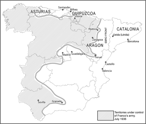
Fig. 1. Spain in July 1936, at the beginning of the Spanish Civil War, showing areas controlled by the Republican army and those held by General Franco's army. Madrid, with the Instituto Geográfico, the national mapping agency, remained in Republican hands until the end of the war in 1939. The unavailability of maps of Spain was a major logistic problem for the Francoist army.
The situation of Spanish cartography was exceptional in the European context. The general topographical map, the Mapa topográfico de España a escala 1:50.000, was entirely the responsibility of a civil organization, the Instituto Geográfico Catastral. Although publication had begun in 1875, only 564 of the projected 1,100 sheets had been published by the time the coup d’état occurred on 18 July 1936. However, the War Ministry, which was in charge of colonial cartography and maps of border zones, had already, in 1934, started its own production of a special military edition of the Mapa topográfico 1:50.000 on the Lambert projection and with a kilometric grid. A Plan Directeur on the French model, at the 1:25 000 scale, had also been initiated that year, based on the original material for the 1:50 000 map, by way of experiment. However, as may be anticipated, these tasks had scarcely progressed by 1936.Footnote 7
The transformation of the coup d’état of July 1936 into a large-scale war presented an enormous challenge to the heads of the cartographic services. The official mapping agencies stayed loyal to the government of the Republic, since Madrid remained in Republican hands until the end of the war. The Republican government was thus able to make use of published and unpublished maps available in the civil and military depositories. It also had at its disposal the capacity of its own institutions to produce maps. This meant that throughout the war, the Republican government could rely on a good cartographic service to publish topographical sheets at the scales needed for the different kinds of combat operations.Footnote 8 Nevertheless, it too had to face the challenge of mapping entire regions of the country for which no cartographical base map was available.
The Francoist army, in contrast, had to organize new cartographic services from scratch, and it was always at a cartographic disadvantage. At the outbreak of war, it started by making use of commercial French Michelin road maps, before resorting to various means to obtain maps, which even then were often deficient. The first step was to obtain copies of the official Spanish maps. Most of these were provided by the German army. Then, technical means for starting map production in large quantities had to be organized. Under the circumstances, foreign help played a crucial role. The well-equipped and well-trained Italian cartographers of the Istituto Geografico Militare were an invaluable support for General Franco's army.
In this article, we describe the cartographical assistance provided by the Italian cartographers.Footnote 9 In the early months of civil war, help came through the mass reproduction of some sheets of the 1:50 000 map of Spain that had already been published, on which further work was carried out in Florence at the headquarters of the Istituto Geografico Militare. A few months later, urgency led to the creation of an Italian cartographic service based in Spain, within territory controlled by Franco. This service specialized in three types of work: mass publication of existing maps at different scales for all kinds of war needs; publication of new maps of Spanish territory based on the surveying standards of Italian cartography; and the use of aerial photographs to obtain data, a technique which was subsequently widely used in the Second World War.
Maps for the Front
Between December 1936 and February 1937, Mussolini sent the Corpo Truppe Volontarie, a contingent of some 50,000 men, to Spain. In a report dated 16 November 1936, General Mario Roatta (1887–1968), the commander of the Italian expeditionary force, gave a complete description of the situation of the Francoist forces and of their equipment. His appraisal regarding the supply of cartographic material made the situation quite clear: ‘suffice it to say that there are no topographical maps, and practically no map is available at General Headquarters to this day, other than the “Michelin” road map at 1:400 000 scale’.Footnote 10
In those critical conditions, the Italian Istituto Geografico Militare became the first centre of cartographical publishing at the service of General Franco. The initial task was to reproduce maps of Spain in Florence. The technique used was to prepare printing plates from the negatives of photographic copies, even though the result was a monochrome map of poor quality. The first order was to print a minimum of one thousand copies of 380 different sheets from the 1:50 000 Mapa topográfico de España and 16 sheets from the 1:200 000 Mapa Militar Itinerario de España.Footnote 11 The two projects required more than four months of work.
We have not succeeded in discovering the exact date on which the order was given to start production of these maps. Whenever it was, on 5 February 1937, the Military Information Service indicated that a certain number of sheets of the maps at the 1:50 000 and 1:200 000 scales had already been dispatched to Spain.Footnote 12 Ten days later, the Istituto Geografico Militare, responding to a request from the General Staff of the Italian Ministry of Aeronautics, also printed several copies of an 1:1 000 000 Aeronautical Map of the Iberian Peninsula on the Mercator projection, which were sent to the War Ministry.Footnote 13 It was, naturally, a map requested by Italian aviators serving in Spain.
In the same month, the Corpo Truppe Volontarie asked the Military Information Service to produce, with the ‘utmost urgency’, 1,000 copies of all the sheets of the Michelin 1:400 000 map of Spain, which was at the time the best road and general map covering the whole of Spain.Footnote 14 We do not know if the Military Information Service passed this order on to the Istituto Geografico Militare or to another cartographic agency. In the event, this new order was immediately accepted in Rome, with production time being specified as 15 days and the cost, at 3.50 lira per copy, high because the map was to be in three colours. On 30 April, the Military Information Service announced that printing of the Michelin road map of Spain had been completed and the sheets were ready for dispatch.Footnote 15
Thus, from December 1936 to May 1937, the Istituto Geografico Militare in Florence, and eventually the Military Information Service, acted as map production units for the Francoist army. From May onwards, the collaboration offered by Italy acquired a new character with the decision to send a cartographic unit, the Sezione Topocartografica, to Spain to be attached to the Corpo Truppe Volontarie.Footnote 16 The following section deals with this unit's formation.
Corpo Truppe Volontarie Cartographic Unit
The creation of the Sezione Topocartografica was the direct result of the blow suffered by the Italian troops at the battle of Guadalajara, near Madrid, in March 1937 ().Footnote 17 After the defeat of the fascist army at Guadalajara, where the Corpo Truppe Volontarie had deployed more than 40,000 men and a large quantity of heavy equipment, the Italian troops were thoroughly reorganized, and reinforcements and new logistic services were requested from Rome.
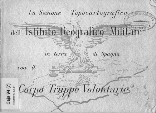
Fig. 2. Cover of La Sezione Topocartografica dell’ Istituto Geografico Militare in terra di Spagna con il Corpo Truppe Volontarie (Florence, IGM, 1939). The Italian volunteer corps of cartographers was sent to Spain by Benito Mussolini in winter 1936–1937 to create maps for the Francoist army as well as for Italians engaged on Franco's side in the Spanish Civil War. At the end of the war, the corps commemorated its cartographic achievements with this book. (Reproduced with permission from the Instituto Geográfico Nacional, Madrid.)
On 19 April 1937, General Doria, commander-in-chief of the Corpo Truppe Volontarie, asked the War Ministry to send a support unit to Spain, destined ‘to attend to all matters concerning cartography, which is in special difficulties, since the Spanish Cartographic Institute in Madrid has remained in red hands’.Footnote 18 The new unit was to be provided with drawing materials and the printing equipment needed to enable autonomous action on Spanish territory. On 13 May, the High General Staff in Rome ordered the Istituto Geografico Militare to go ahead with the immediate organization of a cartographic team, comprising three officials and ten specialists, to go to Spain. The personnel involved had to belong to the Istituto Geografico Militare and had to be volunteers. The sum envisaged for acquiring equipment amounted to 200,000 liras.Footnote 19
The new section was placed under the charge of Major Pietro Dossola, a veteran cartographer and an energetic man with war-zone experience. Born in 1887, he had entered the infantry as an officer in 1915. In 1926, with the rank of captain, he had taken part in topographical operations carried out by the Italian army in Libya.Footnote 20 After four years in Africa, during which he was promoted to commander, he returned to Florence to assume the direction of the Istituto Geografico Militare's School of Topography.Footnote 21 As a military cartographer Dossola had participated in surveying the Italian border with France and Austria, and in 1936 he was in charge of the topographical campaign of the Istituto Geografico Militare in the Tuscan-Emilian Apennine zone.Footnote 22 While in Spain as head of the cartographic section, Dossola was promoted to lieutenant-colonel.
Those who were to accompany Dossola to Spain were selected by Brigadier-General Toraldo di Francia, sub-director of the Istituto Geografico Militare. Two military cartographers, lieutenants Andrea dell'Osso and Alberto Massa, were chosen. The civilian technical staff included two draughtsmen, Guglielmo Coucourde and Natale Gabici; two specialists in photozincography, Aldo Balducci and Renato Frullini; a lithographic machine operator, Gino Renai; and a photographer, Gino Palchetti.Footnote 23 To print maps, the Sezione Topocartografica also required specialists in the preparation of zinc plates, but the military institute in Florence lacked such craftsmen, and they had to be found elsewhere. Thus, two civilian Italian engravers, Giovanni Campanella and Luigi Manzani joined the cartographic team.Footnote 24 Once in the Iberian Peninsula, the warrant officers Ruggero de Paoli, Maurizio Pipenni and Carlo Naso from the Corpo Truppe Volontarie were added to the cartographic unit.
On 19 May 1937, the cartographic team set sail from Genoa on the Brunner. A week later they disembarked in Spain, with part of their equipment weighing more than 70 tons. The Sezione Topocartografica was then set up in the music conservatory in Vitoria, northern Spain. The choice of this city was not arbitrary. Vitoria had been established as the centre for the cartographic services of the Francoist army in the spring of 1936 by Staff Colonel Dario Gazapo Valdés.Footnote 25 Given the proximity of the paper mills of Guipúzcoa, it was relatively easy to obtain supplies of paper. Within the city of Vitoria itself, moreover, local companies specializing in graphic arts, such as the printer Heraclio Fournier, were able to deal with the lithographic print runs of the maps.
Immediately on arrival in Vitoria, and while the equipment was being set up, Major Dossola applied for an increase in personnel. Specifically, he asked Rome to send the topographer Giorgio di Vecchio, a civil servant attached to the Istituto Geografico Militare, and three more military topographers. Dossola's application was not well received in Florence, and on 23 June 1937, the director of the Istituto Geografico Militare, the Division General R. Bianchi d'Espinosa, wrote to the War Minister informing him that the requested increase appeared excessive in view of the cartographic section's anticipated commitments.Footnote 26 Nevertheless, he had reluctantly to accept Dossola's request. On 25 June, he announced the posting to Spain of the senior topographer Giorgio di Vecchio and captains Gaetano de Meo and Ugo Campini. These men were not to be the last reinforcements for, in February 1938, the photographer Niccolò Drigani and the draughtsman Mario Silipigni, both again from the Istituto Geografico Militare, were posted to Vitoria with the specific mission of producing photographic mosaics and panoramic sketch maps of enemy positions.Footnote 27 The cartographic section of the Corpo Truppe Volontarie eventually consisted of twenty specialists ().
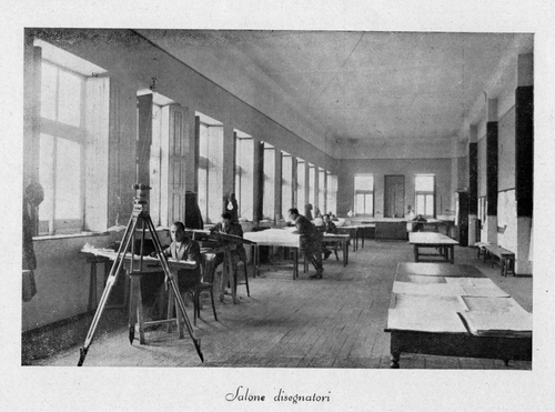
Fig. 3. The Sezione Topocartografica of the Italian Corpo Truppe Volontarie established a base in Spain in the northern city of Vitoria containing the drawing office shown here, a photographic studio, and a printing department. From La Sezione Topocartografica dell’ Istituto Geografico Militare in terra di Spagna con il Corpo Truppe Volontarie (Florence, IGM, 1939) (Reproduced with permission from the Instituto Geográfico Nacional, Madrid.)
The material and equipment required for the unit's operations were more difficult to assemble than the personnel. The cartographic section comprised three different services: drawing, photography and engraving, and printing. The photo-technical service was equipped with an 80 × 80 cm photographic camera that had been acquired in Milan. Printing necessitated a rotary press able to handle large sheets (the format was 70 × 95 cm). This press was purchased second-hand and was ready to be dispatched from Florence on 30 June 1937.Footnote 28 Its assembly and adjustment were left to artillery captain Giuseppe Tonini, who travelled to Vitoria with it and who remained attached to the cartographic section for more than two months. In addition to all the machinery, a wide range of material required for engraving and printing also had to be sent from Italy: photographic plates and paper, zinc plates, waxed cloth, and a large quantity of chemicals. The Istituto Geografico Militare supplied all the material needed by the cartographic section stationed in Spain almost to the end of the war.Footnote 29
The Cartographic Work
Aerial photography had already been found to be an effective mapping instrument in the First World War, and the ability to obtain up-to-date information about enemy territory from photographs would prove decisive in the Second World War. In the interval, Germany, Italy and Japan made numerous advances in photographic applications for military use. When the Spanish Civil War started, and parts of the country still lacked printed topographical maps at the 1:50 000 scale, aerial photography supplied what was lacking. While valuable unpublished cartography remained under the control of the Republican government, photography became a key element in cartographic production for General Franco's army.Footnote 30
As noted, one of the special services of the Sezione Topocartografica of the Corpo Truppe Volontarie was photography. By this was meant, on the one hand, the use of photographic techniques in the production of printed maps and, on the other, the use of aerial photographs in a number of cartographic assignments. It is to the latter that we now turn.
Aerial photographs constituted the main means of acquiring territorial data for the Italian cartographers in Spain. To this end, they had the collaboration of experienced pilots from the Italian Comando Aviazione Legionaria who continued to improve their equipment and skills throughout the war. The cartographers also probably had access to photographs taken by the German Condor Legion, as well as from Francoist pilots.Footnote 31 Both vertical and oblique aerial photographs were used in the photographic mosaics destined for the identification of targets and the updating of topographical cartography. Ground-level photographs were used in the drawing of panoramas and panoramic sketch maps, essential documents for locating enemy positions and key tools for the advanced troops’ artillery.
Photographic Mosaics
The assemblage of photographic mosaics from consecutive aerial photographs was a vitally important compensation for the acute lack of topographical data for areas of operations and battle sites. The tasks of identifying enemy targets and planning aerial bombardments were carried out on this type of cartographical document. Many mosaics were made of the northern and eastern fronts. These were at or above the scale of 1:10 000, covered relatively large extensions of territory, and were often annotated with the names of settlements and the destination of main roads. North was indicated, and the scale and the average altitude of the flight and the names of the pilot and navigator were given. Some mosaics, such as that covering the entire ‘iron belt’, or defensive line, of the city of Bilbao in northern Spain, are more than two metres long. Some of those preserved in the archives also have handwritten notes indicating the targets to be bombed ().
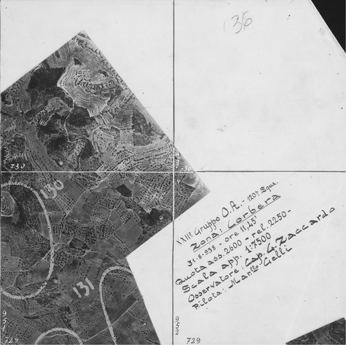
Fig. 4. The Corpo Truppe Volontarie made intensive use of aerial photography in the planning of air raids. Detail of a photographic mosaic of Corbera d'Ebre, Catalonia, at the approximate scale of 1:7 500, compiled from photographs taken at 11.45 AM on 31 August 1938 and marked up in red crayon (highlighted). The village was completely destroyed by a German air raid the following day and has been kept in its ruined state as a war memorial. 76 × 105 cm. (Reproduced with permission from the Institut Cartogràfic de Catalunya. Cartoteca, Fons Monés, RM.209.583.)
Vertical aerial photographs were also used by the Italian cartographic office in Spain to update topographical cartography, notably some of obsolete sheets of the 1:50 000 map covering the war zones. Of particular interest was the information on lines of communication derived from the aerial photographs. When the old map sheets had been thus updated, they were printed and distributed to the combat units.
The lack of topographical data was so worrying that surveys by photogrammetric restitution was seriously considered. This method of mapping inaccessible territory from two sets of air photographs, vertical and oblique, coordinated to create a model of the terrain and from which directions and angles can be measured for mapping topographical data in general and targets in particular was proposed for the Asturias region on the north coast of Spain for which no topographical map existed. No sheets of the Mapa topográfico de España 1:50 000 for this region had been printed before 1936. While the Republican army had the manuscript surveys of the area made before the start of the war, the Francoist army lacked all topographic data for this zone, which remained in Republican hands, and it urgently needed maps to prepare the attack.
In July 1937, Franco's army suggested to the chief of the Italian topographical section the possibility of a topographical survey of one part of this mountainous region of the Cantabrian coast.Footnote 32 The commanding officers of the Francoist army had heard of the Stereosimplex I, an instrument created by Ermenegildo Santoni (1896–1970) of the Officina Galileo of Florence, a company that supplied technology to the Istituto Geografico Militare.Footnote 33 The apparatus had been designed exclusively for military use and was easy to dissembled, transport and re-assemble. Major Dossola immediately transmitted the request to the Istituto Geografico Militare in Florence and proposed to set up the Stereosimplex in his technical office in Spain, where he already had skilled personnel capable of operating the equipment, with which he was familiar from a similar project in the Abyssinia campaign. Despite the support of the Italian government, who regarded the project as an opportunity to gain prestige for Italian science, the Istituto Geografico Militare decided not to carry out the project partly because, as summer was drawing to a close, the increased risk of cloud cover was likely to reduce the quality and coverage of data capture.Footnote 34 Major Dossola did not, however, abandon the idea of photogrammetric restitution in Spain and, a year later, he presented another project ‘in case the occasion arises to carry it out’.Footnote 35 But the opportunity did not arise.
Panoramic Sketch Maps and Views
The other photographic application that occupied the Italian cartographers posted to Spain was the well-known technique of representing terrain in panoramic views to complement and facilitate terrain identification.Footnote 36 Panoramic sketch views are featured in all military handbooks of cartography, since reading them requires no special knowledge of cartographical practice, and they are a highly effective tool for recording reconnaissance at the front. In the Spanish Civil War, panoramic sketches were used by both sides involved in what was essentially a war of positions.Footnote 37 These perspective drawings, showing the terrain and indicating enemy positions and other features of potential military interest, were extremely useful for advancing artillery and troops.
The arrival of photography allowed a manuscript drawing to be replaced by a photograph or group of photographs to create panoramas, a technique already employed in the First World War ().Footnote 38 The photographs, however, were often found to be a poor substitute for field drawings, since they failed to highlight features of military interest, and annotated photographs had to be forwarded to the topographical section responsible for the production of sketch maps.
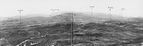
Fig. 5. Photographic panoramas, created by the Corpo Truppe Volontarie, Sezione Topocartografica, were annotated with points of interest, such as enemy positions, as in this panorama of Soncillo, Burgos, in central Spain. 15 × 69 cm. (Reproduced with permission from the Institut Cartogràfic de Catalunya. Cartoteca, Fons Monés, RM.209.762.)
The stagnation of some war fronts, often for several months, encouraged panoramic sketching. Opposing units had time to observe and draw the layout of enemy trenches and indicate, among other things, the number and calibre of the enemy's artillery pieces. The Italian cartographers produced numerous maps from such panoramas, using both photographs and field drawings. Depending on the urgency and nature of the military need, they created several different types of panoramas.
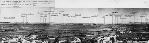
One kind of panorama was made by assembling a sequence of photographs annotated with only basic toponymy or a compass direction. According to the Sezione Topocartografica, about a hundred photographic panoramas were produced, mostly for the north, centre (Madrid), and Ebro fronts. During the stalemate of the Ebro front, which remained static for nearly a year, twenty-two of these panoramas were put together to cover the whole zone from Huesca to near Teruel, a straight-line distance of more than 150 kilometres ().
Fig. 6. Photographic panoramas were used in the daily check on enemy positions, as well as for recording important landscape features. The views in this panorama of part of the Ebro front were taken from the bell tower of Huesca cathedral in 1937. Places with a single underline were rosso, that is Republican positions. Double underlining marked Francoist locations. 16 × 73 cm. (Reproduced with permission from the Institut Cartogràfic de Catalunya. Cartoteca, Fons Monés, RM.209.648.)
Other panoramas were created from drawings of the terrain, which was first outlined on the photographs and then traced on transparent drawing paper and coloured (). This was the delineation process in which the Italian work stood out for its artistic quality (). Footnote 39 Then, especially for the most static fronts, the finished drawing might be printed. As troop positions changed, their movements would be recorded on the printed view, which thus allowed easy updating of the enemy situation. Some 35,270 copies of an unknown number of different panoramas produced in this way were printed, a substantial figure that demonstrates the importance of this form of war-time mapping.Footnote 40 Undoubtedly, the production of maps and panoramas from photographs taken from the air and at ground level was a highly effective method of primary-data capture. It was a fundamental part of the work of the Italian cartographic section in Spain, and would be widely used in the Second World War.
Plate 3. Schizzo panoramico dall'oss[ervatorio] (Km. 304 Strada di Gandesa). The Ebro front line was static for much of 1938. The stalemate allowed both sides time for field sketching and the drawing of further panoramas indicating enemy positions. Shown here is a manuscript panoramic sketch of the area near Gandesa, Catalonia, made by the Comando Artghliero of the Corpo Truppe Volontarie. 21×84 cm. Republican positions are indicated in red, Francoist in blue. The numbers in red on the Republican side indicate the positions of their batteries, those in black give altitude (Ital. quota) in metres. The enlarged detail is taken from right of centre. (Reproduced with permission from the Institut Cartogràfic de Catalunya. Cartoteca, Fons Monés, RM.271.630.)
![Plate 3. Schizzo panoramico dall'oss[ervatorio] (Km. 304 Strada di Gandesa). The Ebro front line was static for much of 1938. The stalemate allowed both sides time for field sketching and the drawing of further panoramas indicating enemy positions. Shown here is a manuscript panoramic sketch of the area near Gandesa, Catalonia, made by the Comando Artghliero of the Corpo Truppe Volontarie. 21×84 cm. Republican positions are indicated in red, Francoist in blue. The numbers in red on the Republican side indicate the positions of their batteries, those in black give altitude (Ital. quota) in metres. The enlarged detail is taken from right of centre. (Reproduced with permission from the Institut Cartogràfic de Catalunya. Cartoteca, Fons Monés, RM.271.630.)](/cms/asset/c37fe16b-de93-45b8-ac9d-9c127ad761fb/rimu_a_621399_o_f0011g.jpg)
![Plate 3. Schizzo panoramico dall'oss[ervatorio] (Km. 304 Strada di Gandesa). The Ebro front line was static for much of 1938. The stalemate allowed both sides time for field sketching and the drawing of further panoramas indicating enemy positions. Shown here is a manuscript panoramic sketch of the area near Gandesa, Catalonia, made by the Comando Artghliero of the Corpo Truppe Volontarie. 21×84 cm. Republican positions are indicated in red, Francoist in blue. The numbers in red on the Republican side indicate the positions of their batteries, those in black give altitude (Ital. quota) in metres. The enlarged detail is taken from right of centre. (Reproduced with permission from the Institut Cartogràfic de Catalunya. Cartoteca, Fons Monés, RM.271.630.)](/cms/asset/73a52c85-1597-4cd3-99e3-277ae1f8f1cd/rimu_a_621399_o_f0012g.jpg)
Plate 4. Schizzo panoramico dall'oss[ervatorio] della II Battery. Str[ada] in Amposta, southern Catalonia. Manuscript panoramic sketch map indicating Republican positions, made by Italian troops of Comando Frecce [Arrow Command] in the Spanish Civil War, near the village of Amposta on the Ebro River. The river is coloured blue, and farm tracks of particular interest are highlighted in red. As seen in the enlargement, the suspension bridge is labelled as destroyed and the altitude of Casa La Portella (q. 486) is given. 23×72 cm. (Reproduced with permission from the Institut Cartogràfic de Catalunya. Cartoteca, FonsMonés, RM.209.566.)
![Plate 4. Schizzo panoramico dall'oss[ervatorio] della II Battery. Str[ada] in Amposta, southern Catalonia. Manuscript panoramic sketch map indicating Republican positions, made by Italian troops of Comando Frecce [Arrow Command] in the Spanish Civil War, near the village of Amposta on the Ebro River. The river is coloured blue, and farm tracks of particular interest are highlighted in red. As seen in the enlargement, the suspension bridge is labelled as destroyed and the altitude of Casa La Portella (q. 486) is given. 23×72 cm. (Reproduced with permission from the Institut Cartogràfic de Catalunya. Cartoteca, FonsMonés, RM.209.566.)](/cms/asset/d33afc2e-d008-40a8-878e-5c3ab848c9f3/rimu_a_621399_o_f0013g.jpg)
![Plate 4. Schizzo panoramico dall'oss[ervatorio] della II Battery. Str[ada] in Amposta, southern Catalonia. Manuscript panoramic sketch map indicating Republican positions, made by Italian troops of Comando Frecce [Arrow Command] in the Spanish Civil War, near the village of Amposta on the Ebro River. The river is coloured blue, and farm tracks of particular interest are highlighted in red. As seen in the enlargement, the suspension bridge is labelled as destroyed and the altitude of Casa La Portella (q. 486) is given. 23×72 cm. (Reproduced with permission from the Institut Cartogràfic de Catalunya. Cartoteca, FonsMonés, RM.209.566.)](/cms/asset/993089a3-f862-46de-bccd-638cd7ef7f27/rimu_a_621399_o_f0014g.jpg)
Drawing and Printing of Maps
Maps at the 1:50 000 Scale
As with any other large military unit, the Corpo Truppe Volontarie needed three different types of map: large-scale maps for tactical use (1:25 000 or 1:50 000), command maps for strategic direction (usually at 1:100 000), and road maps (at 1:200 000 and 1:400 000). We have already mentioned that from late 1936 the Istituto Geografico Militare assumed the task of printing a considerable array of sheets of the Mapa topográfico de España at a scale of 1:50 000, destined for the Italian troops. The Mapa topográfico de España, which was still unfinished at the start of the war, had the same scale and projection as the Italian topographical map (Carta topografica d'Italia alla scala 1:50.000), with which officers of the Corpo Truppe Volontarie were familiar. Unlike the Spanish map, however, the Italian map used a geographical grid divided into minutes, with border letters to designate the squares. The Spanish maps had no superimposed military grid, and this shortcoming, together with the illegibility of the Spanish map, when printed in monochrome, as a result of an over-abundance of information on land use, persuaded those in charge of the Sezione Topocartografica to redraw completely some sheets of the 1:50 000 map of Spain.
As redrawn by the Italian cartographers, the new Spanish sheets are clear and legible. They give an overall impression of a map in ‘Italian’ style. The emphasis was on lines of communication, classified here in accordance with the Istituto Geografico Militare's norms for conventional signs. The planimetry eliminated most land-use markings, retaining only those indicating areas covered by trees. Altitude was shown by contour lines at twenty metre intervals. Labelling was in the same typeface as that used on Italian topographical maps. Marginal information was considerable. The lower margin included a complete table of conventional signs in Italian, and the upper margin contained the title of the sheet and its number. In the course of redrawing, the planimetry was updated on some sheets from aerial photographs. The orthogonal geographical grid typical of Italian military cartography was overlaid on all sheets. Since some sheets were also to be used by Spanish troops, a second grid, printed in red with kilometric divisions, was superimposed ().
Fig. 7. Details from two editions of the ‘Guadalajara’ sheet (38 × 57 cm) of the 1:50 000 map of Spain, both printed in 1937. Above, the map made by Franco's army in Spanish style; below, the Italian Corpo Truppo Volontarie's version, in their own style. Note the emphasis on lines of communication, the simplicity of land-use markings. The Italian version contains a complete table of conventional signs on the Italian style sheet. (Reproduced with permission from the Cartoteca de Catalunya, RM. 251.958; and a private collector.)
The Sezione Topocartografica redrew and published a total of sixty sheets. These fall into three geographical groups covering the Santander, Madrid and Ebro fronts. The first sheets to be printed correspond to the zone where the 1937 offensive, aimed at the taking of Bilbao and Santander, was to be launched. The maps were produced with extraordinary speed during the summer of 1937, under particularly difficult circumstances: they had to be created from heterogeneous, barely appropriate sources, since the Spanish Instituto Geográfico Nacional had not yet published most of the relevant sheets. From the military point of view, some of these maps were simply poor, being little more than sketches with incomplete altimetric information. Yet even such sketches were of crucial importance given the lack of more detailed cartography. By the end of June 1937, the Corpo Truppe Volontarie already had printed copies of sheets 34 (Torrelavega), 35 (Santander), and 58 (Los Corrales de Buelna) at its disposal, and the cartographic section printed an additional run of one thousand copies destined for Franco's General Headquarters in Burgos.
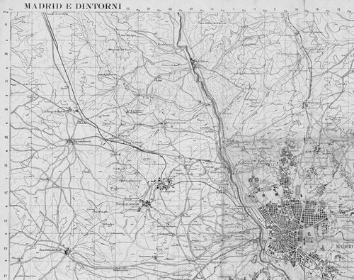
Between October and December 1937, the Italian cartographers worked on a group of a dozen sheets covering Madrid and surrounding areas. In this case, the revision was fairly careful, involving the use of aerial photographs sent by the Italian Comando Aviazione Legionaria.Footnote 41 A sheet named Madrid e dintorni [Madrid and surroundings] was prepared with special care (). It was printed in winter of 1937 in five colours in a 59 × 79 cm format and included parts of the adjoining sheets as an overlap. On 11 December 1937, Pietro Dossola notified Florence that the printing machine was working ‘day and night’ to achieve a total run of 25,000 copies of the sheets of the Madrid front so that ‘all platoon commanders and all patrol chiefs have the map of the zone at their disposal’.Footnote 42
Fig. 8. Detail from Madrid e dintorni, a special production in five colours on the scale of 1:50 000 (59 × 79 cm) printed in December 1937 by the Sezione Topocartografica in preparation for an attack by the Francoists on the Spanish capital. The map was based on aerial photographs and is highly accurate. The attack was never carried out, and at the end of the war Madrid surrendered to the Francoists. (Reproduced with permission from the Institut Cartogràfic de Catalunya. Cartoteca, Fons Monés, RM.209.757.)
The Corpo Truppe Volontarie, however, was not destined to enter combat in Madrid. In spring of 1938, it was posted to the Ebro front in Aragon. To accommodate the needs of this front, the cartographic section drew and printed a large group of sheets covering the central part of the Ebro valley, and a few sheets covering southern Catalonia. On 26 March 1938, Dossola informed Lieutenant Colonel Giacomo Zanussi, vice-chief of the General Staff of the Corpo Truppe Volontarie, that he was working on the redesign of sheets 470 (Gandesa) and 496 (Horta de San Juan) and that, once these had been finished, he would proceed to redraw sheets 471 (Mora de Ebro), 497 (Perelló) and 522 (Tortosa).Footnote 43
In late 1938, the fascist army planned an offensive against Catalonia, one of the last resistant zones of the Spanish Republican army. Compilation of the Italian series was almost abandoned as the Italians stopped publishing their Carta della Spagna and concentrated their efforts on reinforcing the production capacity of the cartographic services of Franco's General Headquarters, which suffered from a lack of reprographic facilities. During military operations in Catalonia, the Italian cartographic section printed 70,000 copies of the Spanish 1:50 000 scale map. Franco's cartographers also tried to create new maps by reducing the 1:50 000 topographical map, notably the Mapa de Mando [Command Map] at the scale of 1:100 000. However, the Corpo Truppe Volontarie considered that, since sheets on the scale of 1:50 000 and 1:200 000 were available, an intermediate scale was relatively superfluous and production of the 1:100 000 map was limited.
Maps at the 1:200 000 Scale
In the course of the war, the Italians gave priority to the 1:200 000 map, since Spanish military cartography at this scale was clearly deficient. By September 1937, they had already decided to compile a new map at that scale, to be published in polychrome and to show relief by means of contour lines at one hundred metre intervals with hypsometric tinting. The map was to be derived from the 1:50 000 topographical map, but on a sheet format of 81 × 56 cm, the maximum size accepted by the available printing equipment. Each sheet of the 1:200 000 map would thus cover thirty-six sheets of the 1:50 000 map and represent a ground area measuring one degree latitude by two longitude. The sheets were to incorporate a geographical grid of 10 minutes of latitude by 20 minutes of longitude.
The shift from 1:50 000 to 1:200 000 made the process of cartographical generalization essential. The procedure adopted to create this road map was as follows. First, cyanographic copies were made of each of the 1:50 000 map sheets, and information to be transferred to 1:200 000 scale was marked over in black. Then, the sheets were photographically reduced to 1:200 000 and the negatives printed on non-warping photographic paper (‘correctostat’) showing only the marked information. Once these preliminary tasks had been concluded, a mosaic composed from the reduced versions was photographed to form the 1:200 000 sheet.Footnote 44 Plates were then prepared from this mosaic for printing in colour, with black for the planimetric features, blue for the hydrographical, red for main roads, and sienna for relief.
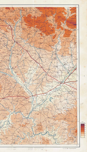
The publication of a hypsometrically tinted map at the scale of 1:200 000 was an integral element in the preparation of the Francoist offensive on the Ebro front. The attack on this area differed considerably from previous operations. The new mechanized military units proved a decisive force, and their advance was speedy. Significantly, Franco's army had, for the first time, well-prepared and relatively abundant cartographic resources at its disposal. Cartographic preparation for the offensive had started some months earlier. The first sheet of the road map, titled ‘Zaragoza–Lérida’, was published on 28 October 1937 after fifty days of feverish work (). Twelve more sheets followed, coming out in response to the most urgent needs or to the strategic forecasts of the Corpo Truppe Volontarie.
Plate 5. Detail from ‘Zaragoza–Lérida’, the first sheet of the road map at 1: 200 000 scale to be printed in 1937 by the Sezione Topocartografica. Relief is indicated by contours and hypsometric tinting (the seven-class scale is given in the margin). This was the preferred map series of the German air force for bombing Republican territory. (Reproduced with permission from the Institut Cartogràfic de Catalunya. Cartoteca, Fons Monés, RM.209.671.)
The Sezione Topocartografica worked day and night throughout February 1938 to prepare the ‘Teruel–Tortosa’ sheet, the first copies of which were handed to the commanders of the Corpo Truppe Volontarie on 7 March, only a few hours before the start of the campaign that was to culminate in the cutting of Republican lines at Castellón. In April and May 1938, the ‘Valencia’ and ‘Tarragona–Barcelona’ sheets were published. In both cases the Sezione Topocartografica worked against the clock, urged on by a General Staff predicting, without foundation, a rapid collapse of the Republican front. The remaining sheets, mostly relating to the central sector of Spain were prepared with less haste during the second half of 1938 and the first months of 1939.
The Italian 1:200 000 map was initially conceived as a road map. The effort involved in the correct representation of lines of communication primarily reflected the needs of motorized military units. In the event, it was used much more extensively by other units. On 15 November 1937, Colonel Wolfram von Richtofen, Chief of the General Staff of the Condor Legion, requested 250 copies of the ‘Zaragoza–Lérida’ sheet, declaring the 1:200 000 to be ‘the most perfect map to be found in Spain today’ and the only map that could be of use to his pilots ‘for information duties’.Footnote 45 Von Richtofen's interest in the Italian map is understandable. Although the flight-order plans were usually marked on the 1:50 000 map, the poor legibility of the monochrome sheets that were all that was available to Franco's army greatly reduced their usefulness for movement on the ground or for reconnaissance work. The German pilots, like their Italian counterparts, preferred the coloured sheets of the 1:200 000 map, which were unburdened by unnecessary topographical details, and which highlighted communication lines easily identifiable from the air.
The importance of the 1:200 000 map is indicated by its print run. This averaged slightly above 4,000 copies for each sheet, a substantial figure considering we are dealing with a map in colour, whose production cost was well above that of monochrome maps (). In fact, the print run of the road map far exceeded that of any of the other maps printed by the Sezione Topocartografica.
Fig. 9. Maps printed by the Sezione Topocartografica between May 1937 and April 1939.
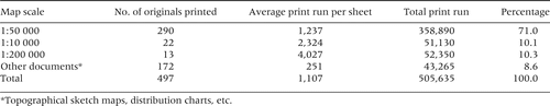
Altogether, the Sezione Topocartografica put a little over half a million printed map sheets on various scales into circulation. The majority, about 70 per cent, was accounted for by the 290 sheets of the 1:50 000 map (60 sheets of the Italian series, and 230 of a collection prepared by the Francoist topographical service). The remaining 30 per cent was divided, almost in equal parts, among the command map at 1:100 000, the road map at 1:200 000, and a heterogeneous group of documents that included the topographical sketch maps and panoramas, plots and graphs showing the geographical distribution of the sheets of various maps, and other minor items (). This considerable production is roughly equivalent to around 17 per cent of the total cartographic production of the cartographic services of Franco's army.Footnote 46 In general terms, the appearance and content of the Italian maps reflect greater care than those compiled by other cartographical services in Spain during the war.
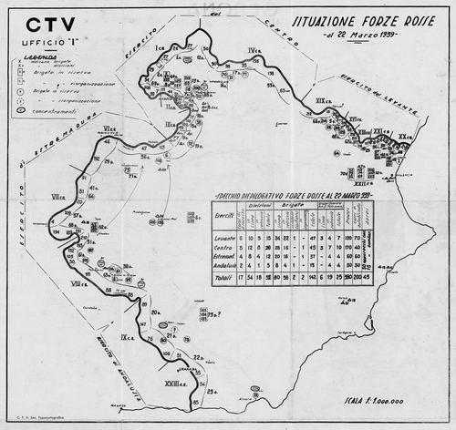
Fig. 10. Map showing the ‘Situation of the red troops on the 22 March 1939’, one week before the end of the war. By now the Republican army had been almost destroyed and the Sezione Topocartografica recorded the distribution and strength of the remaining brigades near Cartagena, on the Mediterranean coast. 87 × 92 cm. (Reproduced with permission from the Institut Cartogràfic de Catalunya. Cartoteca, Fons Monés, RM.209.431.)
The Spanish Civil War presented a scenario in which the existing cartographic services remained entirely in Republican government hands, leaving the Francoist army to find other means of acquiring the maps they needed. Mussolini gave Franco firm support in these cartographical matters. During the first phase of the war, the Italian Istituto Geografico Militare printed maps of Spain in Florence. Later, they installed an Italian cartographic survey unit in Spain, working for the Italian troops there as well as for Franco's army.
The activity of the Italian cartographers in the Spanish Civil War was both quantitatively and qualitatively significant. More than half a million copies of various sheets of Spanish maps were printed by the Sezione Topocartografica as well as by the Istituto Geografico Militare in Florence, and new cartographic techniques were improved, such as the preparation of mosaics from air photographs, and panoramic sketch maps from air and ground photographs. Some sheets of the 1:50 000 Mapa topográfico de España were effectively redesigned, and a multisheet road map on the scale 1:200 000 was created.
The Italian's cartographic support of the Francoist army, when its coup d’état turned into civil war, provided significant aid to the fascist troops and can be seen as a training ground for Second World War mapping methods. It also marked the internationalization of twentieth-century Spanish cartography.
Acknowledgements
Work for this article was carried out within the framework of the research project 2007 EBRE 2 financed by the Agència de Gestió d'Ajusts Universitaris i de Recerca de la Generalitat de Catalunya. We wish to thank Professors Vladimiro Valerio (University of Venice) and Aldo G. Ricci (superintendent of the Archivio Centrale dello Stato, Rome) for the information they provided. We are also indebted to Colonel Antonio Lucio Finizio and Lieutenant Giovanni Orrò (both of the Istituto Geografico Militare, Florence) and to the personnel of the Archivio dell'Ufficio Storico dello Stato Maggiore dell'Esercito, Rome.
Notes
NOTES AND REFERENCES
1. The bibliography on the relationship between war, geographical knowledge and cartography is extensive. Worth mentioning are recent works by Marie-Anne de Villèle, Agnès Beylot and Alain Morgat, Du paysage à la carte. Trois siècles de cartographie militaire de la France (Vincennes, Ministère de la Défense, 2002); David Buisseret, The Mapmakers’ Quest: Depicting New Worlds in Renaissance Europe (Oxford, Oxford University Press, 2003); Vladimiro Valerio, ‘L'occhio mutevole: militari e mappe tra rivoluzione e restaurazione’, in La cartografia europea tra primo Rinascimento e fine dell'Illuminismo, ed. Diogo Ramada Curto, Angelo Cattaneo and André Ferrand Almeida (Florence, Leo S. Olschki Editore, 2003), 229–44. See also Francisco Quirós and Juan Carlos Castañón, Madrid 1808. Guerra y territorio. Mapas y planos 1808–1814 (Madrid, Ayuntamiento de Madrid, 2008).
2. On the concept of the Plan Directeur and its introduction during the First World War, see Michael Bacchus, ‘L’établissement des plans directeurs pendant la guerre de 1914–1918’, in Villèle et al., Du paysage à la carte (note 1), 128–34.
3. Peter Collier, ‘The impact on topographic mapping of developments in land and air survey 1900–1936’, Cartography and Geographic Information Science 29:3 (2002): 155–74.
4. The bibliography on the Spanish Civil War is considerable. For a general view, see, for example, Anthony Beevor, La guerra civil española (Barcelona, Crítica, 2005). For military questions, see Gabriel Cardona, Historia militar de una guerra civil. Estrategias y tácticas de la guerra de España (Barcelona, Flor del Viento, 2006).
5. The internationalization of the Spanish Civil War is considered in Enrique Moradiellos, ‘The allies and the Spanish Civil War’, in Spain and the Great Powers in the Twentieth Century, ed. Sebastian Balfour and Paul Preston (London, Routledge, 1999), 96–126; and in Michel Alpert, Aguas peligrosas. Nueva historia internacional de la Guerra Civil Española, 1936–1939 (Madrid, Akal, 1998).
6. For the Italians in the Spanish Civil War, see John F. Coverdale, Italian Intervention in the Spanish Civil War (Princeton, Princeton University Press, 1975), with its Spanish translation La intervención fascista en la Guerra Civil española (Madrid, Alianza Universidad, 1979); Paul Preston, ‘Mussolini's Spanish adventure: from limited risk to war’, in The Republic Besieged. Civil War in Spain, 1936–1939, ed. P. Preston and A. L. Mackenzie (Edinburgh, Edinburgh University Press, 1998), 21–51; Paul Preston, ‘Italy and Spain in civil war and world war’, in Balfour and Preston Spain and the Great Powers in the Twentieth Century (see note 5), 151–84.
7. To understand the state of the Spanish topographical map before 1936, see Luis Urteaga and Francesc Nadal, Las series del Mapa Topográfico de España a escala 1:50.000 (Madrid, Instituto Geográfico Nacional, 2001); and Ángel Paladini Cuadrado, ‘Notas para la historia del Mapa Topográfico Nacional de España’, Militaria. Revista de Cultura Militar 3 (1991): 83–100.
8. The task of the republican cartographic services is related in Luis Urteaga and Francesc Nadal, ‘La sección cartográfica del Estado Mayor Central durante la Segunda República (1931–1936)’, Hispania (in press). For a general view of the cartography in the Spanish Civil War, see Carme Montaner, Francesc Nadal and Luis Urteaga, eds., Los mapas en la Guerra Civil española, 1936–1939 (Barcelona, Institut Cartogràfic de Catalunya, 2007).
9. Our study originated in the Monés Collection, a cartographic collection consisting of maps, aerial photographs, diagrams and some reports by the Corpo Truppe Volontarie, kept at the Cartoteca de Catalunya of the Institut Cartogràfic de Catalunya (Barcelona). All these materials are downloadable at http://cartotecadigital.icc.cat. We also made use of original documents preserved at the Archivio dell'Ufficio Storico dello Stato Maggiore dell'Esercito in Rome, Fondo Oltremare Spagna (hereafter ASME-FOS).
10. Report by General Roatta to the War Ministry, 16–17 November 1936. Reproduced in Alberto Rovihi and Filippo Stefani, La partecipazione italiana alla Guerra Civile Spagnola (1936–1939), 4 vols. (Rome, Stato Maggiore dell'Esercito, Ufficio Storico, 1992–1993), 4: I: 78.
11. On 21 December 1936, one day before the first Italian volunteers disembarked in Cadiz, the brigadier general Toraldo di Francia, sub-director of the Istituto Geografico Militare, compiled a report, at the request of the Italian Military Information Service of the Ministry of War, estimating the costs of, and time needed for, the redrawing and printing of these maps: the project anticipated more than 120 days’ work, with a preliminary month for the assembly of all necessary raw materials: photographic plates, acid, sheets of zinc, and paper. In fact, the work took five or six months from the start of production. The envisaged cost of preparing the plates was 60,000 liras. The printing costs estimated 0.60 lira per sheet, for the 1:50 000 map, and 1 lira for each sheet of the 1:200 000 map, provided a minimum of one thousand copies was made of each sheet. Letter from Toraldo di Francia to the War Ministry, 21 December 1936 (ASME-FOS (see note 9), F18, R47, 8).
12. The Colonel sub-chief of the Servicio de Información Militar, Angioj, to the War Ministry, Rome, 5 February 1937 (ASME-FOS (see note 9), F16, R47, 8).
13. R. Bianchi d'Espinosa to the War Ministry. Florence, 14 February 1937 (ASME-FOS (see note 9), F16, R47, 8).
14. Colli to the War Ministry. Cabinet, 1 February 1937 (ASME-FOS (see note 9), F18, R47, 8).
15. Colonel vice-chief of the Military Information Service to the War Ministry, 30 April 1937 (ASME-FOS (see note 9), F18, R40, 5).
16. The formation of the cartographic section of the Corpo Truppe Volontarie did not entirely end the Istituto Geografico Militare's activity in Florence as a publisher of Spanish maps. On 8 September 1937, Bianchi d'Espinosa announced to the War Ministry the start of a new run of maps of Spain ‘at a feverish pace’ (R. Bianchi d'Espinosa to the War Ministry, Florence, 8 September 1937 (ASME-FOS (see note 9), F18, R47, 8). On 19 October of the same year, notification came of the urgent printing of sheets 912, 913, 914, 934, 935 and 956 corresponding to the Topographical Map of Spain at 1:50 000 scale (Colonel Castellani to the War Ministry, Florence, 19 October 1937 (ASME-FOS (see note 9), F18, R40, 5).
17. For a preliminary note on the cartographical consequences of the battle of Guadalajara, see Luis Urteaga, Francesc Nadal and José Ignacio Muro, ‘La cartografía del Corpo di Truppe Volontarie, 1937–1939’, Hispania (Madrid) 62:1 (2002): 283–98.
18. General Doria to the War Ministry, April 19th 1937 (ASME-FOS (see note 9), F18, R40, 5).
19. See also Cuartel General del Generalísimo. Estado Mayor. 5a sección, Memoria del Servicio Cartográfico Militar. Campaña 1936–39 (Burgos, May 1939), signed by Comandante de Estado Mayor, Jefe de la Sección, Carmelo Medrano. Typescript preserved at Centro Geográfico del Ejército in Madrid; Istituto Geografico Militare, La Sezione Topocartografica dell'Istituto Geografico Militare in terre di Spagna con el Corpo Truppe Volontarie, Vitoria, maggio 1937–aprile 1939. Anno de la Vittoria (Florence, Istituto Geografico Militare, 1939).
20. Carlo Traversi, Storia della cartografia coloniale italiana (Rome, Istituto Poligrafico dello Stato, 1964); Istituto Geografico Militare, L'Istituto Geografico Militare in Africa Orientale, 1885–1937 (Florence, Istituto Geografico Militare, 1939).
21. Pietro Dossola, Promemoria, October 12th 1937 (ASME-FOS (see note 9), F18, R40, 5).
22. Pietro Dossola, ‘I rilevamenti topografici dell'I.G.M. sull'Appennino Tosco-Emiliano’, L'Universo (Florence) 18:5 (1937): 1–11.
23. Report of the Istituto Geografico Militare to Comando Corpo S. M., May 17th 1937 (ASME-FOS (see note 9), F18, R40, 5).
24. Head of the Gabinete del Ministero della Guerra to the Ministero degli Affari Esteri. Rome, May 21st 1937 (ASME-FOS (see note 9), F18, R40, 5). Envisaged payment for Giovanni Campanella and Luigi Manzini was 80 liras per day.
25. Luis Urteaga, ‘La cartografía del ejército franquista (1937–1939)’, in Montaner et al., Los mapas en la Guerra Civil (see note 8), 47–81.
26. ‘It should not be forgotten’, wrote Bianchi d'Espinosa, ‘that the maps already exist [in Spain], so that rather than genuine topographical operations (on the other hand impossible to carry out in enemy territory), these are modest cartographical tasks of various types, and minor operations of assistance to the artillery’. Report of R. Bianchi d'Espinosa to the War Minister, 23 June 1937 (ASME-FOS (see note 9), F18, R40, 5).
27. Brigadier General O. Toraldo di Francia to the War Ministry, 15 February 1938 (ASME-FOS (see note 9), F18, R40, 5).
28.R. Bianchi d'Espinosa to the War Ministry, 30 June 1937 (ASME-FOS (see note 9), F18, R40, 5).
29. The initial shipment included fifty 70 × 100 cm sheets of zinc, 10 kg sodium bisulphate, 10 kg potassium carbonate, and a quantity of photographic plates and printing paper which we have been unable to determine. This supply soon proved to be insufficient. We have found requests for additional material, analogous to those already cited, dated 2 September and 7 November 1937, 10 February 1938, and 8 March 1938 (ASME-FOS (see note 9), F18, R40, 5).
30. Carme Montaner, Francesc Nadal and Luis Urteaga, ‘El servicio de cartografía de la Confederación Hidrográfica del Ebro durante la guerra civil española’, Boletín de la Asociación de Geógrafos Españoles 52 (Madrid, 2010): 273–94.
31. Felipe Fernández, ‘Aerial photography in the Spanish Civil War’, in Montaner et al., Los mapas en la Guerra Civil (see note 8): 84.
32. Major Pietro Dossola to the Directive of the Istituto Geografico Militare, 13 July 1937 (ASME-FOS (see note 9), F6, RN3).
33. Ermenegildo Santoni is the author of more than 40 patent applications for photogrammetric devices and aerial-photography cameras. From 1918 he was employed by the renowned Galileo Company, founded in 1866 for the production of scientific instruments but working up to the end of World War II mainly as a military industry. See K. B. Atkinson, ‘Ermenegildo Santoni (1896–1970)’, in Photogrammetric Record 8:46 (1996): 615. Manual of Photogrammetry, edited by the American Society of Photogrammetry (New York and Chicago, Pitman, 1944).
34. Istituto Geografico Militare, Directive to Major Cav. Pietro Dossola, Florence, 10 August 1937 (ASME-FOS (see note 9), F6, RN39).
35. Report of Lt. Col. Commander of the Topographical Section of the CTV Pietro Dossola of 3 September 1938 (ASME-FOS(see note 9), F6, RN39).
36. A number of manuals in Spanish dealing with sketch mapping had been available in print from the beginning of the century. See, for instance, Luis Gonzalez de la Vera, El croquis panorámico: aplicaciones militares del dibujo del paisaje (Burgos, Imprenta de Marcelino Miguel, 1912).
37. The Military Archive of Ávila contains a large number of panoramic sketch maps made by the armies taking part in the Spanish Civil War. They now constitute valuable documentation for the study and evolution of landscape.
38. See Bacchus, ‘L’établissement des plans directeurs pendant la guerre de 1914–1918’ (note 2).
39. The Monés Collection contains some manuscript panoramic sketch maps signed by ‘Suñé’ which go beyond the cartographic document and constitute a work of art (Montaner et al., Los mapas en la Guerra Civil española (see note 8), 64).
40. La Sezione Topocartografica dell'Istituto Geografico Militare in terre di Spagna (see note 19), 133.
41. M. Garda, Comandante General Divisione Aerea. Comando Aviazione Legionaria to Comandante del C.T.V., 9th December 1937 (ASME-FOS (see note 9), F18, R40, 5).
42. Lieutenant Colonel Pietro Dossola to General Bianchi d'Espinosa, 11 December 1937 (ASME-FOS (see note 9), F18, R40, 5).
43. Lieutenant Colonel Pietro Dossola to Lieutenant Colonel Giacomo Zanussi, vice-chief of Staff of the Corpo Truppe Volontarie, Vitoria, 26 March 1938 (ASME-FOS (see note 9), F18, R40, 5).
44. Lieutenant Colonel Pietro Dossola to the Direzione dell'Istituto Geografico Militare, 11 November 1937 (ASME-FOS (see note 9), F18, R47, 8).
45. Colonel Fernando Gelich, chief of the Italian Delegation before the ‘General Headquarters of the Generalísimo’, to the Corpo Truppe Volontarie Comando, Burgos, 15 November 1937 (ASME-FOS (see note 9), F18, R47, 8).
46. Montaner, Nadal and Urteaga, Los mapas en la Guerra Civil (see note 8); Francesc Nadal, Luis Urteaga, and José Ignacio Muro, ‘Los mapas impresos durante la Guerra Civil española (I): Cartografía republicana’, Estudios Geográficos (Madrid) 64:251 (2003): 305–34; Francesc Nadal, Luis Urteaga and José Ignacio Muro, ‘Los mapas impresos durante la Guerra Civil española (I): Cartografía del Cuartel General del Generalísimo’, Estudios Geográficos (Madrid) 64:253 (2003): 655–93.