ABSTRACT
The rediscovery of the Selden Map of China (MS Selden Supra 105) in the Bodleian Library in 2008 provides an opportunity to reassess the history of Chinese cartography and debates about maritime dimensions of the Ming Empire. The map depicts a network of Chinese shipping routes, reaching from Japan to Aceh, Sumatra, and suggests previously unknown map-making techniques. In this article I draw attention to the map's unique components, notably its portrayal of shipping routes and vegetation, consider its sources, and suggest a possible patron and location of composition.
La redécouverte de la carte de Chine de Selden (MS Selden Supra 105) à la Bodleian Library en 2008 donne l'occasion de réexaminer l'histoire de la cartographie chinoise et les débats autour des étendues maritimes de l'empire Ming. La carte décrit un réseau de routes maritimes chinoises, allant du Japon à Aceh, et implique des techniques de cartographie jusqu'alors inconnues. Dans cet article j'attire l'attention sur les éléments exceptionnels de la carte, notamment sa représentation des routes maritimes et de la végétation, j'envisage ses sources et je suggère un éventuel commanditaire.
Die Wiederentdeckung der Selden-Karte von China (MS Selden Supra 105) in der Bodleian Library 2008 gibt uns die Möglichkeit, die Geschichte der chinesischen Kartographie und die maritimen Ausmaße des Ming-Imperiums neu einzuschätzen. Die Karte zeigt ein Netz chinesischer Schifffahrtslinien von Japan bis Aceh und lässt den Einsatz bisher unbekannter Kartentechniken vermuten. In diesem Beitrag beschäftigt sich der Autor vor allem mit den ungewöhnlichen Teilen der Darstellung, besonders den Eintragungen der Seerouten und der Vegetation, mit den Quellen der Karte und er stellt Überlegungen hinsichtlich des möglichen Auftraggebers an.
El redescubrimiento del mapa Selden de China (MS Selden Supra 105) en la Bodleian Library en 2008 ofrece la oportunidad de reevaluar la historia de la cartografía china y debatir acerca de las dimensiones marítimas del Imperio Ming. El mapa muestra una red de rutas marítimas chinas que van de Japón a Aceh, y sugiere unas técnicas de realizar mapas hasta ahora desconocidas. En este artículo quiero llamar la atención sobre los elementos singulares de este mapa, en particular, su representación de las rutas de navegación y de la vegetación, considero sus fuentes, y sugiero un posible patrón.
Historians have traditionally argued that, unlike the Mediterranean or the Atlantic world, East Asia as a whole had no indigenous cartography. As Nathan Sivin and Gari Ledyard wrote in the landmark History of Cartography, ‘East Asians, especially the ruling classes, stayed at home’.Footnote 1 The well-known Zheng He maps have been considered exceptions to this general rule, and popular historians like Gavin Menzies have recently tried to attribute some rather improbable achievements to these voyages.Footnote 2 In January 2008, an early-seventeenth century Chinese map of East Asia, generally referred to as ‘The Selden map of China’ (東西洋航海圖), was rediscovered in the Bodleian Library, Oxford (Plate 5, and ).Footnote 3 A reassessment of this received wisdom is now required.
Fig. 1. Guide to the Selden map of China (c.1619), with author's identification of the main political and cultural entities. The original, drawn in ink and watercolour on paper, measures approximately 158 × 96 cm (see Plate 5). Oxford, Bodleian Library, MS Selden Supra 105. (© R. Batchelor. Map reproduced with permission from The Bodleian Library.)
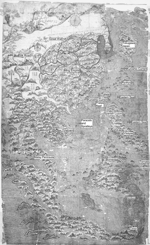
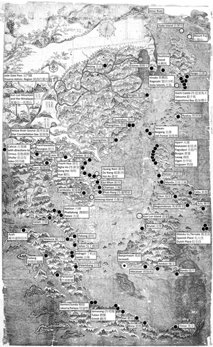
Fig. 2. on of selected inscriptions. The solid black dots indicate a labelled circle on the original; the open circles indicate islands that are labelled, but lack a circle. Oxford, Bodleian Library, MS Selden Supra 105. (© R. Batchelor. Map reproduced with permission from The Bodleian Library.)
The Selden Map
The primary importance of the Selden map stems from its depiction of Chinese merchant shipping routes across East Asia, which had gone unnoticed until that January (). These routes form a network from Nagasaki, Japan, south to Timor and Sumatra, a unique diagram of what contemporary texts called the eastern and western routes. The centrality to the map of the system of routes has been confirmed by the restoration work carried out by a team led by Robert Minte between the map's rediscovery in 2008 and its unveiling in September of 2011. Removal of the backing added in 1919 during conservation revealed a draft of the trunk route that runs from Nagasaki to Vietnam (). This particular route saw heavy traffic in the early seventeenth century from Japanese Red Seal ships as well as Chinese merchants, the Dutch East India Company (VOC) and the English East India Company.Footnote 4
Fig. 3. The Selden map of China with shipping routes highlighted. The north–south line marks approximately the central axis of the map, which should pass through Beijing in the north and just off the Vietnam coast at Champa in the south (see ). Oxford, Bodleian Library, MS Selden Supra 105. (© R. Batchelor. Map reproduced with permission from The Bodleian Library.)
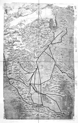
Fig. 4. Reverse of the Selden map of China, as revealed during restoration in 2010, with drafting marks highlighted. Oxford, Bodleian Library, MS Selden Supra 105. (© R. Batchelor. Map reproduced with permission from The Bodleian Library.)
It is conjectured that the map may have been made for a Chinese merchant family or organization with ties to Fujian. It could well prove to be the earliest survival of Chinese merchant cartography, unique among Chinese maps from the period in not being a product of Ming bureaucracy. On the front, more than sixty ports are labelled along the shipping routes in addition to countries, Japanese provinces, islands, reefs, rivers, mountains and currents (see ). Written directions from Calicut to ports near the Persian Gulf appear on the western edge of the map. A compass rose is placed centrally at the top of the map with a scale bar below it; both are discussed by Stephen Davies elsewhere in this volume.Footnote 5 Compass bearings in Chinese are given along the routes. The technical aspects implied by the mapping of sea routes, together with the map's probable merchant provenance, have persuaded scholars such as Timothy Brook and Zhang Zhiqing that it is the most important Chinese map to have been found in over a generation.Footnote 6
The Selden map has been in the collection of the Bodleian Library since 1659, when it arrived with the manuscript collection of the London jurist and legal theorist John Selden. The librarian Thomas Hyde and a visiting Chinese student, Michael Shen Fuzong, reviewed the map in 1687 at the Bodleian and appear to have annotated the map in Latin, as well as making the notes about the compass rose and other markings on the map that are now preserved in the British Library.Footnote 7 As David Helliwell has noted, for at least some part of the eighteenth century the map (or a copy of it) was on view at the Bodleian in the Anatomy School's cabinet of curiosities. One reason for its subsequent neglect appears to be that in November 1705 Edmond Halley, an expert on longitude and especially declination, dismissed the map as cartographically incorrect.Footnote 8 Although it underwent crude restoration work in the early twentieth century, the map was essentially forgotten. Halley appears to be the last person to examine the routes and technical aspects of the map before 2008.
In the early seventeenth century, while it was in the London collection of John Selden, the map would have had considerable geopolitical as well as commercial significance A 1653 codicil to Selden's will singled out this map from his large collection as particularly important:
a map of China made there fairly, and done in colours, together with a sea compass of their making and div isions, taken both by an English commander, who being pressed exceedingly to restore it at a great ransome, would not part with it.Footnote 9
Ironically, Selden in his treatise, Mare Clausum (1619) had opposed the kind of piratical seizure that had led to his possession of the map, arguing that demonstration of technical ability to measure the seas was the way to make claims of dominion over them.Footnote 10 He rejected Hugo Grotius's philosophy of ‘free seas’ and ‘just war’ that validated privateering as a legitimate strategy to counter Spanish and Portuguese claims in Asian waters, a doctrine that had allowed the capture of Chinese and other Asian merchant ships trading with the Iberians.Footnote 11
Chinese maps had been desired objects in London ever since Thomas Cavendish brought one back to London in 1588 as part of an effort to demonstrate the presence of independent sovereign empires there. In 1609, another Chinese map had been somewhat forcibly ‘taken’ from a merchant's house by an East India Company captain, John Saris, as payment of a debt. This was the printed woodcut sheet map of the Ming empire that Selden's friend, Samuel Purchas, re-engraved for his Pilgrimes in 1625.Footnote 12 Both the 1588 and the 1609 maps were examples of Ming imperial cartography in the tradition of Luo Hongxian and informed by data from the Ming census and taxation system. Legally obtained or not, the Selden map was the first Chinese map based on merchant data to have made its way to England, and at a global level it is the only one of its kind to survive.
Strikingly painted with depictions of trees, flowers, rivers and mountains in six colours (including white) and black Chinese carbon ink, the Selden map most likely was intended for display as well as reference within a wealthy merchant household. It is large, measuring approximately 158 × 96 centimetres, and would have required a substantial wall or table. It may have had an earlier fabric backing. Some damage has occurred along the top and right edges (possibly from a roller) and where it has been folded. On the reverse are thirteen evenly spaced triangular pieces of paper on the left and right sides.
The map was drawn on three pieces of mitsumata or sanyapi (三亞皮, from the Edgeworthia gardineri), a paper made from the Japanese plant of the same name that was cultivated in China and Korea by the seventeenth century and widely traded. It does not seem to have been produced as a working chart, but rather as a singular and aesthetically beautiful painting (hua, 畫) in the Chinese tradition of the scholarly landscape and panoramic route scroll. However, the route lines were drawn with technical instruments and the map's general cartographic style also marks its ties to the more prosaic form of a diagram or tu (圖), with which, in printed form, merchants especially would have been familiar.Footnote 13
Overall, the Selden map represents a seventeenth-century interface between Chinese painting and printing media as well as between a number of mapping traditions. Because of this, contemporary observers would have understood the map on several levels. They would have seen in the cartographical image of Ming provinces that incorporated astrological symbols paired with a representation of ocean-route networks based on compass directions a symbolical connection between official political structure and cosmological belief. At the same time, the map presented a comprehensive visual record that was usually available only in closely guarded manuscript pilots’ rutters or loosely described in diverse and often dated printed books. The aim in this article is to explore some of those interfaces, to introduce the newly discovered map to the history of cartography, and to touch on the basic aspects of its compilation and the possible reasons for, or context of, its creation. In the process much is revealed about the global significance of East Asian mapping during the seventeenth century, aspects of that history that have been forgotten, and the dynamics of Chinese merchant organizations during this period.
The Relation to Chinese Cartography
At first look, the Selden map appears to be an expansion of a traditional map of China. In such maps, the provinces of the empire are bounded in the north by the Great Wall and, usually, to the east by a narrow sea. A good example of such a map can be seen in , a printed map of the fifteen provinces of the Ming Empire from a popular 1607 encyclopaedia, which the maker of the Selden map used for the place-names within the empire and for some of the text cartouches to the north and west of the Great Wall ().Footnote 14 Information taken from the encyclopaedia map was reoriented so that Beijing fell along the middle axis of the Selden map, an adaptation that involved a substantial realignment of the content. Additionally, and strikingly, the Selden mapmaker created a richly detailed cartography of both mainland and insular Southeast Asia, which takes up more than half the map and makes the empire look small by comparison. Distorted versions of Japan and Korea as well as prominent depictions of Taiwan, Luzon and Visayas all suggest the increasing importance of the western Pacific or Dong Hai (東海). In contrast, the encyclopaedia map gives only a scant geography of overseas places such as Korea (朝鮮), Japan (日本) and Ryukyu (琉球), indicated by their names in cartouches. Clearly, the focus of the Selden map, with its central point falling in the middle of the South China Sea and key drafting points on the Vietnamese coast, is on the ocean. All this, in addition to the shipping routes, suggests a very different kind of map than is usually encountered in the imperial Chinese tradition.
Fig. 5. Printed map of the Ming Empire entitled Ershiba xiu fenye huang Ming gesheng di yu zong tu (二十八宿分野皇明各省地輿總圖, ‘Twenty-eight mansion, field-allocation, imperial Ming, all provinces terrestrial world map’) from the popular Ming encyclopaedia, Bianyong Xuehai qunyu (便用學海群玉, ‘Convenient to use: Seas of knowledge, mines of jade’), revised by Wu Weizi (Fujian, Xiong Chongyu from Jianyang, 1607), juan 2. Approx. 22 × 24 cm. North is at the top. To the northwest and west the Great Wall is marked with double broken lines and towers. In the ocean to the east are Korea (朝鮮), Japan (日本) and Ryukyu (琉球). The gourd shape in the lower left is the Star Constellation Sea (星宿海, Xingxiu Hai). This sole surviving copy is in Leiden University, Acad. 226. (Reproduced with permission from the University of Leiden.)
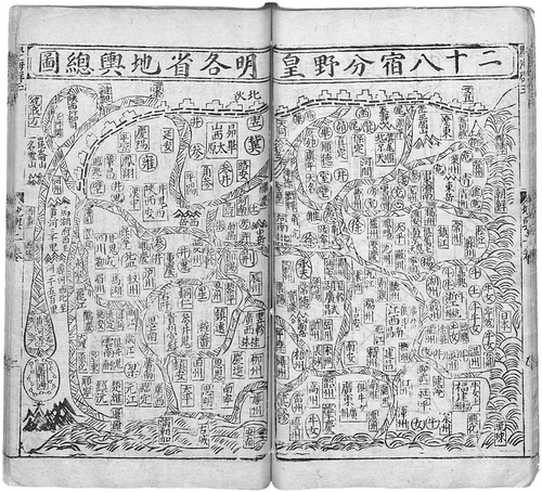
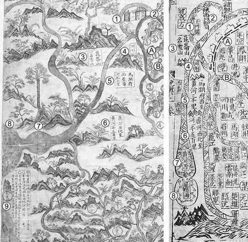
Fig. 6. Details from the western edge of the Selden map (left) and the same geographical area on the Ming encyclopaedia map (right). In addition to the addition on the Selden map of place-names for Burma and Siam, a box next to Calicut (古里国) gives instructions for reaching Aden (阿丹国), Zufar/Salalah (法兒国) and Ormuz (忽魯謨斯). The most important change is the transformation of the mythical Star Constellation Sea, the source of the Yellow River on both maps, into a bulbous Indian Sea on the Selden map. Inscriptions 1 to 8 are virtually identical on both maps, but Calicut (9) is not marked on the Ming map. A and B are examples of the copying of inscriptions in the western part of the province of Shaanxi (陜西). Oxford, Bodleian Library, MS Selden Supra 105; Leiden University, Acad. 226. (Reproduced with permission from The Bodleian Library and University of Leiden respectively.) (1) 玉門關, Yumen Guan, Jade Gate Pass; (2) 陝西行都司, Shaanxi xing dusi, Shaanxi Administrative Region; (3) 崑崙山, Kunlun Shan, Kunlun Mountain; and一名雪山, Yiming Xueshan, The Himalayas (?): Lit. ‘All snow-capped mountains’ (the Selden map adds the magical grain tree known as muhe (木禾), depicted here as a Chinese white pine, a source of pine nuts); (4) 河州, Hezhou; (5) 馬湖府西至黃河三千里, Mahu fu xi Huang He san qianli, Mahu west of Yellow River, three thousand li; (6) 麗河西北至黃河一千五百里, Li He xibei zhi Huang He, Li River northwest of Yellow River, one thousand five-hundred li; (7) 黃河水源, Huang He shuiyuan, source of the Yellow River (the Selden Map adds shui to emphasize that this is a terrestrial river rather than a cosmological connection); (8) 星宿海, Xingxiu Hai, Star Constellation Sea (note the shift from a constellation map to circles indicating islands); (9) 古里国, galiguo, Calicut. In Shaanxi (陝西) Province: (A) 臨洮, Lintao, and 鞏昌, Gongchang (in yellow circles on the Selden map); (B) Fenye markings for the constellations gui (鬼, ghost), bi (壁, wall) and jing (井, well) (in red circles on the Selden map).
The mapmaker seems to have been aware that the encyclopaedia map was a cliché, useful enough to people living in Fujian where it was printed, but not matching the experience of those living outside the Ming Empire. Maps like the one in the encyclopaedia promised a link to the cosmological power of the empire. The title of the encyclopaedia map, Ershiba xiu fenye huang Ming gesheng di yu zong tu (二十八宿分野皇明各省地輿總圖, ‘Twenty-eight mansion, field-allocation, imperial Ming, all provinces terrestrial world map’), highlights the cosmographical as well as geographical dimension of its design. In particular, the advertised fenye (分野, ‘field allocation’) symbols linked provinces in the empire, notably nine in the Han Dynasty, with the celestial fields (fen) of the Chinese zodiac, the twenty-eight mansions (xu, 宿) of heaven that were defined by constellations the moon passes through. Knowing the mansions for a province allowed divination to occur locally by observing the celestial events happening in them.
By the Ming period, the expansion to thirteen provinces and two administrative areas meant that on maps like the one in the encyclopaedia Jiangxi, Fujian and Guangdong all used the same fenye, while Yunnan and Nanjing had no fenye.Footnote 15 Sixty fenye markings are depicted on both maps, indicating the maker's desire to preserve the system despite its inadequacies; for example, the constellations gui (鬼, ghost), bi (壁, wall) and jing (井, well) for west ern Shaanxi (B in ) and nu (女, girl) and niu (牛, ox) for Fujian (). As Emma Teng has argued, in the case of Taiwan where fenye were tied to nearby Fujian, such stretching of the system prefigured the shift to a ‘symbolic geography’, which no longer indicated any direct link to sacred and imperial cosmologies.Footnote 16 Because of its association with a merchant diaspora, the Selden map's extension of networks far beyond the fenye of the empire itself illustrated the weakness of the cosmological system even more than Matteo Ricci's more comprehensive map of the world printed in Beijing in 1602.
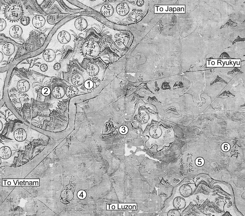
Fig. 7. Selden map of China. Detail showing Fujian, Taiwan and the navigational point off Fujian near (1) Quanzhou (泉州) and (2) Zhangzhou (漳州 ). Also visible are (3) the Penghu Islands (彭島), (4) Pratas Island and Reef (南澳氣 ), and (6) the Eastern Sea (東海). Between Taiwan and Luzon (5) the caption reading 此門流水東甚緊, ci men liushui dong shen jin, ‘This passage, flowing east, extremely tight’, indicates the beginning of the Kuroshio current. Oxford, Bodleian Library, MS Selden Supra 105. (Reproduced with permission from The Bodleian Library.)
The use of colour in the Selden map seems to be one aspect of this shift from maps as divinatory tools for cosmological orientation to the more purely symbolic relationships of places separated by measurable time and space. In the absence of colour, the encyclopaedia map typically denoted fenye characters by a circle and the place-name(s) within a rectangular cartouche. On the Selden map a more complex iconography is used, in which fenye characters are surrounded by a small but highly visible bright red circle. Other markings denote provinces separately in a sunburst pattern, also in red. For Beijing and Nanjing lines are added to this pattern to give the appearance of a crenelated wall. Port cities on navigational routes and administrative names within the Ming area appear in larger yellow circles. Cartouches are used for more extensive features such as mountain ranges or the general location of barbarian nations. For unclear reasons, the ports of Aceh, Hue and those near Kedah and Patani are circled in red. Occasionally more ornate structures are used, such as the gate for the Jade Gate Pass that marks the commencement of the Silk Road (see 1 in ). In general, while the compass directions of the routes still suggest a connection with the Ming provinces and their fenye markings, the technical aspects of the routes seem to take precedence over the symbolic clichés of Ming cosmology and the older Yuan connection to the Silk Road and the geographies of the west.
The mapmaker seems particularly sensitive to changing historical conditions, especially those requiring a reassessment of traditional Chinese geographical knowledge. The map depicts change across a large extent of eastern Asia from approximately the Amur River basin in the north, which replaces the Gobi Desert on earlier Chinese maps, to the Maluku Islands (Moluccas) in the south, where both the Spanish and Dutch are indicated. The eastern border of the map follows the Kuroshio current of the western Pacific, and includes textual references to both the current and the trans-Pacific route of the Spanish.Footnote 17
In the west, in the middle of the left side of the map and beyond the Malay Peninsula, India is identified by the port of Calicut, a location not shown on the Ming encyclopaedia map (see 9 in ). Beyond the subcontinent, in the western Indian Ocean, a gourd-shaped sea echoes the tradition that the source of China's Yellow River (黃河水源, Huang He shuiyuan) lay in what was commonly known as the Star Constellation Sea (星宿海, Xingxiu Hai), which is marked here by a scatter of little open circles with a central dot (see 8 in ) Here the break with traditional cosmology is particularly sharp—severing the linkage between the stars of the Milky Way and the Yellow River as the cradle of Chinese civilization and replacing it with physical geography.
The Compass Rose, Scale Bar and Trunk Route
At the top of the map are a compass rose, a scale bar, and an empty rectangular bordered box. On the reverse are drafts for two scale bars as well as the four marks indicating the box (see Figs 2 and 4). Stephen Davies, who makes the important observation that there were two different north–south orientations to the map to allow for magnetic declination, discusses these features in greater depth in the accompanying article in this issue.Footnote 18 Here we note a different, emblematic, dimension to the compass rose as well as its possible relationship to certain kinds of drafting tools.
The compass rose is composed of an outer and an inner circle. Twenty-four rays, each marked with one of the twenty-four cardinal directions along with eight major compass directions, surround a small circle reading luojing (羅經, compass). Below the compass is a scale bar divided into ten sections, each marked with an ‘x’, and each subdivided into ten sections with a longer line for the half mark. The scale bar is perpendicular to the due south (牛, wu / 正南, zhengnan) line of the compass itself. Both appear to indicate a declination of approximately six degrees.Footnote 19 This southward orientation corresponds to the famous ‘south pointing needle’ (指南針 zhi nan zhen) mentioned in texts from the Song Dyansty (960–1279) into the late Ming.Footnote 20 The two directional rays ding (丁) and bing (丙), one each on either side of due south, are extended in black-ink lines down to the scale bar.
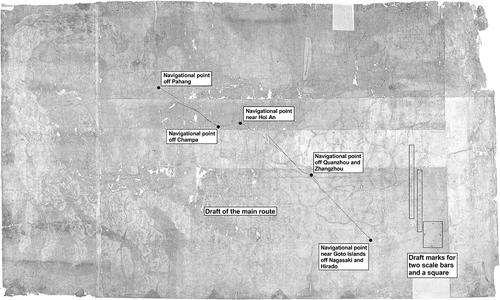
The small empty box seems to be, as Davies has suggested, a miniature version of the map itself, defining the declination of both compass and scale bar in relation to the basic frame of the map.Footnote 21 When Michael Shen Fuzong saw the Selden map in 1687, he distinguished between a gepan (格盤)—a strange phrase meaning ‘pattern board’ but likely a reference to the box—and the luojing of the label on the map.Footnote 22 It is unclear why, on the reverse of the map where there is a similar box, the scale bars and the trunk route were first drafted without this declination (see ). On the front, it would appear that the drafting marks for the box were drawn first, then the scale bar at an angle to it and, finally, the compass rose, from a line perpendicular to the scale bar.
The presence of a compass rose on a Chinese map is not typical, and the need to measure declination as well as plot and identify the routes seems to be the principal reason for its inclusion. The actual compass used for geomantic (堪輿, kanyu) orientation that Selden obtained together with the map also suggests that the compass had broader cosmological significance. Shen's 1687 description was elaborated upon by Thomas Hyde, who wrote, presumably informed by Shen:
The words in this circle are not really the names of any winds though in this case used for them but are the names of their Times without any gramaticall signification such as are used in their solar dials otherwise noting the China Hours which are of ours Two-hours; all taken out of their Cycle whence also are taken the names of their Lunar Months for every year different names, until the sayd cycle is finished in 5 years and again repeated for ever.Footnote 23
Hyde was describing the ru xiu du system (入宿度), in which the compass marks correspond to the twenty-four hours of the day for charting the sun as it moves through the constellations of the twenty-eight lunar mansions. In this light, we see that, while the compass rose was clearly intended for identifying and orienting the directional markings on the routes on the Selden map, it also served as a cosmological substitute for the inadequacies of the fenye markings for the Ming provinces on the encyclopaedia map to connect the vast space of the Empire.
As if to emphasize this, the representation towards the top of the map of the sun on the right and the moon on the left recalls the iconography of the Chinese myth of the intertwined creator deities Nüwa and Fuxi.Footnote 24 In many tomb and other paintings from the Tang dynasty the pair are depicted holding a drafting compass (gui, 規) and a measurement square (ju, 矩) with the sun above and the moon below them. The centre of the sun and moon in those images often has radiating spokes similar to those of the compass rose. Moreover, in the tomb paintings, chains of circles and lines representing constellations connect the sun and moon, as is often the case in later printed divination diagrams.
By contrast, on the Selden map the sun and the moon merely frame the compass, scale bar and pattern box. As with the similar removal of constellation lines from the Star Constellation Sea, the cosmological elements seem of secondary interest on the Selden map. They have given way to a rather more technical and mathematical role for the compass rose. This symbolic adornment of the sun and moon as well as the compass rose seems to have been designed to make the diagrammatic tradition of the tu (which also goes back to Fuxi's magic squares) more material by associating it with directional data and travel times for particular sea routes.
The introduction of the compass rose on the map is thus not merely a tool for declination, but also an indicator of a method of navigation more reliant on charts, magnetic compasses and directional data and less on star and sun positions and thus, by implication, cosmology.Footnote 25 The visualization of these techniques also seems to be an indication of the increasing importance and visibility of mathematical literacy during the sixteenth and seventeenth centuries in East Asia, which took shape variously in terms of accounting, geometric drawing and practices of linear algebra.Footnote 26
The Route Lines
All the routes on the map are clearly marked with straight lines similar to those used for the draft of the trunk route on the reverse. They appear to have been drawn by starting at a given marked point (yong, 用), opening a drafting compass to the length determined by the scale bar, creating a small arc with the compass and, finally, using perhaps a geomantic compass, the drawing of a line at a given directional angle to the arc. Each line is then labelled with the directional heading from the luo jing. Good examples are the two lines for the principal route, extending from two directions along the coast of Fujian near the heavily inked yong for Quanzhou (see ).
Three short lines lead away from this point off the coast of Quanzhou, two of which are marked jiamao (甲卯, 82.5˚) and dingwei (丁未, 202.5˚). One of these lines continues to the northeast (genyin, 艮寅 or 52.5˚) toward the Goto Islands (五島, Wu dao or five islands) off Nagasaki (Longzishaji for the Portuguese ‘Languesaque’ 笼仔沙机) and nearby Hirado (Yulin dao or ‘fish-scale island’, 魚鱗島) (). A second line goes southwest (kunshen, 坤申 or 232.5˚) toward the Da Nang Peninsula (在峴港) and Hoi An (會安), off the coast of modern Vietnam (Nguyen Cochinchina) between Thi Nai or Qui Nhon (新州) and Quang Nam (廣南), the launching point for Southeast Asian trade. The third line is marked bing (丙, 165˚) and heads towards Luzon and Manila. At navigational turning points, such as on the route to Ryukyu or the southern route from Guangdong to Luzon, small arcs can be seen made by the drafting compass that also serve as yong for other routes. No earlier surviving example of this technique is known.
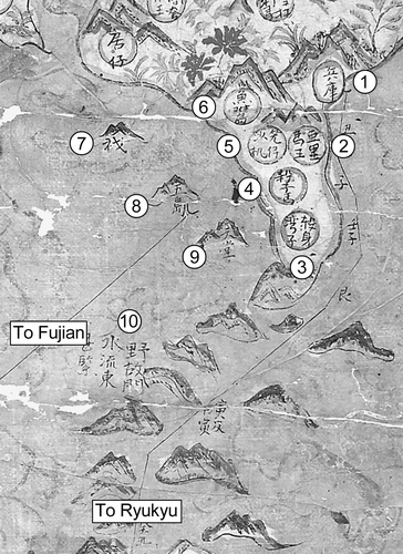
Fig. 8. Southern Japan on the Selden map of China. The red chrysanthemums near ‘fish-scale island’ (Hyogo/Firando) are unique on the map. The western (left) mercantile trunk route goes to Fujian and Vietnam. The eastern route is the traditional tributary route, dating back to the fifteenth century, from Fujian to Ryukyu to Hyogo. Oxford, Bodleian Library, MS Selden Supra 105. (Map reproduced with permission from The Bodleian Library.) (1) 兵庫, Hyogo (in Japanese): the port receiving early Ming embassies; (2) 亞里馬王, Yalima wang, possibly Shikoku Island or Kochi Castle; (3) 殺身灣子, Shashen wanzi, Kagoshima Bay; (4) 殺子馬, Shazima, Satsuma; (5) 笼仔沙机, Languesaque, transliteration of the Portuguese ‘Languesaque’ or Nagasaki; (6) 魚鱗島, Yulin dao, lit. ‘fish-scale island’ for Hirado (Firando); (7) 衣戈, Yige, Iki Island; (8) 五島, Wu dao, the five islands or Goto Islands: same characters and meaning in Japanese; (9) 天堂, Tiantang, lit. ‘paradise’, translation of Amakusa Islands (天草, Heaven's Grass); (10) 野故門水流東甚緊, Yegu men shuiliu dong shen jin, 'Yegu passage, eastward current, very tight’ (eastward current, indicating the Kuroshio current).
The written directions on the western edge of the map for separate voyages from Calicut in India (古里国) to Aden (阿丹国), to Zufar/Salalah (法兒国) and to Ormuz (忽魯謨斯) offer a clue as to how the map might have been understood as a tool related to navigation. They indicate that, as with most rutters, the scale of distance is based on the system of meas uring time through geng (更) or ship's watches.Footnote 27 But the directions also employ the word ji (計), meaning physically to plot or draft, rather than simply using what are often in the literature called zhenlu (針路) or ‘needle paths’. For example, similar data to that on the Selden map is found in the rutter Shunfeng Xiangsong that was owned by Archbishop William Laud in the 1630s, but there the word zhen or ‘needle’ was used as a verb when giving instructions for navigating rather than the Selden map's ji or ‘plot’.Footnote 28
Needle paths involved only a sequence of bearings (memorized or recorded in a manuscript rutter) from a given point, unlike a chart on which those points are related to each other. The contrast is perhaps clearest with the famous Mao Kun charts associated with the Zheng He voyages, first published in the 1620s in the Wu beizhi, on which the routes described in terms of zhenlu curve from port to port and are merely illustrative of the textual directions that literally follow the routes.Footnote 29 The probability that the Wu beizhi maps derive from a scroll rather than a chart also means that the routes tend to go in one direction in tributary fashion, rather than illustrating the more multi-directional and branching paths of a trading system.
Quanzhou
Aside from the yong off the coast of southern Fujian, marked in a line darker than normal, the clearest evidence on the map for the importance of Quanzhou as a trading centre is the number of routes in the vicinity (see ). The annotations show that all led away from the port—northeast to Japan, southeast to Manila and southwest to Vietnam. Quanzhou had a long history as a centre for trade with Southeast Asia and the Indian Ocean for many families of the Fujianese or Min diaspora, so it is not surprising that an understanding of routes would be tied to that port.Footnote 30
The contested nature of this navigational point off Quanzhou and Zhangzhou can be found in the contemporary work by a customs official from Zhangzhou named Zhang Xie. In his Dongxi yangkao (東西洋考, ‘Study of the Eastern–Western Oceans’; 1617–1618), Zhang explains that from 1594 Quanzhou and Zhangzhou engaged in an active controversy over Xiamen (Amoy) Island as a centre of maritime trade and debated the possibility of splitting the Eastern and Western routes between the merchants of the two cities. The result, according to Zhang, was that the customs office was moved in 1617 in an effort to reduce the power of Quanzhou. Quanzhou authorities, however, subsequently took over the Amoy garrison in 1621 and held onto it until the attacks by Zheng Zhilong in 1626–1627.Footnote 31
The Selden map seems to depict this period of struggle between Quanzhou and Zhangzhou, placing the latter just slightly further inland (see 2 in ). The differences between Zhang's account and the Selden map are substantial, but they overlap enough to suggest nearly contemporary production. Like the Selden map, Zhang mentions the Spanish in a famous account of Luzon (吕宋, Lusong) in juan (chapter) five of his book. Although book and map each list nine ports for Luzon, they agree on the names of three only. Zhang lists just four of the seven ports on the Selden map's depiction of coastal Vietnam. Zhang uses the term folangji (佛郎機) for the Portuguese and Spanish rather than the Selden map's huaren (化人), although, interestingly, both Zhang and the map use hongmao (紅毛) for the Dutch.
Irrespective of the subtle differences in language, Zhang's book and the Selden map share a certain understanding of trade dynamics. Rather than linking routes tightly to specific ports, as a traditional tributary account would have done or as the manuscript rutter Shunfeng xiangsong does, Zhang's classified list of ports in the table of contents at the beginning of his book is effectively a taxonomical hierarchy. The regional clustering of ports on the Selden map functions in similar manner, especially around Quanzhou where levels of trade with regions such as Luzon, Vietnam and Japan were high. Here large clusters of ports and cities have no direct connection to a route, making a distinction between local and regional commercial networks along the coast and the longer-distance ocean trade routes. The longer-distance routes carried the bulk of the important global flows of silver coming from mines in Japan, Spain's American colonies and the Dutch and English trading companies to feed the Ming empire's need for a currency standard.Footnote 32
What the Selden map makes clear, as do neither Zhang's book nor the Shunfeng xiangsong and the Wu beizhi, is the increasing importance of the global silver cycle in the shaping of East Asian trade and trading routes, and indeed traditional trading cities like Quanzhou. While routes on the Selden map still appear to point to the South China Sea as the central area of trade, as had been extensively described in rutters and travel writings from, especially, the Song (960–1279) and Yuan (1271–1368) dynasties, other aspects of the map point to the increasing significance of the Japanese and Spanish silver trade.Footnote 33 This influx of silver alters the cartographical situation completely and raises different issues of context. Although the Eastern Sea (東海, Donghai) is labelled in two places, the Southern Sea or Nanhai is not identified at all. Taken together with the marking of the north-flowing Kuroshio current from Luzon in the Philippines up along the Ryukyus and a legend on the eastern side of Luzon that refers to the presence there of the Spanish, this nomenclature suggests that the mapmaker had a strong interest in trading relations to the east and that the silver trade that passed through Manila was important to him or his patrons.
Two separate routes to Manila from the mainland come from Guangzhou and Quanzhou. Off Luzon, the reefs and rocky shoals in the shipping lanes leading into Manila Bay are particularly detailed. The toujin jiao (頭巾礁, turban reef or Capon Island) along the northern approach to the bay is named and so is jiawan men (甲万門, thousand-shell gate or, probably, the Maricaban Strait) to the south. Additionally, the two relatively new landings on Taiwan, which had become an important resupply point for merchant ships moving towards Japan from Manila and Vietnam in the first decades of the seventeenth century, are given visual prominence.Footnote 34 All this contributes to a recentring of trade near Fujian, connected to the silver trade with Japan and Manila. It also suggests a decentring of trade away from the Ming Empire that the military considerations of the Wu beizhi and the administrative ones of Zhang Xie do not effectively comprehend.
Landscape
Given the technical nature of the compass and the routes as well as the economic and geopolitical questions involved, the efforts made for the aesthetic dimension of the Selden map seem all the more surprising. The style of the depiction of mountains, rivers and seas associates the map with the Chinese landscape painting tradition known as 山水, shanshui (literally ‘mountain water’), in which the painting lets the observer enter, as it were, the landscape itself.Footnote 35 Likewise, the juxtaposition of mountains and seas as well as the quasi-mythic elements on the western edge of the map brings to mind the classical geography called the Shanhai jing (山海經, ‘Classic of Mountains and Seas’), which by the late Ming period was seen as a quasi-fictional text because of its tales of monsters and fabulous places. One could even link such gestures towards the landscape to the revival of the popular novel and the fashion for gardens as well as the depiction of flora on the porcelain and lacquer ware of everyday life in a merchant household.Footnote 36 In bringing elements from many of these genres and media together, the map is indeed one of the more interesting visual artefacts of the Chinese merchant diaspora we have from the late Ming dynasty.
Given this, surprisingly little attention seems to have been paid by the mapmaker to the oceans. The sea is colour-washed in a yellowish green with faint and conventional wave patterns. Around the Korean peninsula in the north, to the south and west of Borneo, and in the areas to the south of the Malukus, a darker shade of green was used. In the case of the Borneo area, the new sea colour blots out what was formerly an area of land. In the southeastern corner, the green may also be a correction that removes a former connection between Java and the chain of islands extending eastward to Timor and the broader area of the Malukus. Apart from these alterations, the map does not appear to have been much corrected.
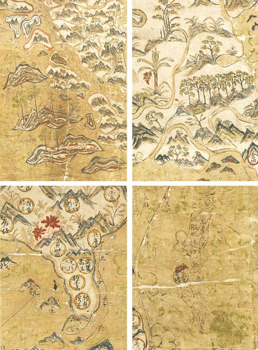
Our interest may be attracted to the unusual shipping routes, but the most eye-catching part of the map is the land, most of which is shown as highly mountainous. Unlike on some European maps (and indeed the textual descriptions of the Shanhai jing), no animals or monsters appear, but between the peaks and ridges lies a rich array of plant life. Many motifs are repeated. Some of the smallest plants are difficult to identify, but predominant are orchids, peony, pines, bamboo, cedar, palms, loquat and plane trees. Among these perhaps the most visually striking, and one of the clearest identifiable features on the map from a distance despite their small size, are two splashes of red colour in southern Japan (see and Plate 6, bottom left).Footnote 37 These appear to be chrysanthemums, a flower that in Japan referred not to the imperial throne (for which the appropriate colour is yellow) but often to true love.
The red chrysanthemums are located just above Hirado, the home of one of the wealthiest and most powerful Chinese merchants of the 1610’s Li Dan (李旦, aka Li Xu, 李旭, Andrea Dittis, Rey de China and Captain China, d. 1625). If the map were indeed made for Li Dan, as will be suggested below, the two flowers could be an allusion to his marriage in 1614 to a Japanese lady. Alternatively it could celebrate the betrothal in Nagasaki in April 1618 of one of his three daughters to another wealthy Chinese merchant, Goquan.Footnote 38 In either case, the extraordinary prominence of the two red chrysanthemums in southern Japan raises the possibility that not only was the map made for display, but that it might have been specifically commissioned as a gift symbolizing the uniting of important merchant families.
The trees are largest in the upper-left corner of the map, possibly because more space was available here in the remote interior of the continent. In style they correspond to traditional depictions offered in many painting manuals and depicted on commodities such as porcelains. Again, it is possible to identify species. Starting in the extreme top left corner of the map, and going from left to right, top to bottom, we find cedar (楠), plum (李), willow (柳), bamboo (竹), camphor (樟, with butterflies), pine (松) and palm (棕). Vera Dorofeeva-Lichtmann has noticed that the pine tree is placed on Kunlun Mountain (崑崙山), the traditional dwelling place of the gods of creation, Nüwa and Fuxi, and the location of the muhe (木禾), a giant tree producing unlimited grain (see 3 in , left).Footnote 39
The distribution of each tree species corresponds roughly to the appropriate latitude of its natural growth, but all would have been found as imported specimens in the gardens and compounds of Chinese settlements in mid-latitude cities such as Manila. These are also the types of trees found in contemporary horticulture such as penjing (盆景, basin scenery) and penzai (盆栽, basin cultivation), the Chinese forerunners of bonsai and the more elaborate Vietnamese hòn non bô. All have traditional associations as well. The clustering of bamboo, pine and plum, for example, represented the evergreen ‘three friends of winter’ (suihan sanyou), symbols of the scholar-gentleman's and samurai's attributes of flexibility, perseverance and purity.
Symbolism apart, each tree species, depicted with such attention to detail, can be seen as emblematic of what can be called the ‘littoral societies’ of maritime Southeast Asia.Footnote 40 The Ming Empire is portrayed in traditional terms, that is, connected by the rivers that functioned as vital commercial arteries, enabling the transport of goods and providing focuses of trade, and that delineated provincial boundaries. In Southeast Asia, riverine ports are shown nestling in the valleys amidst the hills and mountains from which highland goods and forest products were brought down for trade. A number of such commodities appear on the map. In India as well as Southeast Asia, red sandalwood (紫檀), represented on the map as small red-trunked trees, was a particularly valued commodity, specifically referred to in the inscription at Aceh, Sumatra, which reads ‘Sappanwood place near Aceh’ (蘇木達即亞齐, Sumu da ji Yaqi).
On the islands to the west of Sumatra, depicted in the lower left corner of the map, various species of palm extend the range of wealth in economic resources portrayed in the Selden map (see Plate 6, top left). And on the Malay Peninsula a row of what appear to be eight aquilaria trees (the source of cambalac or agarwood) next to a red banana tree also suggests the importance of tree plantations in providing forest products and food (see Plate 6, top right). The landscape thus appears to mix attention to specific commodities of trade and general features of the natural world of the East Asian littoral with the more conventional aesthetically oriented networks of domestic merchants in the Ming Empire or in Japan.Footnote 41 Once again we see, on the Selden map, an interface or marriage between two different social worlds.
Connections with European Mapping of East Asia
Although no Chinese or Southeast Asia maritime charts survive from before the arrival of the Portuguese, it is well attested that the Portuguese had obtained from East Asian merchants charts that bore some resemblance to the Selden map. For instance, the large chart with labels in Javanese captured by the Portuguese Viceroy of India, Afonso de Albuquerque, was reported to show the world from Portugal and Brazil to Taiwan and the Ryukyus and ‘the navigation of the Chinese and Gores, how their lines and routes are followed by the ships, and the hinterland, and how the kingdoms border on each other’ [italics added].Footnote 42 The map was lost in a shipwreck in 1512, but happily Albuquerque had already had Francisco Rodrigues translate the eastern part from Javanese into Portuguese so that King Manuel could ‘really see where the Chinese and Gores come from, and the course your ships must take to the Clove Islands, where the gold mines are, and the islands of Java and Banda, of nutmeg and mace, the land of the King of Siam, and also the end of the navigation in the land of the Chinese, the direction it takes and how they do not navigate farther’ [italics added].Footnote 43 We are left in no doubt that sea routes were clearly marked on early sixteenth-century East Asian charts showing the kingdoms and islands between Java and the Ryukyus just as they would be, so strikingly, on the map produced approximately a century later and now in Oxford.
If shipping routes had indeed been shown on merchant maps in East Asia since, possibly, the fifteenth century or earlier—from which they arrived in due course on Portuguese charts of the region—it is reasonable to suppose that other features on the Selden map that are also found on the Portuguese charts may have likewise originated in this older mapping tradition of the South China Sea. It is noteworthy that the outlines of the reefs and island of Pratas (南澳氣, Nan'ao qi), the Paracel Islands (萬里長沙似船帆樣, Wanli changsha si chuanfan yang, ‘The Paracels resembling the shape of a sail’), and the Spratleys (萬里石塘, Wanli shitang) in the South China Sea on the Selden map are conceptually more coherent and navigationally useful than the shapes found on sixteenth-century Portuguese charts and subsequent European maps of the region ().
Fig. 9. Left: detail from the Selden map of China showing the Paracel and Spratley islands, accompanied respectively by the mimetic form of a ‘sail’ and a ‘snake with veins’. Oxford, Bodleian Library, MS Selden Supra 105. (Map reproduced with permission from The Bodleian Library.) Right: The Paracels and Spratley islands from and (top and bottom respectively). In both these cases, the ‘sail’ and the ‘snake’ elements have been merged. (Maps reproduced with permission from the Hong Kong University of Science and Technology Library, Hong Kong, and the British Library, London, respectively.) (1) 萬里長沙似船帆樣, Wanli changsha si chuanfan yang, ‘The Paracel islands (10,000 isles) resembling the shape of a sail.’ The Wanli changsha are generally accepted to be the Paracels; (2) 嶼紅色, Yu Hongse, Red Islands, probably a transliteration of the Vietnamese term for the Paracels, Hoang Se (lit. ‘Yellow Sands’); (3) 萬里石塘, Wanli shitang, the Spratleys (?). This attribution from the texts of the period is today an issue of international sovereignty. The large cluster above the circle is filled with red dots, suggesting a connection with the adjacent inscription Hongse; (4) 在峴港, Da Nang Peninsula; and會安, Hoi An. The unidentified island is possibly Cù-lao Chàm. The inscriptions are difficult to read; (5) 里柬 (?), for the eastern-most island. Possibly Con Dao (west) and Cuo Lao Thu (east). The inscriptions are difficult to read; (6) 毛蟹洲, Maoxie zhou, Mekong Island; (7) 廣南 Guangnam, Quang Nam.
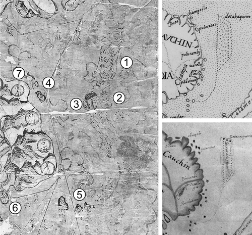
Fig. 10. Copperplate map of East Asia entitled Sinarum Regni aliorumque regnorum et insularum illi adiacentium descriptio., c.1597–1609. 47 × 35 cm. The undated and anonymous map was copied and printed from a now-lost Spanish draft that had recently arrived in Spain, probably from Manila, that had been completed in Madrid by 1609. The cartouche, which contains information taken from a Ming census gives the number of administrative divisions for each province and concludes: ‘in toto Sinarum Regno su 156 ceu, 235 Hhien, 1154 huy, zii su vero 213’. Note the ‘sail’ of the Paracels (see ). Hong Kong University of Science and Technology, G7400 1590.S54. (Map reproduced with permission from Hong Kong University of Science and Technology Library, Hong Kong.)
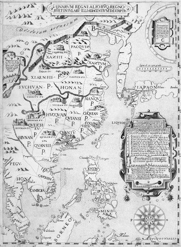
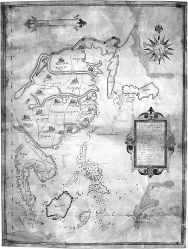
Fig. 11. Manuscript copy, made in Madrid in 1609 for the English envoy Charles Cornwallis, of the Spanish map of East Asia (see ). The shorter English version of the inscription notes that ‘The Kingdom of China’ has ‘150 great Cittes, 235 small ones, 1154 townes, villages decayed 211, forts of guard 213’. This map shows more to the south than the printed version and includes the whole of Borneo and the Malukus. Note the ‘sail’ of the Paracels (see ). British Library, Cotton Augustus, II.ii.45. (Map reproduced with permission from the British Library.)
The inscriptions on the Selden map help explain why the Paracels and Spratleys appear on Portuguese and other European charts and printed maps as a parallelogram with a tail. This form was derived from the merging of the Chinese folk tradition of the Spratleys’ resemblance to a sail with another Chinese tradition according to which the islands were said to look like the head of a ‘snake with veins’.Footnote 44 In comparison with European maps of Southeast Asia based on the Portuguese chart tradition, the maker of the Selden map appears to have had a much clearer idea of these islands and to have understood the problem of navigating in their vicin ity. Much, though, was lost in the transfer to European charts of information taken from captured maps or derived from local pilots.
The exchange of information was not all one way, however, and it would be wrong to conclude that the Selden map represents a static cartographic trad ition, unchanged since before the arrival of the Portuguese. The Europeans’ notion of East Asia was in many ways a product of debates over the Treaty of Zaragoza (1529), which tried to finalize the division of the world between the Portuguese and Spanish that had begun at Tordesillas in 1494. The Spanish settlement of the Philippines after 1571, along with the arrival of the Dutch and English in the 1580s and 1590s and the emergence of Tokugawa Japan as maritime challengers to the joint Iberian crown, reopened these questions.
Simultaneous and competing efforts by the Japanese, Dutch and English to depict East Asia on maps suggest the importance of new economic and geopolitical forces in the region in the late sixteenth and early seventeenth centuries. The number of Japanese charts that survive from this period points to the development of a more substantial trading identity than Chinese slurs about wokou pirates would indicate. Nakamura Hiroshi has remarked that Japanese portolan charts increasingly omitted the Indian Ocean after 1616 as a reflection of the actual routes plied by the Japanese.Footnote 45 The Japanese chart Ko Karuta (c.1613) owned by Kadoya Shichirojiro, a Shirako merchant venturer and ship owner who received an early Red Seal permit for helping Tokugawa Ieyasu escape death in 1582, and who relied on Portuguese charts, highlighted the same trunk route, from Nagasaki to Quang Nam, as found on the Selden map. The VOC's cartographer Hessel Gerritszoon also created a comprehensive chart to show the South China Sea (the Indische Noord of 1621). The English chartmaker Gabriel Tatton appears to have been working on a similar chart before his untimely death in Japan in 1621.Footnote 46 These Japanese, Dutch and English charts all implicitly rejected Iberian claims, both separate and joint (the 60-year personal union had begun with Philip II in 1580), to sovereignty over East Asian waters.
The most immediate reasons for Chinese merchants to reframe their own understanding of East Asian trading routes in the early seventeenth century were not concerned directly with sovereignty but with the interruptions to trade caused by struggles over it. The Spanish (huaren 化人) and the Dutch (hongmao 紅毛) are depicted jointly occupying the Malukus and, specifically, Ternate (万高, wanlaogao).Footnote 47 Their united action proved deeply disruptive to trade by setting off a series of Dutch blockades and reprisals that had their greatest effect on privately owned Chinese junks. The Dutch had removed the Portuguese from Ambon (唵汶, Anwen) in 1605, with the help of forces from Ternate, and had begun building a massive fortress there. In response, Spain in 1606 staged a large-scale invasion of Ternate from Manila, with some thirty-six vessels and twelve hundred soldiers, out of fear that the Chinese, the Japanese, the Dutch and the English all had designs to oust the Iberians from the Malukus. A stalemate and division of the island between the Spanish and Dutch ensued after the exile of the sultan to Manila in 1606–1607. Ternate is the one place on the Selden map where conflict between the Spanish and the Dutch had come to have a direct impact on Chinese merchant shipping.
The problem at Ternate may be the reason that the Selden map, especially if it were made in Manila or by someone in contact with the Spanish and Portuguese, appears similar in its general framing of East Asia to what is known of a Spanish manuscript map dating from the 1590s or early 1600’s. Although the original manuscript map does not survive, two derivative versions are known, a printed one made sometime after the original composition extant in only one exemplar and a manuscript copy made in Madrid for the English envoy Charles Cornwallis in 1609 ( and ).Footnote 48 These maps depict an area stretching from the equator to 50˚N in latitude while also covering forty degrees of longi tude, in modern terms, from approximately 100˚E to 140˚E. Excluding the reference to the Indian Ocean, the Selden map covers a slightly larger area, from perhaps 50˚N to 10˚S in latitude and from about 95˚E to 140˚E in the north and 95˚E to 130˚E in the south in terms of longitude. This has the effect on the Selden map of placing Manila precisely in the centre of the right-hand side of the map (see ).
Plate 5. The recently rediscovered Selden map of China (c.1619). Ink and watercolour on paper. Approx. 158 × 96 cm. Its outstanding feature is the system of shipping routes and emphasis on ports in Southeast Asia, from Japan to Sumatra, that bound the region’s mountainous hinterlands and littorals together through trade. Oxford, Bodleian Library, MS Selden Supra 105. (Reproduced with permission from The Bodleian Library.) See pages 37, 97.
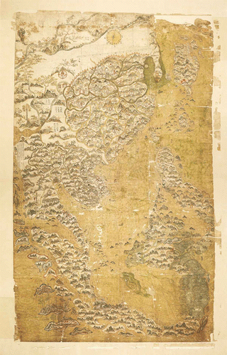
Plate 6. Details from the Selden map of China to show the map’s ‘painterly’ style and the realistic portrayal of vegetation. Top left: palms on the islands west of Sumatra. Top right: a row of eight aquilaria trees, suggestive of a plantation, with a red banana tree. Bottom left: Japan, with the two red chrysanthemums that stand out prominently on the map (see Batchelor, Figure 8). Bottom right: the Paracel and Spratley islands with, between them, the island, touched up in red, that served as the datum point in the map’s construction. Oxford, Bodleian Library, MS Selden Supra 105. (Reproduced with permission from The Bodleian Library). See pages 50, 51, 52 (Batchelor) and 100 (Davies).
On the two maps derived from the Spanish manuscript map, the location of Beijing (Shuntian or ‘Xuntien Fu’) along the central axis of the map defines the parameters of East Asia as much as the Straits of Malacca and Japan do for the western and eastern borders. Somewhat surprisingly, there was little precedent before these Spanish maps among either the Iberians or the Chinese for placing Beijing on the central meridian of a map of East Asia.Footnote 49 As Abraham Ortelius in Antwerp and other Spanish and Portuguese mapmakers did in the 1570s and 1580s, and indeed as the compiler of the Selden map did, the maker of the Spanish manuscript map had used a printed map of the Ming Empire not centred on Beijing as his model for the mainland. Moreover, on the Spanish maps, Beijing, Quanzhou (‘Chanchieu’) and Manila all appear along a single meridian slightly to the left of the map's centre, at approximately 18˚ on a scale of zero to forty on the printed version (see ), suggesting a Spanish desire to make connections between Beijing and ocean trade.
This re-alignment would have appeared strange to the large number of local merchants long familiar with the Quanzhou to Manila route, since the direction of the Spanish route did not run due south. On the Selden map, Manila, Quanzhou and Beijing likewise fall along a single diagonal. This line, however, follows the directional heading of bing (丙, 165˚), which is the marked direction for the route from Manila to Quanzhou, and parallels the right bing line that is drawn from the compass to the scale bar. This south-southeastern line also fits modern longitude values for Manila (121˚E), Quanzhou (118.6˚E) and Beijing (116.4˚E) in relation to true north. It could be that the Selden map's compiler was trying to find a value for declination, a heatedly disputed problem at the time. Or it could be that the Selden mapmaker was simply adjusting known navigational data to allow for the errors of these Spanish maps that were emerging into circulation as part of the propaganda battle over claims to sovereignty. What seems to be in evidence in these late sixteenth- and early seventeenth-century European and East Asian maps, then, may more appropriately be described as a contested understanding of East Asia than as just reciprocal transfers of knowledge, in which, as the Selden map reveals, Chinese merchants played an active and innovative role.
The Date and Composition of the Selden Map
Beyond the clear reference to the events of 1605–1606 on the Selden map there are, unfortunately, no markings to help identify its precise provenance. The dense clusters of ports in Vietnam, Japan and the Philippines, as well as the trunk route itself running between these regions, seem to offer some hints. So far, the emerging scholarly consensus has been that the Selden map was drawn sometime between 1618 and 1624.Footnote 50 It appears to fit into a historical window after the publication of Zhang Xie's 1617–1618 treatise on maritime trade and before the merchant-pirate Zheng Zhilong began to build up his own maritime empire through trading networks converging on the Penghu (Pescadores) Islands, Taiwan and Fujian from 1624 to 1626. The Dutch set up a base on Penghu (澎湖; labelled simply peng 彭 on the Selden map) in 1622, but the Selden map shows the Dutch only on Ternate. As research progresses, and the context is narrowed, the date range is closing.
Blockades
One reason for compiling a comprehensive image of Chinese trade routes could have been the Chinese merchants’ anxiety to find ways of circumventing the Dutch blockades that began after 1606. The Dutch legal theorist Hugo Grotius's ideology of ‘free seas’ and ‘just war’ was used to support the seizure of both Iberian ships and any merchants trading with them. After 1609, the Dutch had an operational base in Japan at Hirado, and the English followed in 1613 with the help of Li Dan. In 1614, the Dutch had obtained permission from the States General of the Netherlands for the VOC to engage in sustained action against the Spanish and Portuguese from Ambon and Ternate. All too often this resulted in the capture of Chinese merchant junks, as in the spring of 1616 when, according to rumours circulating in Hirado, between twenty-five and thirty-five Chinese junks filled with Spanish silver fell into Dutch hands.Footnote 51 By 1618, however, it was clear in both Manila and Hirado that, because of the monsoon patterns, the Dutch were having to retreat to the Malukus and Java each June to await the winds coming from the southeast in July, leaving the seas to the Chinese merchantmen.Footnote 52
The English, on the whole, did not participate in the Dutch blockades. They had made peace with Spain and Portugal and had no particular desire to disrupt Chinese shipping. They did, however, seize the ships of some Chinese merchants—from Banten (Bantam), Java, in 1619 and off Sumatra in 1622—in their attempts to reclaim debts.Footnote 53 Then from January 1621 to May 1622 they joined with the Dutch, as the ‘Anglo-Dutch Joint Fleet of Defence’, to engage in blockades of Manila. Even more significantly, in the summer of 1620 an English vessel named the Elizabeth, on its way to Hirado to join this fleet, seized a ship captained by a Japanese off Taiwan. The ship's cargo was at least partly owned by the Chinese merchant Li Dan. The action, which was to have major political reverberations in the area, not only may explain how the Selden map reached England, but also raises the possibility that it was made in, or at least passed through, Manila.
The Elizabeth
It is a pity that the East India Company's records appear relatively complete in all cases of piracy and blockading by the English except for the activities of the Elizabeth in August 1620.Footnote 54 In no instance is mention made of anything resembling the Selden map, yet the adventures of the Elizabeth may be crucial to the history of the map. The relevant events have to be pieced together as best possible.
What is clear is that in the summer of 1620 a Chinese junk, or perhaps a Japanese ‘frigate’, assumed the Dutch were safely out of the way for the monsoon season and set out from Manila for Nagasaki by way of Macao, putting in at Taiwan for fresh supplies.Footnote 55 Among those on board the junk were a Portuguese pilot Diego Fernandez and two Spanish priests, Pedro Manrique de Zuniga and Luis Flores, who were trying to smuggle themselves into Japan disguised as merchants. By chance, the Elizabeth had stopped at Taiwan as well, and seeing the Iberians there, felt justified in seizing the ‘frig ate’, which they later claimed was Portuguese. The captured ship was full of silk, ginger and cotton that had been bought on the mainland with Manila silver and was intended to be sold on the Japanese market. After a lengthy process, the main cargo was eventually confiscated by Japanese authorities on the grounds that it belonged to Japanese and Chinese merchants (including Li Dan) who had been abetting the Spanish. But the Elizabeth’s captain, the unpopular Edmund Lenmyes, was widely rumoured to have taken a chest of gold before the ships reached port, and if Selden's future map and compass were on board, they possibly fell into the hands of Gabriel Tatton, the Elizabeth’s chartmaker.
The Japanese authorities were anxious not to give the Ming rulers the impression they supported piracy. At the same time they feared Spanish and Portuguese Catholicism as a disruptive influence, preferring to side instead with English, Dutch and Chinese merchants as less of a threat to local political stability. But by December, the Japanese were threatening to impound the goods captured by the Elizabeth and to imprison its crew for piracy. During the ensuing obscure and largely secret negotiations over the crew and cargo, in which Li Dan became implicated as having a share in the cargo and as a potential smuggler of the priests, the map (assuming it had been captured) would have remained hidden as evidence of the English not fully cooperating and of Li Dan's collaboration with the Spanish.
All concerned—Li Dan, the English and the Dutch—tried to protect their respective organizations by focusing attention on the priests who had been captured and who would have most likely known nothing of the map as opposed to the nature of the cargo. The result was that the priests, together with the Japanese captain of the ship and more than 120 residents of Nagasaki, were executed in August and September 1622 in what came to be called the ‘Great Martyrdom’. A year later, in 1623, a sizable part of Li Dan's possessions in Hirado were impounded, and the English disbanded their factory at Hirado, to which Li owed a debt of 6000 tael, under a cloud of malfeasance by its chief factor Richard Cocks.
What archives survived the episode and returned to London—among the items were Gabriel Tatton's charts, Richard Cocks's diary, and Cocks's library of Japanese books—were dispersed because of the deaths of the main people involved.Footnote 56 If the Selden map had been brought to Japan on the Elizabeth, there is good reason to suppose it also reached England sometime in 1624, although the records are totally silent in the matter. It is not clear when Selden acquired the map. He may have got it, along with the Codex Mendoza, from Samuel Purchas in 1626 or around the time Laud acquired the Shunfeng xiangsong sometime before 1637. All that is certain is that many such objects circulated in early seventeenth-century London, and we know about most of them only because of Laud's and Selden's donations to the Bodleian.
Li Dan as Map Patron?
If it is assumed that the Selden map had indeed been captured by the Elizabeth, it has also to be assumed that it owed its creation in the first place to Li Dan, a person who has left only a murky record in the archives, although more traces than many other such merchants. By the early 1620s, Li Dan was sufficiently established as a merchant to send others, including his brother, on trading voyages. According to most sources, Li had been born in Quanzhou, Fujian, emigrated to the Chinese quarter in Manila known as the Parian, and became a successful businessman before, on falling into debt over an unpaid 40,000 tael in Manila, he was sentenced to the Spanish galleys that were patrolling the coasts of Luzon around 1608. He escaped to Hirado, Japan, where, with substantial capital investment from Chinese merchants, wealthy Japanese individuals, and Dutch and English trading companies, he built up a huge shipping empire. Li Dan's ships sailed from Japan as far as Siam, and they plied routes that took them to the ports of Champa, Tonkin, Manila, Taiwan, Guangzhou and Quanzhou. From July 1617, Li was also regularly sending ships to Taiwan, to where he moved to assist the Dutch in 1623–1624 after some of his wealth had been confiscated in Japan.
If any Chinese merchant were to be in a position to commission a piece as extensive as the Selden map, it would seem to have been Li Dan. We have already noted a possible motive, the marriage of his daughter to another powerful merchant. He owned a well-appointed compound in Hirado. Over the years 1615–1621, he raised 6,250 silver tael (c.234.4 kg) of English investment alone, claiming through agents at Banten on Java that he had extensive contacts in the Ming Empire itself. The final payment from the English (1,500 tael) reached him in January 1621, six month's after the English seem to have unknowingly captured his goods in the Elizabeth episode.Footnote 57 If the rumours of Chinese merchants are to be believed, he had a much larger 30,000 tael investment fund assembled from Osaka and Nagasaki merchants, the Bankufu or Shogun's government itself as well as Fujianese merchants.Footnote 58 The Japanese hardly dared touch him, and he enjoyed too many connections in Japanese society to be burned publically in the Great Martyrdom.
The Selden map almost certainly was not made in Japan. It shows only the southern part of the country and details are poor compared with those for Luzon and the coast of Vietnam. Many of the actual labels on Japan are simply zhou (州), meaning province, and the scale-like sections of the upper part of the single island look like a traditional eighth-century Gyoki map, but one hastily copied or perhaps memorized. Like Japan on the Selden map, Gyoki maps frequently framed Japan using Sado Island (佐渡州, Zudou Zhou), Kyushu and Shikoku (labelled 亞里馬王, Yalima Wang, on the Selden map). Some unique transliterations of famous Honshu tourist sites that would have been little known in China are given, such as Yishi (伊勢, Ise Shrine) and Qidao Shan (七島山, ‘Seven Island Mountain’), the latter an idiomatic reference to, with depiction of, Mount Fuji. The map does reflect a reasonable knowledge of the dense scatter of the islands off the southwest coast of Kyushu, which Chinese and European traders frequented, as well as Tsushima Island (水剩馬, Shuishengma), gateway for trade with Korea.
The Selden map could easily have been made in Manila or Fujian. In Manila, an artist could have had access to one of the Spanish maps of East Asia or seen the manuscript version. However, if it were made in Manila, Li Dan himself almost certainly never saw it, since he remained in Japan during this period. Li's son, Li Guozhu (known to Europeans as Augustin), though, did travel to Manila from Nagasaki in the summer of 1618, which also fits with the general timeline.Footnote 59 Regardless of the map's provenance, which further research may reveal, the traces that do survive about the Li family in the historical record, along with the pastiche of source materials used to create the map itself, offer a sense of how such a map would have been constructed and the reasons why it would have been made. The Japanese Red Seal ship trade, the arrival of Dutch and English traders in the 1610s, and the expansion of Fujianese merchant networks like those of Li Dan in Hirado, had all made the trunk route passing Quanzhou popular with Japanese, Chinese and European ships carrying silver and increasingly subject to new kinds of cartographical techniques.
An Object of Global Significance
However sparse definitive information about the history of the Selden map may be, the map offers a rich cartographical image of the economic dynamism of seventeenth-century East Asia. This in itself is remarkable, because commercial records tend to be fragmentary and incomplete. Unlike the institution-based activities of the Dutch and English in the area, most Chinese economic activity was the responsibility of individual merchant families, whose records were not preserved in company archives. Yet the map's maker was able to draw on an impressive variety of sources to configure trade relationships to focus on the sea rather than inland waterways. He also enriched his image with allusions to contemporary understandings of sovereignty, nature, space and time.
The map also gives new insights into English thinking about the oceans, commerce and empire in the early seventeenth century. That Selden came to value it for its public interest—specifically wanting it to go to the Bodleian, the only library in England at the time open to non-university members—is telling.Footnote 60 For Selden, his Chinese map could be used to demonstrate that measuring the sea was a way of establishing a kind of dominion or possession in East Asia and to give a global and universal character to his own arguments about closed and proprietary seas. In the Latin printed edition of his Mare Clausum (1635), Selden had first publically articulated the argument that sovereigns could exert dominion over the seas. With the first Navigation Act of 1651 regulating British shipping and the supporting English translation of Mare Clausum (1652), closed-seas arguments came to be seen as necessary for articulating policy for the Atlantic. Selden's concept of closed seas defined by contract law and the technical ability to measure space dominated English thinking until the overturn of the Navigation Acts during the American Revolution and the active pursuit of free-trade policies in East Asia in the Opium War.
The Selden map thus obliges us to pause to reconsider some fundamental assumptions, notably the privileging of the Atlantic world as the birthplace of modernity, science and capitalism, and the concomitant view of the West as Atlantic-centred. Likewise, the map prompts reflection on historical methodology in the way it draws attention to the importance of intertwined external political and commercial relationships when assessing seventeenth-century East Asia. Claims to the ocean were not merely asserted by sovereign states so much as negotiated by a series of sovereign and contractual stakeholders utilizing what were perceived as shared, rather than ‘free’, resources.
Exchange networks in the seventeenth-century as developed by entrepreneurs like Li Dan, or by organ izations like the English and Dutch East India Companies operating at considerable distances from their metropolitan bases, pushed contractual relations ahead of state formation.Footnote 61 The efforts of Zheng Chenggong and Zheng Jing, the successors to Li Dan's commercial empire who themselves ousted the Dutch from Taiwan in 1662, revealed the failure of Dutch free-seas policies, supposedly rooted in natural law, compared with English efforts to close the seas through legislation.Footnote 62 In the end, part of the development of the massive Qing Empire that succeeded the Ming in 1644 was a reaction to complex commercial developments that had already begun in the previous period as suggested by the Selden map itself.
It is appropriate that the Selden map has been rediscovered in an age that sees itself as digital and global. Dismissive notions of mere ‘piracy’ in commodity exchange and information transmission in seventeenth-century East Asia, echoed in debates of the twenty-first century, point to what is missed when historical trends are reduced to the internal activities of countries or empires. In its depiction of the environment and its emphasis on relationships that were, in the context of the day, global, the Selden map shows that these are not entirely new matters. The cartography of the Selden map in effect asks the viewer to examine the way trade is shaped by, and in turn reshapes, the natural world. In its perspective—not that of a snapshot but of process—as well as in its content, the Selden map is a remarkable and so far unique creation from early seventeenth-century East Asia.
Acknowledgements
My thanks are due to David Helliwell, the Bodleian Library and the Pilgrim Trust for seeing the importance of restoring the map. This article has benefited from much advice, especially from Stephen Davies, Vera Dorofeeva-Lichtmann, Go Bon Juan, Robert Minte, John Moffett, Hyunhee Park, Haun Saussy, Patricia Seed, Peter Shapinsky, Richard Smith, Sarah Tyacke, Charles Wheeler, Jack Wills, Frances Wood, and the editors of Imago Mundi. I am also indebted to the conveners and participants of several symposia: ‘The Rediscovery of the Selden Map,’ Georgia State University, Atlanta, March 2011 (Nick Wilding); ‘Discovering the Selden Map of China Colloquium’, Bodleian Library, Oxford, September 2011 (David Helliwell); ‘Pirates, Silk, and Samurai: Maritime China in Global History Conference’, Emory University, Atlanta, October 2011 (Tonio Andrade); and ‘Cartography and Creativity’, Duke University, Durham, March 2012 (Philip Stern and Sumathi Ramswamy). This article was commissioned at the Discovering the Selden Map of China Colloquium, Bodleian Library, Oxford, September 2011.
Notes
1. Nathan Sivin and Gari Ledyard, ‘Introduction to East Asian Cartography’, in The History of Cartography, vol. 2, book 2: Cartography in the Traditional East and Southeast Asian Societies, ed. J. B. Harley and David Woodward (Chicago, University of Chicago Press, 1994), 23.
2. Gavin Menzies, 1421: The Year China Discovered the World (London, Bantam, 2002). On Menzies, see Geoff Wade, ‘The Liu/Menzies world map: a critique’, e-Perimetron 2:4 (2007): 273–80. Menzies’ primary cartographic evidence comes from the Piri Reis chart and Fra Mauro maps as well as the Wu beizhi and the Korean Kangnido map tradition (c.1402).
3. Bodleian Library, MS Selden Supra 105. When David Helliwell, Curator of Chinese Collections at the Bodleian, and I opened the map, I noticed the unusual sea routes marked on it. Helliwell has been systematically recata loguing the seventeenth-century collection of Chinese materials in the Bodleian and in Europe more generally; see his ‘Chinese Books in Europe in the 17th Century’, http://www.bodley.ox.ac.uk/users/djh/17thcent/17theu.htm, and the 15 February 2012 entry for his blog Serica, http://oldchinesebooks.wordpress.com/2012/02/. Because the map itself has no title in Chinese, Helliwell has accepted 東西洋航海圖 (Dongxi yang hanghai tu) coined by Chen Jiarong as the Chinese name for the map.
4. For shipping data, see Iwao Seiichi, Shuin-sen Boeki-shi no Kenkyu (Tokyo, Ko Bun Do, 1958), 107 and passim; Li Tana, Nguyen Cochinchina (Ithaca, NY, Southeast Asia Program Publications, 1998), 62–65. The diplomatic documents can be found in Hayashi Akira et. al., Tsuko ichiran vol. 8 (Tokyo, Kokusho Kankokai, 1912–1913), 481–87.
5. See Stephen Davies, ‘The construction of the Selden map: some conjectures’, Imago Mundi, 65:1, 97–105.
6. At the time of going to press (summer 2012), I have been unable to consult Timothy Brook's book, Who Drew the Selden Map? (London, Profile Books), which has been advertised as due for publication in 2013.
7. British Library, MS Sloane 853, fol. 23.
8. See Thomas Hearne, ‘An Extract and particular Account of the rarities in the Anatomy School’, Bodleian MS Rawl. C 865, reprinted in R. T. Gunther, Early Science in Oxford, vol. 3 (Oxford, Hazell, Watson and Viney, 1925), 264–74; and Thomas Hearne, Hearne's Remarks and Collections, vol. 1, ed. C. E. Doble (Oxford, Clarendon Press, 1885), 70. The passage in Hearne implies that the Anatomy School actually received a copy of the map: ‘Today Mr. Halley coming to ye Library, Dr Hudson shew'd him Mr. Selden's large MSt Map of China (whereof there is a Copy amongst Dr. Bernard's MSS. That is to be put into the Anatomy Schoole) to wch Dr. Hyde added some Explicatory Notes. Mr. Hally having taken a view of it, concluded it to be full of faults, from some wch he knew to be so from his own observations’.
9. ‘Codicil’, 11 June 1653, in David Wilkins, Works of John Selden, vol. 1 (London, 1726), lv. The compass that accompanied the map is now Oxford Museum for the History of Science, 44055.
10. The original (lost) manuscript circulated in the summer of 1619 at the request of Buckingham, the new Lord High Admiral, but James I wanted it changed, and it was rejected on its second submission. See G. L. Toomer, John Selden: A Life in Scholarship, vol. 1 (Oxford, Oxford University Press, 2009), 388–432; David Berkowitz, John Selden's Formative Years (Washington, Folger Library, 1988), 54–55, 308–9. Selden tells his version of the story (mistakenly remembering it as 1618) in Vindiciae Joannis Seldeni (London, Cornelius Bee, 1653), 15–28. Selden finally published a revised version during the ship-money controversy under Charles I as Mare Clausum seu De dominio maris (London, William Stanesbeius, 1635). The English edition appeared in support of the first Navigation Act as Of the Dominion, Or, Ownership of the Sea, transl. Marchmont Nedham (London, William Du-Gard, 1652), at which time Selden's map could be seen in his house, Carmelite, in Whitefriars. The relevant passages on the measurement of the sea are in book 1, chapter 22, (1635), 91–97; (1652), 135–45.
11. Grotius's work had been translated into English by Richard Hakluyt from Mare Liberum (Leiden, 1609), a second edition appeared in 1618. See Hugo Grotius, The Free Sea, transl. Richard Hakluyt, ed. David Armitage (Indianapolis, Liberty Fund, 2004).
12. Samuel Purchas, ‘The Map of China, 皇明一统方舆備览, taken out of a China Map printed with China characters, etc. gotten at Bantam by Capt. John Saris’ [Huang Ming yitong fang yu bei lan, ‘Comprehensive directional view map of the Imperial Ming’], in Purchas his Pilgrimes, vol. 3 (London, William Stansby, 1625), 400–1.
13. The word tu was used as a general term for maps, but it could also refer to a wide range of diagrammatic material in printed primers and encyclopaedias, for stellar diagrams and even ancestral charts (宗支圖本, zhongzhi tuben). See Francesca Bray, ‘Introduction’, in Graphics and Text in the Production of Technical Knowledge in China, ed. Francesca Bray, Vera Dorofeeva-Lichtmann, Georges Métailié (Leiden, Brill, 2007), 1–5; Vera Dorofeeva-Lichtmann, ‘The political concept behind an interplay of spatial “positions”’, Extrême-Orient, Extrême-Occident 18 (1996): 9–33; and Michael Lackner, ‘Die Verplanung des Denkens am Beispiel der tu’, in Lebenswelt und Weltanschauung im frühneuzeitlichen China, ed. H. Schmidt-Glintzer (Stuttgart, Franz Steiner Verlag, 1990), 134–56.
14. Bianyong Xuehai qunyu [便用學海群玉, ‘Convenient to use: seas of knowledge, mines of jade’,], revised by Wu Weizi (Fujian: Xiong Chongyu from Jianyang, 1607), juan (chapter) 2. See Koos Kuiper, Catalogue of Chinese and Sino-Western Manuscripts in the Central Library of Leiden University (Leiden, Leiden University Library, 2005), 70–75. For similar encyclopaedias, see Wu Huifang, Ming-Qing shiqi de minjian shenghuo shilu (Taipei, National Cheng-chi University, 2001), 641–59. The surviving copy of the encyclopaedia, now at Leiden University Acad. 226, was most likely obtained in Batavia by the Dutch missionary collector Justus Heurnius in the late 1620’s. It, like many of the books in the Bodleian's collection from the same period, is a good example of the kinds of materials brought to overseas Chinese settlements in Southeast Asian ports. On such printing, see Lucille Chia, Printing for Profit: The Commercial Publishers of Jianyang (Cambridge, Harvard University Press, 2002); and on the Chinese books circulating in Manila, see idem, ‘Chinese books and printing in the early Spanish Philippines’, in Chinese Circulations, ed. Eric Tagliacozzo and Wen-Chin Chang (Durham, NC, Duke University Press, 2011), 259–82. Examples of printed maps that circulated outside of China include sheet maps like Yu Shi, ‘Gujin xinsheng zhi tu’ [Map of China past and present] (Longxi County, Fujian, Jinsha Studio, 1555), and the Purchas, ‘The Map of China’ (see note 12), as well as the 1579 version of Luo Hongxian's atlas Guang yutu quan shu.
15. John Moffett has called attention to the fenye markings on the map. On fenye versus geomancy or the ‘Form’ vs. ‘Compass’ schools, see especially Richard Smith, Fortune-tellers and Philosophers: Divination in Traditional Chinese Society (Boulder, Colorado, Westview Press, 1991), 67–70, 134–39; and John B. Henderson, ‘Chinese cosmographical thought: the high intellectual tradition’, in Harley and Woodward, History of Cartography (note 1), 2:2: 210, 216–24
16. Emma Teng, Taiwan's Imagined Geography (Cambridge: Harvard University Asia Center, 2006), 58.
17. Specifically a notation in the northern islands of the Ryukyus, 野故門水流東甚緊 (Yegu men shuiliu dong shen jin, 'Yegu passage, eastward current, very tight’) and one between Luzon and Taiwan, 此門流水東甚緊 (ci men liushui dong shen jin, ‘This passage, flowing east, extremely tight’): see and A remarkably similar formulation with different directional headings occurs in Bernhard Varenius, Geographia Generalis (Amsterdam, Elzevier, 1650), 201, who writes, ‘Similis motus versus Boream observatur in ostio freti Manilentis ad Philippinas. Ita in Japone motus incitatissimus a portu Xibuxia versus Arimam’ [A similar motion towards the north is observed in the Strait of Manila near the Philippines. Likewise in Japan a strong motion from the port of Xibuxia towards Arima’. Francois Caron, head of the VOC's Hirado factory in the 1620’s seems a likely source for Varenius's information. In an empty space east of Luzon is the inscription 化人番在此港往來呂宋 (Huarenfan zaichi gang wanglai Lusong, ‘Spanish foreigners go back and forth from this harbour to Luzon [Manila]’), indicating the trans-Pacific silver route.
18. Davies, ‘The Construction of the Selden map’ (see note 5)
19. Declination is notoriously difficult to determine in this period. The English theorist of magnetism William Gilbert in De Magnete (London, 1600) complained about the inaccuracy of Portuguese figures. Several Spanish and Portuguese, including the Italian Jesuit Christoforo Borri, were actively collecting new measurements in the 1610s, and in London in 1635 Henry Gellibrand discovered that magnetic declination not only varied according to place but shifted over time. Joseph Needham could only find two ‘Chinese’ measurements of declination in the early seventeenth century, both for Beijing, from Xu Guangxi (confusingly 5˚40′ʹ east) and Mei Wending scoffing at Adam Schall's claim to have found over 7˚ of western declination by sundial measurement. See Alexander Wylie, ‘The Magnetic Compass in China.’ Chinese Researches (Shanghai, 1897), 157, cited by Joseph Needham, with Wang Ling and Kenneth G. Robinson, Science and Civilisation in China, vol. 4: Physics and Physical Technology, pt. 1, Physics (London, Cambridge University Press, 1962), 310. Like Needham, I have not found the originals of these suspicious citations. The new calculations of A. Jackson, A.R.T. Jonkers and M. Walker, ‘Four centuries of geomagnetic secular variation from historical records’, Philosophical Transactions of the Royal Society of London, ser. A, 358 (2000): 957–90, suggest a figure closer to −5˚ on a line running west of Beijing down through Malacca on the western Malay Peninsula and across central Sumatra.
20. See Zhang Xie, Dongxi yangkao (东西洋考; 1617–1618), 9:1; translated in Needham, Science and Civilisation in China (note 19), 4:1: 291–92.
21. Davies, ‘The construction of the Selden map’ (see note 5)
22. British Library, MS Sloane 853, fol. 23.
23. Ibid.
24. Nüwa and Fuxi were believed to live on Kunlun mountain (see left, no. 3). They are best known from the Tang dynasty (618–906) tomb paintings and banners recovered at Astana in Xinjiang, China. See Uyeno Aki, ‘Paintings of Fu-hsi and Nu-wa from Astana’, Bijutsu kenkyu 292–293 (March 1974–May 1974).
25. Compare Zhu Yu's Pingzhou Ketan (1119), which argues that the ‘south pointing needle’ (zhinan zhen) is used when weather makes it difficult to see the sun, stars and coast. Cited in Needham, Science and Civilisation (see note 19), 4:1: 279.
26. See the suggestive comments in Roger Hart, The Chinese Roots of Linear Algebra (Baltimore, The Johns Hopkins University Press, 2011), in the context of broader observations by Kapil Raj, Relocating Modern Science: Circulation and the Construction of Knowledge in South Asia and Europe (Basingstoke, Palgrave Macmillan, 2007); Mary Poovey, A History of the Modern Fact (Chicago, University of Chicago Press, 1998), 29–91; and Jack Goody, The East in the West (Cambridge, Cambridge University Press, 1996), 49–81.
27. Geng (literally ‘change’ as in changing of the ship's watch) indicated both time and distance. As a measure of distance, it usually fell between 14 and 20 miles depending in part on the strength of monsoon winds and currents. Mei-Ling Hsu, ‘Chinese marine cartography: sea charts of pre-modern China’, Imago Mundi 40 (1988): 112 n2.
28. Shunfeng Xiangsong (順風相送), Oxford, Bodleian Library, Laud Or. 145, inscribed ‘Liber Guil. Laud Archibpi Cant et Cancillar Universit Oxon 1637’, and reprinted in Xiang Da, ed. Liang zhong hai dao zhen jing (Beijing, Zhonghua shu ju, 1961), 78–80.
29. On the use of the word zhen to describe compass-bearings in the section on Zheng He in Mao Yuanyi's massive Wu beizhi (武備志, ‘Treatise on Armament Technology’, preface 1621, presented to throne 1628), see Joseph Needham, with Wang Ling and Lu Gwei-djen, Science and Civilisation in China, vol. 4: Physics and Physical Technology, pt. 3: Civil Engineering and Nautics (Cambridge, Cambridge University Press, 1971), 564. Digital versions of the maps can be seen at the Library of Congress's American Memory site, http://memory.loc.gov/cgi-bin/query/h?ammem/gmd:@field(NUMBER+@band(g7821rm+gct00058)). On the Wu beizhi more generally, see the translation by J. G. V. Mills of Ma Huan's Yingyai Shenglan (compiled 1451) of the 1413, 1421 and 1431 expeditions. The first printed edition was Jilu huibian, ed. Shen Jiefu (c.1617). The history of the editions is in Mills, ed. and transl., Ying-yai sheng-lan: The Overall Survey of the Ocean's Shores 1433 (London, Hakluyt Society, 1970), 37–41. Mills (239) and Needham referred to the charts as the ‘Mao Kun’ map, believing it derived from a scroll in the collection of Mao's grandfather (d. 1601). On navigational notations on charts, see J. J. L. Duyvendak, ‘Sailing directions of Chinese voyages’, T'oung Pao 34 (1938): 230–37, which compares the ‘Mao’ charts with the Shunfeng Xiangsong (see note 28); and in the same issue ‘The true dates of Chinese maritime expeditions in the early fifteenth century’, 341–42. The scholarship around the Wu beizhi maps emerged in a series of debates among Mills, Duyvendak and Paul Pelliot (also in T'oung Pao) in the 1930’s, which had in the background questions about British, Dutch, French and potentially Japanese empires in Southeast Asia.
30. See in particular Angela Schottenhammer, The Emporium of the World: Maritime Quanzhou (Leiden, Brill, 2001); Billy So, Prosperity, Region and Institutions in Maritime China: The South Fukien Pattern (Cambridge, Harvard University Press, 2000); John Chaffee, ‘Song China and the multi-state and commercial world of East Asia’, Crossroads: Studies on the History of Exchange Relations in the East Asian World 1 (2010): 33–54; E. B. Vermeer, ed. Development and Decline of Fukien Province in the Seventeenth and Eighteenth Centuries (Leiden, Brill, 1990); Wang Gungwu, ‘Merchants without empire: the Hokkien sojourning communities’, in The Rise of Merchant Empires, ed. James Tracy (Cambridge, Cambridge University Press, 1990), 400–21; Hugh Clark, Community, Trade and Networks: Southern Fujian Province (Cambridge, Cambridge University Press, 1991).
31. Zhang Xie, Dongxi yangkao (see note 20), 6:21, 7:22, 9:2; Ng Chin-Keong, Trade and Society: The Amoy Network on the China Coast, (Singapore: Singapore University Press, 1983), 47.
32. For a description of the silver cycle, see Dennis Flynn and Arturo Giráldez, ‘Cycles of silver: global economic unity through the mid-eighteenth century’, Journal of World History 13:2 (2002): 391–427; Richard von Glahn, Fountains of Fortune (Berkeley, University of California Press, 1996); William Atwell, ‘International bullion flows and the Chinese economy circa 1530–1650’, Past and Present 95:1 (1982): 68–90.
33. The key work defining the South China Sea through the eastern and western routes was Chen Dazhen, Dade Nanhai zhi (c.1307), a description of the Dade era (1297–1307) of the Yuan dynasty. See also Wang Dayuan, Daoyi zhilue (Quanzhou, 1349), and its reference to southern ‘island peoples’. For the revival of this concept, see Wang Gungwu, ‘The Nanhai trade: early Chinese trade in the South China Sea’, Journal of the Malayan Branch Royal Asiatic Society 31:2 (1958): 1–135; and Wang Gungwu, ‘Early Ming relations with Southeast Asia—a background essay’, in The Chinese World Order, ed. John Fairbank (Cambridge, Harvard University Press, 1968).
34. The ports labelled are 北港 (beigang, ‘northern port’ or Tayouan Bay) and 加里林 (jiali lin, ‘Jiali forest’ or Soulang near the future Fort Zeelandia), in addition to the adjacent 彭島 (Pengdao for Penghu or the Pescadores).
35. In this respect, the Selden map can be recognized as an example of what Denis Wood and John Fels, The Natures of Maps (Chicago, University of Chicago Press, 2008), 6, have called the ‘cartographic construction of the natural world’, highlighting concepts of the natural as they emerge from maps.
36. Two popular historical novels from the 1590s that were profoundly influential among Chinese maritime merchants are Luo Guanzhong's fourteenth-century Yuanyi Sanguo zhi (研義三國志, ‘Three Kingdoms Romance’, 1522, 1592), and Luo Maodeng's Sanbao taijian Xiyangji tongsu yanyi (‘Sanbao the Eunuch's Travels to the Western Ocean’, 1597). The latter revived the story of Zheng He's travels and the associated geography. The former was popularized through a 1592 Fujianese illustrated edition by the publisher Liu Longtian. Selden's edition of it (Oxford, Bodleian Library, Sinica 51/1-6) was an offprint entitled 新鋟全像大字通俗研義三國志傳 (Xinqin Quanxiang Dazi Tongsu Yanyi Sanguozhi Zhuan, ‘newly engraved, fully illustrated, great-writing, everyday novel Three Kingdoms History narrative’). On the consumption of this kind of art on porcelains and in garden design, see Robert Batchelor, ‘On the movement of porcelains: rethinking the birth of the consumer society as the interaction of exchange networks, China and Britain, 1600–1750’, in Consuming Cultures: Global Perspectives, ed. John Brewer and Frank Trentmann (Oxford, Berg, 2006), 79–92; and Robert Batchelor, ‘A taste for the interstitial (間): translating space from Beijing to London’, in Spaces of the Self, ed. David Sabean and Malina Stefanovska (Toronto, University of Toronto Press, 2012).
37. My thanks to Catherine Delano-Smith for drawing my attention to these as we inspected the map at the ‘Discovering the Selden Map of China Colloquium’, Oxford, September, 2011.
38. For Li Dan's marriage, see Richard Cocks, Diary of Richard Cocks Cape-Merchant in the English Factory in Japan 1615–1622, ed. Edward M. Thompson (Hakluyt Society, 1883), 2: 27, 33. The manuscript of Richard Cocks’ diary is now British Library, Additional MS 31,300 and MS 31,301. On Li Dan (Li Tan) generally, see Iwao Seiichi, ‘Li Tan, chief of the Chinese residents at Hirado’, Memoirs of the Research Department of the Toyo Bunko 17 (1958): 27–83; Ang Kaim, ‘Shiqi shiji de fulao haishang’, in Zhongguo haiyang fazhan shi lunwen ji di qi ji, ed. Tang Xiyong (Taipei, Academia Sinica, 1999), esp. the letter from Li Dan to Yan Siqi, 74–75; Tonio Andrade, How Taiwan Became Chinese (New York, Columbia University Press, 2007), 12–13. Li does not seem to have converted to Catholicism, although he did have a son who went by the name Augustin. Iwao Seiichi (‘Li Tan’, 36) counts at least three daughters. Li seems to have been in a strong position to extend his commercial power-base though the building up of family networks.
39. On Kunlun, see Lihui Yang et. al. Handbook of Chinese Mythology (Oxford, Oxford University Press, 2008), 160–63. Kunlun Mountain is the prototype for the idea of the Western paradise in Chinese mythology.
40. The term ‘littoral society’ is from Charles Wheeler, ‘Re-thinking the sea in Vietnamese history. Littoral society in the integration of Thuan Quang, seventeenth– eighteenth centuries’, Journal of Southeast Asian Studies 37:1 (2006): 123–53; as well as idem, ‘The case for boats in Vietnamese history: ships and the social flows that shaped Nguyen Cochinchina, 16th–18th centuries’, in Of Ships and Men: New Approaches in Nautical Archaeology, ed. Paolo Calanca et al. (Paris, Ecole française d'Extrême-Orient, forthcoming). See also Bennet Bronson, ‘Exchange at the upstream and downstream ends: notes toward a functional model of the coastal state in Southeast Asia’, in Economic Exchange and Social Interaction in Southeast Asia: Perspectives from Prehistory, History, and Ethnography, ed. Karl Hutterer (Ann Arbor, University of Michigan Press, 1977), 39–52.
41. For examples of newly rising urban merchant aesthetics in the Ming period, see Craig Clunas, Superfluous Things (Urbana, University of Illinois Press, 1991); Timothy Brook, The Confusions of Pleasure (Berkeley, University of California Press, 1998); and in Tokugawa Japan, see Eiko Ikegami, Bonds of Civility: Aesthetic Networks and the Political Origins of Japanese Culture (Cambridge, Cambridge University Press, 2005).
42. ‘a navegaçam dos chines e gores [Ryukyu Islanders?], com suas lynhas ey caminhos deretos por omde as naos hiam, e ho sertam quaes reynos comsynavam huns cos outros’. Letter from Afonso de Albuquerque to King Manuel, 1 April, 1512, in Cartas de Affonso de Albuquerque, seguidas de documentos que as elucidam, vol. 1 (Lisbon, Academia Real das Sciencias, 1884), 64–65. See Armando Cortesão and A. Teixeira da Mota, Portugaliae monumenta cartographia (Lisbon, 1960), 1: 79–80, and 2: 122–30; J. H. F. Sollewijn Gelpke, ‘Afonso de Albuquerque's pre-Portuguese “Javanese” map, partially reconstructed from Francisco Rodrigues’ Book’, Vijdragen tot de Taal-, Land- en Volkenkunde 151:1 (1995), 76–99; and Joseph Schwartzberg, ‘Southeast Asian nautical maps’, in Harley and Woodward, History of Cartography (see note 1), 2:2: 828–29.
43. ‘ver verdadeiramente os chins donde vem e os gores, e as vossas nãos ho caminho que am de fazer pêra as ilhas do cravo, e as minas do ouro omde sam, e a ilha de jaoa e de bamdam, de noz nozcada e maças, e a leira deirrey de syam, e asy ho cabo da terra da navegaçam dos chins, e asy para omde volve, e como daly a diamte nam navegam’. Letter from Albuquerque to King Manuel, 64–65 (see note 42).
44. The idea of a snake with veins coming out of the Spratleys appears in Wang Dayuan, Dao yi zhi lue (Quanzhou, 1349), 93. Nan'ao qi is the term used for the Pratas Islands (see ) in the Zheng He maps of the Wu beizhi. The form is found as late as the 18th century.
45. For the Kadoya chart, see the reproduction in Nakamura Hiroshi, ‘The Japanese portolanos of Portuguese origin of the XVIth and XVIIth centuries’, Imago Mundi 18 (1964): 24–44, esp. fig. ; idem, Goshuinsen kokaizu (Tokyo, Nihon Gakujutsu Shinkokai, 1965), 550–51; and Peter Shapinsky, ‘Polyvocal portolans: nautical charts and hybrid maritime cultures in early modern East Asia’, Early Modern Japan 16 (2006): 4–26.
46. Gerristzoon's chart is Berlin, Staatsbibliothek zu Berlin–Preussischer Kulturbesitz, T.7557. See the reproduction in Sarah Tyacke, ‘Gabriel Tatton's maritime atlas of the East Indies, 1620–1621’, Imago Mundi 60:1 (2008): 49. Both Ortelius (1587) and Jan Huygen van Linschoten, Itinerario, Voyages ofte Schippvarert (Amsterdam, Cornelis Claesz, 1596), between 22–23, had made maps of East Asia as well. The Linschoten map appeared as ‘Insulae Moluccae &cra.’, re-engraved by Robert Becket in John Wolfe's translation of Linschoten (London, 1598), between 6 and 7.
47. The term wanlaogao for Ternate was still being used in the 18th century, see chapter 2 of Chen Lunjiong, Haiguo jian wen lu (1731), in Ming bian zhai cong shu 6 (Changsha,Yu shi, 1867).
48. The printed version entitled ‘Sinarum Regni alioruq regnoru et insularu illi adiacentium description’ and dateable to c.1597–1607, is now in the Hong Kong University of Science and Technology Library, G7400 1590.S54. The English copy, presumably produced in Madrid 1609 to demonstrate to the English the success of Spain against the Dutch in Ternate three years earlier reached Robert Cotton and is now in the British Library at Cotton Augustus, I.1.45. Sarah Tyacke has suggested Gabriel Tatton may have been the copyist (personal communication, 16 January, 2012). It is not inconceivable that Selden himself would have seen the English copy, as he frequently used the library.
49. See Cordell Yee, ‘Traditional Chinese Cartography and the Myth of Westernization’, in Harley and Woodward, History of Cartography (see note 1), 2:2: 173–74
50. Chen Jiarong, ‘Brief analysis of the composition, date, features, names and routes of the Selden Map of China’ (編繪時間﹑特色及海外交通地名略析, in Chinese), Hai jiao shi yan jiu 2 (2011): 52–66, suggests 1624. This approximate date was also the view of many participants at the Bodleian Library's ‘Discovering the Selden Map of China Colloquium’, September 2011, and at the ‘Pirates, Silk, and Samurai: Maritime China in Global History Conference’, October 2011. See also Timothy Brook, The Troubled Empire (Cambridge, Harvard University Press, 2010), 215–26; Tonio Andrade, Lost Colony (Princeton, Princeton University Press, 2001), 25. For the general context to these debates, see John Wills, ed., China and Maritime Europe, 1500–1800: Trade, Settlement, Diplomacy and Missions (Cambridge, Cambridge University Press, 2012).
51. Richard Cocks to John Saris, 15 February 15, 1617, in Purchas, Purchas his Pilgrimes (see note 12), 1: 410.
52. This was an argument made by the captain Juan Cevicos in a printed commentary to letters from the Edo-based Fransciscan Luis Sotelo (executed 1624) and Date Masamune. Sotelo had accompanied the Japanese embassy and snuck back into Japan on one of Li Dan's ships in 1622. See Juan Cevicos, ed., Discurso del Doctor Don Juan Cevicos, Comissario del S. Officio (Seville, Antonio Moreno, 1628).
53. In the general disarray surrounding the English shift from Banten to Jakarta, newly christened as Batavia after the Dutch seizure in 1618–1619, a decision had been made onboard the ship Unicorn in April 1619 to seize Chinese junks off Java as payments for debts of Chinese merchants in Banten.The complex story is in ‘Consultations at Bantam and Correspondence, 1618–1619’, British Library, IOR, G/21/3A, vol. 1: 29–34. The idea of a seizure of the Selden map off Banten or Sumatra, which I now regard as mistaken, went into my original memo about the map, sent to Timothy Brook, Benjamin Elman and Haun Saussy in February 2008, whence it was incorporated into some of the Bodleian's early website accounts of the map.
54. This history has to be pieced together from divers records, such as Histoire de la religion chrétienne au Japan (Paris, C. Douniol, 1869), 1: 450; Tetsujo Ugai, ed., Hekija Kankenroku, vol. 1 (Enzan zohan, 1861), 20; Jacinto Orfanel, Historia Eclesiastica de los sucessos de la christiandad de Japon (Madrid, Alonso Martin, 1633), 141–52; and documents transcribed in Anthony Farrington, ed., The English Factory in Japan, 1613–1623 (London, British Library, 1991) as well as the Diary of Richard Cocks (see note 38), and the letter of William Eaton to the East India Company from Hirado, 12 December, 1620 (BL, IOR E/3/7, fol. 277–278). For a reconstruction of the journey of the Elizabeth, see Tyacke, ‘Gabriel Tatton's maritime atlas’ (note 46), 58 (appendix 2)
55. The license-holder was an Osaka merchant named Jojin: see Tetsujo Ugai, Hekija Kankenroku (note 54), 20.
56. The chartmaker Gabriel Tatton had died on 12 September 1621 when, drunk, he fell overboard; see Tyacke, ‘Tatton's Maritime atlas’ (see note 46), 44. The captain of the Elizabeth, Edmund Lenmyes, died in Aceh on 25 April, 1623 on a voyage there from Batavia. Cocks died in the Indian Ocean on 27 March 1624 on the way back to London (and a potential trial) on the Royal Anne. See the respective ship's logs, BL India Office L/MAR/A XXXV and XXXVIII. Richard Cocks’ diary (see note 38) runs from June 1, 1615 to January 14, 1619 and from December 5, 1620 to March 24, 1622, thus omitting entirely the Elizabeth affair. Evidence of the survival and dispersal of Cocks's book collection can be seen in the copies of individual volumes of the Azuma kagami (Edo, 1605); volumes 41 and 42 are now in Trinity College Dublin, MS 1645, given by the Archbishop of Dublin John Parker; other volumes are in Cambridge University Library, FJ.274.17, acquired with the library of Bishop of Ely John Moore in 1715. These may have originally been sold off at the same time as the Selden Map, since the Cambridge volume is marked Oxford 1626 by a previous owner. Cocks mentions in 1616 buying 54 volumes for his library in Kyoto; compare Peter Kornicki, The Book in Japan (Leiden, Brill, 1998), 313, so presumably this was once a complete set.
57. The English seem to have been unaware of Li Dan's connection with the captured junk, to judge from Cocks, Diary (see note 38), 2: 324.
58. See the 6 April 1625 report of Wang San, an owner of a junk travelling from Quanzhou to Batavia, to the Dutch VOC printed in Daghregister gehouden in ‘t Casteel Batavia (The Hague, Martinus Nijiioff, 1896), 139–40, which also gives a good account of the junk trade).
59. Thompson, Diary of Richard Cocks (see note 38), 2: 60. See Iwao Seiichi, ‘Ming mo qiao yu Riben Zhina maoyi shang yiguan Augustin Li Guozhu zhi huodong’, in Helan shidai Taiwan shi lunwen ji, ed. and transl. Xu Xianyao (Taipei, Foguang renwen shehui xueyuan, 2001), 131–54; Andrade, How Taiwan Became Chinese (see note 38), 14; and Leo Blussé, ‘The rise of Cheng Chih-Lung’, in Development and Decline of Fukien Provence, ed. E. B. Vermeer (Leiden, Brill, 1990), 254.
60. In Table Talk, Selden defined ‘public interest’ by writing that ‘All might go well in the Commonwealth, if every one in the Parliament would lay down his own Interest, and aim at the general good … We destroy the Commonwealth, while we preserve our own private Interests and neglect the public’. Samuel Reynolds, ed., The Table Talk of John Selden (Oxford, Clarendon Press, 1892), 85. Sir Thomas Bodley opened his University library in 1602 for the benefit also of (gentlemen) scholars in the Republic of Letters. For an assessment of this publicness in a European context, see Gabriel Naudé, Advis pour dresser une bibliotheque (Paris, Targa, 1627).
61. See the developing argument in Jane Burbank and Frederick Cooper, Empires in World History (Princeton, Princeton University Press, 2010), 183; Lauren Benton, A Search for Sovereignty: Law and Geography in European Empires (Cambridge, Cambridge University Press, 2009); and Sailha Belmessous, Native Claims: Indigenous Law against Empire (Oxford, Oxford University Press, 2011). Burbank and Cooper build upon the critique of the Westphalian interpretation of international law in Benno Teschke, The Myth of 1648 (London, Verso, 2003). On the semi-independence of Dutch and English corporate structures, see Philip Stern, The Company-State: Corporate Sovereignty and the Early Modern Foundations of the British Empire (Cambridge, Cambridge University Press, 2011); and Kerry Ward, Networks of Empire. Forced Migration in the Dutch East India Company (Cambridge, Cambridge University Press, 2009). The interweaving of such relatively autonomous networks in the 18th century is explored in Paul Van Dyke's landmark, The Canton Trade: Life and Enterprise on the China Coast, 1700–1845 (Hong Kong, Hong Kong University Press, 2006).
62. On the death blow to Dutch ‘free-seas’ ambitions in East Asia, see Andrade, Lost Colony (note 50). In our own times, the volatile questions of fishing and petroleum rights along the very routes in the South China Sea and off Taiwan and the Ryukyus depicted on the Selden map and the issue of defining sovereignty and property rights in relation to the ocean are actively debated.