
Abstract
The Datini Archive in Prato, Italy, a remarkable collection of a late fourteenth–early fifteenth century merchant’s business correspondence, includes a number of orders for charts from Majorca, one of the major chart-making centres in the Mediterranean in the Middle Ages. The letters give information on prices, the length of time it took to make a chart, and its destination. The archive also contains unpublished information on how the charts were packed and transported. From these sources we conclude that the charts appear to have served not only to prepare business trips, but also to embody the memory of these trips.
Commande et usage des cartes faites à Majorque au début du XVe siècle: nouveaux témoignages issus des archives d’un marchand toscan
Les archives Datini à Prato (Italie), une collection remarquable de correspondance commerciale d’un marchand du XVe siècle, comprennent un certain nombre de commandes de cartes de Majorque, l’un des centres majeurs de la production cartographique en Méditerranée au Moyen Âge. Les lettres fournissent des informations sur les prix, le temps nécessaire pour faire une carte et leur destination. Les archives contiennent aussi des informations inédites sur la manière d’emballer et de transporter les cartes. À partir de ces sources, nous concluons que les cartes semblent avoir servi non seulement à préparer des voyages commerciaux, mais aussi à conserver la mémoire de ceux-ci.
Beauftragung und Verwendung von auf Mallorca hergestellten Seekarten im frühen 15. Jahrhundert: Neue Erkenntnisse aus dem Archiv eines Handelsherrn in der Toskana
Das Datini-Archiv in Prato, Toskana, stellt eine bemerkenswerte Sammlung von Geschäftskorrespondenzen dar, die unter anderem auch eine Anzahl von Bestellungen für Seekarten aus Mallorca—einem der bedeutendsten mittelalterlichen Zentren der Seekartenproduktion im Mittelmeerraum—enthält. Diese Briefe bieten Daten zu Preisen für diese Seekarten, aber auch zu der für ihre Herstellung notwendigen Zeit sowie zu deren Bestimmungsorten. Das Archiv enthält auch bisher nicht publizierte Informationen darüber, wie die Karten verpackt und transportiert wurden. Die Autoren schließen aus diesen Quellen, dass die Seekarten nicht nur zur Vorbereitung von Geschäftsreisen sondern auch zur nachträglichen Dokumentation derselben dienten.
Comisión y uso de las cartas portulanas hechas en Mallorca a principios del siglo XV: nuevas evidencias extraídas de un archivo comercial toscano
El archivo Datini en Prato, Italia, sobresaliente colección de la correspondencia de unos mercaderes del siglo XV, incluye un número de encargos de cartas portulanas de Mallorca, uno de los mayores centros de construcción de estas cartas en el Mediterráneo durante la Edad Media. La correspondencia da información de precios, periodo de tiempo de construcción de las cartas, y su destino. El archivo también contiene información no publicada de cómo los mapas fueron empaquetados y transportados. De esas fuentes concluimos que las cartas portulanas parecen haber servido no solo para preparar viajes de negocios sino también para incorporar la memoria de aquellos viajes.
The debate among historians about the use of portolan charts takes place within the context of the larger issue, discussed since the 1980s, of the forms and functions of maps in medieval society and culture.Footnote1. Some historians, such as Ramon Pujades i Bataller, have tended to insist on the charts’ technical function as maritime instruments, whereas Patrick Gautier Dalché has preferred to consider their cultural value; recent discussion on the origins of the chart before 1400 is likely to encourage research focusing on the historical social and economic context of the post-Carolingian period.Footnote2 The vocabulary used in the Middle Ages—carta de navegare, carta marina, quarte de mer—illuminates the strong, long-standing links between portolan charts and nautical practice, even if we do not necessarily know how they were used on board a ship.
It is clear, for example, that navigation was certainly not the only function of such charts. As maps of places along the coasts of the Mediterranean and adjacent oceanic areas, they would have provided from the start an efficient representation of the region for reference, whether specifically commercial or for general interest.Footnote3 In this article, we show how documents preserved in the Datini archive in Prato, Italy, illustrate that the use of portolan charts in the fourteenth and fifteenth centuries was also related to the trade and economic networks operating at the time.
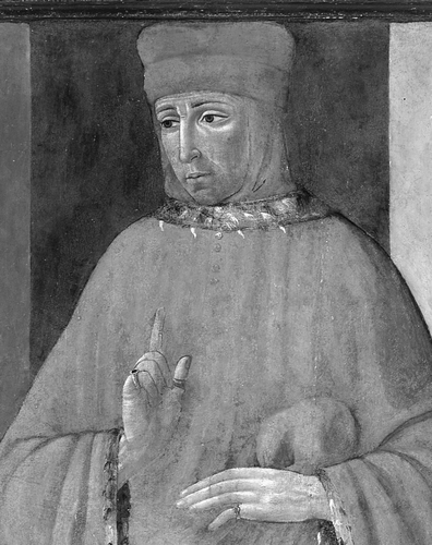
The Datini archive is linked to the career of the Tuscan Francesco di Marco Datini (c.1335–1410) (). Containing approximately 150,000 letters and 600 account registers, the archive testifies to the extent of the activities of a merchant involved in the industrial, banking and commercial sectors within, mostly, Europe and the Mediterranean basin.Footnote4
Fig. 1. Detail from a portrait of Francesco di Marco Datini by Tommaso di Piero del Trombetto, 1490. (Archivio Museo di Palazzo Pretorio, Prato; photograph by Antonio Quattrone.)
Datini started his activities in Avignon and then, on his return to Tuscany in 1382, developed them in Prato (his native town), Pisa, Florence and Genoa. The 1390s saw the deployment of his company’s activities throughout the Mediterranean, particularly in the Iberian area with the establishment of subsidiaries in Barcelona, Valencia and the island of Majorca. All the subsidiaries were independent, held together only by Datini himself as the majority partner of each of them. The remarkably rich correspondence preserved in Prato, where Datini died in 1410, comprises three years of the Lorini Company (1391–1394) and seventeen years of the Datini Company (1394–1411).Footnote5 According to instructions in his will, after Datini’s death all his businesses were liquidated, but the records and correspondence were to be preserved. It took time, however, to wind up the company’s Majorcan activity, which continued into 1411.Footnote6
The Datini archive, with around forty registers and 14,000 letters received in, or sent from, Majorca, contains a significant amount of information about the island from 1391 to 1411. Some of the letters referring to maps produced in Majorca have already been considered by historians of Majorcan cartography and historians of the medieval economy.Footnote7 More recently, Ramon J. Pujades i Bataller quoted from some of them in his vast synthesis of the history of portolan charts in connection with specific points, without, however, discussing the wider context of the archive and its documents and account books.Footnote8
Majorca had been a well-known centre of production of portolan charts since the early fourteenth century.Footnote9 Magnificent charts signed from the island by cartographers such as Angelino Dulcert (active 1330–1345), Guillem Soler (died before 1402), Mecia de Viladestes (Samuel Corcos’s Christian name; active between 1384 and c.1423), and Gabriel de Vallseca (active 1433–1467) can be found in libraries in Europe, and the Datini archive contains many documents relating to them as well as to other Jewish, or recently converted, mapmakers such as Cresques Abraham (d. 1387) and his son Jafuda Cresques (died before 1410), and some cartographers of Genoese origin such as Francesco Beccari (active in Barcelona in 1399, died before 1426).Footnote10
A new exploration of the Datini archive has allowed us to contextualize the full story of some of the charts, from the initial order to final delivery. Our searches have also brought to light previously unknown documents that reveal how the charts were ordered, made, and used in a merchant’s context. Finally, the documents have enabled us to reflect on whether the charts were considered to be ordinary goods for ‘large social diffusion’ or rare luxury artefacts.Footnote11 We start by considering three maps handled by the Datini agents.
The Map Ordered by Antonio delle Vecchie
One group of letters gives an almost full account, from commission to delivery, of a nautical map made in Majorca in 1396. It is a somewhat confused correspondence, however, for letters were written that were not immediately sent while others crossed on the voyage between Majorca and Barcelona. As far as the surviving letters record, the story starts with a Pisan merchant, Antonio delle Vecchie, writing first from Pisa then from Barcelona, to Ambrogio di Rocchi, the Datini Company’s agent in Majorca, about an order for a map already placed with the company ().
Fig. 2. Letter from Antonio delle Vecchie of 13 December 1395 to the Datini Company’s agent in Majorca reminding him of his order for a nautical chart and a pair of dividers. Archivio di Stato di Prato, Datini 1167, 9302300, letter/memorandum Pisa–Majorca, Antonio delle Vecchie to Ambrogio di Rocchi, 1395/12/13, fol. 1r. (Reproduced with permission from Ministero per i beni e le attivitá culturali / Archivio di Stato di Prato.)
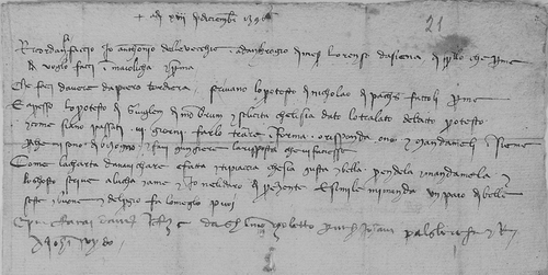
On 13 December 1395, the merchant wrote
I, Antonio delle Vecchie, am reminding Ambrogio di messer Lorenzo da Siena what I want him to do for me in Majorca … If the nautical chart is done and pleases you, if it is accurate and beautiful, take it and send it to me, and the price will be forwarded to Luca [one of Francesco Datini’s business partners in the Iberian area] and me … and in the same way send a pair of nice, good, dividers and do whatever you can about the price’.Footnote12
On 30 December he started another letter asking the agent to send him the map, when it was ready, by the earliest ship available and reminding him, that the map had to be ‘beautiful and good with banners’ (sia bella e buona con le bandiere):
The map … you will send it to me with the first ship available … will be beautiful and good with banners.Footnote13
Antonio appears not to have sent the letter immediately, however, because the last part is dated two weeks later, when he asked again about the map and added further requests:
I have been informed that the map [charta] that you asked to be made is not ready yet; I would like it to be beautiful and good. When it is done, and if you like it, ask someone to verify its accuracy, and if you like it, take it and send it to me as soon as you can with the first ship available; but if you do not like the map, give it up. And if you could see that at the top of the stick there could be a compass, like your own, ask for it. If not, send it to me as you wish and inform me about the cost, and I will give it [the money] here to whomever you say’.Footnote14
As he was writing, though, he received a letter, now lost, from Ambrogio. Dated 29 December 1395, this reached him on 12 January, prompting the second part of his letter with its repeated insistence that the chart should be bella e buona.
A number of points emerge from these exchanges. If the agent Ambrogio was satisfied that the map was well done, he was to ask someone to verify its accuracy (falla riconosciere che sia giusta) before dispatching it.Footnote15 Who such a person might be is unclear, however; did Antonio mean sailors or a cartographical expert? It is also clear that the chart was made on demand; that is, it was to be made (che fai fare) according to the order as opposed to being a ready-made chart taken from stock, and that Ambrogio could decide to abandon the transaction if the map was found to be not good enough (e se non ti piaciesse lasciala stare). The Majorcan chartmaker, we see, was subservient to his client, in this case a merchant.Footnote16
Meanwhile, on 11 January 1396, before Antonio had added the second part of his letter, Ambrogio had already dispatched the map to Barcelona together with a pair of good dividers (un paio di belle seste).The relevant letter, addressed to the agents of the Datini Company in Barcelona, arrived there on 17 January. It reads:
I am sending you, by Antonio Daro’s ship on which Bernat, one of Piero Bariera’s young men, is sailing to Guglielmo di Bagat, one nautical chart with two dividers (II sesti); and it is wrapped in waxed cloth and sealed with your seal. Get it and give it to Antonio delle Vecchie, and ask him on my behalf 4L. and 4s. in Barcelona [money] for 5L. and 12s. of [the money] here, on your and his account, and see to the writings that are needed, and reply.Footnote17
Then, on 22 January, Luca del Sera, Francesco Datini’s business partner in Barcelona, wrote to Ambrogio confirming that he had received the map, but that Antonio was not satisfied (Avemo la carta da navichare d’Antonio de le Vechie e datogliele; assai male se ne contenta).Footnote18 This letter arrived in Majorca on 1 February 1396. Meanwhile, Ambrogio had written another letter, dated 24 January and addressed to the Datini agents in Barcelona, with details of the invoice and mentioning another chart, this time called a mappamundi [papamundi], that he did not know if he was to send to Barcelona.
To ‘Buco’ you would have given 5 florins of Aragon and had 4L. and 4s. from Antonio delle Vecchie and put everything on the account here, and given him the nautical chart that I sent to you through Bariera. I have here the mappamundi, or complete chart. Tell me if I have to send it and not count anything.Footnote19
Thirteen days after Antonio delle Vecchie’s map was dispatched, Ambrogio di Rocchi sent another map to Barcelona, protected by a waxed cloth, together with a compass and a divider. But we do not know who it was meant for.
By In’Cases’s ship we recommend to Francesco Solanes, by which I send you the map with a compass and a divider, covered by a waxed cloth, I am sending you this one and a copy by the King’s ship.Footnote20
Antonio’s reply, written on 8 February, was received in Majorca on 17 March. It confirmed that he was finally satisfied with the ‘beautiful and accurate’ map, received from Bernat: ‘And on this day we received through Bernardo di Bariera my chart that you sent to me, which is very beautiful and accurate and with which I am satisfied’.Footnote21
The eleven surviving letters relating to the chart made in Majorca in 1395/6 (two others, including the initial commission, are known to be missing) have shed light on a number of aspects of the transaction. Most importantly, perhaps, they reveal how long it took between creation and delivery: a mere two months. What has not been confirmed is for whom the map was ultimately destined—the merchant Antonio delle Vecchie, or somebody else in Italy or elsewhere? Considering the precision of the command, it may be thought likely that the map was commissioned for the merchant’s personal use.
One piece of hitherto unnoticed information in one of the Datini account books gives the name of the maker of the map ordered by Antonio delle Vecchie and transported by Bernat Planes. This was Guillem Soler, as noted in the entry, which records that Antonio delle Vecchie paid Guillem Soler in two instalments for the nautical chart sent from Majorca with Bernat Planes, young employee of Piero Bariera: first, on 12 December 1395, he gave 8s.; then on 27th day, same month, 3L and 17s., for a total amount of 4L and 5s.Footnote22
Guillem Soler was a well-known cartographer in Majorca, and two extant charts and a fragment of another are attributed to him.Footnote23 One is Florence, Archivio di Stato, CN 3, dated 1385, and the other is Paris, Bibliothèque nationale de France, Ge B 1131 Res. The chart in Florence does not have many decorative features apart from a few cities, and no banners, whereas the Paris chart is ornamented with gilded islands and red and gold banners. Only the signature Guillmus Soleri civis maioric[arum] me fecit is given, but the chart is traditionally dated ‘ca. 1380’ or ‘between 1368 and 1385’. Could this possibly be the charta da navichare ordered by Antonio delle Vecchie (and therefore to be dated more precisely as 1395)?
Unfortunately, as even for well-known medieval examples such as the Catalan Atlas, we lack precise documentary links between the nautical charts mentioned in the letters and account books and the artefacts that have come down to us and are now stored in public libraries, either because the charts are unsigned or because the suggested date does not fit with the documentation.Footnote24 The question remains unanswered, despite the coincidence of some features of the Paris chart and those requested by Antonio delle Vecchie: ‘beautiful’ (with golden decoration?) and ‘with banners’.
The Map Ordered by Filipozzo Soldani
A second example in the Datini archive of the demand for Majorcan maps is associated with another merchant, Filipozzo Soldani, a Florentine trader living in Barcelona. Soldani’s order for a map from the Datini Company was managed from the Majorcan Company by Luca del Sera. Soldani’s original order has not survived, but the exchange of letters between the Datini Companies of Barcelona and Majorca gives us enough information about it.
For instance, on 3 March 1395 Luca del Sera wrote from Majorca to the Datini agents in Barcelona that he, Luca, would soon be able to buy two charts that were on the point of completion. Both were beautiful to look at, but the price (given in florins) was different for each. Luca requested the agents in Barcelona to ask Soldani to choose between them:
And tell Filippozo that I will have the chart he wants: I will have two in my hands that will be finished in about 8 days. One would cost F.16 to F.18; the other would cost F.10 to F.12 florins. And each one is beautiful. Tell him to inform me which one he wants: the more expensive one, or the cheaper.Footnote25
Filipozzo decided to buy the cheaper one, with a final price of 12 florins. At the same time he asked for a number of smaller items, such as dividers.Footnote26 He then wrote again to Luca at the end of March to say that he knew that the map had been purchased for him (sono avisato de la carta m’ài comperata).Footnote27
The Map Ordered by Luca del Biondo
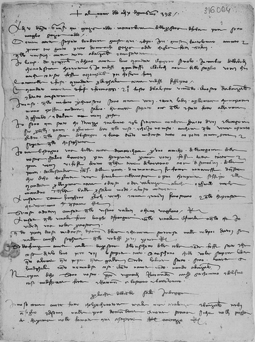
It is certainly the skills of the Majorcan cartographers that the merchant Luca del Biondo was looking for when he ordered a detailed chart for one of his friends in Bruges, Flanders, where he had settled after many exhausting trading voyages in the Mediterranean ().
I need a beautiful nautical chart for a friend of our company, but I would like it more complete: first I would like it all on paper, and then I would like to see in it some parts of the Nertano, that is to say the land of the Saracens near Alexandria, and in the same way some parts of Romania if you have not done it yet. Of the one I mention, do one like yours [?ours], or more complete if it is possible, and send it with the first ship available, from here, or from Valencia to Luca or Guido, so that they can send it to me in some safe package, and take the expense from my account.Footnote28
Fig. 3. Letter from the merchant Luca del Biondo written on 10 June 1398 from Bruges, where he had decided to stay in retirement, asking for a ‘beautiful’ nautical chart that would include the parts of the Byzantine Empire he had visited on his final voyage in the eastern Mediterranean (lines 19 to 25). Archivio di Stato di Prato, Datini 1060, 316064, letter Bruges–Majorca, Luca del Biondo to Datini Company, 1398/06/10. (Reproduced with permission from Ministero per i beni e le attivitá culturali / Archivio di Stato di Prato.)
The previous year, Luca del Biondo had made the voyage from Majorca to Alexandria, departing from the island on the eve of the feast of Saint John the Baptist (24 June 1397).Footnote29 For this journey he had asked the Datini agents in Majorca to find two good pilots capable of guiding them to Alexandria, as Luca del Biondo was not himself a navigator.Footnote30 But the expedition was not particularly successful. He made little profit in Alexandria from the sale of his cargo, and he had problems with the Mamluk authorities that led to his being denounced as a pirate by some ill-wishing Genoese and Venetian merchants. After this, Luca del Biondo had sailed to New Phocea, a Genoese colony on the coast of Anatolia, to take on a cargo of alum.
In November that same year, while on the Genoese island of Chios, in the Aegean Sea, Luca del Biondo wrote to a colleague in Florence relating what had happened in Alexandria.Footnote31 However, his return to Majorca proved to be no more pleasant than the ‘Egyptian’ experience when his ship was intercepted by three vessels off the coast of Syracuse. Eventually, after calling first at Valencia in April 1398, and then at Barcelona, he arrived in Bruges on 5 June 1398, exhausted and suffering from an eye infection. After hesitating about his future, he made the decision to stop travelling and to settle in Bruges. There, he was admitted into the merchants’ company of Diamante and Altobianco degli Alberti.Footnote32 His last known letter was written in Bruges on 4 June 1400.
That Luca del Biondo ordered a chart a mere five days after his return to Bruges (he arrived on 5 June 1398 and wrote the letter on 10 June), merits comment.Footnote33 Clearly, in ordering a map so soon after returning from his journey and already, no doubt, with the idea of retiring from travel at the back of his mind, the map was not wanted in preparation for the next voyage, but rather as a souvenir of journeys made around the eastern Mediterranean to display in Bruges to his partners. He knew what he wanted: the mapmaker has to show the Alexandrian sultanate and Romania, which meant the former Byzantine Empire, that is to say, the regions visited during his last voyage. Moreover, he was evidently confident that the Majorcan cartographers would be able to represent the required details; they might even already have such a map in stock (se fatta non avesse).
Unlike the chart commissioned by Antonio delle Vecchie, which he had insisted was to be drawn especially for him, we see here that potential customers anticipated that the chartmakers would have stocks of ready-made charts from which a particular item could be pulled out on demand. The level of geographical knowledge in Majorca must therefore have been high. Indeed, Luca del Biondo seems to have been prepared to accept an existing map, providing that this map included the regions he specifically asked for. This suggests that all sorts of cartographical models were kept in Majorca, and that these could be improved with information gleaned from travellers and merchants. It is not unreasonable to imagine that Luca del Biondo himself had passed on new geographical details about Alexandria and Romania to some mapmakers in Ciutat of Majorca (now Palma). What is self-evident is that Luca del Biondo ordered a typical Majorcan artefact, highly valued across Europe, because such a work could not be produced in Bruges.
Biondo explained that he needed the map as a gift to a ‘friend of our company’ (ragione della nostra) in Bruges, and that this needed to be a map more ‘complete’ (piu chonpiuta) than his own.Footnote34 Who this friend might have been we are not told. Quite possibly it was a member of the Diamante et Altobianco degli Alberti company, of which he says ‘they are nice people’ (sono gienti dolci) and into which he was just being admitted.Footnote35
Ordinary Goods or Luxurious Artefact?
What kind of ‘maps’ were those that are mentioned in the Datini archives? Do we infer that they differed from ordinary navigational charts—the two words (mappamundi and charta de navegare) appear to have been used indiscriminately in the correspondence? Did maps have greater aesthetic value than charts, or vice versa?Footnote36
Many solid points of interest have emerged from the Datini correspondence. We have seen, for instance, how nautical charts were produced, sold and transported and how, although charts in the fourteenth century may usually have been drawn on parchment, as Pujades i Bataller maintains, there were occasions when paper was specifically requested, as the Tuscan expression tutta carta [all paper] indicates. Admittedly, the vocabulary used in the documents is not always clear: with the request vorei fosse tutta carta, was Luca del Biondo asking for a map ‘wholly on paper’ or ‘the whole chart’, that is, one that included more than the Mediterranean Sea?Footnote37
We have also seen how charts were rolled up (rivolta), sometimes around a wooden stick (bastone) to which a compass (bussola) could be fixed, as Antonio delle Vecchie asked of Ambrogio di Rocchi. Further examples indicate this was general practice.Footnote38 The roll was then wrapped in cloth (chanovaccio) and the bundle tied with parchment thongs or cords (legato), traces of which are still visible on some extant charts. Finally the rolls were ‘covered with waxed fabric’, certainly to waterproof them (in n’uno incerato; the word incerato designates a cloth covered with wax).Footnote39 The use of cloth, ties, and wax shows that these charts were not intended to be used on board ship and that, on the contrary, they were carefully packed to ensure safe transit.Footnote40 Silk, another precious commodity, was managed in exactly the same way. Once purchased, the silk was packaged in tangled skeins (scagne) that were grouped into bundles (fardello), which were protected by several layers of canvas (camicie), waxed fabric (incerato) and tied around with cord.
Not every map or chart was necessarily rolled up; those delivered to Baldassare degli Ubriachi in 1400 included a ‘mappamundi tied and packed into a chest and a mappamundi untied’ (I apomondo legato e amagl[i]ato in Ia chassa, e I apomondo dislegato) together with three compasses (bussole).Footnote41 Apart maybe from this reference, nothing in the Datini letters appears to refer to a book of several charts or to a single world map divided into pieces glued onto wooden panels in the style of the Catalan Atlas. Atlases of nautical charts seem to have been a Venetian rather than a Majorcan product.Footnote42
This documentation adds some new light on the different uses, according to the individual customer, of portolan charts. Some certainly were, as is often insisted, destined for shipboard use. Those sold and sent with a compass (bussola) and a pair of dividers (un paio di belle seste), like those mentioned above, seem intended for use as practical navigational instruments, especially given the qualification in the commission that the charts must be ‘good and exact’ and their accuracy verified (riconosciere che sia giusta) by competent mariners or cartographers. In the case of Antonio delle Vecchie’s chart, the compass was fixed to the map in a way that permitted them to be used together.Footnote43 But the beautiful map made by Guillem Soler, one of the kind now treasured by the Bibliothèque nationale de France, was surely not intended for navigation but to be added to a collection of beautiful objects associated with the sea in some merchant’s house.Footnote44 We know from probate and other inventories that merchants often owned such items. Giovanni Maringhi, for example, a Florentine merchant living in Ottoman Constantinople at the beginning of the sixteenth century, had a chart on display in his house when he died.Footnote45
Finally, interesting information about prices has also emerged. These varied according to whether the requested item was available for general sale or was to be created on demand. The distinction was also made between charts ‘only for sailors’ and the more decorative ones that nonetheless still had the characteristics of an accurate nautical chart. Indeed, in another group of letters, addressed to the agents of the Datini Company in Barcelona in February 1408, the Datini agents in Majorca underline the difference between a map that was ‘only for mariners (se non per marinieri), ‘perfect for navigation’ (perfetta da navigare) but without decoration, and one painted with heraldic devices (dipinta l’arme delle terre) representing the different political units.
We bought a navigation map and it is good, but it can only be used by sailors. It cost 4 reals. Another time we would have bought it [for] only 3 reals, but nobody else makes them except the same Bizaro, who is fantastic. The one I bought in Cristofano’s time, he would want now 10 florins of it.Footnote46
By Boraccino I send you the navigation map rolled up in a waxed cloth; have it delivered to you. Count 4R. on our account … Bizaro says that for whoever wants it, it will cost him 5R., because there is no other master than him, and it is perfect to sail with but there are no coats of arms painted on the land as you would like, he would want 8R. for it. If this one dies, no one will be able to navigate! God save him!Footnote47
The writer drew attention, too, to a significant increase in prices; from 3 or 5 reals for a single map, to 8 reals for a decorated one.Footnote48 The higher price was demanded by the ‘the fantastic Bizaro’ (Bizaro usato, ch’è fantastico), whose reputation was endorsed by the merchants when they claimed—possibly with some exaggeration—that no one else would produce such good charts and there would be no navigation for lack of them.Footnote49
Our study of the archive of the Datini trading business has yielded valuable insight into the material aspects of the map trade at the close of the fourteenth century. Apart from specific details relating to the commissioning, purchase and dispatch of the charts on a highly personal basis, perhaps the most important outcome has been confirmation that portolan charts were integral aspects of international commerce.Footnote50 The charts handled by the Datini firm ranged considerably in function and appearance. Some were sold together with navigational instruments such as compasses and dividers. Others were explicitly ordered as ornamented gifts, and particular attention was paid to their packing and shipping to as far afield as northern France, England and Flanders.Footnote51 Yet others were also decorated but destined for personal use. One aspect of their appeal, it could be said, lay in the possibility of personalizing them.
While the debate as to exactly who on board a ship at the end of the fourteenth century would have actually used the navigational data presented on the charts remains unresolved, the Datini archive clearly reflects the desire of a wider and more socially refined and educated group of people to own, for one reason or another, a souvenir of the sea with which they were personally acquainted. At the same time, consciously or unconsciously, the merchant purveyors of these charts were helping to advance geographical knowledge, partly by ensuring the dissemination of their cartographical goods and partly by their own input as they shared their own navigational experience and knowledge gained through their commercial encounters and trading networks on their return to the home port.
Notes
1. Tony Campbell, ‘Portolan charts from the late thirteenth century to 1500’, in The History of Cartography, vol. 1: Cartography in Prehistoric, Ancient and Medieval Europe and the Mediterranean, ed. J. B. Harley and David Woodward (Chicago, University of Chicago Press, 1987), 371–463; Tony Campbell, ‘Census of pre-sixteenth century portolan charts’, Imago Mundi 38 (1986): 67–94 (the revised census is on the current MapHistory website); Patrick Gautier Dalché, Carte marine et portulan au XIIe siècle. Le Liber de existencia riveriarum et forma maris nostri mediterranei (Rome, École Française de Rome, 1995); Ramón Pujades i Bataller, Les cartes portolanes: la representació medieval d’una mar solcada (Barcelona, Institut Cartogràfic de Catalunya, 2007); Philipp Billion, Graphische zeichen auf mittelalterlichen portolankarten: ursprünge, produktion und rezeption bis 1440 (Marburg, Tectum, 2011).
2. Pujades i Bataller, Les cartes portolanes (see note 1), 452–63; Patrick Gautier Dalché, ‘L’usage des cartes marines aux XIVe et XVe siècles’, Spazi, tempi, misure e percorsi nell’Europa del Bassomedioevo. Atti del XXXII Convegno storico internazionale, Todi, 8–11 ottobre 1995 (Spoleto, 1996), 97–128; Patrick Gautier Dalché, ‘Cartes marines, représentations du littoral et perception de l’espace au Moyen Age. Un état de la question’, Castrum 7 (Rome, 2001): 9–33; Patrick Gautier Dalché, ‘Les cartes marines, origines, caractères, usages: à propos de deux ouvrages récents’, Geographia Antiqua 20–21 (2011–2012): 215–27; Catherine Hofmann and Emmanuelle Vagnon, eds., Cartes marines: d’une technique à une culture, 13e–18e siècle (revue Cartes & Géomatique 216 (June 2013)); Emmanuelle Vagnon, ‘La représentation cartographique de l’espace maritime’, in La Terre. Connaissance, représentations, mesure, ed. Patrick Gautier Dalché (Turnhout, Brepols, 2013): 443–503. The First International Workshop, held in Lisbon 6–7 June 2016, and the Second International Workshop, 7–8 June 2018, discussed ‘The Origin and Evolution of Portolan Charts’.
3. Patrick Gautier Dalché, ‘La carte marine au Moyen Age: outil technique, objet symbolique’, in The Sea in History, vol. 2: The Medieval World / La mer dans l’histoire, vol. 2: Le Moyen Âge, ed. Christian Buchet and Michel Balard (Woodbridge, Boydell and Brewer; Paris, Océanides, 2017), 101–14.
4. The entire commercial and private correspondence has been scanned and is available on the website of the Datini archive in Prato: http://datini.archiviodistato.prato.it/www/. On the Datini documentation, see Bruno Dini, ‘L’Archivio Datini’, in L’impresa, industria, commercio, banca secc. XIII–XVIII (Atti della ‘Ventiduesima Settimana di Studi’, 30 aprile–4 maggio 1990, Istituto Internazionale di Storia Economica ‘F. Datini’, Prato), ed. Simonetta Cavaciocchi (Florence, 1991), 45–60; Jérôme Hayez, ‘L’Archivio Datini, de l’invention de 1870 à l’exploration d’un système d’écrits privés’, in Le carteggio Datini et les correspondances pratiques des XIVe–XVIe siècles, ed. Jérôme Hayez, Mélanges de l’École française de Rome—Moyen Age 117:1 (2005): 121–91. A highly readable but still scholarly account in English of Datini is Iris Origo, The Merchant of Prato: Francesco di Marco Datini, 1335–1410 (New York, Alfred A. Knopf, 1957).
5. On the emergence and the structure of Florentine merchant companies, see Federigo Melis, Aspetti della vita economica medievale (Siena, Monte dei Paschi, 1962); Ingrid Houssaye Michienzi, Datini, Majorque et le Maghreb. Réseaux, espaces méditerranéens et stratégies marchandes (Leiden, Brill, 2013).
6. Four other letters from the island, however, are dated 1412–1413.
7. As in Federigo Melis, Documenti per la storia economica dei secoli XIII–XVI (Florence, Olschki, 1972); Giampiero Nigro, Mercanti in Maiorca. Il carteggio datiniano dell’Isola (1387–1396), 2 vols. (Florence, Le Monnier, 2003).
8. Pujades i Bataller, Les cartes portolanes (see note 1), 99–100, 435–36, documents 98, 99, 101, 104. See Ingrid Houssaye-Michienzi and Emmanuelle Vagnon, ‘Cartographie commerciale et circulations marchandes à Majorque au XVe siècle’, in Centres pluriculturels et circulation des savoirs (XVe–XXIe siècles), ed. Françoise Richer and Stéphane Patin (Paris, Michel Houdiard, 2015), 27–44.
9. Julio Rey Pastor and Ernesto Garcia Camarero, La cartografia mallorquina (Madrid, Departamento de Historia y Filosofia de La Ciencia, Instituto Luis Vives, 1960).
10. Gabriel Llompart, ‘La cartografia mallorquina del siglo XV. Nuevo hitos y rutas’, Bolletí de la Societat Arqueològica Lulliana 34 (1975): 438–65; Jaume Riera i Sans and Gabriel Llompart, ‘Jafudà Cresques i Samuel Corcós. Més documents sobre els jueus pintors de cartes de navegar (Mallorca, s. XIV)’, Bolletí de la Societat Arqueològica Lulliana 40 (1984): 341–50; Gabriel Llompart, ‘Registro de los cartógrafos medievales activos en el puerto de Mallorca’, Anuario de Estudios Medievales 27:2 (1997): 1117–48; Pujades i Bataller, Les cartes portolanes (see note 1), 486–87. The Datini account book for Barcelona refers to ‘Maestro Riba, cristiano novello, maestro di charte di navichare’ and ‘Maestro Francesco di Genova, dipintore di charte da navichare’. In a contract, Beccari describes himself as ‘Franciscus Becarius, magister cartarum navigandi, civis Janue’; see R. A. Skelton, ‘A contract for world maps at Barcelona, 1399–1400’, Imago Mundi 12 (1968): 107–13; a map signed ‘Franciscus Becharius civis Janue’, dated 1403, is kept in New Haven, Yale University, Beinecke Rare Book and Manuscript Library, 1980.158; Pujades i Bataller, Les cartes portolanes (see note 1), 63.
11. Pujades i Bataller, ‘Les cartes de navigation. Premières cartes à large diffusion sociale’, in L’Age d’or des cartes marines. Quand l’Europe découvrait le monde, ed. Catherine Hofmann, Hélène Richard and Emmanuelle Vagnon (Paris, BnF-Seuil, 2012), 60–67. For a critique of Pujades’s interpretation, see Gautier Dalché, ‘La carte marine au Moyen Age’ (note 3), 102.
12. ‘Ricordansa faccio Io Anthonio delle Vecchie ad Anbrogio di meser Lorenzo da Siena di quello che per me vogl[i]o facci in Maiolicha … Come la charta da navichare è fatta e ti piaccia, che sia g[i]usta e bella, prendela e mandamela e lo ghosto seque a Lucha e a me … e simile mi manda un paio di belle seste e buone e del pregio fa lo megl[i]o puoi’. Archivio di Stato di Prato, Datini (hereafter Datini) 1167, 9302300, letter/memorandum Pisa–Majorca, Antonio delle Vecchie to Ambrogio di Rocchi, 1395/12/13, fol. 1r.
13. ‘La carta … la mi mandi per lo primo buon pasagio … sia bella e buona con le bandiere’. Datini 1047, 1101324, letter Barcelona–Majorca, Antonio delle Vecchie to Ambrogio di Rocchi, 1395/12/30, closed 1396/01/14, received 1396/01/22, fol. 1r. Quoted from the first part of the letter dated 1395/12/30.
14. ‘Che la charta che fai fare per ora non sia ancora fatta sono avizato, piacierami sia bella e buona; quando sarà fatta e ti piaccia, falla riconosciere che sia g[i]usta e se ti piacia pigl[i]ala e mandamela come prima puoi la possa mandare per la nave vene sarà; e se non ti piaciesse lassala stare … E se potessi fare che nel chapo del bastone ci fosse una bussola a modo de la tua, fallo. Se non, mandala come ti pare e avizami del ghosto e daròli qua a chi dirai’. Datini 1047, 1101324, letter Barcelona–Majorca, Antonio delle Vecchie to Ambrogio di Rocchi, 1395/12/30, closed 1396/01/14, received 1396/01/22, fol. 1r. [Quotation from the second part of the letter not written until 1396/01/14]
15. In his De navigatione (New Haven, Yale University, Beinecke Rare Book and Manuscript Library, MS 557, fol. 61v–62v), Benedetto Cotrugli explains how to check the accuracy of a nautical chart by the correctness of the orientation of the wind directions of the network: volendo agiustare la carta de navigare o vero cognoscere sel’è giusta … (quoted in Pujades i Bataller, Les cartes portolanes (see note 1), 475). It is unclear, though, if Cotrugli was describing the kind of checking requested by Antonio delle Vecchie.
16. This accords with Pujades’s remark (Les cartes portolanes (see note 1), 440), that ‘everything depended on the client, on the use to which he wanted to put the chart, and on the price he was prepared to pay’.
17. ‘Per questo legno d’en Antoni Daro in sul quale viene Bernat, giovane di Piero Bariera, a Ghuglielmo di Bagat, vi mando I charta da navichare con II sesti; ed è involgl[i]ata d’incerato e sugelata di vostro sugello, la qual farete d’avere, e la date a ‘Ntonio delle Vecchie, e per me li domandate, con I sua sia in questa L.4 s.4 barzalonesi per L.5 s.12 qui a vostro e suo conto, e auti ne fate la scritta bixogna e Rispondete’. Datini 886, 113527, letter Majorca–Barcelona, Ambrogio di Rocchi to Datini Company, 1396/01/11, fol. 1r. (copy in Datini 886, 113528). Bernat was Bernat Planes, whose surname is given in another of Ambrogio’s letters, written 13 days later: Datini 886, 113531, letter Majorca–Barcelona, Ambrogio di Rocchi to Datini Company, 1396/01/24). Piero Barriera (Italian version of Pere Barrera) was a Majorcan money changer. The price of the chart is given in Barcelona currency after converting the price established in Majorca in Majorcan currency.
18. Datini 1046, 315280, letter Barcelona–Majorca, Datini Company to Ambrogio di Rocchi, 1396/01/22, fol. 2r.
19. ‘Al Bucho [Leonardo de Johan] arete dato F. V aragonesi e d’Antonio Vechie auto L.4 s.4, e ponete a chonto qui tutto, e datoli la carta da navichare che per in Bariera vi mandai. Il papamundi, o charta conpiuta, che sia ch’io tengho, dite vi si mandi e nulla si chonti’. Datini 886, 113532, letter Majorca–Barcelona, Ambrogio di Rocchi to Datini Company, 1396/01/24, fol. 2r.
20. ‘Per In’ Cases acomandammo a Francesco Solanes, per chi vi mando la carta colla bossola e la sesta coperto d’incerato, vi mandammo questa [lettera] e copia per la nave del Re’. Datini 886, 113532, letter Majorca–Barcelona, 1396/01/24, fol. 5v; and ibid., 113531, letter Majorca–Barcelona, 1396/01/24, fol. 5v.. The same reference appears in two copies of the same letter; commercial letters were often sent in duplicate to be sure that at least one would reach its destination.
21. ‘E ditto dì per Bernardo di Barera avemmo la mia charta che mi mandaste, la quale è molto bella e g[i]usta e contentomene’. Datini 1047, 1101325, letter Barcelona–Majorca, Antonio delle Vecchie to Ambrogio di Rocchi, 1396/02/08, fol. 1r. Antonio thanks Ambrogio again in his next letter, dated 2 March (ibid., 1101326).
22. ‘Antonio de le Vechie de’ dare a dì 12 di dicie[n]bre [1395] prestò gli abiamo contanti p**** di Ia carta da navichare L.- s.8 d.-. A dì 27 detto per chonpimento di L. 4 s. 5 per Ia charta da navichare ebe Guilem Solieri gli mandiamo per Bernat Planes, giovane di Piero Bariera, L. 3 s. 17. Mesi a uscita a c.196’. Datini 1027, Quaderno di balle B, Majorca, 1395, fol. 96v.
23. Pujades i Bataller, Cartes portolanes (see note 1), 440 n.181. Guillem Soler is mentioned in a document of 1368 as magistro instrumentorum navigandi, which Pujades takes to be the Latin equivalent of mestre de cartes de navegar. See M. Baig i Àleu, ‘Un nuevo documento sobre Guillem Soler y la cuestión de la cartografia Mallorquina’, Lull, 24 (2001): 587–603. Pujades i Bataller, La cartografia medieval i Barcelona. L’adquisició d’un fragment de Guillem Soler, Barcelona, Ajuntament de Barcelona-Institut de Cultura (Museu d’Història de Barcelona, 2015).
24. Catalan Atlas, Paris, Bibliothèque nationale de France, Ms. Espagnol 30. This unsigned atlas is only partly linked by the documentary evidence to Cresques Abraham: see Ernest T. Hamy, ‘Cresques lo Juheu. Note sur un géographe juif catalan de la fin du xive siècle’, Bulletin de géographie historique et descriptive (Paris, 1891): 221; Jaume Riera Sanz, ‘Cresques Abraham, Judio de Mallorca, maestro de mapamundis y de brújulas’, in El Atlas Catalàn de Cresques Abraham. El primer atlas del Mundo. Primera edición completa en el sexcentésimo aniversario de su realización, 1375–1975 (Barcelona, 1975), 18.
25. ‘E di’ a Filippozo [Soldani] che io arò la carta vole: ònne 2 ale manni che sarano conp[i]uta fra 8 dì. L’una costerebe F. 16 in 18; l’altra costerebe F. 10 in 12. E ciaschuna è bella. Digli m’avisi quella vole: o la di più danari, o la di meno’. Datini 886, 901294, letter Majorca–Barcelona, Luca del Sera to Datini Company, 1395/03/03, fol. 2r.
26. Datini 886, 901299, letter Majorca–Barcelona, Luca del Sera to Datini Company, 1395/03/18, fol.1r.
27. Datini 1046, 6000568, letter Barcelona–Majorca, Filipozzo Soldani to Luca del Sera, 1395/03/30, fol. 1r.
28. ‘Io are’ bisongnio una bella carta da navichare per uno amicho della ragione della nostra, salvo la vorei più chonpiuta: prima vorei fosse tutta carta, e più vorei vi fosse dentro qualche terre del Nertano, cioè di saraini delle parti d’Allisandra, e così delle parti di Romania se fatta non avesse. Di questa ch’io dicho togliete una simile alla vostra [?nostra], o più chonpiuta se ssi può, e lla mandate per lla prima nave, o di costì, o da Valenza a Lucha o Ghuido me la mandino in qualche balla per salvo modo, e’l costo mi traete’. Datini 1060, 316064, letter Bruges–Majorca, Luca del Biondo to Datini Company, 1398/06/10.
29. Datini 887, 901262, letter Majorca–Barcelona, Luca del Biondo to Datini Company, 1397/06/23, fol. 1r.
30. Datini 1048, 316062, letter Barcelona–Majorca, Luca del Biondo to Datini Company, 1397/04/29, fol. 1r.
31. Datini 704, 510477, letter Chios–Florence, Luca del Biondo to Manno d’Albizo degli Agli, 1397/11/12, fol. 1r.
32. Datini 979, 802147, letter Bruges–Valencia, Luca del Biondo to Luca del Sera, 1398/07/05, fol. 1r.
33. Datini 1060, 316064, letter Bruges–Majorca, Luca del Biondo to Datini Company, 1398/06/10. The letter arrived in Majorca on 7 July.
34. For the letter, see note 28. It is unclear if by più chonpiuta Biondo meant it was to show a geographically more extensive area than on his map, or include more geographical details, or have more decoration.
35. Datini 979, 802147, letter Bruges–Valencia, Luca del Biondo to Luca del Sera, 1398/07/05, fol. 1r.
36. See Kevin Sheehan, ‘Aesthetic cartography: the cultural function of portolan charts from 1300 to 1700’, Imago Mundi 65:1 (2013): 133–34; Gautier Dalché, ‘La carte marine au Moyen Age’ (see note 3).
37. Pujades i Bataller, Les cartes portolanes (see note 1), 440.
38. Datini 1047, 1101324 (see above at note 13). A previously unknown reference to a map rolled around a stick is found in the inventory of the estate of Jean d’Angoulême, 1467, which describes ‘A nautical map on parchment, rolled around a baton, divided into all lands and maritime countries, inscribed at the top ‘Anthony’s large ship was 32 fathoms long and its mast was 31, and carried 1500 tons laden’ [Une Mappe marine en parchemin, enrollee en ung baston, divisee par toutes terres et païs de mer, escript en teste La grant nef de anthon avoit 32 brasses de long et le mast 31 et portoit 1500 tonnaux poisant’]. See, Gilbert Ouy, La librairie des frères captifs les manuscrits de Charles d’Orléans et Jean d’Angoulême (Turnhout, Brepols, 2007), 67: Inventaire de 1467 (C), no. 141. We owe this reference to Maxence Hermant, Bibliothèque nationale de France.
39. Datini 886, 113527 and 113528, letters Majorca–Barcelona, 1396/01/11, fol. 1r (two copies of the same letter). See also Pujades i Bataller, Les cartes portolanes (note 1), 435, document 99.
40. This kind of packaging, with cloth and wax, would have protected the fragile colours of valuable maps well. For further examples of packaging, see Pujades i Bataller, Les cartes portolanes (note 1), 461, who does not, however, notice the use of the wax.
41. Datini 825, Quaderno di ricordanze E, Barcelona, 1400/08/13, fol. 18v. The text in full is ‘Ricordo che dem[m]o a Baldasare Ubriacho. I apomondo [sic] legato e amagl[i]ato in Ia chassa, e I apomondo [sic] dislegato, i quali ci avea fato per lui maestro Franciescho genovese, portò Uberto [empty space] fu con lui, con I bastagio e più III busole da apomondi [sic]’ [I remember that we provided Baldassare Ubriachi with one map bound and placed in a chest, and one map unbound, both made for him by maestro Francesco genoese; Uberto brought it with him, with a stick and three map’s compasses].
42. An example of a Venetian atlas on boards is preserved, together with its leather slipcase, in the Bodleian Library, Oxford, Ms Douce 390; see Eva Oledzka, ‘A Venetian set of portolan charts’ in Treasures from the map room. A journey through the Bodleian Collections, ed. Debbie Hall, Oxford, Bodleian Library, 2016: 86-87. The luxurious nature of these maps with their intricately embossed and highly polished leather case indicates that they were not intended for a sailor’s use at sea. In general, it is difficult to decide if references to binding (legato) in the letters indicate the binding of boards into a book as opposed to the ties of a rolled map: Pujades i Bataller, Les cartes portolanes (see note 1), 462. According to the contracts cited by Skelton, ‘A contract for world maps at Barcelona, 1399–1400’ (see note 10), 109, the maps ordered by Ubriachi in 1399–1400 were large, and at more than 150 × 300 cm, far too big to be presented in book form.
43. See note 14 above.
44. On map collections in personal libraries, see John N. Hillgarth, Readers and Books in Majorca, 1229–1550 (Paris, 1991); Jacques Paviot, ‘Les cartes et leur utilisation à la fin du Moyen Age. L’exemple des principautés bourguignonnes et angevines’, Itineraria, 2 (2003): 201–28; Pujades i Bataller, Les cartes portolanes (see note 1), 428–39; Emmanuelle Vagnon, Cartographie et représentations occidentales de l’Orient méditerranéen (du milieu du XIIIe à la fin du XVe siècle) (Turnhout, Brepols, 2013), 225–27, 231–32.
45. The inventory taken after Maringhi’s death in 1507 mentions ‘una charta da navichare chon sua fornimenti’ [a map with its instruments]. Cambridge, Harvard University, Harvard Business School, Baker Library Special Collections, Medici Family Collection, MS495C, fol. 111.
46. ‘Abian chonprato Ia charta da navichare ed è buna ma non n’è se non per marinieri; chosta Reali quatro, altra volta s’arebe auto per 3, ma non c’è chi lle facci se non el Bizaro usato, ch’è fantasticho. Quella che chonprai quando c’era Cristofano, ne vorebe x fiorini’. Datini 891, 902468, letter Majorca–Barcelona, Datini company to Datini company, 1408/02/04, fol. 1v. Pujades i Bataller suggests that ‘Bizaro’ could be another name for Samuel Corcos / Mecia de Viladestes or, possibly, Rafel Soler; Pujades i Bataller, Les cartes portolanes (see note 1), 436, 488.
47. ‘Per detto Boraccino vi mandiamo la charta da navichare rivolta in n’uno incerato; fatelavi dare; R. quatro ne ponete a nostro conto … dice el’ Bizaro che chi ne vorà gli chostera di simili R. 5, che altro maestro non c’è che lui, e ll’è perfetta da navichare ma non è dipinta l’arme delle terre chome voresti che R. 8 ne vorebe. Se chostui morà non si potrà più navichare! Dio il ghuardi!’. Datini 891, 902471, letter Majorca–Barcelona, Datini Company to Datini Company, 1408/02/18, fol. 1v.The same references, with less detail, appear in Datini 891, 902473, letter Majorca–Barcelona, Datini Company to Datini Company, 1408/02/19, fol. 1r.
48. The price of a chart varied over time and according to the quality of the decoration, ranging from a couple of florins for the charts recorded in the Datini letters to 150 golden Aragonese florini in 1382 for a mappamundi made for the king. Prices are discussed in Pujades i Bataller, Les cartes portolanes (see note 1), 279–80, 497–501; and Pujades i Bataller, ‘Les cartes de navigation’ (see note 11), 60–67, at 62. See also the comment on the cost of Catalan and Majorcan maps compared with the price of the Venetian mappamundi in Angelo Cattaneo, Fra Mauro’s Mappa Mundi and Fifteenth Century Venice (Turnhout, Brepols, 2011), 292–97.
49. Datini 891, 902471, letter Majorca–Barcelona, 1408/02/18, fol. 1v. The same reference, with fewer details, is made in ibid., 902473, letter Majorca–Barcelona, Datini Company to Datini Company, 1408/02/19, fol. 1r. Houssaye-Michienzi and Vagnon, ‘Cartographie commerciale’ (see note 8), 34. Gautier Dalché notes that the remark could have been ‘ironical’ and not intended to be taken literally as a reaction to the exaggerated price asked by Bizaro in pretending to be the ‘last’ capable mapmaker available. Gautier Dalché, ‘La carte marine au Moyen Age (see note 3), 107.
50. The individual nature of the transactions explains the importance of personal letters rather than account books as documentation. Payment, we have seen tended also to be made directly to the mapmaker and through the private intermediary.
51. Luxury Catalan and Majorcan maps were greatly appreciated in the royal courts of the day and were sometimes specially made for this particular audience. This was the case with the four mappamundi ordered by Baldassare Ubriachi from Francesco Beccari, 7 June 1399, with the help of Simone d’Andrea Bellandi, the Datini Company’s director in Barcelona. On 14 July, and once again on 20 August, Ubriachi wrote that he was waiting impatiently for Francesco Beccari’s work, because he was preparing to travel to Navarre, England and Ireland. Michaelmas (29 September) seemed favourable for selling luxury goods, and he was certainly keeping one of the maps aside for the king of England. Datini 1111, 6100265, letter Saragossa–Barcelona, 1399/07/14, fol. 1r; Skelton, ‘A contract for world maps at Barcelona, 1399-1400’ (see note 10); Pujades i Bataller, Les cartes portolanes (see note 1), 430, document 27.