Abstract
Threshold concepts are those transformative concepts in a discipline that are often difficult to understand when first encountered, but when mastered they transform students, both epistemologically and ontologically in relation to the discipline. Using the characteristics of threshold concepts, existing curricula and summative content analysis of the text in published seminal geographical information systems (GIS) research papers, this study identifies three key GIS concepts as threshold concepts which are map-scale, data model and interoperability. This study further links these concepts with other key GIS concepts with the aim of providing a means for laying conceptual foundation among novice GIS learners.
Background
Geographical information systems (GIS) can be considered as the modern form of the geography discipline's spatial tradition, which has been identified as one of four traditions of geography (Pattison, Citation1964). GIS is now well recognized as a science (Goodchild, Citation1992), and can be considered as a relatively new and emerging area. Similar to the base discipline of geography, which has been recognized as multidisciplinary for a long time (Fenneman, Citation1919), GIS has the characteristic of being able to be integrated across diverse curricula. On the one hand, GIS is considered as a key factor to augment students' graduate attributes, such as spatial thinking (Lee & Bednarz, Citation2009) whereas on the other hand, the modern technological breakthroughs have made GIS easier and more affordable to use. As a consequence, there is a continuous worldwide increase in GIS users and students' enrolment in GIS courses.
With today's easy-to-use GIS tools, the GIS can be used with superficial knowledge, with what is described as “buttonology” or a point-and-click procedure (Marsh, Golledge, & Battersby, Citation2007), and without attaining the conceptual understanding of underlying theories that are essential for longer term success. One of the major requirements to address the pedagogical challenge in the whole geographical science discipline, identified in the recent NRC report, is finding ways to deepen students' grasp of the structure and function of geographical technologies, including an understanding of their appropriateness for different scenarios (NRC, Citation2010).
While discussing the usefulness of laws of geographical information science, it is acknowledged that the principles behind the tools form the foundation of most learning in science, and for GIS, the underlying principles guide the development of the technology (Goodchild, Citation2004). In this direction, the importance of key characteristics of geographic data-sets has been emphasized (Goodchild, Citation1992), and a two-way relationship between the science behind GIS and the technology component has been recognized (DiBiase et al., Citation2006). However, the theoretical part is often disregarded by GIS users, especially when a surface learning approach is adopted, because GIS is dominated by the technology component, comprising both user-friendly software and hardware. The term, “surface learning approach” is widely used in educational research to specify one particular learning approach adopted by students to pass a course without having a conceptual shift and influence on their practices (Bradbeer, Citation1996; Srivastava & Tait, Citation2012). Moreover, it is not uncommon to notice GIS users using spatial tools to address real-world problems without having a sound conceptual understanding, especially in situations where the application is driven by software.
Several efforts have been made towards designing GIS curricula (Goodchild & Kemp, Citation1992; Kemp & Goodchild, Citation1992; Unwin, Citation1997) that leads to the core curriculum for GIS (NCGIA, Citation2000); however, the curriculum for GIS education can still be considered as evolving. Although there is a model of GIS content knowledge aimed at regulating GIS teaching, for example, the Geographical Information Science and Technology Body of Knowledge (GIS&T BoK), DiBiase et al. (Citation2006) identify key knowledge areas of the discipline and this is used across the world for designing GIS and other spatial science curricula. The GIS&T BoK identifies and equally emphasizes the three aspects of GIS: the GIS theory, the GIS technology and the GIS application. However, the discipline-based body of knowledge is not meant for organizing contents in an appropriate hierarchy and can only provide a list of topics for a curriculum.
For the judicious use of GIS by its users, GIS learning should be considered as much more than the accrual or collection of bits of knowledge or tools, each of which can be used to address a different kind of a real-world issue. The entirety of GIS is more than the sum of its parts, and therefore, the students' GIS learning should be directed towards portraying a bigger picture, which can only be achieved with a good conceptual foundation of the discipline. A similar consideration has been given to the training of techniques courses within geography/geographical sciences in the NRC report which raises one of the following strategic questions to institutions offering advanced degrees in geography:
Are the techniques courses being offered sufficiently grounded in concepts and theory so that students see the geographical sciences [including GIS] as a way of thinking, not just a set of computer program (NRC, Citation2010, 120)?
The threshold concepts framework can play a vital role in achieving this goal. Threshold concepts were first proposed for the discipline of economics (Meyer & Land, Citation2003); however, later investigations revealed that the notion of threshold concepts is applicable across other disciplines too (Land, Meyer, & Smith, Citation2008).
Threshold concepts are defined as those which have a profound effect on the students' understanding of a specific discipline and its discourse (ways of thinking and modes of reasoning and explanation). The threshold concepts framework draws eclectically from a number of theoretical perspectives as well as theories and recognizes the ways that students learn within a diverse range of disciplines. In doing so, it provides new opportunities for research into student learning. For example, certain concepts in various disciplines act as thresholds in the sense that they need to be mastered before further progress can be made in that discipline. These concepts are similar to a conceptual gateway, whereby students traverse through a liminal space (limen is Latin for “threshold”) before they can become an expert in the discipline. Identifying threshold concepts, and their subsequent inclusion in curriculum design within a discipline, offers a fresh way of thinking about research collaboration among students, academics, educational researchers and developers (Cousin, Citation2010).
The threshold concepts framework can be utilized to develop a much needed approach to transactional curriculum inquiry models in GIS education. A transactional curriculum inquiry model, including the effective use of threshold concepts, aids development towards a transformative pedagogy; that is, pedagogy centred in the authority of the subject specialist, grounded in the being of the student as well as captured by the educational research specialist (Cousin, Citation2008). The threshold concepts framework facilitates an active and dynamic approach for co-inquiry between subject experts, students and educational researchers (Cousin, Citation2008). This enables shared understandings of difficulties about a concept expected to be faced by students and the ways to master them suggested by discipline expert.
Using the characteristics of threshold concepts (Flanagan, Citation2012), GIS&T BoK (DiBiase et al., Citation2006), NCGIA core curriculum (NCGIA, Citation2000) and a summative content analysis (Hsieh & Shannon, Citation2005) of criteria-selected seminal published work in GIS, this paper identifies three threshold concepts that should be mastered before using the user-friendly technological component of GIS. The three identified threshold concepts are map-scale, data model and interoperability.
The next section describes the threshold concepts framework, their characteristics, effectiveness and their relationship with other learning theories. The subsequent section describes the methods used for supporting identified threshold concepts. Thereafter, the paper discusses the identified threshold concepts and their relationships with other GIS concepts, and how after mastering the threshold concepts the learner can be transformed to become an expert. The concluding section discusses the significance of the identified threshold concepts for the understanding of GIS concepts.
Threshold concepts framework
A threshold concept is dissimilar from what might be termed a key or core concepts, which are just the building blocks leading to understanding within a discipline (Meyer & Land, Citation2006). Threshold concepts were introduced by Meyer and Land (Citation2003), with the original idea emerging from a UK national research project. The threshold concepts framework has subsequently developed and has become regarded as the characteristic of strong teaching and learning environments in different disciplines (Cousin, Citation2006). Importantly, from a pedagogic perspective, it has been argued that knowledge about how threshold concepts are experienced by students can provide a basis for pedagogic practices (Fouberg, Citation2013). Such an approach for course design and evaluation (Land, Cousin, Meyer, & Davies, Citation2005) and the implications for assessment practices have already been proposed (Meyer & Land, Citation2010).
Characteristics of threshold concepts
Threshold concepts have the following important characteristics (Flanagan, Citation2012; Meyer & Land, Citation2003) that students will experience in varying degrees attributable to individual differences in, for example, prior knowledge (Baillie, Bowden, & Meyer, Citation2013):
| • | Transformative: Once acquired, they shift perception of the subject. | ||||
| • | Troublesome: Such concepts are problematic or troublesome for the first-time learners for various proposed reasons, for example, bringing with them an ‘alien’ counter-intuitive way of disciplinary ‘thinking’. | ||||
| • | Irreversible. Given the transformative potential of threshold concepts, they are unlikely to be forgotten after their acquisition by learners. | ||||
| • | Integrative: These concepts have the capacity to expose the previously hidden interrelatedness of something. | ||||
| • | Bounded: That is the conceptual space opened up by their internalization will have terminal frontiers, bordering with thresholds into new conceptual areas. | ||||
| • | Discursive: Learning the threshold concept will incorporate an enhanced and extended use of subject-specific language. For example, the languages spoken by geographers, lawyers and medical practitioners are distinct. | ||||
| • | Reconstitutive: Understanding a threshold concept may entail a shift in learner subjectivity. | ||||
| • | Liminality: Learning of a threshold concept often involves chaotic journeys back, forth and across conceptual terrain. | ||||
The main feature of a threshold concept is that it relates to a specific and key aspect of a syllabus, and it is also capable of opening the subject up in new ways through integrating other lower level concepts. The threshold concepts framework is more centred towards an individual's requirements for learning (Cousin, Citation2008), and it identifies troublesome knowledge (Perkins, Citation1999) and the “stuck places” (Ellsworth, Citation1997) that students may be encountering. Identification of liminal space in the threshold concepts framework is similar to Vygotsky's zone of proximal development (ZPD). In ZPD, the learners eventually come to share a common epistemological space with their tutors (Cousin, Citation2008); and this change is not considered as a linear one, rather the learner oscillates in this phase. The discipline-specific identification of these learning behaviours by educators for their students can have a substantial influence upon individual learning.
Popularity and effectiveness of the threshold concepts framework
Since its introduction in 2003, the threshold concepts framework has become popular across a range of disciplines such as computer science, engineering, economics, biology, English grammar and spatial awareness (Land et al., Citation2008). Comprehensive information about threshold concepts along with a bibliography can be found at the website maintained by the University College London (Flanagan, Citation2012).
Methods
The GIS&T BoK and NCGIA core curriculum provide a list of concepts and themes within geographical information science. The GIS&T BoK includes 10 knowledge areas divided into 73 units that are further divided into 329 topics and over 1600 formal educational objectives (DiBiase et al., Citation2006). The NCGIA core curriculum, which was aimed at providing fundamental course content assistance for educators, provides the core concepts of GIS that are organized into a number of small and self-contained units (NCGIA, Citation2000). All the units are arranged in thematic sections that are contained in four volumes (NCGIA, Citation2000). For identifying GIS threshold concepts, concepts and themes (Table ) were selected from these sources that were then related to the characteristics of threshold concepts (Table ).
Table 1. List of key concepts and themes used as nodes along with details of coding.
Table 2. The characteristics of identified GIS threshold concepts and their influence on GIS users.
A deductive approach was used for justifying identified threshold concepts by conducting a summative content analysis framed by discourse analysis technique of selected seminal papers published in peer-reviewed journals (Table ). Summative content analysis is a specific kind of content analysis by which predefined codes and themes are used for evaluating the selected portion of a document (Hsieh & Shannon, Citation2005). To select the sources, the following criteria were applied:
| • | Publication in high-ranking ISI-rated journals. | ||||
| • | Content is a review, a commentary, a reflection on a key issue, an overview or a research describing a concept or a framework authored by a leading expert in the field. | ||||
With these criteria, 28 research papers published between 1968 and 2010 in 14 different journals were selected for analysis. These included 24 papers published in the geography subject category and four papers published in journals of other subject categories such as environmental science and urban planning (Table ).
Table 3. Details of sources used to support the GIS threshold concepts framework.
Details of all these sources, including their contents as PDFs, were organized via Endnote software, and then exported as an XML which was imported into the NVivo 9.0 software (QSR, Citation2012). The PDF content of all sources was coded for 13 different nodes that represented identified GIS concepts and themes (Table ). Coding was performed on the selected text for one or more nodes depending on the text. For example, the following text was coded for data model, data quality, map-scale and data creation.
As spatial data are always an approximation or generalization of reality, they are full of uncertainty and inaccuracy. A change of data model or scale can introduce a loss of information, as can digitizing or scanning (Goodchild, Citation1992, 35).
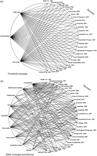
To visualize the connection between nodes in the coded text, a group query was conducted to create a connection map that showed linkages between different concepts and sources (Figure ). Similarly a framework matrix was created to determine the number of sources used as well as the total number of locations coded for different concepts and themes (Table ).
Figure 1 Linkages between research paper's coded text and nodes representing key themes and concepts.
The methods used in this study are aimed at identifying threshold concepts from seminal research papers for GIS. Threshold concepts framework is already utilized for course evaluation and design (Land et al., Citation2005) as well as for designing assessment for students' learning (Meyer & Land, Citation2010), and learning of these identified concepts can be easily targeted by engaging students in activities (Srivastava & Tait, Citation2012). Further research and empirical evidence are needed from instructors and students to examine the effectiveness of threshold concepts framework for students' GIS learning.
Threshold concepts in GIS
Selection of concepts and themes from existing GIS curricula while relating them to the characteristics of threshold concepts and subsequently performing summative content analysis of seminal research papers resulted in the identification of three threshold concepts: map-scale, data model and interoperability. This paper proposes these three concepts as the conceptual gateways that should be mastered before transforming a novice GIS user to a professional GIS expert, especially the first-time GIS learner. This framework is supported with the summative content analysis carried out on the coded text in 28 sources.
Map-scale
The term scale has multiple, and sometimes contradictory, meanings in different disciplines (Dungan et al., Citation2002; Goodchild, Citation2001; Mu & Wang, Citation2008). This study uses the term scale for the representative fraction, which is the ratio between the real world and the map representation, used by cartographers. Concepts such as cartographic ratio, grain, lag and resolution are considered to be synonyms of scale (Dungan et al., Citation2002).
The NCGIA core curriculum has emphasized map-scale in different units, thematic sections and volumes such as “Fundamental Concepts for GIScience”, “Handling Uncertainty” and “Abstraction and incompleteness” while linking the concept with other topics that include data model and data quality (NCGIA, Citation2000). Similarly, the GIS&T BoK emphasizes map-scale across various knowledge areas, units and topics. For example, the unit “Generalization and Aggregation” includes a topic “Scale and Generalization”, and a similar emphasis is given for map-scale in the knowledge areas “Conceptual Foundations”, “Geocomputation” and “Geospatial Data” (DiBiase et al., Citation2006). The summative content analysis of the selected seminal papers clearly shows the significance of the map-scale since this concept is featured in most of the sources (Table ). These sources also mention other GIS concepts indicating their linkage with map-scale (Figure ).
Scale is a fundamental concept in geography and working across multiple scales has been considered as a key strength of geographers (Atkinson & Tate, Citation2000; Harvey, Citation1968; Mu & Wang, Citation2008). Several theories have been proposed in different disciplines to emphasize the significance of scale. These include the scale theory in ecology, which proposes the linkage between patterns and scale in ecosystems as the central problem in ecology (Levin, Citation1992). Furthermore, there are biodiversity scaling rules common to all forms of life, including micro-organisms (Green & Bohannan, Citation2006). Similar emphasis has been given to the map-scale, also referred to as the geographical scale in the literature, in urban planning (Brenner, Citation2000), managing administrative units (Giordano, Citation2003), remote sensing (Quattrochi & Goodchild, Citation1997) and human geography (Brenner, Citation2001). Accordingly, scale is identified as a threshold concept in several disciplines, for example, biology (Ross et al., Citation2010) and nanoscience (Park, Light, & Mason, Citation2008).
In a GIS, as well as in cartography, the map-scale controls several key characteristics (Goodchild & Proctor, Citation1997; Goodchild, Citation2000). First, the level of generalization, as well as exaggeration, is controlled by map-scale. Second, map-scale controls the geometric form of an entity; for example, depending on the map-scale, a city is either shown by a polygon or by a point. Third, map-scale controls the smallest entity that can be shown on a map – as a general rule anything smaller than 0.5 mm cannot be perceptible on a map. Finally, the map-scale controls the positional accuracy and the level of uncertainty for an entity (Goodchild & Proctor, Citation1997).
Understanding the concept of map-scale is even more prudent in GIS because, within this system, one can seamlessly move from one map-scale to another map-scale (Atkinson & Tate, Citation2000; Golledge, Citation2002), thereby influencing all of the four above-mentioned characteristics of GIS data. Furthermore, scale of the final map plays a crucial role in integrating such a diverse data-set coming from multiple scales (Brewer & Buttenfield, Citation2010). The map-scale also influences the way real-world features are modelled to digital data-sets in the form of pixels, or by points, lines or polygons. Furthermore, the relationships among spatial entities are controlled by the map-scale which is well researched across disciplines (Benson, Citation2010; Levin, Citation1992). The following quote emphasizes how comprehending scale transformations enable better geographical thinking and reasoning:
New scale-dependent relationships are brought to view by spatially explicit reasoning. And finding scale-independent relations is the first step to developing robust geographic theory (Golledge, Citation2002, 7).
Understanding the concept of map-scale can be considered as the first portal through which a student must pass to develop their GIS learning. Only after understanding this concept, students will be able to recognize the significance of other key concepts such as:
| • | the generalization of real-world features to data models; | ||||
| • | errors and uncertainty; | ||||
| • | spatial autocorrelation; | ||||
| • | the analysis of geographical information, also referred as spatial analysis or geo-processing and | ||||
| • | the visualization of geographical information or geo-visualization. | ||||
These characteristics of map-scale show its integrative characteristics with other concepts such as data models and demonstrate how an understanding of map-scale is bounded with other concepts such as spatial autocorrelation and data quality (Table ). Initially, the learners are likely to find this concept troublesome, especially, to relate the effects of changing map-scale to data quality and analysis. A good understanding of map-scale has the potential to transform a GIS user by making them more cautious about inappropriate use of spatial data-sets across multiple scales (Table ).
Data model
“Data modelling” is not only identified as a separate knowledge area in the GIS&T BoK but also this is mentioned in other knowledge areas such as “Conceptual Foundation”, “Cartography and Visualization”, “Data Manipulation” and “Design Aspects” (DiBiase et al., Citation2006). The NCGIA core curriculum also emphasizes data model under units, thematic sections and volumes such as “Implementing Geographic Concepts in GISystems”, “What is Geographic Information Science”, “Information Organization and Data Structures”, “Representing Fields” and “Rasters” (NCGIA, Citation2000). While performing summative content analysis on selected published work, data model and similar concepts were coded in most of the sources at 288 different locations (Table ). While discussing data models, these sources relate data models with various other GIS concepts and themes (Figure ).
Representation of space and its subsequent implementation in a digital environment has been considered as the core of GIS (Leszczynski, Citation2009) as well as for all disciplines that study geographical information (Peuquet, Citation1988). Such representation is referred to as the data model (Peuquet, Citation1984). A data model is a general description of specific sets of entities, which are distinguishable real-world features, as well as the relationships between these sets of entities (Peuquet, Citation1984). A data model represents real-world geographical features as a digital spatial layer and stores associated attributes in a coordinate system. The two widely accepted approaches for conceptualizing and modelling geographical phenomena are field-based and object-based approaches (Cova & Goodchild, Citation2002).
In the field-based model, each location in space is mapped to a value selected from an attribute domain. For example, elevation, temperature and precipitation are widely used spatial variables, which are modelled using a field perspective. In the object-based model, space is perceived as a region populated with discrete entities, with each entity having a unique identifier and attribute values. River, road, land parcel and city locations are the classes of phenomena commonly modelled in the object perspective. Using these two approaches, all the geographical features can be modelled and this classification has been recognized as a valuable concept for geographical science research as well as teaching (Cova & Goodchild, Citation2002). Moreover, these conceptual data models are implemented specifically in software as data structures (Berry, Citation1987; Goodchild, Citation1987; Kemp, Citation1996a). The two commonly used data structures are raster; the cell-based system similar to a digital photograph with a constant dimension for each rectangular cell, and vector, which uses points, lines and polygons to represent real-world features (Berry, Citation1987).
These conceptual data model types, which are not considered mutually exclusive, have an implication on spatial analysis for real-world applications. The common object-based analysis functions include spatial query, point pattern analysis, distance calculation, overlay analysis, buffer generation, network analysis, cluster analysis, spatial similarity analysis, shape analysis and location modelling. The common operations on the field-based model include interpolation, classification, convolution, spatial overlay, statistical analysis, map algebra, spread functions, corridor analysis and terrain analysis. Several of these analyses can be carried out on either conceptual model. However, there are tools, which are considered more appropriate for one or the other conceptual model. For example, in a framework proposed for advanced map algebra, while selecting the conceptual data model, field-based model were preferred over the object-based model (Takeyama & Couclelis, Citation1997). Also importantly, the conceptual models have separate assumptions behind them, which in turn have implications for the spatial analysis and interpretation of subsequent outcomes. Although the two conceptual models can either be represented as vector or raster; the field-based model is mostly represented by raster, whereas the object-based model is mostly represented as a vector. These characteristics make the data model a key concept in GIS and its understanding has a strong potential to transform the GIS user (Table ).
A meaningful model to understand a real-world phenomenon can only be understood if the relationship between the real world (as it is represented by a data model) is understood and accounted for (Kemp, Citation1996b). Therefore, before proceeding to geo-visualization and geo-processing, one must be aware of the assumptions behind a data model and their appropriateness for that map-scale. Accordingly, data models are integrated with other key GIS concepts, including map-scale, errors and uncertainty, spatial autocorrelation, cartography and geo-visualization, metadata information, queries, overlaying and geo-processing (Table ).
From the early phase of the GIS, the capability to analyse spatial information has been considered as the main strength of GIS (Goodchild, Citation1987). While discussing general difficulties that are unique to handling spatial data, the following misuse of spatial analysis was predicted (Fotheringham & Rogerson, Citation1993):
…future users of GIS will recognize the limitations of spatial analysis, and will not misuse the spatial analytical methods that will inevitably be integrated within GIS. (Fotheringham & Rogerson, Citation1993, 3).
The word “limitations” in the above quote indicates the fundamental problem associated with geographical data (Fotheringham & Rogerson, Citation1993; Goodchild, Citation1992), which is well known to GIS users with a clear understanding of data models used within GIS. This clearly points towards the integrative and bounded characteristics of data models described in Table .
The data models of the future are still evolving and recently proposed data models will be multidimensional, as well as integrating object and field-based approaches (Goodchild, Yuan, & Cova, Citation2007). The future data models are going to include the third dimension, the z-axis representing altitude, as well as temporal components. These developments will greatly affect GIS and its technological component, the software. The constantly evolving nature of the data models within GIS makes it difficult to understand, and hence its learning can be defined as troublesome (Table ). Furthermore, the type of data model will control the spatial analysis in different discipline areas. Therefore, understanding the concept of the data model will provide another entrance portal that should be crossed before being truly capable of geographically analysing a real-world issue.
Interoperability
Interoperability has different levels of hierarchy and meanings; however, this paper emphasizes the GIS user's capability to apply GIS analysis in different disciplinary domains while integrating spatial tools with other analytical tools such as mathematical and statistical models. Accordingly, the GIS text mentioning about spatial analysis as well as GIS application and its integration with other disciplines was coded as interoperability.
Integration of knowledge from other disciplinary area into GIS and the subsequent application of GIS to other disciplinary area are emphasized in the GIS&T BoK across different knowledge areas, units and topics. For example, topics under the knowledge area “Analytical Methods” list set theory, Bayesian Methods, principles of spatial econometrics, data mining approaches and graph theory among others (DiBiase et al., Citation2006). While describing “Geographical Information Science” in the unit “What is GIS?” the NCGIA core curriculum lists disciplines that contribute to as well as benefited from GIS, and extending the list of disciplines that contribute knowledge into GIS is emphasized. Moreover, various other units such as “Multimedia and Virtual Reality”, “WebGIS” and “Artificial Neural Networks for Spatial Data Analysis” provide examples of bringing knowledge from other disciplines into GIS (NCGIA, Citation2000). One of the four volumes of NCGIS core curriculum is about application of GIS to other areas such as cadastral applications and precision agriculture (NCGIA, Citation2000). The summative content analysis of coded text in the sources selected for this study showed maximum number of locations, distributed in all the sources, coded for interoperability along with its linkage with other GIS concepts (Table ). While discussing other key concepts and themes, these papers also discussed incorporation of knowledge from other disciplinary area into GIS and the application of GIS to other disciplinary areas (Figure ).
One of the strengths of GIS is that it enables users to analyse and visualize geographical data according to their requirements by means of user-friendly tools available in several commercial GIS software packages that are used to apply GIS in various disciplinary domains. A vast range of spatial analysis and geo-visualization tools have been developed over the past half century and their requirement varies greatly depending on organizational and individual requirements (de Smith, Goodchild, & Longley, Citation2009). Numerous commercial and open source software tools are available to facilitate GIS analysis and visualization (de Smith et al., Citation2009).
Most of the GIS courses operating across the world are aimed at preparing students to carry out analysis, which can subsequently be interactively visualized on a variety of media. However, at the conceptual level, these tools use knowledge from other disciplines such as statistics (Burrough, Citation2001) and mathematics (Dale, Citation2005), and such analysis is mostly used for a variety of real-world problems belonging to various disciplinary domains. Therefore, to have a better conceptual understanding and to perform an advanced level of GIS analysis and geo-visualization, one should understand the concept of interoperability.
Through the 1970s and the early 1980s, most GIS applications, in relation to other digital systems, were considered islands of information (Bishr, Citation1998). However, this has changed tremendously in the twenty-first century, mainly because of the interoperability among different systems. GIS has already played a leading role to remove traditional isolation between the fields of photogrammetry, remote sensing, geodesy, cartography, surveying, geography, computer science, statistics and several other similar fields with interests in spatial data (Wright, Goodchild, & Proctor, Citation1997). Interoperability is defined to exist at six different hierarchical levels, and the sixth level in the hierarchy of interoperability enables seamless communication between different GIS without requiring a prior knowledge of semantics (Bishr, Citation1998) thereby enabling GIS application to different disciplinary fields. Most of today's GIS tools provide seamless interoperability at lower levels which includes network protocols, hardware and operating systems, spatial data files and data models. Working with GIS without understanding these key phenomena will be akin to using the tool with a black box approach, something which is undesirable for an expert GIS user.
Several multidisciplinary research and application projects now depend on the integrative and analytical power of GIS. In addition, advanced GIS analyses require programming, mathematical and statistical knowledge. Similarly, display of GIS data on the web for general audiences requires web-designing knowledge. These knowledge areas can be applied on GIS data only if they are interoperable or compatible with other systems. Initially, learning these relationships may appear troublesome to students (Table ). Understanding the concept of interoperability, which at the sixth level of the proposed hierarchy of interoperability (Bishr, Citation1998), is the mashing-up of data from different sources in a digital medium, can transform students' understanding and support them to utilize the integrative and analytical power of GIS. Therefore, understanding interoperability not only enable students to understand underlying concepts of data models but also will open new portals of learning by integrating GIS with other disciplinary knowledge for the subsequent GIS application. These characteristics of interoperability clearly demonstrate the integrative and transformative characteristics of the concept (Table ).
Relating the identified threshold concepts to the key GIS concepts
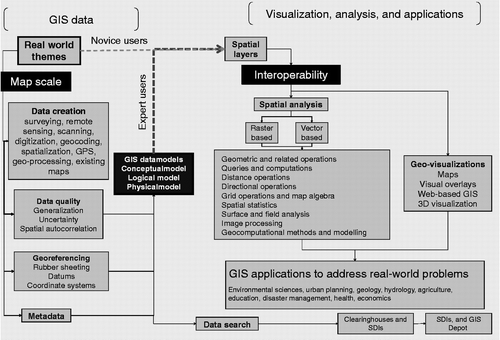
GIS learning relies considerably on understanding how the real-world features are transformed to spatial layers. However, the same layers, when used by expert GIS users are seen in a different way (Figure ). The expert use of GIS is more likely to consider the appropriateness of the data-set at the given map-scale, level of errors and uncertainty as well as spatial autocorrelation associated with the data-set (Figure ). Furthermore, expert GIS users must become familiar with the type of GIS data model used and the appropriateness of the coordinate systems and data for subsequent GIS analysis and applications, especially when data-sets are drawn from a variety of sources. When considering the advanced level of GIS application to a diverse set of disciplines, the expert GIS users must understand data interoperability and how the data-sets from diverse disciplines can be integrated with the existing GIS data-sets. A novice GIS user, who uses GIS as a tool, adopts a black box approach and may not be interested or even aware of the above-mentioned details. However, for an expert GIS user, all these key threshold concepts have to be grasped before they can address a real-world issue with GIS, and can become a GIS expert.
Figure 2 GIS threshold concepts, shown in black boxes and their linkages with other GIS key concepts.
The summative content analysis of coded text showed interrelatedness and boundedness of threshold concepts with one another as well as with other concepts and themes (Figure ). Moreover, the coded text within selected published papers was overly dominated by these concepts justifying their identification as the GIS threshold concepts (Table ).
Learner's transformation from novice to expert GIS user
With recent developments in GIS technology, both in software and hardware, the number of GIS users across a wide range of discipline has increased tremendously, and importance of spatial ability is recognized in earth science disciplines (King, Citation2006) that can only be achieved by mastering GIS threshold concepts. Identification of key threshold concepts of the emerging GIS discipline can help in classifying GIS users as expert and novice by establishing conceptual portals to be passed through, or concepts to be mastered, before becoming a GIS expert (Figure ).
Figure 3 Key threshold concepts and their boundedness with other key concepts in GIS.
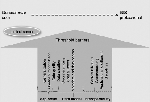
With the identification of troublesomeness associated with the understanding of concepts, the learners will be prepared for the difficulties to be faced, and the educators will be able to highlight the difficult part of the learning. By learning and understanding individual concepts, the users will be able to transform themselves for a better understanding of limitations associated with the technological components, and they will be able to communicate effectively using technical terms. Moreover, the discursive nature of threshold concepts enhances subject-specific language that, in turn, makes a learner an effective communicator by transforming them both ontologically and epistemologically, especially with disciplinary experts. For example, for a complete understanding of GIS threshold concept data models, the learners have to know about abstraction of the real world, coordinate systems and data. Similarly, for a complete understanding of map-scale, learners have to understand spatial dependence, errors and uncertainty, and generalization (Table ).
Conclusions
Transformative and integrative characteristics of the threshold concepts framework can provide a novel tool for affecting curriculum change (Entwistle, Citation2005) by engaging teachers in discussions about their understanding of their discipline and how it is taught (Meyer & Land, Citation2005). Accordingly, the threshold concepts framework has been considered as the jewel of curriculum design (Cousin, Citation2008). For the new and rapidly growing field of GIS, the identification of key threshold concepts and their integrative and transformative qualities is critical to support curriculum design and enhance students' learning. The identified threshold concepts will further offer a potential way of describing levels of understanding in GIS that could be used in assessment for learning. A similar approach can be adopted for other related disciplines, which include physical geography, human geography, surveying, remote sensing and even information science.
The developments in the arena of GIS curriculum development such as GIS&T Bok provide a judicious list of topics to be taught. The identification of key threshold concepts will further enhance the effectiveness of a GIS curriculum by identifying a proper sequence of topics to be covered and the likely difficulties that learners may encounter. Furthermore, the troublesomeness of selected topics, that is “stuck places” likely to be experienced by students, the interrelatedness among different key concepts and the topics to be mastered to become a GIS expert can be taken care of while using the integrative threshold concepts framework.
Since GIS is a fairly modern and emerging field with a rapidly increasing number of users, it is not surprising to note a proportion of users practising GIS with a superficial understanding. Therefore, it is even more important to identify the key threshold concepts of this discipline and utilize them to design course curricula, with more emphasis on well-designed assessment tasks, across universities (Srivastava, Citation2010). This is especially critical considering “crowd-sourced” spatial data is rapidly increasing (Goodchild & Glennon, Citation2010); and the online geospatial advances which go by names such as neogeography (Liu & Palen, Citation2010), volunteered geographical information (Goodchild, Citation2007), wikimapping and GIS 2.0 are rapidly expanding (Elwood, Citation2010).
Acknowledgements
The resources for completing this study were provided by University of the Sunshine Coast. The author is thankful to Prof JHF Meyer, Moira Cordiner and Michael Carey for providing useful comments on the manuscript. The author gratefully acknowledges three anonymous reviewers whose comments and suggestions on the earlier version of the manuscript improved the clarity of the paper.
Related Research Data
References
- Atkinson , P. M. and Tate , N. J. 2000 . Spatial scale problems and geostatistical solutions: A review . The Professional Geographer , 52 ( 4 ) : 607 – 623 .
- Baillie , C. , Bowden , J. and Meyer , J. F. 2013 . Threshold capabilities: threshold concepts and knowledge capability linked through variation theory . Higher Education , 65 ( 2 ) : 227 – 246 .
- Benson , M. H. 2010 . Regional initiatives: Scaling the climate response and responding to conceptions of scale . Annals of the Association of American Geographers , 100 ( 4 ) : 1025 – 1035 .
- Berry , J. K. 1987 . Fundamental operations in computer-assisted map analysis . International Journal of Geographical Information Science , 1 ( 2 ) : 119 – 136 .
- Bishr , Y. 1998 . Overcoming the semantic and other barriers to GIS interoperability . International Journal of Geographical Information Science , 12 ( 4 ) : 299 – 314 .
- Bradbeer , J. 1996 . Problem-based learning and fieldwork, a better method of preparation? . Journal of Geography in Higher Education , 20 ( 1 ) : 11 – 18 .
- Brenner , N. 2000 . The urban question as a scale question: Reflections on Henri Lefebvre, urban theory and the politics of scale . International Journal of Urban and Regional Research , 24 ( 2 ) : 361 – 378 .
- Brenner , N. 2001 . The limits to scale? Methodological reflections on scalar structuration . Progress in Human Geography , 25 ( 4 ) : 591 – 614 .
- Brewer , C. A. and Buttenfield , B. P. 2010 . Mastering map scale: Balancing workloads using display and geometry change in multi-scale mapping . Geoinformatica , 14 ( 2 ) : 221 – 239 .
- Burrough , P. A. 2001 . GIS and geostatistics: Essential partners for spatial analysis . Environmental and Ecological Statistics , 8 ( 4 ) : 361 – 377 .
- Cousin , G. 2006 . An introduction to threshold concepts . Planet Special Issue on Threshold Concepts and Troublesome Knowledge , 17 ( 12 ) : 4 – 5 .
- Cousin , G. 2008 . “ Threshold concepts: Old wine in new bottles or new forms of transactional curriculum inquiry ” . In Threshold concepts within the disciplines , Edited by: Land , R. , Meyer , J. and Smith , J. 261 – 272 . Rotterdam : Sense Publishers .
- Cousin , G. 2010 . Neither teacher-centred nor student-centred: Threshold concepts and research partnerships . Journal of Learning Development in Higher Education , Retrieved from http://www.aldinhe.ac.uk/ojs/index.php?journal = jldhe&page = article&op = view&path%5B%5D = 64&path%5B%5D = 41
- Cova , T. J. and Goodchild , M. F. 2002 . Extending geographical representation to include fields of spatial objects . International Journal of Geographical Information Science , 16 ( 6 ) : 509 – 532 .
- Dale , P. 2005 . Introduction to mathematical techniques used in GIS , Boca Raton : CRC Press .
- de Smith , M. J. , Goodchild , M. F. and Longley , P. A. 2009 . Geospatial analysis: A comprehensive guide to principles, techniques, and software tools , Leicester : Mathador .
- DiBiase , D. W. , DeMers , M. N. , Johnson , A. J. , Kemp , K. K. , Taylor-Luck , A. , Plewe , B. S. and Wentz , E. A. , eds. 2006 . Geographic information science and technology body of knoweldge , Washington, DC : Association of American Geographers .
- Dungan , J. L. , Perry , J. N. , Dale , M. R. T. , Legendre , P. , Citron-Pousty , S. , Fortin , M. J. , Jakomulska , A. , Miriti , M. and Rosenberg , M. S. 2002 . A balanced view of scale in spatial statistical analysis . Ecography , 25 ( 5 ) : 626 – 640 .
- Ellsworth , E. 1997 . Teaching positions: Difference, pedagogy, and the power of address , New York : Teachers College Press .
- Elwood , S. 2010 . Geographic information science: Emerging research on the societal implications of the geospatial web . Progress in Human Geography , 34 ( 3 ) : 349 – 357 .
- Entwistle , N. 2005 . Learning outcomes and ways of thinking across contrasting disciplines and settings in higher education . Curriculum Journal , 16 ( 1 ) : 67 – 82 .
- Fenneman , N. M. 1919 . The circumference of geography . Annals of the Association of American Geographers , 9 : 3 – 11 .
- Flanagan , M. 2012 . Threshold concepts: Undergraduate Teaching, Postgraduate Training and Professional Development A short introduction and bibliography , Retrieved from http://www.ee.ucl.ac.uk/∼mflanaga/thresholds.html
- Fotheringham , A. S. and Rogerson , P. A. 1993 . GIS and spatial analytical problems . International Journal of Geographical Information Science , 7 ( 1 ) : 3 – 19 .
- Fouberg , E. H. 2013 . ‘The world is no longer flat to me’: Student perceptions of threshold concepts in world regional geography . Journal of Geography in Higher Education , 37 ( 1 ) : 65 – 75 .
- Giordano , M. 2003 . The geography of the commons: The role of scale and space . Annals of the Association of American Geographers , 93 ( 2 ) : 365 – 375 .
- Golledge , R. G. 2002 . The nature of geographic knowledge . Annals of the Association of American Geographers , 92 ( 1 ) : 1 – 14 .
- Goodchild , M. F. 1987 . A spatial analytical perspective on geographical information systems . International Journal of Geographical Information Science , 1 ( 4 ) : 327 – 334 .
- Goodchild , M. F. 1992 . Geographical Information Science . International Journal of Geographical Information Systems , 6 ( 1 ) : 31 – 45 .
- Goodchild , M. F. 2000 . Communicating geographic information in a digital age . Annals of the Association of American Geographers , 90 ( 2 ) : 344 – 355 .
- Goodchild , M. F. 2001 . Metrics of scale in Remote Sensing and GIS . International Journal of Applied Earth Observation and Geoinformation , 3 ( 2 ) : 114 – 120 .
- Goodchild , M. F. 2004 . The validity and usefulness of laws in Geographic Information Science and Geography . Annals of the Association of American Geographers , 94 ( 2 ) : 300 – 303 .
- Goodchild , M. F. 2007 . Citizens as sensors: The world of volunteered geography . GeoJournal , 69 ( 4 ) : 211 – 221 .
- Goodchild , M. F. and Glennon , J. A. 2010 . Crowdsourcing geographic information for disaster response: A research frontier . International Journal of Digital Earth , 3 ( 3 ) : 231 – 241 .
- Goodchild , M. F. and Kemp , K. K. 1992 . NCGIA education activities – The core curriculum and beyond . International Journal of Geographical Information Systems , 6 ( 4 ) : 309 – 320 .
- Goodchild , M. and Proctor , J. 1997 . Scale in a digital geographic world . Geographical and environmental modelling , 1 : 5 – 24 .
- Goodchild , M. F. , Yuan , M. and Cova , T. J. 2007 . Towards a general theory of geographic representation in GIS . International Journal of Geographical Information Science , 21 ( 3 ) : 239 – 260 .
- Green , J. and Bohannan , B. J. M. 2006 . Spatial scaling of microbial biodiversity . Trends in Ecology & Evolution , 21 ( 9 ) : 501 – 507 .
- Harvey , D. W. 1968 . Pattern, process, and the scale problem in geographical research . Transactions of the Institute of British Geographers , 45 ( 1 ) : 71 – 78 .
- Hsieh , H. F. and Shannon , S. E. 2005 . Three approaches to qualitative content analysis . Qualitative Health Research , 15 ( 9 ) : 1277 – 1288 .
- Kemp , K. 1996a . Fields as a framework for integrating GIS and environmental process models. Part 1: Representing spatial continuity . Transactions in GIS , 1 ( 3 ) : 219 – 234 .
- Kemp , K. 1996b . Fields as a framework for integrating GIS and environmental process models. Part 2: Specifying field variables . Transactions in GIS , 1 ( 3 ) : 235 – 246 .
- Kemp , K. K. and Goodchild , M. F. 1992 . Evaluating a major innvoation in higher education – The NCGIA core curriculum in GIS . Journal of Geography in Higher Education , 16 ( 1 ) : 21 – 35 .
- King , H. 2006 . Understanding spatial literacy: Cognitive and curriculum perspectives . Planet: Special Issue on Threshold Concepts and Troublesome Knowledge , 17 : 26 – 28 .
- Land , R. , Cousin , G. , Meyer , J. H. F. and Davies , P. 2005 . “ Threshold concepts and troublesome knowledge (3): Implications for course design and evaluation ” . In Improving student learning–equality and diversity , Edited by: Rust , C. 53 – 64 . Oxford : OCSLD .
- Land , R. , Meyer , J. and Smith , J. , eds. 2008 . Threshold concepts within the disciplines , Rotterdam : Sense Publishers .
- Lee , J. and Bednarz , R. 2009 . Effect of GIS learning on spatial thinking . Journal of Geography in Higher Education , 33 ( 2 ) : 183 – 198 .
- Leszczynski , A. 2009 . Quantitative limits to qualitative engagements: GIS, its critics, and the philosophical divide . The Professional Geographer , 61 ( 3 ) : 350 – 365 .
- Levin , S. A. 1992 . The problem of pattern and scale in ecology . Ecology , 73 ( 6 ) : 1943 – 1967 .
- Liu , S. B. and Palen , L. 2010 . The new Cartographers: Crisis map mashups and the emergence of neogeographic practice . Cartography and Geographic Information Science , 37 ( 1 ) : 69 – 90 .
- Marsh , M. , Golledge , R. and Battersby , S. E. 2007 . Geospatial concept understanding and recognition in G6 College Students: A preliminary argument for minimal GIS . Annals of the Association of American Geographers , 97 ( 4 ) : 696 – 712 .
- Meyer , J. and Land , R. 2003 . “ Threshold concepts and troublesome knowledge: Linkages to ways of thinking and practising within the disciplines ” . In Enhancing teaching-learning environments in undergraduate courses project , 1 – 12 . Edinburgh : School of Education, University of Edinburgh . Occasional Report 4
- Meyer , J. and Land , R. 2006 . Threshold concepts and troublesome knowledge: Issues of liminality, Overcoming barriers to student understanding: Threshold concepts and troublesome knowledge , 19 – 32 . Abingdon : Routledge .
- Meyer , J. H. F. and Land , R. 2005 . Threshold concepts and troublesome knowledge (2): Epistemological considerations and a conceptual framework for teaching and learning . Higher Education , 49 ( 3 ) : 373 – 388 .
- Meyer , J. H. F. and Land , R. 2010 . “ Threshold concepts and troublesome knowledge (5): Dynamics of assessment ” . In Threshold concepts and transformational , Edited by: Meyer , J. H. F. , Land , R. and Baillie , C. 61 – 79 . London : Routledge .
- Mu , L. and Wang , F. 2008 . A scale-space clustering method: Mitigating the effect of scale in the analysis of zone-based data . Annals of the Association of American Geographers , 98 ( 1 ) : 85 – 101 .
- NCGIA (2000). The NCGIA Core Curriculum in GIScience. Retrieved from http://www.ncgia.ucsb.edu/giscc/cc_outline.html
- NRC . 2010 . Strategic directions for the Geographical Sciences , Washington, DC : The National Academies Press .
- Park , E. J. , Light , G. and Mason , T. 2008 . “ Identifying threshold concepts in learning Nanoscience by using concept maps and students' responses to an open-ended interview ” . In Eighth International Conference on Learning Sciences , 109 – 110 . Utrecht : International Society of the Learning Sciences .
- Pattison , W. D. 1964 . The four traditions of Geography . Journal of Geography , 63 ( 5 ) : 211 – 216 .
- Perkins , D. 1999 . The many faces of constructivism . Educational Leadership , 57 ( 3 ) : 6 – 11 .
- Peuquet , D. 1984 . A conceptual framework and comparison of spatial data models . Cartographica: The International Journal for Geographic Information and Geovisualization , 21 ( 4 ) : 66 – 113 .
- Peuquet , D. 1988 . Representations of geographic space: Toward a conceptual synthesis . Annals of the Association of American Geographers , 78 ( 3 ) : 375 – 394 .
- QSR (2012). NVivo 9. Retrieved from http://www.qsrinternational.com
- Quattrochi , D. A. and Goodchild , M. F. 1997 . Scale in remote sensing and GIS , Boca Raton : Lewis Publishers .
- Ross , P. , Taylor , C. , Hughes , C. , Whitaker , N. , Lutze-Mann , L. , Kofod , M. and Tzioumis , V. 2010 . Threshold concepts in learning Biology and Evolution . Biology International , 47 : 47 – 54 .
- Srivastava , S. K. 2010 . “ An assessment regime for geographical information systems to promote deep-learning approach among multidisciplinary students ” . In ATN Assessment Conference 2010: Assessment: Sustainability, Diversity and Innovation , 76 – 87 . Sydney : University of Technology .
- Srivastava , S. K. and Tait , C. 2012 . An activity-based learning approach for key geographical information systems (GIS) concepts . Journal of Geography in Higher Education , 36 ( 4 ) : 527 – 545 .
- Takeyama , M. and Couclelis , H. 1997 . Map dynamics: Integrating cellular automata and GIS through Geo-Algebra . International Journal of Geographical Information Science , 11 ( 1 ) : 73 – 91 .
- Unwin , D. J. 1997 . Curriculum Design for GIS . NCGIA Core Curriculum in GIScience , Retrieved from http://www.ncgia.ucsb.edu/giscc/units/u159/u159.html
- Wright , D. J. , Goodchild , M. F. and Proctor , J. D. 1997 . Demystifying the persistent ambiguity of GIS as “Tool” versus “Science” . Annals of the Association of American Geographers , 87 ( 2 ) : 346 – 362 .