
Abstract
Stratigraphic investigations, supported by palynological dating, detrital zircon and monazite dating, and quartz grain micromorphology were undertaken of the Early Cretaceous strata around the southern margin of the Eromanga Basin where they onlap older rocks of the northern Flinders Ranges. The presence of a tillite within the Early Cretaceous Cadna-owie Formation and another in the Trinity Well Sandstone are evidence of two significant glaciations: the oldest, the Livingston Tillite Member, is from the middle Valanginian; the younger, the Sheehan Tillite Member, is from the early Aptian. A significant hiatus encompassing the Barremian interrupts the succession. Extensive dropstones, minor diamictite lenses and beds and a bed containing glendonite crystals, together indicate that cold (limited glacial and/or seasonal freezing) conditions persisted through the Hauterivian and the Aptian, with cold conditions peaking in the late Aptian.
Introduction
Many early geologists working around the southern margin of the Eromanga Basin () noted the presence of large exotic clasts either lying on or within the Mesozoic succession or on exposed bedrock beyond basin margins. These were variously interpreted to be due to Cretaceous glaciation (Brown, Citation1894; David, Citation1906; Jack, Citation1915; Woolnough, Citation1926; Woolnough & David, Citation1926), reworking from older glacial rocks (from the Neoproterozoic Sturtian or Permian sediments; David & Howchin, Citation1923; Howchin, Citation1928; Parkin, Citation1956) or, because of the apparent lack of glacial characteristics, interpreted to be fluvial in origin (Woodard, Citation1955).
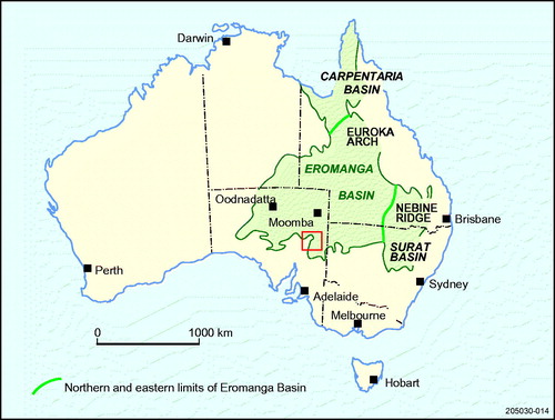
Figure 1. Outline of the Eromanga Basin and associated Mesozoic basins. The red square approximately marks the area under consideration of northern Flinders Ranges and adjacent lowlands. Modified from Alexander and Cotton (Citation2006).
The presence of dropstones and lonestones in the Early Cretaceous succession led a number of workers to conclude that the clasts were rafted by seasonal river ice out into the Eromanga Basin, thus inferring that climate was cold enough for seasonal freezing (Frakes & Francis, Citation1988, Citation1990; Frakes & Krassay, Citation1992; Frakes, Alley, & Deynoux, Citation1995). Glendonite crystals, present in the Aptian part of the succession, were regarded as evidence of near-freezing sea water during that time (de Lurio & Frakes, Citation1999; Sheard, Citation1991).
On the basis of a tillite (Livingston Tillite Member) in the Early Cretaceous Cadna-owie Formation, Alley and Frakes (Citation2003) recognised the first evidence for Cretaceous glacial ice on the northwestern margin of the Flinders Ranges. Subsequently Alley, Frakes, Sheard and Gray (Citation2011) proposed, on a preliminary basis, that there may be as many as three glacial events within the Early Cretaceous around the northern margins of the Flinders Ranges.
Much has been written about cold intervals during the Early Cretaceous and the potential for freezing and the formation of glacial ice at high latitudes (see below), but the Livingston Tillite Member of Berriasian–Valanginian age (Alley & Frakes, Citation2003) presently remains the only physical evidence of Early Cretaceous glacial ice. Hay (Citation2008) regarded the Livingston Tillite Member as the only unequivocal geological evidence of ice, Gröcke et al. (Citation2005) noted that the tillite provided the first direct evidence of a Cretaceous glaciation and Grasby, McCune, Beauchamp and Galloway (Citation2017) noted that the tillite is still the only physical evidence of glacial ice in the Early Cretaceous.
Since the work of Alley and Frakes (Citation2003) and Alley et al. (Citation2011) we have undertaken extensive research on the stratigraphy of the Early Cretaceous onlap succession at key sites of outcrop and drill holes within and around the margins of the Flinders Ranges and in the deeper parts of the Eromanga Basin. We have endeavoured to put the lithostratigraphy, including glacial facies, into a well-constrained chronostratigraphic framework in which we relied heavily on palynological dating and, at some sites, detrital zircon and monazite dating.
In this paper, we outline:
methodologies employed;
the broader geological setting for the glaciations;
stratigraphic setting for the glacial sediments;
the glacial events in the southern Eromanga Basin; and
a correlation with global cold climate intervals during the Early Cretaceous.
Field and laboratory methods
We rely heavily upon palynological dating in constructing a chronostratigraphy of the Early Cretaceous sediments in the area and in correlation between widely spaced sites and boreholes, thus extensive sampling of suitable horizons was undertaken. This dating is supported by detrital zircon dating of some facies sampled. Quartz grain micromorphology was also a useful adjunct to our interpretation of glacigene lithofacies in the field.
Field investigations
Lithologs were constructed for all sites visited and drill holes inspected. Detailed records of grainsize, bedding characteristics, clast shapes, paleontological remains (faunal and floral) and ichno-fabric were made. The overall stratigraphy of the succession at sites was traced laterally to its full extent, taking note of significant and local unconformities. For the GPS locational data, we used GDA94 datum.
Palynostratigraphy
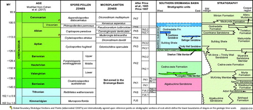
We use the palynological zonation schemes of Helby, Morgan and Partridge (Citation1987), Price (Citation1997), Price, Filatoff, Williams, Pickering and Wood (Citation1985), and modifications by Alley, White, Price and Wood, (Citation2006) in dating the Early Cretaceous sediments (). The value of palynological dating is that it can be applied to both marine and non-marine sediments and in boreholes where typically a fairly detailed continuous record can be determined. The limitations and advantages of palynological dating and its application to the Early Cretaceous succession in the Eromanga Basin are discussed by Alley and White (Citation1996) and Alley et al. (Citation2006).
Figure 2. Chronostratigraphy of the broader Eromanga Basin showing the palynological zones (spore-pollen and microplankton after Helby et al., Citation1987; modifications after Alley et al., Citation2006) used in dating the succession. Where Coorikiana Sandstone is not present, the Aptian–Albian shale succession is referred to as Marree Subgroup.
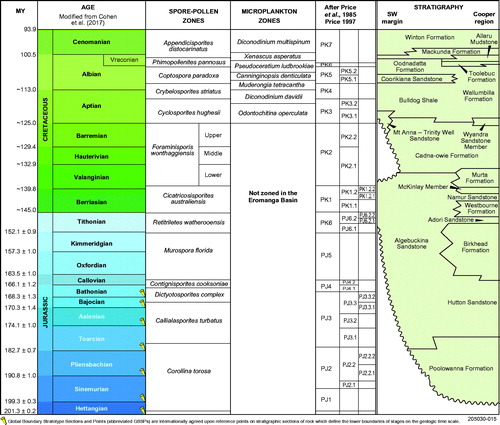
We have calibrated the palynological zones against the time-scale of the International Commission on Stratigraphy chart 2017 (updated by Cohen, Finney, Gibbard, & Fan, Citation2017). This time-scale uses a numerical scale with a clearly defined error for each boundary, or where that is not possible, shows that the timing of a boundary is approximate and liable to change. Some boundaries, where agreed as a fixed time, are shown as a golden spike. Numerical ages were provided by the International Commission on Stratigraphy for the Cretaceous Period.
Sampling
Up to 1 kg samples were taken at field sites where the facies allowed, including carbonaceous sediments, fine-grained, unweathered sediments and fine-grained calcareous concretions within the sediments. Exposures were dug and cleaned so as to expose uncontaminated sediment. Sampling was undertaken with a cleaned spade and the samples sealed in labelled plastic sample bags.
Key stratigraphic drill holes were logged, and small samples taken and sealed in plastic sample bags. Core was sampled in preference to cuttings, but in some cases only cuttings were available for some intervals.
Laboratory processing
Processing of some samples was undertaken by the Geological Survey of South Australia (Department for Energy and Mining) laboratory in Adelaide following a procedure outlined by Broadbridge (Citation1994):
gentle crushing and boiling of samples (30–50 g in weight) in HCl, washing followed by adding Brij 35 and a brief ultrason, then concentrated HF and heavy liquid separation;
the organic matter remaining is then oxidised using Schulze Solution, followed by further heavy liquid separation to remove vitrinite and any light mineral matter remaining;
further oxidation employing potassium carbonate followed by sieving to remove larger particles of organic matter; and
the final residue containing palynomorphs is mounted in glycerine jelly on microscope slides.
Other samples were processed by MGPALAEO Geological and Stratigraphic Consultants Pty Ltd, Perth:
samples were crushed and washed using either a detergent or a solvent;
digestion in 32% HCl until any reactions ceased;
samples were then digested in 49% HF for a period of 8–12 h to remove any remaining mineral matter;
samples were processed using standard palynological techniques and sieved between 10 and 100 μm, with kerogen slides being prepared before the oxidation phase that involved the use of high concentration nitric acid for varying amounts of time depending on the condition of the samples; and
samples were then mounted in glycerol and dried.
Microscopy
Microscope slides were extensively scanned on Zeiss Photomicroscopes to identify key zonal and associated species. Frequency studies (counting and identifying 300–500 palynomorphs) of some samples were carried out to help understand the structure of the palynofloras to aid in determining the spore/pollen or microplankton zone.
The location of key palynomorphs that contributed to the definition of a zone and mentioned in the text were noted. Photography was undertaken using a Nikon DS-Ril camera attached to a Dell Precision T3500 computer. Key taxa were photographed and their locations on the microscope slides, using the coordinates on the Zeiss Photomicroscope, and the magnification were recorded.
Detrital zircon and monazite dating
Since the early studies that utilised U–Pb dating of detrital zircon in sedimentary provenance studies, the main goal has been to identify different age populations in sedimentary rocks and to link them to particular geological events or to potential source areas. The relatively recent use of laser ablation (LA) ICP-MS of zircon from sedimentary provenances has allowed for large quantities of data to be obtained per sample (Sláma & Košler, Citation2012).
The laser ablation-inductively coupled plasma mass spectrometry (LA-ICPMS) U–Pb zircon and monazite geochronology data were derived from fourteen samples collected from Cretaceous sediments, diamictite and tillite from outcrop and drill holes. Analyses were made on a 213 nm New Wave Research laser ablation unit coupled with an Agilent 7700 quadrupole ICPMS housed at Adelaide Microscopy, the University of Adelaide (Payne, Barovich, & Hand, Citation2006; Reid, Payne, & Wade, Citation2006).
For zircon analysis, the laser unit was run using a 26 μm spot size and a 5 Hz repetition rate. Analytical spot size was 26 μm. Time-resolved signals of 204Pb, 206Pb, 207Pb, 208Pb, 232Th and 238U were acquired during a 60 s analytical interval, comprising 30 s of background signal, before the onset of laser ablation and the subsequent collection of 30 s worth of analytical signal related to the sample being analysed.
For monazite analysis, the laser unit was run using a 12 μm spot size and a 5 Hz repetition rate. Analytical spot size was 12 μm. Time-resolved signals of 204Pb, 206Pb, 207Pb, 208Pb, 232Th and 238U were acquired during a 60 s analytical interval, comprising 30 s of background signal, before the onset of laser ablation and the subsequent collection of 30 s worth of analytical signal related to the sample being analysed.
Where youngest detrital zircon ages have relevance to constraining stratigraphic ages, the age is depicted for the lithology at the appropriate stratigraphic horizon on the lithologs.
Quartz grain micromorphology
During the course of the detrital zircon dating we retained the remaining mineral grains and subjected them to microscopy using a Nikon Eclipse E600 POL microscope and a scanning electron microscope Quanta 600 SEM. Because the sediments are generally not strongly lithified and, in some cases unconsolidated, the processing for detrital zircons and monazites is unlikely to have caused further fracturing of the grains in the laboratory, or if any, laboratory induced fracturing would be very minor.
We initially examined the surface textures of quartz grains of all diameters, but then concentrated on the >200 µm fraction since the size of the grains provided a greater range of features.
Following the procedure of Mahaney (Citation2002) and Mahaney, Claridge and Campbell (Citation1996) at least 25 grains of the >200 µm fraction from each sample were photographed and analysed, although in the general, many more grains from each sample were inspected. We also examined the textures on other mineral grains, especially garnet, which in places preserved glacigene features such as micro-striae.
Geological setting
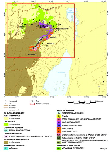
The Early Cretaceous strata onlap basement rocks of the northern Flinders Ranges, which are the Mt Painter and Mt Babbage inliers, consisting of deformed ?Paleoproterozoic to Mesoproterozoic metasediments and Mesoproterozoic granitic and volcanic rocks (). The inliers were intruded by granitic rocks post the Delamerian Orogeny (Elburg, Bons, Foden, & Brugger, Citation2003; Teale, Citation1979). Adjacent lowlands are underlain by Cambrian–Ordovician, Carboniferous–Permian, Mesozoic and Cenozoic sediments.
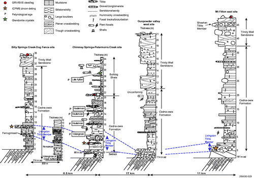
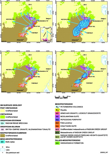
Figure 3. General geology map (2-mile scale) of the northern Flinders Ranges and adjacent lowlands. Modified from SARIG, February 2018. The names of the key outcrop sites (numbers) and drill holes (letters) are given in .
The Mesozoic and Cenozoic sediments of the Eromanga Basin and Lake Eyre Basin, respectively onlap the crystalline and Adelaidean rocks of the ranges and can form outliers within the ranges. Generally, the Mesozoic succession dips gently (2–5°) basinward (northward), although locally significant faulting, folding and even overturning can be observed. A major thrust fault, varying from 5–15 km out from the northern margin of the ranges has disrupted the succession leading to major stripping of the Aptian–Albian units, in particular the Marree Subgroup, and the Cenozoic sediments ().
Up to 3000 m of Eromanga Basin sediments were deposited in a broad continental downwarp that extended across much of inland east-central Australia during the Jurassic and Early to mid-Cretaceous, in places in fluvial to fluvio-lacustrine conditions and at other times in a shallow epicontinental sea that experienced a number of eustatic changes in sea level. The lithostratigraphy of the regional Early to mid-Cretaceous units is covered well by Alexander, Sansome and Cotton (Citation2006), and Krieg, Alexander and Rogers (Citation1995) and locally, by Sheard (Citation2009).
During the Early Cretaceous, the Australian plate was at very high latitudes and still attached to the Antarctic plate, thus the southern Eromanga Basin lay between 70 and 80° S for much of the time ().
Figure 4. Position of the Australian plate during Late Jurassic to Cenomanian. Red square marks approximate position of study area. (a) 160 Ma, Late Jurassic; (b) 132.5 Ma, Early Cretaceous (Valanginian); (c) 118 Ma, Early Cretaceous (Aptian); and (d) 96 Ma, Late Cretaceous (Cenomanian). Modified from Alexander et al. (Citation2006) who used Veevers, Powell and Roots (Citation1991) and Baillie, Powell, Li and Ryan (Citation1994) as a source.
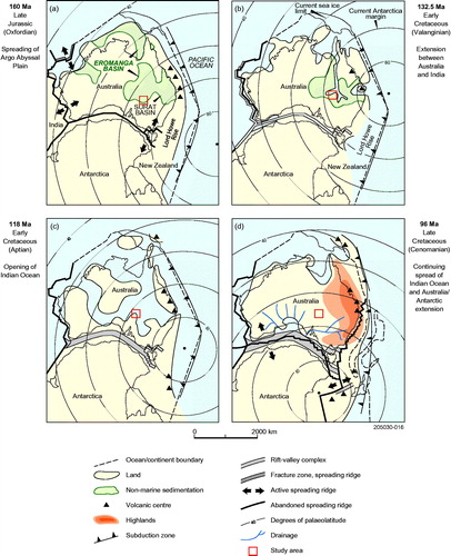
The position of the Australian plate from Valanginian to Aptian times shows that the southern Eromanga Basin was well south of the current northern limit of the Antarctic continent and well south of the current limit of sea ice at high southern latitudes. This means that daylight would have been minimal for a significant part of the year and that freezing conditions may have been possible during this interval.
Stratigraphic setting of the glacial units
Model and terminology for deposition of key units
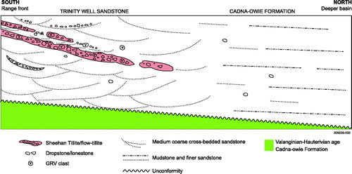
We interpret the Livingston Tillite and Sheehan Tillite members to have been deposited by fairly short and relatively thin glaciers. Much of these glacigene sediments that crop out around the margins of the ranges was probably deposited by glaciers terminating in a shallow sea and/or lake. Hence, a complex of facies was laid down directly by ice (as lodgement or basal till) or by debris shed from melting ice into glacio-marine to glacio-lacustrine conditions including by melting of icebergs (the proglacial environment) ().
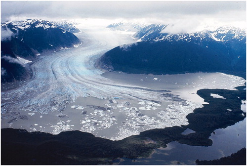
Figure 5. Terminus of the Great Glacier, northwestern British Columbia, Canada. Piedmont glacier, with valley glacier section up valley, terminating in a lake. Large icebergs, the larger measuring 200–300 m long, are calving from the glacier terminus. Dark areas on glacier and icebergs are suprglacial moraine. Dark streaks in upper right part of the lake are sediment plumes. Forested Neoglacial terminal moraine with lakes between the morainal ridges. Scale of lake in which glacier terminates is 6.7 km across, the piedmont ice spread 4 km across and valley glacier up valley is 1.3 km across. On a smaller scale this is the potential model for glaciers depositing the Livingston Tillite and Sheehan Tillite members. Photo taken 1977.
We use the term ‘tillite’ where there is certainty of glacial deposition including the presence of striated, polished and facetted pebbles and boulders set in clay to sand matrix. This interpretation is supported by the micromorphology of quartz grains characteristic of a glacial environment. In a few instances where analysis of clast fabric was undertaken, a well-developed dominant orientation typical of a basal (lodgement) till was determined. We use the term ‘diamictite’ where we could find no evidence of deposition by glacial ice.
In the proglacial setting, thin supraglacial moraine and other debris commonly slides from the glacier and iceberg surfaces into the adjacent ice marginal water-filled basin and may form lenses of flowtill within fluvioglacial, glacio-lacustrine or glacio-marine deposits (Evenson, Dreimanis, & Newsome, Citation1977; Hicock, Dreimanis, & Broster, Citation1981), although other authors refer to such subaquatic debris flows as ice-marginal debris-flow deposits (de Jong & Rappol, Citation1983), subaquatic glacigenic debris flows (Broster & Hicock, Citation1985) or supraglacial diamicts (Eyles & Eyles, Citation1992) (). The flowtills are generally coarser in matrix texture (up to sand size), exhibit a poorly developed fabric, which if present may be oriented in the direction of mass flow. Clasts tend to be more angular, are interbedded with cross- to planar-bedded clastics containing dropstones and conglomerate lenses. Significantly these units are underlain by an erosional disconformity (Evenson et al., Citation1977; de Jong et al., 1983; Larson, Menzies, Lawson, Evenson, & Hopkins, Citation2016).
Figure 6. Formation of flowtills in a proglacial ice-contact setting.
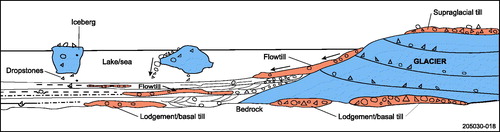
The lenticular and in places poddy nature of the tillite facies in association with other bedded clastics in the Livingston Tillite and Sheehan Tillite members is probably the result of deposition in the ice marginal (proglacial) setting described above.
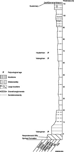
Cadna-owie Formation
The exposed Cadna-owie Formation is a bioturbated, commonly carbonaceous, cross-bedded and level bedded fine to medium sandstone, with minor coarse sandstone intervals, that directly overlies fresh or weathered bedrock. The lower part of the formation incorporates extensive bouldery facies, conglomerate, lonestones, dropstones, tillite and tillite lenses (), all of which we now include in the Livingston Tillite Member of Alley and Frakes (Citation2003; see below). The member is near the base of Cadna-owie Formation in Yalkalpo 1 drill hole some distance from the ranges. The upper part of the formation around the margins of the ranges is marked by an unconformity of regional extent with the overlying Trinity Well Sandstone representing a hiatus encompassing the Barremian. The Cadna-owie Formation was deposited in very shallow marine to non-marine conditions, with hummocky cross-stratification at some levels indicating deposition above storm wave base.
Figure 7. Diagrammatic representation of the stratigraphic setting of the Livingston Tillite Member and the distribution of ice-rafted debris in the Cadna-owie Formation.
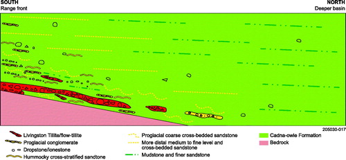
The age of the Cadna-owie Formation ranges from Valanginian to early Aptian, with a hiatus recognised that encompasses the Barremian (). The Livingston Tillite Member is Valanginian in age, although tillitic lenses and dropstones appear to linger into and throughout the Hauterivian section.
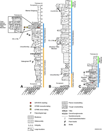
Figure 8. Stratigraphy of the southern Eromanga Basin. Age ranges of the stratigraphic units in the southern Eromanga Basin are based on palynological dating from key drill holes and outcrop. Stratigraphy of the greater Eromanga Basin within South Australia presented in right-hand column.
Type section of the Livingston Tillite Member at Recorder Hill–Trinity Well site
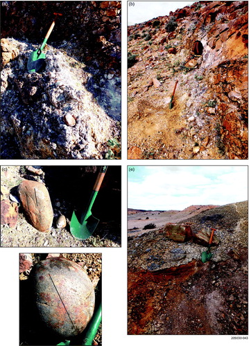
The type section is at the ‘Recorder Hill’ (informal name) section designated by Alley and Frakes (Citation2003), location centred on 335539E 6697023N. We have included in the definition of the member all the sediment below the tillite to weathered bedrock and all that above to and including a large lens of flowtillite (∼8 m level, and ).
Figure 9. Litholog for the Livingston Tillite Member at the type section. Enlargement on right of figure shows the facies now included in the member.
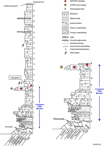
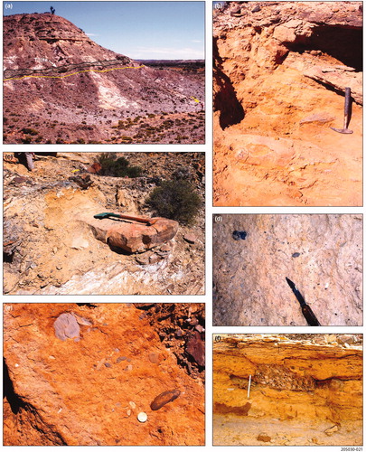
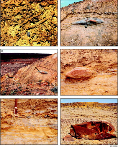
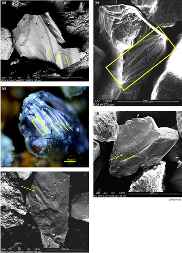
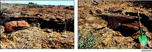
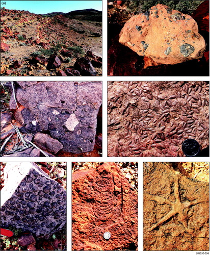
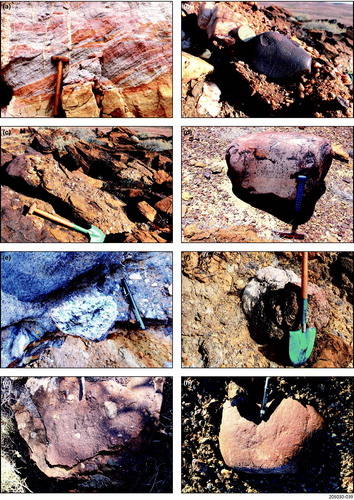
Figure 10. Livingston Tillite Member at ‘Recorder Hill’ type section. (a) Recorder Hill showing the unconformity between the Cadna-owie Formation and bedrock (yellow line) and the position of the Livingston Tillite Member tillite facies (shaded grey area between the black lines). Person in lower right arrowed. (b) Cross-bedded, bouldery sandstone underlying the tillite facies, the more lithified sediment above geological pick handle. Boulder of granite to left of pick and large quartzite boulder lower left from pick. Note the sloping disconformity between the tillite facies and underlying sandstone, which becomes an interfingering relationship upslope. (c) Large subrounded pink sandstone boulder at base of the Cadna-owie Formation overlying weathered bedrock. (d) Tillite facies with finer-grained matrix. Small clasts dominated by siltstone from the local bedrock, in this area an unnamed unit of the Billy Springs Formation. Blade of knife 6.5 cm in length. (e) Boulders and pebbles in sandier facies of the tillite dominated by local siltstone (grey clasts) and rounded quartzite pebble, upper right from two-dollar coin. (f) Section through sandier tillite exposing a boulder of Pepegoona Porphyry. Magnetic pen ∼15 cm length. (g) Strongly bioturbated upper surface of the sandy tillite facies. Ten cent coin for scale. (h) Calcareous tillite lens within mudstone at the 7–8 m level. Large pink sandstone clast to right of spade. Between spade and clast is a thin lens of HCS sandstone. (i) Photo showing stratigraphic position of the tillite lens (black arrow) and the tillite facies (yellow arrow). (j, k) are consecutive views of the same bed from left to right. (j) Dropstone of quartzite within the Cadna-owie Formation at approximately the 10–11 m level. Note how the boulder penetrates the sediments, typical of dropstones. A thin layer of gravel and clay rip-up clasts extends to the right of the boulder. Pen measures 13.5 cm in length. (k) A thin layer of gravel and rip-up clasts to right of boulder. HCS sandstone within and below the layer. (l) Westerly looking view of very large lonestone of quartzite (spade for scale) derived from the Cadna-owie Formation. Lower part of the Trinity Well Sandstone and the transition from the underlying Cadna-owie Formation exposed in the east-facing escarpment in the middle distance. Upper part of the Trinity Well Sandstone exposed in a west-facing escarpment along the ridge top in the distance.
The lower metre or so is a fairly massive, pebbly, bouldery and even conglomeratic in part, medium and coarse sandstone. A thin layer of pebbles and boulders lies along the contact with the bedrock. The massive sandstone is overlain by level-bedded and cross-bedded medium and coarse sandstone containing thin conglomerate, large isolated boulders, thin mudstone and in places thin tillite lenses. Hummocky cross-stratification (HCS) occurs at about the 1.5 m level.
The tillite facies is about a metre thick at the line of section but varies laterally up to several metres thick. It is a massive, carbonate cemented to lithified tillite, with a sandy to silty-clay matrix and contains abundant pebbles and large boulders. Clast shape varies from angular to rounded, in places polished, facetted and striated. The tillite extends along the complete lower slope of the Recorder Hill site and up to 3 km to the north at a number of outcrops. The tillite facies is strongly bioturbated on its upper surface and to a lesser extent within the tillite itself. This along with the HCS above and below the tillite indicates deposition in shallow marine conditions, certainly within storm wave influence.
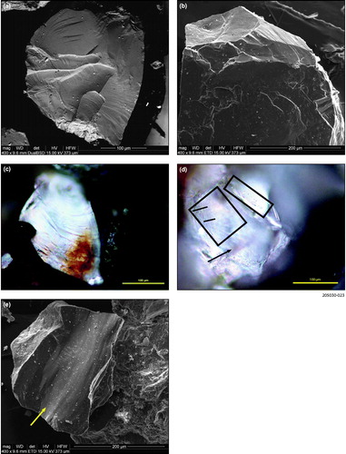
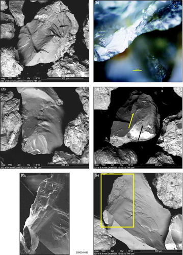
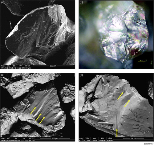
We undertook a micromorphological examination of the quartz grains, which showed strong angularity, numerous angular conchoidally fractured grains, along with striae, chattermarks and grooves indicative of glacial transport (), thus supporting the conclusions of Alley and Frakes (Citation2003).
Figure 11. Quartz grain micromorphology, Livingston Tillite Member at the type section. (a) Sharp edged grain exhibiting multiple conchoidal fractures. Type section at Recorder Hill site. (b) Subangular grain with conchoidal fractures and slightly lifted plates. (c) Conchoidal fracture on sharp edged grain. (d) Grain exhibiting chatter mark (in upper right rectangle) and striae (orientation shown on left rectangle by lines), groove shown by arrow. (e) Grooving and striae along a smoothed surface, with orientation shown by arrow.
While the lithology of the clasts shows they are dominantly derived from the local bedrock, low frequencies of granite (including Mt Neill Granite), Pepegoona Porphyry, volcanic and metamorphic rocks are present. Rare clasts of saccharoidal pink granite with a possible source near Parabarana Hill and the Mount Gee area occur in the Mount Painter Inlier; highly strained gneiss and unusual blue quartz indicative of Mt Neill Granite source are also present. These clasts demonstrate long distance transport, in particular the Pepegoona Porphyry and Mt Neill Granite. The nearest outcrop of the porphyry is some 32 km to the southeast in the Mt Painter Inlier.
At the 7–8 m level is a significant lens of calcareous tillite in a zone of bouldery mudstone containing some HCS, including within the lens itself. The bioturbated sandy mudstone below contains polished and facetted pebbles, abundant plant matter and minor low amplitude HCS. The lens was possibly ice-rafted and dropped into shallow water or was a flowtill emanating from nearby stagnating glacial ice. In view of the glacial characteristics of clasts in the lens we extend the thickness of the type section of the Livingston Tillite Member as defined by Alley and Frakes (Citation2003) up to and including the lens at ∼8 m level.
At the type section, we interpret the environment to have changed during deposition of these facies from at first proximal proglacial, to glacial (the tillite), then proximal proglacial and finally more distal glacio-marine.
An age of Berriasian to Valanginian was obtained by palynological dating (Alley & Frakes, Citation2003; Alley & Lemon, Citation1988) of carbonaceous mudstone just above the flow tillite lens. We reprocessed the remaining bulk sample using current processing techniques and obtained more diverse and better preserved palynofloras of Valanginian age. Samples of Cadna-owie Formation from Petromin 169121 610 8 drill hole some 7 km west of Recorder Hill and in a similar stratigraphic setting were taken for palynological dating (). The ages obtained show the lower part of the Cadna-owie Formation is Valanginian in age and the upper part extends into the Hauterivian. Thus, in the area of the type section, the age of the Livingston Tillite Member is Valanginian, but the upper part of the Cadna-owie Formation extends into the Hauterivian, a similar range in age we obtained from outcrop and drill-hole samples elsewhere.
Figure 12. Litholog for Petromin 169121 610 8 drill hole located some 7 km west of Recorder Hill. Log based on our observations and driller’s log (Petromin, Citation1971a, Citation1971b).
Livingston Tillite Member facies variations at other sites
Pelican Well
Around the northwestern margins of the ranges at the Pelican Well site () a discrete tillite facies is not present. Here the glacigene sediments are sandy and silty, bioturbated, level-bedded and partly cross-bedded mudstone and fine sandstone, containing significant boulder, gravel and tillite lenses and layers, isolated boulders and dropstones and carbonaceous matter along some bedding planes (). A number of the larger clasts exhibit glacial characteristics including polishing, facetting and striae, as well as shapes varying from rounded to angular. These features, along with evidence that they penetrate the underlying sediments and are associated with tillites, strongly suggest they have been dropped from floating ice, an interpretation supported by the quartz grain micromorphology. Many quartz grains exhibit multiple conchoidal fractures, some display sharp edges, a few with rounded edges, some grains exhibit grooves and striae, while a few have been rounded after fracturing, indicative of glacial transport (). The sample was taken from a tillite lens within cross-bedded sandstone, thus we interpret the lens to be part of a flowtill deposited in a proximal ice-contact setting, thus explaining the rounding of some grains after fracturing.
Figure 13. Lithologs for Pelican Well and Village Well sites, showing the stratigraphic position of the Livingston Tillite Member.
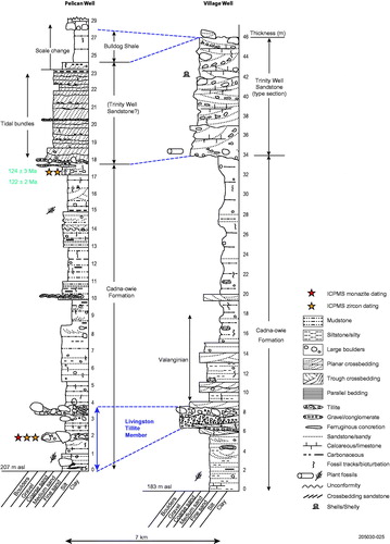
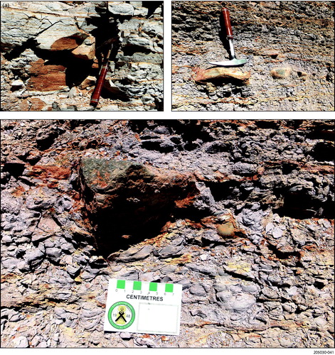
Figure 14. Livingston Tillite Member and glacigene facies at other sites. (a) Bouldery, pebbly and tillitic facies within the basal Cadna-owie Formation at Pelican Well site. Spade 75 cm length. (b) Large polished and faceted quartzite boulder exhibiting striae, the orientations of which are shown by the yellow lines and penetrating the underlying sediment. Pelican Well site. (c) Poddy tillite with undulating to irregular base (just above pen) penetrating mudstone below. Pen 15 cm in length. (d) Polished, rounded and facetted quartzite boulder displaying striae, the orientation of which is shown by the black line. The boulder was levered from the diamictite layer seen exposed above and to the right. Village Well site. (e) Tillite at Billy Springs Creek–Dog Fence site containing angular to rounded clasts. Knife 9 cm length. Sampled for detrital zircon dating (345761E 6703507N). (f) Large quartzite boulder (dropstone) measuring approximately 1.75 m × 1.0 m at the 20 m level in sandstone and mudstone facies at same site as (e). More angular boulder just to left of quartzite boulder is sandstone. (g) Five metres of cross-bedded medium to coarse Cadna-owie Formation containing lenses of gravel, boulders and diamictite exposed in a creek bank near to the onlap to basement rocks. Chimney Springs–Petermorra Creek site. Diamictite by spade in front of Stephen Hore sampled for zircon dating (loc. 355727E 6706283N). (h) Stephen Hore examining boulders (dropstones) in Hauterivian age mudstone at 8 to 10 m level. Petermorra Creek site. (i) Basal view of lonestone in Hauterivian age bioturbated sandstone at 19 m level, Petermorra Creek site. (j) Platy gritty tillite at the base of the section overlain by Quaternary sediment in Gunpowder valley (west site) (367382E 6694300N). Boulder of Terrapinna Granite to left of spade handle and whitish subangular clast of Mudnawatana Tonalite below the granite. (k) Pebbly tillite exposed in creek bed at base of section at Mt Fitton east site sampled for geochronology (loc. 361761E 6684901N). Boulder of ferruginised granite in upper part. Two-dollar coin for scale. (l) Striated quartzite boulder in Livingston Tillite Member, Twelve Springs site. Pen 12 cm long for scale. (m) Livingston Tillite Member containing clasts in core from Yalkalpo 1 drill hole (214–216 m level).
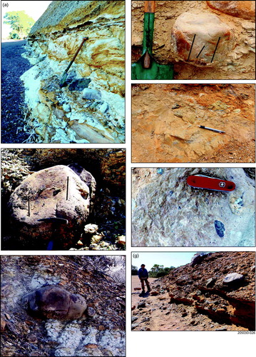
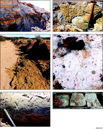
Figure 15. Quartz grain micromorphology at other sites. (a) Grain with multiple conchoidal fractures and grooves containing striae. Direction of grooves shown by arrows. Mt Fitton east site. (b) Conchoidally fractured quartz grain showing slight rounding of fracture edges in upper left half of grain. Grooves and striae on surface within rectangle. Chimney Springs–Petermorra Creek site. (c) Subrounded quartz grain with multiple grooves (arrows), pinhead striae (in rectangle) and striae (S). Billy Springs Creek–Dog Fence site. (d) Broad grooves (arrowed) crossing old conchoidal fracture surface from Hauterivian age diamictite in Cadna-owie Formation, Skeleton 2 drill hole. (e) Fractured grain exhibiting groves in upper left (area arrowed). Livingston Tillite Member in Yalkalpo 1 drill hole.
Village Well
Seven kilometres to the north of Pelican Well at the Village Well site (), Cadna-owie Formation consists of bouldery conglomeratic, trough cross-bedded medium to coarse-grained sandstone that is strongly ferruginous near the base. A laterally persistent tillite varying between 0.5 and 2.0 m in thickness is present. The tillite has a sandy to clayey matrix in which are set clasts to boulder size, the shapes of which vary from rounded to angular; they are facetted, polished and in places striated. A few worm burrows occur in the lower cross-bedded sandstone and in a thin sandstone lens immediately below the tillite. At one locality the sequence has the appearance of a Cenozoic fluvial deposit, but at the base of the measured section it is overlain by Cadna-owie Formation.
Drill-hole cuttings at the surface surrounding an abandoned mineral exploration well (Western Mining Limited VP8 drill hole) in the lower part of the Cadna-owie Formation along the line of our measured section were sampled for palynological dating, producing an excellent palynoflora to which a Valanginian age was ascribed.
Billy Springs Creek–Dog Fence site
An excellent exposure of the Livingston Tillite Member occurs at our Billy Springs–Dog Fence site, about 13 km ENE of the Recorder Hill type section (). At the base of the section are several metres of bioturbated, micaceous, partly carbonaceous, silty fine sandstone with some pebbles, which was sampled for palynological dating and produced a Valanginian age.
Figure 16. Lithologs for key sites along the northern margin and within the ranges, showing the stratigraphic position of the Livingston Tillite Member.
This is overlain by at least 6 m of pebbly to bouldery, cross- and level-bedded medium and coarse sandstone. Some of the larger clasts are dropstones, penetrating the beds below. These sediments are rapidly succeeded by interbedded, cross-bedded medium and coarse sandstone and tillite. This unit is characterised by small sandstone to conglomeratic channel insets, some cutting well into underlying beds.
Boulders in the tillite are rounded to angular, with some highly polished and facetted. Present are a variety of fine-grained quartzite, pink sandstone, gneiss, granite (including Terrapinna Granite), dark coloured volcanic and chert; one large quartz boulder was observed. The tillite matrix is also variable being sandy and gritty at the creek section but, at the thickest section, is much finer, strongly resembling the muddy matrix of the Livingston Tillite Member at the type section.
Quartz grains from a sample of the tillite facies show complex, multiple conchoidal fracturing on numerous grains, indicating a complex history of fracturing. Lunate fractures, grooves and striae are relatively common with some grains exhibiting chatter marks associated with grooves. The frequency of grains that are conchoidally fractured, grooved, striated and with some supporting chattermarks and lunate fractures is indicative of glacial transport ().
The remainder of the Cadna-owie Formation from 9.0 to 31.0 m level consists of interbedded bioturbated level bedded and trough cross-bedded medium to medium fine sandstones, bouldery sandy mudstones, minor siltstone with slightly carbonaceous mudstone near the base. Pebbles and boulders of mainly rounded and polished quartzite are common throughout with a few lenses of tillite and minor conglomerate in zones where boulders and pebbles are more common. Some of the large boulders in the lower part of the facies exhibit glacial characteristics, including polished surfaces, facetting and in places striae.
Chimney Springs–Petermorra Creek site
A fairly continuous section of Cadna-owie Formation can be traced from the bedrock unconformity to the unconformity with the Bulldog Shale at the Chimney Springs–Petermorra Creek site, the lower 6 m of which we include in the Livingston Tillite Member (). At the base is gritty, bouldery, calcareous cross-bedded sandstone in which the boulder and pebble fraction exhibits a great range in clast size and shape, with many very angular, and with common quartzite (dominant), granite, volcanics (a dark variety), gneiss and milky quartz. At 1.0–6.0 m pebbly, partly bioturbated trough cross-bedded medium to coarse sandstone contains lenses of gravel and boulders, which become more common near the top of this part of the unit. The boulder/gravel lenses may consist of gritty tillite with intraclasts of pebbly fine sandy silt and blocks of gritty sand. Some boulders are greater than a metre in diameter and polished, facetted and striated. The lithologies of the boulders include quartzite (dominant), sandstone, gneiss, granite (including Mt Neill Granite type), dark volcanics (including porphyry) chert, milky quartz, conglomerate, tillite (probably Neoproterozoic Bolla Bollana Tillite) and limestone.
Considerable rounding after conchoidal fracturing, including rounding of plate edges, is common on the quartz grains, a few grains exhibiting grooving (). The conchoidal fracturing of many grains, followed by subsequent rounding in association with other grains exhibiting only conchoidal fracturing or minor v-shaped percussion fractures, indicates glacial and fluvial transport. Some grains exhibiting grooves and striae have been transported by glacial ice. Given the tillite is a lens within bouldery coarse-grained cross-bedded sandstone strongly suggests a proximal fluvioglacial ice-contact setting and thus the lens of tillite could be a flowtillite.
Good palynological dates of Valanginian age were obtained on the carbonaceous mudstone immediately above the glacigene facies, indicating an age at least that old for the facies. The partly bioturbated, carbonaceous mudstones from 10 to 20 m, which contain extensive boulder beds (many as dropstones), conglomerate and tillite lenses, many with glacial characteristics, are dated palynologically as Hauterivian. The latter age and the presence of facies of glacial aspect indicate the glacial and/or freezing conditions extended into the Hauterivian.
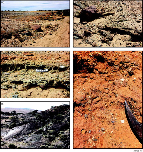
Gunpowder valley (west)
A tillite facies at the base of the Cadna-owie Formation and immediately overlying bedrock is exposed at the Gunpowder valley (west) site (). At this site tillite is platy to massive and contains abundant angular to rounded clasts of varied lithologies, in particular quartz, quartzite, Mudnawatana Tonalite, Terrapinna Granite, weathered granite, possibly Mt Neill Granite type, pegmatite, biotite schist, a variety of gneisses and weathered metamorphic lithologies, set in a slightly clayey, gritty matrix. Some pebbles and boulders are rounded, polished and facetted in a fashion characteristic of glacially deposited sediments. The tillite is overlain by 2.5 m of sandstone containing boulders and dropstones, then 6.5 m of level bedded, slightly bioturbated fine to medium sandstone containing carbonaceous horizons. Unfortunately, the latter produced no palynological assemblages.
Mt Fitton east
At the base of the succession at Mt Fitton east are a few metres of tillite in which the pebbles vary in size and shape from angular to round and some clasts are facetted, polished and in places striated. The matrix is a mixture of sand, silt and clay and is plastered onto the underlying bedrock and even squeezed into joints and fissures in the rock. The clasts consist dominantly of quartz and quartzite, with lower frequencies of Bolla Bollana Tillite, sandstone, Terrapinna Granite, chert, dark volcanics and rare Mt Neill Granite.
Quartz grain micromorphology shows an abundance of conchoidal fracturing along with other features such as striae and grooves indicating transport by glacial ice (). The rounding off of the fractures on some grains suggests subsequent fluvial modification either in a very proximal ice-contact proglacial or subglacial setting.
Dead Tree site
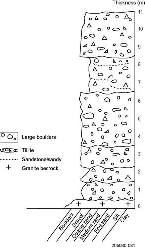
Along the eastern side of the Flinders Ranges near the Beverley Uranium Mine, a tillite bearing striated, facetted and polished pebbles and boulders crops out at the range front. The locality is referred to as the Dead Tree site (Hill & Hore, Citation2011; Hore & Hill, Citation2009). At this site, a tillite at least 11 m thick directly overlies bedrock (). The basal few metres are a silty to sandy tillite that is succeeded by a pebbly clast to matrix-supported tillite. The upper 4.5 m of the succession is pebbly sandstone to silty tillite.
Figure 17. Litholog for the diamictite at the Dead Tree site.
The stratigraphic position of the tillite within the Mesozoic succession at the Dead Tree site is not certain, but it has been tentatively correlated with the Livingston Tillite Member (Hill & Hore, Citation2011; Hore & Hill, Citation2009). However, the younger Sheehan Tillite Member, which locally has a similar thickness and lithology, can be seen in a comparable stratigraphic position overlying bedrock in the Paralana hot springs area, there overlain and interfingering with Trinity Well Sandstone (Hore, Hill, & Alley, Citation2020; see below). Thus, it is possible that the tillite at Dead Tree site might be the younger Sheehan Tillite Member.
Yalkalpo 1 drill hole
A well-dated succession of Cadna-owie Formation and Bulldog Shale is intersected in the Yalkalpo 1 drill hole to the southeast of Lake Frome. At the base of the Cadna-owie Formation is thin, very fine sandstone containing plant matter. This is overlain by interbedded diamictite and thin conglomerate (). The diamictite has a fine-grained pyritic matrix and contains rounded to angular pebbles of igneous lithologies including granite and reddish porphyry, metamorphics, silicified green siltstone/shale and quartzite, which Callen (Citation1972) believed were derived from the Benagerie Ridge. The diamictite is overlain by very fine micaceous mudstone containing thin layers of diamictite, plant matter, dolomitic zones and in places pebbles.
Figure 18. Litholog for Yalkalpo 1 drill hole showing the stratigraphic position of the Livingston Tillite Member and the ages derived by palynological dating.
Quartz grain micromorphology of a sample of the diamictite showed numerous angular grains with conchoidal fracturing, many of which exhibit multiple conchoidal fractures, including fractures across fractures. Some rounded grains exhibit conchoidal fracturing on some parts, while there is some rounding after fracturing on other grains. In places striae and grooves are present on fracture surfaces. Many of the above features are indicative of glacial crushing and grinding. The presence of grains with rounding after conchoidal fracturing suggests fluvial modification after glacial transport, possibly in a proximal fluvioglacial setting ().
The basal unit containing the tillite layers has been dated by palynology as Valanginian in age (; Morgan, Citation1980). Given this age, the lithology, the quartz grain micromorphology and stratigraphic position in the Cadna-owie Formation we regard this unit as a tillite correlative of the Livingston Tillite Member.
Trinity Well Sandstone
The Trinity Well Sandstone occurs largely in outcrop around the margins of the ranges where it varies in thickness 6–19 m, and at the type section is 12 m thick. Generally, the Trinity Well Sandstone is a medium to coarse, in places gritty, cross-bedded sandstone containing finer sandstone beds, conglomerate, tillite (some as lenses), pebbles and boulders (). It is weakly bioturbated throughout, although some parts are strongly bioturbated, and contains minor carbonaceous intervals and terrestrial and marine macrofossils. Our dating and correlation with well-dated drill-hole sequences shows the age of the Trinity Well Sandstone to be early (earliest?) Aptian.
Figure 19. Stratigraphic setting of the Sheehan Tillite Member and its inferred lateral relationship with the Cadna-owie Formation in deeper parts of the Eromanga Basin.
In the southwestern Eromanga Basin, the correlative Mt Anna Sandstone Member () is a medium to coarse-grained sandstone containing beds of conglomerate and abundant pebbles and boulders (Wopfner, Freytag, & Heath, Citation1968, Citation1970). Along the southeastern part of the Eromanga Basin the correlative Wyandra Sandstone is coarse cross-bedded, calcareous quartzose sandstone containing locally abundant pebbles, cobbles and boulders (Greenfield, Gilmore, & Mills, Citation2010; Senior, Exon, & Burger, Citation1975), similar to that exposed at the type section of the Trinity Well Sandstone.
We have discontinued the use of Trinity Well Sandstone unit as a Member of the Cadna-owie Formation because an unconformity of regional extent encompassing most or all of the Barremian separates the two units and thus the Trinity Well Sandstone is a formation in its own right. An erosional surface separates the Trinity Well Sandstone from the overlying Bulldog Shale or Marree Subgroup at many localities.
The Trinity Well Sandstone was deposited in a high energy wave foreshore to shoreface setting typical of offshore bars with channel influence. In the eastern and central part of the Eromanga Basin the correlative Wyandra Sandstone is interpreted to be a marine regressive unit (Gorter, Citation1994) and Morton (Citation1982) working on an equivalent sandstone in the area regarded it to be deposited in a marine shoreface setting. In southwestern Queensland Etheridge, McMinn, Smyth, Walsh and Davies (Citation1986) determined the Wyandra Sandstone to be a deltaic–lagoonal–emergent bar deposit and in the more central part of the basin, Newton (Citation1986) interpreted the unit to be a nearshore deltaic deposit.
Type and reference sections of the Sheehan Tillite Member
The Trinity Well Sandstone includes the Sheehan Tillite Member for which the type section is several kilometres west of Terrapinna water bore (loc. 373700E 6692000N) with reference sections at Parabarana Hill (loc. 375312E 6681300N) and just west of Gunpowder Bore (loc. 367761E 6697848N).
Type section west of Terrapinna water bore
The type section of the Sheehan Tillite Member in the Trinity Well Sandstone () commences with a strongly trough cross-bedded medium to coarse calcareous sandstone containing pebbles and boulders of a variety of lithologies, many of Mt Painter and Mt Babbage inlier provenance. The Trinity Well Sandstone unconformably overlies Cadna-owie Formation. Near the top of the Trinity Well Sandstone are fossils of Lingula and Cyrenopsis, worm burrows and rare Diplocraterion burrows, indicating that deposition was in a nearshore shallow marine setting. The uppermost part of the sandstone is gritty and medium-grained, containing some angular quartz pebble and is heavily bioturbated.
Figure 20. Lithologs for the Sheehan Tillite Member and relationships with the older part of the Cadna-owie Formation and the younger Marree Subgroup. A is the type section, B reference section at Parabarana Hill and C reference section at Gunpowder Bore.
The bioturbated sandstone is unconformably overlain by approximately 3.0 m of bouldery sandstone and tillite that we designate as the type section of the Sheehan Tillite Member (location 374050E 6691899N). From the base, the glacigene unit comprises:
up to 1.2 m thick, varying in thickness laterally, slightly bioturbated, very gritty quartz-rich conglomerate, largely horizontally bedded to massive with minor cross-bedding; clast shape varies from very rounded to very angular, although dominant shape is subrounded; lithology of the larger clasts includes Terrapinna Granite, mica-rich quartzite, Mt Neill Granite, quartzite (some pink and reddish), siltstone, Wattleowie Granite, micaceous schist; some clasts are polished and facetted, with some boulders bearing striae ();
Figure 21. Sheehan Tillite Member at the type section. (a) Large polished and facetted quartzite boulder in the tillite facies at the type section. (b) Large boulder of Terrapinna Granite in the tillite facies, type section.
variable thickness (at least 40 cm) of slightly calcareous, tillite, with a clayey to sandy matrix, containing angular to rounded clasts of variable orientation, some with polished and facetted surfaces; clast lithologies similar to the underlying conglomerate, although red porphyry clasts are also present;
40 cm medium to coarse, slightly silty, crudely laminated sandstone; and
20 cm pebbly, coarse sandstone containing rounded to angular clasts of quartz and metamorphic lithologies.
Above the Sheehan Tillite Member 9.0 m of Marree Subgroup occurs; this thickens northeastwards towards a low hill underlain by the subgroup.
Based on a range of clasts shapes and distal lithologies, along with the presence of polished, facetted and striated pebbles and boulders, we interpret the upper bouldery sandstone and tillite unit to be glacial in origin. We do not regard the clasts to have been derived from the nearby outcropping Neoproterozoic Bolla Bollana Tillite because none of the clasts in the Sheehan Tillite Member show any signs of tectonic stretching and alteration, typical of the older unit. In any event, the diversity of igneous and metamorphic lithologies within the Sheehan Tillite Member indicates that the clasts were not derived from the Bolla Bollana Tillite, because the Mt Painter and Mt Babbage inliers (the potential source for the crystalline rocks) were covered at the time of deposition of the latter glacial unit (Preiss, Citation1987).
The micromorphology of the quartz grains from a sample of the Sheehan Tillite Member at the type section strongly supports the interpretation of the larger clasts to be of glacial in origin. The quartz grains show evidence of abundant mechanical crushing and fracturing, with extensive conchoidal fracturing. This, along with grooves and striae, is indicative of glacial transport. Subsequent rounding to fracturing on some grains suggests a measure of water transport either subglacially or in a proximal ice-contact setting ().
Figure 22. Quartz grain micromorphology at the type section of Sheehan Tillite Member. (a) Grain with multiple conchoidal fractures. (b) Multiple conchoidal fractures along the sharp edge of a quartz grain. (c) Grain showing rounding of conchoidal fractures (central part of grain). (d) Grain showing striae and grooves (direction shown by black arrow). Pinhead striae at point of yellow arrow. (e) Grain with grooves and striae shown within yellow rectangle. (f) Enlargement of (e) showing the grooves and striae cutting across older conchoidal fractures.
Parabarana Hill reference section
At the Parabarana Hill reference section a significant zone of very gritty sandstone containing the Sheehan Tillite Member and lenses of angular to rounded boulders occurs at the 12.5–14.5 m level in the Trinity Well Sandstone ( and ). Along strike to the south the bed separates into lenses of tillite and boulders within sandstone. Some of the boulders are rounded, polished and facetted. There is a mixture of boulder lithologies, the most common being a variety of quartzites, gneiss, granite, including Mt Neill Granite, and milky quartz.
Figure 23. Sheehan Tillite Member, Parabarana Hill reference section. (a) Looking south along the strike of the tillite facies (yellow dashed line) at the Parabarana Hill reference section. (b) Block of tillite facies of the Sheehan Tillite Member. (c) Vertical view of a bedding plane surface with unsorted quartz and quartzite pebbles and boulders (many as dropstones) in coarse sandstone Trinity Well Sandstone, at the 20–21 m level, associated with marine fossils. Large white quartz pebble 9 cm long. (d) Cluster of Lingula subovalis in the upper Trinity Well Sandstone. Twenty cent coin in lower right for scale. (e) Block of Trinity Well Sandstone (in close vicinity to the Lingula fossils) containing impressions of Cyrenopsis? fossils. Part of pocket knife 5 cm in length for scale in lower left. (f) Rhizocorralium burrow in sandstone above the Sheehan Tillite Member facies. (g) Impression of starfish on the surface of a block of Trinity Well Sandstone. Maximum diameter 12 cm.
The tillite within the Trinity Well Sandstone contains large clasts with glacial features. Thus, we regard the unit to be glacial in origin and deposited by a glacier emanating from the ranges in close proximity to the west. The interpretation is supported by the micromorphology of the quartz grains, which are distinctly glacial in aspect, although with some rounding subsequent to glacial crushing, suggesting proglacial influence either subglacially or in a proximal ice-contact setting ().
Figure 24. Quartz grain micromorphology for the Sheehan Tillite Member at Parabarana Hill reference section. (a) Conchoidal fractures on edge of rounded grains. (b) Grain with multiple conchoidal fractures. (c) Sharp-edged conchoidally fractured grain exhibiting grooves and striae (arrowed). (d) Conchoidally fractured grain subsequently grooved and striated (arrowed).
The upper, bouldery sandstone of the Trinity Well Sandstone containing tillitic lenses at the Parabarana Hill site may be proglacial, with deposition occurring as lenses of morainal debris shed from icebergs floating in a shallow sea as the glacier melted. Thus, this part of the succession could be regarded as glacio-marine, with deposition in a shallow offshore bar setting, as indicated by the presence of abundant fossils of the Lingula and Cyrenopsis associated with Diplocraterion tracks ().
Gunpowder Bore site
A third reference section is at the Gunpowder Bore site ( and ). Here the tillite is exposed in low, south-facing ledges of Trinity Well Sandstone extending westwards from Gunpowder Bore. The beds dip gently to the north, outcrop is not continuous, and the base of the sandstone not exposed (), although a kilometre to the east the base rests on bedrock ().
Figure 25. Sheehan Tillite Member at the Gunpowder Bore reference section (a) Large boulders of red porphyry and greenish quartzite in the tillite facies, Gunpowder Bore reference section. (b) Red porphyry boulder in sandy, pebbly tillite facies, Gunpowder Bore reference section. 10 cm ruler to right of boulder. (c) Sandy, pebbly tillite facies, the upper part strongly bioturbated, Gunpowder Bore reference section. 10 cm ruler for scale. (d) Sheehan Tillite Member in the Trinity Well Sandstone, exposed in cliff to the east of Gunpowder Bore. (e) Polished surface on Terrapinna Granite (lower centre and left) surface being exhumed from below the Trinity Well Sandstone outcropping in upper right. Mt Yerila on horizon.
From the base, the sandstone comprises:
0.0–0.5 m of coarse trough cross-bedded sandstone with very rare pebbles and indistinct bioturbation; and
0.5–4.6 m interbedded tillite beds and lenses and cross-bedded, partly calcareous fine to medium sandstone containing pebbles and rare clusters of small pebbles, all of which we include in the Sheehan Tillite Member.
The basal tillite has a sandy to silty matrix, is strongly bioturbated in the upper part and mildly so throughout and may exhibit cross-bedding. Large boulders are present, including of red porphyry and quartzite (a number of varieties), quartz, mafic rocks, schist, granite, siltstone and slate. Clast shape ranges from rounded to angular and clasts can be polished and facetted.
The cross-bedded sandstone contains thin layers and lenses of tillite, isolated boulders of various lithologies and rounded, polished and facetted pebbles.
The upper, bioturbated, indistinctly cross-bedded sandy tillite contains pebbles and boulders, dominantly angular quartz clasts and lesser quartzite, which may be facetted and polished, siltstone and rare igneous lithologies.
The succession was deposited in shallow water marine conditions and appears to represent a lodgement till, separated by proglacial sediments, containing lenses of till and boulders shed from floating ice, from an upper flowtill, deposited in an ice marginal setting.
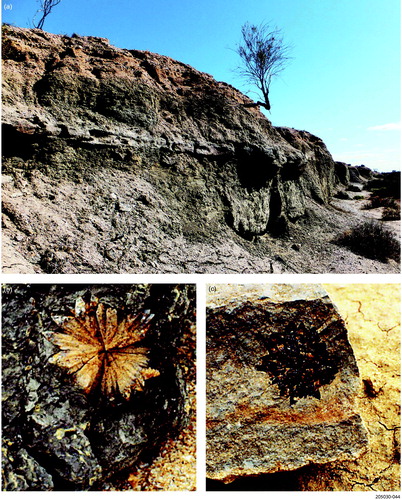
Polished bedrock surfaces occur on a number of granite outcrops around the northern margin of the Flinders Ranges, especially in the vicinity of the Gunpowder Bore reference section for the Sheehan Tillite Member ( and ). These have been attributed to wave polishing probably during the transgression which led to deposition of the Bulldog Shale or Cadna-owie Formation (Sheard & Flint, Citation1992). Sites in the Gunpowder Bore valley are emerging from beneath a cover of Trinity Well Sandstone, containing Sheehan Tillite Member, and at a site near the Chimney Springs–Petermorra Creek site the polished rock surface is overlain by Cadna-owie Formation. Thus, the formation of the polishing owes its origin to processes operating during deposition of these two latter deposits, both containing glacial sediments. At site 2 of Sheard and Flint (Citation1992), the bedrock is polished (although suffering from weathering) and exhibits striae ().
Figure 26. (a) Malcolm Sheard inspecting polished and striated surface developed on Terrapinna Granite west of Gunpowder Bore. (b) Polished Terrapinna Granite at the same site as photo (a) exhibiting striae trending slightly to the right away from the viewer. (c) Polished, grooved and striated surface developed on quartzite, Lagoon Hill, west of Lake Eyre. (d) Closer view of polish, grooving and striae cutting obliquely across the joints in the bedrock.
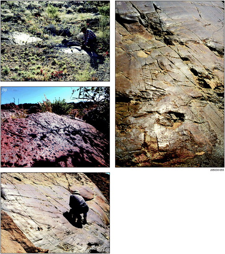
We have examined the surfaces closely, including the polished surface at Lagoon Hill west of Lake Eyre referred to by Sheard and Flint (Citation1992) and reported in Rogers and Freeman (Citation1996). Owing to the poor exposure at the latter site there is uncertainty about whether the polished surface is overlain by either Cadna-owie Formation or Bulldog Shale. We conclude on the basis of the polished surface exhibiting striae and grooves that the surface is glacial in origin ().
Other significant sites
Pelican Well and Village Well sites
Exposed at Pelican Well site, in Pelican Creek, are about 7 m of planar to trough cross-bedded sandstone underlain by Cadna-owie Formation and overlain by Bulldog Shale (). The sandstone consists of a series of tidal bundle facies. The latter is well described by Lemon (Citation1988) and consists of a series of cross-bedded, largely medium-grained sandstone beds, with coarser beds at the base and finer in the upper part (). The sandstones are interpreted to show evidence of deposition as tidal bundles in an estuarine setting (Lemon, Citation1988). Based on the orientation of the foreset beds, Lemon (Citation1988) recorded current directions varying between 235 and 280° but we also observed directions of 330–340°. We regard the facies, which also occur at another site several kilometres ENE, to be the southern part of a large outwash fan extending northwards to include the type section of the Trinity Well Sandstone at Village Well.
Figure 27. Sheehan Tillite Member characteristics. (a) Tidal bundle facies at Pelican Well site. Spade 75 cm length. (b) Polished, facetted and rounded quartzite boulder exhibiting striae within gritty conglomerate in the upper sandstone (323989E 6692994N). Western Spur in the distance. Two-dollar coin for scale. (c) Tillite lenses in Trinity Well Sandstone at same site as (b). (d) Large polished, facetted and striated boulder in Trinity Well Sandstone at same site as (b) and (c). (e) Clast of Wattleowie Granite in the basal tillite of the sandstone, Western Spur (322802E 6691543N). (f) Boulder of Mt Neil Granite in the upper bouldery Trinity Well Sandstone at Mt Fitton (east) site. (g) Tillite in upper calcareous Trinity Well Sandstone exposed along creek immediately west of Mt Fitton Homestead (abandoned) (loc. ∼360320E 6683460N). (h) Striated quartzite boulder in upper Trinity Well Sandstone at Mt Fitton (east) site.
The upper surface of bedding planes within the Trinity Well Sandstone at its type section at Village Well are well exposed and exhibit abundant facies variations. Broad-scale trough cross-bedded and planar cross-bedded medium and coarse sandstone containing abundant pebbles of angular to rounded quartz, quartzite, sandstone and siltstone, but particularly in the upper part ( and ). In places quartzite boulders are rounded, polished and facetted, with several quartzite boulders bearing striae. Lenses of tillite are associated with these boulders and, given their stratigraphic position, together are correlated with the Sheehan Tillite Member.
At Western Spur, several kilometres to the west of the type section at Village Well site, the Trinity Well Sandstone is thinner and reaches about 10 m in thickness and sits on an irregular sloping uniformity on the Cadna-owie Formation. Lying along the unconformity surface is a thin bed of conglomerate containing lenses of tillite with boulders, which have travelled at least 40 km from source, including Wattleowie Granite and pegmatite. We interpret this to be part of the Sheehan Tillite Member ().
Together we regard the sandstones and Sheehan Tillite Member facies at Pelican Well, Village Well and Western Spur to be part of a large proglacial outwash fan with the terminus of the glacier lying nearby within the ranges to the east (see below).
Mt Fitton Homestead and Mt Fitton east sites
About 10–12 m of partly calcareous, trough cross-bedded medium to coarse, gritty and very bouldery sandstone containing thin lenses of sandy tillite and one tillite bed outcrop at the Mt Fitton east site. This sandstone unit sits on an erosional unconformity formed on the Cadna-owie Formation. The western side of the succession sits on a relatively steep bedrock slope formed across Bolla Bollana Tillite and Wattleowie Granite.
Large to very large boulders in this uppermost facies may be rounded polished, striated and facetted and in places associated with the tillite lenses and a sandy tillite bed (). The lithology of the boulders and pebbles is dominated by quartz and quartzite, with lower frequencies of volcanic rocks, Mt Neill Granite, Balcanoona Formation stromatolitic limestone, red porphyry, Bolla Bollana Tillite, granite (unknown designation), sandstone and chert.
Thin outcrops of pebbly to bouldery calcareous cross-bedded sandstone, which we correlate with the Trinity Well Sandstone along the creek immediately west of Mt Fitton Homestead (abandoned), contains a tillite bed at least 1.5 m thick (). The facies here is associated and partly intercalated with fine, medium and coarse gritty sandstone containing casts of shells and fossil wood.
Paralana hot springs area
Two outliers of Cadna-owie Formation overlain by Trinity Well Sandstone occur along the range front about 4 km south of Paralana hot springs (). The Trinity Well Sandstone at these sites is largely coarse pebbly trough cross-bedded sandstones.
Figure 28. Lithologs for the Mesozoic units south of Paralana hot springs showing Sheehan Tillite Member overlying the Cadna-owie Formation.
In the southern outcrop the upper coarse sandstone is gritty and contains angular to subangular quartz clasts along with some rounded quartz pebbles. The lithologies of the clasts are quite varied and reflect the basement rocks to the west. At the base of the unit at the northern exposure is about 1.0 m of tillite containing rounded, polished facetted and in places striated pebbles. This is overlain by 5.0 m of calcareous, coarse gritty sandstone dominated by angular grains and rare rounded pebbles.
On the basis of its glacial characteristics and its stratigraphic position, a correlation of the tillite is made with the Sheehan Tillite Member. A tillite 9 m thick resting directly on bedrock and overlain and interfingering with Trinity Well Sandstone, which occurs in close proximity to the hot springs, has also been correlated with the Sheehan Tillite Member (Hore et al., Citation2020). The thickest tillite of this member thus far observed is preserved at this locality. As noted earlier the tillite exposed at the Dead Tree site and tentatively correlated with the Livingston Tillite Member (Hill & Hore, Citation2011; Hore & Hill, Citation2009) is more than likely to be Sheehan Tillite Member.
Marree Subgroup
Dropstones and lonestones
The lonestones and dropstones, many with glacial characteristics and associated with lenses of diamictite throughout the Aptian part of the Marree Subgroup (Bulldog Shale), strongly suggest the persistence of cold conditions capable of producing seasonal freezing and even limited glacial ice during most of the remaining Aptian ().
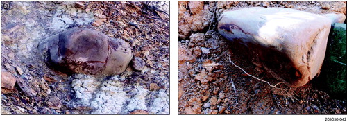
Figure 29. Dropstones and associated diamictite in Bulldog Shale, creek exposure west of Trinity Well. (a) Isolated dropstone (at hammer point) with facetted and polished surface. (b) Line of dropstones in Bulldog Shale. (c) Diamictite containing polished and facetted pebbles associated with large dropstone of dark volcanic rock.
The dropstones in the Bulldog Shale and Cadna-owie Formation were considered to be due to seasonal freezing and rafting of boulders out into the sea in the spring melt (Alley & Frakes, Citation2003; Alley et al., Citation2011; de Lurio & Frakes, Citation1999; Frakes & Francis, Citation1988, Citation1990; Frakes & Krassay, Citation1992; Frakes et al., Citation1995). Many of these boulders are quite large () and would require a significant volume of ice to float the boulders and a significant depth of river water to allow this to occur. This is unlikely to occur in seasonal freezing along a meltwater stream, but more is likely by calving from a glacier terminating in the sea.
Figure 30. Large dropstones and lonestones. (a) Large facetted and polished quartzite dropstone (∼1.25 m long) in Cadna-owie Formation, Billy Springs Creek–Dog Fence, site. (b) Polished and facetted quartzite dropstone in Bulldog Shale, Petermorra Creek area. Spade head ∼25 cm long.
Rafting by floating trees where the boulders are caught in the root mass has also been considered but discounted because direct evidence has not been observed in the Eromanga record (Frakes et al., Citation1995). There is no question that trees can float from forested areas along larger rivers into ice-prone areas, as demonstrated by the abundance of logs floating in the Arctic Ocean, many being transported down the Mackenzie River (Pielou, Citation1991). Given the glacial characteristics of many of the boulders, however, an ice transport mechanism is more likely. Alley et al. (Citation2011) suggested that because of glaciers during the Early Cretaceous, transport might be by icebergs derived from calving of glaciers where they stagnate in shallow water, a proposal which is supported by the evidence around the southern margin of the Eromanga Basin.
Diamictites
At several localities, a diamictite or boulder bed, containing clasts with glacial characteristics, may indicate the growth of limited glaciers in the later Aptian. Underlying the Marree Subgroup at the Parabarana Hill and Petermorra Creek sites are bouldery diamictites and/or boulder beds (). Some of the clasts in these diamictic layers have distinct glacial features including surface polish, facetted sides and striated surfaces and may well be glacial in origin. At the Parabarana Hill site the diamictite has been plastered onto the upper surface of the Trinity Well Sandstone. The dating here suggests this diamictite could be latest Aptian to early Albian in age.
Figure 31. (a) Aptian diamictite at Parabarana Hill site. Pebbly diamictite plastered onto surface of steeply dipping to almost vertical Trinity Well Sandstone. Spade 75 cm in length. (b) Looking along the exposure of diamictite (to right of spade, 75 cm length, and right foreground) with steeply dipping Trinity Well Sandstone (to right of red haversack). (c) Polished, facetted and striated quartzite boulder excavated from diamictite; lines show orientation of striae. (d) Rounded, striated and polished quartzite boulder with lines showing orientation of striae. (e) Polished, facetted and striated boulders and thin diamictite at the base of Bulldog Shale (dark sediment above and to right), overlying reddy brown Cadna-owie Formation, Petermorra Creek area.
At the Chimney Springs–Petermorra Creek site a boulder bed containing diamictite lenses with some pebbles and boulders exhibiting glacial characteristics occurs at the base of the Bulldog Shale (). The overlying Bulldog Shale appears to have been deposited penecontemporaneously with the diamictite/boulder layer. The age of the Bulldog Shale here is middle to late Aptian, perhaps extending into the early Albian, an age thus similar to that determined for the tillite at the Parabarana Hill site.
While there is some uncertainty about the age of the presumed glacial event that led to the deposition of this thin diamictite, it appears to have occurred in the late Aptian to early Albian.
Glendonite crystals
The occurrence of a zone of glendonite crystals in the Bulldog Shale () has been used as evidence for a cold climate in the Aptian (de Lurio & Frakes, Citation1999; Frakes et al., Citation1995; Sheard, Citation1991). We have correlated marine microplankton found in calcareous concretions containing glendonite crystals and from the Bulldog Shale surrounding the crystals with the Diconodinium davidii dinoflagellate zone of late Aptian age.
Figure 32. Glendonite crystals in Bulldog Shale, Petermorra Creek. (a) Creek bank exposure of slightly weathered Bulldog Shale, Petermorra Creek. (b) Calcitic glendonite crystal in situ Petermorra Creek in relatively fresh Bulldog Shale. (c) Calcitic and gypsiferous glendonite crystal in situ Petermorra Creek in slightly sandy and weathered Bulldog Shale.
Glendonite crystals are calcite pseudomorphs after metastable ikaite and are known only from anoxic marine sediments that form at temperatures below approximately 12°C (Purgstaller, Dietzel, Baldermann, & Mavromatis, Citation2017). In addition to the near freezing water, the formation of ikaite requires a tenfold increase in alkalinity relative to normal seawater and elevated concentrations of orthophosphate, both the latter being met by organic matter in reducing environments, which is consistent with the depositional environment of the Bulldog Shale at this time (Alexander et al., Citation2006). The oxygen isotopic considerations of de Lurio and Frakes (Citation1999) also show that this part of the sea received a high influx of 18O-depleted freshwater, which they concluded resulted from melting of snow or ice fields. If at this time glacial conditions prevailed around the southwestern margin of the ‘Eromanga sea’, then some of the freshwater may well have come from melting glaciers.
Glacial events and reconstruction of ice cover
The pattern of ice cover has been reconstructed from the distribution of glacial sediments across the area. The presence of distinctive rock lithologies in the tillites and associated sediments, especially those clasts that have travelled long distances from their source in the bedrock have been used to infer ice flow directions.
Livingston Glaciation
Our palynological dating shows the Livingston Glaciation to be confined to the Valanginian, an interval of time some 7 million years long, but as we will show below the glaciation was probably limited to the middle Valanginian. The dropstones and lenses of flowtillite and conglomerate in the Cadna-owie Formation underlying the tillite are clear evidence that glacial ice was already influencing deposition around the margins of the ranges prior to the glaciers reaching their maximum extent.
Using the nearest source of distinctive clast lithologies found in the Livingston Tillite Member, enables potential transport directions to be mapped out. This is a proxy for the main directions of ice movement during the Livingston Glaciation. The distinctive lithologies in the Livingston Tillite are Mt Neill Granite, Mudnawatana Tonalite, Terrapinna Granite, dark volcanics, Bolla Bollana Tillite and Pepegoona Porphyry. Based on this distribution, the main source area is the current higher parts of the eastern Mt Painter Inlier, suggesting that ice grew along this part of the ranges first, and probably where the thickest ice developed, then radiating out from there. The occurrence of Pepegoona Porphyry and Mt Neill Granite at the Recorder Hill site, the type section of the Livingston Tillite Member, indicates more than 30 km of transport from the source.
We have been unable to locate any tillite to the south and east; any such evidence has probably been eroded or covered by younger sediment.
Clasts in the Livingston Tillite Member in Yalkalpo 1 drill hole were probably derived from the basement rocks of the Curnamona Province.
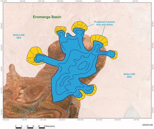
At the glacial maximum, glaciers extended beyond the range front and terminated in a shallow sea (). The facies deposited around ice margins and the palynological evidence show interplay of proglacial (freshwater) and shallow water marine conditions during deposition.
Figure 33. Reconstruction of Livingston Glaciation at its maximum. Proglacial outwash fans and deltas are shown in yellow.
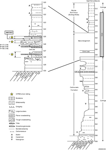
Lenses of conglomerate and flow tillite containing clasts with glacial characteristics are distributed throughout the Valanginian–Hauterivian section of the Cadna-owie Formation around the margins of the ranges. Thin diamictite of glacial character, including quartz grain micromorphology indicative of glacial transport, occurring along with fluvial sediments of Hauterivian age in Skeleton 2 drill hole (), demonstrate that some form of glacial influence extended some 30 km out from the range margin. The fossil plant evidence derived from the palynological evidence from the same stratigraphic interval as the diamictite suggests cool temperate forest existed at this time. The above evidence, along with dropstones exhibiting glacial features, such as striae, polish and facetting, within the same interval, indicates that limited glacial conditions may have persisted through much of Valanginian–Hauterivian time.
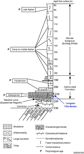
Figure 34. Litholog for the Cadna-owie Formation in Skeleton 2 drill hole showing the presence of Hauterivian age diamictites within core. Ages are shown in red letters: V, Valanginian; H, Hauterivian; and A, Aptian. Detrital zircon dates shown as yellow stars, but only sample 3 produced a date 117 ± 2 Ma relevant to the known ages of the succession.
Sheehan Glaciation
Using the nearest source of distinctive clast lithologies found in the Sheehan Tillite Member enables potential transport directions to be mapped out which is a proxy for the main directions of ice movement during the glaciation: evidence comes from the Mt Neill Granite, dark volcanics, Terrapinna Granite, Wattleowie Granite and Mudnawatana Tonalite ().
Figure 35. Upper left: interpreted transport directions for distinctive rock lithologies found as clasts in the Livingston Tillite Member. The inset map in the lower right shows potential flow directions for the tillite found in Yalkalpo 1 drill hole. Upper right: interpreted ice cover early in the Livingston Glaciation. Lower-left: interpreted transport directions for distinctive rock lithologies found as clasts in the Sheehan Tillite Member. Lower-right: interpreted ice cover early in the Sheehan Glaciation.
As with the Livingston Glaciation, the main source area is the current higher parts of the eastern Mt Painter Inlier. This suggests that ice was initiated along this part of the ranges and probably flowed out from there (). The presence of a clast of Wattleowie Granite in proglacial sediments in Trinity Well Sandstone at Western Spur suggests at least 40 km of transport from its source in the Mt Painter Inlier. This granite also crops out in the Mt Babbage Inlier, but given the general transport direction and the source of other clasts in the Mt Painter Inlier, the latter area is most likely the source.
The lack of evidence for ice movement to the south and east again may be due to erosion or coverage by younger sediment.
We interpret the glacial ice during this glaciation to have terminated in a shallow marine setting around the eastern and northeastern margin of the ranges (). The presence of an offshore bar at the Parabarana Hill site is interpreted from the in situ marine fossils (Lingula, Cyrenopsis and starfish) in the cross-bedded sandstone of the Trinity Well Sandstone in which the tillite sits. Also present are burrows of Diplocraterion and Rhizocorallium that are typical of shallow water offshore bar settings. The local abundance of plant remains also supports the above contention that deposition occurred in a nearshore environment.
Figure 36. Reconstruction of proposed glacial ice and associated proglacial sediments at the maximum of the Sheehan Glaciation.
Based on the presence of tidal bundle facies in the Trinity Well Sandstone at Pelican Well, on the northwestern side of the ranges, we suggest the presence of a tidal channel (). Nearby in the Village Well area, at the type section of the Trinity Well Sandstone, lenses of sandy tillite and conglomerate containing clasts of glacial aspect occur in cross-bedded proglacial facies of the sandstone. We regard this as an outwash fan deposited not far from the glacial ice margin.
The Mt Anna Sandstone is a lateral equivalent of the Trinity Well Sandstone and the pebbles and boulders it contains are possibly of proglacial origin. If so, they may have been derived from glacial ice flowing northwards from the Gawler Ranges. Around the southeastern margin of the Eromanga Basin in NSW, Greenfield et al. (Citation2010) reported exotic clasts, many as lonestones, in the Wyandra Sandstone, a correlative of the Trinity Well Sandstone. This distribution suggests the widespread presence of glacial ice around the southern margin of the Eromanga Basin during the early Aptian. However, because of the orientation of the Australian plate at the time (), glaciers appear to have developed along the western to southwestern side of the Eromanga Basin, then bordered by low ranges.
Later Aptian cold climate—evidence from the Marree Subgroup (Bulldog Shale)
The presence of the lonestones and dropstones, with glacial characteristics and associated with lenses of diamictite/tillite in the Aptian part of the Marree Subgroup strongly suggest the persistence of conditions capable of producing seasonal freezing and even limited glacial ice.
At the Parabarana Hill and Petermorra Creek sites, the presence of a tillite and boulder bed, containing clasts with glacial characteristics, at the base of the Bulldog Shale may also be indicative of limited glaciers in the later Aptian to earliest Albian. Glendonite crystals within the same stratigraphic interval support this notion.
Correlation of Early Cretaceous glacial events in the Southern Eromanga Basin with the global record
In the following:
the main climatic cooling events in the southern Eromanga Basin are outlined;
the global isotopic record and other evidence for climatic cooling during the Early Cretaceous is summarised; and
correlation of the global record with glaciation and other cold intervals in the southern Eromanga Basin is attempted.
Our reliance on palynological dating, while a useful tool for dating and correlation at a broader scale, has limitations; the biggest of these are (1) the length of the palynological zones and (2) the correlation of these with the global time-scale. If the Pleistocene were taken as a model for the length of glacial intervals, which are 10 000–15 000 years in length, this is clearly beyond the ability of palynological dating of glacial intervals in the Early Cretaceous. For example, the age of the Livingston Glaciation is placed within the Valanginian (), which occupies about 7 million years of time, but where in that stage cannot be determined by current palynological dating.
Summary of events in the Southern Eromanga Basin
The Livingston Glaciation lies somewhere within the Valanginian (), and this continues into the Hauterivian with evidence for the presence of either glacial ice (and icebergs) or seasonal freezing of rivers and the nearshore marine environment. This is followed by the hiatus in the Barremian.
Figure 37. Summary of interpreted glaciations and cold (periglacial?) intervals for the Late Jurassic–Cenomanian interval in the southern Eromanga Basin. Blue arrows represent the range of dropstones and diamictite lenses within the succession.
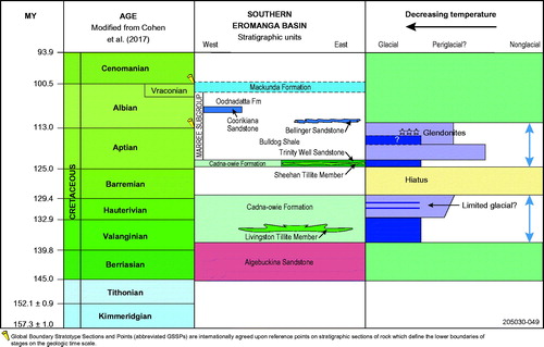
The timing of the Sheehan Glaciation () by palynological dating is a little more tightly constrained to somewhere in the earliest Aptian. Based on the distribution of glacial facies during this time, the glaciation does not appear to have been as extensive as the Livingston Glaciation.
The Sheehan Glaciation is followed by a relatively long interval extending from the early Aptian to late Aptian when dropstones and thin diamictite lenses and pods are present in the Marree Subgroup (Bulldog Shale). We have interpreted these to imply that floating ice, icebergs and/or seasonal ice was be present along the southern margin of the Eromanga Basin during this interval. The later Aptian, within the Diconodinium davidii microplankton zone, also has a thin layer of glendonite crystals that could only have formed in very cold conditions. This palynological zone covers at least 4–5 million years, but within that period when the glendonite crystals formed cannot be determined with current methods.
An enigmatic thin tillite/boulder layer occurs within the Marree Subgroup at several sites, but our dating of this layer is tenuous. At the Parabarana Hill site, it is older than 110 Ma, an age determined from detrital zircons from Bulldog Shale overlying the layer, so its age could be no younger than earliest Albian. At Petermorra Creek site, the tillite and boulder layer probably sit within Bulldog Shale only a few metres below the glendonite zone, which we date as late Aptian. Thus, the age of the layers could range from late Aptian to earliest Albian.
Correlation with the global record for cold climate in the Early Cretaceous
A widely held view that the global Cretaceous climate was greenhouse has been questioned by a number of authors, suggesting that there is evidence for significant cooling events in the supposed warm Early Cretaceous, especially during the Valanginian and Aptian (Alley & Frakes, Citation2003; Ditchfield, Citation1997; Donnadieu et al., Citation2011; Erba, Bartolini, & Larsen, Citation2004; Frakes & Francis, Citation1988; Frakes et al., Citation1995; Galloway et al., Citation2015; Gröcke et al., Citation2005; Kemper, Citation1983, Citation1987; Kessels, Mutterlose, & Michalzik, Citation2006; McArthur et al., Citation2004, Citation2007; Podlaha, Mutterlose, & Veizer, Citation1998; Price & Passey, Citation2013; Weissert & Erba, Citation2004).
A generalised oxygen isotope record has been used by Matthews and Poore (Citation1980) to imply ice buildup in Antarctica during the Cretaceous. Although this was challenged by Arbreu and Anderson (Citation1998) and Arbreu et al. (Citation1998) owing to the lack of physical evidence in Antarctica for the presence of glacial ice prior to the Middle Eocene, stable isotope studies increasingly have indicated cooler climatic conditions at high latitudes (Ditchfield, Marshall, & Pirrie, Citation1994; Erba et al., Citation2004; Huber, Hoddell, & Hamilton, Citation1995; Price, Sellwood, & Pirrie, Citation1996; Sellwood, Price, & Valdes, Citation1994; Stoll & Schrag, Citation1996). Sames et al. (Citation2016) reviewed the evidence for short term eustatic sea-level changes and continental water storage and concluded that the presence of large continental ice-masses was unlikely during the Early Cretaceous. However, they did recognise that sea-level falls appeared to be related to climatic changes triggered by astronomical cycles with a ca 1.0–2.4 my periodicity.
Carbon isotopes were used by Gröcke et al. (Citation2005) to suggest that cool conditions were widespread in the late Valanginian of the Northern Hemisphere, which was supported by work on nannofossils indicating cool climate extending from the late Valanginian into the Hauterivian (e.g. Kessels et al., Citation2006; Melinte & Mutterlose, Citation2001; Mutterlose & Kessels, Citation2000). A study of strontium, carbon and oxygen isotope stratigraphy, sedimentology, paleontology, clay mineralogy and the orbital record for late Valanginian in the Vocontian Basin, France, suggested that a transient cool, arid climate prevailed and was possibly associated with limited polar ice (Martinez, Deconinck, Pellenard, Reboulet, & Riquier, Citation2013). Using TEX86 and oxygen isotope analysis of planktonic foraminifera, O’Brien et al. (Citation2017) showed that intervals of cooling occurred in the Valanginian and Aptian.
Carbon and oxygen isotope data from the Early Cretaceous of Romania show warm temperatures in the early Barremian, then cooling followed by warming into the early Aptian, then significant cooling phases in the late Aptian and early Albian (Papp, Cociuba, & Lazăr, Citation2013). Reconstruction of atmospheric CO2 levels during the Early Cretaceous using pedogenic carbonates in Sichuan and Liaoning, China, led Huang, Retallack and Wang (Citation2012) to conclude that the CO2 levels were consistent with climatic cooling in the early–middle Berriasian and early Valanginian. A comprehensive review of atmospheric CO2 levels during the Cretaceous shows lower global CO2 levels occurred in the early to middle Valanginian, later Hauterivian to early Barremian and early and late Aptian (Barral, Gomez, Legendre, & Lécuyer, Citation2017). If all of these intervals of lower CO2 level were correlative with lower temperatures then cooling events may have been widespread during the Early Cretaceous, as is also suggested by our stratigraphic and sedimentological evidence (see below).
Such climatic trends are broadly paralleled by the variations in CO2 concentrations in the Earth’s atmosphere during the Early Cretaceous (reconstructed from fossil plant stomata characteristics) with warming trends related to higher concentrations of CO2. These show that while the levels remained relatively high throughout the Cretaceous, they were lower in the Early Cretaceous and interrupted by shorter phases of low CO2 levels in the Berriasian, Valanginian and Barremian to Aptian (Wang et al., Citation2014).
Oxygen isotope study of fossil fish tooth enamel from the Cretaceous Tethyan recognised major cooling events at million-year scale near the Berriasian–Valanginian boundary, late Valanginian and earliest Aptian (Pucéat et al., Citation2003, using the time-scale of Gradstein et al., Citation1994). We have converted those ages to the time-scale of Cohen et al. (2017; see ), which puts the two Valanginian events of Pucéat et al. (Citation2003) in the early and middle part of the Valanginian, respectively, and the Aptian event in the middle Aptian. Pucéat et al. (Citation2003) correlate the cooling intervals with the presence of glendonites at those times and conclude they represent cold conditions (Price, Citation1999). Some workers considered such temperature excursions may have allowed the growth of glaciers in high northern latitudes (e.g. Kessels et al., Citation2006; Price & Mutterlose, Citation2004; Price & Nunn, Citation2010; Price & Passey, Citation2013), although this had been suggested earlier by Ditchfield (Citation1997) from oxygen isotope analysis of belemnites from Spitsbergen. The only physical evidence for glacial ice, however, still remains to be the Valanginian age Livingston Tillite Member of the Cadna-owie Formation from the southern Eromanga Basin, South Australia (Alley & Frakes, Citation2003).
The presence of glendonite crystals in sediments has long been used as evidence of cold conditions at the time of their formation (Rogov et al., Citation2017). The investigations by the latter authors of late Berriasian age glendonite crystals in northeast Siberia show that cooling occurred during the interval. In their study of the paleoclimatic significance of glendonite crystals in high-latitude Valanginian and Aptian strata on Ellef Ringnes Island, Canadian Arctic, Grasby et al. (Citation2017) concluded that cold conditions existed in both stages, which confirmed the initial interpretation of Kemper and Schmitz (Citation1975, Citation1981) for the Sverdup Basin, that the presence of glendonites was indicative of cold snaps in the Valanginian and late Aptian–early Albian.
Glendonites in the Christopher Formation on Axel Heiberg Island (High Arctic) were used to infer that a cooling event in the late Aptian–early Albian had lasted for some 6 million years (Herrle et al., Citation2015). Late Aptian glendonites from the Bulldog Shale, Eromanga Basin, South Australia have been used to infer that the region (at that time at high latitudes) experienced at least seasonally colder conditions than previously accepted (de Lurio & Frakes, Citation1999; Frakes & Francis, Citation1988, Citation1990; Sheard, Citation1991). Ikaite is also known from deep ocean water where temperatures are ∼3°C (Jansen, Woensdregt, Kooistra, & van der Gaast, Citation1987) and thus may indicate cold water but not necessarily perennial ice (Hay, Citation2008). The view that glendonites are indicative of cold climate has been challenged by Jenkyns, Schouten-Huibers, Schouten and Sinninghe Damsté (Citation2012), who argue that since the crystals grow within the sediment, they offer little in the way of paleo-temperature data for the sea surface. It has also been shown by Morales et al. (Citation2017) from their study of Early Jurassic to Early Cretaceous glendonites in northern Siberia that methane seepage may have played a significant role on glendonite formation.
Many isotope studies of Aptian sediments, especially those deposited during the Oceanic Anoxic Event (OAE 1a), a global interval of organic matter burial in oxygen depleted oceans during the Early Cretaceous, show that significant climatic and environmental changes occurred during the stage (Bottini & Erba, Citation2018; Bottini et al., Citation2015, and references therein). Volcanism during the formation of the Ontong Java Plateau (OJP) is believed to be the trigger for the global anoxia and the greenhouse conditions that ensued (e.g. Bottini et al., Citation2015; Hochuli et al., Citation1999; Jones & Jenkyns, Citation2001; Larson & Erba, Citation1999; Méhay et al., Citation2009; Tejada et al., Citation2009). Short-lived climatic cooling intervals are believed to have occurred during the OAE 1a (Dumitrescu, Brassell, Schouten, Hopmans, & Sinninghe Damsté, Citation2006; Keller et al., Citation2011; Kuhnt, Holbourn, & Moullade, Citation2011; Lorenzen et al., Citation2013), and cooling is recognised at the end of the OAE 1a in a number of Cretaceous basins (Bottini et al., Citation2015 and references therein).
Following nannofossil investigations integrated with oxygen isotope records of the late Barremian–Aptian–earliest Albian interval in the Tethys and Pacific oceans, Bottini et al. (Citation2015) concluded that:
warm temperatures characterised the latest Barremian–earliest Aptian interval, persisting through OAE 1a, although temperature fluctuations were detected;
a major cooling occurred after the end of the OAE; and
this was followed by a short interval of relatively warm conditions that preceded a major cooling phase (following the Nannoconus truittii nannofossil acme of Bottini et al., Citation2015), which began in the mid-Aptian (AP8 of Bottini et al., Citation2015) and persisted through most of the late Aptian. Lowest temperatures were believed to have occurred at or around the 115–114 Ma interval, using the time-scale of Malinverno, Hildebrandt, Tominaga and Channell (Citation2012), or late Aptian using Cohen et al. (2017).
It is within this late Aptian interval that Rodríguez-López et al. (Citation2016) report the occurrence of dropstones bearing glacial features from the Iberian Basin (western Tethys). It is believed that the dropstones were ice-rafted from high latitudes into lower warmer latitudes, providing evidence of contemporaneous polar glaciation in the late Aptian. From a study of red beds in the Umbria-Marche Basin of central Italy, Hu, Jansa and Sarti (Citation2005) concluded that development of the red beds was promoted by periodic inflows of colder, more oxygenated water into the basin during the late Aptian. They linked the cold intervals to climatic cooling caused by changes in CO2 levels in the atmosphere. Cooling in the early and late Aptian recognised by studies of total organic carbon and carbon isotopes of shales in the Basque-Cantabrian Basin of Spain may have been related to these temperature changes (Fernández Mendiola et al., Citation2013).
Surface temperatures during the late Aptian cooling decreased by 4–5°C to about 27.5°C in the equatorial proto-Atlantic Ocean, followed by ∼4°C warming into the earliest Albian (Bottini et al., Citation2015; McAnena et al., Citation2013), the temperature changes attributed to volcanism related to the OJP. These temperature changes are also reflected in the carbon isotope, glendonite stratigraphy and plant fossil work of Vickers, Price, Jerrett and Watkinson (Citation2016) in Arctic Svalbard and they are believed to have had a significant effect on Early Cretaceous ostracod faunas leading to migrations from the warmer Tethyan Sea into the Boreal North Sea Basin during the warmer intervals (Wilkinson & Riding, Citation2007). The temperature changes, however, are believed to have been caused by slowed methane release as recorded in the carbon isotopes of Andean carbonates (Jahren, Arens, Sarmiento, Guerrero, & Amundson, Citation2001). Ladant and Donnadieu (Citation2016) conclude that the late Aptian (ca 115 Ma) continental plate configurations set the stage for cooler climatic conditions, possibly favouring inception of Antarctic glacial ice.
The late Aptian cooling interval is regarded as the mechanism for low sea level recognised at this time from the Arabian Plate, interpreted to be glacio-eustatic in origin, extending over 5 million years and possibly punctuated by lower magnitude events of 0.4–0.5 my (Maurer et al., Citation2009). This study uses the time-scale of Gradstein et al. (Citation2005) but for this interval (late Aptian) is similar to Cohen et al. (Citation2017), which means the low sea level and inferred glacial cooling extends from 118–113 Ma.
Thus, in summary, while there is some disagreement about the timing of colder intervals during the Early Cretaceous there appears to be general agreement for three cold events, during each of which temperatures may have been low enough to produce glacial ice at high latitudes ():
Figure 38. Global cold climate intervals (blue zones) summarised from published information as discussed above.
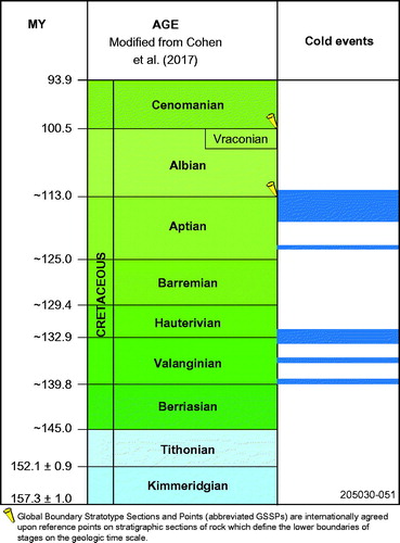
the early, middle and late Valanginian, the latter appearing to have extended into the Hauterivian, although how far is not clear;
early Aptian, following the OAE 1a; and
mid–late Aptian into the earliest Albian, although lacking glacial indicators, this appears to be a significant and relatively long-lived event.
The global data for the Valanginian () suggest that cold temperatures at high latitudes may have persisted for most of the interval with significantly colder temperatures in the early, middle and late parts of the stage, the latter temperature decrease lingering on into the Hauterivian.
The Livingston Glaciation probably occurred during the middle Valanginian and the persistence of ice-rafted boulders and diamictite lenses in the remainder of the Cadna-owie Formation are probably related to the cold conditions in the late Valanginian–Hauterivian (). For glacial ice to have formed in the middle Valanginian would mean that temperatures were low enough during the summer season for snow not to melt and to build up thick enough to form ice. It is quite possible that temperatures, low enough to allow for the persistence of glaciers and/or winter freezing, continued through most of the Hauterivian. Studies of the distribution of dropstones in the succession (Alley & Frakes, Citation2003; Frakes et al., Citation1995) indicate that glaciers might have been widespread around the southern to southwestern margin of the Eromanga Basin.
Figure 39. Global cold temperatures set against the stratigraphy of the southern Eromanga Basin. The blue arrows show the stratigraphic distribution of dropstones in the Early Cretaceous strata in the southern Eromanga Basin.
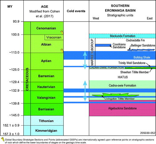
The early Aptian age we obtain for the Sheehan Glaciation indicates that this glacial event may be correlative with the cold snap in the early (but not earliest) Aptian recognised by other workers as following the OAE 1a event. This would imply that the Sheehan Tillite Member is slightly younger than we interpreted, but still within the palynological ages we obtained. The presence of ice-rafted boulders through most of the early to middle Aptian Marree Subgroup (Bulldog Shale) strongly suggests cold temperatures, allowing for the persistence of glacial ice and/or winter freezing during the interval. Thus, cold temperatures may have continued (perhaps sporadically) from early Aptian through to late Aptian at high latitudes (greater than 70° S).
An enigmatic diamictite/tillite and boulder bed at two sites, the presence of glendonite crystals in the late Aptian to early Albian Marree Subgroup (Bulldog Shale) and the boulders with glacial characteristics in the Bellinger Sandstone at Mt Yerila probably formed during the cold conditions recognised by many workers in the late Aptian to early Albian (see above). This implies that cold conditions, perhaps cold enough to form limited glaciers, persisted into the late Aptian and possibly the earliest Albian(?) at high latitudes (still around 70°S).
The pronounced cold event in the late Aptian recognised in the global data is not significant in the southern Eromanga Basin likely owing to the continued movement of the Australian plate during the Aptian into lower latitudes giving rise to a milder temperature regime, perhaps more periglacial than glacial.
A significant outcome of these climatic indicators is that global coolings, even moderate ones, have the potential to result in regional glaciations of variable scale.
Significance of the equilibrium line altitude in interpreting the degree of cooling during the Early Cretaceous glacial events
A theoretical line or zone on a glacier representing the altitude above which annual net snow accumulation can occur has been referred to as the Equilibrium Line Altitude (ELA, ) (Benn & Evans, Citation2010). In essence the line is equivalent to the firn line on modern glaciers above which glacier ice forms owing to net snow accumulation while melting occurs below (). The present ELA is close to or at sea level near the poles, intersecting sea level at ∼65°S latitude and rises to 4000–6000 m asl in the tropics (Broecker & Denton, Citation1990; Isbell et al., Citation2012). Thus, in high-latitude regions like Antarctica and Greenland, glaciers form at or near sea level (Miller, Bradley, & Andrews, Citation1975). Other factors including local and regional climate (in particular average temperature), precipitation, topography and latitude, influence the position of the ELA (Fujita, Citation2008). In the instance of the Scud Glacier (), which lies at ∼57°N latitude, the growth of ice is strongly influenced by topography (high relief) and high precipitation.
Figure 40. Concept of the ELA separating two glacial regimes. Modified from Isbell et al. (Citation2012).
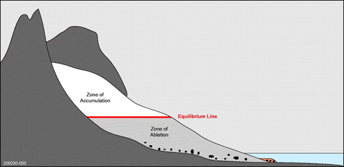
Figure 41. Firn line (ELA) on the Scud Glacier, Coast Mountains, northwestern British Columbia, Canada. (a) Dotted line is the approximate position of the firn line (ELA), up glacier from which there is ice growth and down glacier is ablation. Height of the mountains 2000–2800+ m asl and firn line ∼1100 m asl. Width of the valley at the ELA ∼1.3 km. Considerable thinning of the glacier down valley from the ELA is evident by the fresh moraine exposed along the mountain front on the right of the glacier. Photo taken in late autumn. (b) Vertical view of the ELA showing that it is a broad zone several hundred metres across rather than a distinct line. Ablation below the ELA is exposing medial moraines and crevasses.
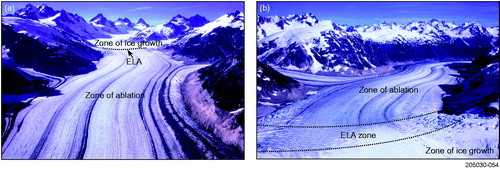
Thus, the factors that influence the local position and global distribution of the ELA provide insights into past glacial events (Fujita, Citation2008; Isbell et al., Citation2012). In addition to the above factors influencing the position of the ELA, pCO2 and carbon and oxygen isotope fluctuations during the late Paleozoic (Carboniferous to Permian) indicate that greenhouse gases were also a major control on climatic changes and therefore on the position of the ELA (Buggisch, Wang, Alekseev, & Joachimski, Citation2011; Frank, Birgenheier, Montañez, Fielding, & Rygel, Citation2008; Isbell et al., Citation2012; Montañez et al., Citation2007; Royer, Citation2006).
Global climatic changes will also result in a latitude-dependent rise away from the poles in the position of the ELA; cooling will lower the ELA and warming will cause a rise in the ELA globally (; Isbell et al., Citation2012). Thus, glaciers can form at any time as long as the topography rises above the local ELA and climate permits.
Figure 42. Left: rise in the ELA towards the Equator for the last glacial maximum and the present. Right: global change in the ELA during the last glacial maximum and minimum. Diagrams modified from Isbell et al. (Citation2012).
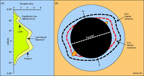
It can be assumed that if the ELA could be determined at a site during the geological past and other factors such as paleolatitude, paleoclimate, CO2 levels and paleotopography are known, then the nature of the glacier and intensity of glaciation at any site at any time can be reconstructed.
As shown earlier during the middle Valanginian and the early Aptian, the Livingston Tillite and Sheehan Tillite members were deposited in a shallow marine setting and the area was at very high latitude (70–80°S). Topographic relief during the Livingston and Sheehan glaciations appears to have been relatively low although considerable erosion is likely to have occurred since then.
Based on the above it can be concluded that during both glaciations ELAs were at sea level similar to current polar areas. Conditions are interpreted to have been very cold and that relief-enhanced precipitation was not a significant factor in the growth of the glaciers. If ELAs were at sea level, then local sea ice may also have formed seasonally.
We have provided some evidence earlier for another glacial event in the late Aptian to early Albian at a time when CO2 levels were low (Barral et al., Citation2017) and a prolonged global cooling occurred (see above). At this time the southern Eromanga Basin lay at 60–70°S, which is approximately the latitude at which the current ELA starts to rise above sea level (). Some of the glacigene sediments are associated with marine sediments suggesting that the ELA was at or near sea level, and, given the lack of significant topographic relief, conditions may still have been very cold. Alternatively, the fragmentary evidence for this glacial event in the southern Eromanga Basin could imply that glacial conditions were quite limited, this being the result of the Australian plate being further north at this stage.
The presence of dropstones with glacial characteristics in the early and late Valanginian, Hauterivian and Aptian sediments of the southern Eromanga Basin is intriguing. Isbell et al. (Citation2012) interpreted the presence of dropstones in late Paleozoic sediments as evidence of the ELA being at or near sea level, allowing glaciers to reach the sea and to shed icebergs thus rafting boulders out into the sea. The authors acknowledge, however, that ice blocks could have been carried by meltwater streams down to the sea and thus have been the transport medium for the dropstones. Even so the ELA was probably pretty close to sea level.
As we have suggested the topographic relief in the current northern Flinders Ranges during the Early Cretaceous was subdued. The association of the dropstones with marine sediments fringing the ranges in an area of low relief and at high latitude strongly suggests that ELA was at or near sea level implying very cold temperatures prevailed for some of the time.
Our palynological dating and analysis of the nonglacial sediments, albeit some bearing dropstones, provides evidence of milder conditions during the interval. Common fossil taxa occurring in the Early Cretaceous palynological assemblages are from coniferous plants along with understory types such as treeferns, ferns, clubmosses and peat mosses. Together these are indicative of cool moist conditions, probably in an open sub tundra-like setting, similar to the modern taiga in northern North America. Given that these pollen and spore-bearing sediments are interbedded with the glacigene sediments we interpret the climate for the Valanginian through to Aptian to be periods of glacial and periglacial climate alternating with milder conditions.
Table 1. List of key outcrop sites and drill holes shown in and referred to in the text.
Acknowledgements
Many people have given freely of their advice out in the field, about laboratory and dating procedures, and on stratigraphy of the Eromanga Basin and paleoclimatic changes during the Early Cretaceous. Their names will be acknowledged in much larger Geological Survey of South Australia Bulletin on the details of the stratigraphy of the area, sedimentology of the facies, sea level and paleoclimatic changes, along with all our procedures and results. However, a number of people have greatly assisted us with this aspect of our research, although what we express are our own views: we greatly appreciate the advice of Dr S. M. Hill for his support and comments on the text, Dr C. Hannaford who gave freely of her knowledge of Early Cretaceous dinoflagellates, Mr M. J. Sheard for his contribution in the field during the early part of this research, Dr D. E. Sweet for his comments on our quartz grain micromorphological interpretations, Dr J. E. Greenfield for providing us with information on the NSW part of the Eromanga Basin and for his comments on the text, Ms P. Aagard for finding sometimes obscure publications for us on Cretaceous paleoclimate and Ms Z. French of MER for her generous assistance in production of our images. We are also grateful for the comments made by our two referees Jane Francis and Elinor Alexander. NFA extends enormous thanks to co-author Steve Hore, whose contribution in basement geology and detrital zircon and monazite dating brought a new light to this research. We wish to give great thanks to the Sheehan family, Moolawatana Station, for their marvellous hospitality over the years and for their advice on the quickest way to get around the ranges.
Correction Statement
This article has been republished with minor changes. These changes do not impact the academic content of the article.
References
- Alexander, E. M., & Cotton, T. B. (2006). Chapter 1: Introduction. In T. B. Cotton, M. F. Scardigno & J. E. Hibburt (Eds.) The petroleum geology of South Australia, Vol. 2: Eromanga Basin. 2nd edition. Adelaide SA, Australia: South Australia, Department of Primary Industries and Resources. Petroleum Geology of South Australia Series.
- Alexander, E. M., Sansome, A., & Cotton, T. B. (2006). Chapter 5: Lithostratigraphy and environments of deposition. In T. B. Cotton, M. F. Scardigno & J. E. Hibburt (Eds.) The petroleum geology of South Australia, Vol. 2: Eromanga Basin. 2nd edition. Adelaide SA, Australia: South Australia, Department of Primary Industries and Resources. Petroleum Geology of South Australia Series.
- Alley, N. F., & Lemon, N. M. (1988). Evidence of earliest Cretaceous (Neocomian) marine influence, northern Flinders Ranges. South Australia. Geological Survey Quarterly Geological Notes, 106, 2–7.
- Alley, N. F., & Frakes, L. A. (2003). First known Cretaceous glaciation: Livingston Tillite Member of the Cadna-owie Formation, South Australia. Australian Journal of Earth Sciences, 50(2), 139–144. doi:10.1046/j.1440-0952.2003.00984.x
- Alley, N. F., & White, M. R. (1996). Chapter 6. Dating and correlating Eromanga Basin sediments. In E. M. Alexander & J. E. Hibburt (Eds.) The Petroleum Geology of South Australia. Volume 2: Eromanga Basin (pp. 87–100). Adelaide SA, Australia: South Australia Department of Mines and Energy. Report Book 96/20.
- Alley, N. F., Frakes, L. A., Sheard, M. J., & Gray, D. (2011). Unravelling Early Cretaceous glacial events in the southern Eromanga Basin: Evidence from the Cadna-owie Formation and Bulldog Shale. In C. J. Forbes (Ed.), 6th Sprigg Symposium: Unravelling the northern Flinders ranges and beyond. Geological Society of Australia Abstracts 100, 1–4. Sydney NSW: Geological Society of Australia.
- Alley, N. F., White, M. R., Price, P. L., & Wood, G. R. (2006). Chapter 6: Dating and correlating Eromanga Basin sediments. In T. B. Cotton, M. F. Scardigno & J. E. Hibburt (Eds.) The petroleum geology of South Australia, Vol. 2: Eromanga Basin. 2nd edition. Adelaide SA, Australia: South Australia, Department of Primary Industries and Resources. Petroleum Geology of South Australia Series.
- Arbreu, V. S., & Anderson, J. B. (1998). Glacial eustasy during the Cenozoic: Sequence stratigraphic implications. American Association of Petroleum Geologists Bulletin, 82 (7), 1385–1400. doi:10.1306/1d9bca89-172d-11d7-8645000102c1865d
- Arbreu, V. S., Hardenbol, J., Haddad, G. A., Baum, G. R., Droxler, A. W., & Vail, P. R. (1998). Oxygen Isotope Synthesis: A Cretaceous Ice-House? Tulsa, OK: SEPM Special Publication, No. 60.
- Baillie, P. W., Powell, C. M., Li, Z. X., & Ryan, A. M. (1994). The tectonic framework of Western Australia’s Neoproterozoic to Recent sedimentary basins. In P. G. Purcell & R. R. Purcell (Eds.), Sedimentary basins of Western Australia, Proceedings of the Petroleum Exploration Society of Australia Symposium, Perth, 1994 (pp. 45–62). Perth, WA: PESA.
- Barral, A., Gomez, B., Legendre, S., & Lécuyer, C. (2017). Evolution of the carbon isotope composition of atmospheric CO2 throughout the Cretaceous. Palaeogeography, Palaeoclimatology, Palaeoecology, 471, 40–47. doi:10.1016/j.palaeo.2017.01.034
- Benn, D. I., & Evans, D. J. A. (2010). Glaciers and Glaciation (2nd Ed.). Oxon, UK: Hodder Education.
- Bottini, C., & Erba, E. (2018). Mid-Cretaceous paleoenvironmental changes in the western Tethys. Climate of the past Discussions, 34, 1–23. doi:10.5194/cp-14-1147-2018
- Bottini, C., Erba, E., Tiraboschi, D., Jenkyns, H. C., Schouten, S., & Sinninghe Damste, J. S. (2015). Climate variability and ocean fertility during the Aptian Stage. Climate of the Past, 11(3), 383–402. doi:10.5194/cp-11-383-2015
- Broecker, W. S., & Denton, G. H. (1990). What drives glacial cycles?. Scientific American, 262(1), 48–56. doi:10.1038/scientificamerican0190-48
- Broster, B. E., & Hicock, S. R. (1985). Multiple flow and support mechanisms and the development of inverse grading in a subaquatic glacigenic debris flow. Sedimentology, 32(5), 645–657. doi:10.1111/j.1365-3091.1985.tb00479.x
- Broadbridge, L. A. (1994). Palynological processing techniques employed in the Department of Mines and Energy, South Australia. South Australia: Department of Mines and Energy, Report Book, 93/28.
- Brown, H. Y. L. (1894). Report of the Government Geologist on the country in the neighbourhood of Lake Eyre. South Australia Parliamentary Papers, 141.
- Buggisch, W., Wang, X., Alekseev, A. S., & Joachimski, M. M. (2011). Carboniferous–Permian carbon isotope stratigraphy of successions from China (Yangtze platform), USA (Kansas) and Russia (Moscow Basin and Urals). Palaeogeography, Palaeoclimatology, Palaeoecology, 301(1–4), 18–38. doi:10.1016/j.palaeo.2010.12.015
- Callen, R. A. (1972). Frome embayment stratigraphic drilling project: Preliminary report on South Australian Department of Mines Wooltana No. 1, Yalkalpo No. 1 and Wertaloona No. 1 stratigraphic bores (Report Book No. 72/160, GS No. 4926, DM No. 384/72). Adelaide SA: Department of Mines South Australia.
- Cohen, K. M., Finney, K. M., Gibbard, P. L., & Fan, J.-X. (2017). The International Commission on Stratigraphy, International Chronostratigraphic Chart. Episodes, 36, 199–204.
- David, T. W. E. (1906). Conditions of climate at various geological epochs. Paper presented at C.R. International Geological Congress, Mexico City, Mexico, 463–464.
- David, T. W. E., & Howchin, W. (1923). Glaciation in central Australia. Australian Association for the Advancement of Science, 16, 74.
- Ditchfield, P. W. (1997). High northern palaeolatitude Jurassic–Cretaceous palaeotemperature variation: New data from King Karls Land, Svalbard. Palaeogeography, Palaeoclimatology, Palaeocology, 130(1–4), 163–175. doi:10.1016/S0031-0182(96)00054-5
- Ditchfield, P. W., Marshall, J. D., & Pirrie, D. (1994). High latitude palaeotemperature variation: New data from the Tithonian to Eocene of James Ross Island, Antarctica. Palaeogeography, Palaeoclimatology, Palaeocology, 107(1–2), 79–101. doi:10.1016/0031-0182(94)90166-X
- Donnadieu, Y., Dromart, G., Goddéris, Y., Pucéat, E., Brigaud, B., Dera, G., … Olivier, N. (2011). A mechanism for brief glacial episodes in the Mesozoic greenhouse. Paleoceanography, 26, 1–10. doi:10.1029/2010PA002100
- Dumitrescu, M., Brassell, S. C., Schouten, S., Hopmans, E. C., & Sinninghe Damsté, J. S. (2006). Instability in tropical Pacific sea-surface temperatures during the early Aptian. Geology, 34(10), 833–866. doi:10.1130/G22882.1
- Elburg, M. A., Bons, P. D., Foden, J., & Brugger, J. (2003). A newly defined Late Ordovician magmatic-thermal event in the Mt Painter Province, northern Flinders Ranges, South Australia. Australian Journal of Earth Sciences, 50(4), 611–631. doi:10.1046/j.1440-0952.2003.01016.x
- Erba, E., Bartolini, A., & Larson, R. L. (2004). Valanginian Weissert oceanic anoxic event. Geology, 32(2), 149–152. doi:10.1130/G20008.1
- Etheridge, L. T., McMinn, A., Smyth, M., Walsh, I. L., & Davies, B. (1986). Eromanga Basin petroleum drillhole (DM Lake Stewart DDH1). Quarterly Geological Notes of the Geological Survey of New South Wales, 62, 16–30.
- Evenson, E. B., Dreimanis, A., & Newsome, J. W. (1977). Subaquatic flow tills: a new interpretation for the genesis of some laminated till deposits. Boreas, 6(2), 115–133. doi:10.1111/j.1502-3885.1977.tb00341.x
- Eyles, N., & Eyles, C. H. (1992). Glacial depositional systems. In R. G. Walker & N. P. James (Eds.), Facies Models. Response to sea level change (pp. 73–100). St Johns, NL: Geological Association of Canada.
- Fernández Mendiola, P. A., Mendioca, J., Owen, H. G., Hernández, S., Millan, M. I., & Garcia-Mondejar, J. (2013). Black shales of the early and late Aptian (Bilbao, Spain): C-isotopes and TOC. Geotemas, 13, 80–83.
- Frakes, L. A., & Francis, J. E. (1988). A guide to the Phanerozoic cold polar climates from high-latitude ice-rafting in the Cretaceous. Nature, 333(6173), 547–549. doi:10.1038/333547a0
- Frakes, L. A., & Francis, J. E. (1990). Cretaceous palaeoclimates. In R. N. Ginsburg & B. Beaudoin (Eds.), Cretaceous Resources, Events and Rhythyms (pp. 373–387). Dordrecht, The Netherlands: Kluwer Academic Publishers.
- Frakes, L. A., & Krassay, A. A. (1992). Discovery of probable ice-rafting in the Late Mesozoic of the Northern Territory and Queensland. Australian Journal of Earth Sciences, 39(1), 115–119. doi:10.1080/08120099208728006
- Frakes, L. A., Alley, N. F., & Deynoux, M. (1995). Early Cretaceous ice rafting and climatic zonation in Australia. International Geology Review, 37(7), 567–583. doi:10.1080/00206819509465419
- Frank, T. D., Birgenheier, L. P., Montañez, I. P., Fielding, C. R., & Rygel, M. C. (2008). Late Paleozoic climate dynamics revealed by comparison of ice-proximal stratigraphic and ice-distal isotopic records. In C. R Fielding, T. D. Frank & J. L. Isbell (Eds.), Resolving the Late Paleozoic Ice Age in Time and Space (pp. 331–342). Boulder, CO: Geological Society of America Special Paper, 441.
- Fujita, K. (2008). Effect of precipitation seasonality on climatic sensitivity of glacier mass balance. Earth and Planetary Science Letters, 276(1–2), 14–19. doi:10.1016/j.epsl.2008.08.028
- Galloway, J. M., Tullius, D. N., Evenchick, C. A., Swindles, G. T., Hadlari, T., & Embry, A. (2015). Early Cretaceous vegetation and climate change at high latitude: Palynological evidence from Isachsen Formation, Arctic Canada. Cretaceous Research, 56, 399–420. doi:10.1016/j.cretres.2015.04.002
- Gorter, J. D. (1994). Sequence stratigraphy and the depositional history of the Murta Member (upper Hooray Sandstone), southeastern Eromanga Basin, Australia: implications for the development of source and reservoir facies. APEA Journal, 34 (1), 644–673. doi:10.1071/AJ93049
- Grasby, S. E., McCune, G. E., Beauchamp, B., & Galloway, J. M. (2017). Lower Cretaceous cold snaps led to widespread glendonite occurrences in the Sverdrup Basin, Canadian High Arctic. Geological Society of America Bulletin, 129 (7–8), 771–787. doi:10.1130/B31600.1
- Gradstein, F. M., Agterberg, F. P., Ogg, J. G., Hardenbol, J., van Veen, P., Thierry, T., & Huang, Z. (1994). A Mesozoic time scale. Journal of Geophysical Research, 99(12), 51–74. doi:10.1029/94JB01889
- Gradstein, F. M., Ogg, J. G., & Smith, A. G. (Eds.) (2005). A geologic time scale 2004. Cambridge UK: Cambridge University Press. doi:10.1017/CBO9780511536045
- Greenfield, J. E., Gilmore, P. J., & Mills, K. J. (compilers) (2010). Explanatory notes for the Koonenberry Belt geological maps. Geological Survey of New South Wales, Bulletin, 35, 498p.
- Gröcke, D. R., Price, G. D., Robinson, S. A., Baraboshkin, E. Y., Mutterlose, J., & Ruffell, A. (2005). The Upper Valanginian (Early Cretaceous) positive carbon-isotope event recorded in terrestrial plants. Earth and Planetary Science Letters, 240, 495–509. doi:10.1016/j.epsl.2005.09.001
- Hay, W. H. (2008). Evolving ideas about the Cretaceous climate and ocean circulation. Cretaceous Research, 29(5–6), 725–753. doi:10.1016/j.cretres.2008.05.025
- Helby, R., Morgan, R., & Partridge, A. D. (1987). A palynological zonation of the Australian Mesozoic. Sydney NSW: Memoir of the Association of Australasian Palaeontologists, 4, 94p.
- Herrle, J. O., Schröder-Adams, C. J., Davis, W., Pugh, A. T., Galloway, J. M., & Fath, J. (2015). Mid-Cretaceous High Arctic stratigraphy, climate, and oceanic anoxic events. Geology, 43(5), 403–406. doi:10.1130/G36439.1
- Hicock, S. R., Dreimanis, A., & Broster, B. E. (1981). Submarine flow tills at Victoria, British Columbia. Canadian Journal of Earth Sciences, 18(1), 71–80. doi:10.1139/e81-006
- Hill, S. M., & Hore, S. B. (2011). Key insights into range-front mineral system expression and evolution from regolith and long-term landscape history, NE Flinders Ranges. MESA Journal, 63, 20–31.
- Hochuli, P. A., Menegatti, A. P., Weissert, H., Riva, A., Erba, E., & Premoli Silva, I. (1999). Episodes of high productivity and cooling in the early Aptian Alpine Tethys. Geology, 27(7), 657–660. doi:10.1130/0091-7613(1999)027<0657:EOHPAC
- Hore, S. B., & Hill, S. M. (2009). Palaeoredox fronts: setting and associated alteration exposed within a key section for understanding uranium mineralisation at the Four Mile West deposit. MESA Journal, 55, 34–39.
- Hore, S. B., Hill, S. M., & Alley, N. F. (2020). Early Cretaceous glacial environment and paleosurface evolution within the Mount Painter Inlier area, northern Flinders Ranges. Australian Journal of Earth Sciences 67(8), 1117–1160. https://doi.org/10.1080/08120099.2020.1730963
- Howchin, W. (1928). The building of Australia and the succession of life, Part 2 (pp. 287–291). London, UK: British Science Guild.
- Hu, X., Jansa, L., & Sarti, M. (2005). Mid-Cretaceous oceanic red beds in the Umbria-Marche Basin, central Italy: Constraints on paleoceanography and paleoclimate. Palaeogeography, Palaeoclimatology, Palaeoecology, 233(3–4), 163–186. doi:10.1016/j.palaeo.2005.10.003
- Huang, C. M., Retallack, G. J., & Wang, C. S. (2012). Early Cretaceous atmospheric pCO2 levels recorded from pedogenic carbonates in China. Cretaceous Research, 33(1), 42–49. doi:10.1016/j.cretres.2011.08.001
- Huber, B. T., Hoddell, D. A., & Hamilton, C. P. (1995). Mid- to late Cretaceous climate of the southern high latitudes: stable isotopic evidence for minimal equator-to-pole thermal gradients. Geological Society of America Bulletin, 107(10), 1164–1191. > 2.3.co;2 doi:10.1130/0016-7606(1995)107<1164:mlccot
- Isbell, J. L., Henry, L. C., Gulbranson, E. L., Limarino, C. O., Fraiser, M. L., Koch, Z. J., … Dineen, A. A. (2012). Glacial paradoxes during the late Paleozoic ice age: Evaluating the equilibrium line altitude as a control on glaciation. Gondwana Research, 22(1), 1–19. doi:10.1016/j.gr.2011.11.005
- Jack, R. L. (1915). Country south of the Musgrave Ranges. Geological Survey of South Australia Bulletin, 5, 37–53.
- Jahren, A. H., Arens, N. C., Sarmiento, G., Guerrero, J., & Amundson, R. (2001). Terrestrial record of methane hydrate dissociation in the Early Cretaceous. Geology, 29(2), 159–162. doi:10.1130/0091-7613(2001)029<0159:TROMHD
- Jansen, J. H. F., Woensdregt, C. R., Kooistra, M. J., & van der Gaast, S. J. (1987). Ikaite pseudomorphs in the Zaire deep-sea fan: An intermediate between calcite and porous calcite. Geology, 15(3), 245–248. > 2.0.CO;2 doi:10.1130/0091-7613(1987)15 < 245:IPITZD
- Jenkyns, H. C., Schouten-Huibers, L., Schouten, S., & Sinninghe Damsté, J. S. (2012). Warm Middle Jurassic–Early Cretaceous high-latitude sea-surface temperatures from the Southern Ocean. Climate of the Past, 8(1), 215–226. doi:10.5194/cp-8-215-2012
- Jones, C. E., & Jenkyns, H. C. (2001). Seawater strontium isotopes, oceanic events, and seafloor hydrothermal activity in the Jurassic and Cretaceous. American Journal of Science, 301(2), 112–149. doi:10.2475/ajs.301.2.112
- de Jong, M. G. G., & Rappol, M. (1983). Ice-marginal debris-flow deposits in western Allgäu, southern Germany. Boreas, 12(1), 57–70. doi:10.1111/j.1502-3885.1983.tb00360
- Keller, C. E., Hochuli, P. A., Weissert, H., Bernasconi, S. M., Giorgioni, M., & Garcia, T. I. (2011). A volcanically induced warming and floral change preceded the onset of the OEA1a (Early Cretaceous). Palaeogeography, Palaeoclimatology, Palaeoecology, 305(1–4), 43–49. doi:10.1016/j.palaeo.2011.02.011
- Kemper, E. (1983). Über Kalt- und Warmzeiten der Unterkreide. Zitteliana, 10, 359–369.
- Kemper, E. (1987). Das Klima der Kreide-Zeit. Geologische Jahrbuch, 96, 399.
- Kemper, E., & Schmitz, H. H. (1975). Stellate nodules from the Upper Deer Bay Formation (Valanginian) of Arctic Canada. Geological Survey of Canada Paper, 75-1C, 109–119. doi:10.4095/103040
- Kemper, E., & Schmitz, H. H. (1981). Glendonite-Indikatoren des polarmarinen Ablagerungmilieus. Geologische Rundschau, 70(2), 759–773. doi:10.1007/BF01822149
- Kessels, K., Mutterlose, J., & Michalzik, D. (2006). Early Cretaceous (Valanginian–Hauterivian) calcareous nannofossils and isotopes of the northern Hemisphere: Proxies for the understanding of Cretaceous palaeoclimate. Lethaia, 39(2), 157–172. doi:10.1080/00241160600763925
- Krieg, G. W., Alexander, E. M., & Rogers, P. A. (1995). Jurassic–Cretaceous Epicratonic Basins. Eromanga Basin. In J. F. Drexel, & W. V. Preiss (Eds.). The geology of South Australia. Volume 2. The Phanerozoic. South Australia (pp. 101–124). Adelaide SA: Department of Mines and Energy, Bulletin, 54.
- Kuhnt, W., Holbourn, A., & Moullade, M. (2011). Transient global cooling at the onset of the early Aptian oceanic anoxic event (OAE) 1a. Geology, 39(4), 323–326. doi:10.1130/G31554.1
- Ladant, J.-B., & Donnadieu, Y. (2016). Palaeogeographic regulation of glacial events during the Cretaceous supergreenhouse. Nature Communications, 7(12771), 1–9. doi:10.1038/ncomms12771
- Larson, G. J., Menzies, J., Lawson, D. E., Evenson, E. B., & Hopkins, N. R. (2016). Macro- and micro-sedimentology of a modern melt-out till – Matanuska Glacier, Alaska, U.S.A. Boreas, 45 (2), 235–251. doi:10.1111/bor.12149
- Larson, R. L., & Erba, E. (1999). Onset of mid-Cretaceous greenhouse in the Barremian–Aptian: Igneous events and the biological, sedimentary and geochemical response. Paleoceanography, 14(6), 663–678. doi:10.1029/1999PA900040
- Lemon, N. M. (1988). Tidal influences in the marginal Eromanga Basin. Quarterly Geological Notes, 105, 7–11. Adelaide SA: Geological Survey of South Australia.
- Lorenzen, J., Kuhnt, W., Holbourn, A., Flögel, S., Moullade, M., & Tronchetti, G. A. (2013). A new sediment core from the Bedoulian (Lower Aptian) stratotype at Roquefort-La Bédoule, SE France. Cretaceous Research, 39, 6–16. doi:10.1016/j.cretres.2012.03.019
- de Lurio, J. L., & Frakes, L. A. (1999). Glendonites as a paleoenvironmental tool: implications for early Cretaceous high latitude climates in Australia. Geochimica et Cosmochimica Acta, 63 (7–8), 1039–1048. doi:10.1016/S0016-7037(99)00019-8
- Mahaney, W. C. (2002). Atlas of sand grain surface textures and applications (p. 237). Oxford, UK: Oxford University Press.
- Mahaney, W. C., Claridge, G., & Campbell, I. (1996). Microtextures on quartz grains in tills from Antarctica. Palaeogeography, Palaeoclimatology, Palaeoecology, 121(1–2), 89–103. doi:10.1016/0031-0182(95)00069-0
- Malinverno, A., Hildebrandt, J., Tominaga, M., & Channell, J. E. T. (2012). M-sequence geomagnetic polarity time scale (MHTC 12) that steadies global spreading rates and incorporates astrochronology constraints. Journal of Geophysical Research, 117, B06104. doi:10.1029/2012JB009260
- Martinez, M., Deconinck, J.-F., Pellenard, P., Reboulet, S., & Riquier, L. (2013). Astrochronology of the Valanginian Stage from reference sections (Vocontian Basin, France) and palaeoenvironmental implications for the Weissert Event. Palaeogeography, Palaeoclimatology, Palaeoecology, 376, 91–102. doi:10.1016/j.palaeo.2013.02.021
- Matthews, R. K., & Poore, R. Z. (1980). Tertiary δ18O record and glacio-eustatic sea-level fluctuations. Geology, 8(10), 501–504. doi:10.1130/0091-7613(1980)8<501:TORAGS
- Maurer, F., Buchem, F. S. P., Eberli, G. P., Pierson, B. J., Raven, M. J., Larsen, P.-H., … Vincent, B. (2009). Late Aptian long-lived glacio-eustatic lowstand recorded on the Arabian Plate. Terra Nova, 25, 87–94. doi:10.1111/ter.12009
- McAnena, A., Flogel, S., Hofmann, P., Herrle, J. O., Griesand, A., Pross, J., … Wagner, T. (2013). Atlantic cooling associated with marine biotic crisis during the mid-Cretaceous period. Nature Geoscience, 6(7), 558–651. doi:10.1038/ngeo1850
- McArthur, J. M., Mutterlose, J., Price, G. D., Rawson, P. F., Ruffell, A., & Thirlwall, M. F. (2004). Belemnites of Valanginian, Hauterivian and Barremian age: Sr-isotope stratigraphy, composition (87Sr/86Sr, δ18O, Na, Sr, Mg), and palaeo-oceanography. Palaeogeography, Palaeoclimatology, Palaeoecology, 203, 253–272. doi:10.1016/S0031-0182(03)00638-2
- McArthur, J. M., Janssen, N. M. M., Reboulet, S., Leng, M. J., Thirlwall, M. V., & Van de Schootbrugge, B. (2007). Palaeotemperatures, polar ice-volume, and isotope stratigraphy (Mg/Ca, δ18O, δ13C, 87Sr/86Sr): The Early Cretaceous (Berriasian, Valanginian, Hauterivian). Palaeogeography, Palaeoclimatology, Palaeoecology, 248(3–4), 391–430. doi:10.1016/j.palaeo.2006.12.015
- Méhay, S., Keller, C. E., Bernasconi, S. M., Weissert, H., Erba, E., Bottini, C., & Hochuli, P. A. (2009). A volcanic CO2 pulse triggered the Cretaceous Oceanic Anoxic Event 1a and a calcification crisis. Geology, 37, 819–822. doi:10.1130/G30100A.1
- Melinte, C. M., & Mutterlose, J. (2001). A Valanginian (Early Cretaceous) ‘boreal nannoplankton excursion’ in sections from Romania. Marine Micropalaeontology, 43(1–2), 1–25. doi:10.1016/S0377-8398(01)00022-6
- Miller, G. H., Bradley, R. S., & Andrews, J. T. (1975). The glaciations level and lowest equilibrium line altitude in the high Canadian Arctic: maps and climatic interpretation. Arctic and Alpine Research, 7(2), 155–168. doi:10.2307/1550318
- Montañez, I. P., Tabor, N. J., Niemeier, D., DiMichele, W. A., Frank, T. D., Fielding, C. R., … Rygel, M. C. (2007). CO2-forced climate and vegetative instability during late Paleozoic deglaciation. Science, 315, 87–91. doi:10.1126/science.1134207
- Morales, C., Rogov, M., Wierzbowski, H., Ershova, V., Suan, G., Adatte, T., … van de Scootbrugge, B. (2017). Glendonites track methane seepage in Mesozoic polar seas. Geology, 45(6), 503–506. doi:10.1130/G38967.1
- Morgan, R. (1980). Palynostratigraphy of the Australian Early and Middle Cretaceous. Sydney NSW, Australia: New South Wales Geological Survey, Memoir 18.
- Morton, J. G. G. (1982). The Mesozoic–Cainozoic stratigraphy and faunas of the Tipooburra–Milparinka area (unpublished MSc Thesis). Kensington NSW, Australia: University of New South Wales.
- Mutterlose, J., & Kessels, K. (2000). Early Cretaceous calcareous nannofossils from high latitudes: Implications for palaeobiogeography and palaeoclimate. Palaeogeography, Palaeoclimatology, Palaeoecology, 60, 347–372. doi:10.1016/S0031-0182(00)00082-1
- Newton, C. B. (1986). The Tintaburra oilfield. APEA Journal, 26 (1), 334–352. doi:10.1071/AJ85029
- O’Brien, C. L., Robinson, S. A., Pancost, R. D., Sinninghe Damste, J. S., Schouten, S., Lunt, D. J., … Wrobel, N. E. (2017). Cretaceous sea-surface temperature evolution: Constraints from TEX86 and planktonic foraminiferal oxygen isotopes. Earth-Science Reviews, 172, 224–247. doi:10.1016/j.earscirev.2017.07.012
- Papp, C. P., Cociuba, I., & Lazăr, D. F. (2013). Carbon and oxygen-isotope stratigraphy of the Early Cretaceous carbonate platform of Pădurea Craiului (Apuseni Mountains, Romania): A chemostratigraphic correlation and palaeoenvironmental tool. Applied Geochemistry, 32, 3–16. doi:10.1016/j.apgeochem.2012.09.005
- Parkin, L. W. (1956). Notes on the younger glacial remnants of northern South Australia. Royal Society of South Australia Transactions, 79, 149–151.
- Payne, J., Barovich, K., & Hand, M. (2006). Provenance of metasedimentary rocks in the northern Gawler Craton, Australia: Implications for Palaeoproterozoic reconstructions. Precambrian Research, 148(3–4), 275–291. doi:10.1016/j.precamres.2006.05.002
- Petromin, N. L. (1971a). SML 456. Camp Hill. Progress reports for the period 6/8/70 to 5/8/71. Adelaide SA: Primary Industries and Resources SA. Open File Envelope, No. 1568.
- Petromin, N. L. (1971b). SML 610. Camp Hill. Progress reports to licence expiry for the period 6/8/71 to 5/8/72. Adelaide SA: Primary Industries and Resources SA. Open File Envelope, No. 1734.
- Pielou, E. C. (1991). After the ice age: The return of life to glaciated North America. Chicago IL: University of Chicago Press.
- Podlaha, O. G., Mutterlose, J., & Veizer, J. (1998). Preservation of δ18O and δ13C in belemnite rostra from the Jurassic/Early Cretaceous successions. American Journal of Science, 298(4), 324–347. doi:10.2475/ajs.298.4.324
- Preiss, W. V. (Compiler) (1987). The Adelaide Geosyncline–late Proterozoic stratigraphy, sedimentation, palaeontology and tectonics. Adelaide SA, Australia: Geological Survey of South Australia, Bulletin 53.
- Price, G. D. (1999). The evidence and implications of polar ice during the Mesozoic. Earth-Science Reviews, 48(3), 183–210. doi:10.1016/S0012-8252(99)00048-3
- Price, G. D., & Mutterlose, J. (2004). Isotopic signals from Late Jurassic–Early Cretaceous (Volgian–Valanginian) sub-Arctic belemnites, Yatria River, western Siberia. Journal of the Geological Society of London, 161(6), 959–968. doi:10.1144/0016-764903-169
- Price, G. D., & Nunn, E. V. (2010). Valanginian isotope variation in glendonites and belemnites from Arctic Svalbard: Transient glacial temperatures during the Cretaceous greenhouse. Geology, 38(3), 251–254. doi:10.1130/G30593.1
- Price, G. D., & Passey, B. H. (2013). Dynamic polar climates in a greenhouse world: Evidence from clumped isotope thermometry of Early Cretaceous belemnites. Geology, 41(8), 923–926. doi:10.1130/G34484.1
- Price, G. D., Sellwood, B. W., & Pirrie, D. (1996). Middle–Late Cretaceous climate of the southern high latitudes: stable isotopic evidence for minimal equator-to-pole thermal gradients: discussion. Geological Society of America Bulletin, 108(9), 1192–1193. doi:10.1130/0016-7606(1996)108<1192:MLCCOT
- Price, P. L. (1997). Permian to Jurassic palynostratigraphic nomenclature of the Bowen and Surat Basins. In P. M. Green (Ed.), The Surat and Bowen Basins, south-east Queensland. Queensland Minerals and Energy Review Series (pp. 137–178). Brisbane QLD, Australia: Queensland Department of Mines and Energy.
- Price, P. L., Filatoff, J., Williams, A. J., Pickering, S. A., & Wood, G. R. (1985). Late Palaeozoic and Mesozoic palynostratigraphical units. CSR Oil and Gas Division, Palynology Facility Report. South Australia. Department of Primary Industries and Resources. Open File Envelope, 6846, 41–90. unpublished).
- Pucéat, E., Lécuyer, C., Sheppard, S. M. F., Dromart, G., Reboulet, S., & Grandjean, P. (2003). Thermal evolution of Cretaceous Tethyan marine waters inferred from oxygen isotope composition of fish tooth enamels. Paleoceanography, 18, 1–12. doi:10.1029/2002PA000823
- Purgstaller, B., Dietzel, M., Baldermann, A., & Mavromatis, V. (2017). Control of temperature and aqueous Mg2+/Ca2+ ratio on the (trans-) formation of ikaite. Geochimica et Cosmochimica Acta, 217, 128–143. doi:10.1016/j.gca.2017.08.016
- Reid, A., Payne, J., & Wade, B. (2006). A new geochronological capability for South Australia: U–Pb zircon dating via LA-ICPMS. MESA Journal, 42, 27–37.
- Rodríguez-López, J. P., Liesa, C. L., Pardo, G., Meléndez, N., Soria, A. R., & Skilling, I. (2016). Glacial dropstones in the western Tethys during the late Aptian–early Albian cold snap: Palaeoclimate and palaeogeographic implications for the mid-Cretaceous. Palaeogeography, Palaeoclimatology, Palaeoecology, 452, 11–27. doi:10.1016/j.palaeo.2016.04.004
- Rogers, P. A., & Freeman, P. J. (1996). Warrina South Australia.Sheet SH53-3 International Index. 1:250 000 Geological series-explanatory notes (p. 44). Mines and Energy South Australia.
- Rogov, M. A., Ershova, V. B., Shchepetova, E. V., Zakharov, V. A., Pokrovsky, B. G., & Khudoley, A. K. (2017). Earliest Cretaceous (late Berriasian) glendonites from Northeast Siberia, revise the timing of initiation of transient Early Cretaceous cooling in the high latitudes. Cretaceous Research, 71, 102–112. doi:10.1016/j.cretres.2016.11.011
- Royer, D. L. (2006). CO2-forced climate thresholds during the Phanerozoic. Geochimica et Cosmochimica Acta, 70(23), 5665–5675. doi:10.1016/j.gca.2005.11.031
- Sames, B., Wagreich, M., Wendler, J. E., Haq, B. U., Conrad, C. P., Melinte-Dobreniscu, M. C., … Zorina, S. O. (2016). Review: Short-term sea-level changes in a greenhouse world – A review from the Cretaceous. Palaeogeography, Palaeoclimatology, Palaeoecology, 441 (3), 393–341. doi:10.1016/j.palaeo.2015.10.045
- Sellwood, B. W., Price, G. D., & Valdes, P. J. (1994). Cooler estimates of Cretaceous temperatures. Nature, 370(6489), 453–455. doi:10.1038/370453a0
- Senior, B. R., Exon, N. F., & Burger, D. (1975). The Cadna-owie and Toolebuc formations in the Eromanga Basin, Queensland. Queensland Government Mining Journal, 76, 445–455.
- Sheard, M. J. (1991). Glendonites from the southern Eromanga Basin in South Australia: palaeoclimatic indicators for Cretaceous ice. Quarterly Geological Notes, 114, 17–23. Adelaide SA: Geological Survey of South Australia.
- Sheard, M. J. (2009). Explanatory Notes for CALLABONNA 1:250 000 Geological Map, sheet SH 54-6 (Report Book, 2009/01). Adelaide SA: South Australia Department of Primary Industries and Resources.
- Sheard, M. J., & Flint, R. B. (1992). Cretaceous wave-polished granite surfaces, northern Mount Babbage Inlier, South Australia. Quarterly Geological Notes, 122, 19–23. Adelaide SA: Geological Survey of South Australia.
- Sláma, J., & Košler, J. (2012). Effects of sampling and mineral separation on accuracy of detrital zircon studies. Geochemistry, Geophysics, Geosystems, 13, 5–17. doi:10.1029/2012GC004106
- Stoll, H. M., & Schrag, D. P. (1996). Evidence for glacial control of rapid sea level changes in the early Cretaceous. Science, 272(5269), 1771–1774. doi:10.1126/science.272.5269.1771
- Teale, G. S. (1979). Revision of nomenclature for Palaeozoic intrusives of the Mount Painter Province, South Australia. Royal Society of South Australia Transactions, 103, 95–100.
- Tejada, M. L. G., Suzuki, K., Kuroda, J., Coccioni, R., Mahoney, J. J., Ohkouchi, N., … Tatsumi, Y. (2009). Ontong Java Plateau eruption as a trigger for the early Aptian oceanic anoxic event. Geology, 37(9), 855–858. doi:10.1130/G25763A.1
- Veevers, J. J., Powell, C. M., & Roots, S. R. (1991). Review of seafloor spreading around Australia. 1, Synthesis of the patterns of spreading. Australian Journal of Earth Sciences, 38(4), 373–389. doi:10.1080/08120099108727979
- Vickers, M. L., Price, G. D., Jerrett, R. M., & Watkinson, M. (2016). Stratigraphic and geochemical expression of Barremian–Aptian global climate change in Arctic Svalbard. Geosphere, 12(5), 1594–1605. doi:10.1130/GES01344.1
- Wang, Y., Huang, C., Sun, B., Quan, C., Wu, J., & Lin, Z. (2014). Palaeo-CO2 variation trends and the Cretaceous greenhouse climate. Earth-Science Reviews, 129, 136–147. doi:10.1016/j.earscirev.2013.11.001
- Weissert, H., & Erba, E. (2004). Volcanism, CO2 and palaeoclimate: A Late Jurassic–Early Cretaceous carbon and oxygen isotope record. Journal of the Geological Society of London, 161, 695–702. doi:10.1144/0016-764903-087
- Wilkinson, I., & Riding, J. (2007). The Cretaceous greenhouse world. British Geological Survey, Earthwise, 24, 32–33.
- Woodard, G. D. (1955). The stratigraphic succession in the vicinity of Mt Babbage station, South Australia. Transactions of the Royal Society of South Australia, 78, 8–17.
- Woolnough, W. G. (1926). Preliminary notes on the occurrence of large erratic blocks probably of glacial origin, on the eastern escarpment of the Flinders Ranges, South Australia. Journal of the Australasian Advancement of Science, 17, 81–84.
- Woolnough, W. G., & David, T. W. E. (1926). Cretaceous glaciation in central Australia. Quarterly Journal Geological Society of London, 82(1–4), 332. doi:10.1144/GSL.JGS.1926.082.01-04.20
- Wopfner, H., Freytag, I. B., & Heath, G. R. (1968). Stratigraphy and facies of basal sediments, western Great Artesian Basin, South Australia (Report Book, 66/103). South Australia. Department of Mines.
- Wopfner, H., Freytag, I. B., & Heath, G. R. (1970). Basal Jurassic–Cretaceous rocks of the western Great Artesian Basin, South Australia: stratigraphy and environment. AAPG Bulletin, 54, 383–416.