
ABSTRACT
This article reports on one experimental case of interdisciplinary collaboration on a design and planning exercise across several scales – local through urban to regional – and sectors – private, public, scholarly, and interest groups. The case is a collaborative and interdisciplinary design charrette on sustainable urbanism for envisioning the future of the Greater Metropolitan Area of Florence in Italy. The experiment entailed the attempt to integrate complex urban conditions via the design charrette in order to create more healthy and sustainable cities. This collaborative work shows how conditions that are at times not addressed comprehensively nor holistically can be combined through doing applied research by design; where design is understood as a process of discovery and creation that results in synthesis. The article details the methodology applied, and provides an initial assessment on the process that the charrette employed. Moreover, it highlights some professional and policy implications of the effort. Finally, it provides a provisional assessment on learning outcomes and addresses opportunities to improve future exercises of this nature.
Introduction
One of the most pressing challenges to planning and design practice remains effective inter- and cross-disciplinary collaboration among sectors and across scales of intervention (Brenner Citation2019; Neuman and Zonneveld Citation2018; Perrone Citation2017). This is especially so as cities, along with urban and infrastructural projects, get bigger and more complex. While multi-disciplinary (aggregating individual disciplines without interactions among them) collaboration is commonplace, true inter-disciplinary (the spaces between disciplines) and cross-disciplinary (the links among disciplines) remain less explored than ‘merely’ multidisciplinary approaches. Thus, they are more experimental. All these circumstances point toward this being a pressing challenge to educators who prepare students of professional practice (Green Leigh et al. Citation2019; Frank and Silver Citation2018; Neuman Citation2016).
This article reports on one experimental case of interdisciplinary collaboration across several scales – local through urban to regional – and sectors – private, public, scholarly, and interest groups. It is the work of students of the Master of Architecture at the University of Westminster (UoW) and of the Master of Planning at the University of Florence (UniFi). They participated in a two-week long interdisciplinary and collaborative sustainable urban design charrette. They critically examined urban and regional design issues and opportunities for the greater Metropolitan Area of Florence, Italy.Footnote1 We further report briefly on the professional and policy implications of the students’ work, and provide a preliminary assessment on the process that the charrette employed in the conduct of its work. The latter includes a provisional assessment on learning outcomes. Based on this experience, we offer suggestions on how to improve future exercises of this nature. The emphasis of this article is on the pedagogy of an experimental design charrette.
The charrette, as an intensive yet short exploration into a set of place-specific issues and conflicts that uses design methods to analyse conditions and devise solutions, is well established in the planning and design professions (Walker and Seymour Citation2008; Lennertz and Lutnzenhiser Citation2006; Roggema Citation2014). These methods were adapted to the specific circumstances encountered in Florence. Importantly, this included the fact that in the year 2014, the Italian government adopted a law specifying eight new metropolitan governments situated institutionally and constitutionally between the local (municipal) and regional governments.Footnote2
Given the situation on the ground, including the governance novelty introduced by the new metropolitan government, we wanted to address a research question that responded to this context. The research question also addresses a very long standing debate in the planning profession about the status of the masterplan, alternatively called a comprehensive plan or general plan (Wildavsky Citation1973; Neuman Citation1998).
The research question and method
The research question is: To which extent is it possible to simulate in a multi-disciplinary design and planning studio the context, conditions and principles for the preparation for a spatial / general / master / comprehensive plan that addresses sustainability in the built environment with a holistic, multi-factor and multi-scalar approach? The context is complicated yet enriched because of the deep, 2000+ year history of agriculture and landscape transformation on the site, going back to Roman times. To the extent feasible in a two week project, the students attempted to integrate this complex history into their proposals. This research question is opposed to the more typically narrow focus on a single project, issue, hypothesis, or scale. Thus the focus is pedagogical, about teaching and learning applied professional practice, rather than typical academic research.
The pedagogical research method is explicitly exploratory, and employs an ‘N = 1’ approach, where the focus is on depth, not breadth (Mukhija Citation2010), to provisionally test the hypothesis whether this type of learning to prepare a design plan, can be approximated in a student studio setting. Based on our experience, a set of evaluation criteria is proposed, which would need to be tested more systematically in other settings in order to validate. We adopt this stance because, to arrive at sustainable planning and design solutions in a comprehensive sense, requires that a wide range of intersecting issues be dealt with simultaneously, rather than separately or individually as is often the case with academic research. In other words, the learning environment for the student is intentionally meant to mirror the demands and challenges of the real world in which the students will soon engage after completing their studies. These types of studio learning exercises on a local case trade by various adjectives around the world: service-based, practice-based, community-based, and so on.
The charrette
The Città Metropolitana di Firenze was established in the year 2015, and begun efforts to prepare its initial metropolitan strategic plan in 2017, the same year as the charrette reported here. The analyses, plans, and designs reported herein were prepared by the students that participated in the charrette. Their efforts were supported by the data and advice that was provided by several research units (University of Florence, City Council of Florence, Città Metropolitana di Firenze, Fondazione Michelucci), all of whom donated staff time and knowledge to this study. The interpretations and conclusions belong to the authors alone, and not to the students, governments and others that participated.
Nine University of Westminster Master of Architecture students along with nine University of Florence Master of Urban Planning students took part in the international and interdisciplinary workshop. Focusing on sustainable urbanism, the charrette was an intense, participative, collaborative, and inter-disciplinary design project which developed and analysed site-specific urban development solutions. The focus was on how to improve the environment, health, and well-being of a five-kilometer square area on the city’s northwestern metropolitan fringe using urban and regional design tools and principles.
Through lectures, site explorations, discussions, data analysis, and design, the charrette sought to apply a holistic approach to issues of development, transport, infrastructure, ecology, economics, and design, in order to create integrated solutions that put sustainability at the centre of urban design. The students interrogated practices of sustainable urbanism learned in the charrette by examining the extent to which they reframed existing planning and design practices in Florence regarding the urban / peri-urban interface.
This approach encouraged them to rethink the concept of sustainable urbanism so that issues of food security, biodiversity, health, and responsive housing practices were thought of simultaneously, alongside more traditional categories of energy, water, ecosystems, infrastructure, land use, and so on. Doing this enables the fashioning of proposals that transverse existing and future conditions instead of linear extrapolation of past tendencies that tends to reinforce prevailing practices rather than interrogate them (Magnaghi Citation2006; Paba and Perrone Citation2015).
The students were organized into five design groups for both the initial analysis phase of one week and the final design phase, also of one week. They collected data online, onsite, from professional reports and from scholarly research of others. Much of this was spatial in nature. Additionally, by applying a ‘SWOT’ analysis, they distilled Strengths, Weaknesses, Opportunities, and Threats of the area as one basis of their designs.
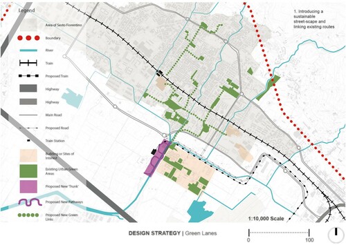
Three of the five student teams,Footnote3 each working under a team name of its own choice – Eco-chord, Organi[C]ity and Via Verde, for example – through different yet partly complementary approaches, explored a series of ways to concentrate activities around canals, cycle paths, parks, and transport hubs. Through the rehabilitation of some historical traces of the territory, in terms of landscape and uses (especially Roman era canals), their projects created opportunities for agriculture, wildlife, and recreational purposes. The student team Sesto Stiches improved the relationship between the residential area of Sesto with the neighbouring university campus on the project site. The team ScienceCity focused its project on the university campus as well. It proposed a denser university city with a series of facilities both for students and the community of Sesto, in order to take advantage of mutual synergies and better connect the two communities, currently separate. See the student groups’ final designs, .
Figure 1. Ecochord group design proposal.
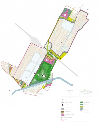
Figure 2. Via Verde group design proposal.
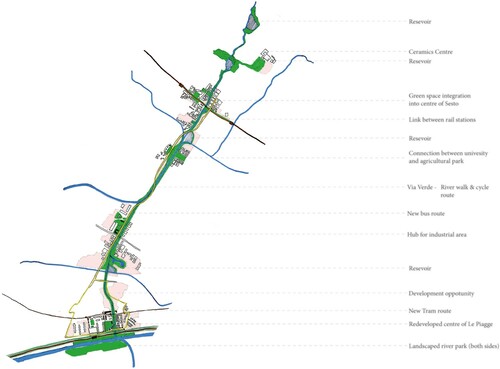
Figure 3. Organicity group design proposal.
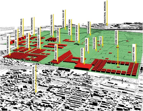
Figure 4. Science city group design proposal.
Figure 5. Sesto stiches group design proposal.
The context
Tuscany polycentric region
Tuscany has always been characterized by an interlinked network of cities that since the Middle Ages have constitute the backbone of its urban system. Although the city of Florence has played a major role, it was part of a more complex polynuclear region where several and distinct poles formed an interconnected urbanized galaxy. The hierarchy of the main centres has become less incisive and obvious, and with this has appeared an urban/rural divide. This brought a distribution and decentralization of functions and a more evenly dispersed distribution of population and employment density () (Magnaghi Citation2013; Burgalassi Citation2010; Paba et al. Citation2017; Agnoletti Citation2017).
Figure 6. The polycentric urban core of the central Tuscany.
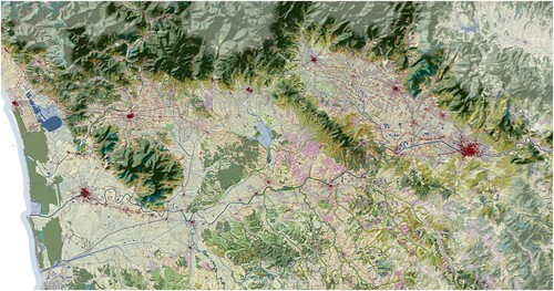
Polycentrism in central Tuscany is characterized mainly by three elements: a territorial extension that spilled outside of its historical centres, the presence of a multiplicity of poles of equivalent importance, and a complementary functionality of these poles and its network. This new dispersed urban form has the advantage of weighing on relatively small centres that are less likely to experience agglomeration diseconomies such as congestion, pollution, and a distorted real estate market ().
Figure 7. The study area in its metropolitan Florence context.
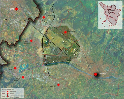
When the students focused on polycentrism in the outskirts of Florence, they discovered, based on the evidence provided by local experts, how the peri-urban area of the city has been changing over time in order to host the City of Florence’s expansion both in morphological and functional terms. This is particularly true in the western periphery of Florence, an area that is now object of different and to some extent contradictory development projects. These conditions offer a rich panoply for study and for design proposals.
The metropolitan area of Florence
In the Florence metro area, with a current population of one million, the countryside has suffered from fragmentation and lack of planning, thus becoming a residual and marginal realm. On the contrary, in any attempt to make this area play a stronger part of the region, the rural area has to play a fundamental role by which it can mend the fragmented and incoherent built environment. It has to be at the core of whatever project that interests the territory. This attempt to have the rural area become more central seemed to be at the core of all the projects presented for the area recently, with the exceptions of the most recent proposals that suggested, respectively, the extension of the airport runway and the installation of an incinerator. Both ideas were in contrast with the long-standing intention of realizing an agricultural park of regional relevance, able to combine a productive and a recreational function. Such ambiguity has caused a period of stagnation and planning inertia that did not allow any of these projects to see light.
The study area
The study area was chosen for the charrette because the complex challenges presented by these development project proposals prepared by others showcase the conflicts amongst them, and with the surrounding territory. Although the urbanization grew dramatically over the last decades of the past century, the territory, being fertile, has always hosted a system of farms and cottages around which some towns gradually expanded.
The project site (also referred to as study area) of twenty-five square kilometers was in the outskirts of northwest Florence, bordered by the airport, the Arno river, and the hills surrounding the Arno plain. The site is situated in the 7000 hectares of Il Parco delle Piana, which is planned to be a multifunctional agricultural park. If developed, it would reinforce the polycentric system of the metro area, becoming its main connective tissue.
Not urban, yet not properly rural either, the study area is placed between the city and the open countryside. It represents a space of transition and mediation. It is a buffer zone with a highly strategic role that cannot be underestimated. Among its potentials is as a green system of inter-urban connection that would enhance the interaction between the urban and the rural domains (Fanfani Citation2014, Citation2018). If this were to occur, then the peri-urban area might recover the complementary relationship between the two in terms of production and leisure, losing its current residual role.
On the other hand, if the planned agricultural park does not become developed, the students were asked to devise scenarios about the relationship between the city and its peri-urban surroundings with the specific aim of rebalancing their relationship. The teams answered to the challenge effectively delivering original design visions that, hopefully, might be of some inspiration for the future planning of this area.
The approach
This charrette was an intense and short term participative, collaborative, and interdisciplinary design project. The student teams analysed the territory and then developed prototype urban development solutions for specific sites in peri-urban Florence. They were asked to simultaneously address interconnected issues of ecology, development, economy, agriculture, transport and infrastructure by developing integrative analyses and solutions that were intended to improve health and well-being of humans, other species, ecological habitats and the overall metropolitan area.
The charrette used an integrated approach that analysed local conditions and practices of sustainable urbanism in the urbanized core of the Tuscan Region. The students investigated current practices of sustainable urbanism in Florence by examining the extent to which they reframe existing planning and design principles regarding the urban/peri-urban interface. At the outset, the professors and tutors promulgated to the students a perspective towards ‘co-evolutionary’ re-localization of information, matter and energy flows while fostering innovative ‘proximity’ economies as well as bottom-up social practices (Petit-Boix and Leipold Citation2018).
The project analyses and designs dealt with impacts stemming from the joint effects of climate change, globalization and urban growth. Key issues under study include multifunctional urban regeneration, multipurpose eco-corridors, sustainable peri-urban agriculture, local food production and consumption patterns, innovative grassroots housing practices, biodiversity, ecosystem services, mobility and water management. This extensive scope of complex and inter-related issues proved to be a significant challenge to all involved. At the same time, the students attempted to rise to this substantial challenge, as many were not from Florence and thus had little local knowledge. Moreover, few had experience in dealing with such a large and complex set of issues at multiple scales. This provided a separate challenge to the instructors and tutors in terms of constructing the most appropriate learning environment and fostering learning outcomes, discussed below.
The charrette was organized in two phases, in each of which were conducted site visits, field surveys, problem analysis and proposal preparation at different scales – regional, sub-regional, local. In addition, local stakeholders such as NGOs and municipalities, were engaged. The first phase analysed the entire metropolitan area and identified the sub-area in the northwest where to develop the sustainable urban design proposals with the most potential for positive impact on the greater Florence metropolitan area. The second phase consisted of the planning and design of the student groups’ local project areas of 1–2 square kilometers each.
The aspiration of the method employed in this charrette is that it was holistic, comprehensive, and integrative in ways that typical urban sustainability research and practice are not. Typically, a focus on energy, or transport, or water, or food security, or housing – or even two or a few of these in combination – at a single scale is not comprehensive and holistic. This project sought to include all strategic factors, as well as stakeholders, in an interactive, integrative, grassroots process that is multi-scalar and multi-disciplinary. The approach employed in this experiment enabled data and interests to be brought together and evaluated using consensual multi-variate criteria befitting the complexity of large urban projects. Thus, real world conditions were incorporated as much as possible given the tight time constraints, rather than selecting a more ‘manageable’ project with restricted conditions.
We hypothesized that this approach would partially fill an applied research-practice gap that could constitute the creation of new knowledge in the built environment disciplines, both in terms of pedagogy and in terms of research. In this sense, we in part equate design and applied research. Design as a process of discovery and creation that results in synthesis. Applied research as a process of discovery via observation and analysis that also results in creation, of new knowledge.
We emphasize partially because the interdisciplinary collaboration we refer to is two-fold. First, it is among the different disciplines of the students. As they are primarily architecture and planning students, interdisciplinary collaboration among themselves was limited, even as the post-graduate planning students came from a wide range of undergraduate disciplines. Second, the interdisciplinary collaboration is also among the students, academic staff and professionals from the Tuscan region. The academics and professionals were an interdisciplinary group: geology, hydrology, landscape, architecture, planning, engineering, history, geography and political science. The interactions among the students and the professionals was carried out in three ways. First, in short visits to the studio space where the students and academics conducted the charrette. Second, in a day-long site visit, where professionals, government bureaucrats, and politicians imparted their information and engaged in a question-answer discussion with the students and academics. Third, in the presentations of the students’ work – in progress and at conclusion – government officials and professionals interacted with the students as critics or reviewers of their analyses and design proposals. In these senses, the collaboration was partial, even as it was intensively problematized by the studio masters at the outset and revisited daily during the conduct of the charrette. This evolutionary approach to collaboration was thought to befit the experimental approach. We note that the professionals and officials were ‘pre-screened’ by local academic staff to be supportive of the experimental, collaborative approach.
This process and the outputs, five partial plans for one kilometer square project areas in a subregion of the Florence metro area, contrasted with classic master plan methods where a single comprehensive plan was prepared all at once (over a period of time) for an entire jurisdiction. Our approach posited an emergent analysis and drawn plan-designs for smaller areas, which could support the actual development of the area, in addition to supporting the preparation of a master plan that was being contemplated by the new metropolitan government. Thus, these plans address polycentrism in a way that rural areas became somewhat more central to the territory.
By collaboration, we mean a process in which the participants (collaborators) work and dialogue together in a mutual and supportive way, with an open, learning-oriented attitude. The collaborators in this instance are the students, academic staff, professionals, and government officials. While this may sound idealistic in a ‘real world’ environment, in the simulation of such in this university design studio, it was made possible largely by the absence of the pressure of concrete interests. It was further enabled by the studio instructors, decades of experience in design exercises in both academic and professional settings, along with decades of experience in designing and managing multiparty negotiation and conflict resolution processes.
Following these interactive precepts that recognize that both design and applied research, each a form of learning and each a method of creation, place the notion and practice of design as central to learning. As such, the multi-disciplinary team (architects, landscape architects, urban designers, urban planners, engineers, ecologists, sociologists) spanning two universities and two nations tested innovative and exploratory research and learning hypotheses that sought to integrate complex urban conditions via design to create more healthy and sustainable cities.
In this context, we asked the students to consider the study area in the wider context, using a multi-scalar approach. Each team had to focus on a smaller area within the ‘cloud’, the term applied to the five-kilometer square (approximately 25 square kilometers) study area. By varying the scales at which they worked, this allowed the students to consider the relations among the scales, the different nature of problems as suggested by the perspectives of different scales, and, consequently, the different implications of the different design solutions that they suggested. They managed to test several design solutions, each according to the several scales under consideration. In so doing, they identified a hierarchy among the elements, and their inter-relations. While the classical urban design studio exercise implies a unidirectional change of scale, this time the students were asked to vary scales, passing from smaller to bigger scales and vice-versa.
The schedule
The charrette brought together students and professionals of diverse nationalities and disciplines. Based on the logic of laboratory work, the charrette had an interactive structure where different design solutions were continuously tested and discussed with the teaching staff and among the different groups. The feedback sessions, although brief, stimulated participation and allowed to discuss alternative solutions among the teams. All the teams worked collaboratively, with each member bringing something different to the process. The aim was to develop a collective co-creation of ideas that through a multidisciplinary exchange was able to produce proposals for the area. The experience provided the students with collaboration and communication skills that enabled them to engage with each other throughout the charrette.
DAY 1
The first day was fundamental in order to get preliminary information about the study area. Academic staff of the University of Florence, through a series of illustrated talks, built up the essential framework within which the design exercise would have taken place. Together with geomorphological and historical changes that interested the area over time, issues of governance and institutional reform alongside the succession of different, and to some extent contradictory, planning initiatives for the site, have been effectively portrayed providing the student with a rather rich background knowledge. The first site visit was through the historical centre of the City of Florence that, although outside of the study area, served to introduce the wider context, putting the project area in perspective both in historical and geographic terms.
DAY 2
A day-long site visit to the study area allowed us to explore properly the site making us understand both opportunities and challenges. Partly conducted by bicycle, partly by foot, and guided by teachers, local planners, and local politicians, we crossed the different realities that comprise the study area. This included the unexploited opportunity represented by the park, the self-contained and disconnected residential areas, the industrial site, and the university campus. The brainstorming session at the end of the day was useful to locate the visited areas on the map and to identify relations and disconnections between them.
DAY 3
In the hillside setting of the Fondazione Michelucci, overlooking Florence, the students, organized into their five teams, were each asked to analyse the entire area through the lens of a particular thematic layer that were identified as the result of an interactive workshop:
infrastructures
urban patterns
Agro-ecological networks and hydrogeological networks
borders and in-between areas
Socio-economic factors, including equity and accessibility
Each group was asked to draw a strategic sketch plan for the entire area that highlighted opportunities and weaknesses related to the thematic layer that they were assigned. Achieved that, the teams were re-grouped, with each member coming from a group that focused on a different theme before, so that everyone was finally represented in those that will be the definitive teams until the end of the charrette.
The new teams start working by sharing the results of the previous analysis, reaching now a fairly complete idea on the site. They were asked to reduce the scale and to develop two potential design areas for which they had to prepare another strategic sketch plan. Reducing the scale did not imply forgetting the wider context. Instead, they endeavoured to see site planning as a continuous exercise of ‘zooming in’ and ‘zooming out’ that had to be taken into account until the end. That is, throughout the charrette, they continuously considered multiple scales simultaneously.
DAY 4
Each team submitted two proposals for the design areas that answered the following criteria:
The study area must be an urban-rural interface and include portions of territory with different characters, that show the conflicts and/or contradictions that are evident in study area;
Choose a study area that provide the greatest opportunity to make positive contributions to the public and common good, that considers the geohistory of the territory;
The design area should include intersections between systems and infrastructures in order to ensure a good balance between ecosystem services and then to pursue sustainable urban metabolism.
Each proposal was assessed in the light of their relevance to the three preconditions set above. Once they had chosen their specific design areas, the teams started to draft proposals for them.
DAYS 5–6–7–8
Over the following days, the groups kept working under the supervision of tutors and teachers that through individual reviews and public discussions. The students continued to receive feedback on their work in progress until Tuesday evening of the second week, when each team presented their draft final proposal.
DAY 9
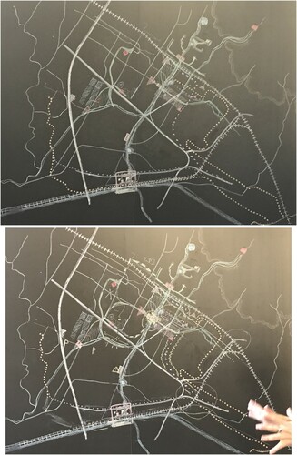
The morning was necessary to revise their draft final proposals on the basis of the feedback and criticism that each group received the day before. The afternoon was spent conducting a challenging exercise: the entire class worked together and tried to assemble all the five separate design areas (one by each team) into one a composite design for the entire site / study area. See (a,b). This interactive design exercise tested complementary design hypotheses, which generated lively debate. They were eventually able to adjust their five team proposals to create one overall scheme. Stimulating discussions ensued whenever the proposals highlighted apparent contradictions, but at end the five student teams reached an overall agreement, in some circumstances based on compromise.
Figure 8. All groups composite design, layers 2 and 3.
DAY 10
The intense working period saw as final stage the presentation of the outcomes in the wonderful setting of Renaissance era Palazzo Medici, which is now the seat of the Metropolitan Authority of Florence, la Città Metropolitana di Firenze. The teams presented their work in front of teachers, local experts, and representatives of the Metropolitan Government of Florence. This final presentation lasted approximately four hours ().
Figure 9. The unified map – a mosaic of the students’ design.

Conclusions and limitations: applied research, professional and policy implications of a collaborative and interdisciplinary design charrette on sustainable urbanism
Based on the feedback received from several sources – the Metropolitan City of Florence Authority staff, the Universities of Florence and Westminster professors who served as jurors for the students’ intermediate and final presentations, and the written evaluations of the students themselves – we aver that the charrette was a valuable experience in both academic and cultural terms for students and academic staff. All were keen to share their experiences with their colleagues and fellow students back at their respective institutions.Footnote4 Members of the academic, professional and government communities in Florence attended the students’ final presentation on day ten of the workshop. They conveyed that they were impressed by the overall quality of the students work to the extent that one year after the workshop, it is possible to report that the students’ analyses and proposals are being considered to inform further urban planning and policy there, as government of the Città Metropolitana begins to develop its new Metropolitan Spatial Plan.
The provisional assessment on learning outcomes reveals challenges and strengths. The strength of the collaborative and interdisciplinary design charrette on sustainable urbanism for envisioning-by-design the future of the Greater Metropolitan Area of Florence was to interweave multiple types of knowledge(s) (interactive, experiential and scientific/professional) (Fareri and Giraudi Citation2009) within a single professional and learning environment.
The experience described in this paper has evinced numerous and diversified challenges, with implications on equally diverse terrains that includes research, practice and policy. Challenges are educational and methodological (with an accent on interdisciplinary and inter-scalar issues).
A first important educational challenge arises from the common work carried out by the students and instructors of the Universities of Florence and Westminster. Two different traditions have been mixed, English and Italian: with differences in culture, education, language and style of work. Intense immersion for each long day and evening over two weeks without a break revealed these differences in attempting to reach consensus on issues and solutions.
The organization of the charrette has exploited this challenge through collaboration, allowing an exchange and mutual improvement of the skills and capabilities of the working groups. Therefore, a process of mutual learning has been developed with regard to the differing: the methods to do analysis and design, the styles and techniques of inquiry on the field, and the modes of representation and communication. In addition, differences in procedures and values of the two institutional systems of planning and design were put into evidence superficially, as they did not impinge significantly on the students’ analyses and designs.
An additional challenge has been the interdisciplinary character of the working groups. The dialogue between the different disciplines has found, according to the students’ self-assessments and the jury’s assessment, the possibility of mutual enhancement of knowledge and skills, working on connections, rather than juxtapositions between different disciplinary points of view. This was due to the modes of deep interaction required by the charrette format as designed by the instructors. This finding is conditioned by the fact that the students’ disciplinary perspectives are nascent, and not fully formed. Interesting research might investigate the degree to which the longevity of professional experience hardens perspectives and makes collaboration more difficult.
Moreover, the interdisciplinary nature of the design work has enabled it to more effectively deal with the inter-sectoral and inter-institutional nature of the students’ projects. Their projects covered different thematic sectors (heritage and landscape, uses and infrastructures, plants and roads, environment and territory; agriculture and urban metabolism, etc.) and have built fledgling relationships and collaborations between different institutions, including universities, municipalities, the Metropolitan Authority, public agencies and research foundations.
The charrette has also had an accentuated inter-scalar character both at a cognitive level and at a planning/design level. The study area was analysed in close relation with the other scalar dimensions related to the rules, plans and policies at the local, municipal, metropolitan, regional and global levels.
The intense and short-term participative, collaborative and interdisciplinary design exercise implied a strong engagement by all of the participants and a prominent attitude to working cooperatively. In our qualitative experience, these students bonded together more than usual. They also explored the city and study area on their free time. Students were asked to discuss and develop projects and ideas together amongst themselves, instructors, policy makers and technicians. On the other side, instructors, technicians and policy makers challenged the ‘knowledge box’ on the borders of disciplines, including their own. They further injected different perspectives about the future and the ways to value local resources under international approaches to sustainable urbanism. It proved to be a test for the students to sort these out in a short period.
The interactive and collaborative exchange developed using the charrette method had an emphasis on local knowledge and expertise. In this sense, the charrette has been both a learning and professional experience that involved kinds of knowledge and ways of knowing – by design, by practice, and by applied research – usually kept separate in traditional educational and research environments, each with its distinct practices and methods. In addition, the continuous exchange between groups and the limited overlap between study areas made their work complementary. As a result, more collaboration took place, compared to a more traditional competitive approach.
In this experiment, design, applied research and practice were brought together in a singular learning process. Applied research and urban design mutually fed each other in both the analysis and the design phases. According to post-evaluation feedback from the charrette’s participants, they achieved new cognition through their work; in terms of dealing with form and space, drawings and explorations, interviews and mapping, and interactive conversations among themselves and with practitioners, policy makers and technicians.
These comments should not be interpreted as reporting an unequivocally successful and fluent process. A key factor in whatever provisional outcome that may have been attained was, we surmise, the fact that the exercise was a short term student workshop shielded from conflicts among local interests and institutions. To the extent that the charrette did attain learning outcomes, it was due to the extensive preparations by all the parties involved for one year in advance, intensifying as the start drew near. The process was distilled and adapted from decades of experience as well as reviewing the literature and the experiences of others. Yet this process was specifically designed for this project and its participants (N = 1). Moreover, at the end of each day the academic staff and assistants met for at least two hours to review and assess the day’s work, and make adjustments for the remaining time as needed. These adjustments were many and of both a minor and major nature. We believe that this daily fine-tuning throughout the two weeks, along with the presence of the professors and tutors in the studio all day, every day guiding the students, were instrumental.
This experiment had numerous drawbacks and limitations. They include:
The different native languages of the students, and in some instances their qualified abilities to speak and understand English (the working language of the charrette). This served to limit the understandings that they may have gained from the materials, the instructors, and each other.
The degree of interdisciplinarity was limited by several factors. One was the limited two-week time frame. Another was the complexity, scope and scale of the project. A third was the degree of intellectual and disciplinary preparation by the students – their own disciplinary knowledge was in a nascent, beginning stage. Yet this seemed to work in favour of interdisciplinary learning because they were more open to different thinking, not having had their own set in stone.
The experimental nature of the process posed a severe challenge to all, including the studio masters. This was due to the emergent and evolutionary approach taken, even as it was structured in advance by a procedural framework. Students were accustomed to more prescribed techniques, and some struggled to find their footing on the shifting terrain.
The degree of collaboration was limited by several factors as well. The time allocated to the project affected the collaboration, as the pace of the production of results (designs) precluded extensive collaboration. The participation of the professionals, officials, and special interests was either at the outset of the process, providing information, or at the end, providing feedback. Thus it largely fed into the process or reacted to it, rather than a mutual, continual, back and forth collaboration.
The effect on policy and practice ‘on the ground’ was and remains difficult to ascertain. This is due to the nature of research and planning, which has a long lead time to be implemented. Moreover, it is subject to the shifting winds of institutional change, politics, and economics, among other ‘exogenous’ factors.
Applied research implications
The questions ‘can research arise from design?’ or ‘can the product of spatial design be considered knowledge following basic criteria in traditional applied research?’ have been tentatively answered by this collaborative work, nurtured through the following components:
the acquisition of relevant data (current research and design as interpreted through local knowledge and conditions relevant to the site);
the use of critical and analytical skills that were developed during the multiple interactive opportunities to reflect on local and contextual problems and challenges;
sustained and coherent argumentations, built during the learning exercises and the realization of the students’ design work;
communication of results in the post-design phase were documented in reports, panels, drawings and schemes, and reached two distinct audiences. First, in Florence, to policy makers and local academics. Second, to professionals and academics at the University of Westminster in a final exposition;
the originality of results (the students’ analyses and designs), which were unexpected by the instructors, researchers, professionals and policy makers (Hauberg Citation2011; Roggema Citation2016).
Planning and design practices played relevant roles, both as tools to explore the context and grasp its unity, and indirectly to extrapolate and investigate practice regarding urban development and its environmental, economic and social conflicts.
Professional and policy implications
The charrette also had professional and policy implications. By this we refer to the impact of such a work on the community of professionals and policy makers engaged with design problems every day. It is important to underline the implications of the students’ work on the plans and policies in progress. This was ensured by the role of consultancy exercised by some teachers in the planning processes, in particular in the elaboration of the strategic and spatial plans of the metropolitan city of Florence, and by the participation of technicians and policy makers during the project.
Professionals, engaged from the beginning, started changing their points of view and their postures even while talking about problems they had known for a very long time. Working in an interdisciplinary and intergenerational environment from the outset by intention changed the outlook for the future development of the greater metropolitan area of Florence in its weakest and most problematic areas, due to long-term land use and social conflicts. The new outlook was on future infrastructures projects, incineration plants, agricultural uses, urban development, and housing projects proposed by the students. Shaping the future by design, by means of a collaborative tool like a charrette, offered professionals and policy makers new perspectives and ideas. Moreover, it emerged that policy makers felt challenged, owing to their engagement in the design process, instead of being responsible for defending projects that they did not fully understand. This way of working turned out to be a formula for a more effective and aware decision-making processes in several levels of government.
In addition, the charrette has suggestive implications for the figure of the master plan. The five design plans contrasted with the classic master plan. Our method was exploratory and partial, for small project areas, whereas master plan methods prepare a plan for an entire jurisdiction. Our approach posited an emergent analysis and drawn designs for smaller areas, which could support the actual development of the area, in addition to supporting the preparation of a master plan that was being contemplated by the new metropolitan government.
In this way, the process performed here helped clarify the focus on the cross-disciplinary and holistic approach. It did so by highlighting the types of knowledge used in the plans: multi-, inter-, and cross-disciplinary. In this way, it could inform the evolution of master plans, as our process reveals the evolutionary approach to collaboration, making the importance of cross-disciplinary collaboration more evident.
Pedagogical implications
The overall remark on this experience is about planning pedagogy. This experiment demonstrated that it is possible to combine three often-separate domains: applied research as systematic inquiry whose goal is communicable knowledge targeted toward actual problems, design as exploratory tool for shaping the future, and practice reconceived as a way to do research and test ideas and projects in an exploratory setting, rather than apply traditional methods and tools that are well known to accredited professionals.
Basing on these results, the promoters of this initiative aim to consolidate this approach and disseminate it in European planning schools. A key way to improve future exercises of this nature is to promote international agreements between faculties and universities, thus enhancing scholarly collaboration on research-by-design experiences.
There are many opportunities to fund this type of collaboration, ranging from EU and extra- EU Erasmus programmes to double/joint degree. A challenge is to scale up and establish regularly recurring collaborative design projects. Now they are principally una tantum, according to a specific project or promoter. An effective way to support and strengthen this kind of initiative is to institutionalize this approach in bachelor and master degree curricula, ideally obtaining regularly available financial support and staffing.
A learning offer enriched by this type of experience could also be rewarded by a quality recognition certificate such as the one given by AESOP, the Association of European Schools of Planning. This would be an important step, not just to promote and improve similar exercises but to regularly guarantee that future planners and designers experience a this type of collaborative learning opportunity.
Disclosure statement
No potential conflict of interest was reported by the author(s).
Correction Statement
This article has been republished with minor changes. These changes do not impact the academic content of the article.
Additional information
Funding
Notes
1 The charrette was an intensive, hands-on workshop that was conducted as a design studio. It was coordinated by Professor Michael Neuman of Westminster and Professor Camilla Perrone of Florence, alongside tutors Dr. Maddalena Rossi and Dr. Chiara Belingardi from the University of Florence. They were supported by five graduate student assistants and funded by a £35,000 grant from the University of Westminster’s Strategic Research Fund. The authors thank the anonymous reviewers and editor Louis Albrechts for their insightful suggestions to improve the manuscript.
2 Each of these new metropolitan governments was called a Città Metropolitana in Italian. Of the eight metro areas originally designated in the legislation, Florence was one of the first four to be selected to form a government and to adopt its own laws. Principal among the new government’s efforts was the adoption of both a strategic plan and a spatial plan to guide its future growth and development (Paba and Perrone Citation2017; Fedeli Citation2017; Fedeli, Perrone, and Rossignolo Citation2017).
3 Student participants were Duncan Catterall, Jessica Clements, Ryan Hinson, Hollie Muir, Jennifer Nguyen, Sylvia Plumridge, Ana Sidorova Benjamin Street, Samantha Wilson (University of Westminster) and Grietje Van Bentum, Paola Caramba, Mehdi Darvizeh, Damla Demirbas, Mohsen Mazaheri, Melissa Mohammedi, Jonathan Nucci, Christina Rehayem, Amir Saichand (Università di Firenze).
4 A report of the students’ evaluations is available on request.
References
- Agnoletti, C. 2017. “Territorial and Settlement Transformation in Tuscany: Between Path Dependence and New Trends, in 2017.” In Report of the Soil Consumption Research Center: The European Dimension of Land Use and National Policies, edited by INU Edizioni, 135–138. Rome: CRCS, Inu Edizioni.
- Brenner, N. 2019. New Urban Spaces: Urban Theory and the Scale Question. New York: Oxford University Press.
- Burgalassi, David 2010. “Defining and Measuring Polycentric Regions. The Case of Tuscany.” Discussion Papers del Dipartimento di Scienze Economiche – Università di Pisa, n. 101. http://www-dse.ec.unipi.it/ricerca/discussion-papers.htm.
- Fanfani, D. 2014. “Il progetto del territorio agrourbano per una conversione economica bioregionale.” In La regola e il progetto. Un approccio bioregionalista alla pianificazione territoriale, edited by A. Magnaghi, 69–96. Firenze: Florence University Press.
- Fanfani, D. 2018. “Agricultural Park in Europe as Tool for Agriurban Policies and Design: a Critical Overview.” In Agrourbanism: Tools for Governance and Planning of Agrarian Landscape, edited by E. Gottero, 149–170. Cham (Switzerland): Springer.
- Fareri, P., and M. Giraudi. 2009. Rallentare: Il disegno delle politiche urbane. Milano: Franco Angeli.
- Fedeli, V. 2017. “Metropolitan Governance and Metropolitan Cities in Italy: Outdated Solutions for Processes of Urban Regionalisation?” Raumforschung und Raumordnung {Spatial Research and Planning} 75 (3): 265–274. doi:https://doi.org/10.1007/s13147-016-0430-7
- Fedeli, V., C. Perrone, and C. Rossignolo. 2017. “Oltre i confini, in un’ottica di governance transcalare.” In Ripensare la questione urbana. Regionalizzazione dell’urbano in Italia e scenari di innovazione, edited by A. Balducci, V. Fedeli, and F. Curci, 199–228. Milano: Guerini e Associati.
- Frank, A., and C. Silver, eds. 2018. Urban Planning Education: Beginnings, Global Movement and Future Prospects. New York: Springer.
- Green Leigh, N., S. French, S. Guhathakurta, and B. Stiftel, eds. 2019. The Routledge Handbook of International Planning Education. New York: Routledge.
- Hauberg, J. 2011. “Research by Design: A Research Strategy.” Lusófona Arquitectura 5: 46–56. http://revistas.ulusofona.pt/index.php/revlae/issue/current
- Lennertz, B., and A. Lutnzenhiser. 2006. The Charrette Handbook. Chicago: APA Press.
- Magnaghi, A. 2006. “A Green Core for the Polycentric Urban Region of Central Tuscany and the Arno Master Plan.” In Isocarp Review, Cities between Integration and Disintegration: Opportunities and Challenges, 2, 56–71. Sitges: ISoCaRP.
- Magnaghi, A. 2013. “The Role of Historical Rural Landscape in Territorial Planning.” In Italian Historical Rural Landscape, edited by M. Agnoletti, 131–139. London and New York: Springer.
- Mukhija, V. 2010. “N of one Plus Some: An Alternative Strategy for Conducting Single Case Research.” Journal of Planning Education and Research 29 (4): 476–490. doi:https://doi.org/10.1177/0739456X10362770
- Neuman, M. 1998. “Does Planning Need the Plan?” Journal of the American Planning Association 64 (2): 208–220. doi:https://doi.org/10.1080/01944369808975976
- Neuman, M. 2016. “Teaching Collaborative and Interdisciplinary Service-Based Urban Design and Planning Studios.” Journal of Urban Design 21 (5): 596–615. doi:https://doi.org/10.1080/13574809.2015.1100962
- Neuman, M., and W. Zonneveld. 2018. “The Resurgence of Regional Design.” European Planning Studies 26 (7): 1297–1311. doi:https://doi.org/10.1080/09654313.2018.1464127
- Paba, G., and C. Perrone. 2015. “Foodshed e regional planning: Radici disciplinari e problemi contemporanei.” In: AA.VV. Italia ’45–’45. Radici, Condizioni, Prospettive, 368–373. Rome and Milan: Planum Publisher.
- Paba, G., and C. Perrone. 2017. “Place Matters: Spatial Implications of Post-Metropolitan Transition.” In Post-metropolitan Territories: Looking for a new Urbanity, edited by A. Balducci, V. Fedeli, and F. Curci, 256–265. Abingdon: Routledge.
- Paba, G., C. Perrone, F. Lucchesi, and I. Zetti. 2017. “Territory Matters: A Regional Portrait of Florence and Tuscany.” In Post-metropolitan Territories: Looking for a new Urbanity, edited by A. Balducci, V. Fedeli, and F. Curci, 95–116. Abingdon: Routledge.
- Perrone, C. 2017. “Per un diverso planning. Idee, radici e immaginazioni nell’interfaccia tra past planning e planning future.” Ibidem, Planum Readings 8: 10–13.
- Petit-Boix, A., and S. Leipold. 2018. “Circular Economy in Cities: Reviewing How Environmental Research Aligns with Local Practices.” Journal of Cleaner Production 195: 1270–1281. doi:https://doi.org/10.1016/j.jclepro.2018.05.281
- Roggema, R. 2014. The Design Charrette: Ways to Envision Sustainable Futures. London and New York: Springer.
- Roggema, R. 2016. “Research by Design: Proposition for a Methodological Approach.” Urban Science 1 (2): 2–19. doi:https://doi.org/10.3390/urbansci1010002
- Walker, J., and M. Seymour. 2008. “Utilizing the Design Charrette for Teaching Sustainability.” International Journal of Sustainability in Higher Education 9 (2): 157–169. doi:https://doi.org/10.1108/14676370810856305
- Wildavsky, A. 1973. “If Planning is Everything, Maybe It’s Nothing.” Policy Sciences 4 (2): 127–153. doi:https://doi.org/10.1007/BF01405729