
ABSTRACT
Land use regulations in Switzerland do not meet the requirements of the spatial planning act (SPA) in their guidance for parsimonious land use. If parsimonious land use is to be achieved, urban economic theories and price-based regulations must be leveraged to determine the intensity and balance of land use. Therefore, an urban information system to project and guide for parsimonious land use was developed. The GIS spatial analysis instrument presented in this paper is intended as a decision-making aid in the reform of the land use regulations, in particular metropolitan, cantonal and regional structure plans and municipal land use plans. By intensifying and better balancing land use at locations adequately accessed by public transport, land can be used parsimoniously. However, the projection results are not a self-fulfilling prophecy. Therefore, to guide for parsimonious land use regulations need to change from normative, static and exclusionary to context-dependent, conditional, dynamic and inclusionary ones. The next step is to develop a system of fees and codes to internalize negative externalities of building and transport and to collect public revenue from economic and agglomeration rents.
1. Introduction
Swiss municipalities have gradually introduced land use regulations since 1950 with the aim of minimizing negative externalities of population and labour growth. In 1980, Switzerland enacted a Spatial Planning Act (SPA) to stem the loss of landscape and to encourage parsimonious, less wasteful and more efficient land use. Neither the further development of public transport, as Buehler et al. (Citation2016) show, nor the introduction of incentive-based regulations, as discussed by Gerber (Citation2016) and Hersperger et al. (Citation2013), has contributed sufficiently to the preservation of green spaces, as explained by Weilenmann, Seidl, and Schulz (Citation2017). In the hope of overcoming the implementation deficit of the SPA, the Swiss population voted for its revision in 2012.
In a longitudinal study on land use in Greater Zurich in 1990, 1995, 1996 and 2014, Wälty (Citation2021) shows that the current municipal land use regulations do not meet the requirements of the SPA in their guidance for parsimonious land use. In order to rectify this situation, SNSF research project No. 162718 has used urban economic theories to develop a GIS (Geographical Information System) analysis instrument to provide guidance for parsimonious land use. The GIS spatial analysis instrument is meant to aid decision-making in the reform of spatial plans towards less wasteful and more efficient land use, in particular in the reform of cantonal and regional structure plans and municipal land use plans.
This paper finds that land use can be more parsimonious the more intensive that land is used near frequent and very frequent public transport and a catchment area with as short a radius as possible to reach the ratio of two residents to one fulltime-equivalent (FTE) worker. The impacts of planning decisions on land consumption can be estimated by estimating distributions of current and future land use in 0.5 km radius catchment areas in growth scenarios that consider the density and mix of residents and FTE workers. However, heritage and historical value are to be taken into account. In a later phase, in combination with market data, the instrument is intended to internalize negative externalities for building, and mobility.
Section 2 presents the theoretical framework. Section 3 describes the functionality of the instrument. Section 4 presents the key results concerning the six scenarios. Section 5 discusses the use of the instrument in guiding and implementing parsimonious land use. Section 6 summarizes the paper and its findings and describes the next steps in further developing the instrument.
The theoretical framework in the following section explains how urban economic theories about internalizing negative externalities can be applied to leverage the relationship between land use, land value and transport costs in the guidance for parsimonious land use. Parsimonious land use in the sense of using land at locations well accessed by public transportation intensive in terms of density and balanced in terms of housing-job relationships Cervero (Citation1988, Citation1989, Citation1996) and therefore reduce unnatural sprawl at peripheral locations (Moroni and Minola Citation2019) as demanded by the SPA; see Section 2.4.
2. Theoretical framework
2.1 Contradictory quantity-based regulations
The standard urban model demonstrates how intensive land use at central locations can be beneficial in protecting landscape and parsimonious land use; however, current quantity-based regulations hinder this. The urban model by Brueckner (Citation1987), derived from the work of Alonso (Citation1964), Mills (Citation1967), Muth (Citation1969) and Wheaton (Citation1974), is the urban economists’ simplification of a very complex urban structure. Using a single income group with all jobs at the centre, the standard model predicts that with increasing distance from the centre, population density, land rent per square metre, building heights and building heights decrease and while the price per square metre housing also falls, the size of dwellings rises. In an unconstrained setting edge of a city comes to lie at the intersection point of the downward sloping urban land rent curve and the horizontal line of the agricultural rent that farmers are willing to pay. Mills (Citation1972), Fujita and Ogawa (Citation1982), and Fujita (Citation1989) constructed models in which employment is potentially decentralized. Bertaud (Citation2018) shows that the urban model remains relevant, even for cities that are polycentric or acentric. Delloye, Lemoy, and Caruso (Citation2019) show that the internal structure of cities obeys a homothetic scaling relationship. Furthermore, Brueckner (Citation2011) extends his standard urban model to describe how quantity-based regulations such as zoning and urban growth boundaries (UBGs), which constrain land use vertically and horizontally, lead to unintended consequences such as unnatural sprawl and blight (Moroni and Minola Citation2019; Brueckner and Helsley Citation2011) and welfare loss (Bertaud and Brueckner Citation2005) or welfare gain from relaxation of land-use restrictions (Brueckner and Sridhar Citation2012).
A number of studies present theoretical and empirical evidence of quantity-based regulations deficits. Mills (Citation2005) and Bertaud and Brueckner (Citation2005) consider the limitation of building height and density control. Brueckner (Citation2007) for the U.S., Cheshire, Hilber, and Koster (Citation2018) for the U.K. and the Bundesamt für Raumentwicklung (ARE) (Citation2003) and Gennaio, Hersperger, and Bürgi (Citation2009) for Switzerland all emphasize the limitation of containment by building zones or urban growth boundaries. In addition, Ehrlich, Hilber, and Schöni (Citation2018) and Brueckner and Helsley (Citation2011) demonstrate how quantity-based regulations have led to sprawl and urban blight. Glaeser and Gyourko (Citation2002, Citation2003) and Glaeser, Gyourko, and Saks (Citation2005) for the U.S. and (Hilber and Vermeulen Citation2016) for the U.K. show how quantity-based regulations have led to unaffordability in housing. Bertaud and Brueckner (Citation2005) in a theoretical model and Gyourko and Molloy (Citation2015) through empirical analysis for the U.S. and Cheshire and Sheppard (Citation2002) and Cheshire and Vermeulen (Citation2009) for the U.K. find evidence of welfare loss due to constraining land use regulations, and Brueckner and Sridhar (Citation2012) for India find welfare gain from relaxing land use regulations.
2.2 Design-based regulations of mixed success
The design-based instruments of transit-oriented development (TOD) and form-based code (FBC) have their strengths in demanding more intensive and mixed land use and supplement pure quantity-based with design-based regulations. However, they remain normative in determining desirable densities and the mix of land use.
Since the turn of the millennium, the addition of density and mix uses at selected locations to TOD has gained in popularity, as shown by Singh et al. (Citation2017) and Staricco and Brovarone (Citation2020), as has FBC, as presented by Talen (Citation2009). They replace design-based regulations, which aim to separate uses and limit densities, with new design-based regulations, which aim to increase densities and mix uses. Furthermore, they both strive to create human-scaled and pedestrian-oriented neighbourhoods. Talen (Citation2012, Citation2013) and Elliott, Goebel, and Meadows (Citation2012) indicate that FBC uses the physical form as an organizational principle. Hansen (Citation2014) observes that this is done with the intention of replacing current function-centric zoning and creating walkable urban streets, or as Garde and Hoff (Citation2017) imply for both intentions, as Garde and Kim (Citation2017) show with the example of southern California.
Cervero and Day (Citation2008) demonstrate that TOD can contribute to reducing car dependencies with the example of China's suburbanization process. Chatman (Citation2013) asks whether rail access should be the main factor in the development of more intensive and mixed land use locations. Staricco and Brovarone (Citation2020) reveal that the conditions around suburban and rural public transport stations vary. Finally, Bertaud (Citation2018) argues that if density had not been regulated, it would have reached the level corresponding to demand long ago. Therefore, when aiming for parsimonious urban land use, design-based instruments such as TOD and FBC need to be combined with price-based instruments to be beneficial.
2.3 Change the nature of planning norms and codes
Alexander, Mazza, and Moroni (Citation2012), Moroni (Citation2010) and Rauws (Citation2017) discuss rethinking the theory and practice of land-use regulation towards nomocracy and embracing uncertainty without abandoning planning. While Chiodelli and Moroni (Citation2016) suggest transferable developments as zoning-alternative, Foldvary and Minola (Citation2017) propose fiscal principles for self-organizing cities and Cheshire and Sheppard (Citation2005) to introduce price signals into land use planning decision-making.
2.4 Leverage price-based regulations
The extended urban model by Brueckner (Citation2011) also shows that land at central locations, if building and moving corrected for negative externalities, would be used more intensively than otherwise. Cervero (Citation1988, Citation1989, Citation1996) indicates that job-housing balancing, particularly in terms of co-location, by adding density and diversity, at locations within walking distance to high service level of public transportation, reduces car dependence and therefore fosters parsimonious urban land use. Alfonzo (Citation2005) and Saelens and Handy (Citation2008) observe that it reduces dependence on passive mobility for everyday tasks. Ewing and Cervero (Citation2017) emphasize that it has an effect on both. In addition, Nieuwenhuijsen and Khreis (Citation2016) note that health is improved by a more active lifestyle.
The following studies provide theoretical and empirical evidence of price-based regulations benefits. Glaeser (Citation2011), Leinberger (Citation2009) and Brueckner (Citation2011) indicate that price-based regulations such as development fees and impact fees on building and mobility can guide parsimonious land use through internalization of negative externalities without the unintended consequences of purely quantity-based and design-based concepts. Goh (Citation2002) and Chin (Citation1996) prove that the price-based concept of congestion pricing has been successfully applied to Singapore since 1975. However, Brueckner and Helsley (Citation2011) and Brueckner (Citation2011) imply that congestion pricing not only internalizes negative externalities of mobility but, if land is used unconstrained, also brings residents and workers closer to the centres.
2.5 How to achieve parsimonious land use
In summary, the previous sections reveal how quantity-based regulations in their attempt to minimize negative externalities have prevented parsimonious land use. Despite the standard urban model's identification of where land should be used intensively, the limitation of vertical and horizontal expansion through quantity-based regulations has led to such unintended consequences as urban blight (Brueckner and Helsley Citation2011), unnatural sprawl (Moroni and Minola Citation2019), housing unaffordability (Glaeser and Gyourko Citation2002, Citation2003; Glaeser, Gyourko, and Saks Citation2005; Hilber and Vermeulen Citation2016) and welfare loss (Bertaud and Brueckner Citation2005). Therefore, when aiming for parsimonious urban land use, design-based instruments such as TOD and FBC need to be combined with price-based instruments to be beneficial.
Wälty (Citation2021) states that current land use regulations in Greater Zurich do not meet the requirements of the Spatial Planning Act (SPA) for parsimonious land use. It prevents central locations from intensive land use, limiting vertical growth and therefore pushes growth outwards, leading to horizontal growth. The revised SPA (Die Bundesversammlung der Schweizerischen Eidgenossenschaft Citation2014) directs that land use planning in Switzerland should essentially be based on four main criteria. Firstly, building is to be separated from non-building (Art. 1 Para. 1 SPA), the extension of building zones is to be limited to meet foreseeable needs for 15 years (Art. 15 Para. 1 SPA) and oversized building zones are to be reduced (Art 15 Para. 2 SPA). Secondly, settlement and transport are to be coordinated (Art. 8a Para. 1b SPA), to ensure an area-efficient development. Thirdly, compactness and the purposeful allocation of living and working, predominantly at locations adequately served by public transport, are to be thought for (Art. 3 para. 3 lit. a2 SPA). Finally, planning advantages are to be compensated (Art. 5 Para. 1bis SPA).
2.6 Major purpose of the paper
There is an urgent need for a systematic approach in which growth in population and jobs is directed towards parsimonious land use. The following prescriptive sections, method and results, describe the functionality of the GIS analysis instrument developed by SNSF research project. The GIS analysis instrument is meant to aid decision-making in the reform of spatial plans towards less wasteful and more efficient land use, in particular in the reform of cantonal and regional structure plans and municipal land use plans. Two alternatives with three scenarios each demonstrate where growth in residents and fulltime-equivalent (FTE) workers could be added in relation to current land use, zoning and public transport stop service level. Furthermore, the scenario that would best achieve the aims of the SPA is identified, this taking into account the heritage and historical value.
3. Method
Intensity of land use is measured and shown based on a hectare raster within Greater Zurich for present, and projected land use of 0.5 km radius catchment areas, see the Data section of the Supplementary Materials.
3.1 Measuring intensity of land use
The present intensity of land use is measured by calculating the sum of the residents (2014) and of fulltime-equivalent (FTE) workers (2014) of all hectares within a radius of 0.5 km. This catchment area size correspond to a journey time of approximately 10 min on foot. The present intensity of land use for all people (residents plus FTE workers) is calculated by adding the sum of each hectare within the radius of 0.5 km for residents to the sum of each hectare within the radius of 0.5 km for FTE workers.
For the growth projections, a doubling of population and FTE workers in Greater Zurich is assumed. This is based on the estimated annual population and labour growth in Switzerland of one percent per year until 2045 (BFS Citation2015), which can be equated to a period of 100 years. Projections of distribution of future land use are determined for six scenarios of two alternatives (A1 and A2) and three scenarios each (S1A1, S2A1, S3A1 of A1 and S1A2, S2A2, S3A2 of A2). A1 intends to bring living closer to working and A2 intends to bring working closer to living. The scenario setup is depicted in . In addition, is used for hectare selection and growth projection in combination with , which provides ratios of residents to workers that are to be achieved in the different SLZs by doubling residents and FTE workers in Greater Zurich. The differences in the intensity of land use between the two alternatives are obtained by subtracting the sum of each hectare in 0.5, 1.5 and 5.0 km radius catchment areas of the S1A2, S2A2 and S3A2 from S1A1, S2A1 and S3A1.
Figure 1. Areas for the selection of hectares for the projection of growth. For example A1S1 hectare selection for residents and FTE workers according to areas in Figure 1b.
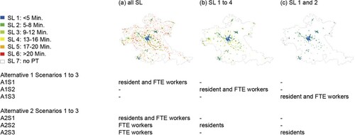
Table 1. Ratio of residents to FTE workers for Service Level Zones (SLZs), 0.5 km radius catchment area of public transport stops for present and projected (two alternatives (A1 and A2) with three scenarios each (S1, S2, S3)) land use.
Two intensity measurements are taken for each of present and future land use. First, the number of hectares reaching the thresholds for all people, residents, FTE workers and FTE retail workers are calculated for the three catchment areas. Second, the maxima are determined by identifying the highest number of all people, residents, FTE workers, FTE retail workers for the three catchment areas.
3.2 Measuring balance of land use
The ratio is measured by dividing the sum of each hectare of residents by the sum of each hectare of FTE workers for each hectare within the radius of the 0.5 km radius catchment area for present, and projected land use.
3.3 Defining threshold values
The thresholds of intensity of land use are defined as follows: The statistical definition used for cities in Switzerland until 2014 referred to a municipality with more than 10,000 residents as a city, independent of whether it satisfied the criteria of compactness. However, this is now checked individually for each municipality (Federal Statistical Office FSO, Citation2014). Nonetheless, 10,000 residents are still taken as the threshold value for catchment areas. The thresholds of balance by housing-job ratios of land use are defined as follows: In 2015, with 8.3 million residents and 4.1 million FTE workers, the active population in FTE in Switzerland corresponds to about half of the population. This is because not all people work at all or full time, such as children, pensioners and part-time workers. At 2.9 Mio. residents and 1.5 Mio. FTE workers, the ratio for Greater Zurich of residents to FTE worker is also nearly two to one. Therefore, the ratio of residents to FTE workers is 2:1. The sum of residents and FTE workers leads to a threshold of 15,000 people.
The housing–job balance in ratio for residents to FTE workers is scaled as follows: between 1.9 and 2.1 is balanced; below 1.9, too many workers in relation to residents and above 2.1, too many residents to workers is imbalanced.
4. Results
The following section presents key results of present and projected intensity and balance of land use of two alternatives with three scenarios each for Greater Zurich.
4.1 Intensity of land use
depicts the base of 2015 and the change in intensity for the two alternatives and three scenarios each. In A1S1, the distribution of land use in building zones does not change as the current number of residents and workers per hectare in building zones is simply doubled. In contrast, in A2S1, no growth in full-time equivalent (FTE) workers is added to service level zones (SLZs) where building zones (BZs) of four minutes and higher frequency, but nearly 50% to SLZs in building zones of 17 min and lower frequency (SLZs 5–7). In A1S2 slightly over a third and A2S2 slightly under a third of the projected distribution of people is added to SLZs in building zones of 9–16 min (SLZ 1–4) and two thirds of eight minutes and higher (SLZs 1 and 2). Finally, for S3, it is 100% for A1S3 and 92% for A2S3, where 12% of the FTE workers are added to SLZs where building zones with connection frequencies of 17 min and lower (SLZs 5–7).
Table 2. Intensity of land use of 0.5 km radius catchment areas of 2015 and projected (two alternatives (A1 and A2) and three scenarios each (S1, S2, S3)) by service level zones (SLZs) for all people, residents and FTE workers.
, depict and in Appendix show that in all six scenarios, the number of hectares that reach the thresholds are several times more than for 2015. It is greatest at A1S3, over 9-fold for people, 62-fold for residents and A1S2 over 4.5-fold for full-time equivalent workers. In addition, the global maximum, which describes the highest peak of distribution of land use in a 0.5 km radius catchment area range from slightly lower than present (A2S1 for FTE workers) to almost quadrupled (A1S3 for residents).
Figure 2. Distribution of current (2015) and projected, three scenarios (S1, S2, S3), land use of Alternative 1 (A1), including local and global maxima of 0.5 km radius catchment areas.
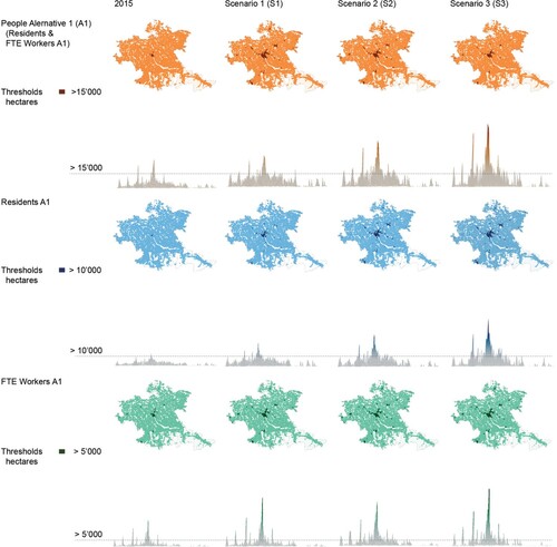
Figure 3. Distribution of current (2015) and projected, three scenarios (S1, S2, S3), land use of Alternative 2 (A2), including local and global maxima of 0.5 km radius catchment areas.
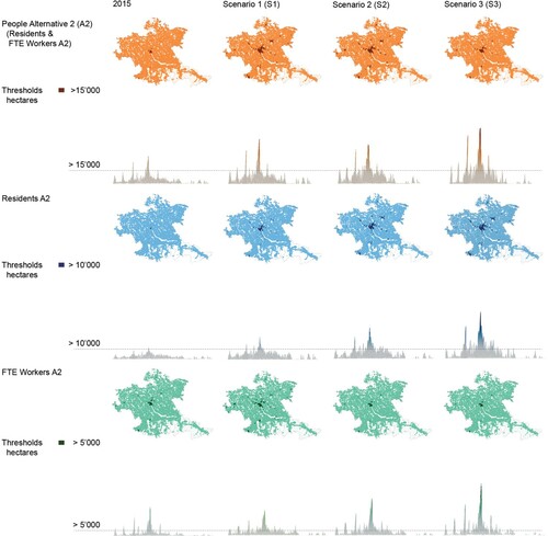
Table 3. Distribution of land use of 0.5 km radius catchment areas of 2015 and projected (two alternatives (A1 and A2) and three scenarios each (S1, S2, S3)) by the number of hectares exceeding thresholds, change from present to projected land use [%] and global maxima for all people, residents and FTE workers.
and in Appendix show that in A1 for all three scenarios FTE workers, as intended, to bring residents closer to jobs, are more concentrated at central locations than in A2, as intended, to bring jobs closer to residents.
Figure 4. Differences in the distribution of land use of 0.5 km radius catchment areas when subtracting Alternative 1 (A1) from alternative 2 (AS) for the three Scenarios (S1, S2, S3).
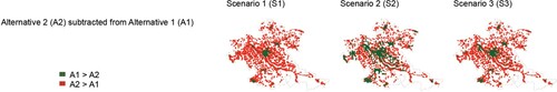
Table 4. Differences in the distribution of projected land use of 0.5 km radius catchment areas when subtracting Alternative 1 (A1) from Alternative 2 (AS) for the three Scenarios (S1, S2, S3).
4.2 Balance of land use
and in Appendix depict that there is not much difference between present and projected land use in terms of proportion of hectares. When looking at the city of Zurich, it is found that in A1S1, the ratio of workers to residents stays indifferent, thus excluding the possibility of residents living closer to jobs. In A2S2, as depicted in , the ratio of workers to residents lying at a ratio of 1.6 residents to 1 FTE workers, is closer to a balanced ratio of 2 : 1. However, as shown in , the number of workers barly changes. Considering that the city of Zurich accounts for 25% of the jobs of Greater Zurich, it is very unlikely that there will be almost no growth in workers. Meanwhile, S2 and S3 of both alternatives are similar to the ratio of A2S1.
Figure 5. Balance in the distribution of living and working of 0.5 km radius catchment areas by the number and proportion of hectares exceeding thresholds. Where < 1.9 too many FTE workers in relation to residents and where > 2.1 too many residents in relation to FTE workers, and where 1.9 to 2.1 balanced ratio.
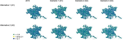
Table 5. Balance in the distribution of residents and FTE workers of 0.5 km radius catchment areas of 2015 and projected (two alternatives (A1 and A2) and three scenarios each (S1, S2, S3)) by the number and proportion of hectares exceeding thresholds.
5. Discussion
The underlying question is where the future growth in residents and full-time equivalent (FTE) workers should be directed for the parsimonious land use required by the Spatial Planning Act (SPA). This discussion encompasses the overall impact of the key findings described above. The six scenarios help determine the impact of planning decisions on land consumption in the guidance towards parsimonious land use at suitable locations. Their variations in coordination with public transport show how land is used in current building zones and could be used in the future if the building and zoning regulations were adapted (section 3.1) and where building zones could be expanded in the interest of parsimonious land use (section 3.2.). In addition, Section 3.3 discusses how the implementation deficit in the guidance towards parsimonious land use could be overcome since the projection results are not a self-fulfilling prophecy.
5.1 How to use land in current building zones
As seen in , and in Appendix , the highest number of hectares that reach the thresholds for FTE workers appear in S2s, and for residents and people in S3s. They also show that S3s have the largest global maxima. However, the over 90,000 people in a 0.5 km radius catchment area projected in A1 and nearly 100,000 people projected in A2 for S1s might be harder to reach than the approximately 65,000 in the S2s of both alternatives. In particular, the restrictions imposed by the protection of historical heritage mean that the global maxima within the historic City of Zurich are difficult to reach. However, as Glaeser (Citation2011) states by the example of Paris, too much preservation stops cities from providing newer, taller and better buildings for their inhabitants and makes popular areas unaffordable. In contrast, the capacity threshold of public space might not allow the global maxima of S3 to be reached. As Bertaud (Citation2018) outlines, the maximum intensity of land use is to be determined by road capacity based on the allocation of space to the modes of transport and not design. Therefore, in terms of global maxima the more realistic scenarios appear to be S2s and, by bringing residents closer to jobs, A1S2 in particular.
5.2 Where to extend building zones
It should be noted that none of the land use distributions projected in the six scenarios would be possible under the current municipal land use regulations. Moreover, the assumption that growth will be limited to current building zones is not very realistic. This is partly because the revised Spatial Planning Act (SPA), in line with expected population growth, allows municipalities to extend their building zones every 15 years. As urban economic theories show, additional land use is natural as long as the population grows and becomes richer and/or transportation costs decrease. However, in guidance for parsimonious not every location is suitable for the expansion of building zones. Not every hectare within a radius of 0.5 km of a public transport stop is also located in a building zone. Some of these locations would reach the thresholds for people, FTE workers or residents, in a 0.5 km radius catchment area. They would therefore be in a better position to absorb future growth than locations that lie in building zones that, according to the scenarios’ projections, either do not meet the thresholds or are not located within a 0.5 km radius of a public transport stop with a service level of 16 min or more frequently, or both. The absorption of growth at less suitable locations leads not only to greater dependency on motor transport but also to less efficient land use for building and moving, which is at odds with parsimonious land use. As Brueckner (Citation2011) shows, in the presence of open-space amenities price-based regulations of a development fee in combination with congestion fee could be used to determine the socially optimal size of cities. Therefore, price-based regulations could replace the quantity-based growth boundaries of building zones and eliminate the unintended consequences of unnatural sprawl, urban blight, affordable housing crisis and welfare loss described in section 2.
5.3 How to overcome the implementation deficit
The six scenarios presented in this paper show which locations are suitable for intensifying land use from current land use intensities, building zones and public transport stop service levels. However, the question remains how this intensification of land use can be achieved. Griffel (Citation2017) has shown that Switzerland is still suffering from the implementation deficit of the SPA passed in 1980. The revision in 2014 might have an impact. The revised SPA demands the integration of a value added tax to compensate for planning advantages, at least for newly added building zones. The cantons have been given a more important role in seeking parsimonious land use through their structure plans. Doubts remain, however, as long as the way in which structurer plans are drawn does not change. Therefore, it is the duty of the cantons to draw up appropriate structure plans and the duty of the Confederation to monitor these structure plans in their guidance for parsimonious land use. The GIS analysis instrument developed by the SNSF research project could be an aid in doing so.
Since the land use regulations are issued by the municipalities, nothing changes if the municipalities are not urged to change them for parsimonious land use. After all, as Gabbe (Citation2019) shows for Silicon Valley, even a regional housing shortage does not necessarily lead to major regulatory reactions in the affected municipalities. In 2015, the Stadt Zürich (Präsidialdepartement Citation2019) had low vacancy rates at 0.22% and high land prices of up to 60,000 CHF per square metre, indicative of regulatory behaviour similar to that demonstrated in Silicon Valley. It is questionable whether purely quantity-based regulations that are normative, static and exclusionary in nature and intended to minimize negative externalities locally will ever be capable of guiding for parsimonious urban land use.
To overcome purely quantity-based regulations deficit, Elliott (Citation2008) proposes a management tool with standards that change automatically in predictable ways. A tool that can be combined with FBC to provide design elements for typologies. Bertaud (Citation2018) sees the power of quantity-based regulations in the allocation and design of the public space. They show that the integration of price-based regulations to internalize negative externalities is essential in the guidance towards parsimonious land use. Further studies shown that such integration can be achieved by a combination of three fees: impact fees on building, as suggested by Glaeser (Citation2011), Leinberger (Citation2009) and Brueckner (Citation2011) development fees in the presence of open-space amenities, as Brueckner (Citation2011) demonstrates, and congestion fees on mobility, as proposed by Glaeser (Citation2011) and Brueckner (Citation2011). Consequently, future land use planning can be context-dependent, conditional, dynamic and inclusionary rather than, as currently, normative, static and exclusionary.
6. Conclusions
This paper presents the GIS analysis instrument developed within the SNSF research project for projecting the distribution of future growth among residents and fulltime-equivalent (FTE) workers within a radius of 0.5 km catchment area based on current land use intensities, building zones and the service levels of public transport stops. It is intended to aid decision-making in the reform of spatial plans for parsimonious land use, in particular the reform of cantonal and regional structure plans and municipal land use plans. Furthermore, it provides an approach to identifying the requirements for parsimonious land use.
Based on these findings it can be concluded that: Land use planning measures serve parsimonious land use if (i) growth in population and labour are planned and demanded in a place where public transport stops are within walking distance (maximum 0.5 km) and public transport stops have a frequency of at least one departure every 16 min; (ii) the planned growth permits at least 15,000 residents and full-time equivalent workers in an area with a radius of 0.5 km catchment area or less; and (iii) the planned growth will result in the ratio of two residents to FTE worker in proximity.
The two alternatives with three scenarios each presented show that the concentration of growth at central locations with public transport service level of eight minutes and higher leads (S1s) to the highest land use intensity at suitable location. However, if growth is added to locations with public transport connections every 16 min (S2s), global maxima are less extreme and are more compatible with historical preservation. Nonetheless, current land use regulations severely constrain growth at suitable locations. If Greater Zurich were to aim for parsimonious land use, then the municipalities land use regulations would need to be changed. Both at locations suitable for parsimonious land use, to enable growth, and at locations not suitable for parsimonious land use, to constrain growth. Because local governments often do not see a need to change, as Glaeser (Barr Citation2018) points out, government at the cantonal level must therefore guide municipalities to use land sparingly and, in particular, urge them to allow more housing where it is needed.
The GIS analysis instrument is based on annually updated geodata on residents and FTE workers on a hectare-coordinate basis and geodata on public transport stops including service levels. Consequently, there are limitations on the extent to which these findings can be generalized outside Switzerland, if such data have not yet been collected.
To reform the land use regulations price-based regulations need to supplement quantity- and design-based instruments so that the causer bears the full costs, in particular the negative externalities. Impact fees serve this purpose (Glaeser Citation2011; Leinberger Citation2009; and Brueckner Citation2011). In addition, public revenue should be generated from land rent (Fred E. Foldvary Citation2006; Fred Emanuel Foldvary and Minola Citation2017; Minola, Foldvary, and Andersson Citation2019), and economic and agglomeration rent collected (Collier and Venables Citation2018; Collier Paul Citation2018) for redistribution.
If parsimonious land use is to be achieved in suitable locations in Greater Zurich, multi-level multi-scale governance must be established in Greater Zurich. The GIS analysis instrument developed in the SNSF project and presented in this paper can be used as a tool for the needed paradigm shift towards systematic settlement and mobility development in Greater Zurich. Consequently, in order to effect control in the direction of economical land use, the cantonal and regional structure plans as well as the communal land use plans must be amended. Lastly, the GIS analysis instrument is to be developed further in support of government and planning's shift away from minimizing negative externalities to internalizing them through price-based regulations in their pursuit of parsimonious land use.
SupplementaryMaterialnew.docx
Download MS Word (13.9 KB)Acknowledgements
The author thanks the anonymous reviewers and colleagues for their comments on earlier versions of this manuscripts. These have contributed substantially to the outcome of this paper. A thank you to Simon Milligan for editing.
Disclosure statement
No potential conflict of interest was reported by the author.
Additional information
Funding
References
- Alexander, E., Luigi Mazza, and Stefano Moroni. 2012. “Planning Without Plans? Nomocracy or Teleocracy for Social-Spatial Ordering.” Progress in Planning 77 (2): 37–87. doi:https://doi.org/10.1016/J.PROGRESS.2011.12.001.
- Alfonzo, Mariela. 2005. “To Walk or Not to Walk.” Environment and Behaviour 37 (6): 808–836. doi:https://doi.org/10.1177/0013916504274016.
- Alonso, William. 1964. Location and Land Use: Toward a General Theory of Land Rent. Cambridge, MA: Harvard University Press.
- Barr, J. 2018. “Skyscrapers and Cities: A Q&A Interview with Edward Glaeser (Part I).” 2018.
- Bertaud, Alain. 2018. Order Without Design How Markets Shape Cities. Kindle Edition. Cambridge, MA: MIT Press.
- Bertaud, Alain, and J. Brueckner. 2005. “Analyzing Building-Height Restrictions: Predicted Impacts and Welfare Costs.” Regional Science and Urban Economics 35 (2): 109–125. doi:https://doi.org/10.1016/j.regsciurbeco.2004.02.004.
- Brueckner, J. 1987. “The Structure of Urban Equilibria: A Unified Treatment of the Muth-Mills Model.” In Handbook of Regional and Urban Economics, 2:821–845. Amsterdam: Elsevier Science Publishers. https://doi.org/https://doi.org/10.1016/S1574-0080(87)80006-8
- Brueckner, J. 2007. “Urban Growth Boundaries: An Effective Second-Best Remedy for Unpriced Traffic Congestion?” Journal of Housing Economics 16 (3–4): 263–273. doi:https://doi.org/10.1016/j.jhe.2007.05.001.
- Brueckner, J. 2011. Lectures on Urban Economics. Cambridge, MA: MIT Press.
- Brueckner, J., and R. Helsley. 2011. “Sprawl and Blight.” Journal of Urban Economics 69 (2): 205–213. doi:https://doi.org/10.1016/j.jue.2010.09.003.
- Brueckner, J., and K. Sridhar. 2012. “Measuring Welfare Gains from Relaxation of Land-Use Restrictions: The Case of India’s Building-Height Limits.” Regional Science and Urban Economics 42 (6): 1061–1067. doi:https://doi.org/10.1016/j.regsciurbeco.2012.08.003.
- Buehler, Ralph, John Pucher, Regine Gerike, and Thomas Götschi. 2016. “Transport Reviews Reducing Car Dependence in the Heart of Europe: Lessons from Germany, Austria, and Switzerland.” https://doi.org/https://doi.org/10.1080/01441647.2016.1177799
- Bundesamt für Statistik (BFS). 2015. “Szenarien Zur Bevölkerungsentwicklung Der Schweiz 2015-2045.” https://www.bfs.admin.ch/bfs/de/home/statistiken/bevoelkerung/zukuenftige-entwicklung/schweiz-szenarien.assetdetail.350324.html.
- Bundesamt für Raumentwicklung (ARE). 2003. “Siedlungsbegrenzung Für Eine Nachhaltige Siedlungsentwicklung.” https://www.are.admin.ch/are/de/home/medien-und-publikationen/publikationen/siedlung/siedlungsbegrenzung-fur-eine-nachhaltige-siedlungsentwicklung.html
- Cervero, Robert. 1988. “Land-Use Mixing and Suburban Mobility.” Transportation Quarterly 42 (3): 429–446. doi:https://doi.org/10.1068/a201285.
- Cervero, Robert. 1989. “Jobs-Housing Balancing and Regional Mobility.” Journal of the American Planning Association 55: 136–150. doi:https://doi.org/10.1080/01944368908976014.
- Cervero, Robert. 1996. “Jobs-Housing Balance Revisited.” Journal of the American Planning Association 62 (4): 492. doi:https://doi.org/10.1080/01944369608975714.
- Cervero, Robert, and Jennifer Day. 2008. “Suburbanization and Transit-Oriented Development in China.” Transport Policy 15 (5): 315–323. doi:https://doi.org/10.1016/J.TRANPOL.2008.12.011.
- Chatman, D. 2013. “Does TOD Need the T?” Journal of the American Planning Association 79 (1): 17–31. doi:https://doi.org/10.1080/01944363.2013.791008.
- Cheshire, Paul, C. Hilber, and H. Koster. 2018. “Empty Homes, Longer Commutes: The Unintended Consequences of More Restrictive Local Planning.” Journal of Public Economics 158 (February): 126–151. doi:https://doi.org/10.1016/J.JPUBECO.2017.12.006.
- Cheshire, Paul, and Stephen Sheppard. 2002. “The Welfare Economics of Land Use Planning.” Journal of Urban Economics 52 (2): 242–269. doi:https://doi.org/10.1016/S0094-1190(02)00003-7.
- Cheshire, Paul, and Stephen Sheppard. 2005. “The Introduction of Price Signals Into Land Use Planning Decision-Making: A Proposal.” Urban Studies 42 (4): 647–663. doi:https://doi.org/10.1080/00420980500060210.
- Cheshire, Paul and Vermeulen, W. 2009. “Land Markets and their Regulation: The Welfare Economics of Planning.” In International Handbook of Urban Policy, Vol. Ii: Issues in the Developed World. Elgar original reference. edited by H. S. Geyer. Cheltenham: Edward Elgar Publishing. http://eprints.lse.ac.uk/30787/.
- Chin, A. 1996. “Containing Air Pollution and Traffic Congestion: Transport Policy and the Environment in Singapore.” Atmospheric Environment 30 (5): 787–801. doi:https://doi.org/10.1016/1352-2310(95)00173-5.
- Chiodelli, Francesco, and Stefano Moroni. 2016. “Zoning-Integrative and Zoning-Alternative Transferable Development Rights: Compensation, Equity, Efficiency.” Land Use Policy 52 (March): 422–429. doi:https://doi.org/10.1016/j.landusepol.2016.01.006.
- Collier, Paul, and Anthony Venables. 2018. “Who Gets the Urban Surplus?” Journal of Economic Geography, doi:https://doi.org/10.1093/jeg/lbx043.
- Delloye, Justin, Rémi Lemoy, and Geoffrey Caruso. 2019. “Alonso and the Scaling of Urban Profiles.” Geographical Analysis, February, gean.12191. https://doi.org/https://doi.org/10.1111/gean.12191
- Die Bundesversammlung der Schweizerischen Eidgenossenschaft. 2014. “Bundesgesetz Über Die Raumplanung (Raumplanungsgesetz, RPG).” https://www.admin.ch/opc/de/classified-compilation/19790171/201405010000/700.pdf
- Ehrlich, Maximilian, Christian Hilber, and Olivier Schöni. 2018. “Institutional Settings and Urban Sprawl: Evidence from Europe.” Journal of Housing Economics 42 (December): 4–18. doi:https://doi.org/10.1016/J.JHE.2017.12.002.
- Elliott, Donald. 2008. A Better Way to Zone: Ten Principles to Create More Livable Cities. Washington, DC: Island Press.
- Elliott, Donald, Matthew Goebel, and Chad Meadows. 2012. “The Rules That Shape Urban Form.”
- Ewing, Reid, and Robert Cervero. 2017. “‘Does Compact Development Make People Drive Less?’ The Answer Is Yes.” Journal of the American Planning Association 83 (1): 19–25. doi:https://doi.org/10.1080/01944363.2016.1245112.
- Foldvary, Fred. 2006. “The Ultimate Tax Reform: Public Revenue from Land Rent.” Vol. 408. http://www.foldvary.net/works/policystudy.pdf
- Foldvary, Fred, and Luca Minola. 2017. “The Taxation of Land Value as the Means Towards Optimal Urban Development and the Extirpation of Excessive Economic Inequality.” Land Use Policy 69 (December): 331–337. doi:https://doi.org/10.1016/j.landusepol.2017.09.022.
- Federal statistical office (FSO). 2014. “Neue Statistische Agglomerations- und Stadtdefinition 2012.” 2014. https://www.bfs.admin.ch/bfs/de/home/statistiken/kataloge-datenbanken/medienmitteilungen.assetdetail.38618.html.
- Fujita, Masahisa. 1989. Urban Economic Theory. Urban Economic Theory. Cambridge: Cambridge University Press. . https://doi.org/https://doi.org/10.1017/cbo9780511625862
- Fujita, Masahisa, and Hideaki Ogawa. 1982. “Multiple Equilibria and Structural Transition of Non-Monocentric Urban Configurations.” Regional Science and Urban Economics 12 (2): 161–196. doi:https://doi.org/10.1016/0166-0462(82)90031-X.
- Gabbe, C. J. 2019. “Local Regulatory Responses During a Regional Housing Shortage: An Analysis of Rezonings in Silicon Valley.” Land Use Policy 80 (January): 79–87. doi:https://doi.org/10.1016/J.LANDUSEPOL.2018.09.035.
- Garde, Ajay, and Andrea Hoff. 2017. “Zoning Reform for Advancing Sustainability: Insights from Denver’s Form-Based Code.” https://doi.org/https://doi.org/10.1080/13574809.2017.1337495
- Garde, Ajay, and Cecilia Kim. 2017. “Form-Based Codes for Zoning Reform to Promote Sustainable Development: Insights from Cities in Southern California.” Journal of the American Planning Association 83 (4): 346–364. doi:https://doi.org/10.1080/01944363.2017.1364974.
- Gennaio, Maria-Pia, Anna Hersperger, and Matthias Bürgi. 2009. “Containing Urban Sprawl—Evaluating Effectiveness of Urban Growth Boundaries Set by the Swiss Land Use Plan.” Land Use Policy 26 (2): 224–232. doi:https://doi.org/10.1016/J.LANDUSEPOL.2008.02.010.
- Gerber, Jean-David. 2016. “The Managerial Turn and Municipal Land-Use Planning in Switzerland-Evidence from Practice.” Planning Theory & PracTice 17 (2): 192–209. doi:https://doi.org/10.1080/14649357.2016.1161063.
- Glaeser, Edward. 2011. Triumph of the City: How Our Greatest Invention Makes Us Richer, Smarter, Greener, Healthier, and Happier. New York: Penguin Group USA.
- Glaeser, Edward, and Joseph Gyourko. 2002, March. “The Impact of Zoning on Housing Affordability.” SSRN Electronic Journal. doi:https://doi.org/10.2139/ssrn.302388.
- Glaeser, Edward, and Joseph Gyourko. 2003. “The Impact of Building Restrictions on Housing Affordability.” FRBNY Policy Review, no. June: 21–39. https://doi.org/https://doi.org/10.1017/CBO9781107415324.004
- Glaeser, Edward, Joseph Gyourko, and Raven Saks. 2005. “Urban Growth and Housing Supply,” January. https://doi.org/https://doi.org/10.3386/w11097
- Goh, Mark. 2002. “Congestion Management and Electronic Road Pricing in Singapore.” Journal of Transport Geography 10 (1): 29–38. doi:https://doi.org/10.1016/S0966-6923(01)00036-9.
- Griffel, Alain. 2017. Raumplanungs- und Baurecht - in a Nutshell. Zürich/St. Gallen.
- Gyourko, Joseph, and Raven Molloy. 2015. “Regulation and Housing Supply.” In Handbook of Regional and Urban Economics, 1289–1337. https://doi.org/https://doi.org/10.1016/B978-0-444-59531-7.00019-3
- Hansen, Gail. 2014. “Design for Healthy Communities: The Potential of Form-Based Codes to Create Walkable Urban Streets.” https://doi.org/https://doi.org/10.1080/13574809.2013.870466
- Hersperger, Anna, Maria-Pia Gennaio Franscini, Daniel Kübler, and Maria-pia Gennaio Franscini. 2013. “Actors, Decisions and Policy Changes in Local Urbanization.” https://doi.org/https://doi.org/10.1080/09654313.2013.783557
- Hilber, Christian, and Wouter Vermeulen. 2016. “The Impact of Supply Constraints on House Prices in England.” Economic Journal 126 (591): 358–405. doi:https://doi.org/10.1111/ecoj.12213.
- Leinberger, Christopher. 2009. The Option of Urbanism: Investing in a New American Dream. Washingtion, D.C: Kindle.
- Mills, Edwin. 1967. “An Aggregative Model of Resource Allocation in a Metropolitan Area.” The American Economic Review 57 (2): 197–210. doi:https://doi.org/10.2307/1821621.
- Mills, Edwin. 1972. Studies in the Structure of the U rban Economy. Baltimore: The Johns Hopkins Press. Maryland 21218 ($7.00).
- Mills, Edwin. 2005. “Why Do We Have Urban Density Controls?” Real Estate Economics 33 (3): 571–585. doi:https://doi.org/10.1111/j.1540-6229.2005.00130.x.
- Minola, Luca, Fred Foldvary, and David Andersson. 2019, August. “Fiscal Principles for Self-Organizing Cities.” Environment and Planning B: Urban Analytics and City Science. 239980831986646. doi:https://doi.org/10.1177/2399808319866460.
- Moroni, Stefano. 2010. “Rethinking the Theory and Practice of Land-Use Regulation: Towards Nomocracy.” Planning Theory 9 (2): 137–155. doi:https://doi.org/10.1177/1473095209357868.
- Moroni, Stefano, and Luca Minola. 2019. “Unnatural Sprawl: Reconsidering Public Responsibility for Suburban Development in Italy, and the Desirability and Possibility of Changing the Rules of the Game.” Land Use Policy 86 (July): 104–112. doi:https://doi.org/10.1016/J.LANDUSEPOL.2019.04.032.
- Muth, Richard. 1969. Cities and Housing: The Spatial Pattern of Urban Residential Land Use. Chicago: The University of Chicago Press.
- Nieuwenhuijsen, Mark, and Haneen Khreis. 2016. “Car Free Cities: Pathway to Healthy Urban Living.” Environment International 94 (September): 251–262. doi:https://doi.org/10.1016/J.ENVINT.2016.05.032.
- Paul, Collier. 2018. The Future of Capitalism. 1st ed. New York: Harper.
- Rauws, Ward. 2017. “Embracing Uncertainty Without Abandoning Planning.” DisP - The Planning Review 53 (1): 32–45. doi:https://doi.org/10.1080/02513625.2017.1316539.
- Saelens, Brian, and Susan Handy. 2008. “Built Environment Correlates of Walking: A Review.” Medicine and Science in Sports and Exercise. NIH Public Access. doi:https://doi.org/10.1249/MSS.0b013e31817c67a4.
- Singh, Yamini, Azhari Lukman, Johannes Flacke, Mark Zuidgeest, and M. F. A. M. Van Maarseveen. 2017. “Measuring TOD Around Transit Nodes - Towards TOD Policy.” Transport Policy 56 (May): 96–111. doi:https://doi.org/10.1016/J.TRANPOL.2017.03.013.
- Stadt Zürich Präsidialdepartement. 2019. “Leerwohnungszählung.” https://www.stadt-zuerich.ch/prd/de/index/statistik/themen/bauen-wohnen/leerwohnungen-leerflaechen/leerwohnungszaehlung.html
- Staricco, Luca, and Elisabetta Vitale Brovarone. 2020. “Implementing TOD Around Suburban and Rural Stations: An Exploration of Spatial Potentialities and Constraints." Urban Research & Practice 13 (3): 276–299.
- Talen, Emily. 2009. “Design by the Rules: The Historical Underpinnings of Form-Based Codes.” Journal of the American Planning Association 75: 144–160. doi:https://doi.org/10.1080/01944360802686662.
- Talen, Emily. 2012. City Rules: How Regulations Affect Urban Form. Washington, DC: Island Press.
- Talen, Emily. 2013. “Zoning For and Against Sprawl: The Case for Form-Based Codes.” Journal of Urban Design 18 (2): 175–200. doi:https://doi.org/10.1080/13574809.2013.772883.
- Wälty, Sibylle. 2021. “Greater Zurich Does Not Use Land Parsimoniously: Despite the Spatial Planning Act, Which Has Been in Force Since 1980.” Journal of Urbanism: International Research on Placemaking and Urban Sustainability 14 (1): 58–74. doi:https://doi.org/10.1080/17549175.2020.1762707
- Weilenmann, Barbara, Irmi Seidl, and Tobias Schulz. 2017. “The Socio-Economic Determinants of Urban Sprawl Between 1980 and 2010 in Switzerland.” Landscape and Urban Planning 157 (January): 468–482. doi:https://doi.org/10.1016/j.landurbplan.2016.08.002.
- Wheaton, William. 1974. “A Comparative Static Analysis of Urban Spatial Structure.” Journal of Economic Theory 9 (2): 223–237. doi:https://doi.org/10.1016/0022-0531(74)90068-4.