
Abstract
Pedestrian navigation has become an important theoretical and practical research topic in many disciplines such as cartography, geographical information science, global and indoor positioning, spatial behavior, psychology, sociology, and neuroscience. Many research studies view pedestrian navigation using process-oriented and goal-directed approaches. However, this paper revisits people’s needs in pedestrian navigation and classifies their needs as three layers: physical sense layer, physiological safety layer, and mental satisfaction layer according to Maslow’s theory. This paper introduces a people-centric framework for pedestrian navigation theory based on these three layers and discusses theoretical challenges for meeting each layer of people’s needs. These challenging theories may represent promising and valuable research and promote usage of pedestrian navigation systems or devices in the future.
1. Introduction
Pedestrian navigation is one of the most fundamental spatial behaviors, skills, and services of people, and is very helpful when they encounter unfamiliar environments. Current research or industry usually views pedestrian navigation as a process-oriented and goal-directed human behavior. Pedestrian navigation applications are designed for people. However, because interactions and mutual influences between humans and the environment are so complicated (Citation1), pedestrian navigation systems do not easily understand people’s needs in a manner compatible with computer intelligence. People-centric pedestrian navigation approach concentrates on acceptable feelings and navigation behaviors of people, while process-oriented and goal-directed human behavior do not pay much attention on the feelings of people. Therefore, pedestrian navigation systems should be researched and designed using a people-centric approach rather than only process-oriented and goal-directed methods. All innovative pedestrian navigation theory and technology should focus on people-centric cognition, understanding, interaction, and preference, so that they can service people in comfortable, respectful, and confident ways to meet pedestrian’s needs in all aspects of physical sense, physiological safety, and mental satisfaction. This is a critical requirement for pedestrian navigation researchers. Consequently, two fundamental questions in the literature are: (1) What are people’s needs in pedestrian navigation? (2) How does one design a people-centric theory framework for pedestrian navigation?
Pedestrian navigation has been one of the most common research topics in the community of spatial behavior of geography, geographical information systems (GIS), as well as outdoor/indoor positioning technology and application. These communities have made great progress for decades, and they have improved spatial skills or aided the process of pedestrian navigation. For example, pedestrian information requirements were investigated (Citation2), design of pedestrian navigation for indoor and outdoor environments was discussed (Citation3), and user preference in pedestrian navigation was considered (Citation4). However, they rarely investigate the needs of people in navigation from the perspective of Maslow’s theory (Citation5−7), which is a very popular psychology theory in sociology research, and could be helpful in analyzing pedestrian’s needs in aspects of physical sense, physiological safety, and mental satisfaction. This paper first revisits people’s needs in pedestrian navigation under the guidance of Maslow’s theory, and then concludes consideration of these needs in a people-centric manner that sums up detailed needs of people within physical sense, physiological safety, and mental satisfaction layers. Moreover, this paper proposes a people-centric theory framework for pedestrian navigation that meets people’s needs. Achieving this framework is still challenging in disciplines of cartography, geographical information science, global and indoor positioning, spatial behavior, psychology, sociology, and neuroscience. However, it may represent a clear research direction that directs pedestrian navigation toward people-centric thinking.
The following parts in this section review research from the perspectives of spatial behavior of geography, GIS, outdoor/indoor positioning technology, and individual applications.
1.1. Perspective of spatial behavior of geography
Wayfinding and navigation are two basic ways that describe the process behind human movement behavior (Citation1, 8). They are instinctive behaviors of people. Wayfinding was formally defined by Lynch in 1960, and considered as “the process of finding way to a destination in a familiar or unfamiliar setting using any cues given by the environment” (Citation9). Wayfinding involves four basic stages: orientation, route decision, route monitoring, and destination recognition. The complicated factors that are involved in these four stages include human and environmental factors. For example, human factors are “spatial orientation, cognitive mapping abilities, route strategies, language, culture, gender and biological factors” (Citation9). Environmental factors include the nodes, edges, paths, districts, landmarks, and signs (Citation9). The interplay of human and environmental factors, and the way these factors affect wayfinding behaviors among varied people are two core questions in spatial behavior study. In practice, “Wayfinding encompasses all of the ways in which people (and animals) orient themselves in physical space and navigate from place to place” (https://en.wikipedia.org/wiki/Wayfinding). Examples include wayfinding graphs (Citation10), cognitive maps (Citation8), 3D maps (Citation11), and landmarks (Citation12−18). Rich literature on the spatial cognitive aspect of wayfinding (Citation19−21) exists. Ref. (Citation21), which incorporates perceptual, cognitive, and contextual aspects, is an important concept and approach to studying cognition of wayfinding. Landmark-based instructions enable pedestrians to comprehend efficiently the visual prominence, semantic salience, and structural significance of landmarks (Citation17, 18, 21−26). These methods must emphasize consideration of varying spatial behavioral factors of people, which include spatial abilities, spatial cognition (Citation25), and spatial decisions.
Pedestrian navigation focuses on the guidance process of pedestrian travel behavior between identifiable origins and destinations. Supporting and enhancing spatial interaction behaviors of pedestrians with environments are crucial to pedestrian navigation. The behavioral strategies for pedestrian navigation are very complicated. Conventional pedestrian navigation applications present users with environmental information through maps and voice guidance based on turn-by-turn instructions or sense of touch (Citation27). To assess the understanding and performance of pedestrian navigation applications in supporting spatial interaction behaviors, several research studies have been conducted. These studies include investigating the performance and user experience of augmented reality, voice, and digital maps (Citation28), evaluating the cartographic communication performance of a route guidance and navigation system (Citation29), presenting a user-centered design project to improve the usability of pedestrian navigation systems (Citation30), analyzing attribution of success (Citation31), as well as considering pedestrian navigation applications for specific groups of people, which include older people (Citation15, 32, 33) and blind pedestrians (Citation34−37). These efforts have not investigated guidance following and unfollowing behaviors of pedestrian navigation derived from route-confirming behaviors. It is important to note that the confirming behaviors are affected by the comprehensive evaluation of human needs by pedestrians when encountering their environments. In short, these research studies did not investigate the comprehensive needs of people from the perspectives of physical sense, physiological safety, and mental satisfaction.
1.2. Perspective of GIS
Pedestrian navigation has received increasing attention by the GIS discipline. Some current research studies have focused on implementing pedestrian navigation applications in GIS. Examples include building a GIS for use in real time for blind travelers (Citation38), developing route recommendations that assist pedestrian wayfinding (Citation39), introducing a framework for pedestrian comfort navigation using multi-modal environmental sensors (Citation40), developing an image-based indoor navigation system called iNavigation (Citation41), enriching topographic road databases (Citation42) and 3D route-planning approaches (Citation43) for routing and navigation, and introducing infrastructure-free indoor navigation (Citation44). Because commercial GIS platforms cannot provide built-in data models for pedestrian navigation, several studies have also focused on modeling pedestrian navigation data in GIS. For example, Lee (Citation45) presented a 3D navigable data model to support emergency responses in microspatial built-environments. Fang et al. (Citation46) presented a GIS data model for landmark-based pedestrian navigation. Garcia Puyol et al. (Citation47) used a geographic tree-based data structure to support indoor pedestrian navigation. Kaiser et al. (Citation48) presented a map-based angular motion model to support a pedestrian system. To facilitate pedestrian navigation, generating navigation graphs or maps is an important task for supporting pedestrian navigation applications. Several studies have been done to support this in GIS, which include generating pedestrian network maps (Citation49) and navigation graphs for indoor spaces (Citation50). To the best of our knowledge, very few research studies on these applications have focused on spatial data concerning people’s needs of physical sense, physiological safety, and mental satisfaction.
There are other approaches related to GIS that aim to support pedestrian navigation. Examples include enhancing indoor/outdoor mobility on campus (Citation51), visualizing distant off-screen landmarks on mobile devices to support spatial orientation (Citation52), using 3D points of interest (Citation53), ubiquitous indoor vision (Citation54), multi-perspective 3D panoramas (Citation55), augmented reality (Citation28, 56), and using virtual environments (Citation57) to support navigation displays. Additional approaches compared sonification methods to represent distance and forward-direction in pedestrian navigation (Citation58, 59), evaluated different navigation aids for tourists (Citation60), simulated pedestrian spatial behaviors (Citation61), and even facilitated navigation for persons with dementia (Citation62). However, GIS did not provide a people-centric approach to handle people’s needs in pedestrian navigation. When GIS is used to design pedestrian navigation systems, representation, guidance, and interaction in GIS require innovation that changes spatial thinking to people-centric thinking.
1.3. Perspective of outdoor/indoor positioning technology and applications
Outdoor/indoor positioning technology is a key approach to sensing a pedestrian’s location, which helps pedestrian navigation systems preload surrounding maps of pedestrians and guide turns along the planned routing step-by-step, even in emergencies (Citation63). Much literature has focused on outdoor/indoor positioning technologies. Global positioning system (GPS) is one of the most used technologies for pedestrian and vehicle navigation. To overcome the lack of GPS signals in some navigation situations (e.g. tunnels, indoors), additional technologies are combined with GPS to provide more accurate locations. For example, recent research studies include the Global Navigation Satellite System (GNSS) (Citation64), Dead Reckoning (Citation65, 66), GPS/GLONASS/QZSS (Citation67), 3D Map Matching (Citation66), visual gyroscope and odometer (Citation68, 69), Inertial Measurement Unit (Citation70−72), Wi-Fi (Citation73), and wireless sensor networks (Citation74). Most of these positioning technologies for navigation applications are only location oriented to provide location information for pedestrians. They are not pedestrian-centric functions that meet physiological and mental needs of pedestrians.
2. Three layers of pedestrian needs in navigation
According to Maslow’s theory, the needs of pedestrians in navigation are classified as three layers: physical sense layer, physiological safety layer, and mental satisfaction layer (Figure ). These layers are introduced individually as follows.
Figure 1. Three layers of pedestrians’ needs.
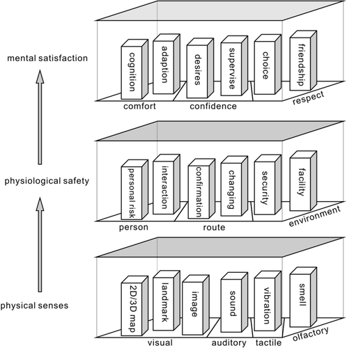
2.1. Physical sense layer
Pedestrians have visual, auditory, tactile, and olfactory senses, which perceive navigation instruction information from pedestrian navigation systems or services. These senses supply navigation instructions to the pedestrian’s brain, and this sensed information can influence decisions of spatial behaviors in surrounding environments. Most research studies only considered the use of some senses and did not have a clearly comprehensive framework that connected or combined these senses. For example, paper or digital map-based visualizations and turn-by-turn-based auditory guidance are the most used senses for guiding pedestrians, while auditory and tactile guidance (Citation75) are the most used senses for visually impaired pedestrians. 2D/3D maps show the neighbor environments of pedestrians, which include the road network, buildings, points of interests, and other information to help them locate themselves in their surrounding environment. Landmarks provide the most predominant visual navigation cues for pedestrian navigation. Landmark-based pedestrian navigation instruction and data models (Citation46) facilitate good pedestrian navigation services. Panoramic images also provide comprehensive image-based information of surrounding environments, which can be used to locate pedestrians by matching those to themselves. Arrow-based visual instructions in these visual maps were also shown to highlight next turns along the planned routes. In addition to the visual sense, the auditory sense is also important in pedestrian navigation, because pedestrians can listen to navigation instructions while walking without looking at the navigation screen to find instructions. Tactile sense is another useful sense that is commonly used for visually impaired pedestrians to perceive supplementary navigation instructions. Different modes of vibration can represent different instructions or operational orders to guide pedestrians. Due to limits of technology, the olfactory sense can only be used in specific environments to hint at environment context. Future research can make full use of olfaction to support navigation, especially for both visually and auditory impaired pedestrians. In short, most of the current pedestrian research or applications only use some of these senses to navigate pedestrians. However, pedestrian navigation research studies need to conduct in-depth analyses and seriously reconsider making full use of these senses to navigate different kinds of pedestrians in familiar or unfamiliar environments. Otherwise, current pedestrian application tools will not attract more potential users of pedestrian navigation. How to combine these senses for pedestrian navigation is a major challenge in current disciplines.
2.2. Physiological safety layer
In addition to concentrating on the senses of pedestrians for interactions with navigation systems or services, pedestrian navigation research studies must also focus on physiological safety issues. From the perspective of a pedestrian’s physiological needs, this paper concludes that some safety aspects must be rethought seriously when we design a pedestrian navigation application. The first aspect is the person’s safety. Pedestrians are usually concerned for their safety in many situations during navigation. For example, pedestrians could fall or cause accidents when they pay too much attention to navigation systems or services, and they could be hurt or misled by a navigation device. In addition, pedestrians frequently need to check the hidden part of scenes on navigation devices. Another important personal safety issue is the interaction between pedestrians and navigation devices or their companions when they are facing an unfamiliar environment. Some researchers investigated interactions between mobile computing devices and users (Citation4, 76, 77), the perceived sense of control (Citation78), and interactions between people and environments (Citation79). It is important to note that pedestrians usually differ in ability to sense direction (Citation80), which could lead them to understand the same navigation instructions as different operational orders. How to ensure that an instruction is understood correctly by different pedestrians is a serious question, which needs to be rethought with caution. Misunderstanding navigation guidance may lead to wrong navigation behaviors and may even cause potential personal risks. The second aspect is the safety of routes. “Safety is a very crucial factor of route quality” (Citation81). If they are unsure whether the current route is correct, pedestrians must frequently confirm their current walking route with the planed route during the process of navigation, because they lack a sense of safety on the route and worry about becoming lost in an unfamiliar environment. This situation will cause a frequent confirming behavior, which could result in a high cognitive load and would not be conducive to a relaxed physiological status. If pedestrians are familiar with parts of a current route and environment, they may change to appropriate routes by themselves. In this situation, they also need a sense of safety in changing the route to finish the rest of the route. The third aspect is safety of the environment. Software errors in satellite navigation devices can occasionally put pedestrians at risk. For example, they can become lost (Citation82) or face an insecure situation. This issue may lead pedestrians to hesitate to believe GPS-based navigators (Citation83). Pedestrians need to make sure that the route is going through a safe environment that does not include dangerous factors prior to arriving at their destinations, so they can ease their physiological nervousness. Facilities are also important safety issues in the environment. Will a facility, such as a gate or ticket machine, along the followed route be used or passed through by pedestrians? For example, pedestrians who are unable to use stairs must check whether a ramp between the parking area and floor is available. Therefore, facilities are important safety factors that influence the ability of pedestrians to reach their destinations.
2.3. Mental satisfaction layer
Mental satisfaction is an important need that pedestrians and researchers easily ignore it. Most research studies in pedestrian navigation concentrate on the ability to deliver instructional information. This is not easy when serving an increasing number of people, and may lead to replacement by other innovative technologies because delivery does not provide mental satisfaction for people. Although Rehrl et al. (Citation28) used the NASA task load index (Citation84) to measure satisfaction with performance of pedestrian navigation, mental satisfaction has not been investigated very comprehensively in the literature. This article states that the satisfaction of pedestrians in the navigation process requires comfort, confidence, and respect. In the aspect of comfort, visual saliency (Citation21) has attracted much attention to assess comfort from the perspective of cognition. There are many factors that influence pedestrian comfort, such as “weather, security, appeal, traffic, pavement conditions” (Citation85), noise, air pollution, and layout of the walkway (Citation40, 86, 87). These factors are mainly derived from the environment. Another type of comfort is derived from using pedestrian navigation systems or services. The human–machine interface, robustness, and reality of navigation functions, predictability of behaviors, and compatibility between spatial abilities of pedestrians and preferences of navigation ways are also important factors that influence the feeling of comfort. All of these factors can be represented as two key concepts, cognition, and adaption. Pedestrians need to recognize these factors about the environment and navigations systems or services in a comfortable way. In addition, pedestrians must adapt to these factors in a very smooth manner. In the aspect of confidence, several research studies have investigated confidence during navigation. For example, traffic light information is used to increase navigation confidence (Citation88), and a navigation score is used to calculate navigation confidence (Citation89). Pedestrians need a sense of confidence from controlling navigation systems or services rather than being controlled by them. The confidence of pedestrians can be achieved when they are satisfied and enjoy supervising navigation systems or services. For example, pedestrians may alter the planned routes of navigation systems or services and arrive at their destinations by passing through a cleaner, more beautiful and appropriate population density environment. They should be more confident and proud of their navigation decisions guided by navigation systems or services than when walking in a congested and slow-traffic environment. In the aspect of respect, pedestrians need navigation systems or services that respect their choices and respond in a friendly manner. For example, a pedestrian will not experience a feeling of respect when he/she chooses and walks a route, but he/she suffers endless instruction alerts, e.g. “make a U-turn (turn back) when possible” from navigation systems or services, which asks them to give up their choices and follow the planned route.
3. People-centric framework for pedestrian navigation theory
In theory, people should be the most important service subject among all components in pedestrian navigation applications such as pedestrian, environment, and navigation system and services. All theories in pedestrian navigation must be rethought and rebuilt using a people-centric theory framework. Figure proposes a people-centric framework for pedestrian navigation theory, which includes components of pedestrian, environment, and navigation system and services and lists theories of the mutual relationships among them according to each layer of a pedestrian’s needs. The relationships between pedestrian, environment, and navigation system and services are illustrated in Figure (see the central circle in orange). A pedestrian interacts with navigation systems and devices and is guided by instructions generated by them. A pedestrian is constrained by the environment and experiences the application process of the pedestrian navigation service in the environment. The navigation system or service senses the pedestrian’s environment, locates the pedestrian, and matches the location within the sensed environment. The following subsections will introduce relationships between the pedestrian, environment, and navigation system and services, and the theories for the three layers of a pedestrian’s needs, respectively.
Figure 2. People-centric pedestrian navigation theory framework.
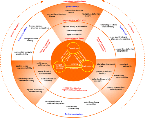
3.1. Theories of physical sense layer
Theories of the physical sense layer are introduced in the following six aspects:
| (1) | Pedestrian: Pedestrians have very complicated spatial abilities and preferences, and theoretical mechanisms of cognition and behavior need to be brought up to date. Pedestrians usually have unique spatial abilities and preferences, capabilities of spatial cognition and sensitivity, as well as driving forces and spatial behaviors. The research communities of spatial cognition and behaviors have provided several theories that model and explain them. “Human Cognitive systems include sensation and perception, thinking, imagery, memory, learning, language, reasoning and problem-solving. Spatial properties include location, size, distance, direction, separation and connection, shape, pattern, and movement” (Citation90). Numerous disciplines, including psychology, cartography, geographic information science, sociology, neuroscience, and artificial intelligence, try to understand spatial cognition of human beings. “Spatial behavior – the movement of people, goods, messages, ideas – takes place in the field of forces” (Citation91). Several research studies have investigated spatial behavior from the perspective of spatial memory in psychology (such as spatial recall and formal theories, Spencer et al. (Citation92) and behavioral geography (Citation1, 8). Pedestrian navigation theory and applications should be adaptable to a user’s spatial preferences. Spatial preference can determine what type of information that they prefer to use and how they prefer to think about and represent the environment (Citation93). Pedestrians’ differences and spatial preferences (Citation93−95) influence the spatial information processing of navigation systems such as route choice preference (Citation96) and preference of representation formats (Citation97). Researchers in psychology and geographic information science still find it a challenge to investigate, model, and represent spatial ability, preference, cognition, and behavior. | ||||
| (2) | Environment: Information technology (such as remote sensing, mobile mapping, and online volunteer geographical information provision) has provided considerable navigable information on the environment that is able to support pedestrian navigation, such as outdoor road network-based navigation databases (including road networks, points of interest, and landmarks), indoor 2D/3D digital navigation maps, and panoramic images. However, current information technology does not provide overall navigable and digital environment maps, such as environmental walkability, space–time accessibility, behavioral features such as fingerprints for intelligent sensors, and facilities for specific types of pedestrians including those that are visually or physically impaired. It is important to note that traditional navigation support information usually focuses on physical facilities, such as the walkable environment, and often ignores information about virtual facilities such as signal strength of a wireless network or Wi-Fi access point due to a requirement for online data download or dynamic information updating. In addition, traditional navigation support information does not provide a behavioral fingerprint database while, for example, executing a sharp turn, taking an elevator, or walking on a slight slope. If a pedestrian’s current positioning technology provides only low-accuracy location results, which could cause drifting or mismatching phenomena in navigation systems, behavioral fingerprint data can help the pedestrian understand the environment and improve the matching accuracy of the environment. The capturing, modeling, and delivering of digital environment maps for pedestrian navigation also requires more powerful information theories and technologies due to refined requirements of pedestrian navigation in different environments. | ||||
| (3) | Navigation system or services: Current navigation systems or services provide online or offline digital GIS navigation maps that support representation of a pedestrian’s surrounding environment and instructions along the planned routes, with alert sounds for necessary turning. However, there are three theories still under development for pedestrian navigation systems or services: multi-sense combination and collaboration, sensing and matching the environment, and the human–machine interface. Current navigation systems or services do not fully use or combine sensory organs of pedestrians. Few systems can support different types of pedestrians, such as visually or physically impaired people, the elderly, and children. How to choose and combine visual, auditory, tactile, and olfactory sensory organs to support different kinds of pedestrians and how to improve their navigation efficiencies are critical questions in navigation research. These choices and utility theories must be more scientific because their navigation load will be influenced by the selected sensory organs and the manner in which they are used (e.g. sequential or synchronous/asynchronous). Also, current navigation systems or services use many positioning technologies to provide locations of pedestrians such as GPS, GNSS, Dead Reckoning, 3D Map Matching, visual gyroscope and odometer, inertial measurement unit, Wi-Fi, and wireless sensor networks. However, due to the limitations in coverage of positioning infrastructures, pedestrian navigation applications cannot provide low-cost and seamless indoor and outdoor positioning and environment-matching techniques to support full coverage of all environments. More effective theories are needed to provide very easy and low-cost sensing and matching techniques. In addition, some human–machine interface theories do support pedestrian navigation applications, such as Freud’s theory and other psychoanalytical theories (Citation98) and activity theory (Citation99), and some research studies have tried to integrate cognitive load theory and concepts of human–computer interaction (e.g. Ref. (Citation100) by Hollender et al.). However, an easy human-environment-device interaction theory and a human interaction load theory for pedestrian navigation need to be developed further to ease tension in the process of pedestrian navigation, especially in unfamiliar environments. | ||||
| (4) | Pedestrian-Environment: The theory between pedestrian and environment can be viewed as a space–time choice and experience theory. Several spatial choice theories have been studied in the literature. For example, a general probabilistic theory called the Choice Theory was developed for modeling a variety of spatial interaction choices by individually behaving units (Citation101). The Gravity model was regarded as a spatial model rule for an individual (Citation102). A general theory of movement and discrete choice theory (Citation103) provided a framework for interaction models. Timmermans and Borgers (Citation104) reviewed fundamentals and trends of dynamic models of choice behavior. A more specific modeling between pedestrian and environment is route choice modeling. “Modeling route choice behavior is problematic, but essential to appraise travelers’ perceptions of route characteristics, to forecast travelers’ behavior under hypothetical scenarios, to predict future traffic conditions on transportation networks and to understand travelers’ reaction and adaptation to sources of information” (Citation105). Prato (Citation105) reviewed route choice modeling within the discrete choice modeling framework. In addition, landmarks provide the most predominant navigational cue for pedestrian navigation. The choice and representation of landmarks require an optimal approach to meet the needs of pedestrians such as shorter distances, fewer turns, and easier confirmation. Fang et al. (Citation17) proposed a multi-objective model to generate optimal landmark sequences for pedestrian route instructions. By acknowledging the merits of these models, this paper suggests additional research studies toward a space–time choice and experience theory to put choice and experience into a space–time context. In this theory, space–time dynamics modeling of choosing, integrating, and experiencing navigable elements (such as routes, landmarks, points of interest, and wireless access points), which are constrained by environment conditions, an individual’s preferences and cognition load, still challenges current choice theories.. | ||||
| (5) | Pedestrian-Navigation system or service: The theory between pedestrian and navigation system or service can be viewed as a space–time predict and guidance theory. Most theories between pedestrian and navigation systems or services focus on interactions and guidance. For example, Gaunet (Citation106) investigated verbal guidance rules for a localized wayfinding aid intended for blind pedestrians in urban areas. Roger et al. (Citation107) investigated the effects of the guide’s interlocutor model, spatial abilities, and use of landmarks on route descriptions in order to define guidelines for designing dialog-based pedestrian guidance applications. Huang and Gartner (Citation108) proposed an evaluation framework for investigating indoor navigation systems. Fallah et al. (Citation109) presented a technical overview of existing indoor human navigation systems and analyzed different techniques used for locating the user, planning a path, representing the environment, and interacting with the user. These research studies have a relatively weak ability to provide appropriate, comfortable, and smooth guidance for pedestrians from a necessary perspective of space and time. By acknowledging the achievements of current research studies on interactions and guidance, this paper suggests that future research in this direction should focus on advancing space–time prediction and guidance theories, because these theories can pre-evaluate a pedestrian’s environment and schedule space–time navigation behaviors that make the pedestrian more comfortable in the environment. The main challenges of space–time prediction and guidance theories include predicting pedestrian dynamics along the planned and candidate routes in dynamic environments, predicting pedestrian preferences toward dynamic environments and behaviors within these environments, representing navigation instructions to different kinds of pedestrians, and the interaction load of pedestrians upon navigation systems. | ||||
| (6) | Environment-Navigation system or service: The theory between environment and navigation system or service can be viewed as a space–time sensing theory in both physical and virtual spaces. In a traditional pedestrian navigation theory framework, a navigation system usually acts as a tool to receive positioning signals and then provides locations of the current pedestrian user to navigation systems. The positioning results by the navigation systems usually are used to match the environment and represent current locations of pedestrians at that time and in the environment. For example, a recent study by Retscher (Citation110) proposed a multi-sensor system for pedestrian navigation and guidance services from the perspective of continuous position determination. Ruotsalainen et al. (Citation68) used a visual gyroscope and a visual odometer to build a pedestrian positioning model. To the best of our knowledge, traditional pedestrian positioning theories reviewed by Harle (Citation111) usually ignore sensing pedestrians in virtual space, which is also important to pedestrian navigation systems. For example, social activity and behavior sensing across social media or online social services (Citation112) can help navigation systems understand the navigation behavioral preferences and predict navigation behaviors in some environments. In addition, when combined with physical navigation systems, interactions in virtual space can help pedestrians improve navigation efficiency by integrating the sensed route and other preferences. A similar concept of social sensing introduced by Liu et al. (Citation113) helps to understand pedestrians’ socioeconomic environments using another version of the social sensing concept to sense interpersonal behavior in real time (Citation114). Results from social sensing will play an important role in understanding pedestrians and their surrounding environments, which could help pedestrian navigation systems become more intelligent and comfortable. Therefore, pedestrian navigation researchers must study a space–time sensing theory in physical and virtual spaces. | ||||
3.2. Theories of physiological safety layer
Theories of the physiological safety layer are introduced in the following six aspects:
| (1) | Pedestrian: Navigation attention theory, navigation decision theory, and navigation behavior theory are the three key theories about pedestrians, which have a strong relationship with physiological safety. Navigation attention theory focuses on the attention mechanism on partial or complete spatial scenes of the environment in the process of pedestrian navigation such as landmarks, routes, visual and auditory instruction, and vibration. For example, Large and Burnett (Citation115) investigated the effect of different navigation voices on trust and attention while using in-vehicle navigation systems. Holland et al. (Citation116) presented a prototype spatial audio user interface for GPS navigation, which allowed mobile users to determine locations while their eyes, hands, or attention were engaged. Navigation decision theory concentrates on spatial decisions about routes, environments, the space–time navigation process, and spatially social decisions. For example, several pedestrian strategies for choosing and describing routes were analyzed (Citation117). Several theoretical models including discrete choice modeling (Citation118) and space syntax modeling (Citation119) were used to model navigation decisions. In particular, Cheung and Lam (Citation120) investigated pedestrians’ choices between escalators and stairways in subway stations. In addition, Chersi and Pezzulo (Citation121) investigated spatial navigation and goal-directed decision-making from the perspective of brain science. Literature in spatial decision theory supports this research; however, more innovative theories are needed to focus on the space–time navigation process and spatially social decisions. Navigation behavior theory deals with the rational and underlying driving forces of navigation behaviors in physical and virtual spaces, and the effect of behaviors on space–time navigation processes. For example, several theoretical models were developed to model pedestrian behaviors such as the social force model (Citation122), self-organizing theory (Citation123), utility maximization (Citation124), discrete choice modeling (Citation125), and an individual-based intermodal simulator for operational behaviors (Citation126). In addition, Zacharias (Citation127) considered pedestrian behavior in planning pedestrian environments. In short, the relevant published research studies focused only on parts of navigation attention theory, navigation decision theory, and navigation behavior theory according to pedestrians’ needs. Additional research is required to contribute to these theories. These studies could improve pedestrian safety and sense of comfort when using pedestrian navigation applications. | ||||
| (2) | Environment: Walkability, space–time accessibility, and context-dependent behavior utility theory are the critical theories about the environment for physiological safety in pedestrian navigation. Walkability, which acts as a measure of the friendliness level that an area is for walking, is a health and safety concept about places, locations, distances, and movements. Pedestrian navigation should consider health, environmental, and economic benefits of walkability, which may be influenced by right-of-way, safety, and accessibility. Some research studies have investigated neighborhood walkability (Citation128), local community walkability (Citation129), and walkability associated with risk (Citation130). The perspectives of walkability studies were reviewed and directions of future studies were introduced in literature such as “different forms of embodiment, movement activities, their relationships to health, and the places, experiences, agency and cultures involved” (Citation131). However, the effects of walkability on pedestrian safety need to be investigated to improve route decisions. Space–time accessibility is a fundamental constraint on pedestrian navigation. Hägerstrand’s space–time prisms are the first constraint-oriented approaches to measure space–time accessibility. A realistic space–time accessibility measure (Citation132) reflects the locations, distances, and travel velocities allowed by an urban transportation network. Other studies (Citation133−136) also improved space–time accessibility measures. Space–time accessibility research can be used to pre-estimate the space–time safety of pedestrians in the navigation process. Context-dependent behavior utility theory concerns the efficiency and utility measure of pedestrians’ navigation behaviors. This theory can provide fundamental information for both pedestrian navigation decisions and environment design. The utility of rational choice was measured by Marschak (Citation137) from the perspective of an economist. A systematic overview of alternative assumption in pedestrian behavior models (Citation138) was introduced, which aimed to optimize the link structure. Additional research studies on behavior utility theory that focus on the pedestrian process in different environments are needed. | ||||
| (3) | Navigation device or service: Spatial sense representability, spatial cognition transformability, and spatial preference understanding are three important theories that can influence the comfort of navigation interactions provided by a navigation system or service. Spatial sense representability theory focuses on how to represent and use the spatial sense of pedestrians. Several studies have investigated the representation of spatial senses such as sense of direction, spatial orientation, cognitive maps (Citation139), spatial sense of the eye (Citation140, 141), and vision (Citation142). However, the mechanism of spatial sense representation for visual, auditory, tactile, and olfactory senses has not been researched comprehensively. Spatial cognition transformability theory focuses on how spatial cognition can be transformed to forms that computational intelligence can understand, and conversely, how to transform computational forms of spatial cognition to an individual’s manner, which challenges the disciplines of psychology, behavior, and GIS. Spatial cognition has been researched for many decades, including an early review of spatial cognition (Citation143), spatial cognition of language (Citation144), anchor-point hypothesis of spatial cognition (Citation145), and visual neglect of spatial cognition (Citation146). However, few studies focus on the transformability theory of spatial cognition, which could influence a machine’s capability to understand in pedestrian navigation systems. Spatial preference understanding theory focuses on understanding pedestrians’ spatial preferences by tracking pedestrian navigation behaviors and mining from large social media. Many studies have been done on spatial preferences of pedestrians, including preferences of environment (Citation93), individual preferences (Citation93−95), route choice preference (Citation96), and preference representation formats (Citation97). However, the automatic sensing and mining capability of spatial preferences have not been investigated in depth. This theory is useful for improving the spatial intelligence of pedestrian navigation systems. In short, future research studies on the above three theories should be very helpful for designing people-centric pedestrian navigation systems or applications. | ||||
| (4) | Pedestrian-Environment: Rational space–time choice theory, route-confirming and changing mechanism, and space–time behavior adaptability are the fundamental theories that improve the sense of safety of a navigation route between a pedestrian and the environment. Spatial choice theory has been researched for decades. This theory needs to be rethought and redefined as a rational space–time choice theory, which could focus on the driving forces, operational mechanism, and rational evaluation approaches of space–time choices in space over time. In particular, the effect of space–time human dynamics must be considered in this theory. The route-confirming and changing mechanism concentrates on when, how, and why pedestrians confirm and change their routes, as well as the confirming and changing behavior patterns of different kinds of pedestrians within varying environments. This mechanism helps in understanding the rational route safety sense of pedestrians in the navigation process. Although much literature has focused on pedestrian behaviors in the environment, the adaptability of space–time behavior of pedestrians has not been investigated, largely for pedestrian navigation systems to design easy ways to make people comfortable when the environment cannot support convenient behaviors. What is navigation behavior adaptability of people? How do people make their behaviors adaptive? What is the maximum limit for changes in navigation behavior? For example, if there is a work zone ahead of them along the route of a pedestrian, could he/she adapt to the limit of the work zone? Different people may have different behavior adaptabilities when they face the same inconvenience, and the same person may have different behavior adaptabilities during the day or night. Therefore, space–time behavior adaptability tries to understand the maximum limit under different environment conditions. In short, future research on the above three theories should be very helpful for understanding the friendly relationship between a pedestrian and the environment. | ||||
| (5) | Pedestrian-Navigation system or service: Human senses-oriented instruction, navigation load theory, and navigation behavior predictability are three important theories that are critical for safe interaction between a pedestrian and a navigation system or service. Human senses-oriented instruction means that the pedestrian navigation instructions must combine senses of pedestrians to provide them with very clear and easy-to-follow instructions. The spatial representation process of each sense and the combination of multi-senses of people are key questions that need to be researched for different groups of people. For example, a pedestrian navigation system or service provides visual map-based instructions to all users, but it does not work for those who are visually impaired. Instruction that is based on voice and vibration may be easier than visual maps for the visually impaired. Navigation load theory includes theories of cognition load, sense load, tension and safety load, and other loads related to psychology in the process of pedestrian navigation. Spatial cognition has been studied extensively. However, sense, tension, and safety loads have not been researched overall in the literature. In addition, the comprehensive navigation load that integrates these loads shall be a promising theory for the disciplines of psychology and GIS. Navigation behavior predictability theory is another interesting and useful theory for pedestrian navigation. There are many research questions on navigation behavior predictability theory. What kind of navigation behaviors are there and to what extent can they be predicted? What is the effect of varying environments on the predictability of navigation behaviors? How can predictability be used to improve sense of safety in pedestrian navigation systems? More research is needed to strengthen this theory. In short, the above three theories are currently not well developed. | ||||
| (6) | Environment-Navigation system or service: Seamless indoor and outdoor integration, continuous sensibility, and adaptive privacy protection are three critical theories that guarantee the safety of pedestrians between the environment and navigation system or service. The seamless indoor and outdoor integration theory not only refers to positioning theory for indoor and outdoor environments, but also to GIS modeling of indoor and outdoor environments and accessible network and behavior support services. This integration theory provides a smooth theoretical foundation for indoor and outdoor positioning, mapping, and service applications. Continuous sensibility is another important theoretical problem for pedestrian navigation applications, which includes sensing surrounding environments in both bright and dark situations, sensing behaviors, indoor and outdoor activities of pedestrians among different environments, and sensing social behaviors in physical and virtual spaces. The sensibility capability supports pedestrian navigation applications with a good pre-assessment of surrounding environments. Adaptive privacy protection is a realistic requirement for online pedestrian navigation applications because these applications are highly location-sensitive, and interactions between pedestrians and these applications are highly real time without more time to handle privacy issues. Location-based and service-based privacy theories are the two main components of adaptive privacy protection theory for pedestrian navigation in both physical and virtual spaces. Current privacy theory needs to be revisited to meet these theoretical requirements. | ||||
3.3. Theories of mental satisfaction layer
Mental satisfaction is at a high level of human needs. People not only need the satisfaction of guiding them to their destination, but they also need to feel satisfaction of comfort, respect, and confidence from the pedestrian navigation system or service when they use it for pedestrian navigation. These three types of satisfaction have a high probability of influencing future use of a pedestrian navigation system or service. Currently, how to achieve satisfactions of comfort, respect, and confidence remains a major challenge for researchers because pedestrians could involve many factors derived from physical sense and physiological safety layers. For example, Lorenz et al. (Citation147) showed that “map perspective and landmarks alone explain about 30% of the variance in the user satisfaction with maps for design indoor navigation maps” (see p 201). Other factors that influence navigation systems include route guidance criteria (Citation148), interface usability (Citation149), gender differences (Citation150), as well as digital map and voice-only interfaces vs. augmented reality (Citation28). Clearly, there is no comprehensive theoretical framework in the literature that can address all types of mental satisfaction in pedestrian navigation.
There are two approaches to assess mental satisfaction in pedestrian navigation. The first approach is a discrete assessment approach, which involves assessing individual factors from the physical sense and physiological safety layers of people’s needs in navigation, and then combining these assessed results in several discrete ways. The second approach is an aggregated assessment approach, which involves proposing mental satisfaction questionnaires and then defining indexes to estimate mental satisfaction in the pedestrian navigation process. In this approach, questions about people’s feelings and ranking must be placed into a space–time context. For example, the emotional status, tension ranking, preference ignorance, and success rate during the entire navigation process could be investigated for future comfort, respect, and confidence assessment. Neither approach can easily answer that question, but they can make great progress in creating innovative and people-centric pedestrian navigation applications.
4. Conclusions
The thinking in pedestrian navigation needs to reshape from process-oriented and goal-directed approaches to a people-centric approach. The people-centric approach will be natural and sustainable to the theoretical and technological innovations of pedestrian navigation. The first contribution of this paper is to classify people’s needs in pedestrian navigation as three layers: a physical sense layer, a physiological safety layer, and a mental satisfaction layer according to Maslow’s theory. The physical sense layer focuses on visual, auditory, tactile, and olfactory senses that pedestrians use to perceive navigation instructions. The physiological safety layer concentrates on the safety perspectives of persons, routes, and environments in pedestrian navigation. The mental satisfaction layer focuses on the satisfaction of pedestrians in the navigation process in terms of the requirements of comfort, confidence, and respect. The second contribution of this paper is to propose a people-centric framework for pedestrian navigation theory according to these three layers of people’s navigation needs and determine the detailed requirements of theoretical studies that support the people-centric framework. In particular, discussion of these theory requirements suggests promising and valuable research and innovative directions for pedestrian navigation, which could influence studies and designs of pedestrian navigation to meet people’s needs perfectly. In short, the perspective of considering people’s needs is critical to innovation in high technology of pedestrian navigation systems or applications, and could be more effective than the popular process-oriented and goal-directed perspectives.
Notes on contributors
Zhixiang Fang is a professor in State Key Laboratory of Information Engineering in Surveying, Mapping and Remote Sensing (LIESMARS) at Wuhan University. His research expertise includes both theoretical aspects and practical applications of pedestrian navigation services, spatiotemporal modeling and analysis.
Qingquan Li is a professor with Shenzhen University, Guangdong, China and Wuhan University, Wuhan. His research interests include 3-D and dynamic modeling in GIS, location-based service, surveying engineering, integration of GIS, GPS and remote sensing, and intelligent transportation system.
Shih-Lung Shaw is the Alvin and Sally Beaman Professor and Arts and Sciences Excellence Professor in the Department of Geography at the University of Tennessee, Knoxville. His research interests include transportation geography, geographic information science (GIScience) and spatio-temporal analysis, especially with topics related to transportation planning and modeling, air transportation, time geography, effects of information and communications technologies (ICT) on human activity and travel patterns, spatiotemporal analysis of human dynamics, space–time GIS, and GIS for transportation (GIS-T).
Additional information
Funding
References
- Golledge, R.G.; Stimson, R.J. Spatial Behavior: A Geographic Perspective; The Guilford Press: New York, 1997.
- May, A.; Ross, T.; Bayer, S.H.; Tarkiainen, M.J. Pedestrian Navigation Aids: Information Requirements and Design Implications. Personal Ubiquitous Comput. 2003, 7 (6), 331–338.10.1007/s00779-003-0248-5
- Radoczky, V. How to Design a Pedestrian Navigation System for Indoor and Outdoor Environments. In Location Based Services and Telecartography: Gartner, G., Cartwright, W., Peterson, M.P., Eds.; Springer-Verlag: Berlin, 2007; pp 301−316.
- Li, C. User Preferences, Information Transactions and Location-Based Services: A Study of Urban Pedestrian Way Finding. Comput. Environ. Urban Syst. 2006, 30 (6), 726–740.10.1016/j.compenvurbsys.2006.02.008
- Maslow, A.H. A Theory of Human Motivation. Psychol. Rev. 1943, 50, 370–396.10.1037/h0054346
- Maslow, A.H. Motivation and Personality; Harper: New York, 1954.
- Maslow, A.H. Toward a Psychology of Being; Van Nostrand: New York, 1968.
- Golledge, R.G. Wayfinding Behavior: Cognitive Mapping and Other Spatial Processes; Johns Hopkins University Press: Baltimore, MD, 1999.
- Farr, A.C.; Kleinschmidt, T.; Yarlagadda, P.; Mengersen, K. Wayfinding: A Simple Concept, a Complex Process. Trans. Rev. 2012, 32 (6), 715–743.10.1080/01441647.2012.712555
- Raubal, M.; Worboys, M. A Formal Model of the Process of Wayfinding in Built Environments. In Spatial Information Theory. Cognitive and Computational Foundations of Geographic Information Science: Freksa, C., Mark, D.M., Eds.; Lecture Notes in Computer Science, Volume 1661; Springer-Verlag: Heidelberg, 1999; pp 381−399.
- Ying Chia, W. Mobile 3D Library Map: An Innovative Wayfinding Tool for Library Users on the Move. Library Hi Tech News 2014, 31 (3), 9–10.10.1108/LHTN-03-2014-0017
- Caduff, D.; Timpf, S. The Landmark Spider: Representing Landmark Knowledge for Wayfinding Tasks. In Reasoning with Mental and External Diagrams: Computational Modeling and Spatial Assistance: Barkowsky, T., Freksa, C., Hegarty, M., Lower, R., Eds.; AAAI Press: Stanford, CA, 2005; pp 30–35.
- Hile, H.; Vedantham, R.; Cuellar, G.; Liu, A.; Gelfand, N.; Grzeszczuk, R.; Borriello, G. Landmark-Based Pedestrian Navigation from Collections of Geotagged Photos. Proceedings of the 7th International Conference on Mobile and Ubiquitous Multimedia, Umea, Sweden. ACM: New York, December 3–5, 2008; pp 145–152.
- Hile, H.; Grzeszczuk, R.; Liu, A.; Vedantham, R.; Košecka, J.; Borriello, G. Landmark-Based Pedestrian Navigation with Enhanced Spatial Reasoning. In Proceedings of Seventh International Conference on Pervasive Computing 2009, Pervasive 2009: Tokuda, H., Beigl, M., Friday, A., Bernheim Brush, A.J., Tobe, Y., Eds.; Nara, Japan. Springer: Berlin, May 11–14, 2009; pp 59–76.
- Oomes, A.; Bojic, M.; Bazen, G. Supporting Cognitive Collage Creation for Pedestrian Navigation. In Engineering Psychology and Cognitive Ergonomics: Hutchison, D., Ed.; Springer-Verlag: Berlin, 2009; pp 111–119.10.1007/978-3-642-02728-4
- Duckham, M.; Winter, S.; Robinson, M. Including Landmarks in Routing Instructions. J. Location Based Serv. 2010, 4 (1), 28–52.10.1080/17489721003785602
- Fang, Z.; Li, Q.; Zhang, X. A Multiobjective Model for Generating Optimal Landmark Sequences in Pedestrian Navigation Applications. Int. J. Geogr. Inf. Sci. 2011, 25 (5), 785–805.10.1080/13658816.2010.500290
- Roger, M.; Bonnardel, N.; Le Bigot, L. Landmarks’ Use in Speech Map Navigation Tasks. J. Environ. Psychol. 2011, 31 (2), 192–199.10.1016/j.jenvp.2010.12.003
- Gluck, M. Making Sense of Human Wayfinding: Review of Cognitive and Linguistic Knowledge for Personal Navigation with a New Research Direction. In Cognitive and Linguistic Aspects of Geographic Space: Mark, D.M.; Frank, A.U., Eds., Springer: Dordrecht, 1991; pp 117−135.10.1007/978-94-011-2606-9
- Tan, A.; Timmermans, H.; de Vries, B. Route Knowledge in Complex Environments: An Analysis of Pedestrian Recall Using Stereoscopic Panoramic Interactive Navigation. Spatial Cognit. Comput. 2006, 6 (3), 279–293.
- Caduff, D.; Timpf, S. On the Assessment of Landmark Salience for Human Navigation. Cognit. Process. 2008, 9 (4), 249–267.10.1007/s10339-007-0199-2
- Sorrows, M.E.; Hirtle, S.C. The Nature of Landmarks for Real and Electronic Spaces. In Proceedings of the International Conference on Spatial Information Theory: Cognitive and Computational Foundations of Geographic Information Science: Freksa, C. and Mark, D.M., Eds.; Lecture Notes in Computer Science, Vol. 1661; Springer: Berlin, 1999; pp 37–50.
- Raubal, M.; Winter, S. Enriching Wayfinding Instructions with Local Landmarks. In Proceedings of the Second International Conference on Geographic Information Science: Egenhofer, M. and Mark, D., Eds.; Lecture notes in computer science, Vol. 2478; Springer: Berlin, 2002; pp 243–259.
- Klippel, A.; Winter, S. Structural Salience of Landmarks for Route Directions. In Spatial Information Theory: Cohn, A.G. and Mark, D.M., Eds.; Lecture Notes in Computer Science, Vol. 3693; Springer: Berlin, 2005; pp 347–362.10.1007/11556114
- Spiers, H.; Maguire, E. The Dynamic Nature of Cognition during Wayfinding. J. Environ. Psychol. 2008, 28, 232–249.10.1016/j.jenvp.2008.02.006
- Peters, D.; Wu, Y.; Winter, S. Testing Landmark Identification Theories in Virtual Environments. In Spatial Cognition VII, Vol. 6222: Hölscher, C., Shipley, T.F., Belardinelli, M.O., Bateman, J.A. and Newcombe, N.S., Eds.; Springer: Berlin, 2010; pp 54–69.10.1007/978-3-642-14749-4
- Jacob, R.; Winstanley, A.; Togher, N.; Roche, R.; Mooney, P. Pedestrian Navigation Using the Sense of Touch. Comput. Environ. Urban Syst. 2012, 36, 513–525.10.1016/j.compenvurbsys.2012.10.001
- Rehrl, K.; Häusler, E.; Leitinger, S.; Bell, D. Pedestrian Navigation with Augmented Reality, Voice and Digital Map: Final Results from an in Situ Field Study Assessing Performance and User Experience. J. Location Based Serv. 2014, 8 (2), 75–96.10.1080/17489725.2014.946975
- Pugliesi, E.A.; Decanini, M.M.S.; Tachibana, V.M. Evaluation of the Cartographic Communication Performance of a Route Guidance and Navigation System. Cartogr. Geogr. Inform. Sci. 2009, 36 (2), 193–207.10.1559/152304009788188745
- Delikostidis, I.; van Elzakker, C.J.M.; Kraak, M.-J. Overcoming Challenges in Developing More Usable Pedestrian Navigation Systems. Cartogr. Geogr. Inform. Sci. [Online] 2015. DOI: 10.1080/15230406.2015.1031180. http://www.tandfonline.com/doi/abs/10.1080"/15230406.2015.1031180?journalCode=tcag20
- Brown, M.; Houghton, R.; Sharples, S.; Morley, J. The Attribution of Success When Using Navigation Aids. Ergonomics 2015, 58 (3), 426–433.10.1080/00140139.2014.977827
- Goodman, J.; Brewster, S.A.; Gray, P. How Can We Best Use Landmarks to Support Older People in Navigation? Behav. Inform. Technol. 2005, 24 (1), 3–20.
- Walford, N.; Samarasundera, E.; Phillips, J.; Hockey, A.; Foreman, N. Older People’s Navigation of Urban Areas as Pedestrians: Measuring Quality of the Built Environment Using Oral Narratives and Virtual Routes. Landsc. Urban Plan. 2011, 100 (1–2), 163–168.10.1016/j.landurbplan.2010.12.006
- Gaunet, F.; Briffault, X. Exploring the Functional Specifications of a Localized Wayfinding Verbal Aid for Blind Pedestrians: Simple and Structured Urban Areas. Human Comput. Interact. 2005, 20 (3), 267–314.10.1207/s15327051hci2003_2
- Swobodzinski, M.; Raubal, M. An Indoor Routing Algorithm for the Blind: Development and Comparison to a Routing Algorithm for the Sighted. Int. J. Geogr. Inf. Sci. 2009, 23 (10), 1315–1343.10.1080/13658810802421115
- Bousbia-Salah, M.; Bettayeb, M.; Larbi, A. A Navigation Aid for Blind People. J. Intell. Robot. Syst. 2011, 64 (3), 387–400.10.1007/s10846-011-9555-7
- Park, S.; Choi, I.-M.; Kim, S.-S.; Kim, S.-M. A Portable mid-Range Localization System Using Infrared LEDs for Visually Impaired People. Infrared Phys. Technol. 2014, 67, 583–589.10.1016/j.infrared.2014.09.023
- Golledge, R.G.; Klatzky, R.L.; Loomis, J.M.; Speigle, J.; Tietz, J. A Geographical Information System for a GPS Based Personal Guidance System. Int. J. Geogr. Inf. Sci. 1998, 12 (7), 727–749.10.1080/136588198241635
- Huang, H.; Gartner, G. Collective Intelligence-Based Route Recommendation for Assisting Pedestrian Wayfinding in the Era of Web 2.0. J. Location Based Serv. 2012, 6 (1), 1–21.10.1080/17489725.2011.625302
- Dang, C.; Iwai, M.; Tobe, Y.; Umeda, K.; Sezaki, K. A Framework for Pedestrian Comfort Navigation Using Multi-Modal Environmental Sensors. Pervasive Mobile Comput. 2013, 9 (3), 421–436.10.1016/j.pmcj.2013.01.002
- Wang, E.; Yan, W. iNavigation: An Image Based Indoor Navigation System. Multimedia Tools Appl. 2014, 73 (3), 1597–1615.10.1007/s11042-013-1656-9
- Zhang, M.; Yao, W.; Meng, L. Enrichment of Topographic Road Database for the Purpose of Routing and Navigation. Int. J. Digital Earth 2014, 7 (5), 411–431.10.1080/17538947.2012.717110
- van Schaik, P.; Mayouf, M.; Aranyi, G. 3-D Route-Planning Support for Navigation in a Complex Indoor Environment. Behav. Inform. Technol. 2015, 34 (7), 713–724.
- Carboni, D.; Manchinu, A.; Marotto, V.; Piras, A.; Serra, A. Infrastructure-Free Indoor Navigation: A Case Study. J. Location Based Serv. 2015, 9 (1), 33–54.10.1080/17489725.2015.1027751
- Lee, J. A Three-Dimensional Navigable Data Model to Support Emergency Response in Microspatial Built-Environments. Ann. Assoc. Am. Geogr. 2007, 97 (3), 512–529.10.1111/j.1467-8306.2007.00561.x
- Fang, Z.; Li, Q.; Zhang, X.; Shaw, S.-L. A GIS Data Model for Landmark-Based Pedestrian Navigation. Int. J. Geogr. Inform. Sci. 2012, 26 (5), 817–838.10.1080/13658816.2011.615749
- Garcia Puyol, M.; Robertson, P.; Heirich, O. Complexity Reduced FootSLAM for Indoor Pedestrian Navigation Using a Geographic Tree-Based Data Structure. J. Location Based Serv. 2013, 7 (3), 182–208.10.1080/17489725.2013.819449
- Kaiser, S.; Khider, M.; Robertson, P. A Pedestrian Navigation System Using a Map-Based Angular Motion Model for Indoor and Outdoor Environments. J. Location Based Serv. 2013, 7 (1), 44–63.10.1080/17489725.2012.698110
- Karimi, H.A.; Kasemsuppakorn, P. Pedestrian Network Map Generation Approaches and Recommendation. Int. J. Geogr. Inf. Sci. 2013, 27 (5), 947–962.10.1080/13658816.2012.730148
- Yang, L.; Worboys, M. Generation of Navigation Graphs for Indoor Space. Int. J. Geogr. Inf. Sci. 2015, 29 (10), 1737–1756.10.1080/13658816.2015.1041141
- Torres-Sospedra, J.; Avariento, J.; Rambla, D.; Montoliu, R.; Casteleyn, S.; Benedito-Bordonau, M.; Gould, M.; Huerta, J. Enhancing Integrated Indoor/Outdoor Mobility in a Smart Campus. Int. J. Geogr. Inf. Sci. 2015, 29 (11), 1955–1968.10.1080/13658816.2015.1049541
- Li, R.; Korda, A.; Radtke, M.; Schwering, A. Visualising Distant off-Screen Landmarks on Mobile Devices to Support Spatial Orientation. J. Location Based Serv. 2014, 8 (3), 166–178.10.1080/17489725.2014.978825
- Trapp, M.; Schneider, L.; Lehmann, C.; Holz, N.; Döllner, J. Strategies for Visualising 3D Points-of-Interest on Mobile Devices. J. Location Based Serv. 2011, 5 (2), 79–99.10.1080/17489725.2011.579579
- Huang, B.; Gao, Y. Ubiquitous Indoor Vision Navigation Using a Smart Device. Geo-Spatial Inf. Sci. 2013, 16 (3), 177–185.10.1080/10095020.2013.817110
- Pasewaldt, S.; Semmo, A.; Trapp, M.; Döllner, J. Multi-Perspective 3D Panoramas. Int. J. Geogr. Inf. Sci. 2014, 28 (10), 2030–2051.10.1080/13658816.2014.922686
- Katz, B.F.G.; Kammoun, S.; Parseihian, G.; Gutierrez, O.; Brilhault, A.; Auvray, M.; Truillet, P.; Denis, M.; Thorpe, S.; Jouffrais, C. NAVIG: Augmented Reality Guidance System for the Visually Impaired. Virtual Reality 2012, 16 (4), 253–269.10.1007/s10055-012-0213-6
- Walker, B.N.; Lindsay, J. Using Virtual Environments to Prototype Auditory Navigation Displays. Assistive Technol. 2005, 17 (1), 72–81.10.1080/10400435.2005.10132097
- Schroder, C.J.; Mackaness, W.A.; Gittings, B.M. Giving the ‘Right’ Route Directions: The Requirements for Pedestrian Navigation Systems. Trans. GIS 2011, 15 (3), 419–438.10.1111/j.1467-9671.2011.01266.x
- Hussain, I.; Chen, L.; Mirza, H.T.; Xing, K.; Chen, G. A Comparative Study of Sonification Methods to Represent Distance and Forward-Direction in Pedestrian Navigation. Int. J. Human Comput. Interact. 2014, 30 (9), 740–751.10.1080/10447318.2014.925381
- Chang, H.H. Which One Helps Tourists Most? Perspectives of International Tourists Using Different Navigation Aids. Tourism Geogr. 2015, 17 (3), 350–369.10.1080/14616688.2015.1016099
- Jalalian, A.; Chalup, S.K.; Ostwald, M.J. Architectural Evaluation of Simulated Pedestrian Spatial Behaviour. Architectural Sci. Rev. 2011, 54 (2), 132–140.
- Grierson, L.E.M.; Zelek, J.; Lam, I.; Black, S.E.; Carnahan, H. Application of a Tactile Way-Finding Device to Facilitate Navigation in Persons with Dementia. Assistive Technol. 2011, 23 (2), 108–115.10.1080/10400435.2011.567375
- Dewali, S.K.; Joshi, J.C.; Ganju, A.; Snehmani, A.. A GPS-Based Real-Time Avalanche Path Warning and Navigation System. Geomat. Nat. Hazard. Risk 2014, 5 (1), 56–80.10.1080/19475705.2012.762429
- Karimi, H.A.; Asavasuthirakul, D. A Novel Optimal Routing for Navigation Systems/Services Based on Global Navigation Satellite System Quality of Service. J. Intell. Transp. Syst. 2014, 18 (3), 286–298.10.1080/15472450.2013.836927
- Moafipoor, S. Intelligent Personal Navigator Supported by Knowledge-Based Systems for Estimating Dead Reckoning Navigation Parameters. Doctoral Dissertation, The Ohio State University, 2009.
- Bojja, J.; Kirkko-Jaakkola, M.; Collin, J.; Takala, J. Indoor Localization Methods Using Dead Reckoning and 3D Map Matching. J. Signal Process. Syst. 2014, 76, 301–312.10.1007/s11265-013-0865-9
- Hsu, L.-T.; Gu, Y.; Kamijo, S. 3D Building Model-Based Pedestrian Positioning Method Using GPS/GLONASS/QZSS and Its Reliability Calculation. GPS Solut. [Online] 2015. DOI: 10.1007/s10291-015-0451-7. http://link.springer.com/article/10.1007%2Fs10291-015-0451-7
- Ruotsalainen, L.; Kuusniemi, H.; Bhuiyan, M.Z.H. A Two-Dimensional Pedestrian Navigation Solution Aided with a Visual Gyroscope and a Visual Odometer. GPS Solut. 2013, 17 (4), 575–586.10.1007/s10291-012-0302-8
- Tomažič, S.; Škrjanc, I. Fusion of Visual Odometry and Inertial Navigation System on a Smartphone. Comput. Ind. 2015, 74, 119–134.10.1016/j.compind.2015.05.003
- Bancroft, J.B. Multiple Inertial Measurement Unit Fusion for Pedestrian Navigation. Doctoral Dissertation, University of Calgary, 2010.
- Feng, W.; Zhao, H.; Zhao, Q.; Li, J. Integration of GPS and Low Cost INS for Pedestrian Navigation Aided by Building Layout. Chin. J. Aeronaut. 2013, 26 (5), 1283–1289.10.1016/j.cja.2013.07.027
- Zampella, F.; Bahillo, A.; Prieto, J.; Jiménez, A.R.; Seco, F. Pedestrian Navigation Fusing Inertial and RSS/TOF Measurements with Adaptive Movement/Measurement Models: Experimental Evaluation and Theoretical Limits. Sens. Actuators A 2013, 203, 249–260.10.1016/j.sna.2013.08.028
- Mok, E.; Yuen, K.Y. A Study on the Use of Wi-Fi Positioning Technology for Wayfinding in Large Shopping Centers. Asian Geogr. 2013, 30 (1), 55–64.10.1080/10225706.2013.789971
- Chang, Y.-J.; Wang, T.-Y. Indoor Wayfinding Based on Wireless Sensor Networks for Individuals with Multiple Special Needs. Cybern. Syst. 2010, 41 (4), 317–333.10.1080/01969721003778584
- Pielot, M.; Boll, S. Tactile Wayfinder: Comparison of Tactile Waypoint Navigation with Commercial Pedestrian Navigation Systems. In Pervasive Computing: Floréen, P., Krüger, A., Spasojevic, M., Eds.; Springer-Verlag: Berlin, 2010; pp 76–93.10.1007/978-3-642-12654-3
- Dey, A.K. Understanding and Using Context. Personal Ubiquitous Comput. 2001, 5 (1), 4–7.10.1007/s007790170019
- Schmidt, A.; van Laerhoven, K. How to Build Smart Appliances? IEEE Personal Commun. 2001, 8 (4), 66–71.10.1109/98.944006
- Barkhuus, L.; Dey, A. Is Context-Aware Computing Taking Control Away from the User? Three Levels of Interactivity Examined. In Proceedings 5th International Symposium on Ubiquitous Computing, Seattle, WA, 2003; pp 149–156.
- Oulasvirta, A.; Kurvinen, E.; Kankainen, T. Understanding Contexts by Being There: Case Studies in Bodystorming. Personal Ubiquitous Comput. 2003, 7 (2), 125–134.10.1007/s00779-003-0238-7
- Fernald, J. Sense of Direction: The Director and His Actors; Stein and Day, New York, 1968.
- Millonig, A.; Schechtner, K. Decision Loads and Route Qualities for Pedestrian Key Requirements for the Design of Pedestrian Navigation Services. In Pedestrian and Evacuation Dynamics; Waldau, N., Gattermann, P., Knoflacher, H., Schreckenberg, M., Eds.; Springer-Verlag: Berlin, 2005; pp 109–118.
- Treble, P. GPS Leaves Europeans Lost in Space. Maclean’s 2008, 121 (16), 31.
- Berger, J. Whom Do You Believe, G.P.S. or Your Own Eyes? The New York times 2008, 57 (54223), 1(L).
- Hart, S.G.; Staveland, L.E. Development of NASA-TLX Task Load Index: Results of Empirical and Theoretical Research. Human Mental Workload 1988, 52 (3), 139–183.10.1016/S0166-4115(08)62386-9
- Ovstedal, L.; Ryeng, E. Understanding Pedestrian Comfort in European Cities: How to Improve Walking Conditions? In European Transport Conference 2002, Cambridge, UK, September 9−11, 2002.
- Landis, B.; Vattikuti, V.; Ottenberg, R.; McLeod, D.S.; Guttenplan, M. Modeling the Roadside Walking Environment: Pedestrian Level of Service. Transp. Res. Record J. Transp. Res. Board 2001, 1773, 82–88.10.3141/1773-10
- Sarkar, S. Qualitative Evaluation of Comfort Needs in Urban Walkways in Major Activity Centers. Transp. Q. 2003, 57 (4), 39–59.
- Ross, T.; May, A.J.; Grimsley, P.J. Using Traffic Light Information as Navigational Cues: Implications for Navigation System Design. Transp. Res. Part F Traffic Psychol. Behav. 2004, 7 (2), 119–134.10.1016/j.trf.2004.02.004
- Fickas, S.; Sohlberg, M.; Hung, P.-F. Route-following Assistance for Travelers with Cognitive Impairments: A Comparison of Four Prompt Modes. Int. J. Human Comput. Studies 2008, 66 (12), 876–888.10.1016/j.ijhcs.2008.07.006
- Montello, D.R. Spatial Cognition. In International Encyclopedia of the Social & Behavioral Sciences: Smelser, N.J. and Baltes, P.B., Eds.; Pergamon Press: Oxford, 2001; pp 14771–14775.
- Berry, B.J.L. Interdependency of Spatial Structure and Spatial Behavior: A General Field Theory Formulation. Pap. Regional Sci. Assoc. 1968, 21 (1), 205–227.10.1007/BF01952730
- Spencer, J.P.; Simmering, V.R.; Schutte, A.R. Toward a Formal Theory of Flexible Spatial Behavior: Geometric Category Biases Generalize across Pointing and Verbal Response Types. J. Exp. Psychol. Human Percept. Perform 2006, 32 (2), 473–490.
- Taylor, H.A.; Brunyé, T.T.; Taylor, S.T. Spatial Mental Representation: Implications for Navigation System Design. Rev. Human Factors Ergon. 2008, 4, 1–40.10.1518/155723408X342835
- Golledge, R.G.; Rushton, G. Spatial Choice and Spatial Behavior: Geographic Essays on the Analysis of Preferences and Perceptions; Ohio State University Press: Columbus, 1976.
- Eguia, J.X. 2008. Foundations of Spatial Preferences. http://www.nyu.edu/gsas/dept/politics/faculty/eguia/eguialp08.pdf (accessed Sept 6, 2015).
- Weinstein Agrawal, A.; Schlossberg, M.; Irvin, K. How Far, by Which Route and Why? A Spatial Analysis of Pedestrian Preference. J. Urban Design 2008, 13 (1), 81–98.10.1080/13574800701804074
- Pazzaglia, F.; De Beni, R. Strategies of Processing Spatial Information in Survey and Landmark-Centred Individuals. Eur. J. Cognit. Psychol. 2001, 13 (4), 493–508.10.1080/09541440125778
- Guntrip, H. Personality Structure and Human Interaction: The Developing Synthesis of Psychodynamic Theory; The Hogarth Press: London, 1961.
- Nardi, B.A. Context and Consciousness: Activity Theory and Human–Computer Interaction; Massachusetts Institute of Technology Press: Boston, 1996.
- Hollender, N.; Hofmann, C.; Deneke, M.; Schmitz, B. Integrating Cognitive Load Theory and Concepts of Human-Computer Interaction. Comput. Human Behav. 2010, 26 (6), 1278–1288.10.1016/j.chb.2010.05.031
- Smith, T.E. A Choice Theory of Spatial Interaction. Regional Sci. Urban Econ. 1975, 5 (2), 137–176.10.1016/0166-0462(75)90002-2
- Stetzer, F.; Phipps, A.G. Spatial Choice Theory and Spatial Indifference: A Comment. Geogr. Anal. 1977, 9 (4), 400–403.
- Alonso, W. A Theory of Movements. In Human Settlement Systems: International Perspectives on Structure, Change and Public Policy: Hansen, N.M., Ed.; Ballinger: Cambridge, MA, 1978; pp 197–212.
- Timmermans, H.; Borgers, A. Dynamic Models of Choice Behavior: Some Fundamentals and Trends. In Urban Dynamics and Spatial Choice Behaviour: Hauer, J., Timmermans, H. and Wrigley, N., Eds.; Kluwer Academic Publishers: Dordrecht, 1989; pp 3–26.10.1007/978-94-009-1009-6
- Prato, C.G. Route Choice Modeling: Past, Present and Future Research Directions. J. Choice Modell. 2009, 2 (1), 65–100.10.1016/S1755-5345(13)70005-8
- Gaunet, F. Verbal Guidance Rules for a Localized Wayfinding Aid Intended for Blind-Pedestrians in Urban Areas. Univ. Access Inf. Soc. 2006, 4 (4), 338–353.10.1007/s10209-003-0086-2
- Roger, M.; BonnardeI, N.; Le Bigot, L. Improving Navigation Messages for Mobile Urban Guides: Effects of the Guide’s Interlocutor Model, Spatial Abilities and Use of Landmarks on Route Description. Int. J. Ind. Ergon. 2009, 39 (3), 509–515.10.1016/j.ergon.2008.10.009
- Huang, H.; Gartner, G. A Survey of Mobile Indoor Navigation Systems. In Cartography in Central and Eastern Europe; Gartner, G. and Ortag, F., Eds.; Springer-Verlag: Berlin, 2009; pp 305–319.10.1007/978-3-642-03294-3
- Fallah, N.; Apostolopoulos, I.; Bekris, K.; Folmer, E. Indoor Human Navigation Systems: A Survey. Interact. Comput. 2013, 25 (1), 21–33.
- Retscher, G. Multi-Sensor Systems for Pedestrian Navigation and Guidance Services. In Advances in Mobile Mapping Technology: Tao, C.V. and Li, J., Eds.; Taylor & Francis Group: London, 2007; pp 89–94.
- Harle, R. A Survey of Indoor Inertial Positioning Systems for Pedestrians. IEEE Commun. Surv. Tutorials 2013, 15 (3), 1281–1293.10.1109/SURV.2012.121912.00075
- Cao, L.; Yu, P.S. Behavior Computing: Modeling, Analysis, Mining and Decision; Springer-Verlag: London, 2012.10.1007/978-1-4471-2969-1
- Liu, Y.; Liu, X.; Gao, S.; Gong, L.; Kang, C.; Zhi, Y.; Chi, G.; Shi, L. Social Sensing: A New Approach to Understanding Our Socioeconomic Environments. Ann. Assoc. Am. Geogr. 2015, 105 (3), 512–530.10.1080/00045608.2015.1018773
- Schmid Mast, M.; Gatica-Perez, D.; Frauendorfer, D.; Nguyen, L.; Choudhury, T. Social Sensing for Psychology: Automated Interpersonal Behavior Assessment. Curr. Direct. Psychol. Sci. 2015, 24 (2), 154–160.10.1177/0963721414560811
- Large, D.R.; Burnett, G.E. The Effect of Different Navigation Voices on Trust and Attention While Using in-Vehicle Navigation Systems. J. Safety Res. 2014, 49, 69–75.
- Holland, S.; Morse, D.R.; Gedenryd, H. AudioGPS: Spatial Audio Navigation with a Minimal Attention Interface. Personal Ubiquitous Comput. 2002, 6 (4), 253–259.10.1007/s007790200025
- Hill, M.R. Spatial Structure and Decision-Making of Pedestrian Route Selection through an Urban Environment. Ph.D. Thesis, University Microfilms International, 1982.
- Gipps, P.G. Simulation of Pedestrian Traffic in Buildings. Schriftenreihe des Instituts für Verkehrswesen, Institut für Verkehrswesen, Vol. 35, IfV: Karlsruhe, 1987.
- Teklenburg, J.A.F.; Timmermans, H.J.P.; Borgers, A.W.J. Changes in Urban Layout and Pedestrian Flows. Proc. Sem. a PTRC Eur. Transp. Forum 1993, P363, 97–108.
- Cheung, C.Y.; Lam, W.H.K. Pedestrian Route Choices between Escalator and Stairway in MTR Stations. J. Transp. Eng. 1998, 124 (3), 277–285.10.1061/(ASCE)0733-947X(1998)124:3(277)
- Chersi, F.; Pezzulo, G. Using Hippocampal-Striatal Loops for Spatial Navigation and Goal-Directed Decision-Making. Cognit. Process. 2012, 13 (S1), 125–129.10.1007/s10339-012-0475-7
- Helbing, D.; Molnár, P. Social Force Model for Pedestrian Dynamics. Phys. Rev. E 1995, 51 (5), 4282–4286.10.1103/PhysRevE.51.4282
- Helbing, D.; Molnár, P.; Farkas, I.J.; Bolay, K. Self-Organizing Pedestrian Movement. Environ. Planning B 2001, 28 (3), 361–383.10.1068/b2697
- Hoogendoorn, S.P. Pedestrian Route-Choice and Activity Scheduling Theory and Models. Transp. Res. Part B 2004, 38 (2), 169–190.10.1016/S0191-2615(03)00007-9
- Antonini, G.; Bierlaire, M.; Weber, M. Discrete Choice Models of Pedestrian Walking Behavior. Transp. Res. Part B 2006, 40 (8), 667–687.10.1016/j.trb.2005.09.006
- Usher, J.M.; Strawderman, L. Simulating Operational Behaviors of Pedestrian Navigation. Comput. Ind. Eng. 2010, 59 (4), 736–747.
- Zacharias, J. Pedestrian Behavior Pedestrian Behavior and Perception in Urban Walking Environments. J. Planning Literature 2001, 16 (1), 3–18.10.1177/08854120122093249
- Owen, N.; Cerin, E.; Leslie, E.; duToit, L.; Coffee, N.; Frank, L.D.; Bauman, A.E.; Hugo, G.; Saelens, B.E.; Sallis, J.F. Neighborhood Walkability and the Walking Behavior of Australian Adults. Am. J. Preventive Med. 2007, 33 (5), 387−395.
- Leslie, E.; Coffee, N.; Frank, L.; Owen, N.; Bauman, A.; Hugo, G.L. Walkability of Local Communities: Using Geographic Information Systems to Objectively Assess Relevant Environmental Attributes. Health Place 2007, 13 (1), 111–122.
- Coffee, N.T.; Howard, N.; Paquet, C.; Hugo, G.; Daniel, M. Is Walkability Associated with a Lower Cardiometabolic Risk? Health Place 2013, 21, 163–169.
- Andrews, G.J.; Hall, E.; Evans, B.; Colls, R. Moving beyond Walkability: On the Potential of Health Geography. Social Sci. Med. 2012, 75 (11), 1925–1932.
- Miller, H.J. Measuring Space-Time Accessibility Benefits within Transportation Networks: Basic Theory and Computational Procedures. Geogr. Anal. 1999, 31 (1), 1–26.
- Kwan, M.-P. Space-Time and Integrated Measures of Individual Accessibility: A Comparative Analysis Using a Point-Based Framework. Geogr. Anal. 1998, 30 (3), 191–216.
- Ettema, D.; Timmermans, H. Space-Time Accessibility under Conditions of Uncertain Travel times: Theory and Numerical Simulations. Geogr. Anal. 2007, 39 (2), 217–240.10.1111/gean.2007.39.issue-2
- Fang, Z.; Tu, W.; Li, Q. A Multi-Objective Approach to Scheduling Joint Participation with Variable Space and Time Preferences and Opportunities. J. Transp. Geogr. 2011, 19 (4), 623–634.10.1016/j.jtrangeo.2010.06.019
- Neutens, T.; Delafontaine, M.; Scott, D.M.; De Maeyer, P. An Analysis of Day-to-Day Variations in Individual Space-Time Accessibility. J. Transp. Geogr. 2012, 23, 81–91.10.1016/j.jtrangeo.2012.04.001
- Marschak, J. Rational Behavior, Uncertain Prospects, and Measurable Utility. Econometrica 1950, 18 (2), 111–141.10.2307/1907264
- Hollink, V.; van Someren, M.; Wielinga, B.J. Navigation Behavior Models for Link Structure Optimization. User Model. User Adapt. Interact. 2007, 17 (4), 339–377.10.1007/s11257-007-9030-0
- Kozlowski, L.T.; Bryant, K.J. Sense of Direction, Spatial Orientation, and Cognitive Maps. J. Exp. Psychol. Human Percept. Perform. 1977, 3 (4), 590–598.
- Hering, E. Spatial Sense and Movements of the Eye; American Academy of Optometry: Oxford, 1942.
- Westheimer, G. The Spatial Sense of the Eye. Invest. Ophthalmol. Visual Sci. 1979, 18 (9), 893–912.
- Thinus-Blanc, C.; Gaunet, F. Representation of Space in Blind Persons: Vision as a Spatial Sense? Psychol. Bull. 1997, 121 (1), 20–42.10.1037/0033-2909.121.1.20
- Hart, R.A.; Moore, G.T. The Development of Spatial Cognition: A Review. In Image & Environment: Cognitive Mapping and Spatial Behavior: Downs, R.M. and Stea, D., Eds.; Aldine Transaction: New Brunswick, NJ, 1973; pp 246–288.
- Herskovits, A. Language and Spatial Cognition; Cambridge University Press: New York, 1987.
- Couclelis, H.; Golledge, R.G.; Gale, N.; Tobler, W. Exploring the Anchor-Point Hypothesis of Spatial Cognition. J. Environ. Psychol. 1987, 7 (2), 99–122.10.1016/S0272-4944(87)80020-8
- Halligan, P.W.; Fink, G.R.; Marshall, J.C.; Vallar, G. Spatial Cognition: Evidence from Visual Neglect. Trends Cognit. Sci. 2003, 7 (3), 125–133.10.1016/S1364-6613(03)00032-9
- Lorenz, A.; Thierbach, C.; Baur, N.; Kolbe, T.H. Map Design Aspects, Route Complexity, or Social Background? Factors Influencing User Satisfaction with Indoor Navigation Maps. Cartogr. Geogr. Inform. Sci. 2013, 40 (3), 201–209.10.1080/15230406.2013.807029
- Pahlavani, P.; Samadzadegan, F.; Delavar, M.R. A GIS-Based Approach for Urban Multi-Criteria Quasi Optimized Route Guidance by Considering Unspecified Site Satisfaction. In Geographic Information Science-4th International Conference, GIScience 2006, Münster, Germany, September 20–23, 2006; Raubal, M., Miller, H.J., Frank, A.U. and Goodchild, M.F., Eds.; Proceedings, Springer-Verlag: Berlin, 2006; pp 287–303.
- Rukzio, E.; Müller, M.; Hardy, R. Design, Implementation and Evaluation of a Novel Public Display for Pedestrian Navigation: The Rotating Compass. In CHI’09 Proceedings of the SIGCHI Conference on Human Factors in Computing Systems; ACM: New York, 2009; pp 113−122.
- Lin, P.-C.; Chien, L.-W. The Effects of Gender Differences on Operational Performance and Satisfaction with Car Navigation Systems. Int. J. Human Comput. Studies 2010, 68 (10), 777–787.10.1016/j.ijhcs.2010.06.006