
Abstract
Fieldwork is a pedagogical cornerstone of many geoscience degrees. During the academic years 2019–20 and 2020–21, the worldwide COVID-19 pandemic made outdoors fieldwork difficult, resulting in an urgent need to develop virtual alternatives. However, there is still more to learn about the impact of teaching fieldwork virtually on the student learning experience. This study aims to assess the student learning experience during immersive and interactive three-dimensional virtual fieldwork and establish the value of digital techniques to improve the inclusivity of geosciences degrees. Quantitative and qualitative data were collected to assess students’ attitudes to virtual fieldwork in comparison to outdoor fieldwork in terms of accessibility, inclusivity and their learning experience. Our results show overall positive student responses to virtual fieldwork, with over half stating it adequately replicated the learning experience of outdoor fieldwork. Students also value outdoor fieldwork for the degree of autonomy it provides, and idea-sharing with peers; yet simultaneously the majority believed outdoor fieldwork is inherently exclusionary. This study concludes that virtual fieldwork, taught using interactive 3D virtual outcrops set within virtual worlds, replicates the outdoor fieldwork learning experience as closely as possible. However, students missed some fundamental and important aspects of outdoor fieldwork, as being outside and the social interactions with peers and staff that are specific to on-location fieldwork. This study recommends the use of virtual fieldwork in addition to residential on-location fieldwork, as for a significant number of students virtual fieldwork may be a better way of accessing this valued pedagogy of the geosciences. Furthermore, virtual fieldwork has the potential to make geosciences more inclusive and attractive to a wider range of students.
Introduction
Fieldwork is a cornerstone pedagogy of many geosciences (Shulman, Citation2005) since it consolidates and builds upon theoretical knowledge obtained in class, providing enhanced understanding of key principles (Boyle et al., Citation2007; Elkins & Elkins, Citation2007). Fieldwork also develops skills beyond those learnt in lectures, by teaching students about autonomy in formulating hypotheses, critical thinking, independent and group working, and approaches to uncertainty in interpreting incomplete datasets (Mogk & Goodwin, Citation2012; Petcovic et al., Citation2014; Streule & Craig, Citation2016). Geosciences, by nature, are interpretive sciences, and fieldwork provides an opportunity to engage students in an environment where they can begin to dictate their learning with a strong focus on social and peer-to-peer interactions (Henry & Murray, Citation2018; Stokes & Boyle, Citation2009; Streule & Craig, Citation2016).
Whilst fieldwork is traditionally taught outdoors, the COVID-19 pandemic challenged geoscientists to innovate and find other means to practice these fundamental skills, leading to a substantial increase in the development of virtual field courses (e.g., Bond & Cawood, Citation2021; De Paz-Álvarez et al., Citation2021; Métois et al., Citation2021; Peace et al., Citation2021; Pugsley et al., Citation2022; Whitmeyer & Dordevic, Citation2021). Of course, examples of virtual geology fieldwork existed before the pandemic (e.g., Granshaw & Duggan-Haas, Citation2012; Hopkins, Citation2019; Houghton et al., Citation2015), but the worldwide impact of COVID-19 made virtual fieldwork a necessity for geoscience students globally. Virtual fieldwork seeks to replicate the outdoor experience as closely as possible through digital means. A variety of technologies can be deployed to this end, such as recorded videos of outdoor fieldwork, high-resolution imagery including aerial or satellite images (e.g., Google Earth), or interactive three-dimensional virtual outcrop models (e.g., Bond & Cawood, Citation2021; Buckley et al., Citation2022; Jones et al., Citation2009; Whitmeyer & Dordevic, Citation2021).
There are several obstacles to participation in fieldwork, despite its perceived necessity (e.g., Atchison et al., Citation2019; Carabajal et al., Citation2017; Giles et al., Citation2020; Gilley et al., Citation2015; Houghton et al., Citation2020; John & Khan, Citation2018; Petcovic et al., Citation2014; Stokes et al., Citation2019). Financial, physical, and even cultural perceptions are known barriers to on-location fieldwork (Giles et al., Citation2020; Hughes, Citation2016). Although immediate costs may in some cases be covered by universities (e.g., flights and accommodation) there are several additional expenses often expected of students such as equipment (notebooks, compass-clinometers, hand lens, hammer) and field clothing (Giles et al., Citation2020). Accessibility barriers in the outdoor field also include elevated stress on physical and mental health problems (John & Khan, Citation2018). On-location fieldwork is vulnerable to a host of logistical issues which can exacerbate negative perceptions by students, such as poor weather conditions, tight time constraints and lack of access to suitable accommodation (Munge et al., Citation2018). In addition, disabilities may make outdoors fieldwork completely inaccessible to some students (Atchison et al., Citation2019; Carabajal et al., Citation2017; Gilley et al., Citation2015; Hall et al., Citation2004; Houghton et al., Citation2020; Stokes et al., Citation2019). Whilst virtual fieldwork reduces some of these barriers, it also brings its own inclusivity and pedagogical concerns. For example, participation in virtual fieldwork requires adapted equipment (e.g., computer or laptop with camera and microphone and good Wi-Fi connection), and the collaboration with peers and discussions with teachers may be more challenging remotely (Dolphin et al., Citation2019).
Granshaw and Duggan-Haas (Citation2012) make a distinction between the terms fieldtrip and fieldwork, where a fieldtrip follows a pre-determined, linear structure set by the lead instructor with little room for individual students to engage and develop their own hypotheses. In contrast, fieldwork is defined as a form of investigation within the field which is inquiry-led. Whilst virtual fieldtrips can be predisposed to the former, as the geological information included has been curated and thus already pre-selected by the developer (Hurst, Citation1998), in this study we use the term fieldwork as the immersive field environments that were developed better correspond to this definition.
Importantly, the impact on the student learning experience of teaching fieldwork virtually instead of outdoors is not fully determined. This study compares student feedback on their learning experiences during virtual and outdoor fieldwork completed during their degree at a case-study university. Our aim is to explore the potential for virtual fieldwork to teach fundamental field skills and help improve inclusivity of geoscience degrees. Our results are discussed in the framework of the three domains of learning, i) cognitive, ii) psychomotor, and iii) affective. The cognitive domain of learning relates to understanding and knowledge while the psychomotor (or kinesthetic) domain involves physical aspects of fieldwork (e.g., handling rocks, hammering, moving around and between outcrops) and the affective domain relates to the emotional state (e.g. negative vs. positive moods, attitudes and feelings; Bloom & Krathwohl, Citation1957; Stokes & Boyle, Citation2009).
Outdoor and virtual fieldwork
Study population
Quantitative and qualitative data were collected from two different student cohorts with experience in both outdoor and virtual fieldwork (). All participants surveyed were geology students who had partaken in compulsory outdoor fieldwork during their degrees and had recently conducted virtual fieldwork. Cohort one is composed of undergraduate (UG) students who were in the third year of their geology degree during the 2019–20 academic year. They had participated in four outdoor residential field programmes during their degrees, in Dorset (three days), Southern Spain (fifteen days), the Spanish Pyrenees (eleven days) and Scotland (thirteen days). This student cohort also completed a six-week independent geology project before their participation on the Virtual Sardinia Fieldwork (VSF) at the end of their third year (ten days, ). Cohort two is composed of UG students who were in the third year of their geology degrees during the 2020–21 academic year, and who only attended the Southern Spain outdoor residential fieldwork (fifteen days - a year after the student cohort one) before their participation in virtual fieldwork in South Wales (eight days) and in Scotland. Course restructuring due to the pandemic meant the fieldwork was undertaken at the start of the cohort’s third year, rather than during their second year as had been the case previously. The structure, learning objectives and assessment strategy of the outdoor and virtual fieldwork are described below.
Table 1. Outdoor and virtual fieldwork experience of the studied population.
Outdoor fieldwork
The Dorset outdoor fieldwork is a short introductory UG year one trip that gives students initial training in field techniques including simple mapping skills and proper note taking etiquette. It was discontinued when cohort two were in their first year and replaced with individual field training days. The southern Spain outdoor fieldwork is a UG year one in-depth training in developing geological field skills such as mineral identification, measurements of structures using a compass-clinometer, interpretation of geological features and field geological mapping. This outdoor fieldwork consists of themed geological “tours” setting out major elements of the regional geology. These themes include sedimentology, stratigraphy, metamorphism, igneous activity, structural analysis and applied engineering geology. Students are assessed based on field exercises, field notebooks and field mapping conducted during the trip.
The residential outdoor fieldwork to the Spanish Pyrenees and Scotland typically happens at the end of UG year two and are designed to prepare students for their independent geology project (see details below). These fieldwork programmes provide an overview of rocks and structures in the field, the evolution of sedimentary basins and the tectonic processes that shape mountain belts. The structure of the Spanish Pyrenees fieldwork mostly consists of the study of pre-determined outcrops, where students make their own observations and interpretations of specific geological features to build up an overall picture of the local and regional geological evolution. Activities include groupwork assisted by lecturers and graduate teaching assistants, notebook synthesis of geological features, data collection in pairs or small groups, and logging of key geological sections. The students are assessed entirely by coursework completed in the field, including assessments of field exercises (stereonets, mapping field slips and geological cross-sections) and field notebooks. The Scotland fieldwork also includes the study of pre-determined outcrops but mostly focuses on mapping training with eight days of independent geological mapping. Students work in pairs to map an area of 4 km2 where they identify and interpret geological units, boundaries and tectonic features such as faults, folds and unconformities. Students are assessed on their field-produced geological maps and cross-section as well as on their field notebooks.
The independent geology project is completed between the end of UG year two and the beginning of UG year three and involves planning and conducting five to six weeks of independent outdoor field mapping in a chosen area. With minimum supervision, students observe, measure, document and interpret the detailed geological history of their mapping area which is typically of around 20 km2. During this project, students develop and strengthen important skills for their professional career such as designing, managing, adapting and delivering a sophisticated project work plan. This module is assessed by a single coursework submission that includes field slips, a poster and a report.
The residential Sardinia fieldwork typically runs at the end of UG year three and is focused on the synthesis of different disciplines of Earth Science. Students visit localities across Sardinia in an outcrop-by-outcrop approach and determine the regional variations within the complexly deformed and metamorphosed area. Students are assessed through the redaction of a scientific article that can focus on any aspect of Earth Science seen in the field, at one or more outcrops visited (e.g., Madden-Nadeau & Genge, Citation2019).
Virtual fieldwork
The virtual Sardinia fieldwork (VSF)
The VSF () was conducted from the 18th—29th May 2020 in replacement of the outdoor residential fieldwork to Sardinia that was canceled owing to the COVID-19 pandemic. The learning objectives and assessment strategy of the VSF were similar to those of the outdoor Sardinia fieldwork: to provide an overview of the geological history of Sardinia and consequently give the opportunity for students to synthesize their collected field data and observations into a research article.
Figure 1. The immersive three-dimensional Virtual Sardinia Fieldwork. a) The ‘Tumble Tor’ field environment where students study a large olistolith. The in-built compass clinometer tool can be used for orientation in the virtual field (52.4 is the direction pointed by the compass, 12 is the angle in degrees at which the compass is pointing and 17 m is the distance walked since the compass clinometer is used). b) 3D model of a hand specimen with scale. Specimen can be rotated to view different angles. c): Hand-lens closeup of lithology allows students to make petrographic analyses. d): Virtual microscope implemented in the VSF. e) The Scano di Montifenno quarry where students can study the petrology and emplacement of an igneous intrusion. f) The Argentiera mine’s tunnel where students conduct underground mapping.
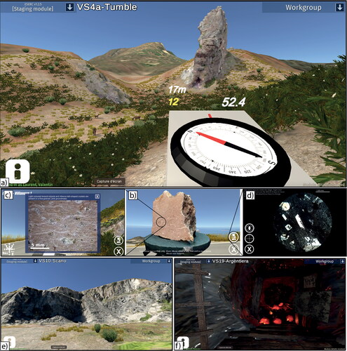
The virtual localities () were designed around those that would have been visited during the outdoor fieldwork with few exceptions and with the addition of some sites of geological interest that would not have been practical to visit in person (e.g., along busy road transects and underground). One such location was the Argentiera mine, which gave students experience of underground mapping in the mine’s tunnels. The VSF was delivered through lecture-style Microsoft Teams-led introductions and summaries, and independent work on the Virtual Sardinia App (VSA). The VSA consisted of a combination of Google Earth Street View-based localities, as well as 3D virtual environments created within the Unity game engine. These were compiled using photogrammetry and aerial drone footage collected on previous outdoor fieldwork. The virtual environment was a to-scale replication of the outcrops (), with a “virtual demonstrator” in the form of a game object with a prerecorded script. The Argentiera mine locality was created using underground maps of the tunnel system, sculpted tunnel parts textured using photographs of surface rocks at Argentiera, and an interpretation of the structure based on published literature and a cross-section constructed from field data (). As such, it was a locality designed to reproduce the style of mineralization rather than a replication of real-world data. Interaction with outcrop models was achieved using hotspot tools, enabling high-resolution models or images to be viewed, for example illustrating individual folds or lithologies. Certain hotspots also allowed students to see details of hand specimens and thin section imagery of specific samples using a virtual microscope, with the ability to swap between crossed and plane polarized light views on a rotating stage (). A virtual field toolbox was available for students to make measurements (compass and ruler). The compass was included as a dynamic model fixed to the camera so it always appeared in the field of view when activated ().
After the lecturer introductions, which set up particular geological inquiries and themes for each locality, students had independent time to explore the virtual environments and record their own observations through sketches, measurements and notes to form their personal interpretations. Students did not have the option to work in-app with their peers, but could communicate and share ideas through dedicated Microsoft Teams channels, for example sharing screenshots of their annotated sketches or discussing ideas on geological interpretations through voice and video calls. Students could also message lecturers and teaching assistants directly through private messaging on the Microsoft Teams app. Summaries were recorded live by the lecturer lead at the start of the next (UK) working day to accommodate different time zones.
The virtual South Wales and Scotland fieldwork (VSWSF)
The South Wales virtual fieldwork () was run from 17–24th September 2020, followed by the Scotland virtual fieldwork (, 28th September—6th October 2020). These virtual fieldwork were conducted for student cohort two () in replacement of the Spanish Pyrenees and Scotland outdoor fieldwork. The virtual fieldwork had similar learning objectives and assessment strategy as their on-location counterparts with a necessary change to the content: the outdoor Spanish Pyrenees fieldwork was replaced by the Virtual South Wales fieldwork. This was due to ease of outdoor field accessibility to collect additional data for the development of the virtual fieldwork.
Figure 2. The immersive and interactive three-dimensional Virtual South Wales Fieldwork. a, b, c) Examples of some of the virtual environments. Students were given the ability to fly to allow a better visualization of cliff outcrops than what can be seen on-location. The red square in b) highlights a glowing hotspot which contains a high-resolution picture of a closer view of the outcrop. The red arrows highlight the measuring tools that can be used to measure geological features in the virtual environment. Distance between the 2 points (12 m) is indicated at the bottom of the picture. d, e) Details of a high-resolution 3D model in Freshwater East where the plunge direction of flute casts can be measured to interpret paleo-flow directions.
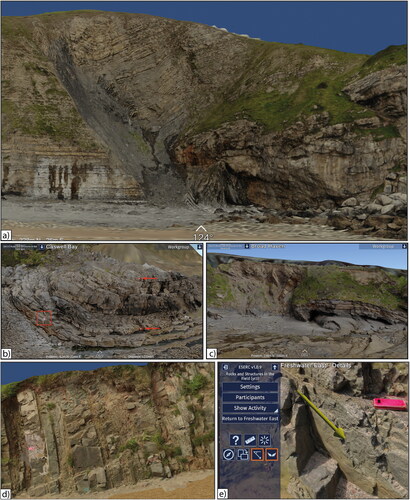
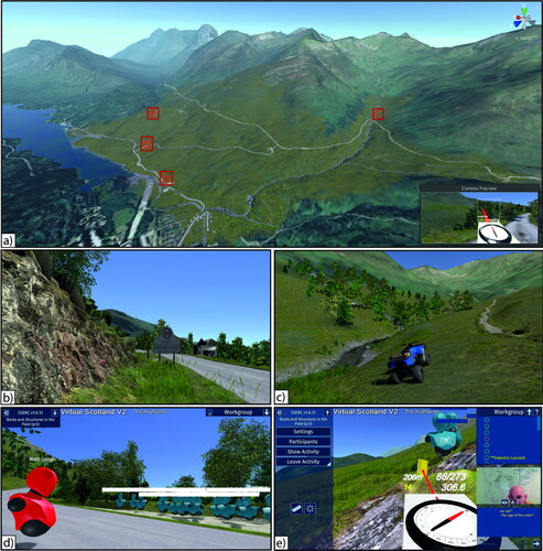
Figure 3. The immersive and interactive three-dimensional Virtual Scotland Fieldwork. a) Overview of the entire virtual environment (∼4km2) delimited by the yellow/brown grassy area. Location of is shown. b, c) A high degree of realism was included in the virtual world, including 30,000 trees, realistic rivers, road traffic and a quad bike used by students to traverse the area. d, e) enhanced live interactions between students (blue avatar) and lecturers (red avatar) and the possibility to see other avatars in the virtual environment. Students worked in small groups and could interact using either a chat function or directly via their microphone.
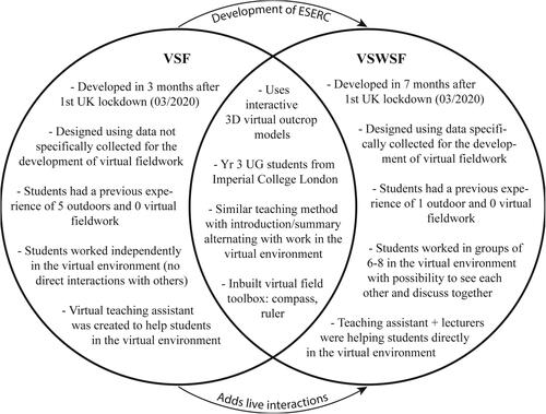
The structure of the virtual fieldwork was similar to their outdoor counterparts, starting with an introduction, followed by students working in the immersive virtual environment and finishing with a summary before moving to the next outcrop. However, major improvements were made to deliver this virtual fieldwork, with the development of a new in-house digital platform, ESERC (Earth Science and Engineering Remote Classroom, ). ESERC allows live voice/text discussions and collaborations, with students interacting in real-time as avatars in the virtual environment (). Students worked in groups of 6–8, and the virtual demonstrator of the VSF was replaced with live teaching assistants. Students could highlight an area of interest on-screen to others using a “ping” tool and use voice and text for live discussions on the ESERC platform (). Another difference compared to the VSF is that drone images and reconstructed 3D outcrop models were collected in the outdoor field specifically for the development of the VSWSF ().
Figure 4. Venn diagram showing similitudes and differences between the Virtual Sardinia Fieldwork (VSF) and the Virtual South Wales and Scotland Fieldwork (VSWSF).
The South Wales virtual fieldwork was based on separate virtual environments, each representing a different locality (). Digital 3D models of localities were set within surrounding landscape obtained from digital elevation models. This locality-based structure is common during outdoor fieldwork and is similar to the VSF. Students’ avatars were given the ability to “fly” in the virtual environment to be able to move rapidly from one outcrop to another, and to allow a better visualization of some of the outcrops (e.g., cliff outcrops, )).
The Scotland virtual fieldwork, in contrast, was intended to provide training in independent geological mapping and comprised a seamless virtual environment of 4 km2 of the Scottish Highlands in the vicinity of Kinlochleven (), replicating the area that is traditionally mapped during the outdoor Scotland fieldwork. The course featured 210 digital outcrops, allowing measurement of structural features using the virtual compass clinometer (), which was also improved further from the VSF with the ability to take dip and dip-direction measurements. A “laser-pointer” was added to the compass to allow the user to activate a measurement of the dip and dip-direction under the laser point (), whilst lineation plunge and plunge direction could be measured by rotating an arrow parallel to the lineation being measured (). To enable measurements to be made by sighting, a notebook that could be aligned with a planar feature was added. The notebook was activated and fixed with a button press and rotated with the arrow keys. The compass clinometer could then be used to take a measurement of the dip and dip-direction of the notebook (). These measurement methods were chosen to closely resemble the operation of a real compass clinometer to ensure that the skills learnt were as transferable to the real world as possible. A high degree of realism was included in the virtual world, including 30,000 trees, animated waterfalls, realistic rivers, road traffic and a quad bike used by students to traverse the area (). To better reproduce the outdoor field mapping experience, the ability to fly in the virtual environment was removed and students, via their avatars, had to walk (or run) at a realistic pace to explore the mapping area.
Research strategy
This study combines quantitative and qualitative data in a mixed-mode research strategy to compare the student learning experience during virtual and outdoor fieldwork. Students were surveyed on their attitudes to virtual fieldwork they had recently completed, and any outdoors fieldwork they had attended during their degree to date. Quantitative data were obtained via an anonymised survey that starts with a question on gender identification followed by a series of questions formatted as a symmetrical seven-point Likert scale (Appendix 1). This allowed participants to effectively rank a series of statements in order of their agreement (Bryman, Citation2008). The qualitative data were collected via three open-ended questions. The qualitative data were analyzed using thematic content analysis to identify the main categories of response to each question considering demographic information. This approach provided valuable insights from students’ narrative that gave further context for interpretations of the quantitative data. All questions in the survey were optional response.
The research team is composed of one undergraduate student who took part on the VSF (cohort one) and two academic faculty members who taught some of the outdoor fieldwork (one co-led the Spanish Pyrenees outdoor fieldwork and both led the Scotland outdoor fieldwork attended by students of cohort one, ). Both academics were involved in the design, development and teaching of the VSF and VSWSF. The questionnaire was designed by the student member of the research team using Qualtrics software (full questionnaire available in Appendix 1) and sent by email to all students who participated in the VSF and VSWSF. The email was sent by the undergraduate student from the research team to avoid power and influence issues. Students were surveyed within a week of completing their virtual fieldwork (May 2020 and October 2020).
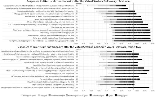
All students were contacted to take part in the survey. After the VSF, 26 students (12 female, 11 male, 1 nonbinary, 1 prefer not to say) out of 35 completed the questionnaire (student cohort one, ), a response rate of 74%. Eighteen students responded to the same questionnaire for the VSWSF (8 female, 9 male, 1 unknown) out of 28 (student cohort two, ), a response rate of 64%. The results are presented as diverging stacked bar charts ( and ; Robbins & Heiberger, Citation2011), and examples of student responses from the open-ended questions are included in the following results and discussion.
Figure 5. Diverging stacked bar chart of student responses to questionnaires on outdoors fieldwork experiences.
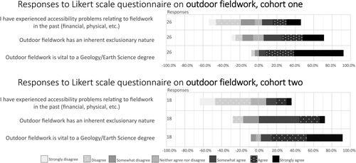
Figure 6. Diverging stacked bar chart of student responses to questionnaires on virtual fieldwork experiences.
Results
Attitudes to outdoor fieldwork
After the VSF, 50.0% of individuals who responded from student cohort one stated they have not faced accessibility problems (strongly to somewhat disagree) relating to outdoors fieldwork, compared to 42.3% agreeing they have to some extent (). The majority (92.3%) believed that outdoor fieldwork is essential to a degree in Earth Science, though 65.4% maintained that it has an inherently exclusionary nature to certain groups of people (). The open-ended answers showed that outdoor fieldwork is valued for the level of detail and engagement that can be gained from the field. Examples of student responses included claims that “you need to be able to see the geology with your own eyes in person to be able to fully understand the outcrop” and that “physical/outdoor fieldwork is more engaging… I [do] more of my own thinking.” One student described outdoor fieldwork as “real fieldwork,” that had “taught me at least as many skills as lectures.”
After the VSWSF, individuals who responded from student cohort two were in broad agreement with the responses from student cohort one on their attitudes to outdoor fieldwork. A larger overall percentage (72.2%) agreed that fieldwork was inherently exclusionary (). 27.8% had experienced accessibility problems, though 89% maintained outdoor fieldwork is vital to an Earth Science degree (). The open-ended answers showed students recognized barriers to participation for outdoor fieldwork, physically and mentally. One student surveyed remarked on the accessibility of outdoor fieldwork:
I strongly believe that fieldwork is inherently exclusionary. Those with accessibility issues are impacted in a wide range of ways whilst on outdoor fieldwork - from not being able to access all of the outcrops …and being made to feel embarrassed on account of something they can’t change.
There is a strong accessibility barrier in terms of the level of physical fitness required, allowing more physically able students to reach outcrops faster, and therefore have more time looking at them. In addition, more physically able students have less issues with fatigue affecting concentration.
Attitudes to virtual fieldwork
Virtual Sardinia fieldwork
Students from cohort one experienced some problems during the VSF such as i) technology issues (experienced by 42.3%), ii) difficulty in asking questions without a face-to-face discussion (experienced by 69.2%), and iii) a widely perceived (92.3%) sense that the nature of virtual fieldwork restricted the data that could be observed, measured and analyzed by students ().
The use of interactive 3D outcrop models was considered by most students of cohort one as a positive addition to the VSF (96.1%), with 92.3% finding that the balance between independent work in the virtual environment with lecture-led summaries was well managed (). Answers to open-ended questions suggested VSF students appreciated the role virtual fieldwork could play both during COVID-19 and in the longer term to facilitate accessibility for all. One response mentioned a student’s appreciation for “the benefits virtual fieldwork provides for those less able to do outdoor fieldwork,” and others highlighted that virtual fieldwork would be “particularly good for inaccessible/expensive areas [where] we would not otherwise do…fieldwork” and that it can be done “at any time, no time or price constraints.” However, less interaction with peers was cited as a barrier to engagement. Student responses included mentions of “dismal” audience participation and their experience of having “less interaction with friends [making it] harder to share ideas.”
Although a majority of students from cohort one (65.4%) would not prefer virtual fieldwork to be offered as an alternative to outdoor fieldwork, the same proportion thought that future fieldwork should contain virtual elements ().
Overall, just over half of students (52%) agreed that the VSF adequately replicated the experience they would have in the field, with a further 12% neither agreeing nor disagreeing ().
South Wales and Scotland virtual fieldwork
When it came to their virtual field experiences, students from cohort two that attended the VSWSF shared the consensus that the use of interactive 3D outcrop models was a positive addition to the fieldwork (83.3% - ). They also felt that demonstrators and lecturers were more available on the virtual fieldwork compared to outdoors (61.1%), in clear contrast to the students of cohort one (23.0% - ). There was less agreement with the statement “I felt I had less data available than I would in the field”, at 38.9% compared to 92.3% for VSF students. A higher percentage also agreed that they would like fully virtual fieldwork options in the future (38.9%) compared to 26.9% for student cohort one ().
In the open-ended answers, students from the VSWSF conveyed both issues they had with, and the benefits presented by, virtual fieldwork. A student mentioned the advantage of “no weather-related boundaries” and another appreciated the ability to “work on my own timetable and being able to go into the "field" whilst writing summaries/finalising maps” as “incredibly helpful.” However, students also commented on “limited amounts of high resolution imagery” making it difficult to “make any meaningful observations about lithology” and issues with “technological difficulties, time difference, and a lack of face to face questioning.” One student summarized their position as “physical fieldwork is a better and more memorable experience and I would always prefer it, but I do not believe my learning suffered in any way on the virtual trip.”
The value that the virtual fieldwork may play as a complement or alternative to outdoor fieldwork was also mentioned by a student who responded that virtual fieldwork “should be offered alongside actuall [sic] fieldwork for students that are unable to participate in the field.”
Overall, 72.2% of student cohort two agreed that the VSWSF adequately replicated the experience they would have in the field ().
Discussion
Interactive 3D virtual environments
Student responses clearly showed that 3D virtual environments provide a valuable learning experience, having the virtual app improved the field trip being the most agreed statement of both questionnaires (96.1% and 83.3% - ). As mentioned previously, virtual fieldwork may be prone to falling under the fieldtrip definition as laid out by Granshaw and Duggan-Haas (Citation2012), as by its nature students could not have as free rein over the virtual environment as they may have had in the outdoor field. Although this is the case to some degree with the VSF and VSWSF, with a portion of students agreeing that they had limited data at their disposal (though significantly less for the VSWSF, at 38.9%—), the VSF and VSWSF were innovative as they created immersive and interactive 3D virtual environments from field data (). The virtual environments were designed to be navigated in the first person and built to scale, allowing the student freedom to move around much like they would do in the field. A distinct innovation, compared to a purely Google Earth or presentation-based project, is that students could interact in more detail with the outcrops (), and features were designed to not guide to a single pre-determined answer. For example, by providing landscape view, 3D outcrops, rock samples, hand-lens scale close-ups, as well as microscopic views (), students could make field observations at different scales and develop their own multi-scale interpretations. Furthermore, the inclusion of 3D outcrops within a wider environment enabled spatial correlations between multiple localities engendering an inquiry-led approach to the learning experience (Bond & Cawood, Citation2021; Houghton et al., Citation2015).
For the VSWSF, students of cohort two were able to interact and work live in a group on ESERC ( and 4). This may have contributed to the greater consensus that virtual fieldwork adequately replicated the on-location field, as communication and idea-sharing is an important aspect of fieldwork (Henry & Murray, Citation2018).
The learning experience during virtual and outdoor fieldwork
Phrases like A virtual fieldtrip … shouldn’t be something that becomes the norm in the future., recorded in the open-ended questions, indicate there is a view amongst some students that virtual fieldwork is not a comparable exercise to outdoors fieldwork: student responses including the words real and actual when referring to on-location fieldwork imply by omission that virtual fieldwork is not, therefore, “real”. It is useful to discuss in this context the pedagogies of both outdoor and virtual fieldwork. Learning domains can be classified as cognitive, psychomotor and affective (Bloom & Krathwohl, Citation1957; Stokes & Boyle, Citation2009). Outdoor and virtual fieldwork vary in the extent to which learning can be supported within these domains, both having “positives” and “negatives” that are discussed below.
Cognitive domain of learning
Within the cognitive domain, the virtual fieldwork replicated outdoor fieldwork by using demonstrator summaries, in-app guided prompts, teaching assistants (only for student cohort two in the VSWSF, ) and the ability to view the geology at different scales (). Students generally agreed that the balance between independent and lecture-led work was good, suggesting the feasibility of developing independent understanding within the virtual environment. However, most students on the VSF (92.3%) also found that there was less data available to them than on outdoor fieldwork. This is considered an unavoidable feature of virtual fieldwork as it cannot provide full autonomy, and outcrop-level details are limited by resolution. However, for the VSWSF, students of cohort two were less likely to agree with this statement (38.9%), perhaps reflecting that data were collected specifically for the development of the virtual fieldwork (; Andrews, Citation2021). Furthermore, student cohort two had only once previously experienced outdoor fieldwork compared to three for student cohort one () and so had a smaller frame of reference of what is expected during outdoor fieldwork.
Virtual fieldwork does have the potential to support student understanding in ways that would not be possible with outdoor fieldwork, such as “flying” over an outcrop to have an overview of large-scale tectonic structures () or using a virtual microscope to study the mineralogy and microstructures of a specific sample (). Virtual fieldwork is not restricted by the logistics and safety restrictions inherent to outdoor fieldwork. For example, on the VSF students had the opportunity to study the Argentiera Mine and do underground geological mapping, an experience that for safety reasons could not be run in person (). Virtual fieldwork has fewer limits in this regard and presents new teaching and learning opportunities, such as visiting outcrops on both side of the Atlantic in a single session to study evidence of plate tectonic processes (Klippel et al., Citation2019), studying well-preserved deep oceanic submarine faults (Métois et al., Citation2021) or even visiting outcrops on other planets (Caravaca et al., Citation2020).
When considering the valid criticisms of the data available to students, it is important to place the VSF and VSWSF in the context of their creation. They were produced as an emergency response to the COVID-19 pandemic, being developed and delivered in a short timeframe, and for the VSF, with no opportunity to travel on-site and collect specific data. Instead, it had to be created based on incomplete data from previous years, which were not collected with the purpose of creating a fully virtual fieldwork experience (). Future virtual fieldwork design will benefit from more comprehensive preparation in the field, such as retrieving and 3D modeling more hand samples, and producing higher quality drone footage of localities. This difference is reflected already in the experiences of the VSWSF students.
Psychomotor domain of learning
The psychomotor, or kinesthetic, domain is fundamental to outdoor fieldwork as it involves handling rocks physically, using geological tools and equipment or moving around an outcrop to understand its formation and contextualize it within the surroundings. Common geological fieldwork tasks such as creating sedimentary logs for example, benefit from being able to see and touch rocks in situ to assess grain size and friability. By definition, the psychomotor domain of learning is very hard to replicate virtually. This was summarized in a student response, “you need to be able to see the geology with your own eyes in person to be able to fully understand the outcrop.”
However, the use of immersive virtual environments allows virtual fieldwork to reproduce some aspects of the outdoor fieldwork psychomotor domain of learning. For example, students were able to navigate around outcrops and to place geological information within a larger area. The main limitation is the resolution of the virtual environment, which often allows the observation of outcrop scale structures (e.g., bedding, foliation or large faults and folds) but not all the smaller-scale structures that would be observed in outdoor fieldwork. In the VSWSF, where students were able to see each other as avatars in the field, virtual students’ behavior that is common in the outdoor field was observed. For example, students’ avatars were mostly facing the lecturers’ avatars when they spoke, even though it is not necessary virtually. Students would also gather around lecturers during introduction and summary sessions, avoiding the road, despite the fact they could hear the summary session from wherever they were in the virtual environment (). Additionally, students were observed on several occasions jumping off waterfalls, going for a swim, taking photos and videos of what they did to post on social media at the end of the day. These behaviors are typical of what can be observed in outdoor fieldwork. So, even though virtual fieldwork will never be able to replicate every aspect of the outdoor field, it is interesting to note that students’ behavior can be similar in both outdoor and virtual fieldwork. These incidents of students spontaneously using environmental features for play during the field courses suggests a deeper physiological engagement with the virtual world and an enhanced level of immersion in the activity.
Affective domain of learning
Affective learning, which is related to emotional state, is often less appreciated within the sciences (Stokes & Boyle, Citation2009) yet may be crucial to a student’s learning experience during fieldwork (Eiss & Harbeck, Citation1969; Iozzi, Citation1989). For example, attitudes to outdoor fieldwork can be shaped by the weather, tiredness, stress over the availability of demonstrators or the time available at an outcrop (Giles et al., Citation2020; John & Khan, Citation2018; Stokes & Boyle, Citation2009). Some of these negative stressors are ameliorated by the nature of virtual fieldwork, such as the ability to revisit an outcrop in one’s own time, and the lack of weather issues in the virtual environment. Introductions and summaries were recorded during virtual fieldwork, helping to mitigate personal problems that may have prevented a student from being present during the live session. However, students also mentioned a lack of motivation (69.2% somewhat-strongly agree on VSF, 72.2% on VSWSF), and inability to ask questions without face-to-face interactions (69.2% and 50% respectively) as barriers to their learning.
The lack of motivation may be related to the nature of working remotely, with associated feelings of isolation from peers, even when students were able to have discussions in the virtual environment, making interactions more difficult. For example, a student can’t discuss with only one or two students when working virtually in a group of four or more—they need the confidence to speak in front of the entire group, which can be stressful and leads to a decrease in engagement. The fieldwork experience extends beyond mere visual interaction (Dolphin et al., Citation2019), with other sensory inputs providing an immersive “sense of place” which could be important to learning in the field, a form of embodied cognition (Shapiro & Stolz, Citation2019). This is closely related to both the psychomotor and cognitive domain, as physical interaction with the field environment acts as an aid to understanding and learning (Mogk & Goodwin, Citation2012). The atmosphere of fieldwork is difficult to replicate in the virtual sphere and responses to the questionnaire reveal student attitude in this respect, for example one student response stated that “real fieldwork is crucial … [it] develops a life-long love for geology.”
Yet, it is important not to conflate the issues of the “virtual” world with those due to the remote style of learning, which were necessary for course delivery during the COVID-19 pandemic. Problems such as communication barriers, poor Wi-Fi connection, unsuitable study spaces, or isolation are not fundamental or exclusive to virtual fieldwork but instead a by-product of distance-learning. Future virtual fieldwork could easily be run on campus, with lecturers and students in-person, overcoming both technological and collaboration issues. The VSWSF responses reflect the different experience the students had from being able to work collaboratively and interact live with teaching assistants: the majority of students thought demonstrators were more available than on outdoor fieldwork, compared to the VSF students who thought the opposite; and they were less likely to experience a communication barrier. Overall, a higher percentage of students on the VSWSF (student cohort two) felt that the experience adequately replicated the on-location field experience, at 72.2% compared to 52% on the VSF (student cohort one).
Student appreciation of fieldwork is often tied to being able to understand geological processes better through observation of their effects, putting skills learnt in class into practice, and learning field-specific techniques that may be useful in future careers (Payne, Citation2017). It is significant that the VSF and VSWSF were part of an UG year three, rather than an UG year one module. For students who have never been in the outdoor field before and have not learnt techniques such as using compass-clinometers, recording observations and how to draw accurate geological field sketches, or even had the opportunity to develop social and communication skills with peers in the outdoor field (Streule & Craig, Citation2016), virtual fieldwork similar to the VSF or VSWSF may not adequately replicate the essential learning objectives. Instead, specific virtual fieldwork can be developed with the objective of teaching basic geological field skills (e.g., Bursztyn et al., Citation2022). Most of these practical, field-specific skills are already well-established by the third year of an UG degree, where instead the focus for the VSF and VSWSF was on research-level fieldwork and more independent investigation.
Inclusivity
Though most of the analysis conducted examines the average student response, the entire range of student experiences is important to consider. One student who suffers exclusion still represents a person who cannot access the same level of field experience as their peers. For instance, in response to the question “I would prefer a fully virtual fieldtrip to be an offered alternative to outdoor fieldtrips in the future”, 31.8% (fourteen individuals across both student cohorts) agreed, of which 9.1% (four individuals) strongly agreed. These data represent students who feel that virtual fieldwork positively benefited their learning experience compared to outdoor fieldwork. For a student of cohort one, the VSF was a unique opportunity to engage with fieldwork (as reported by Wilkes & Dobb, Citation2020):
Despite a lot of students feeling disappointed that they couldn’t travel to Sardinia on a field trip, I was very excited that the trip had become virtual. I have a disability which means I can’t normally attend fieldwork, so the experience has been extra special for me. […] This is the first fieldwork I have been able to attend since fresher’s week in my first year, and I’ve loved every minute of it. I feel like I’ve learnt so much, and it’s been great to be able to apply what I have learnt in lectures to real-life examples in the field – which is exactly what fieldwork is about, but normally I wouldn’t get that opportunity.
Implications
Pedagogical design for inclusivity
The pedagogical design of accessible fieldwork should consider multiple means of access, and flexibility of delivery (Houghton et al., Citation2020; Stokes et al., Citation2019). Accessibility does not exist as a binary, as neither does disability, financial situation, physical or mental health or any of the many factors that can impact students’ relationship with fieldwork (Stokes et al., Citation2019). Students who may have “slightly disagreed” or “somewhat agreed” with statements about accessibility may have different perceptions of what may be considered a barrier. Inclusivity issues with fieldwork can’t be fully resolved, however, the nature of outdoor fieldwork as it currently exists does have the capacity to become more accessible (Atchison et al., Citation2019; Carabajal et al., Citation2017; Giles et al., Citation2020; Gilley et al., Citation2015; Houghton et al., Citation2020; Petcovic et al., Citation2014; Stokes et al., Citation2019; Whitmeyer & Dordevic, Citation2021). Problems surrounding outdoor fieldwork are not exclusive to the COVID-19 pandemic, though it can be used as a catalyst for reevaluating how fieldwork is approached. The global pandemic has provided an opportunity to reflect on redesigning fieldwork education in the future, as well as impetus for the design of virtual fieldwork opportunities.
Implementation of virtual fieldwork in the curriculum
The questionnaire found that most of the students considered virtual fieldwork worthwhile and would like future fieldwork to incorporate virtual components. Virtual fieldwork can be used in geoscience curricula to complement outdoor fieldwork programs. For example, virtual elements could be used prior to outdoor fieldwork to give students an idea of the geology they will see in the field. This could allow for more efficient use of time and learning in the field, as students have a clearer idea of their learning objectives (Streule & Craig, Citation2016). By shrinking their novelty spaces, students can enter the field with more confidence and approach their learning more efficiently (Stokes et al., Citation2019). Virtual fieldwork could also be undertaken after outdoor fieldwork, for example where there are cost, time, safety or logistical constraints to in-person visits such as with the Argentiera Mine in Sardinia, or to revisit localities as part of a synthesis exercise.
An interesting future application of virtual environments in the geosciences is in the creation of short virtual field activities delivered to provide enhanced practical learning experiences with no logistical overhead. Several of these short virtual field visits were conducted as part of other courses during the pandemic, with students “visiting” Etna and Santorini for hour-long activities immediately after lectures. Short virtual learning activities also provide the opportunity to demonstrate processes that cannot be observed in the real world, for example, in the Santorini activity students experienced a recreation of the Minoan eruption of 1620 BC.
A limitation of this study is that the VSF and VSWSF are not publicly available as they were not designed for it and delivered via the in-house ESERC platform. However, the two main outcomes of our study are, i) virtual fieldwork taught using interactive and immersive 3D virtual environments can adequately replicate the outdoor fieldwork learning experience, and ii) such virtual fieldwork has the potential to improve inclusivity in geosciences degrees. These outcomes are not specific to the virtual fieldwork described in this study but can be achieved via teaching of any other virtual fieldwork taught using interactive and immersive 3D virtual environment models. We recognize that not every geosciences department has the resources and expertise to develop themselves their own interactive three-dimensional virtual fieldwork but there are some other examples available to the community already, especially since the COVID-19 pandemic (e.g., Bond & Cawood, Citation2021; Harknett et al., Citation2022; Needle et al., Citation2022; Tibaldi et al., Citation2020; see also virtual outcrop databases like V3Geo, eRocK, Sketchfab). And these are likely to develop rapidly in the future.
In the changing landscape of geosciences, as the subject faces issues with diversity, falling student enrollment (Giles et al., Citation2020) and major changes in environmental-related industries, the nature of fieldwork must adapt. For geosciences to become more inclusive and to reflect these changes, high-quality and field-equivalent virtual fieldwork should be available in supplement to outdoor fieldwork in the curricula. In the specific example of the UK, this study suggests that virtual fieldwork should be considered as an alternative to at least some, if not all, of the required field days for accredited Earth Science degrees. This is not a suggestion that outdoor fieldwork has no place in a geoscience degree; to the contrary, our results show that outdoor fieldwork is valued amongst students and still provides unique pedagogical perspectives, teaching students field-specific skills that cannot be easily replicated virtually. Rather, well-designed immersive and interactive 3D virtual fieldwork should be seriously considered as a legitimate supplement to outdoor fieldwork, for the countless opportunities that virtual fieldwork can open in terms of the teaching and learning experience and with an aim of increasing inclusivity in geosciences education.
Conclusions
The virtual fieldwork presented in this study (VSF and VSWSF) were innovative as they directly attempted to address issues and opportunities presented by virtual fieldwork. By creating a fully realized field environment completed with hand-specimen models, ancillary details such as a virtual microscope and the ability to fly and see outcrops from a much wider frame of view, students were given the opportunity to generate their own geological hypotheses based on real field data without being guided to pre-determined conclusions. This was balanced with the use of live summaries, allowing students to have direct contact with lecturers. For VSWSF, this was expanded upon, with teaching assistants and lecturers present throughout within the virtual environment.
This study shows that students recognize the importance of outdoor fieldwork but find it inherently exclusionary. Students value the practical application of theoretical skills and the inquiry-led autonomy of outdoor fieldwork. During virtual fieldwork, lack of face-to-face interactions and technological related issues were cited as obstructions to learning. However, students faced reduced financial and physical barriers, and enjoyed greater flexibility of working hours. Student responses indicate that virtual fieldwork taught using interactive three-dimensional virtual outcrop models adequately replicated the outdoor fieldwork learning experience. Students also recognize that virtual fieldwork removed some of the barriers inherent to outdoor fieldwork. However, a large majority of students enjoy going in the outdoor field and would not like to see virtual fieldwork fully replacing outdoor fieldwork in the future.
Even if most students can and will willingly participate in outdoor fieldwork again, this is not true for every student and personal situations can change. Fieldwork should be able to impart benefits to students regardless of their circumstances. For these reasons, this study recommends that design of fieldwork in geoscience curricula at university should include virtual components that could be used before, during and after outdoor fieldwork. We also encourage the development of immersive and interactive 3D virtual fieldwork for students that are unable to participate in outdoor fieldwork with the aim to increase inclusivity.
Supplemental Material
Download MS Word (436.2 KB)Acknowledgments
The authors would like to thank Dr Mark Sutton, Dr Alex Whittaker and Dr Alan Spencer who helped developing and delivering virtual fieldwork. The authors are also grateful to the Education Ethics Review Committee who made pertinent remarks and comments before granting ethics approval for this research project. Fruitful discussions with students of the RAISE-Imperial Group as well as with Dr Alison Stokes, Dr Cedric John and Dr Saira Khan contributed to the improvement of earlier versions of this manuscript. Finally, we thank Kimberly Hannula for careful and constructive editorial handling and Steve Whitmeyer, Alison Jolley and two anonymous reviewers for insightful and helpful reviews that helped to considerably improve the manuscript.
Disclosure statement
The authors report there are no competing interests to declare.
References
- Andrews, R. (2021). Using video game tech to teach field-starved geology students. Atlas Obscura. https://www.atlasobscura.com/articles/virtual-geology-field-work
- Atchison, C. L., Marshall, A. M., & Collins, T. D. (2019). A multiple case study of inclusive learning communities enabling active participation in geoscience field courses for students with physical disabilities. Journal of Geoscience Education, 67(4), 472–486. https://doi.org/10.1080/10899995.2019.1600962
- Bloom, B., & Krathwohl, D. (1957). Taxonomy of educational objectives: the classification of educational goals. Handbook 1. Committee of College and University Examiners, Benjamin S. Bloom. The Elementary School Journal, 57, 343–344. https://doi.org/10.1086/459563
- Bond, C. E., & Cawood, A. J. (2021). A role for virtual outcrop models in blended learning – improved 3D thinking and positive perceptions of learning. Geoscience Communication, 4(2), 233–244. https://doi.org/10.5194/gc-4-233-2021
- Boyle, A., Maguire, S., Martin, A., Milsom, C., Nash, R., Rawlinson, S., Turner, A., Wurthmann, S., & Conchie, S. (2007). Fieldwork is good: The student perception and the affective domain. Journal of Geography in Higher Education, 31(2), 299–317. https://doi.org/10.1080/03098260601063628
- Bryman, A. (2008). Social research methods (3rd ed.). Oxford University Press.
- Buckley, S. J., Howell, J. A., Naumann, N., Pugsley, J., Vanbiervliet, J., Ringdal, K., Lewis, C., Tong, B., & Chmielewska, M. (2022, April). Virtual field trips: Experience from a global pandemic and beyond [Paper presentation]. SPE Norway Subsurface Conference. OnePetro. https://doi.org/10.2118/209560-MS
- Bursztyn, N., Sajjadi, P., Riegel, H., Huang, J., Wallgrün, J. O., Zhao, J., Masters, B., & Klippel, A. (2022). Virtual strike and dip–advancing inclusive and accessible field geology. Geoscience Communication, 5(1), 29–53. https://doi.org/10.5194/gc-5-29-2022
- Carabajal, I. G., Marshall, A. M., & Atchison, C. L. (2017). A synthesis of instructional strategies in geoscience education literature that address barriers to inclusion for students with disabilities. Journal of Geoscience Education, 65(4), 531–541. https://doi.org/10.5408/16-211.1
- Caravaca, G., Le Mouélic, S., Mangold, N., L’Haridon, J., Le Deit, L., & Massé, M. (2020). 3D digital outcrop model reconstruction of the Kimberley outcrop (Gale crater, Mars) and its integration into Virtual Reality for simulated geological analysis. Planetary and Space Science, 182, 104808. https://doi.org/10.1016/j.pss.2019.104808
- De Paz-Álvarez, M. I., Blenkinsop, T. G., Buchs, D. M., Gibbons, G. E., & Cherns, L. (2021). Virtual fieldtrip to the Esla Nappe (Cantabrian Zone, NW Spain): Delivering traditional geological mapping skills remotely using real data. Solid Earth, 13(1), 1–14. https://doi.org/10.5194/se-2021-110
- Dolphin, G., Dutchak, A., Karchewski, B., & Cooper, J. (2019). Virtual field experiences in introductory geology: Addressing a capacity problem, but finding a pedagogical one. Journal of Geoscience Education, 67(2), 114–130. https://doi.org/10.1080/10899995.2018.1547034
- Eiss, A. F., & Harbeck, M. B. (1969). Behavioral objectives in the affective domain.
- Elkins, J. T., & Elkins, N. M. (2007). Teaching geology in the field: Significant geoscience concept gains in entirely field-based introductory geology courses. Journal of Geoscience Education, 55(2), 126–132. https://doi.org/10.5408/1089-9995-55.2.126
- Giles, S., Jackson, C., & Stephen, N. (2020). Barriers to fieldwork in undergraduate geoscience degrees. Nature Reviews Earth & Environment, 1(2), 77–78. https://doi.org/10.1038/s43017-020-0022-5
- Gilley, B., Atchison, C., Feig, A., & Stokes, A. (2015). Impact of inclusive field trips. Nature Geoscience, 8(8), 579–580. https://doi.org/10.1038/ngeo2500
- Granshaw, F., & Duggan-Haas, D. (2012). Virtual fieldwork in geoscience teacher education: Issues, techniques and models. In S. Whitmeyer, J. E. Bailey, D. G. De Paor, and T. Ornduff (Eds.), Google earth and virtual visualizations in geoscience education and research (1st ed., pp. 285–303). Geological Society of America.
- Hall, T., Healey, M., & Harrison, M. (2004). Fieldwork and disabled students: Discourses of exclusion and inclusion. Journal of Geography in Higher Education, 28(2), 255–280. https://doi.org/10.1080/0309826042000242495
- Harknett, J., Whitworth, M., Rust, D., Krokos, M., Kearl, M., Tibaldi, A., Bonali, F. L., Van Wyk de Vries, B., Antoniou, V., Nomikou, P., Reitano, D., Falsaperla, S., Vitello, F., & Becciani, U. (2022). The use of immersive virtual reality for teaching fieldwork skills in complex structural terrains. Journal of Structural Geology, 163, 104681. https://doi.org/10.1016/j.jsg.2022.104681
- Henry, T., & Murray, J. (2018). How does it feel? The affective domain and undergraduate student perception of fieldwork set in a broad pedagogical perspective. Tuning Journal for Higher Education, 5(2), 45–74. https://doi.org/10.18543/the-5(2)-2018pp45-74
- Hopkins, C. (2019). Virtual reality geology field trips. GEO ExPro. https://www.geoexpro.com/articles/2019/03/virtual-reality-geology-field-trips.
- Houghton, J. J., Lloyd, G. E., Robinson, A., Gordon, C. E., & Morgan, D. J. (2015). The Virtual Worlds Project: Geological mapping and field skills. Geology Today, 31(6), 227–231. https://doi.org/10.1111/gto.12117
- Houghton, J. J., Morgan, D. J., Gordon, C. E., Stokes, A., Atchison, C. L., Collins, T. D., Craven, B., & Willis, K. (2020). Access Anglesey 2018: Lessons from an inclusive field course. Advances in Geosciences, 53, 183–194. https://doi.org/10.5194/adgeo-53-183-2020
- Hughes, A. (2016). Exploring normative whiteness: Ensuring inclusive pedagogic practice in undergraduate fieldwork teaching and learning. Journal of Geography in Higher Education, 40(3), 460–477. https://doi.org/10.1080/03098265.2016.1155206
- Hurst, S. (1998). Use of “virtual” field trips in teaching introductory geology. Computers & Geosciences, 24(7), 653–658. https://doi.org/10.1016/S0098-3004(98)00043-0
- Iozzi, L. A. (1989). What research says to the educator: Part one: Environmental education and the affective domain. The Journal of Environmental Education, 20(3), 3–9. https://doi.org/10.1080/00958964.1989.9942782
- John, C., & Khan, S. (2018). Mental health in the field. Nature Geoscience, 11(9), 618–620. https://doi.org/10.1038/s41561-018-0219-0
- Jones, R. R., McCaffrey, K. J. W., Clegg, P., Wilson, R. W., Holliman, N. S., Holdsworth, R. E., Imber, J., & Waggott, S. (2009). Integration of regional to outcrop digital data: 3D visualisation of multi-scale geological models. Computers & Geosciences, 35(1), 4–18. https://doi.org/10.1016/j.cageo.2007.09.007
- Klippel, A., Zhao, J., Jackson, K. L., La Femina, P., Stubbs, C., Wetzel, R., Blair, J., Wallgrün, J. O., & Oprean, D. (2019). Transforming earth science education through immersive experiences: Delivering on a long held promise. Journal of Educational Computing Research, 57(7), 1745–1771. https://doi.org/10.1177/0735633119854025
- Madden-Nadeau, A. L., & Genge, M. J. (2019). Fiamme degassing structures and their implications for the post-emplacement temperatures and H2O contents of high-grade ignimbrites. Journal of Volcanology and Geothermal Research, 384, 251–262. https://doi.org/10.1016/j.jvolgeores.2019.08.003
- Métois, M., Martelat, J.-E., Billant, J., Andreani, M., Escartín, J., & Leclerc, F. (2021). Deep oceanic submarine fieldwork with undergraduate students: An immersive experience with the Minerve software. Solid Earth, 12(12), 2789–2802. https://doi.org/10.5194/se-12-2789-2021
- Mogk, D. W., & Goodwin, C. (2012). Learning in the field: Synthesis of research on thinking and learning in the geosciences. In K. A. Kastens and C. A. Manduca (Eds.), Earth and mind II: A synthesis of research on thinking and learning in the geosciences (Vol. 2, pp. 131–164). Special Paper 486. The Geological Society of America.
- Munge, B., Thomas, G., & Heck, D. (2018). Outdoor fieldwork in higher education: Learning from multidisciplinary experience. Journal of Experiential Education, 41(1), 39–53. https://doi.org/10.1177/1053825917742165
- Needle, M. D., Mooc, J., Akers, J. F., & Crider, J. G. (2022). The Structural Geology Query Toolkit for digital 3D models: Design custom immersive virtual field experiences. Journal of Structural Geology, 163, 104710. https://doi.org/10.1016/j.jsg.2022.104710
- Payne, R. (2017). Fieldwork is good … but why? North West Geography, 17(1), 1–11.
- Peace, A. L., Gabriel, J. J., & Eyles, C. (2021). Geoscience fieldwork in the Age of COVID-19 and beyond: Commentary on the development of a virtual geological field trip to Whitefish Falls, Ontario, Canada. Geosciences, 11(12), 489. https://doi.org/10.3390/geosciences11120489
- Petcovic, H., Stokes, A., & Caulkins, J. (2014). Geoscientists’ perceptions of the value of undergraduate field education. GSA Today, 24(7), 4–10. https://doi.org/10.1130/GSATG196A.1
- Pugsley, J. H., Howell, J. A., Hartley, A., Buckley, S. J., Brackenridge, R., Schofield, N., Maxwell, G., Chmielewska, M., Ringdal, K., Naumann, N., & Vanbiervliet, J. (2022). Virtual field trips utilizing virtual outcrop: Construction, delivery and implications for the future. Geoscience Communication, 5(3), 227–249. https://doi.org/10.5194/gc-5-227-2022
- Robbins, N., & Heiberger, R. (2011). Plotting likert and other rating scales. In Proceedings of the 2011 Joint Statistical Meeting (pp. 1058–1066). American Statistical Association.
- Shapiro, L., & Stolz, S. A. (2019). Embodied cognition and its significance for education. Theory and Research in Education, 17(1), 19–39. https://doi.org/10.1177/1477878518822149
- Shulman, L. S. (2005). Signature pedagogies in the professions. Daedalus, 134(3), 52–59. https://doi.org/10.1162/0011526054622015
- Stokes, A., & Boyle, A. P. (2009). The undergraduate geoscience fieldwork experience: Influencing factors and implications for learning. In S. J. Whitmeyer, D. W. Mogk, and E. J. Pyle (Eds.), Field geology education: Historical perspectives and modern approaches (Vol. 461, p. 291). Special Paper 461. The Geological Society of America.
- Stokes, A., Feig, A., Atchison, C., & Gilley, B. (2019). Making geoscience fieldwork inclusive and accessible for students with disabilities. Geosphere, 15(6), 1809–1825. https://doi.org/10.1130/GES02006.1
- Streule, M., & Craig, L. (2016). Social learning theories—An important design consideration for geoscience fieldwork. Journal of Geoscience Education, 64(2), 101–107. https://doi.org/10.5408/15-119.1
- Tibaldi, A., Bonali, F. L., Vitello, F., Delage, E., Nomikou, P., Antoniou, V., Becciani, U., de Vries, B. V. W., Krokos, M., & Whitworth, M. (2020). Real world–based immersive Virtual Reality for research, teaching and communication in volcanology. Bulletin of Volcanology, 82(5), 1–12. https://doi.org/10.1007/s00445-020-01376-6
- Whitmeyer, S. J., & Dordevic, M. (2021). Creating virtual geologic mapping exercises in a changing world. Geosphere, 17(1), 226–243. https://doi.org/10.1130/GES02308.1
- Wilkes, H., & Dobb, E. M. (2020). Sampling Sardinia on screen – imperial engineering. https://blogs.imperial.ac.uk/engineering/2020/05/29/sampling-sardinia-on-screen/