
Abstract
A contemporary trend in glacial geomorphology is the quest for a unifying theory of drumlin and ribbed moraine formation. Three Swedish example areas of each are here newly mapped, using high-resolution Light Detecting and Ranging (LiDAR) data. From previous ribbed moraine studies in these areas, we know that they formed differently, one by melt-out of stagnant debris-zonated ice, another by remoulding of pre-existing landforms and the third by active subglacial stacking and folding of sediment into proto ridges, contemporaneously with lee-side cavity sediment infill. Through previous work on streamlined terrain in Sweden we know that rock-cored drumlins dominate, while soft-cored drumlins are much less common. The morphology of both types varies along a continuum, whereas their processes of formation differ. Our field examples from ribbed moraine tracts and streamlined terrain suggest that the subglacial environment contains a suite of different ice-sediment physics that, irrespective of this, leads to an equifinality of shape of some subglacial landforms (ribbed moraine and streamlined terrain) despite the differences in the detail of their process of formation. We thus argue that different processes, on their own or in combination, lead to a similar form of morphometric expression, that is, equifinality, and the quest for a unifying process of formation is a misleading one. Furthermore, we argue that large morphological data-sets of subglacial landforms can only be used to classify features as part of a formation continuum – or not – when they are used in conjunction with the sedimentology of said landforms.
Introduction
Parallel and transverse to ice-flow landforms on the palaeobeds of former ice sheets are used as both flow-direction indicators and flow-state diagnostic criteria. These landforms range from flutes to drumlins and megaflutes through Megascale Glacial Lineations (MSGLs) to ribbed moraine. This is a division mainly based on landform morphology. Research papers dealing with their formation – which often describe and take into consideration morphological, architectural and/or sedimentological properties in restricted geographical areas – are numerous [see reviews in, e.g., Menzies (Citation1979) and Stokes et al. (Citation2011)] and often arrive at very different conclusions about the glacial processes at work during their formation. A classic remark on this situation regarding drumlin formation is the one by Sugden & John (Citation1976, p.239): “there are almost as many theories of drumlin formation as there are drumlins”. The implied problem with this is, however, only a problem if, as a basic premise, drumlins form by just one process.
A clear trend in the glacial geomorphology research of the last decades is the quest for a single process theory that explains the formation of all ribbed moraine areas and all drumlins and, in this endeavour, also a unifying theory that explains the formation of both in a single context. This is because these landforms are regarded by many geomorphologists as end members in a bedform system with transitional geomorphic expressions in between. An often used analogue to this is the fluvial depositional environment with a bed system of flat beds – transverse dunes – longitudinal dunes or to aeolian environments with the formation of longitudinal and transverse dunes as bedform end members. The bedform approach, which argues that drumlins and ribbed moraine belong to a transitional size and shape continuum formed at the ice–bed interface, stems from early papers by Lundqvist (Citation1969, Citation1970) and Aario (Citation1977), suggesting such a relation. There has been an explosive revival of morphometric studies during the last decades, fuelled in part by the Light Detecting and Ranging (LiDAR) revolution (e.g., Johnson et al. Citation2015; Ojala & Sarala Citation2017). The measuring of length, width and height relations together with other morphological parameters such as wavelengths in ribbed moraine tracts (Dunlop et al. Citation2008; Chapwanaya et al. Citation2011), and carried out on large data-sets, has increasingly stressed the size and shape continuum of drumlins and ribbed moraine (e.g., Rose & Letzer Citation1977; Everest et al. Citation2005; Clark et al. Citation2009; Clark Citation2010; Spagnolo et al. Citation2014; Ely et al. Citation2016). Such studies suggest that metrics measured on both drumlins (e.g., Ely et al. Citation2016) and ribbed moraine (e.g., Dunlop et al. Citation2008) plot as unimodal distributions, argued to be indicative of “a single formational mechanism which operated widely at the base of these ice sheets” (Dunlop et al. Citation2008, p.2), while if the same landforms have different process-driven backgrounds, their metrics should plot in separate clusters (Ely et al. Citation2016).
One of these proposed unifying theories is the Bed Ribbing Instability Explanation, originally formulated from mathematical calculations by Hindmarsh (Citation1998a, Citation1998b, Citation1999) on sub-ice/bed interface sediment deformation, further developed in the works of Fowler (Citation2000), Schoof (Citation2007), Chapwanaya et al. (Citation2011) and Fannon et al. (Citation2017). Their numerical model simulations produce planform patterns that mirror the “real world” shape and size of drumlins and, especially, ribbed moraine. This theory has been evolved by the works of Dunlop et al. (Citation2008), Clark (Citation2010) and Stokes et al. (Citation2013) into the “instability theory”, emphasising the role of constructional deformation of subglacial sediment into emerging drumlins and ribbed moraine tracts, seen as perturbations over the ice–bed interface that grow with time. A variant to the driving forces for the emergence of drumlins from small-scale bed perturbations is forwarded by Hooke & Medford (Citation2013), suggesting that drumlins could be a product of thermo-mechanical instability at the ice–bed interface caused by a patch-work of frozen spots within a melted bed, at which there is mainly erosion over melted bed areas with erosion forming inter-drumlin troughs, while the frozen spots are areas with net deposition of stabilized deforming till, which are the emerging drumlin ridges. However, this drumlin-forming process is not argued to be a universal solution to drumlin formation; Hooke & Medford (Citation2013) clearly state their view that drumlins form in different ways depending on the physical background.
The instability theory is, however, not the only single process or unifying theory of subglacial bedform formation available. A recent competitor is the “erodent layer hypothesis” (ELH) by Eyles et al. (Citation2016), which argues that all drumlins form due to erosion performed by a deforming layer beneath the ice–bed interface, cutting into pre-existing sediments. The formation of ribbed moraine is, however, not a part of this bedform-formative theory. An older unifying theory of drumlin and ribbed moraine formation is that of the “Shaw school” (Shaw Citation1983a, Citation1994; Shaw & Kvill Citation1984; Shaw & Sharp Citation1987; Shaw et al. Citation1989, Citation2000, Citation2008; Fisher & Shaw Citation1991), emphasising subglacial meltwater flooding as the acting agent. The flooding theory suggests that drumlins and ribbed moraine formed from sediment deposition into cavities parallel or transverse to the water flow; these cavities are argued to have been eroded upwards into the ice roof and later acting as sediment traps during waning flow The subglacial flooding theory also suggests that formation of depositional drumlins can be combined with erosion by meltwater vortices down into existing sediment, leaving behind drumlins as erosional remnants.
This said, based on field evidence on the internal composition and architecture and the internal relation to the exterior form, that is, the shape of drumlins or ribbed moraine, many glacial sedimentologists have argued that it is instead a number of different processes on their own or in combination that lead to a similar form, that is, equifinality, in spite of the different processes that formed them. Cleland (Citation2013) discusses, from a philosophical point of view, the concept of a common (single) cause explanation of geologic observations and exemplifies that with, for example, mass extinctions through geologic time, arguing that there is a most probable common cause explanation for the K/T boundary extinction (massive meteorite impact on Earth) but that this cannot be taken as an explanation for every other mass extinction detected though deep geological time (there are probably multiple causes behind all mass extinctions). The parallel to our Quaternary enigma is that there can of course be a single common cause that explains a specific drumlin flow set or ribbed moraine tract (which is then a particular case), but that does not have to be the explanation for another set. This is particularly the case if the features have very different sedimentological and/or structural attributes. In turn, this leads to the argument that the cause of the particular case cannot be used to explain the general case, that is, the formation of all drumlins or all ribbed moraine over glaciated terrain on the globe.
The “instability theory” is argued to be a “common cause explanation” for all drumlin (Stokes et al. Citation2013) and ribbed moraine (Dunlop et al. Citation2008; Chapwanaya et al. Citation2011) formation at former ice sheet beds. The physics behind the instability theory implies that sediment (till) deforming below the ice–bed interface is redistributed into the landforms in question, growing over time due to a bed perturbation caused by “instability”. Then, not only must the outputs from process-based numerical simulation models conform to the real-world morphological expression of drumlin flow sets and ribbed moraine tracts to prove correctness, which has been achieved by comparisons with the extensive mapping of streamlined terrain and ribbed moraine (e.g., Dunlop & Clark Citation2006; Clark et al. Citation2009; Stokes et al. Citation2013; Spagnolo et al. Citation2014; Dowling et al. Citation2015). The validity of the instability theory must also be supported by observation on the landforms interiors. As the model predicts sediment deposition from a deforming bed – the prerequisite for the instability theory – below the ice–bed interface, this should be detectable from careful sedimentological studies of the landforms’ internal sediment composition and their sediment architecture. This is, however, poorly tested. Stokes et al. (Citation2013) do provide a series of explanations for how instability theory can result in the commonly seen variants of internal drumlin composition. Whilst they are logical, the explanations given have yet to be conclusively proved and do not apply to the sedimentology seen inside ribbed moraine.
In the rest of this paper, we concentrate on the formation of ribbed moraine, but also touch upon drumlin formation. We do this via a review of published sedimentological case studies on ribbed moraine from different parts of Sweden as well as three case studies on drumlins from various parts of Sweden, with an intent to evaluate how supportive – or not – they are of the instability theory as a “common-cause” explanation for all ribbed moraine (and streamlined terrain) formation. The key questions that we seek to answer here are as follows: Is the formation of ribbed moraine tracts (and streamlined terrain) polygenetic or monogenetic? And to what degree does “equifinality” play a role in glacial landform formation?
Methods
LiDAR and digital surface models
Sweden’s ‘Nationell Höjdmodell’ (National Height model), produced by the Swedish national mapping agency (Lantmäteriet; http://www.lantmateriet.se), uses LiDAR (see technical description in Dowling et al. Citation2013) with an average vertical accuracy of ~0.1 m and a pixel resolution of 2 m. The data are pre-processed to remove both forest cover and urban areas down to “true” ground level. Hill-shade models for areas presented in this paper were produced with the software package ArcGIS10 with illumination azimuths set to the best shadow effect on the objects in question. The digital surface models (DSMs) were first colour shaded in a graded scale from highest to lowest elevation values (hypsometric tint) and then draped with a transparent hill shade with the angle of illumination set to 40° and a vertical exaggeration (z) of 5.
Ribbed moraine was mapped from a combination of the hill shades and contours (2-m intervals) generated from the DSMs. One individual carried out the mapping in order to ensure that if any mapping biases were present in the mapper’s technique, the bias would be consistent (Smith & Clark Citation2005). Each feature was examined from two illumination angles and a polygon was drawn around the break of slope at the base of each feature. If there were compound features and no break of slope was present between the two elements, the landform was mapped as one feature. Another individual then crosschecked the mapping, but the interpretation was only altered if both mappers were in agreement with the revisions.
Ribbed moraine morphometrics were produced from the mapped polygons following a modified version of the methods outlined in Spagnolo et al. (Citation2010, 2012). Height is found by the same method as described by Spagnolo et al. (Citation2012) and is therefore the height of a feature above a plane generated from the elevation value of the mapped break of slope that defines said feature. Zonal statistics are applied to find the maximum height above the plane and this is the value reported.
Length and width were found by fitting a convex hull minimum-bounding geometry (MBG) polygon to each mapped feature. The convex hull was selected as the method of finding the length and width, as the rectangular MBG applied by Spagnolo et al. Citation(2010) performs poorly on features with significant curvature or sinuosity. By fitting a convex hull, we achieve the closest possible fit of a simplified polygon whilst maintaining the key characteristics of the shape (Toussaint & Avis Citation1982). The reported length is therefore the longest axis of this simplified shape and the reported width is the longest axis that is perpendicular to the length axis. However, due to the simplification of the shape, this technique will produce values that are potentially an underestimation of length compared to previous work that has the manually measured length as the full length of the ridge, following the complete curvature of the ridge (c.f. Dunlop & Clark Citation2006). This underestimation is considered acceptable due to the increase in analytical speed that it provides and given that it better describes the space that is occupied by the feature. This is as opposed to incorporating both the space occupied by a feature and its sinuosity as per a full-length measurement. In addition to these benefits, the metrics remain internally consistent throughout as the potential for human measurement error is greatly reduced and the longest perpendicular axis is always found.
The derived metrics are statistically evaluated and plotted using the Python libraries Scipy (Oliphant Citation2007), Numpy (van der Walt et al. Citation2011), Pandas (McKinney Citation2010) and Matplotlib (Hunter Citation2007) in Python 3.6. Each location’s metrics are plotted and normalised separately in order to maintain each population as a separate entity. Of the summary statistics, modal and mean values are not the most useful for comparison between sites (Hillier et al. Citation2013). Instead, as suggested by Spagnolo et al. (Citation2014) we have used the 90th (P90) and 10th percentile (P10) values, as these are a better means of understanding the relative size of features in a given area. Derived metrics are also presented as histograms, constructed using the Doane (Citation1976) bin width estimator due to the non-normal distribution of the data. As the metric’s distributions are found to be log-normal, the values are log-normalised before they are plotted against one another in order to enable robust conclusions, particularly when moving to three-variable plotting (Dowling et al. Citation2015). Morphological values for streamlined terrain mentioned in this paper, and how these were derived, are described in Möller & Dowling (Citation2015, Citation2016).
Sedimentological documentation
Comprehensive descriptions of documentation techniques can be found in the specific papers for each case study reviewed here. In short, the sediment descriptions that build the background for the presented process models come from documented excavator-dug trenches, usually across the whole geomorphic feature in question and perpendicular to ridge crests when in ribbed moraine. Drumlin sediment documentation is from both trenches dug across whole drumlin ridges and test pits dug at different positions within the investigated drumlins. Section drawings were originally made at a scale of 1:50 or 1:25, whereas pit logging was done at a scale of 1:10, using standardised lithofacies codes, adapted after Eyles et al. (Citation1983) (Table ). Fabric analyses in diamict beds were carried out on clasts lying freely in matrix in order to avoid clast interference. Clasts were sampled from horizontal benches dug into the diamict over a vertical distance of less than 20 cm. Each analysis comprised 25–30 prolate-shaped clasts with the longest axis being 3–10 cm and a/b-axis ratios ≥ 1.5. Glaciotectonic structures such as fold axes, fold limbs or overthrusts were measured in their three-dimensional orientation. All orientation data were statistically evaluated according to the eigenvalues method of Mark (Citation1973) and Benn (Citation1994) and graphically manipulated in Stereonet for Windows. The method gives the eigenvalues λ1 ≥ λ2 ≥ λ3 of the orientation of the data as the product of a matrix operation, together with their orthogonal eigenvectors V1, V2 and V3, respectively, at which the V1 parallels the axis of the maximum clustering and represents the preferred or mean axis of the fabric. The degree of clustering is expressed with the significance values S1, S2 and S3, where S1 ≥ S2 ≥ S3 and the sum of those is equal to 1. S1 is thus a measure of the strength of clustering around the mean axis (V1), and a polar distribution of clast axes is thus described by S1>> S2 ≥ S3.
Table 1. Lithofacies codes (first-, second- and third-order code system) as used in this work, notably in Figures , , , and . Basic system according to Eyles et al. (Citation1983).
Ribbed moraine cases
The concept of ribbed moraine
Many valleys in the northern and central parts of Sweden are occupied by series of moraine ridges oriented perpendicular to the regional ice-flow direction and/or transverse to valley trends, the latter suggesting topographically controlled ice flow during their formation. The ridges usually terminate at valley sides and are often laterally substituted with streamlined terrain over high areas between valleys and less often with transitions into streamlined terrain in distal and/or proximal directions. Geomorphic relationships in some ribbed moraine areas, relations such as flutes and eskers crossing ridge crests, and draping by submarginally formed De Geer moraines in subaquatic deglacial settings, indicate that these ridges likely formed subglacially rather than at the ice margin. Such ridges were first described in the area of Lake Rogen in Härjedalen, Sweden, and consequently became known as “Rogen moraine” (Hoppe Citation1959; Lundqvist Citation1969). Rogen moraine tracts seem to be typical of the core areas of former ice sheets as they cover considerable areas in central and northern Fennoscandia (Lundqvist Citation1981; Kleman and Hättestrand Citation1999) and the former core areas of the Laurentide ice sheet in North America (e.g., Hughes Citation1964; Cowan Citation1968; Aylworth & Shilts Citation1989). Similar-looking moraine ridges have also been identified in the core area of the Irish Ice Sheet; these moraines are, however, an order of magnitude larger in size (e.g., Knight & McCabe Citation1997; Clark & Meehan Citation2001).
Originally introduced by Hughes (Citation1964) and Prest (Citation1968) as a synonym for Rogen moraine, “ribbed moraine” is now used as a broad generic geomorphic term for the valley-bottom moraine ridges described here (e.g., Aylworth & Shilts Citation1989). Appearing as incomplete or partial ridges, moraine hummocks – that is, positive forms of a more semi-circular planform and thus with no obvious length axis that can be related to a former ice-flow direction – have also started to be included in the “ribbed moraine” concept. Thus, the geomorphologically distinct term “Rogen moraine” has now evolved into a quite diffuse form agglomeration, for example, “classic Rogen moraine”, “blocky ribbed moraine”, “fish-scale ribbed moraine” and “dune-shaped ribbed moraine” (Aylworth & Shilts Citation1989) or “Rogen moraine”, “hummocky ribbed moraine”, “Blattnick moraine” and “minor ribbed moraine” (Hättestrand Citation1997a, Citation1997b). More recently, Dunlop and Clark (Citation2006) presented a classification scheme of ribbed moraine ridges extracted from a large data-set on the size, shape, pattern and distribution of moraine ridge areas in Canada, Ireland and Sweden, comprising 12 different form types based on morphological distinctions. As examples, ribbed moraine ridges (RMRs) are classified into “downstream and upstream curving” RMRs, “broad rectangular” RMRs, “blocky, angular” RMRs, “anastomosing” RMRs, “barchan shaped” RMRs, “broad arcuate” RMRs and so on. However, much of the research carried out on ribbed moraine is purely geomorphic in nature, to the point of disregarding the internal composition and architecture of the moraines. The latter is a serious shortcoming as it is argued that “the most successful hypothesis will be the one that provides the most complete explanation of ribbed moraine characteristics” (Dunlop & Clark Citation2006), i.e., both morphological expression and internal sediment composition and architecture. Below is an account of morphology and internal composition of ribbed moraine tracts from three different areas in Sweden, their internal composition revealed in machine-dug trenches that cut through the ridges in question from their proximal to distal slopes.
Ribbed moraine in the Niemisel area, province of Norrbotten
A very common till type in the valleys of northeasternmost Sweden is over-consolidated bimodal sediment consisting of fine sand to coarse silt, rich in cobbles and boulders. This is locally named “Kalixpinnmo” till, a sediment type that also dominate the frequently occurring ribbed moraine tracts of the valley bottoms, named “Kalixpinnmo ridges” in the older Swedish literature (Beskow Citation1935; Hoppe Citation1948, Citation1959; Fromm Citation1965). They were later renamed “Niemisel moraine” by Lundqvist (Citation1981), Niemisel being a small village in the Råneå River valley in which these moraines occur with spectacular density in places. Niemisel ridges are preferentially found below the highest shoreline, which is at 200–230 m a.s.l. in this area (Lindén et al. Citation2006). The highest shoreline formed when the Ancylus Lake of the Bothnian Bay (northernmost part of the Baltic Basin) followed the north-westward receding ice margin and inundated land surfaces in front of the ice margin when that retreated into a terrestrial position from its former subaqueous setting. Niemisel moraine ridges often occur together with much smaller De Geer moraine-type ridges (Hoppe Citation1948, Citation1959; Lindén & Möller Citation2005), the latter ridges often seen to be superimposed on the former. Based on sedimentological studies within the once frequently occurring small local sand pits in Niemisel ridges, Hoppe (Citation1948) argued that these formed due to sediment delivery at a subaqueous grounding line, possibly beneath a glacial ramp, during general (latest) ice recession. It was argued that the finer grained component of the landform was likely built at points where shallow anastomosing subglacial streams emerged from beneath the ice, while the coarser components were delivered from melt-out in the ramp roof. Observed tectonic disturbances were interpreted as oscillatory ice pushes, which also enhanced the ridge form.
Typical distribution patterns of ribbed moraine in the Niemisel area are shown in Figure . The relief ranges from irregularly spaced small hummocks to distinct moraine ridges with P10–P90 lengths and widths in the ranges of 180–1135 and 100–355 m, respectively, and a P10–P90 height that ranges between 5.0 and 16.1 m, although 30-m-high ridges do occur (Table ). The spacing is very irregular: sometimes ridges are tightly clustered with only 150–200 m between crest lines (e.g., lower right in Fig. B) and in other places there are 400–600 m between them (e.g., upper left in Fig. B). Ridge axes are usually well defined and straight to sinuous, while down ice-flow curving planform, as is typical for “classic” Rogen moraine (Lundqvist Citation1969; Möller Citation2006), is absent. General ridge planform concurs best with the “broad arcuate ribbed moraine ridges” form class of Dunlop and Clark (Citation2006). The dominant ridge axis orientation is NE–SW, which is perpendicular to the regional palaeo-ice-flow direction from ~NW, as indicated by striae on exposed bedrock surfaces and rock-cored drumlins in elevated areas. However, this general trend of ridge axis orientation changes with changes in the orientation of the valleys in which they occur; ridges are to a large extent perpendicular to valley trends, suggesting that ridge formation occurred during a deglacial stage and quite near to margins, where ice flow was highly constrained by topography.
Figure 1. Hill shaded DSM of ribbed moraine in the Niemisel area, province of Norrbotten. A. The Lake Valvträsket area. B. The Lake Inre-Fällträsket area, ~22 km to the SE of area (A). Colour coding is from ~150 (reddish) to 30 (grey-bluish) m a.s.l. Violet arrows SE of Lake Valvträsket (A) point towards a set of De Geer moraine ridges, partly draping Niemisel moraine ridges. Larger De Geer moraines are marked, and are typically 200–350 m apart. Smaller ones, only 30–75 m apart, lie between the larger ones. Red arrows in (A) indicate the position for sections shown in Figure . The red dot on the inset map in the upper right corner of (A) shows the location of the area in a regional context. The inset frame in the lower right corner of (A) shows the most similar-looking planform in the Dunlop and Clark (Citation2006) classification of ribbed moraine, which is “broad arcuate ribbed moraine ridges” [redrawn from Figure 17 in Dunlop & Clark (Citation2006)]. C. Transect across Niemisel moraine ridges (red arrows) and De Geer moraine ridges (violet arrows) SE of Lake Valvträsket (red line in (A)). D. Transect across preferentially Niemisel moraine ridges (red arrows), but also De Geer moraine ridges (violet arrows) south of Lake Inre-Fallträsket (red line in (B)). LiDAR data provided by Lantmäteriverket, Sweden; ©Lantmäteriverket i212/927.
![Figure 1. Hill shaded DSM of ribbed moraine in the Niemisel area, province of Norrbotten. A. The Lake Valvträsket area. B. The Lake Inre-Fällträsket area, ~22 km to the SE of area (A). Colour coding is from ~150 (reddish) to 30 (grey-bluish) m a.s.l. Violet arrows SE of Lake Valvträsket (A) point towards a set of De Geer moraine ridges, partly draping Niemisel moraine ridges. Larger De Geer moraines are marked, and are typically 200–350 m apart. Smaller ones, only 30–75 m apart, lie between the larger ones. Red arrows in (A) indicate the position for sections shown in Figure 3. The red dot on the inset map in the upper right corner of (A) shows the location of the area in a regional context. The inset frame in the lower right corner of (A) shows the most similar-looking planform in the Dunlop and Clark (Citation2006) classification of ribbed moraine, which is “broad arcuate ribbed moraine ridges” [redrawn from Figure 17 in Dunlop & Clark (Citation2006)]. C. Transect across Niemisel moraine ridges (red arrows) and De Geer moraine ridges (violet arrows) SE of Lake Valvträsket (red line in (A)). D. Transect across preferentially Niemisel moraine ridges (red arrows), but also De Geer moraine ridges (violet arrows) south of Lake Inre-Fallträsket (red line in (B)). LiDAR data provided by Lantmäteriverket, Sweden; ©Lantmäteriverket i212/927.](/cms/asset/0a059d12-a81e-410e-8480-23bb3dfaebad/sgff_a_1441903_f0001_oc.gif)
Table 2. Summary statistics on ribbed moraine from the Niemisel (Fig. ), Indor (Fig. ) and Åsnen (Fig. ) areas.
Lindén et al. (Citation2008) investigated five cross-ridge sections in the Niemisel area in detail, exposing a complex sedimentary architecture with a large variety of sediment facies in intricate lateral and vertical successions, heavily overprinted by both syn- and post-sedimentary deformation (see Lindén et al. (Citation2008) for detailed descriptions and interpretations of sediment). The large-scale sedimentary and deformational architecture within the ridges was divided into three principal architectural components (elements): the “Proximal Ridge Element”, the “Distal Ridge Element” and the “Draping Element” (Fig. A). The Proximal Ridge Element includes five facies (PRF 1–5) that form the primary components in an early stage of ridge formation. These facies consist of complex sequences of folded, thrust and stacked packages of both sorted sediments and diamict that typically do not occur in their primary depositional position (Fig. A). It is argued that these sediments were sequentially thrust into a transverse to ice-flow “proto-ridge” from which the final landform was subsequently developed contemporaneously with the development and filling of a lee-side cavity distal to the proto-ridge (Fig. B). The vertically accreted proximal facies sediments interfinger with or grade into the Distal Ridge Element sediments in the distal cavity. These Distal Ridge Element sediments consist mainly of gravity flow-deposited sandy to silty diamicts and fluvially deposited stratified gravel, sand and silt (DRF 1–3) (Fig. B) that was syndepositionally deformed and cut by extensional normal faults and slump structures. In a number of sections, the constructional ridge components, that is, the sediments of both the proximal and distal ridge elements, are erosionally cut and/or draped by a massive to shear-laminated diamict named the Draping Element and expressed in two sediment facies (DF 1–2) (Fig. A). In its extreme distal position, the Draping Element is a component of the superimposed De Geer moraine ridges that formed during the stepwise retreat of the subaqueous grounding line out of sediments transported along the subglacial deforming-bed conveyor belt (Lindén & Möller Citation2005).
Figure 2. Niemisel-type ribbed moraine architecture [rearranged from Lindén et al. (Citation2008)]. A. The three identified architectural elements, repeated in varying dimensions in all studied sections. B. Sequential formation model for Niemisel-type ribbed moraine. Ridge formation is illustrated in five stages. Pre-ridge formation stage, T0 – A subglacial depositional system acting prior to individual ridge formation (unknown age) with accretion of both sorted sediments and massive and tectonically laminated diamicts and glaciotectonites. This pre-ridge formation stage gave rise to thick (metres to tens of metres scale), subhorizontally laminated sediment sequences, preferentially deposited in the valley areas. The initiation stage, T1 – The initiation of ridge formation is marked by a localised change from bed extension to bed compression. Previously deposited sediments were either folded (T1A) or thrust (T1B) along lineaments perpendicular to the ice flow and stress direction that caused a transverse thickening of the bed, a proto-ridge, from which the final landform developed. The proto-ridge formed an obstacle to glacier flow and a lee-side cavity (cf. Boulton Citation1982) parallel to the ridge developed. Ridge formation stages, T2 and T3 – Initial folding was followed by repetitive erosional events and thrust sheet (nappes) stacking of sediment (T2A) or by a continuous process of sediment thrust-fault stacking (T2B). With Proximal Element growth in the vertical and proximal direction, the lee-side cavity also grew in a vertical and distal direction. Distal cavity infilling in stages T2 and T3 was characterised by repetitive deposition of meltwater-transported sediments in a highly varying depositional system, including suspension settling of fine-grained sediment to high flow-velocity gravels of traction load, all interbedded with stratified and massive diamicts deposited from sediment gravity flows introduced into the lee-side cavity by the deforming bed conveyor belt. The draping stage, T4 – A late stage smoothing of the transverse ridge at which both proximal and distal ridge sediments were eroded, as demarcated by a major angular unconformity at the base of the Draping Element. The Draping facies diamicts were deposited with varying thicknesses from a deforming bed during brittle-ductile shear with highly developed clast orientation in deposited till and lodgement of ploughing boulders.
![Figure 2. Niemisel-type ribbed moraine architecture [rearranged from Lindén et al. (Citation2008)]. A. The three identified architectural elements, repeated in varying dimensions in all studied sections. B. Sequential formation model for Niemisel-type ribbed moraine. Ridge formation is illustrated in five stages. Pre-ridge formation stage, T0 – A subglacial depositional system acting prior to individual ridge formation (unknown age) with accretion of both sorted sediments and massive and tectonically laminated diamicts and glaciotectonites. This pre-ridge formation stage gave rise to thick (metres to tens of metres scale), subhorizontally laminated sediment sequences, preferentially deposited in the valley areas. The initiation stage, T1 – The initiation of ridge formation is marked by a localised change from bed extension to bed compression. Previously deposited sediments were either folded (T1A) or thrust (T1B) along lineaments perpendicular to the ice flow and stress direction that caused a transverse thickening of the bed, a proto-ridge, from which the final landform developed. The proto-ridge formed an obstacle to glacier flow and a lee-side cavity (cf. Boulton Citation1982) parallel to the ridge developed. Ridge formation stages, T2 and T3 – Initial folding was followed by repetitive erosional events and thrust sheet (nappes) stacking of sediment (T2A) or by a continuous process of sediment thrust-fault stacking (T2B). With Proximal Element growth in the vertical and proximal direction, the lee-side cavity also grew in a vertical and distal direction. Distal cavity infilling in stages T2 and T3 was characterised by repetitive deposition of meltwater-transported sediments in a highly varying depositional system, including suspension settling of fine-grained sediment to high flow-velocity gravels of traction load, all interbedded with stratified and massive diamicts deposited from sediment gravity flows introduced into the lee-side cavity by the deforming bed conveyor belt. The draping stage, T4 – A late stage smoothing of the transverse ridge at which both proximal and distal ridge sediments were eroded, as demarcated by a major angular unconformity at the base of the Draping Element. The Draping facies diamicts were deposited with varying thicknesses from a deforming bed during brittle-ductile shear with highly developed clast orientation in deposited till and lodgement of ploughing boulders.](/cms/asset/a619b97c-f44c-47fc-b389-bce6b37f51c0/sgff_a_1441903_f0002_b.gif)
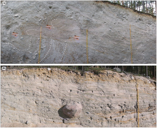
Figure 3. A. Proximal slope of a Niemisel moraine ridge at the Gunnarsbyn site (Lindén et al. Citation2008), displaying the typical architecture of the “proximal ridge element” sediment facies association; the primary sediments overprinted post-depositional glaciotectonic deformation. The lower part of the section shows interbedded silt, fine sand and gravelly sand, all folded into an isoclinal fold and cut by a major thrust plane, above which is a sequence of folded and stacked thrust sets of gravelly sand. A few bedding surfaces are enhanced by hatched white lines and thrust surfaces with red arrows. The section is perpendicular to the ridge crest, and the ice stress direction during deformation was from the NW. B. Distal part of a Niemisel moraine ridge at the site Rörån 1 (Lindén et al. Citation2008) displaying some typical “distal ridge element” sediment facies associations (DRF), sediment deposited within a lee-side cavity to the proto-ridge formed from folding and thrusting of the “proximal ridge element” sediments. The section, which is perpendicular to the ridge crest line, shows interbedded units of fine sand and silt (dominant) but also gravel beds and occasional silty diamicts, all beds with considerable lateral continuity. At the top is a massive diamict, forming the “draping element” of the ridge architecture (DF). The depositional direction was from left to right. Note the large drop boulder in the centre of the section, deposited from the cavity roof. Measuring sticks are 4-m tall.
The key aspect in the formation of Niemisel ribbed moraines, as depicted in Figure , is their initiation at the ice–bed interface, that is, the formation of the proto-ridges. The sediment architecture suggests deep-reaching brittle thrusting and/or ductile folding of pre-ridge sediments; such bed failure occurs when the total glaciotectonic stress (e.g., Aber et al. Citation1989) exceeds the shear strength of the substrate, the latter being highly dependent on the basal water pressure. It is argued [see detailed discussion in Lindén et al. (Citation2008)] that the basal water pressure at a regional scale fluctuated depending on seasonal variations in meltwater recharge to the subglacial system and substratum. This caused marked seasonal differences in bed strength and, as a result, spatial and temporal changes in bed rheology. During the peak meltwater season with high porewater pressure and thus very low effective stress, bed sediment shear strength (low-strength bed rheology end-member) was determined only by sediment cohesion, enabling the formation of a deforming mobile layer (cf. Boulton Citation1987; Boulton & Hindmarsh Citation1987) all the way to the subaqueous ice margin. As an opposite bed rheology end member (high-strength bed rheology) was when a minimum of meltwater was introduced to the bed, causing it to be stiff (not deforming) all the way to the ice margin. Seasonal shifts between these two bed rheology phases produced increased compression in the distal direction of the deforming bed zone and eventually localised folding and/or thrusting in a transitional zone to rigid bed conditions. It is suggested that the initial phase of ribbed moraine formation, as manifested by fold and/or thrust structures in the ridge-proximal parts (T1A/T1b in Fig. ), occurred at “favourable” positions during this up-flow propagation of the deforming-bed/rigid-bed transition, possibly beneath a thin, still deforming-bed zone. According to this scenario, the proximal ribbed moraine-forming process is thus tied to the slow or no-melt season as opposed to the De Geer-moraine formation during melt-peak season at the ice margin.
Ribbed moraine in the Indor area, province of Dalarna
From a Fennoscandian perspective, there was an early historical tendency to classify all transverse to ice-flow moraine ridges as Rogen moraine before the concept of ribbed moraine was introduced; this was heavily criticised by Lundqvist (Citation1969, Citation1981, Citation1989), who argued that the term “Rogen moraine” is a strict morphological term that should be reserved for a form group consisting of anastomosing moraine ridge nets to grouped but free-lying ridges, all with a more or less dominant crescentic planform with the concave ridge slope and ridge “horns” pointing in the direction of former ice-flow. Rogen moraine should also be associated with fluted or drumlinised elements that, in places, show transitions to ice-flow parallel forms (drumlins). In a Swedish regional context, ribbed moraine of the classic Rogen-shape type, that is, with more or less well-pronounced down-ice-pointing “horns”, starts at approximately 60˚ north and occurs frequently from this latitude, northwards, in valleys of the low-altitude mountains towards Norway and in the low-lying pre-montane terrain east thereof (Lundqvist Citation1989; Hättestrand Citation1997a, Citation1997b). Most studies on the internal composition of what has been described as Rogen moraine are from small exposures at various lateral, proximal or distal positions within the ridges. These studies report highly varying internal composition; coarse to fine-grained diamicts (massive, stratified, more or less rich in sorted sediment beds/lenses) with various genetic interpretations such as basal (active ice) till, melt-out till or flow till or to a large degree composed of meltwater sediment of various grain sizes (Lundqvist Citation1989, Citation1997). However, few studies describe the internal composition and architecture of Rogen ridges from proximal to distal slopes. An exception to this is the study by Shaw (Citation1979) on a cross-ridge section in the province of Jämtland, interpreted as in situ melt-out from stagnant ice with debris-rich zones oriented transverse to the ice flow in a preceding active-ice phase.
Möller (Citation2006) chose an area with extremely well developed ribbed moraine of the classic Rogen shape in the Indor valley (Fig. ) for a study of their internal composition and architecture. The Indor valley is just one of a number of valleys in the area trending NW–SE and leading towards the large Siljan impact structure. Most valleys here host Rogen-shaped ribbed moraine, while higher bedrock areas in between (rising to 400–500 m a.s.l.) host streamlined terrain with drumlin axes trending towards the SSE, which was in the regional ice-flow direction during the latest deglaciation. The ribbed moraine ridges on the Indor valley floor (~225–330 m a.s.l., which is well above the highest shoreline formed by the Ancylus Lake at ~210 m a.s.l.), have P10–P90 lengths and widths that range from 222 to 680 and 91 to 281 m, respectively. The P10–P90 heights range between 5.7 and 16.2 m, although higher ridges do occur (Table ). The distal side is usually steeper than the proximal side. The distances between adjacent ridge crest-lines vary between 150 and 400 m, with a mean of ~250 m. Crescent-shaped forms are most prominent in the wider valley segments, and the most conspicuous ridges are situated in Lake Indsjön, where a set of ridges forms boomerang-shaped islands and peninsulas (Fig. ). In narrower valley segments or along the lateral slopes of the wider valleys, the ridges are less crescentic and usually only the ridge end pointing towards the centre of the valley curves down-valley, while the other end disappears indistinctly into the valley slope. What was not seen on aerial photographs from the Möller (Citation2006) study, but is now revealed in the DSM (Fig. ), is very pronounced streamlined overprints at the widening of the valley towards the SE, eventually leading to near-drumlinised forms that are drawn out in the ice-flow direction.
Figure 4. The highly crescentic shaped Rogen-type ribbed moraine in the Indor Valley (Fig. ) with horns pointing in the ice-flow direction (right), which is towards the SE.
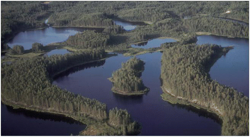
Figure 5. Hill shaded DSM of ribbed moraine in the Indor valley, province of Dalarna. Note the very pronounced horns in the centre of the valley – that is, “classic” Rogen moraine planform – and the surface, clearly streamlined from the NW, over the moraines in the south central part of the DSM (marked by arrows in the ice-flow direction), eventually leading to ice-flow parallel forms. The red arrow marks the three ribbed moraines in Lake Indsjön, as depicted in Figure . Red lines marked (a) and (b) show the locations of cross-moraine trenches in mid-ridge (a) and horn (b) positions. Colour coding in the DSM is from ~400 (reddish) to 250 (greyish) m a.s.l. The red dot in upper right corner of the inset map shows the location of the Indor area in a regional context. The inset frame in the upper left corner shows the most similar-looking planform in the Dunlop & Clark (Citation2006) classification of ribbed moraine, which is “downstream-curving ribbed moraine ridges” [redrawn from Figure 17 in Dunlop & Clark (Citation2006)]. LiDAR data provided by Lantmäteriverket, Sweden; ©Lantmäteriverket i212/927.
![Figure 5. Hill shaded DSM of ribbed moraine in the Indor valley, province of Dalarna. Note the very pronounced horns in the centre of the valley – that is, “classic” Rogen moraine planform – and the surface, clearly streamlined from the NW, over the moraines in the south central part of the DSM (marked by arrows in the ice-flow direction), eventually leading to ice-flow parallel forms. The red arrow marks the three ribbed moraines in Lake Indsjön, as depicted in Figure 4. Red lines marked (a) and (b) show the locations of cross-moraine trenches in mid-ridge (a) and horn (b) positions. Colour coding in the DSM is from ~400 (reddish) to 250 (greyish) m a.s.l. The red dot in upper right corner of the inset map shows the location of the Indor area in a regional context. The inset frame in the upper left corner shows the most similar-looking planform in the Dunlop & Clark (Citation2006) classification of ribbed moraine, which is “downstream-curving ribbed moraine ridges” [redrawn from Figure 17 in Dunlop & Clark (Citation2006)]. LiDAR data provided by Lantmäteriverket, Sweden; ©Lantmäteriverket i212/927.](/cms/asset/60f0eabe-0c79-43e8-a77f-2f3df969daec/sgff_a_1441903_f0005_oc.gif)
Möller (Citation2006) trenched Rogen moraine ridges in the Indor area in both mid-ridge and horn positions. The mid-ridge section revealed stacked successions of coarse diamicts interbedded with fluvial sediments of various facies states (Fig. ). Diamict beds, most commonly 0.5–1-m thick, were gravelly–sandy, matrix-supported, massive and usually non-graded, although beds with both normal and inverse clast grading did occur. Interbedded with the diamicts were subhorizontal, up to 4-m-long and 0.5–10-cm-thick beds of massive and planar parallel-laminated sand, massive sandy silt and thin clast-supported cobble gravel lags. Sand beds were often seen to connect to scours into underlying diamict with thicker sediment infill or laterally grading into gravel lags. Clast fabric measurements performed within six diamict beds (Fig. ) show dispersed, girdle, to weakly clustered fabric shapes with low to moderate distribution strengths (S1 eigenvalues = 0.51–0.62) with highly varying V1-axis orientations.
Figure 6. Example of vertical sediment succession in the central part of a side-to-side cross section over a Rogen-shaped moraine ridge in the middle ridge position [section marked (a) in Fig. ], representative of the whole section except for the distal slope. In the distal slope, the bedding instead of being in a subhorizontal position, the same types of sediments start to be inclined in the slope direction and individual beds show anticlinal/synclinal bending with dips of up to 70°. The subhorizontal bedding of the main part of the section continues towards the proximal slope of the ridge and is cut here at a considerable angle by the sloping ridge surface. Lithofacies codes are according to Table . Clast fabric data are plotted on Schmidt equal-area, lower hemisphere projections of clast long-axis orientation and contoured according to the Kamb method at 2σ intervals. The calculated strongest eigenvector azimuth (V1) and its eigenvalue (S1) for each data-set are according to Mark (Citation1973). Redrawn from part of Figure 5 in Möller (Citation2006).
![Figure 6. Example of vertical sediment succession in the central part of a side-to-side cross section over a Rogen-shaped moraine ridge in the middle ridge position [section marked (a) in Fig. 5], representative of the whole section except for the distal slope. In the distal slope, the bedding instead of being in a subhorizontal position, the same types of sediments start to be inclined in the slope direction and individual beds show anticlinal/synclinal bending with dips of up to 70°. The subhorizontal bedding of the main part of the section continues towards the proximal slope of the ridge and is cut here at a considerable angle by the sloping ridge surface. Lithofacies codes are according to Table 1. Clast fabric data are plotted on Schmidt equal-area, lower hemisphere projections of clast long-axis orientation and contoured according to the Kamb method at 2σ intervals. The calculated strongest eigenvector azimuth (V1) and its eigenvalue (S1) for each data-set are according to Mark (Citation1973). Redrawn from part of Figure 5 in Möller (Citation2006).](/cms/asset/2c5b5693-2ed3-459f-bc7b-40244495db51/sgff_a_1441903_f0006_oc.gif)
The section over a Rogen ridge horn [see Figure 9 in Möller (Citation2006)] reveals an intricate tectonic architecture due to the intercalation between three diamicts of distinctly different lithologies: a reddish porphyry-dominated diamict, an olive-green diabase-dominated diamict, and a dark grey rhyolite-dominated diamict (the section marked (b) in Fig. ), all of them matrix-supported and dominantly massive, although at places interbedded with thin sand beds, where they could be classified as weakly stratified diamicts. Below the morphological base of the ridge is a vaguely stratified gravelly–sandy diamict with unimodal, clustered fabric shapes (S1 eigenvalues = 0.77 and 0.82, respectively, for two clast fabric measurements performed) with their V1-axis orientations perpendicular to the general crest-line trend. Above this non-tectonised diamict, there is tectonic intermixing of beds of the diamict lithologies; reddish diamict occurs as “augens” in the olive-green diamict and vice versa and as “augens” in the dark grey diamict. Beds of olive green diamict display low-angle folds in the dominating reddish diamict; these fold structures and the aforementioned “augen” structures suggest ductile three-dimensional sheath folding of pre-existing sediments, which were more or less horizontally bedded in their original state. A number of thrust faults cut the ductile-deformation structures, displaying overturning of sediment structures into drag folds at their base, suggesting a late tectonic-phase change into dominantly brittle deformation. Measurements on shear planes, fold limbs and overturned fold stratification indicate a stress direction (S1 = 0.935) under deformation that was perpendicular to the main trend of the ridge but oblique to the crest-line of the horn.
Based on the sediment composition and architecture within these cross sections, Möller (Citation2006) proposed a two-step formation of the observed Rogen-shaped ridges. The sediment successions found in the mid-ridge position were interpreted as a stacked succession of sediment gravity-flow deposits interbedded with fluvial sediment. The depositional framework for these was a stagnant ice-cored moraine landscape arranged transversely to the former ice flow within an ice-marginal zone, the transverse zonation of debris-rich ice due to the ice activity and stress direction just before stagnation (controlled topography; Gravenor & Kupsch Citation1959). Due to back- and down-wasting of ice cores, inter-ridge troughs were filled with debris flow and fluvial deposits, which after landscape inversion were transformed into areas of transverse and hummocky moraines. Möller (Citation2006) proposed that this primary landscape formation occurred during one of a number of possible deglaciation phases of Fennoscandian ice sheets during the pre-Late Weichselian, a landscape of precursor “Rogen ribbed moraine ridges to be”. These ridges were preserved beneath cold-based ice during most part of the Late Weichselian glaciation (Kleman Citation1990; Kleman et al. Citation1997). At a very late stage of the last glaciation, when the previous cold-based ice–bed interface became wet-based (during deglaciation in the Preboreal; Stroeven et al. Citation2016), the precursor landforms were remoulded into the Rogen shape. The key features in this are the intense deformation at precursor ridge-ends into more or less distinct down-ice-flow-directed horns, and eventually – as suggested from the central lower part of the DSM in Figure – into ice-flow-parallel drumlins. This remoulding is demonstrated in a sequential formation model in Figure . Since the publication of Möller (Citation2006), growing evidence suggests that this part of Scandinavia was also deglaciated in the Middle Weichselian (the early part of MIS 3) after a MIS 4 glaciation (e.g., Hättestrand Citation2008; Mangerud et al. Citation2011; Möller et al. Citation2013; Hughes et al. Citation2015), a deglaciation equally probable for the formation of the Rogen moraine precursor ridges.
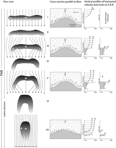
Figure 7. Reshaping of precursor ridges into Rogen-shape ribbed moraine, which varies from very little (slight bending of just one ridge end for ridges in a valley-lateral position) to “boomerang” reshaping, often on ridges in a more central valley position, to total reshaping of pre-existing bed morphology into streamlined terrain (drumlins). The sequential model depicts seven steps (I–VII) with gradual reshaping with time of the pre-existing planform to the right (the line arrows depict flow-line adjustment to the bedform). In the middle are the time-arbitrarily chosen vertical, parallel to ice-flow cross profiles, (A) over the central part of the precursor ridge and (B) over the end-part of the precursor ridge, with the principal vertical velocity distribution in the sediment (deforming sediment; grey shaded) to ice–bed interface sliding to internal ice deformation (white, non-shaded) on the left in the right column and the deforming sediment strain rate on the right in the right-hand column for profiles (A) and (B), respectively (grey shaded). Pre-deformation stage, I. – The precursor ridge is beneath a frozen ice–bed interface. Sediments are in a frozen state, with no basal ice sliding and sub-bed deformation. Deformation stages II–III. – As the ice margin approaches during the LGM deglaciation of the area, the ice–bed interface changes to a wet-based one; sediment starts to deform mainly at the end parts of the precursor ridge with ductile deformation at high strain rates and deflection of sediment in the down-ice direction, while there is very limited deformation of sediment along a flow line at the mid-ridge position. Deformation stages IV–V. – Deformation continues with time, preferentially located at the precursor ridge end-point at enhanced ice anddeforming bed velocity and strain compared with that over mid-ridge parts, with the crescentic planform enhanced over time. Remoulding stops with deglaciation, that is, leaving more or less remoulded forms in front of the receding ice margin. Deformation stages VI–VII. – If remoulding is not interrupted by deglaciation, it continues with, as a final result, total reorganisation of the pre-existing bed into ice-parallel streamlined landforms (drumlins) as seen in the lower right corner of the DSM in Figure . Reprint of Figure 14 in Möller (Citation2006).
Ribbed moraine in the Åsnen area, province of Småland
The terrain above the highest shoreline of southern Sweden (~65 m a.s.l. within the province of Blekinge) is characterised by a 20–40-km wide, east–west trending zone of hummocky moraine integrated with areas of ribbed moraine across the south Småland peneplain, which westwards seems to continue into the N–S trending, mainly subaqueously formed Gothenburg moraine (Möller Citation2010; Möller & Dowling Citation2015). The latter consists of glaciofluvial ice-contact deposits in valleys, linked together by moraine ridges over higher areas in between; the Gothenburg moraine formed during a major ice advance during the general ice margin retreat in the last deglaciation of the area (Wenner Citation1951; Wedel Citation1971; Hillefors Citation1975, Citation1979; Berglund, Citation1979). One of the most pronounced ribbed moraine areas within the hummocky moraine zone is situated SW of Lake Åsnen (Fig. ); in an area of ~30 km2 there are some 485 individual moraine ridges arranged in smaller subgroups trending W–E, WSW–ENE and WNW–ESE, which is roughly perpendicular to the ~N–S ice-flow direction at deglaciation in this central part of Småland. The ridges come in a wide range of shapes with the planform pattern best concurring with the form group “anastomosing ribbed moraine ridges” according to the form classification by Dunlop & Clark (Citation2006). There are large differences in size between individual ridges: P10–P90 lengths and widths are in the ranges of 142–553 and 52–157 m, respectively, and the P10–P90 height ranges between 5.0 and 14.5 m (Table ). The distances between adjacent ridge crest-lines vary between 80 and 275 m, with a mean distance of ~170 m.
Figure 8. Hill shaded DSM of ribbed moraine in the lake Åsnen area, County of Småland. Colour coding is from ~200 (reddish) to 140 (grey-bluish) m a.s.l. The red dot in the lower right corner of the inset map shows the location of the area in a regional context. The inset frame in the upper left corner shows the most similar-looking planform in the Dunlop and Clark (Citation2006) classification of ribbed moraine, which is “anastomosing ribbed moraine ridges” [redrawn from Figure 17 in Dunlop & Clark (Citation2006)]. LiDAR data provided by Lantmäteriverket, Sweden; ©Lantmäteriverket i212/927.
![Figure 8. Hill shaded DSM of ribbed moraine in the lake Åsnen area, County of Småland. Colour coding is from ~200 (reddish) to 140 (grey-bluish) m a.s.l. The red dot in the lower right corner of the inset map shows the location of the area in a regional context. The inset frame in the upper left corner shows the most similar-looking planform in the Dunlop and Clark (Citation2006) classification of ribbed moraine, which is “anastomosing ribbed moraine ridges” [redrawn from Figure 17 in Dunlop & Clark (Citation2006)]. LiDAR data provided by Lantmäteriverket, Sweden; ©Lantmäteriverket i212/927.](/cms/asset/5e2c3015-c163-45a7-aac2-fec0230fc48c/sgff_a_1441903_f0008_oc.gif)
Ribbed moraine ridges in this area were trenched in three locations, from which the internal sediment composition and architecture, as revealed in these sections, are extensively described in Möller (Citation2010). Below is a brief summary for one of the sites (Horgeboda) on its vertical succession of discerned sedimentary units A–C and their lithofacies associations, shown in an idealised log (Fig. ) together with 6 of 12 of the clast fabric analyses performed.
Figure 9. Synthesised log of sedimentary units A–C and sediment facies in the Horgeboda ribbed moraine section. Lithofacies codes are according to Table . Clast fabric data are plotted on Schmidt equal-area, lower hemisphere projections of clast long-axis orientation and contoured according to the Kamb method at 2σ intervals. The calculated strongest eigenvector azimuth (V1) and its eigenvalue (S1) for each data-set are according to Mark (Citation1973). Reproduced from Möller & Dowling (Citation2015).
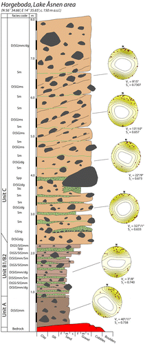
Unit A is a matrix-supported, massive silty–sandy diamict with dispersed clasts above a non-abraded bedrock surface. Clast fabric analyses show unimodal, clustered fabric shapes with strong preferred clast axis orientations (S1 = 0.69–0.76; n = 3) and with the V1-axis orientations approximately perpendicular to the general trend of the ridge crest. This continues with a gradational contact into units B1–B2, characterised in their lower part (B1) by matrix-supported, massive silty–sandy diamict, repeatedly interbedded by thin beds of massive and planar parallel-laminated gravelly sand and coarse to fine sand, giving the subunit a stratified appearance. Subunit B2 is somewhat coarser, with indistinct beds and lenses of matrix-supported and massive gravelly–sandy diamict, alternating with thinner beds of massive silty–sandy diamict and beds of massive and planar parallel-laminated sand. Clast fabric analyses show clustered fabric shapes and strong to moderate preferred clast axis orientations (S1 = 0.67 and 0.76; n = 2) with V1-axis orientations approximately perpendicular to the general trend of the ridge crest.
Unit C forms the main bulk of the section continuing to the ground surface; it is predominantly a matrix-supported sandy–gravelly diamict with a generally dispersed large-clast distribution. However, in the central part, there is an “en echelon” clustering of small boulders and cobbles into bands with a 20–25° dip towards the proximal slope of the ridge. Boulders further enhance this pattern with clearly defined long axes, showing the same imbrication. The diamict is sometimes massive in appearance, but in detail it often shows a lateral and vertical disorganised grading between lenses of a sandier or more gravelly diamict or alternating lenses with higher or lower degrees of sorting. In the upper central part of the section, the diamict also reveals a vague stratification, dipping 20–25° to the north. This stratification is made up of horizons with a higher content of pebble and gravel clasts and other textural differences, enduring laterally for some length and coinciding with the “en echelon” boulder clustering and imbrication. Clast fabric analyses show that all but one of the fabric shapes are clustered and reveal moderate to strong preferred clast axis orientations (S1 = 0.61–0.73; n = 6), whereas one fabric measurement reveals a dispersed orientation of clast axes in the preferred V1/V2 plane (S1 = 0.52). The calculated mean V1 axis orientation/plunge for all sets is 6°/6°, that is, a consistent dip towards the proximal slope of the ridge and perpendicular to the trend of its crest-line. Unit C is also characterised by the frequent occurrence of sorted sediment intrabeds, predominantly massive but occasionally planar parallel-laminated silt and sand. The contacts with the enclosing diamict are usually indistinct. Bending and deformations of otherwise horizontal beds can be observed in connection with boulders; anticlinal draping on top of larger boulders and synclinal bending below boulders, conformable with their basal configuration. An important observation is that the vaguely stratified diamict in the upper part of the unit is cut by thin, horizontal to subhorizontal sand intrabeds, the cross-cutting relation showing the latter to be younger in their formation. Another important feature is sorted sediment, localised only below the basal contact of larger boulders without any continuation outside the vertical projection of the boulder in question, or as thicker sediment accumulation below the boulder, continuing as much thinner sediment beds outside the vertical projection of the boulder.
Möller (Citation2010) stressed that single sedimentological criteria that exclusively point in one direction for genetic interpretation of documented diamicts and associated sorted sediment sequences – that is, diagnostic criteria – are often not at hand, but taken together the sediment sequence shown in Figure , which is also representative for the other ridge trenches, suggests that internal sediments of ribbed moraine in the Åsnen area represent successions of melt-out till interbedded with syndepositionally deposited sorted sediment beds. The vertical and lateral facies changes were interpreted to be the result of an accelerated process of melt-out from debris-rich ice with an increasing influence and activity of meltwater. Units A and C are considered to be end members in such a sequence with unit B as an intermediate unit, having properties of both end members. Unit A thus indicates a slow melt-out release with lack of meltwater activity at this stage, whereas the alternating beds of silty–sandy and gravelly–sandy diamict in unit B mark an increased winnowing of fines at the melting ice–bed interface, which reached its peak during the deposition of unit C diamict with the formation of coarse, disorganised graded diamict and associated sorted sediment intrabeds. Sediment pockets below boulders and draped beds above boulders are regarded as diagnostic for a melt-out till interpretation (e.g., Shaw Citation1982, Citation1983b; Munro-Stasiuk, Citation2000).
Based on the genetic interpretation of ribbed moraine in the Åsnen area and, in a regional context, the existence of the wide zone of hummocky moraine intercalated with ribbed moraine with predominantly streamlined terrain north thereof, Möller (Citation2010) was led to conclude that there were major spatial and temporal differences in glacial dynamics and thermal regimes during the formation of these landscapes. A conceptual model for such spatial and temporal changes in basal dynamics and thermal regimes is shown in Figure with its panels A–E drawn as profiles starting from the Baltic basin in the south (Baltic Ice Lake) and northwards, over the ribbed/hummocky moraine area and into the streamlined terrain to be [model concept in Fig. building on Möller (Citation1987) and Björck & Möller (Citation1987)]. This model essentially suggests that ribbed moraine started to form in an active ice phase due to debris entrainment at the ice–bed interface with adfreezing of water and sediment (panels B–C, Fig. ). This adfreezing caused density zonation of basally incorporated debris, which followed by incremental stagnation of debris-charged ice under frozen-bed conditions. This lead to a wide zone of such stagnant ice, the debris-charged zones forming ribbed moraine “embryos” (panel C, Fig. ). These formed incrementally during recession of the freezing-on zone at the same time as a frontal frozen-bed zone grew wider (panel D, Fig. ). During the final melting of the stagnant-ice zone, an in situ melt-out of the ribbed moraine “embryos” occurred. The survival of these as melt-out till ridges was highly dependent on the release and possible redistribution of glacial debris (panel E, Fig. ).
Figure 10. A conceptual model of ice dynamic and palaeoenvironmental change, with emphasis on spatial and temporal changes at the ice–bed interface as an explanatory tool for landscape evolution for the broad E–W-trending zone of hummocky and ribbed moraine across south Småland and the streamlined terrain north thereof. For an in-depth discussion of the processes, see Möller (Citation2010) and Möller & Dowling (Citation2015). Panel explanation: Panel A. – Wet-bedded conditions during deglaciation all the way to the ice margin (process zone A; PZ-A), the latter situated in a subaqueous position with ablation as calving into the Baltic Ice Lake in the south. Panel B. – The hummocky and ribbed moraine area, starting just above the highest shoreline, suggests a major and regional shift in the basal thermal regime from wet-based to freezing-on conditions (process zone B; PZ-B) in a frontal zone of the ice sheet, a prerequisite for basal entrainment of glacial debris that is arranged in debris-charged zones transverse to the ice-flow and stress direction due to differential folding and thrusting and incremental stagnation. Panel C. – The marginal zone gradually turned into a frozen-bed zone with the ice–bed interface below the pressure melting point and no basal sliding (process zone C; PZ-C). In this stage, PZ-B formed an intermediate zone to PZ-A, propagating backwards, that is, in the proximal direction to the ice flow, building a polythermal ice margin. The distal boundary of PZ-B coincides with what we define as the “activity limit” (Lagerlund et al. Citation1983), which is the most distal boundary of basal activity along the ice–bed interface at a given time. Localised compressive flow within PZ-B is suggested to have led to enhanced folding and thrusting of debris-rich ice and zonal thickening (density zonation), more or less transverse to the stress directions, eventually leading to the formation of ribbed moraine “embryos”. These could later, after incremental stagnation, melt out in situ, forming “Åsnen-type” ribbed moraine (Möller, Citation2010) (see below). Panel D. – With continued recession of PZ-B, the ice surface was lowered due to surface ablation until debris-rich ice was encountered; as debris melted out, a protective cover [supraglacial ablation complex; e.g., Shaw (Citation1979)] formed, causing a drastic slowdown of further melting. The combination of lowering of the ice surface and recession of the PZ-A/PZ-B boundaries led to a successively larger area of stagnant, debris-charged ice with ice below the pressure-melting point (PZ-C) in front of the receding activity limit. Panel E. – During the final melting of the stagnant-ice zone was an in situ melt-out of the ribbed moraine “embryos”. Their survival as melt-out till ridges was highly dependent on the release and redistribution styles (or the absence of the latter) of sediment from the stagnant ice. Reprint of Figure 20 in Möller & Dowling (Citation2015).
![Figure 10. A conceptual model of ice dynamic and palaeoenvironmental change, with emphasis on spatial and temporal changes at the ice–bed interface as an explanatory tool for landscape evolution for the broad E–W-trending zone of hummocky and ribbed moraine across south Småland and the streamlined terrain north thereof. For an in-depth discussion of the processes, see Möller (Citation2010) and Möller & Dowling (Citation2015). Panel explanation: Panel A. – Wet-bedded conditions during deglaciation all the way to the ice margin (process zone A; PZ-A), the latter situated in a subaqueous position with ablation as calving into the Baltic Ice Lake in the south. Panel B. – The hummocky and ribbed moraine area, starting just above the highest shoreline, suggests a major and regional shift in the basal thermal regime from wet-based to freezing-on conditions (process zone B; PZ-B) in a frontal zone of the ice sheet, a prerequisite for basal entrainment of glacial debris that is arranged in debris-charged zones transverse to the ice-flow and stress direction due to differential folding and thrusting and incremental stagnation. Panel C. – The marginal zone gradually turned into a frozen-bed zone with the ice–bed interface below the pressure melting point and no basal sliding (process zone C; PZ-C). In this stage, PZ-B formed an intermediate zone to PZ-A, propagating backwards, that is, in the proximal direction to the ice flow, building a polythermal ice margin. The distal boundary of PZ-B coincides with what we define as the “activity limit” (Lagerlund et al. Citation1983), which is the most distal boundary of basal activity along the ice–bed interface at a given time. Localised compressive flow within PZ-B is suggested to have led to enhanced folding and thrusting of debris-rich ice and zonal thickening (density zonation), more or less transverse to the stress directions, eventually leading to the formation of ribbed moraine “embryos”. These could later, after incremental stagnation, melt out in situ, forming “Åsnen-type” ribbed moraine (Möller, Citation2010) (see below). Panel D. – With continued recession of PZ-B, the ice surface was lowered due to surface ablation until debris-rich ice was encountered; as debris melted out, a protective cover [supraglacial ablation complex; e.g., Shaw (Citation1979)] formed, causing a drastic slowdown of further melting. The combination of lowering of the ice surface and recession of the PZ-A/PZ-B boundaries led to a successively larger area of stagnant, debris-charged ice with ice below the pressure-melting point (PZ-C) in front of the receding activity limit. Panel E. – During the final melting of the stagnant-ice zone was an in situ melt-out of the ribbed moraine “embryos”. Their survival as melt-out till ridges was highly dependent on the release and redistribution styles (or the absence of the latter) of sediment from the stagnant ice. Reprint of Figure 20 in Möller & Dowling (Citation2015).](/cms/asset/91b346a3-54af-4fcb-9866-7d260e016cb9/sgff_a_1441903_f0010_oc.gif)
Morphology of ribbed moraine in the Niemisel, Indor and Åsnen areas
The three case study areas of ribbed moraine described above were subject to morphometric analyses, whose results are shown in Figure . The Åsnen area contains 485 mapped features, Indor contains 145 mapped features and Niemisel contains 656 mapped features (Table ). These populations are not as large as those now commonly seen in the literature on streamlined terrain (e.g., Spagnolo et al. Citation2010; Clark et al. Citation2009) and in some works on ribbed moraine (e.g., Dunlop & Clark Citation2006). However, the sample size is large enough to allow statistically significant comparisons between them, particularly given that a population of around 200 is generally considered sufficient for geomorphological distribution modelling (Hjort & Marimion Citation2008).
Figure 11. Results of the morphometric analyses carried out on the three ribbed moraine locations. Åsnen is in red (+), Indor in blue (x) and Niemisel in black (*). All values were rounded to two decimal places before the analyses were carried out. A. Histogram of ribbed moraine length (m) with frequency normalised to 1. B. Histogram of ribbed moraine width (m) with frequency normalised to 1. C. Histogram of ribbed moraine height (m) with frequency normalised to 1. D. A plot of ribbed moraine length versus width with all values log-normalised. E. A plot of ribbed moraine width versus height with all values log-normalised. F. A plot of length versus width versus height with all values log-normalised.
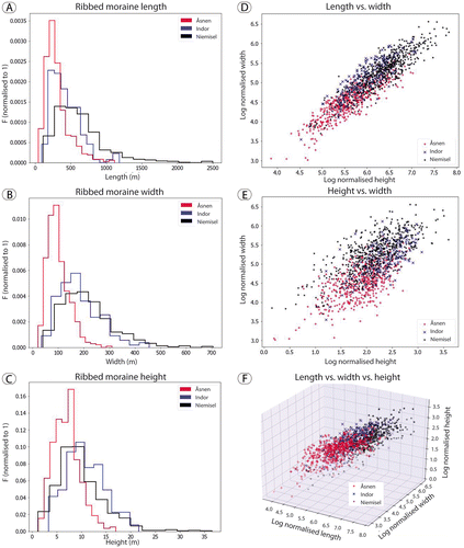
Panels A, B and C of Figure describe the distribution of the three measured metrics (length, width and height) with the frequency normalised to 1. The frequency is normalised to 1 in order to allow a direct comparison of the shape of the distributions on the same axes. For the height and width metrics, the Indor and Niemisel populations have essentially the same distribution shape. In contrast to this, the Åsnen distribution has a shorter right-hand tail and the centre (median) of the distribution is located to the left of the centre of the Indor and Niemisel distributions. However, this is not the case with regard to the length metrics; here the Indor distribution sits between the Åsnen and Niemisel distributions in terms of both the overall shape of the distribution and the relative size of the features contained within it. The Åsnen and Indor right-hand tails terminate in essentially the same place, whereas the Niemisel right-hand tail extends considerably further. The long tail of the Niemisel distribution is indicative of the larger features that are found in this locale.
Panels D, E and F of Figure compare the relationships between the three measured metrics in each population. In panel D we can see that, as expected (Clark et al. Citation2009), there is a strong relationship between the length and width of a feature. The Indor and Niemisel populations plot in essentially the same two-dimensional space, although the Niemisel population tends to be located towards the larger end of the scale, whereas the bulk of the Åsnen population is located lower down the graph. However, this is all whilst remaining part of the same overall relationship between the two metrics; that is, the relationship between length and width is the same as in the other two areas but the features are in general smaller. In panel E, the relationship between height and width is not as strong as that found between length and width. Nonetheless, the same pattern is seen whereby those features from the Åsnen area are in general smaller but connected to the size populations of the Indor and Niemisel areas. Finally, panel F plots all three metrics against one another and once again finds a similar pattern. Åsnen features plot in a cluster that is a little separated from the other two areas and Niemisel features have a tendency to be larger than the other two whilst remaining within the upper bounds of the size of the features seen elsewhere. In general, it can be said the three locales are part of the same continuum of shape but form sub-populations within this continuum.
Drumlin (streamlined terrain) cases
The literature on drumlins (streamlined terrain) is immense, as documented in Menzies (Citation1979) and more recently by Stokes et al. (Citation2011). From the literature, is it evident that there is a large degree of geomorphological variation within what are accepted as drumlin forms. There is also considerable variety in their sedimentary compositions and internal structures, both within coherent drumlin swarms and between different geographical areas of glaciated terrain. Irrespective of this, recent morphometric studies suggest that these streamlined features (including MSGLs) are, as discussed in the introduction, located on a continuum of morphological expression (e.g., Spagnolo et al. Citation2014; Dowling et al. Citation2015; Ely et al. Citation2016). The key question is then whether the large variation in their form and composition suggests that drumlins should be regarded as polygenetic, that is, that a number of different mechanisms and processes along the ice–bed interface eventually lead to more or less the same morphologic end product [site-specific drumlin formation following the notion of Stokes et al. (Citation2011)] or whether they, especially in the subglacial bedform context discussed in the introduction, “result from a single process that occurs across a large area and leads to the development of the drumlinised surface” [process-specific, as argued by Stokes et al. (Citation2011)].
We have recently published a number of papers dealing with drumlin morphology, internal composition and possible origin in a regional context for southern Sweden (Dowling Citation2016; Dowling et al. Citation2015, Citation2016; Möller & Murray Citation2015; Möller & Dowling Citation2015, Citation2016). We reference these papers for more in-depth descriptions and interpretations, and here review the main conclusions on the types of drumlins typical for the glacial landscape of south Sweden and how streamlined terrain relates – or not – to ribbed moraine. Based on internal composition and architecture, we identify three main types of drumlins or streamlined terrain within south Sweden: (i) rock-cored drumlins, (ii) soft-cored (till) drumlins and (iii) streamlined patches or more singularly occurring drumlins with cores of glaciolacustrine and/or glaciofluvial sediments.
Rock-cored drumlins
Within southern Swedish streamlined terrain, there is a dominance of rock-cored drumlins, which are one of the five principal types differentiated on the grounds of their internal organisation: the “part-bedrock/part-till” drumlin of Stokes et al. (Citation2011). In the past, many authors have referred to such drumlins as “crag and tail” features (e.g., Glückert Citation1973; Gillberg Citation1976). This term is however not appropriate because the position of the rock core (the crag) is found to vary greatly throughout the Swedish data-set (Möller Citation1987; Dowling et al. Citation2015) and there are often prominent pre-crag elements [see DSM examples in Dowling (Citation2016)]. Most often, however, the rock element is situated in a very proximal position of the drumlin. Clark (Citation2010) names this type of feature as an “obstacle drumlin” in recognition of the rock core.
Our statement on the large dominance of rock-cored drumlins in the glacial landscape of south Sweden stems from mapping of streamlined features on high-resolution hill-shaded DSMs, numbering ~10 000 features in Dowling et al. (Citation2015) and expanded to ~20 000 mapped features in Dowling (Citation2016). We found a clear connection for rock-cored drumlins occurring over crystalline shield areas, which are dominant in south Sweden north of the province of Skåne, while areas with basement consisting of sedimentary rocks, often also co-associated with thicker Quaternary drift sheets, host soft-cored drumlins (Möller & Dowling Citation2016). A detailed mapping of drumlins was carried out in three areas in the province of Småland in Möller & Dowling (Citation2015) (north of the E–W-trending zone of hummocky/ribbed moraine described above in connection to ribbed moraine in the Åsnen area). One of these areas centred on Lake Åsnen (Fig. ) revealed 100% rock-cored drumlins [187 features mapped; mean length, width and height of 333, 89 and 4.3 m, respectively, with a mean elongation ratio of 3.7 (Möller & Dowling Citation2015)]. Some of these, usually the largest, have multiple rock cores, while most have single rock cores; these show up as rough surfaces in the DSMs, usually in a very proximal position, through the otherwise smooth till surface. Our mapping over southern Sweden does not reveal any distal or proximal transitions from ribbed moraine tracts into rock-cored drumlin flow sets or from rock-cored drumlins into ribbed moraine tracts, linked in a common bedform system.
Figure 12. Hill shaded DSM of drumlins on Vemboö within Lake Åsnen; drumlins are all of the rock-cored type. Some of the protruding rock nobs are marked by white arrows. Colour coding is from ~190 (reddish) to 140 (blue greyish) m a.s.l. The red dot in the lower right corner of the inset map shows the location of the area in a regional context. LiDAR data provided by Lantmäteriverket, Sweden; ©Lantmäteriverket i212/927.
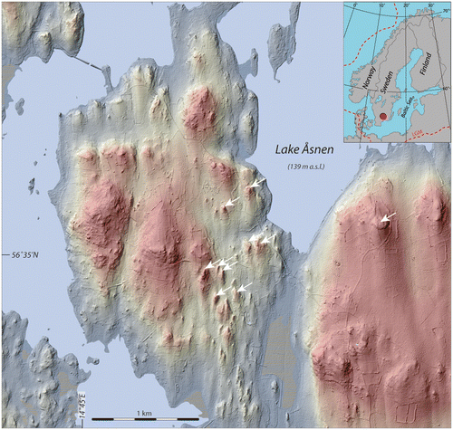
Most geologists would argue that the formation of rock-cored drumlins can be most easily explained compared to other drumlin types; it consists of deformation and plastering-on of sediments around a (rock) obstacle at the ice–bed interface combined with the filling of a downstream cavity formed in the pressure shadow generated by said obstacle (e.g., Boulton Citation1982; Hart Citation1997). However, despite being an accepted model for rock-cored drumlin formation, there are unfortunately few sedimentological studies from cross-drumlin trenches that support the model; this is a clear area for future research.
One of few such descriptions of lee-side cavity infill sequences is from nearby Blekinge (Nilsson Citation1996), ~50 km to the southeast of the Åsnen area. The coastal plain of Blekinge is characterised by exposed bedrock over higher areas, distinct lee-side tails from such bedrock heights (crag-and-tail features), and lower terrain draped or infilled with glaciolacustrine and beach sediments; the streamlined terrain here constitutes 100% rock-cored drumlins (Fig. ). Somewhat west of the area depicted in Figure is the Järnavik site described in the bachelor’s thesis of Nilsson (Citation1996), which merits description for a larger audience. In the distal direction (i.e., south) of an outcropping bedrock height there was a sediment exposure measuring 35 m in length and ~9 m in depth below the ground surface (Fig. ); Nilsson (Citation1996) divided exposed sediments into five stratigraphic/sedimentological units (A–E), whose descriptions and interpretations we briefly summarize below.
Figure 13. Hill shaded DSM of drumlins on the Gö peninsula, south-central Blekinge; drumlins are all of the rock-cored type. Colour coding is from ~30 (reddish) to 0 (Baltic Sea) m a.s.l. LiDAR data provided by Lantmäteriverket, Sweden; ©Lantmäteriverket i212/927.
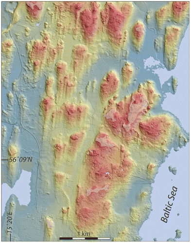
Figure 14. Sediment succession in the lee-side position (south) of a bedrock ridge at Järnavik in coastal Blekinge, an area with streamlined terrain with all drumlins being of the rock-cored type (Fig. ). Section redrawn from part of the originally 35-m long section described in Nilsson (Citation1996); the sediments are divided into five stratigraphic units (A–E). The ground surface is ~20 m a.s.l. Facies codes are according to Table .
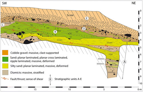
Unit A (+5 m thick; subdivided into subunits A1–A8) is a stacked sequence of interbedded silty–sandy diamict beds, which are either massive or stratified, and silty sand units, built by 10–100-cm-thick beds of fine sand grading into silt. The massive diamicts have moderately high clast fabric strengths (S1 = 0.665 and 0.622) with principal eigenvectors (V1) from 102°/21° and 82°/17°, respectively, which is a substantial offset from the regional ice flow direction from N 6° E as suggested by striae on bedrock outcrops in the proximal direction to the sediment section. Upper bed contacts of sorted sediment with massive diamicts are sharp and erosive, while lower bed contacts are non-erosive; internal lamination follows the configuration of those contacts conformably. Contacts with overlying stratified diamicts are non-erosive. Beds within unit A show synsedimentary deformation, as demonstrated by up-bending and folding of laminated sediments, and the beds are cut by reverse faults or bounded by thrust faults. Unit A tectonics, erosional surfaces and emplacement of massive diamicts (traction till; subunits A1 and A3) are interpreted as being due to basal processes at the ice–bed interface recoupling from ESE, while stratified diamicts and laminated sediments (subunits A2, A4, A5, A6, A7, A8) are interpreted as having formed subaquatically during repeated ice–bed decoupling with cavity formation, into which sediments were deposited from sediment gravity flows as diamictic turbidites and thin, normally graded fine sand to silt beds in a low-energy environment (no fluvial trough-flow).
Unit B (up to 2-m thick) was predominantly built by vertical accretion of laterally interfingering beds of planar parallel-laminated, planar cross-laminated, ripple laminated (type A trough cross-lamination) and massive medium to fine sand, with thin silt beds as minor facies constituents. Unit B beds are cut by a number of faults, the longer faults being of reverse thrust type and the shorter being normal faults. The facies assemblage of unit B suggests deposition at varying flow velocities from prograding bars, flat beds (upper flow regime) and ripple migration, all in a re-opened, water-filled cavity with fluvial trough-flow. As thrust surfaces through unit B reach contact boundaries with units C and D, it is suggested that emplacement of the latter is coupled to cavity closure upon which ice–bed recoupling initiated thrusts into the cavity sediments. Unit C is laterally overlying unit B with a sharp boundary (continuing outside the drawing in Fig. , growing to a thickness of 2.4 m), which is a stratified silty–fine-sandy diamict interpreted as having been produced from basal ice–bed shearing of sediment towards a water-filled cavity into which the sediments continued as sediment gravity flows stacking up on top of each other. Larger clasts randomly distributed in the sediments show down-bent lamina beneath them but on-lapping lamina on top; this suggests that they are drop clasts that were released from the cavity roof and embedded into inflowing sediment gravity-flow deposits. Unit D (~1.5-m thick) has an erosional lower contact with units A, B and C (from the NE towards the SW) and constitutes a vaguely stratified sandy–silty diamict continuing into a more massive one in the upper part of the unit, with frequent interbedding with thinner sand beds, usually massive and of undulating shape. The massive diamict shows unimodal clustered clast fabric shapes with moderate orientation strengths for the principal eigenvector (S1 = 0.692 and 0.661, respectively, for two fabric analyses). The unit D sediments are interpreted as a sequence of subglacially sheared material, eroded from unit B in the lower part and deposited after cavity infill (units B and C and subsequent cavity closure) as a stratified deformation till, with incorporated sorted sediment drawn out in the deformational stress direction, eventually continuing into the deposition of a massive diamict during more pervasive deformation (traction till; Benn & Evans Citation1996; Evans et al. Citation2006). The topmost unit E sediment is clast-supported cobbly–sandy gravel formed from wave-induced erosion (erosional contact with unit D) and deposited as the site rose above sea level during glacio-isostatic uplift and thus shoreline regression from its highest position at ~65 m a.s.l. during deglaciation (Björck & Möller Citation1987).
In summary, the sediment succession found in the bedrock ridge lee-side position at Järnavik is interpreted by Nilsson (Citation1996) to represent a series of repeated cavity openings and closures (>7) during which there was sediment infill of various facies states; for open cavities, this was connected to a subglacial linked cavity system followed by the deposition of both fluvially transported sediments and sediment gravity flows, with the latter shearing into the cavity along a deforming ice–bed boundary outside the cavity, and from there continued into the cavity as turbidites. During cavity closures (bed recoupling) there was thrusting and/or erosion of cavity deposits and the deposition of deforming bed sediments (stratified diamict) as well as traction till (massive diamict). Clast fabrics in massive diamict deviate from the regional ice flow direction (~N), suggesting stress transfer from a lateral direction (~E) towards and into the cavity [the herringbone pattern of ice flow into a drumlin down-flow from its initiation point, e.g. as suggested by Hooke & Medford (Citation2013)]. The recurrent opening and closing of the lee-side cavity are suggested to have been linked to the annual fluctuation in basal water pressure, mirroring the basal melt rate and influx from supraglacial melting.
Recently proposed competitive explanations for the formation of rock-cored drumlins are the “instability theory” (Stokes et al. Citation2013) and the “ELH” (Eyles et al. Citation2016), both theories or hypotheses in principle suggesting that a thick pre-existing drift sheet was gradually eroded downwards, leaving the most basal part of it as drift remnants anchored around or behind protecting bedrock knobs. We do not consider this approach to be applicable in a general Scandinavian context, considering that the Fennoscandian ice sheet in its central area was dominantly sitting on crystalline shield rocks. In southern Sweden there is – and most certainly was over repeated glaciation phases – a thin till cover [usually <5 m; see Figure 11 in Dowling (Citation2016)] and not those thick drift sheets that seem to be the starting point and prerequisite for the sediment evacuation processes implied by both the “instability theory” and the “ELH”. We argue that rock-cored drumlins are not part of a subglacial bedform continuum, even though the morphometrics plot as such. They should thus have the same status as rock drumlins, which Stokes et al. (Citation2013) regard as a site-specific genetic drumlin type of its own. This also holds for rock-cored drumlins; they should be regarded as a site-specific genetic type of their own, differentiated from the group of different types of soft-cored drumlins.
Soft-cored (till) drumlins
Möller & Dowling (Citation2016) describe N–S-trending streamlined terrain on the Närke plain, south-central Sweden (Fig. ), which rests on thick Quaternary strata (usually 10–20 m) on top of down-faulted Palaeozoic sedimentary rock, bounded to the west and south by fault zones to crystalline basement rocks. The drumlins on the Närke plain above the thick drift sheet – which we refer to as the Hackvad drumlins – are all decoupled from underlying bedrock and are all of the soft-cored type with P10–P90 lengths and widths in the ranges of 180–1135 and 40–212 m, respectively, and a P10–P90 height that ranges between 1.1 and 9.9 m. The mean elongation ratio is 5.4. Although this size spectrum falls within the geometrics for the total drumlin population in south Sweden irrespective of the core type (Dowling et al. Citation2015), the soft-cored Hackvad drumlins are ~2–4 times longer and 1.5 times higher than the rock-cored drumlins occurring over crystalline basement both west and south of them (Möller & Dowling Citation2016), despite the fact that both drumlin types here are part of the same flow set. In spite of belonging to the same flow set, there is a pronounced difference in the drumlin distribution pattern; over crystalline basement, drumlins are sparsely and unevenly distributed with no obvious pattern as they are bounded to their bedrock knobs, while the Hackvad drumlins over thick drift sheet have well-developed spindle shape plan forms (Shaw Citation1983a) with interfingering patterns between larger drumlins and with the troughs in between occupied by second-order sized drumlins. The Hackvad drumlin field also hosts very long and narrow drumlins (elongation ratios up to 22), types that are absent over crystalline basement areas.
Figure 15. Hill shaded DSM of streamlined terrain with soft-core drumlins around Hackvad (Hackvad church is marked by the white dot) on the Närke Plain, south central Sweden (the red dot in the upper left corner of the inset map shows the location of the area in a regional context). Colour coding is from ~90 (reddish) to 41 (bluish) m a.s.l. White ovals mark the positions of cross-ridge trenches performed (left: the Västergården (V) drumlin; right: the Hullingsåsen (H) drumlin), reported in Möller and Dowling (Citation2016). LiDAR data provided by Lantmäteriverket, Sweden; ©Lantmäteriverket i212/927.
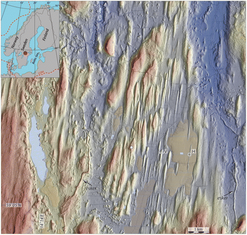
Two Hackvad drumlins were trenched from flank to flank at the sites Västergården and Hullingsåsen (Möller & Dowling Citation2016) (Fig. ). The trench across the spindle-shaped Västergården drumlin revealed in its lower part intricate architectural relations between clay diamicts and sorted sediment, the latter varying between beds of gravelly sand, laminated silt and sand and clay with silt and sand intraclasts. Sediment inter-relations suggest primary deposition of diamicts as traction till (Evans et al. Citation2006) with a lithological composition highly influenced by the local bedrock, that is, the Palaeozoic sedimentary rocks, in both its finer- and its coarser-grained components – especially the middle Cambrian clay shale – interbedded with sorted sediment deposited during ice–bed decoupling to accommodate the subglacial meltwater drainage and with bed deformation during ice–bed recoupling. Large-scale folds and thrusts suggest a post-depositional stage of glaciotectonic displacement, bringing all sediment in the lower part of the drumlin into what resembles a macro-scale glacitectonite (Evans et al. Citation2006) under both ductile and brittle compressional deformation. This phase is the initiation of drumlin formation here (Möller & Dowling Citation2016) that may be regarded as being due to “constructional deformation” (Hart et al. Citation1990; Hart Citation1997), during which subglacially shear-deformed sediments agglomerated into the drumlin, building its basal core. The upper part of the drumlin consists of massive, very firm diamict with substantially higher frequencies of crystalline rock lithologies that have travelled further at the expense of the local Palaeozoic rocks; this upper part of the drumlin is suggested to be a traction till sensu Evans et al. (Citation2006), deposited directly at the ice–bed interface during pervasive high-strain deformation.
The trench across the constant-width and megaflute-shaped Hullingsåsen drumlin (1060-m long with an elongation ratio of ~18; Fig. ) reveals an intricate sediment-architectural relation between three constituents: (i) a bluish-grey massive silty-clayey diamict, (ii) a brown massive to vaguely stratified silty–sandy diamict and (iii) beds of massive to stratified sand interbedded with the brown diamict. The diamicts’ colours and grain sizes are due to their very different lithologic compositions; the bluish-grey diamict is composed of close to 100% middle Cambrian clay shale in the gravel grade, which also is responsible for its high clay content, while the brown diamict consists of 60–85% crystalline rocks and lower Cambrian sandstone in the gravel grade. As revealed in the cross-section, the two diamicts occur in stratigraphic superposition with (i) below (ii) but are highly deformed into each other after their primary displacement [see Figure 17 in Möller and Dowling (Citation2016)] by means of compressional isoclinal folding, a late-stage displacement that we couple to the formation of the megaflute ridge. Structural measurements suggest stress from the NW on the west flank of the ridge, which is strongly oblique to its axial trend (N 9° E–S 9° W); as for the Västergården drumlin, the internal architecture at Hullingsåsen suggests “constructional deformation” as the main ridge-forming process.
The Hackvad drumlin field, displaying no obvious “seeding points” for individual drumlins as opposed to the bedrock-cored drumlins to the west and south over crystalline basement areas [“obstacle drumlins” in the terminology of Clark (Citation2010)], are thus “emergent-type” drumlins (Clark Citation2010) that possibly formed over a pre-existing flat ice–bed interface beneath which was a thick pre-existing drift sheet. We tie their formation to a thickening of the subglacial drift bed by constructional deformation (Hart Citation1997), accompanied by excavational deformation along the flanks of the emerging drumlins, shaping the separating troughs. This suggests a partial redistribution of the sediments beneath the ice–bed interface into streamlined terrain, which at Hullingsåsen is solely due to compressional glaciotectonic deformation, while at Västergården we record a first phase with a combination of compressional glaciotectonic folding and thrusting followed by emplacement of traction till over the emerging drumlin. The excavational deformation in what become inter-drumlin troughs might have been enhanced due to the energy balance along an ice–bed interface between pre-existing but with time growing bed perturbations (Hooke & Medford Citation2013), with positive energy balance over troughs leading to enhanced erosion, while negative energy balance over ridges leading to deposition (freezing or stiffening of a deforming bed).
Streamlined patches to more singularly occurring drumlins with cores of glaciolacustrine and/or glaciofluvial sediments
Sorted sediment overlain by till was described from the interior of Småland in the late nineteenth century during the first attempts at mapping the area by the Swedish Geological Survey (SGU) (Fredholm Citation1875; Hummel Citation1877), with most of the described sites centred around the town of Växjö. The insight that these deposits geomorphologically form streamlined terrain came much later with the access to aerial photography. The first description of the internal composition came from well diggings and small sandpits. It was suggested that the sub-till sorted sediments, ranging from sand and gravel to rhythmically laminated clay, were deposited during the last deglaciation but overlain by a till during a local ice margin oscillation (minimum 30 km), after which general ice recession towards the north commenced (Strandmark Citation1956, Citation1957; Daniel Citation1989, Citation1994). Any chronological proof of this assumption was not given, and Rydström (Citation1965, Citation1971) instead suggested that the sorted sediments were of older age, still with no chronological proof of this.
A better age constraint on the drumlin-core sediments, constituting glaciolacustrine delta-front and more distal deeper-water sediments as well as glaciofluvial braid-plain deposits, comes from 43 OSL datings on sediment samples retrieved from 14 machine-dug trenches (Möller & Murray Citation2015). The OSL ages fall into two groups: one older group between 48 and 56 ka and a younger one between 28 and 38 ka; both groups are thus within MIS 3 (~60–30 ka) and both correlate well with the time spans of the Ristinge and Klinholm advances, respectively, of Baltic Basin ice streams into Denmark (Houmark-Nielsen Citation2010; Möller & Murray Citation2015). The younger OSL age group is now also supported by radiocarbon datings of macrofossils embedded in glaciolacustrine sediments; a recent core drilling project into four of the sediment-cored drumlins investigated in Möller & Murray (Citation2015) has so far resulted in four radiocarbon ages between 26 and 36 cal. ka BP (Möller, in preparation; more datings are pending).
The sediment successions of the above take two geomorphological expressions in the present landscape, namely (i) isolated soft sediment-cored drumlins and (ii) larger patches of streamlined terrain on top of sorted sediment successions (Möller & Dowling Citation2015). The first category, which can be exemplified by the Grimslöv–Ströby drumlin (Fig. A), forms drumlins an order of magnitude larger than the rock-cored drumlins that occur around them. The soft core of the Grimslöv–Ströby drumlin is revealed in a recently performed core drilling in its northern tip (white dot in Fig. A); below a surface till (~3 m) is a sequence of glaciofluvial sand (~20 m) above glaciolacustrine, rhythmically laminated silt (~12 m) and then another sequence of glaciofluvial sediment (~4.5 m) ending with a ~3.5-m-thick till on top of bedrock. The total sediment succession below the ground surface is thus ~44-m-thick, of which the drumlin form encloses the upper 15–20 m [maximum height of the drumlin above the flanking glaciolacustrine sediments from the last deglaciation, plus the most common thickness of the latter which is 3–5 m (Möller Citation1987)]. A 4-m deep excavation in the western flank of the drumlin (Figs. B, ) shows highly imbricated bedding, striking WSW–ENE and dipping 88–82° towards the SSE; the sedimentary sequence comprises planar parallel-laminated gravelly sand at the base overlain by repeated sets of interbedded planar parallel-laminated medium sand and bedsets of ripple-laminated fine sand. The position and shape of this glaciolacustrine lower delta-slope/delta-toe sediment sequence (Möller & Dowling Citation2015) suggest glacial deformation from the NNW, which is slightly oblique to the drumlins-axis trend (~N–S); the sediments were isoclinally folded – and shortened – into close to vertically standing folds, with those sediments exposed in the section being the right-hand limb of such folds. The ductile deformation was replaced in a late stage by brittle trusting and top erosion followed by deposition of a ~0.8-m-thick carapace of subglacial traction till (Evans et al. Citation2006) on top of shear-laminated sand and associated small-scale drag folds (Fig. B).
Figure 16. A. Hill shaded DSM of the isolated sediment-cored Grimslöv–Ströby drumlin, rising 12 m above the surrounding glacial lake plain deposits (NE corner of Lake Åsnen, south-central Småland). Colour coding is from ~160 (reddish) to 140 (blue) m a.s.l. The white circle in the northern tip of the drumlins marks an excavated section of the drumlin (Fig. ); the white dot marks the position of a core drilling through the drumlin sediments (43 m to bedrock). LiDAR data provided by Lantmäteriverket, Sweden; ©Lantmäteriverket i212/927. B. Sediment log from the trench marked by the white circle in (A), showing glaciotectonically displaced glaciolacustrine sediments below a draping till. Lithofacies codes according to Table . Green planes in stereonet indicate strike and dip of high-angle bedding surfaces, while the red plane represents strike and dip of the thrust plane in the lower part of the section. Glaciotectonic stress was from the NNW. OSL ages are according to Möller & Murray (Citation2015).
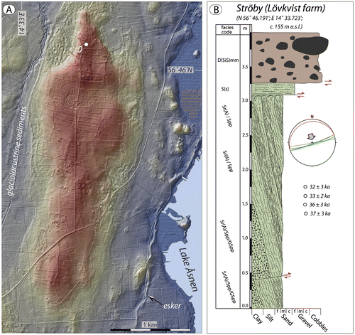
Figure 17. Glaciolacustrine sediment sequence forming the core of the Grimslöv–Ströby drumlin (Fig. ). The sediments are glaciotectonically folded from the NNW (drumlin axis N–S); shown section is the right limb of an isoclinal fold (up of the sediment sequence is to the right) with primary bed contacts standing close to vertically. The fold is cut off by glacial erosion; the sediments beneath the horizontal shear surface (hatched white line) display shear lamination in a 10–15-cm-thick horizon, and below these are small-scale drag folds. On top is a ~0.7-m-thick diamict, interpreted as a subglacial traction till. This till forms a carapace, draping the sorted sediment core of the drumlin. OSL ages of the glaciolacustrine sediments are between 32 and 37 ka (n = 4). Per Möller for scale is 1.68 m.
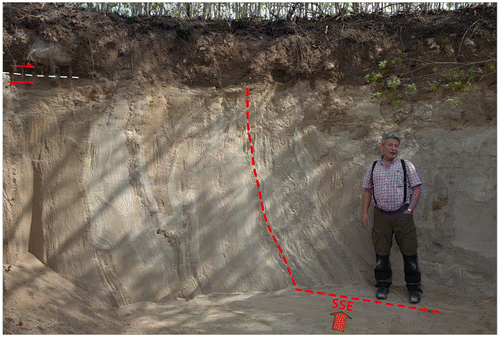
The second category of soft-cored streamlined terrain in south-central Småland, as stated above, is the larger patches of streamlined terrain on top of sorted sediment successions, with their occurrence first being evident with the introduction of hill-shaded DSMs. An example of this is the Rydaholm-Upplid area (Fig. ). The area is over ~30 km2 and is a flat but streamlined till plain, with the streamlined features trending from 7° to 9°N [146 features mapped; mean height = 3.2 m and mean elongation ratio = 3.4 (Möller & Dowling Citation2015)]. Well logs from the SGU well archive report sediment thickness between 16 and 52 m from ground surface to bedrock over the streamlined area. We have recently performed core drilling in Upplid (white point in Fig. ), which gave 18 m of sand and gravelly sand below 3 m of surface till. This drilling was terminated for technical reasons, but a nearby well log indicates ~50 m of sediment above the bedrock at this site.
Figure 18. Hill shaded DSM of streamlined terrain imprinted on widely distributed glaciofluvial sediments between Lake Rymmen and Rydaholm, ~35 km WNW of Växjö, south-central Småland (the red dot in the upper left corner of the inset map shows the location of the area in a regional context). Colour coding is from ~250 (reddish) to 160 (bluish) m a.s.l. The streamlined higher terrain is bounded to the north by a 10–20 m high scarp to lower terrain, and to the SW the streamlined plateau is cut by a 0.8–1-km-wide and~30-m-deep valley hosting a glaciofluvial esker train [resembling the “hummocky corridors” of Peterson et al. (Citation2017, Citation2018)]. The white dot indicates the position of a core drilling performed recently at Upplid, reaching 18 m below the ground surface. The white circle (R) is the position of a logged sediment trench (inset in lower right corner) with OSL ages according to Möller & Murray (Citation2015). LiDAR data provided by Lantmäteriverket, Sweden; ©Lantmäteriverket i212/927.
![Figure 18. Hill shaded DSM of streamlined terrain imprinted on widely distributed glaciofluvial sediments between Lake Rymmen and Rydaholm, ~35 km WNW of Växjö, south-central Småland (the red dot in the upper left corner of the inset map shows the location of the area in a regional context). Colour coding is from ~250 (reddish) to 160 (bluish) m a.s.l. The streamlined higher terrain is bounded to the north by a 10–20 m high scarp to lower terrain, and to the SW the streamlined plateau is cut by a 0.8–1-km-wide and~30-m-deep valley hosting a glaciofluvial esker train [resembling the “hummocky corridors” of Peterson et al. (Citation2017, Citation2018)]. The white dot indicates the position of a core drilling performed recently at Upplid, reaching 18 m below the ground surface. The white circle (R) is the position of a logged sediment trench (inset in lower right corner) with OSL ages according to Möller & Murray (Citation2015). LiDAR data provided by Lantmäteriverket, Sweden; ©Lantmäteriverket i212/927.](/cms/asset/402a8758-7138-465e-9c49-0a0f90ddd89a/sgff_a_1441903_f0018_oc.gif)
Insight into the upper part of the sediment succession beneath the streamlined till plain is revealed in a small sand pit ~2 km NW of Rydaholm (white circle marked by “R” in Fig. ), exposing 5.3 m of sorted sediment beneath a 1.7-m-thick diamict (inset log in Fig. ). The sorted sediment succession predominantly consists of parallel-laminated medium to fine sand with floating outsized clasts (usually 3–15 cm; MPS 30 cm), interbedded with thicker units (10–40 cm) of massive gravelly sand. The beds within the sorted sediment succession plunge ~18° towards the WSW. The site-average OSL age for the sorted sediment sequence is 49 ± 3 ka, based on three OSL ages (Möller & Murray Citation2015), that is, within the frame of the older MIS 3 OSL age group. The sorted sedimentary succession is interpreted as a subaqueous delta-front deposit, the sedimentary structures suggesting overall deposition from turbidity currents down a delta slope. The thin planar-laminated beds suggest traction deposition after fallout from suspension, with synsedimentary deposition of avalanching coarser clasts, whereas the thicker normally graded and massive beds suggest direct suspension settling from fully turbulent flows or freezing of high-density flows where the coarser clasts were held in suspension due to dispersive pressures (e.g., Lowe Citation1982; Postma et al. Citation1988). The succession ends with a sharp boundary with a matrix-supported, massive diamict, bearing boulders of up to 80 cm, interpreted as traction till (Evans et al. Citation2006).
From these few examples of the soft-sediment-cored drumlins in central south Småland [all sites comprehensively described in Möller & Murray (Citation2015)], it is evident that these form “part-till / part-sorted sediment” transitional to “mainly sorted sediment” drumlins in the terminology of Stokes et al. (Citation2011), having two constituents with unconformable contacts in between them. From the compositions and internal architectures of drumlin cores and the character of the contact zone between core sediments and capping diamict (till carapace) it is concluded (Möller & Murray Citation2015; Möller & Dowling Citation2015) that the streamlined terrain and the individual drumlins described here are mainly formed by erosion. The core sediments were primarily deposited as glaciofluvial braid-plain sediments (sandur) and as glaciolacustrine deposits, the latter laid down both in delta-front positions and more proximal to distal deeper-water sediment, all emplaced much earlier (MIS 3) than the last LGM deglaciation. The drumlin-core sediments thus predate their drumlinization and the main sediment bulk of the drumlins-to-be thus carries no information regarding either the drumlin-forming mechanisms per se or the subglacial environments in which these were later formed. However, from the interrelationship between core sediments and the draping till carapace, the conclusion is that erosion into pre-existing sediments was the main drumlin-forming process here, in combination with glaciotectonic deformation to varying depths depending on the varying sediment rheology of each site. Erosion and deformation reshaped any type of original morphology (undulating or bumpy to flat) of the once proglacially deposited sediment into streamlined landforms/landform areas, followed by deposition of a form-draping till [see comprehensive discussion on formative processes in Möller & Dowling (Citation2015)].
Discussion – monogenetic formation versus process equifinality
From three of the above examples of glaciated terrain in Sweden, which by any geomorphic criteria used by glacial geomorphologists should be classified as ribbed moraine by their exterior form, we find that internal architectures and compositions suggest different process environments during their formation, in summary:
| • | Subglacial folding and/or thrust stacking of sediment into perpendicular-to-ice-flow proto-ridges at infra-marginal rheologic transitional boundaries between deforming and non-deforming sediment beneath the ice–bed interface, in turn leading to lee-side cavity sediment infill distal to the proto ridge (Niemisel genetic-type ribbed moraine); | ||||
| • | Stacked sequences of debris-flow sediments, filling in depressions between ice-cored moraines with controlled distribution in frontally stagnated ice which left a landscape of moraine ridges after landscape inversion (precursor ridges). The pre-LGM formed landscape was remolded later by overriding ice when the protective cold-based regime changed to a warm-based regime at the ice–bed interface (Rogen genetic-type ribbed moraine); and | ||||
| • | Active ice-phase zonation of debris-rich ice during the marginal transition from warm-based to cold-based conditions. These zones of debris-loaded ice (moraine ridge “embryos”) accreted in the proximal direction as the marginal zone stagnated; the englacial debris was eventually passively released, dominantly as melt-out till, upon in situ melting of the stacked ridge “embryos” (Åsnen genetic-type ribbed moraine). | ||||
As discussed in the introduction, the process-based “instability theory” (e.g., Clark, Citation2010; Stokes et al. Citation2013) does indeed produce fields of ribbed moraine features with a “real-world” appearance in numerical model runs (e.g., Fowler Citation2000; Schoof Citation2007; Chapwanaya et al. Citation2011). One significant implication of the physics contained within these models is that there was a deforming-bed sediment flux at and below the ice–bed interface with more sediment being transported into than out of the emergent bedforms (i.e., the “moraine ribs”; e.g., Clark Citation2010). However, none of the sedimentologically deduced formative models presented above indicate that instability physics was the modus operandi for the formation of the ribbed moraine areas covered in this paper. That said, these case studies do not falsify the “instability theory” as a physical model, but they do imply that this theory is not applicable to landform formations in the described case studies. We thus conclude that ribbed moraine is a glaciogenic landform pattern that can form from a number of different processes – that is, equifinality – in various physical settings, and that the term “ribbed moraine” should be used as a more general morphological term for describing a landform pattern without any specified genetic bearing. If part of the community of glacial geomorphology researchers wants to reserve the term “ribbed moraine” solely for moraine ridges formed by the processes associated with “instability theory”, then it must first be documented from the internal composition and sediment architecture that such ridges actually exist. If so, the other types of ribbed moraine must be given another label. However, making such a genetic-type differentiation based on shape and size mapping from aerial photos, satellite images or DSMs alone will be difficult.
An argument for the validity of the “instability theory” is that the metrics taken from a very large population of ribbed moraines plot in one mode. This unimodal distribution suggests a continuum in shape and size over a large size spectrum, which should also suggest one common process for ribbed moraine formation (e.g., Dunlop et al. Citation2008) – as for streamlined terrain (Ely et al. Citation2016). If there were different processes of ribbed moraine formation, it is argued that the metrics for different genetic-type moraines should plot as separate groups (a non-continuum).
We explored this argument by measuring the metrics of ribbed moraine in our three different regions, whose internal composition and architecture suggest that they represent three distinctly different genetic types of ribbed moraine. As is evident from our morphological population statistics, plotted in Figure , the three types of ribbed moraine do not plot as clearly individual distributions and could be taken as one non-differentiated population as part of a form continuum. However, when differentiated into their three geographic populations, Niemisel ribbed moraine ridges are higher, wider and longer than the Åsnen ribbed moraine ridges, while the Indor (Rogen) ribbed moraine ridges plot in between the two (Fig. (D–F)). Thus they are part of the same continuum in that they were formed in or by the subglacial environment but, as argued here based on the sedimentology, are in fact three separate genetic populations that happen to have very similar morphological expressions due to the common location of formation and the common ice-sediment physics that govern the processes.
A further consideration is that it has been shown that large populations are no guarantee of meaningful correlative relationships or distributive interpretations in a number of other fields (e.g., Wang Citation1992; Lantz Citation2013; Ekbia et al. Citation2015; Nagler & Tucker Citation2015). To quote Lantz (Citation2013), “significance in the statistical sense has little to do with significance in the common practical sense … the results of studies based on large samples are often characterised by extreme statistical significance despite small or even trivial effect sizes”. Furthermore, when samples are drawn from the same population (e.g., features created subglacially), the variance between these samples will become smaller as the size of the population increases (Hagen Citation1997, p. 20). This expected reduction in variance is borne out by the morphological continuum seen in the very large landform morphology data-sets that are now common in studies of glacial geomorphology. However, the observed continuum can only be said to be a morphological one. There is no statistical reason to assume that it is also a process continuum without evidence to support this. Further problems arise if correlations are drawn between indices that have a common component (Kronmal Citation1993). The use of feature elongation ratios in geomorphological analyses is an example of this that has resulted in concepts such as the idea that a length–width elongation ratio boundary is present in drumlins, when no such boundary exists in reality (Dowling et al. Citation2015). Therefore, with regard to ribbed moraine formation, we argue that different and unrelated processes lead to landforms that have a very similar morphology, that is, equifinality. This equifinality of shape results in distributions that are part of a continuum, particularly when plotted as large populations.
From our case-study examples of streamlined terrain in Sweden, it is clear that the dominant type is rock-cored drumlins (crag-and-tail features), while soft-cored drumlins of various sorts are much less common. We find that:
| • | Rock-cored drumlins were built from stoss-side plastering of till on bedrock knobs, combined with lee-side cavity infill in the distal direction by various sediments ranging from glaciofluvial coarse- to fine-grained sediment and diamictic sediment gravity flow sediments and traction till at cavity closures, that is, mainly depositional to their character; | ||||
| • | The internal architecture of soft-core-type streamlined terrain suggests that drumlin ridges are due to constructional sediment deformation, while intervening troughs are due to excavational deformation; | ||||
| • | In some areas of Sweden we find preserved, more or less, large patches of pre-LGM sorted sediment successions with a streamlined top surface. Their internal architecture suggests that they are pure erosional drumlins draped with a thin till carapace and possibly a thin deformational zone between undisturbed sediment and the capping till. | ||||
In the case of streamlined terrain, which often has considerable morphologic difference between features at local landscape scale whilst still remaining part of the drumlin continuum on regional scale, we argue that the morphology is a product of different processes or process combinations of erosion, deformation and/or accumulation in the subglacial system. The size and shape of drumlins tend towards the most efficient obstacle shape and thus bedform on which sliding can take place. The logic for this in the first order is that obstacles enhance sliding speed by increasing melting and plastic flow. However, if an obstacle is too “rough”, the increase in basal drag counteracts this. Therefore the subglacial system finds an efficiency equilibrium whereby an obstacle is shaped so that it enhances flow with a minimum of drag; that is, the typical streamlined form is the result of a positive feedback cycle that tends towards efficiency.
Further, the relatively simple mechanics of the instability theory of Clark (Citation2010) and Stokes et al. (Citation2013), which suggest that sediment (till) subglacially sheared in a deforming bed and flowing in a larger quantity into than out of a bed perturbation, and thus with time producing an emergent, depositional-type drumlin, are not supported from field observations from the modern drumlin-forming environment at Múlajökul on Iceland (e.g., McCracken et al. Citation2016; Iverson et al. Citation2017). The results from the Múlajökul laboratory and field measurements on shear strength in till and till fabric rather suggests that till is deposited more uniformly over the subglacial bed during surge events, while the effective-stress distribution at the ice–bed interface during quiescent flow phases causes erosion at the heads and flanks of bed perturbations, making the drumlins grow in height and migrate down glacier. Further, their model gives support of the erodent layer hypothesis (Eyles et al. Citation2016) with formation of purely erosional drumlins in absence of deforming bed deposition at surge cycles. The Múlajökul studies thus give further evidence to the complex nature of drumlin formation, i.e., equifinality.
Conclusions
This paper draws upon case studies that are located across a wide area of the former palaeo-bed of the Fennoscandian Ice Sheet. Based upon a combination of statistics on geomorphological shape and detailed sedimentological studies, we argue that:
| (1) | The subglacial environment contains a suite of different ice-sediment physics that, irrespective of this, leads to an equifinality of shape of some subglacial landforms (ribbed moraine and streamlined terrain) despite the differences in the detail of their process of formation. | ||||
| (2) | Large morphological data-sets of subglacial landforms can only be used to classify features as part of a formation continuum, or not, when they are used in conjunction with the sedimentology of the said landforms. | ||||
| (3) | Ribbed moraines in the Swedish context are likely formed due to at least three different combinations of processes. It has yet to be shown which, if any, of these combinations can be associated with instability theory. | ||||
| (4) | Drumlins are formed through a suite of different processes, of which instability propagation is only one. | ||||
Disclosure statement
No potential conflict of interest was reported by the authors.
Funding
This study partly builds on research done within projects financially supported by research grants from the Geological Survey of Sweden [project nmber 03-1145/2000], [project nmber 60-1406-2006] and [project nmber 36-1638/2014].
Acknowledgements
We are grateful for comments from reviewers Ola Fredin and Roger LeB Hooke, which improved the paper.
References
- Aario, R., 1977: Classification and terminology of morainic landforms in Finland. Boreas 6, 87–100.
- Aber, J.S., Croot, D.G. & Fenton, M.M., 1989: Glaciotectonic Landforms and Structures. Kluwer Academic Publishing, Dortrecht. 200 p.10.1007/978-94-015-6841-8
- Aylworth, J.M. & Shilts, W.W., 1989: Bedforms of the Keewatin Ice Sheet, Canada. Sedimentary Geology 62, 407–428.10.1016/0037-0738(89)90129-2
- Benn, D.I., 1994: Fabric shape and interpretation of sedimentary fabric data. Journal of Sedimentary Research A64, 910–915.
- Benn, D.I. & Evans, J.A., 1996: The interpretation and classification of subglacially-deformed materials. Quaternary Science Reviews 15, 23–52.10.1016/0277-3791(95)00082-8
- Berglund, B., 1979: The deglaciation of southern Sweden 13500–10000 B.P. Boreas 10, 323–362.
- Beskow, G., 1935: Praktiska och kvartärgeologiska resultat av grusinventeringen i Norrbotten. Geologiska Föreningens i Stockholm Förhandlingar 57, 120–123.
- Björck, S. & Möller, P., 1987: Late Weichselian environmental history in southeastern Sweden during the deglaciation of the Scandinavian ice sheet. Quaternary Research 28, 1–37.10.1016/0033-5894(87)90030-5
- Boulton, G.S., 1982: Subglacial processes and the development of glacial bedforms. In N.W. Davidson-Arnott & B.D. Fahey (eds.): Research in Glacial, Glacio-fluvial and Glacio-lacustrine Systems, 1–32. Proceedings of the 6th Guelph Symposium on Geomorphology, 1980. Geo Books, Norwich.
- Boulton, G.S., 1987: A theory of drumlin formation by subglacial sediment deformation. In J. Menzies & J. Rose (eds.): Drumlin Symposium, 25–80. A. A. Balkema, Rotterdam.
- Boulton, G.S. & Hindmarsh, R.C.A., 1987: Sediment deformation beneath glaciers – rheology and geological consequences. Journal of Geophysical Research 92(B9), 9059–9082.10.1029/JB092iB09p09059
- Chapwanya, M., Clark, C.D. & Fowler, A.C., 2011: Numerical computations of a theoretical model of ribbed moraine formation. Earth Surface Processes and Landforms 36, 1105–1112.10.1002/esp.v36.8
- Clark, C.D., 2010: Emergent drumlins and their clones: from dilatancy to flow instabilities. Journal of Glaciology 56, 1011–1025.10.3189/002214311796406068
- Clark, C.D. & Meehan, R.T., 2001: Subglacial bedform geomorphology of the Irish Ice Sheet reveals major configuration changes during growth and decay. Journal of Quaternary Science 16, 483–496.10.1002/(ISSN)1099-1417
- Clark, C.D., Hughes, A.L.C., Greenwood, S.L., Spagnolo, M. & Ng, F.S.L., 2009: Size and shape characteristics of drumlins, derived from a large sample, and associated scaling laws. Quaternary Science Reviews 28, 677–692.10.1016/j.quascirev.2008.08.035
- Cleland, C.E., 2013: Common cause explanation and search for a smoking gun. Geological Society of America Special Papers 502, 1–9.
- Cowan, W.R., 1968: Ribbed moraine: till-fabric analysis and origin. Canadian Journal of Earth Sciences 5, 1145–1159.10.1139/e68-112
- Daniel, E., 1989: Beskrivning till jordartskartan 5E Växjö SV. Sveriges geologiska undersökning Ae 101, 77 p.
- Daniel, E., 1994: Beskrivning till jordartskartan 5E Växjö SO. Sveriges geologiska undersökning Ae 119, 77 p.
- Doane, D.P., 1976: Aesthetic frequency classifications. American Statistician 30, 181–183.
- Dowling, T.P.F., 2016: The drumlin problem. Streamlined subglacial bedforms in southern Sweden. LUNDQUA thesis 180. Department of Geology/Quaternary Sciences, Lund University, 172 p.
- Dowling, T.P.F., Alexanderson, H. & Möller, P., 2013: The new high resolution LiDAR digital height model (‘Ny Nationell Höjdmodell’) and its application to Swedish Quaternary geomorphology. GFF 135, 145–151.10.1080/11035897.2012.759269
- Dowling, T.P.F., Möller, P. & Spagnolo, M., 2016: Rapid subglacial streamlined bedform formation at a calving bay margin. Journal of Quaternary Science 31, 879–892.
- Dowling, T.P.F., Spagnolo, M. & Möller, P., 2015: Morphometry and core type of streamlined bedforms in southern Sweden from high resolution LiDAR. Geomorphology 236, 54–63.10.1016/j.geomorph.2015.02.018
- Dunlop, P. & Clark, C.D., 2006: The morphological characteristics of ribbed moraine. Quaternary Science Reviews 25, 1668–1691.10.1016/j.quascirev.2006.01.002
- Dunlop, P., Clark, C.D. & Hindmarsh, C.A., 2008: Bed ribbing instability explanation. Testing a numerical model of ribbed moraine formation arising from coupled flow of ice and subglacial sediment. Journal of Geophysical Research 113(F3), 1–15.
- Ekbia, H., Mattioli, M., Kouper, I., Arave, G., Ghazinejad, A., Bowman, T., Suri, V.R., Tsou, A., Weingart, S. & Sugimoto, C.R., 2015: Big data, bigger dilemmas: a critical review. Journal of the Association for Information Science and Technology 66, 1523–1545.10.1002/asi.2015.66.issue-8
- Ely, J.C., Clark, C.D., Spagnolo, M., Stokes, C.R., Greenwood, S.L., Hughes, A.C.L., Dunlop, P. & Hess, D., 2016: Do subglacial bedforms comprise a size and shape continuum? Geomorphology 257, 108–119.10.1016/j.geomorph.2016.01.001
- Evans, D.J.A., Philips, E.R., Hiemstra, J.F. & Auton, C.A., 2006: Subglacial till: formation, sedimentary characteristics and classification. Earth-Science Reviews 78, 115–176.10.1016/j.earscirev.2006.04.001
- Everest, J., Bradwell, T. & Golledge, N., 2005: Subglacial landforms of the tweed palaeo-ice stream. The Scottish Geographical Magazine 121(2), 163–173.10.1080/00369220518737229
- Eyles, N., Eyles, C.H. & Miall, A.D., 1983: Lithofacies types and vertical profile models; an alternative approach to the description and environmental interpretation of glacial diamict and diamictite sequences. Sedimentology 30, 393–410.10.1111/sed.1983.30.issue-3
- Eyles, N., Putkinen, N. & Arbelaez-Moreno, L., 2016: Erosional origin of drumlins and megaridges. Sedimentary Geology 238, 2–23.10.1016/j.sedgeo.2016.01.006
- Fannon, J.S., Fowler, A.C. & Moyles, I.R., 2017: Numerical simulations of drumlin formation. Proceedings of the Royal Society A 473, 20170220.10.1098/rspa.2017.0220
- Fisher, T.G. & Shaw, J., 1991: A depositional model for Rogen moraine, with examples from the Avlon Peninsula, Newfoundland. Canadian Journal of Earth Sciences 29, 669–686.
- Fowler, A., 2000: An instability mechanism for drumlin formation. In A. Maltman, M.J. Hambrey & B. Hubbard (eds.): Deformation of Glacial Materials. Special Publication from the Geological Society 176, 307–319. The Geological Society, London.
- Fredholm, K.A., 1875: Några iakttagelser öfver skiktade gruslager bland krosstensgrus i Småland. Geologiska Föreningens i Stockholm Förhandlingar 2, 522–525.
- Fromm, E., 1965: Beskrivning av jordartskarta över Norrbottens län nedan lappmarksgränsen. Sveriges geologiska undersökning Ca 39, 232 p.
- Gillberg, G., 1976: Drumlins in southern Sweden. Bulletin of the Geological Institution of the Uppsala University NS 6, 125–189.
- Glückert, G., 1973: Two large drumlin fields in central Finland. Fennia 120. 37 p.
- Gravenor, C.P. & Kupsch, W.O., 1959: Ice disintegration features in western Canada. Journal of Geology 67, 48–64.10.1086/626557
- Hagen, R.L., 1997: In praise of the null hypothesis statistical test. American Psychologist 52, 15–24.10.1037/0003-066X.52.1.15
- Hart, J.K., 1997: The relationship between drumlins and other forms of subglacial glaciotectonic deformation. Quaternary Science Reviews 16, 93–107.10.1016/S0277-3791(96)00023-6
- Hart, J.K., Hindmarsch, R.C.A. & Boulton, G.S., 1990: Different styles of subglacial glaciotectonic deformation in the context of the Anglian Ice Sheet. Earth Surface Processes and Landforms 15, 227–241.10.1002/(ISSN)1096-9837
- Hättestrand, C., 1997a: Ribbed moraines in Sweden – distribution pattern and palaeoglaciological implications. Sedimentary Geology 111, 41–56.10.1016/S0037-0738(97)00005-5
- Hättestrand, C., 1997b: The glacial geomorphology of central and northern Sweden. Sveriges geologiska undersökning Ca 85, 47 p.
- Hättestrand, M., 2008: Vegetation and climate during Weichselian ice free intervals in northern Sweden – Interpretation from fossil and modern pollen records. Dissertation from the Department of Physical Geography and Quaternary Geology no 15. Stockholm University. 35 pp.
- Hillefors, Å., 1975: Contribution to the knowledge of the chronology of the deglaciation of western Sweden with special reference to the Gothenburg moraine. Svensk Geografisk Årsbok 51, 70–81.
- Hillefors, Å., 1979: Deglaciation models from the Swedish west coast. Boreas 8, 153–169.
- Hillier, J.K., Smith, M.J., Clark, C., Stokes, C. & Spagnolo, M., 2013: Subglacial bedforms reveal an exponential size–frequency distribution. Geomorphology 190, 82–91.10.1016/j.geomorph.2013.02.017
- Hindmarsh, R.C.A., 1998a: Drumlinization and drumlin-forming instabilities: viscous till mechanisms. Journal of Glaciology 44, 293–314.10.1017/S002214300000263X
- Hindmarsh, R.C.A., 1998b: The stability of a viscous till sheet coupled with ice flow, considered at wavelengths less than the ice thickness. Journal of Glaciology 44, 285–292.10.1017/S0022143000002628
- Hindmarsh, R.C.A., 1999: Coupled ice-till dynamics and the seeding of drumlins and bedrock forms. Annals of Glaciology 28, 221–230.10.3189/172756499781821931
- Hooke, R.LeB & Medford, A. 2013: Are drumlins a product of a thermos-mechanical instability? Quaternary Research 79, 458–464.
- Hjort, J. & Marmion, M., 2008: Effects of sample size on the accuracy of geomorphological models. Geomorphology 102, 341–350.10.1016/j.geomorph.2008.04.006
- Hoppe, G., 1948: Isressessionen från Norrbottens kustland. Geographica 20, 1–112.
- Hoppe, G., 1959: Glacial morphology and inland ice recession in northern Sweden. Geografiska Annaler 41, 193–212.10.1080/20014422.1959.11907951
- Houmark-Nielsen, M., 2010: Extent, age and dynamics of marine Isotope Stage 3 glaciations in the southwestern Baltic Basin. Boreas 39, 343–359.10.1111/bor.2010.39.issue-2
- Hughes, O.L., 1964: Surficial geology, Nichicun-Kaniapiskau map-area, Quebec. Geological Survey of Canada Bulletin 106, 20 p.
- Hughes, A.C.L., Gyllencreutz, R., Lohne, Ø.S., Mangerud, J. & Svendsen, J.I., 2015: The last Eurasian ice sheet – a chronological database and time-slice reconstruction, DATED-1. Boreas 45, 1–45.
- Hummel, D., 1877: Beskrifning till kartbladet “Huseby”. Sveriges geologiska undersökning Ab 1, 23 p.
- Hunter, J.D., 2007: Matplotlib: A 2D graphics environment. Computing in Science & Engineering 9, 90–95.10.1109/MCSE.2007.55
- Iverson, N.R., McCracken, R.G., Zoet, L.Z., Benediktsson, Í.Ö., Schomacker, A., Johnson, M.D. & Woodard, J., 2017: A theoretical model of drumlin formation based on observations at Múlajökul, Iceland. Journal of Geophysical Research: Earth Surface 122, 2302–2323. doi:10.1002/2017JF004354.
- Johnson, M.D., Fredin, O., Ojala, A.E.K. & Peterson, G., 2015: Unraveling Scandinavian geomorphology: the LiDAR revolution. GFF 137, 245–251.10.1080/11035897.2015.1111410
- Kleman, J., 1990: On the use of glacial striae for reconstruction of paleo-ice sheet flow patterns – with application to the Scandinavian ice sheet. Geografiska Annaler 72A, 217–236.
- Kleman, J. & Hättestrand, C., 1999: Frozen-bed Fennoscandian and Laurentide ice sheets during the Last Glacial maximum. Nature 402, 63–66.10.1038/47005
- Kleman, J., Hättestrand, C., Borgström, L. & Stroeven, A., 1997: Fennoscandian palaeoglaciology reconstructed using a glacial geological inversion model. Journal of Glaciology 43, 283–299.10.1017/S0022143000003233
- Knight, J. & McCabe, A.M., 1997: Identification and significance of ice-flow-transverse subglacial ridges (Rogen moraines) in northern central Ireland. Journal of Quaternary Science 12, 519–524.10.1002/(ISSN)1099-1417
- Kronmal, R.A., 1993: Spurious correlation and the fallacy of the ratio standard revisited. Journal of the Royal Statistical Society, Series A 156, 379–392.10.2307/2983064
- Lagerlund, E., Knutsson, G., Åmark, M., Hebrand, M., Jönsson, L.-O., Karlgren, B., Kristiansson, J., Möller, P., Robison, J.M., Sandgren, P., Terne, T. & Waldemarsson, D., 1983: The deglaciation pattern and dynamics in south Sweden, a preliminary report. LUNDQUA report 24, 1–7. Department of Geology, Lund University, Sweden.
- Lantz, B., 2013: The large sample size fallacy. Scandinavian Journal of Caring Sciences 27, 487–492.10.1111/scs.2013.27.issue-2
- Lindén, M. & Möller, P., 2005: Marginal formation of De Geer moraines and their implication on the dynamics of grounding-line recession. Journal of Quaternary Science 20, 113–133.10.1002/jqs.v20:2
- Lindén, M., Möller, P. & Adrielsson, L., 2008: Ribbed moraine formed by subglacial folding, thrust stacking and lee-side cavity infill. Boreas 37, 102–131.10.1111/bor.2008.37.issue-1
- Lindén, M., Möller, P., Björck, S. & Sandgren, P., 2006: Holocene shore displacement and deglaciation chronology in Norrbotten, Sweden. Boreas 35, 1–22.10.1080/03009480500359160
- Lowe, D.R., 1982: Sediment gravity flows: II. Depositional models with special reference to the deposits of high-density turbidity currents. Journal of Sedimentary Petrology 52, 279–297.
- Lundqvist, J., 1969: Problems of the so-called Rogen moraine. Sveriges geologiska undersökning C 648, 32 p.
- Lundqvist, J., 1970: Studies of drumlin tracts in central Sweden. Acta Geographica Lodzientia 24, 317–326.
- Lundqvist, J., 1981: Moraine morphology. Terminological remarks and regional aspects. Geografiska Annaler 63A, 127–137.
- Lundqvist, J., 1989: Rogen (ribbed) moraine – identification and possible origin. Sedimentary Geology 62, 127–138.
- Lundqvist, J., 1997: Rogen moraine – an example of two-step formation of glacial landscapes. Sedimentary Geology 111, 27–40.10.1016/S0037-0738(97)00004-3
- Mangerud, J., Gyllencreutz, R., Lohne, Ö. & Svendsen, J.I., 2011: Glacial history of Norway. In J. Ehlers, P. L. Gibbard & P. H. Hughes (eds.): Quaternary Glaciations – Extent and Chronology – A Closer Look, Vol. 15, chap. 22, 279–298. Developments in Quaternary Science. Elsevier, Amsterdam.10.1016/B978-0-444-53447-7.00022-2
- Mark, D.M., 1973: Analysis of axial orientation data, including till fabrics. Geological Society of America Bulletin 84, 1369–1374.10.1130/0016-7606(1973)84<1369:AOAODI>2.0.CO;2
- McCracken, R.G., Iverson, N.R., Benediktsson, Í.Ö., Schomacker, A., Zoet, L.Z., Johnson, M.D., Hooyer, T.S. & Ingólfsson, Ò., 2016: Origin of the active drumlin field at Múlajökul, Iceland: new insights from shear and consolidation patters. Quaternary Science Reviews 148, 243–260.10.1016/j.quascirev.2016.07.008
- McKinney, W., 2010: Data structures for statistical computing in python. Proceedings of the 9th Python in Science Conference, 51–56.
- Menzies, J., 1979: A review on the literature on the formation and location of drumlins. Earth Science Reviews 14, 315–359.10.1016/0012-8252(79)90093-X
- Möller, P., 1987: Moraine morphology, till genesis, and deglaciation pattern in the Åsnen area, south-western Småland, Sweden. LUNDQUA thesis 20. Department of Geology, Lund University, Sweden. 146 p.
- Möller, P., 2006: Rogen moraine: an example of glacial reshaping of pre-existing landforms. Quaternary Science Reviews 25, 362–389.10.1016/j.quascirev.2005.01.011
- Möller, P., 2010: Melt-out till and ribbed moraine formation, a case study from south Sweden. Sedimentary Geology 232, 161–180.10.1016/j.sedgeo.2009.11.003
- Möller, P., Anjar, J. & Murray, A.S. 2013: An OSL-dated sediment sequence at Idre, west-central Sweden, indicates ice-free conditions in MIS 3. Boreas 42, 25–42.
- Möller, P. & Dowling, T.P.F., 2015: The importance of thermal boundary transitions on glacial geomorphology; mapping of ribbed/hummocky moraine and streamlined terrain from LiDAR, over Småland, south Sweden. GFF 137(4), 252–283.10.1080/11035897.2015.1051736
- Möller, P. & Dowling, T.P.F., 2016: Streamlined subglacial bedforms on the Närke plain, south-central Sweden – areal distribution, morphometrics, internal architecture and formation. Quaternary Science Reviews 146, 182–215.10.1016/j.quascirev.2016.04.007
- Möller, P. & Murray, A.S., 2015: Drumlinised glaciofluvial and glaciolacustrine sediments on the Småland peneplain, South Sweden – new evidence on the growth and decay history of the Fennoscandian Ice Sheets during MIS 3. Quaternary Science Reviews 122, 1–29.10.1016/j.quascirev.2015.04.025
- Munro-Stasiuk, M.J., 2000: Rhythmic till sedimentation: evidence for repeated hydraulic lifting of a stagnant ice mass. Journal of Sedimentary Research 70, 94–106.10.1306/2DC40901-0E47-11D7-8643000102C1865D
- Nagler, J. & Tucker, J.A., 2015: Drawing inferences and testing theories with big data. PS. Political Science & Politics 48, 84–88.10.1017/S1049096514001796
- Nilsson, T., 1996: Process- och miljötolkning av sedimentationen i en subglacial läsideskavitet, Järnavik, Blekinge. Bachelor’s thesis at the Department of Geology, no. 66, Lund University. 43 p. (http://lup.lub.lu.se/luur/download?func¼downloadFile&recordOId¼2369920&fileOId¼3131858).
- Ojala, A.E.K. & Sarala, P., 2017: LiDAR – rapid developments in remote sensing of geological features. Bulletin of the Geological Survey of Finland 89, 61–63.10.17741/bgsf
- Oliphant, T.E., 2007: Python for scientific computing. Computing in Science & Engineering 9, 10–20.10.1109/MCSE.2007.58
- Peterson, G., Johnson, M.D., Dahlgren, S., Påsse, T. & Alexanderson, H., 2018: Genesis of hummocks found in tunnel valleys: an example from Hörda, southern Sweden. GFF, this issue.
- Peterson, G., Johnson, M.D. & Smith, C.A., 2017: Glacial geomorphology of the south Swedish uplands – focus on the spatial distribution of hummock tracts. Journal of Maps 13(2), 534–544.10.1080/17445647.2017.1336121
- Postma, G., Nemec, W. & Kleinspehn, K.L., 1988: Large floating clasts in turbidites: a mechanism for their emplacement. Sedimentary Geology 58, 47–61.10.1016/0037-0738(88)90005-X
- Prest, V.K., 1968: Nomenclature of moraines and ice-flow features as applied to the glacial map of Canada. Geological Survey of Canada Paper 67–57, 32 p.
- Rose, J. & Letzer, J., 1977: Superimposed drumlins. Journal of Glaciology 18, 471–480.10.1017/S0022143000021146
- Rydström, R., 1965: Kvartärgeologiska studier inom Värend, Kronobergs län. Unpublished licentiate thesis, Department of Quaternary Geology, Lund University, Lund, Sweden. 104 pp.
- Rydström, R., 1971: The Värend district during the last deglaciation. Geologiska Föreningens i Stockholm Förhandlingar 93, 537–552.
- Schoof, C., 2007: Pressure-dependent viscosity and interfacial instability in coupled ice-sediment flow. Journal of Fluid Mechanics 570, 407–416.
- Shaw, J., 1979: Genesis of the Sveg till and Rogen moraines of central Sweden: a model of basal melt out. Boreas 8, 409–426.
- Shaw, J., 1982: Melt out till in the Edmonton area, Alberta, Canada. Canadian Journal of Earth Sciences 19, 1548–1569.10.1139/e82-134
- Shaw, J., 1983a: Drumlin formation related to inverted melt-water erosional marks. Journal of Glaciology 29, 461–479.10.1017/S0022143000030367
- Shaw, J., 1983b: Forms associated with boulders in melt-out till. In E.B. Evenson, C. Schluchter & J. Rabassa (eds.): Tills and Related Deposits, 141–142. Balkema, Rotterdam.
- Shaw, J., 1994: Hairpin erosional marks, horseshoe vortices and subglacial erosion. Sedimentary Geology 91, 269–283.10.1016/0037-0738(94)90134-1
- Shaw, J. & Kvill, D., 1984: A glaciofluvial origin for drumlins of the Livingstone Lake area, Saskatchewan. Canadian Journal of Earth Sciences 21, 1442–1459.10.1139/e84-150
- Shaw, J. & Sharp, D.R., 1987: Drumlin formation by subglacial meltwater erosion. Canadian Journal of Earth Sciences 24, 2316–2322.10.1139/e87-216
- Shaw, J., Kvill, D. & Rains, B., 1989: Drumlins and catastrophic subglacial floods. Sedimentary Geology 62, 177–202.10.1016/0037-0738(89)90114-0
- Shaw, J., Faragini, D.M., Kvill, D.R. & Rains, R.R., 2000: The Athabasca fluting field, Alberta, Canada: implications for the formation of large-scale fluting (erosional lineations). Quaternary Science Reviews 19, 959–980.
- Shaw, J., Pugin, A. & Young, R.R., 2008: A meltwater origin for Antarctic shelf bedforms with special attention to megalineations. Geomorphology 102, 364–375.10.1016/j.geomorph.2008.04.005
- Smith, M.J. & Clark, C.D., 2005: Methods for the visualization of digital elevation models for landform mapping. Earth Surface Processes and Landforms 30, 885–900.10.1002/esp.v30:7
- Spagnolo, M., Clark, C.D. & Hughes, A.L.C., 2012: Drumlin relief. Geomorphology 153(154), 179–191.10.1016/j.geomorph.2012.02.023
- Spagnolo, M., Clark, C.D., Hughes, A.L., Dunlop, P. & Stokes, C.R., 2010: The planar shape of drumlins. Sedimentary Geology 232(3), 119–129.10.1016/j.sedgeo.2010.01.008
- Spagnolo, M., Clark, C.D., Ely, J.C., Stokes, C.R., Anderson, J.B., Andreassen, K., Alastair, G., Graham, C. & King, E.C., 2014: Size, shape and spatial arrangement of mega-scale glacial lineations from a large and diverse dataset. Earth Surface Processes and Landforms 39, 1432–1448.
- Stokes, C.R., Spagnolo, M. & Clark, C.D., 2011: The composition and internal structure of drumlins. Complexity, commonality, and implications for a unifying theory of their formation. Earth-Science Reviews 107, 398–422.10.1016/j.earscirev.2011.05.001
- Stokes, C.R., Fowler, A.C., Clark, C.D., Hindmarsh, R.C. & Spagnolo, M., 2013: The instability theory of drumlin formation and its explanation of their varied composition and internal structure. Quaternary Science Reviews 62, 77–96.10.1016/j.quascirev.2012.11.011
- Strandmark, J. E., 1956: Den stora Värendsfornsjön. In Värendsbygder, 26–42. Norra Allbo Hembygdsförening, Alvesta.
- Strandmark, J. E., 1957: Åsnen-fornsjön och Ströby-Grimslövåsen. Skatelövs Hembygdsförening Årsskrift 1957, 40–60. Växjö.
- Stroeven, A.P., Hättestrand, C., Kleman, J., Heyman, J., Fabel, D., Fredin, O., Goodfellow, B.W., Harbor, J.M., Jansen, J.D., Olsen, L., Caffee, M., Fink, D., Lundqvist, J., Rosqvist, G.C., Strömberg, B. & Jansson, K.N., 2016: Deglaciation of Scandinavia. Quaternary Science Reviews 147, 91–121.10.1016/j.quascirev.2015.09.016
- Sugden, D.E. & John, B.S., 1976: Glaciers and landscape. Edwards Arnold, London. 376 pp.
- Toussaint, G.T. & Avis, D., 1982: On a convex hull algorithm for polygons and its application to triangulation problems. Pattern Recognition 15, 23–29.10.1016/0031-3203(82)90057-7
- van der Walt, S., Colbert, S.C. & Varoquaux, G., 2011: The NumPy Array: a structure for efficient numerical computation. Computing in Science & Engineering 13, 22–30.10.1109/MCSE.2011.37
- Wang, C., 1992: Sense and nonsense of statistical inference: controversy, misuse, and subtlety. Statistical Causality and Law-Like Relationships, 40–63, CRC Press.
- Wedel, P., 1971: The Gothenburg moraine. Geologiska Föreningens i Stockholm Förhandlingar 93, 525–536.
- Wenner, C.-G., 1951: Fjärås bräcka. Geologiska Föreningens i Stockholm Förhandlingar 77, 478–480.