
 ?Mathematical formulae have been encoded as MathML and are displayed in this HTML version using MathJax in order to improve their display. Uncheck the box to turn MathJax off. This feature requires Javascript. Click on a formula to zoom.
ABSTRACT
Although several relict talus rock glaciers (TRGs) of Lateglacial age have been identified in the British Isles, all have been refuted by some authors and their absence attributed to the lack of permafrost. The evidence provided by palaeoclimatic reconstructions and periglacial features, however, implies that Lateglacial permafrost was present throughout Scotland during the Loch Lomond Stade (LLS; ∼12.9–11.7 ka). Across much of the Scottish Highlands, the absence of Lateglacial TRGs is attributable to occupation of potential sites by glaciers during the LLS. In the Cairngorms, however, where limited snowfall at that time left some corries glacier-free, there is convincing evidence for TRG formation. Three examples illustrating different degrees of TRG development are described; all occur at high-level (>840 m) sites that remained glacier-free during the LLS, and all lack plausible alternative explanations. The apparent scarcity of relict TRGs even in the Cairngorms may reflect the development of ‘cold’ permafrost and/or a lengthy time lag between permafrost development and the accumulation of a sufficient volume and thickness of ground ice to permit permafrost creep and deformation of an overlying mantle of bouldery debris. In consequence, relict TRGs may occur only at favourable high-level sites where permafrost developed earliest.
Introduction
Rock glaciers are thick masses of predominantly coarse debris that have moved slowly downslope through the deformation of subsurface ice or ice-supersaturated sediment. Much debate has focused on the glacial or permafrost origin of internal ice within rock glaciers. Some authors have asserted that the term rock glacier should be restricted to landforms produced by subsurface creep of ice-supersaturated permafrost, usually under a cover of rockfall debris (e.g. Barsch, Citation1996; Haeberli, Citation1985). Others have maintained that ‘true’ rock glaciers evolve from debris-covered glaciers, and that slope-foot landforms formed by the creep of ice-rich permafrost should be termed protalus lobes (e.g. Harrison et al., Citation2008; Whalley & Martin, Citation1992). In the early literature the former were referred to as ‘valley-floor rock glaciers’ or ‘debris rock glaciers’, and the latter as ‘valley-wall rock glaciers’ or ‘talus terraces’, but recent classifications have focused on rock glacier genesis rather than location or morphology. A third view, consistent with the definition proposed in the opening sentence, is that rock glaciers may be of glacial or permafrost origin and represent a continuum of ice-deformation landforms (Berthling, Citation2011; Clark et al., Citation1998; Humlum, Citation1998, Citation2000). It is nonetheless useful to recognise a distinction between talus rock glaciers (or talus-derived rock glaciers) that have developed through deformation of permafrost ice and/or ice-supersaturated sediments under a mantle of coarse debris, and glacigenic rock glaciers that have formed through the deformation of residual core of glacier ice under a cover of bouldery supraglacial debris, though in certain circumstances hybrid forms exist (Haeberli et al., Citation2006; Ribolini et al., Citation2010).
This paper concerns talus rock glaciers (TRGs) that have formed through the deformation of ice-rich permafrost at the foot of talus accumulations or blockslopes in mountainous permafrost environments. Most TRGs are lobate or bench-like in planform and extend 50–600 m from the talus foot (a–d), but locally they follow the foot of a talus slope for hundreds of metres, sometimes as laterally coalescing forms. In general, bench-like TRGs are more characteristic of arctic environments where permafrost temperatures are several degrees below 0°C (a–c), whereas lobate TRGs that have extended much farther from the talus foot (d) are widespread in alpine environments where permafrost temperatures lie close to 0°C (Haeberli et al., Citation2006). Active TRGs have steep (35–45°) frontal slopes, maintained above the ‘angle of repose’ of constituent debris by constant advance. Lobate TRGs exhibit a surface relief of nested transverse ridges produced by longitudinal compression and buckle folding (d; Freher et al., Citation2015); longitudinal ridges may also be present. Structurally, active TRGs comprise a bouldery debris mantle >1 m (and often >3 m) thick overlying some combination of massive ground ice, alternating layers of ice and debris, ice-supersaturated sediments and/or coarse debris in an ice matrix (e.g. Hausmann et al., Citation2012; Leopold et al., Citation2011). According to Haeberli et al. (Citation2006), ice typically represents 40–70% of TRG volume. Geophysical profiling and borehole evidence suggest that the internal ice content represents freezing of subpermafrost or suprapermafrost groundwater, the development of segregation ice, burial of firn by rockfall debris, or accumulation of debris-rich snow avalanches (Haeberli & Vonder Mühll, Citation1996; Humlum et al., Citation2007; Kenner et al., Citation2017; Lambiel & Pieracci, Citation2008). Surface rates of movement typically range from several centimetres to a few metres per year (e.g. Bollman et al., Citation2015; Cicoira et al., Citation2021; Kääb et al., Citation2002; Serrano et al., Citation2010).
Figure 1. (a–c) Active arctic talus rock glaciers on Svalbard, at (a) Vardeborgsletta, (b) Revdalen, and (c) Adventfjorden. (d) Large lobate alpine talus rock glacier, Muragl, Engadin, Switzerland. (e, f) Relict lobate alpine talus rock glaciers on Mt Olympus and the Roberts Range, New Zealand. Images: (a) Ole Humlum; (b) Zuzanna Swirad; (d) Regula Frauenfelder; (c, e and f) the author.
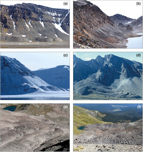
Relict TRGs are more subdued than their active counterparts due to subsidence associated with thaw of subsurface ice, but retain distinct frontal ramps and concentric transverse ridges (e and f). They are of widespread occurrence in mountainous areas that experienced permafrost development following the retreat of the last Pleistocene glaciers and ice sheets. Numerous examples have been documented, for example, in the European Alps (Colucci et al., Citation2016; Frauenfelder et al., Citation2001; Moran et al., Citation2016), Tatra Mountains (Dlabáčková et al., Citation2023) Southern Alps of New Zealand (Brazier et al., Citation1998); Japanese Alps (Aoyama, Citation2005), northern Norway (Maclean, Citation1991; Sollid & Sørbel, Citation1992), and Caucasus (Tieldidze et al., Citation2023); they occur even on the low (<700 m) mountains of SW Poland (Zurawek, Citation2002).
In an analysis of 28 putative relict ‘rock glaciers’ that had been previously identified as such in the mountains of Great Britain and Ireland, Jarman et al. (Citation2013, p. 141) concluded that ‘ … none warrants classification as a rock glacier’. They attributed their apparent absence in the British Isles to early seasonal snowcover ‘ … preventing the seeding ground for protalus rock glaciers from permafrost development’. The aims of this paper are threefold: (i) to critically review alternative explanations for the paucity of TRGs in Scotland; (ii) to re-evaluate the evidence for the presence of relict TRGs in the Cairngorm Mountains, and its implications; and (iii) to discuss possible reasons for their scarcity even at apparently suitable sites.
‘Rock glaciers’ in the British Isles
Drawing on previous interpretations of supposed ‘rock glaciers’ at several mountainous locations in the British Isles, Harrison et al. (Citation2008) identified 29 possible candidates, including 22 TRGs (‘protalus lobes’), but noted that some of these could represent rock avalanche runout debris, which sometimes mimics TRG morphology. That this is the case was demonstrated in papers that reinterpreted all but two of the eight ‘rock glaciers’ documented by Harrison et al. (Citation2008) in Scotland (those at Beinn Alligin, Baosbheinn, Beinn Shiantaidh on Jura and three sites in the Cairngorms) as rock avalanche runout deposits (Ballantyne et al., Citation2009, Citation2014b; Ballantyne & Stone, Citation2004, Citation2009). The exceptions, at Coire Beanaidh and Coire Ruadh in the Cairngorms, are discussed below. Similarly, several landforms previously interpreted as TRGs in NW Ireland were reinterpreted by Wilson (Citation2004) as rock avalanche deposits; and supposed TRGs in the English Lake District were shown by Wilson (Citation2011) to have a different origin.
Jarman et al. (Citation2013) extended this reinterpretation of proposed TRGs to conclude that all landforms in the British Isles previously interpreted as rock glaciers probably had a different origin: some as rock avalanche deposits, others as protalus ramparts, moraines, bedrock knolls with a coarse debris veneer or the products of intermittent rockfall. If this view is valid, it raises the question as to why TRGs failed to form in the British Isles under the cold stadial conditions that prevailed during the final stages of the retreat of the last British-Irish Ice Sheet (∼19.0–14.0 ka) and particularly during the Loch Lomond (≈Younger Dryas) Stade of ∼12.9–11.7 ka, when numerous TRGs of similar age developed in mountainous areas elsewhere.
The apparent absence of Lateglacial TRGs in Scotland may be attributed to one or more of three factors: geology, topography and/or Lateglacial climate. The development of TRGs requires an abundant supply of coarse rockfall debris from steep rockwalls (Kirkbride & Brazier, Citation1998) and has been shown to be particularly widespread on certain lithologies, particularly granite and other crystalline rocks (Chueca, Citation1992; Evin, Citation1987), volcanic lithologies (Humlum, Citation2000) and massive sedimentary rocks (Calkin et al., Citation1998). Active TRGs occur, however, on all rock types where glacial erosion has resulted in the formation of steep rockwalls skirted by thick talus accumulations (Burger et al., Citation1999; Kääb, Citation2013). Given the wide lithological variety of mountains in the Scottish Highlands (including granite, volcanic rocks, sandstones, and a wide range of metasedimentary rocks) it is unlikely that geology has imposed a limiting constraint on TRG formation on Scottish mountains.
Deglacial unloading of rockwalls typically results in reduction in rock-mass strength due to stress redistribution and resulting fracture propagation, accompanied by thermomechanical strain and hydromechanical fatigue (Hugentobler et al., Citation2022). As a result, enhanced rockfall and talus accumulation occurs immediately after deglaciation, particularly under periglacial conditions where annual freeze–thaw cycles contribute to rock release from cliffs. More locally, critically weakened rock slopes experience large-scale failure in the centuries or millennia following ice-sheet deglaciation. In Scotland, there is abundant evidence for both the rapid accumulation of rockfall debris to form talus accumulations during the Lateglacial period (Hinchliffe & Ballantyne, Citation1999, Citation2009) and for enhanced rock-slope failure within three millennia following ice-sheet deglaciation (Ballantyne et al., Citation2014a). It therefore appears unlikely that topography has restricted the development of TRGs, particularly as these occur in other mountain areas of lower relief (Zurawek, Citation2002). Eliminating geology and topography as limiting constraints suggests that the absence or scarcity of TRGs in the Scotland may be directly or indirectly attributable to the characteristics of Lateglacial climate.
Climate and permafrost during the Lateglacial period
The Lateglacial period in Scotland spanned the interval between ice-sheet deglaciation (∼19–14 ka, depending on location) and the end of the Loch Lomond Stade at ∼11.7 ka. It encompasses the final millennia of the Dimlington Stade, which was succeeded by a period of generally cool temperate conditions, the Lateglacial Interstade (∼14.7–12.9 ka) and a return to extremely cold conditions during the Loch Lomond Stade (LLS; ∼12.9–11.7 ka; ).
Figure 2. Subdivision of the Lateglacial period in the British Isles, showing oxygen isotope (δ18O) fluctuations in the Greenland ice core record for the 17–10 ka. Also shown are mean July temperatures inferred from subfossil chironomid assemblages in southern Scotland by Brooks and Birks (Citation2000).
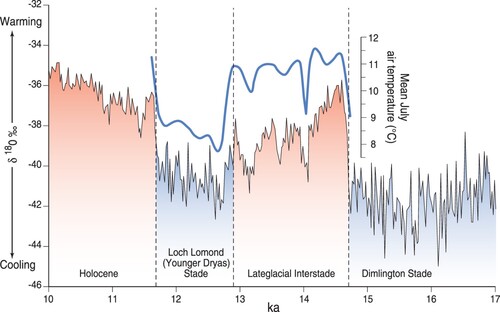
Analyses of subfossil coleopteran assemblages suggests that during the final part of the Dimlington Stade, mean annual air temperatures (MAATs) in central England lay between −5°C and −10°C prior to rapid warming at ∼14.7 ka (Atkinson et al., Citation1987), and were presumably slightly lower in Scotland. Palaeotemperature reconstructions based on subfossil chironomid assemblages in Scotland show that mean July temperatures in the early Lateglacial Interstade approached those of the present then exhibited a gradual oscillatory decline, with a rapid drop to between +7°C and +8°C near sea level during the LLS (; Brooks et al., Citation2012; Walker & Lowe, Citation2019). The coleopteran record of Atkinson et al. (Citation1987) suggests that mean January sea-level temperatures lay between −15°C and −20° at this time, implying that MAATs in Scotland fell to between −3.5°C to −6.5°C (or lower) during the coldest part of the LLS (Ballantyne, Citation2018, pp. 329–331). Regional palaeotemperature reconstructions for NW Europe imply sea-level MAATs below −8°C in Scotland at that time (Isarin, Citation1997; Schenk et al., Citation2018). The sea-level temperature regime of Scotland during the LLS therefore approximated the present temperature cycle at 78°N on Svalbard (mean July temperature +5°C, mean January temperature −16°C, MAAT −5.5°C), where continuous permafrost extends to sea level and active TRGs are common (a–c; Kääb et al., Citation2002; Sollid & Sørbel, Citation1992).
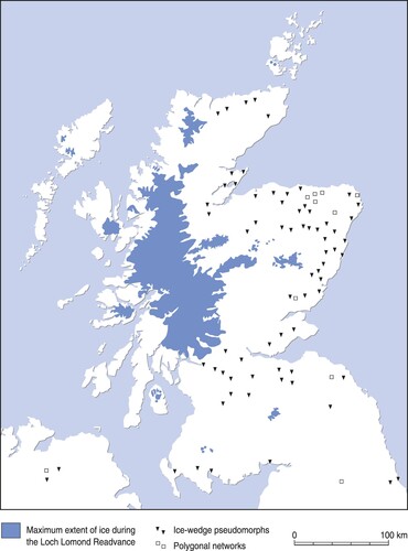
Continuous permafrost is present where MAAT is less than about −5°C to −6°C, so it is likely that it existed down to sea-level in Scotland following retreat of the last ice sheet during the final millennia of the Dimlington Stade and again during the LLS. Evidence for this takes the form of relict thermal contraction-crack polygons and ice-wedge pseudomorphs (; Ballantyne, Citation2018; Ballantyne & Harris, Citation1994; Murton & Ballantyne, Citation2017). Ice-wedge pseudomorphs (‘ice-wedge casts’) in gravels indicate former continuous permafrost and MAATs of ≤ −6°C. In Scotland, these features are undated, but development of continuous permafrost to low altitudes in England during the LLS has been demonstrated by Worsley (Citation2014) and Bateman et al. (Citation2015), who described ice-wedge pseudomorphs in LLS gravels. Analysis of cryogenic cave carbonates in England suggests that permafrost persisted there throughout the LLS (Töchterle et al., Citation2023) and the evidence provided by relict active-layer detachment failures implies localised extension of permafrost to southern England at that time (Murton & Ballantyne, Citation2017).
Figure 3. Distribution of landforms and soil structures that demonstrate Lateglacial permafrost down to sea level in Scotland, and limit of glacier ice during the Loch Lomond Stade.
The palaeotemperature and geomorphological evidence for development of permafrost down to sea level in Scotland negates the suggestion of Jarman et al. (Citation2013) that permafrost failed to develop ‘ … in the seeding grounds of rock glaciers’, particularly on high ground where Lateglacial temperatures must have been several degrees lower than those cited above. Moreover, it has long been established that permafrost develops preferentially within coarse debris at the foot of talus slopes (Kenner et al., Citation2017). Several studies have demonstrated that relatively warm air moves upslope within talus accumulations, drawing denser cold air into the lower part of the slope (e.g. Delaloye & Lambiel, Citation2005; Lambiel & Pieracci, Citation2008; Phillips et al., Citation2009; Stiegler et al., Citation2014; Wicky & Hauck, Citation2016), so that the lower parts of talus slopes (the ‘seeding ground’ of TRGs) are colder than the adjacent terrain. Such undercooling allows the maintenance of localised permafrost and continued movement of TRGs even where MAATs exceed 0°C. Active TRGs in southern Norway, for example, occur where MAAT is +1.6°C, implying a negative thermal offset of at least −3.6°C to permit preservation of permafrost within the deforming debris cover (Nesje et al., Citation2021). The apparent absence or scarcity of Lateglacial rock glaciers in the British Isles is therefore not due to absence of permafrost.
Former glaciers limited relict TRG formation
Haeberli (Citation1985) formulated a simple model to illustrate the climatic niche occupied by TRGs (). Although the details of this diagram are open to debate, the principle he outlined is not. His model shows that active TRG distribution is limited in part by the presence of permafrost, although, as discussed above, the associated MAAT may be slightly warmer than his diagram indicates. The other climatic constraint implied by the model is mean annual precipitation (MAP): as precipitation increases, it becomes increasingly likely that potential sites of TRG formation (such as cirques and below cliffs bordering glacial troughs) are occupied by glaciers. TRGs are therefore most likely to form in permafrost environments of low or moderate precipitation, where limited snowfall restricts glacier extent. Haeberli’s model, based on observations of TRG distribution in the European Alps, has been shown to be reasonably robust in other mountain areas, though Brazier et al. (Citation1998) have shown that active TRGs in the Southern Alps of New Zealand occupy a narrower climatic niche, where MAP is less than ∼1500 mm a−1. Similarly, research by Humlum (Citation1998) suggests that active TRGs rarely occur where MAP exceeds 1700 mm a−1. Humlum stressed that in permafrost environments, local topoclimatic factors may determine whether a particular site hosts glacier ice or a TRG, the former occurring ‘ … at sites with high snow accumulation in relation to the input of talus … ’ and the latter being located ‘ … at sites with low snow accumulation in relation to talus input’ (p. 390).
Figure 4. Haeberli’s (Citation1985) model of climatic constraints on talus rock glacier formation. Although approximate, it illustrates the requirement for permafrost and how TRGs are unlikely to form at sites where high precipitation (snowfall) favours the development of glacier ice.
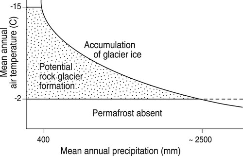
Patterns of precipitation across the Scottish Highlands during the LLS have been reconstructed from the equilibrium line altitudes (ELAs) of coeval glaciers. A marked west–east increase in ELAs, from ∼200 m on the Outer Hebrides to ∼920 m in the Cairngorms, has been interpreted by Sissons (Citation1979a) and Chandler et al. (Citation2019) in terms of a steep eastwards decline in stadial precipitation, due to the passage of dominantly westerly airmasses and ‘scavenging’ of snowfall by the extensive icefield that occupied much of the western Highlands at that time (). Calculations based on reconstructed ELAs suggest that LLS precipitation exceeded 1700 mm a−1 across western Scotland from Arran to the Outer Hebrides but fell to below 1000 mm a−1 east of the West Highland Icefield, and to as little as 543 ± 278 mm a−1 in the Cairngorms (Chandler et al., Citation2019). In consequence, whereas most corries and glacial troughs in the western Highlands were occupied by glaciers during the LLS, those east of the icefield supported only plateau ice caps, small icefields or, in the Cairngorms, isolated cirque and valley glaciers (Bickerdike et al., Citation2016; Sissons, Citation1979b; Standell, Citation2014). It follows that if relict TRGs of LLS age are present in Scotland, they are most likely to occur in the Eastern Grampian Highlands, and particularly in the Cairngorms, where some corries and troughs remained glacier-free under the relatively arid conditions that pertained there during the LLS. The apparent absence of TRGs elsewhere in the Scottish Highlands during the LLS is therefore at least partly explicable in terms of glacier ice invading most potential sites of TRG formation.
Talus rock glaciers in the northern corries of Braeriach, western Cairngorm Mountains
Sandeman and Ballantyne (Citation1996) identified four putative TRGs in the Cairngorms, but Ballantyne et al. (Citation2009) subsequently reinterpreted three of these as runout debris associated with rock-slope failures. Of the fourth, in Coire Beanaidh, they noted (p. 27) that ‘ … the surface morphology of the Coire Beanaidh [debris] accumulation is much more consistent with a rock-glacier interpretation than any of the other three sites investigated … ’ and that ‘a rock glacier origin therefore cannot be discounted on morphological grounds alone’.
The northern slopes of Braeriach (1296 m) in the western Cairngorms are occupied by three corries (cirques): Coire an Lochain in the west, Coire Ruadh in the centre and Coire Beanaidh in the east. During the LLS, Coire an Lochain was occupied by a small cirque glacier that terminated at an arcuate end moraine (; Sissons, Citation1979b; Standell, Citation2014), but there is no evidence that glaciers occupied Coire Ruadh and Coire Beanaidh at that time, implying that both were underlain by permafrost and exposed to severe periglacial conditions throughout the LLS.
Figure 5. Vertical satellite image (Google EarthTM) of the northern corries of Braeriach, showing the location of the three landforms here interpreted as talus rock glaciers. The location of the Loch Lomond Stadial terminal moraine in Coire an Lochain is also shown. Coire Ruadh and Coire Beanaidh lack evidence of reoccupation by glacier ice during the Loch Lomond Stade.
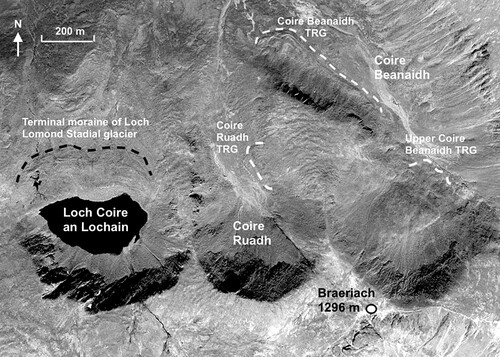
The Coire Beanaidh talus rock glacier [57.0898°N, 3.7308°W; NH 953012]
The remarkable debris accumulation at the foot of a NE-facing rockwall and talus slope at Coire Beanaidh in the western Cairngorms was first identified as a TRG by Sissons (Citation1979b), surveyed by Chattopadhyay (Citation1984) and Maclean (Citation1991), and described by Sandeman and Ballantyne (Citation1996). It comprises two morphological elements: a bouldery talus-foot bench or terrace, 450 m long, that broadens to the NW, where it merges with a debris lobe, 210 m long and 240 m wide (across-slope), aligned obliquely to the parent talus slope (). The lobe consists of an arcuate terminal boulder ridge within which are two or three nested convex-outward boulder ridges separated by boulder-filled depressions up to 5 m deep. The entire landform has a perimeter length of 805 m and descends along the margin of the corrie floor from 930 m to 840 m. It is defined by a boulder ramp, 8–12 m high, that rises abruptly from the adjacent corrie floor at 20–26°. The surface of the deposit is composed of openwork boulders, typically 0.2–1.0 m in length. The overall volume of the feature, assessed from surveyed transects, is ∼234,000 m3 (Sandeman & Ballantyne, Citation1996), implying that it contains ∼168,000 m3 of rock. Cosmogenic 10Be exposure dating of samples chiselled from boulders on ridges within the lobe produced an uncertainty-weighted mean age of 12.7 ± 0.8 ka (Ballantyne et al., Citation2009), confirming that the lobe formed during under the permafrost conditions of the LLS.
Figure 6. The Coire Beanaidh relict talus rock glacier. (a) Oblique satellite image showing how the steep-fronted debris bench to the SE (left) broadens to the NW, forming a distinct lobe containing two to four nested debris ridges (Google EarthTM image). (b) Photograph of the rock glacier from the opposite side of Coire Beanaidh. (c) View SE along the debris bench. (d) The terminal ridge at the NW end of the lobate section.
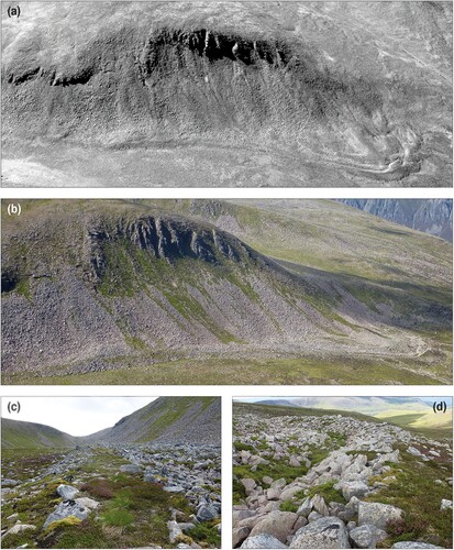
The Coire Beanaidh feature () has all the morphological hallmarks of a relict TRG: an abrupt outer margin, bench-like and lobate planform, and nested transverse ridges, parallel or sub-parallel to the outermost ridge. As with relict TRGs in other mountainous environments (e and f), melt-out of subsurface ice has lowered the gradients of the outer ramp and the nested interior ridges and produced shallow enclosed depressions on surface of the lobe. Acceptance of this interpretation, however, requires exclusion of all other possible origins. Jarman et al. (Citation2013, pp. 137–139) considered the landform to have ‘ … evolved polygenetically as a thin glacier interacted with slope-derived debris … ’ to form ‘ … an ice-marginal protalus bank’. This proposal invokes the presence of a (glaciologically impossible) ‘thin glacier’ (for which there is no evidence) in Coire Beanaidh and fails to account for the development of a broad lobe of debris and nested ridges that curve upslope away from the valley axis. The debris accumulation cannot represent a protalus rampart formed by rockfall debris accumulating at the foot of a perennial firn field. The debris lobe extends nearly 200 m obliquely from the talus foot, whereas protalus ramparts form directly below the source rockwall by gravitational accumulation of debris. Moreover, modelling of the threshold conditions under which talus-foot firn fields remain stationary has shown that the maximum distance between a protalus rampart crest and the talus foot cannot exceed 30–70 m (depending on the firn gradient); at greater distances internal deformation within the firn field transforms it into a small glacier (Ballantyne & Benn, Citation1994). Conversely, the feature cannot represent end and recessional moraines, as the bench-like upper part lies too close to the talus foot to permit glacier formation, and all other LLS cirque glaciers in the Cairngorms have developed in cirque-head locations (as in Coire an Lochain; ). Finally, an alternative explanation of the landform assemblage as the runout debris of a catastrophic rock-slope failure (RSF) can be discounted as: (i) there is no rockwall source cavity; (ii) RSF runout cannot account for the 450 m long bench at the foot of the talus slope; (iii) the lobate section of the landform is not located at the foot of the rockwall, as would be expected of RSF runout debris, but displaced farther downslope to the northwest and (iv) there is an absence of very large boulders, which are present on other RSF runout deposits in the Cairngorms (Ballantyne et al., Citation2009); few boulders on the debris lobe or bench exceed 1.0 m in length, consistent with the calibre of boulders on the parent talus slope. It remains possible, however, that small rockslides contributed some of the debris that fed the development of the landform. Given its location, age and morphology, the Coire Beanaidh landform fulfils all the criteria for identifying a relict Lateglacial TRG; no other viable interpretation can account for all of its characteristics.
The upper Coire Beanaidh talus rock glacier [57.0845°N, 3.7212°W; NH 955006]
Sissons (Citation1979b) mapped another TRG on the NE-facing slope near the head of Coire Beanaidh at ∼950–975 m altitude (). Here the lower parts of the debris slope form four overlapping crescentic boulder ridges or benches, the outermost of which rises up to 7 m above the adjacent ground (). Although this feature lacks some of the diagnostic features of a mature TRG, it appears to represent downslope deformation of the debris mantle and is here interpreted as an incipient TRG. If this interpretation is valid, it suggests that similar landforms elsewhere, hitherto disregarded in the search for ‘classic’ talus rock glaciers, may be interpreted as indicative of limited deformation of ice or ice-rich permafrozen sediments under a cover of coarse debris.
Figure 7. Oblique satellite image of overlapping arcuate ramps or ridges of bouldery debris (arrowed) in upper Coire Beanaidh, viewed from the northeast. These have apparently formed though downslope deformation of subsurface ice or ice-supersaturated sediment and are interpreted as representing an incipient rock glacier (Google EarthTM image).
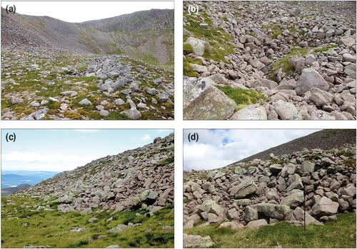
The Coire Ruadh talus rock glacier [57.0853°N, 3.7332°W; NH 951005]
At the foot of the west-facing slope of Coire Ruadh () is a well-defined bench or terrace of bouldery debris, bounded by a steep (20–32°) ramp up to 10 m high that culminates in a low terminal ridge (). The boulder bench is 190 m long and extends 50–70 m from the base of the adjacent slope, has a planimetric area of ∼12,700 m2 and is enclosed by an outer perimeter 290 m long. It descends gradually northwards (downslope) from 1020 m to 980 m, supports three weakly-defined arcuate boulder ridges parallel to the terminal ridge near its northern end, and is pitted with enclosed pits up to 4.5 m deep (b). As with the Coire Beanaidh TRG, it is entirely composed of openwork bouldery debris, apart from superficial sandy soil on the boulder bench. Collectively, the characteristics of this landform suggest that it is a relict TRG, similar to its neighbour in Coire Beanaidh, as proposed by Sissons (Citation1979b). It differs from the Coire Beanaidh TRG in that there is no exposed rockwall on this side of the corrie; the boulder bench appears to have formed through deformation of the adjacent debris-mantled slope rather than rockfall talus. It is therefore analogous to relict blockslope-derived rock glaciers elsewhere, with which it shares common characteristics (Gordon & Ballantyne, Citation2006; Hu et al., Citation2021).
Figure 8. The Coire Ruadh relict rock glacier. (a) Surface of the rock glacier, looking SE towards the head of Coire Ruadh. (b) Collapse pit, 4.5 m deep, inferred to have been produced by melt of subsurface ice. (c) SW-facing frontal ramp of the rock glacier, ∼10 m high. (d) Detail of boulders in the frontal ramp. The pole is one metre long.
Jarman et al. (Citation2013, p. 137) proposed that the Coire Ruadh landform represents another example of an ‘ice-marginal protalus bank’ that ‘evolved along a talus-cirque glacier interface’ and illustrated how it might have formed at the margin of an (impossibly thin) glacier. They nevertheless conceded that it could be ‘a possible rock glacier candidate’. Given that there is no evidence for glacier occupance of Coire Ruadh during the LLS and that the planform of this feature (which curves in towards the slope at its downvalley end) is impossible to reconcile with accumulation of debris at a glacier margin, the notion that it represents an ‘ice-marginal protalus bank’ is unsustainable. The landform cannot represent a protalus rampart or RSF runout debris as there is no source rockwall. Given the absence of plausible alternatives, Sissons’ (Citation1979b ) original interpretation of the Coire Ruadh boulder bench as a TRG (resembling those in b and c) appears correct.
Discussion
TRG formation requires not only the establishment of permafrost, but also the development of massive ground ice or ice-supersaturated sediment under and within debris to an overall depth sufficient to permit deformation (steady-state creep) to occur. The high ice content of active TRGs (40–70% by volume) suggests that movement may be approximated by creep of ice under moderate driving stress (Burger et al., Citation1999; Haeberli et al., Citation2006; Kenner et al., Citation2021), according to the flow law:
(1)
(1) where dϵ / dt is strain rate, β is a temperature-dependent constant, n is an exponent that lies between 1.9 and 4.2 (Arenson & Springman, Citation2005; n = 3 is often assumed for pure ice) and τ is driving stress (shear stress), given by:
(2)
(2) where ρ and z are, respectively, the mean density and thickness of the debris mantle and underlying ice-rich core, g is gravitational acceleration (∼9.8 m s−2), and α is mean surface gradient. The driving stress is thus linearly related to the total thickness and mean density of the debris mantle and ice-rich core; as the strain rate increases nonlinearly with increased driving stress, both parameters (together with permafrost temperature) strongly affect the strain rate.
For a sample of active ‘alpine’ TRGs where the permafrost temperature is close to 0°C, Cicoira et al. (Citation2021) found that thickness in metres (z) could be approximated by a linear relationship with slope angle (α):
(3)
(3) and by rearranging the terms of Equation (2) and adding an empirical uncertainty by:
(4)
(4) For both expressions, shows the values of z for α = 15°, 20°, 25°, 30° and 35°. Mean density (ρ) was calculated for volumetric ice contents of 40–70% based on assumption of an ice density of 900 kg m−3 and 2500 kg m−3 for rock debris, with all voids being ice-filled. Cicoira et al. (Citation2021) found that the mean driving stress (τ) associated with their sample of TRGs is 92 kPa and this value is used in estimating TRG thickness from Equation (4). This figure, however, was derived for ‘alpine’ TRGs where permafrost temperatures are close to 0°C, unfrozen water is abundant and most deformation occurs within a narrow shear zone that underlies the ice-rich core. Because the deformation rate of ice-rich permafrost declines approximately exponentially as the temperature falls below 0°C (Huang et al., Citation1986) and a shear zone develops only after initial deformation of the ice-rich core (Cicoira et al., Citation2021), the driving stress (and hence debris-ice thickness) required to initiate TRG development in areas of ‘cold’ (< −3°C) permafrost is likely to be considerably greater. For example, an assumption of τ = 150 kPa and 50% ice content yields a critical debris-ice thickness of 18.0 ± 3.4 m for α = 30° and 26.3 ± 3.4 m for α = 20°. This contrast partly explains why many ‘arctic’ TRGs (a–c) tend to have a bench-like planform and extend only a short distance from talus footslopes, whereas faster-moving ‘alpine’ TRGs (d) often form lobate landforms that extend hundreds of metres from the parent talus accumulation. As continuous permafrost extended down to sea level in Scotland during the LLS, that on high ground where MAATs were several degrees lower was almost certainly ‘cold’ permafrost that favoured the development of ‘arctic’-type TRGs. It follows that the figures for TRG thickness (z) in must be regarded as minima; actual threshold thickness is likely to have been greater.
Table 1. Empirically-derived estimates of talus rock glacier thickness.
Both models suggest that TRG initiation is possible on steep (30–35°) talus footslopes where the overall thickness of the debris-ice mix is ≥10 m. However, taluses formed by discrete rockfall events consist of an upper rectilinear slope at 33–38°, and a basal concavity that steepens upslope from level ground (Francou & Manté, Citation1990; Kirkby & Statham, Citation1975). Moreover, the proportion of the slope occupied by the basal concavity is accentuated by downslope debris transfer by debris flows and particularly snow avalanches (e.g. Luckman, Citation1977), so the average gradient of the footslope ‘seeding ground’ of TRGs is often <30°, implying that the critical thickness for TRG initiation may be greater. Modelling of hypothetical thresholds (Kirkbride & Brazier, Citation1995) suggests that even under sustained cold conditions, different talus slopes (or different parts of the same talus slope) may respond in different ways, depending on talus thickness and the rate of rockfall accumulation: some may evolve as ‘multi-lobe’ TRGs, some as single lobes or debris benches, and others may not deform at all even if ground ice is present because the critical thickness of the debris-ice mix is not achieved.
The above considerations have two implications. First, they suggest that TRG development even in the Cairngorms may have been limited not by the absence of permafrost, but because the permafrost temperature was several degrees below 0°C, which in turn increased the threshold thickness of the debris mantle and underlying ice-rich zone so that TRGs developed only at exceptionally favourable locations. Second, they suggest that where TRGs have developed, as in Coire Beanaidh and Coire Ruadh, they are most likely to have a bench-like planform, similar to that of active ‘arctic’ TRGs (a–c).
It is possible that the relict TRGs described above therefore represent different stages in TRG evolution: the incipient TRG in upper Coire Beanaidh () appears to represent limited, gradual deformation of underlying ice or ice-rich sediment on a steep (25–30°) slope; the bench-like form of the Coire Ruadh TRG and the upper part of the Coire Beanaidh TRG represent more advanced deformation, analogous to that shown for active arctic TRGs in a–c; and the Coire Beanaidh TRG lobe represents an unusual and possibly unique (in Scotland) TRG where the driving stress and resultant strain rate were sufficient to promote the development of a multi-ridged lobate TRG, similar to that in d. A speculative explanation for this apparently unique landform is that lobe development occurred as permafrost temperature increased at the end of the LLS, permitting accelerated movement.
Because a considerable thickness of coarse debris and ground ice is required to develop before deformation occurs (), there is a time lag between the onset of permafrost development and TRG initiation (Kirkbride & Brazier, Citation1995; Morris & Olyphant, Citation1990; Whalley & Martin, Citation1992). All three examples described above occur at high altitudes (>840 m OD), suggesting that these areas experienced early development of permafrost and hence were most likely to favour the development of a sufficient depth of ice or ice-supersaturated sediment to initiate movement, but only where the debris accumulation was sufficiently thick. A number of other high-level sites in the Cairngorms provide evidence of deformation of talus or blockslope debris. One example is that identified by Humlum (in Jarman et al., Citation2013) in Coire Bogha-cloiche, a corrie west of Braeriach [57.0774°N, 3.7683°W; NN 930999] that remained glacier-free during the LLS. Below the south-facing cliffs in this corrie is a talus-foot boulder bench, ∼710 m long (downslope) and up to 140 m wide, that descends westwards from 910 m to 800 m. Like the Coire Beanaidh and Coire Ruadh TRGs, this landform is bounded by a steep distal ramp and terminal boulder ridge, has an undulating surface and contains enclosed pits consistent with subsidence due to melt-out of subsurface ice. Elsewhere in the Cairngorms are a few high-level (>800 m) sites where the lower parts of talus slopes or blockslopes form convex-downslope arcuate ramps or ridges, similar to those depicted in , but these await field evaluation.
Conclusion
Most landforms previously identified as relict TRGs in the Scottish Highlands have been reinterpreted as rock-avalanche runout debris (Ballantyne & Stone, Citation2004, Citation2009; Ballantyne et al., Citation2009, Citation2014b), and Jarman et al. (Citation2013) have concluded that none of the landforms formerly identified as ‘rock glaciers’ in the British Isles warrant classification as such. The apparent absence or scarcity of relict Lateglacial TRGs in the mountains of Scotland and elsewhere in the British Isles cannot be explained by the absence of permafrost. For Scotland, a more plausible explanation is that most potential sites of TRG formation were occupied by glaciers during the LLS. The relative aridity of the Cairngorm Mountains at this time, however, favoured localised development of TRGs in high-level corries that remained glacier-free.
The three TRGs described above are interpreted as being representative of different stages of development, ranging from an incipient or immature TRG formed by the deformation of bouldery debris in upper Coire Beanaidh, a bench-like TRG farther downvalley, a similar blockslope-sourced rock glacier in Coire Ruadh, and a TRG lobe with nested transverse ridges in lower Coire Beanaidh. All of these sites have characteristics consistent with movement of bouldery debris through deformation of an ice-rich core, and cannot be explained as protalus ramparts, rock avalanche runout deposits or ice-marginal debris accumulations. Similar features occur at a few other high-level sites in the Cairngorms, but most talus slopes outside the limits of LLS glaciers have not experienced deformation, probably because the driving stresses engendered in the frozen talus were insufficient to initiate TRG formation.
Finally, it is notable that accounts of supposed ‘rock glaciers’ in the British Isles have focused on substantial lobate or lingulate boulder accumulations, rather than bench-like boulder features or small arcuate ramps or ridges at or near the foot of talus slopes or blockslopes. Widening the search for relict rock glaciers to similar features in other areas where cirques and glacial troughs remained unoccupied by glaciers during the LLS, such as the mountains of Wales and Ireland, may reveal that they are not restricted to the Cairngorms.
Acknowledgements
I thank Stephan Harrison for stimulating re-evaluation of the apparently anomalous absence of Lateglacial rock glaciers in the mountains of the British Isles, Graeme Sandeman for preparing the figures and four anonymous reviewers and the Associate Editor, Dr Martin Hurst, for their helpful comments on the original manuscript.
Disclosure statement
No potential conflict of interest was reported by the author(s).
References
- Aoyama, M. (2005). Rock glaciers in the northern Japanese Alps: palaeoenvironmental implications since the Late Glacial. Journal of Quaternary Science, 20(5), 471–484. https://doi.org/10.1002/jqs.935
- Arenson, L. U., & Springman, S. (2005). Mathematical descriptions for the behaviour of ice-rich frozen soils at temperatures close to 0°C. Canadian Geotechnical Journal, 42(2), 431–442. https://doi.org/10.1139/t04-109
- Atkinson, T. C., Briffa, K. R., & Coope, G. R. (1987). Seasonal temperatures in Britain during the past 22,000 years, reconstructed using beetle remains. Nature, 325(6105), 587–592. https://doi.org/10.1038/325587a0
- Ballantyne, C. K. (2018). Periglacial geomorphology. Wiley-Blackwell. 454 pp.
- Ballantyne, C. K., & Benn, D. I. (1994). Glaciological constraints on protalus rampart development. Permafrost and Periglacial Processes, 5(3), 145–153. https://doi.org/10.1002/ppp.3430050304
- Ballantyne, C. K., & Harris, C. (1994). The periglaciation of Great Britain. Cambridge University Press. 330 pp.
- Ballantyne, C. K., Sandeman, G. F., Stone, J. O., & Wilson, P. (2014a). Rock-slope failure following Late Pleistocene deglaciation on tectonically stable mountainous terrain. Quaternary Science Reviews, 86, 144–157. https://doi.org/10.1016/j.quascirev.2013.12.021
- Ballantyne, C. K., Schnabel, C., & Xu, S. (2009). Exposure dating and reinterpretation of coarse debris accumulations (‘rock glaciers’) in the Cairngorm Mountains, Scotland. Journal of Quaternary Science, 24(1), 19–31. https://doi.org/10.1002/jqs.1189
- Ballantyne, C. K., & Stone, J. O. (2004). The Beinn Alligin rock avalanche, NW Scotland: Cosmogenic 10Be dating, interpretation and significance. The Holocene, 14(3), 448–453. https://doi.org/10.1191/0959683604hl720rr
- Ballantyne, C. K., & Stone, J. O. (2009). Rock-slope failure at Baosbheinn, Wester Ross, NW Scotland: Age and interpretation. Scottish Journal of Geology, 45(2), 177–181. https://doi.org/10.1144/0036-9276/01-388
- Ballantyne, C. K., Wilson, P., Gheorghiu, D., & Rodés, À. (2014b). Enhanced rock-slope failure following ice-sheet deglaciation: Timing and causes. Earth Surface Processes and Landforms, 39(7), 900–913. https://doi.org/10.1002/esp.3495
- Barsch, D. (1996). Rockglaciers: Indicators for the present and former geoecology in high mountain environments. Springer-Verlag. 212 pp.
- Bateman, M. D., Evans, D. J. A., Buckland, P. C., Connell, E. R., Friend, R. J., Hartmann, D., Moxon, H., Fairburn, W. A., Panagiotakopulu, E., & Ashurst, R. A. (2015). Last glacial dynamics of the Vale of York and North Sea lobes of the British and Irish Ice Sheet. Proceedings of the Geologists’ Association, 126(6), 712–730. https://doi.org/10.1016/j.pgeola.2015.09.005
- Berthling, I. (2011). Beyond confusion: Rock glaciers as cryo-conditioned landforms. Geomorphology, 131(3-4), 98–106. https://doi.org/10.1016/j.geomorph.2011.05.002
- Bickerdike, H. L., Evans, D. J. A., Cofaigh, Ó., & Stokes, C. R. (2016). The glacial geomorphology of the Loch Lomond Stadial in Britain: A map and geographic information system resource of published evidence. Journal of Maps, 12(5), 1178–1186. https://doi.org/10.1080/17445647.2016.1145149
- Bollman, E., Girstymair, A., Mitterer, S., Krainer, K., Sailer, R., & Stötter, J. (2015). A rock glacier activity index based on rock glacier thickness changes and displacement rates derived from airborne laser scanning. Permafrost and Periglacial Processes, 26(4), 347–359. https://doi.org/10.1002/ppp.1852
- Brazier, V., Kirkbride, M. P., & Owens, I. F. (1998). The relationship between climate and rock glacier distribution in the Ben Ohau Range, New Zealand. Geografiska Annaler: Series A, Physical Geography, 80(3-4), 193–207. https://doi.org/10.1111/j.0435-3676.1998.00037.x
- Brooks, S. J., & Birks, H. J. B. (2000). Chironomid-inferred late-glacial air temperatures at Whitrig Bog, south-east Scotland. Journal of Quaternary Science, 15(8), 759–764. https://doi.org/10.1002/1099-1417(200012)15:8<759::AID-JQS590>3.0.CO;2-V
- Brooks, S. J., Matthews, I. P., Birks, H. H., & Birks, H. J. B. (2012). High resolution Lateglacial and early-Holocene summer air temperature records from Scotland inferred from chironomid assemblages. Quaternary Science Reviews, 41, 67–82. https://doi.org/10.1016/j.quascirev.2012.03.007
- Burger, K. C., Degenhardt, J. J., & Giardino, J. R. (1999). Engineering geomorphology of rock glaciers. Geomorphology, 31(1-4), 93–132. https://doi.org/10.1016/S0169-555X(99)00074-4
- Calkin, P. E., Haworth, L. A., & Ellis, J. M. (1998). Rock glaciers of central Brooks Range, Alaska. In J. R. Giardino, J. F. Schroder, & J. D. Vitek (Eds.), Rock glaciers (pp. 65–82). Allen & Unwin.
- Chandler, B. M. P., Boston, C. M., & Lukas, S. (2019). A spatially-restricted Younger Dryas plateau icefield in the Gaick, Scotland: Reconstruction and palaeoclimatic implications. Quaternary Science Reviews, 211, 107–135. https://doi.org/10.1016/j.quascirev.2019.03.019
- Chattopadhyay, G. P. (1984). A fossil valley-wall rock glacier in the Cairngorm Mountains. Scottish Journal of Geology, 20(1), 121–125. https://doi.org/10.1144/sjg20010121
- Chueca, L. (1992). A statistical analysis of the distribution of rock glaciers, Spanish central Pyrenees. Permafrost and Periglacial Processes, 3(3), 261–265. https://doi.org/10.1002/ppp.3430030316
- Cicoira, A., Marcer, M., Gärtner-Roer, I., Bodin, X., Arenson, L. U., & Vieli, A. (2021). A general theory of rock glacier creep based on in-situ and remote sensing observations. Permafrost and Periglacial Processes, 32(1), 139–153. https://doi.org/10.1002/ppp.2090
- Clark, D. H., Steig, E. J., Potter, N., & Gillespie, A. R. (1998). Genetic variability of rock glaciers. Geografiska Annaler: Series A, Physical Geography, 80(3-4), 175–182. https://doi.org/10.1111/j.0435-3676.1998.00035.x
- Colucci, R. R., Boccali, C., Zebre, M., & Guglielmin, M. (2016). Rock glaciers, protalus ramparts and pronival ramparts in the south-eastern Alps. Geomorphology, 269, 112–121. https://doi.org/10.1016/j.geomorph.2016.06.039
- Delaloye, R., & Lambiel, C. (2005). Evidence of winter ascending air circulation throughout talus slopes and rock glaciers situated in the lower belt of alpine discontinuous permafrost (Swiss Alps). Norsk Geografisk Tidsskrift - Norwegian Journal of Geography, 59, 194–203. https://doi.org/10.1080/00291950510020673
- Dlabáčková, T., Engel, Z., Uxa, T., Braucher, R., & Aster, Team. (2023). 10Be exposure ages and paleoenvironmental significance of rock glaciers in the Western Tatra Mts., Western Carpathians. Quaternary Science Reviews, 312, 108147. https://doi.org/10.1016/j.quascirev.2023.108147
- Evin, M. (1987). Lithology and fracturing control of rock glaciers in south-western Alps of France and Italy. In J. R. Giardino, J. F. Schroder, & J. D. Vitek (Eds.), Rock glaciers (pp. 83–106). Allen & Unwin.
- Francou, B., & Manté, C. (1990). Analysis of the segmentation in the profile of alpine talus slopes. Permafrost and Periglacial Processes, 1(1), 53–60. https://doi.org/10.1002/ppp.3430010107
- Frauenfelder, R., Haeberli, W., Hoelzle, M., & Maisch, M. (2001). Using relict rockglaciers in GIS-based modelling to reconstruct Younger Dryas permafrost distribution patterns in the Err-Julier area, Swiss Alp. Norsk Geografisk Tidsskrift - Norwegian Journal of Geography, 55(4), 195–202. https://doi.org/10.1080/00291950152746522
- Freher, M., Ling, A. H. M., & Gärtner-Roer, I. (2015). Furrow-and-ridge morphology on rockglaciers explained by gravity-driven buckle folding: A case study from the Murtèl Rockglacier (Switzerland). Permafrost and Periglacial Processes, 26(1), 57–66. https://doi.org/10.1002/ppp.1831
- Gordon, L. S., & Ballantyne, C. K. (2006). ‘Protalus ramparts’ on Navajo Mountain, Utah, USA: Reinterpretation as blockslope-sourced rock glaciers. Permafrost and Periglacial Processes, 17(2), 179–187. https://doi.org/10.1002/ppp.545
- Haeberli, W. (1985). Creep of mountain permafrost: Internal structure and flow of alpine rock glaciers. Mitteilungen der Versuchanstalt für Wasserbau, Hydrologie und Glaziologie, 77, 142 pp.
- Haeberli, W., Hallet, B., Arenson, L., Elconin, R., Humlum, O., Kääb, A., Kaufmann, V., Ladanyi, B., Matsuoka, N., Springman, S., & Mühll, D. V. (2006). Permafrost creep and rock glacier dynamics. Permafrost and Periglacial Processes, 17(3), 189–214. https://doi.org/10.1002/ppp.561
- Haeberli, W., & Vonder Mühll, D. (1996). On the characteristics and possible origin of ice in rock glacier permafrost. Zeitschrift für Geomorphologie Supplementband, 104, 43–57.
- Harrison, S., Whalley, W. B., & Anderson, E. (2008). Relict rock glaciers and protalus lobes in the British Isles: implications for Late Pleistocene mountain geomorphology and palaeoclimate. Journal of Quaternary Science, 23(3), 287–304. https://doi.org/10.1002/jqs.1148
- Hausmann, H., Krainer, K., Brückl, E., & Ullrich, C. (2012). Internal structure, ice content and dynamics of Ölgrube and Kaiserberg rock glaciers (Öztal Alps, Austria) determined from geophysical surveys. Austrian Journal of Earth Sciences, 102, 12–31.
- Hinchliffe, S., & Ballantyne, C. K. (1999). Talus accumulation and rockwall retreat, Trotternish, Isle of Skye, Scotland. Scottish Geographical Journal, 115(1), 53–70. https://doi.org/10.1080/00369229918737057
- Hinchliffe, S., & Ballantyne, C. K. (2009). Talus structure and evolution on sandstone mountains in NW Scotland. The Holocene, 19(3), 477–486. https://doi.org/10.1177/0959683608101396
- Hu, Y., Liu, L., Wang, X., Zhao, L., Wu, T., Cai, J., Zhu, X., & Hao, J. (2021). Quantification of permafrost creep provides kinematic evidence for classifying a puzzling periglacial landform. Earth Surface Processes and Landforms, 46(2), 465–477. https://doi.org/10.1002/esp.5039
- Huang, S. L., Aughenbach, N. B., & Wu, M.-C. (1986). Stability study of the CRREL permafrost tunnel. Journal of Geotechnical Engineering, 112(8), 777–790. https://doi.org/10.1061/(ASCE)0733-9410(1986)112:8(777)
- Hugentobler, M., Aaron, J., Loew, S., & Roques, C. (2022). Hydro-mechanical interactions within a rock slope with a retreating valley glacier. Journal of Geophysical Research: Earth Surface, 127(4), 251–260. https://doi.org/10.1029/2021JF006484
- Humlum, O. (1998). The climatic significance of rock glaciers. Permafrost and Periglacial Processes, 9(4), 375–395. https://doi.org/10.1002/(SICI)1099-1530(199810/12)9:4<375::AID-PPP301>3.0.CO;2-0
- Humlum, O. (2000). The geomorphic significance of rock glaciers: Estimates of rock glacier debris volumes and headwall recession rates in West Greenland. Geomorphology, 35(1-2), 41–67. https://doi.org/10.1016/S0169-555X(00)00022-2
- Humlum, O., Christiansen, H. H., & Juliussen, H. (2007). Avalanche-derived rock glaciers in Svalbard. Permafrost and Periglacial Processes, 18(1), 75–88. https://doi.org/10.1002/ppp.580
- Isarin, R. F. B. (1997). Permafrost distribution and temperatures in Europe during the Younger Dryas. Permafrost and Periglacial Processes, 8(3), 313–333. https://doi.org/10.1002/(SICI)1099-1530(199709)8:3<313::AID-PPP255>3.0.CO;2-E
- Jarman, D., Wilson, P., & Harrison, S. (2013). Are there any relict rock glaciers in the British mountains? Journal of Quaternary Science, 28(2), 131–143. https://doi.org/10.1002/jqs.2574
- Kääb, A. (2013). Rock glaciers and protalus forms. In S. Elias (Ed.), Encyclopedia of Quaternary Science (2nd ed., pp. 535–541). Elsevier.
- Kääb, A., Isaksen, K., Eiken, T., & Farbrot, H. (2002). Geometry and dynamics of two lobe-shaped rock glaciers in the permafrost of Svalbard. Norsk Geografisk Tidsskrift - Norwegian Journal of Geography, 56, 152–160. https://doi.org/10.1080/002919502760056486
- Kenner, R., Arenson, L. U., & Grämiger, L. (2021). Mass movement processes related to permafrost and glaciation. In J. J. F. Shroder (Ed.), Treatise on geomorphology (2nd ed., Vol. 5, pp. 283–303). Elsevier. https://doi.org/10.1016/B978-0-12-818234-5.00112-7
- Kenner, R., Phillips, M., Hauck, C., Hilbich, C., Mulsow, C., Bühler, Y., Stoffel, A., & Buchroithner, M. (2017). New insights on permafrost genesis and conservation in talus slopes based on observations at Flüelapass, Eastern Switzerland. Geomorphology, 290, 101–113. https://doi.org/10.1016/j.geomorph.2017.04.011
- Kirkbride, M. P., & Brazier, V. (1995). On the sensitivity of Holocene talus-derived rock glaciers to climate change in the Ben Ohau Range, New Zealand. Journal of Quaternary Science, 10(4), 353–365. https://doi.org/10.1002/jqs.3390100405
- Kirkby, M., & Statham, I. (1975). Surface stone movement and scree formation. The Journal of Geology, 83(3), 349–362. https://doi.org/10.1086/628097
- Lambiel, C., & Pieracci, K. (2008). Permafrost distribution in talus slopes located within the alpine periglacial belt, Swiss Alps. Permafrost and Periglacial Processes, 19(3), 293–304. https://doi.org/10.1002/ppp.624
- Leopold, M., Williams, M. W., Caine, N., Völkel, J., & Dethier, D. (2011). Internal structure of the Green Lake 5 rock glacier, Colorado Front Range, USA. Permafrost and Periglacial Processes, 22(2), 107–119. https://doi.org/10.1002/ppp.706
- Luckman, B. H. (1977). The geomorphic activity of snow avalanches. Geografiska Annaler: Series A, Physical Geography, 59(1-2), 31–48. https://doi.org/10.1080/04353676.1977.11879945
- Maclean, A. F.. (1991). The formation of valley-wall rock glaciers [PhD thesis]. University of St Andrews. http://hdl.handl.net/10023/2797
- Moran, A. P., Ivy Ochs, S., Vockenhuber, C., & Kerschner, H. (2016). Rock glacier development in the Northern Calcareous Alps at the Pleistocene-Holocene boundary. Geomorphology, 273, 178–188. https://doi.org/10.1016/j.geomorph.2016.08.017
- Morris, S. E., & Olyphant, G. A. (1990). Alpine lithofacies variation: Working toward a physically-based model. Geomorphology, 3(1), 73–90. https://doi.org/10.1016/0169-555X(90)90033-M
- Murton, J., & Ballantyne, C. K. (2017). Periglacial and permafrost ground models for Great Britain. Geological Society, London, Engineering Geology Special Publications, 28(1), 501–597. https://doi.org/10.1144/EGSP28.5
- Nesje, A., Matthews, J. A., Linge, H., Bredal, M., Wilson, P., & Winkler, S. (2021). New evidence for active talus-foot rock glaciers at Øyberget, southern Norway, and their development during the Holocene. The Holocene, 31(11-12), 1786–1796. https://doi.org/10.1177/09596836211033226
- Phillips, M., Mutter, E. K., Kern-Luetschg, M., & Lehning, M. (2009). Rapid degradation of ground ice in a ventilated talus slope: Flüela pass, Swiss Alps. Permafrost and Periglacial Processes, 20(1), 1–14. https://doi.org/10.1002/ppp.638
- Ribolini, A., Guglielmin, M., Fabre, D., Bodin, X., Marchisio, M., Sartini, S., Spagnolo, M., & Schoeneich, P. (2010). The internal structure of rock glaciers and recently deglaciated slopes as revealed by geoelectrical tomography: Insights on permafrost and recent glacial evolution in the central and western Alps (Italy-France). Quaternary Science Reviews, 29(3-4), 507–521. https://doi.org/10.1016/j.quascirev.2009.10.008
- Sandeman, A. F., & Ballantyne, C. K. (1996). Talus rock glaciers in Scotland: Characteristics and controls on formation. Scottish Geographical Magazine, 112(3), 138–146. https://doi.org/10.1080/14702549608554947
- Schenk, F., Väliranta, M., Muschitiello, F., Tarasov, L., Heikkilä, M., Björck, S., Brandefelt, J., Johansson, A. V., Näslund, J.-O., & Wohlfarth, B. (2018). Warm summers during the Younger Dryas cold reversal. Nature Communications, 9(1), 1634. https://doi.org/10.1038/s41467-018-04071-5
- Serrano, E., de Sanjosé, J. J., & González-Trueba, J. J. (2010). Rock glacier dynamics in marginal periglacial environments. Earth Surface Processes and Landforms, 35(11), 1302–1314. https://doi.org/10.1002/esp.1972
- Sissons, J. B. (1979a). Palaeoclimatic inferences from former glaciers in Scotland and the Lake District. Nature, 278(5704), 518–521. https://doi.org/10.1038/278518a0
- Sissons, J. B. (1979b). The Loch Lomond Advance in the Cairngorm Mountains. Scottish Geographical Magazine, 95(2), 66–82. https://doi.org/10.1080/00369227908736423
- Sollid, J. L., & Sørbel, L. (1992). Rock glaciers in Svalbard and Norway. Permafrost and Periglacial Processes, 3(3), 215–220. https://doi.org/10.1002/ppp.3430030307
- Standell, M. R.. (2014). Lateglacial (Younger Dryas) glaciers and ice-sheet deglaciation in the Cairngorm Mountains, Scotland: glacier reconstructions and their palaeoclimatic implications [PhD thesis]. Loughborough University, 403 pp. https://hdl.handle.net/2134/16159
- Stiegler, C., Rode, M., Sass, O., & Otto, J.-C. (2014). An undercooled scree slope detected by geophysical investigations in sporadic permafrost below 1000 m ASL, central Austria. Permafrost and Periglacial Processes, 25(3), 194–207. https://doi.org/10.1002/ppp.1813
- Tieldidze, L. G., Ciciora, A., Nosenk, G. A., & Eaves, S. R. (2023). The first rock glacier inventory for the Greater Caucasus. Geosciences, 13(4), 117. https://doi.org/10.3390/geosciences13040117
- Töchterle, P., Baldo, A., Murton, J. B., Schenk, F., Edwards, R. L., Koltai, G., & Moseley, G. E. (2023). Reconstructing Younger Dryas ground temperature and snow thickness from cave deposits. Climate of the Past, preprint cp-2023-72. https://doi.org/10.5194/cp-2023-72
- Walker, M. J. C., & Lowe, J. J. (2019). Lateglacial environmental change in Scotland. Earth and Environmental Science Transactions of the Royal Society of Edinburgh, 110(1-2), 173–198. https://doi.org/10.1017/S1755691017000184
- Whalley, W. B., & Martin, H. E. (1992). Rock glaciers: II models and mechanisms. Progress in Physical Geography: Earth and Environment, 16(2), 127–186. https://doi.org/10.1177/030913339201600201
- Wicky, J., & Hauck, C. (2016). Numerical modelling of convective heat transport by air flow in permafrost talus slopes. The Cryosphere, 11(3), 1311–1325. https://doi.org/10.5194/tc-11-1311-2017
- Wilson, P. (2004). Relict rock glaciers, slope failure deposits, or polygenetic features? A re- assessment of some Donegal debris landforms. Irish Geography, 37(1), 77–87. https://doi.org/10.1080/00750770409555830
- Wilson, P. (2011). Relict rock glaciers in Wasdale, western Lake District, northwest England: Geofact or geofantasy. Proceedings of the Geologists’ Association, 122(3), 455–459. https://doi.org/10.1016/j.pgeola.2011.01.002
- Worsley, P. (2014). Ice-wedge growth and casting in a Late Pleistocene periglacial, fluvial succession at Baston, Lincolnshire. Mercian Geologist, 18, 159–170.
- Zurawek, R. (2002). Internal structure of a relict rock glacier, Ślęża Massif, southwest Poland. Permafrost and Periglacial Processes, 13(1), 29–42. https://doi.org/10.1002/ppp.403