
Abstract
Information on tree species occurring in farming systems in semi-arid agroecologies is critical for sustainable land management, biodiversity conservation and informing food security interventions. The aim of the study was to characterize the species composition, diversity, structure and spatial distribution patterns of trees in the semi-arid East Shewa Zone of Oromia, Ethiopia. A survey of 172 land parcels with a total area of 76.09 ha, and belonging to 100 randomly selected farm households was conducted in 5 semi-arid sites in East Shewa. A total of 77 tree species belonging to 32 families were identified, and the Fabaceae were the dominant group. Trees were distributed differently in the four identified land uses (homesteads, line plantings, in crop lands and woodlots). Tree diversity was the highest in line plantings and the lowest in woodlots with the Shannon diversity index of 3.1 and 1.8, respectively. The majority (70%) of the species were native, whereas the remaining 30% were exotic. The average number of tree species per parcel was 4.7 ranging from treeless condition to 36 tree species in an exceptional farm condition. The height and diameter at breast height of the 6066 recorded individuals (2 m and above) ranged from 2 to 25 m and from 1 to 86 cm, respectively. The species Acacia tortilis, Eucalyptus camaldulensis and Acacia senegal were the three dominant species in the system. Correlation analysis revealed that land-holding size had significant positive relationships with tree species abundance and basal area, but not with species richness. Interventions are suggested for increasing the currently very low tree cover through planting and managing natural regeneration for improved farming system resilience in the face of climate change.
Introduction
Drylands globally constitute about 41% of the landmass (Safriel & Adeel Citation2005). Their proportion out of the landmass of Ethiopia is estimated to be around 70% (Yeo Citation2014).
In the Central Rift Valley within the East Shewa Zone, the natural vegetation is mainly made up of Acacia-dominated woodland, a highly fragile ecosystem adapted to semi-arid conditions with erratic rainfall, growing on a complex and vulnerable hydrological system (Hengsdijk & Jansen Citation2006). The Acacia dominated woodland has been under immense pressure in the last few decades due mainly to the high demand for crop production, which has triggered dramatic land use and land cover changes (Garedew et al. Citation2009). As it stands, most of the farmlands in the landscape have some level of remnant and naturally regenerating trees, and the landscape may be considered as a mix of homestead and parkland agroforestry system. Important crops such as teff, wheat and maize are produced, and livestock freely roam and graze during the dry season. The livestock production system in the area provides smallholders with a number of benefits, but it also poses real threat to the environment, which can be mitigated through methods such as farmland exclosure (Baudron et al. Citation2015).
Agroforestry systems provide various goods and services including enhancement of carbon storage and organic matter, conservation of above and below ground biodiversity, improvement of soil fertility and structure and enhancement of water infiltration (Sanchez et al. Citation1997; Garrity et al. Citation2010; Tanga et al. Citation2014). Farmers in the Central Rift Valley give high priority to utilities from tangible goods such as firewood, timber and fruits, but they also value multiple ecosystem services provided by the trees (Iiyama et al. Citation2016).
Trade-offs linked to the competition between trees and crops for light, nutrients and water should be managed through proper species–site matching, silviculture and tree management. Local knowledge surveys conducted in the area indicate that farmers can balance the reduction in crop yields with the various products and services that they get from the trees (Ataa-Asantewaa Citation2013).
Generally, improving the tree cover in these farming systems through both natural regeneration and planting is crucially needed to reverse the continued degradation of the ecosystem, increase resilience and improve local people’s livelihood. Diversifying the composition of farm tree species also enhances the stability and productivity of agro-ecosystems (Kindt & Coe Citation2005) and combines the objectives of attaining gains in food security and in conservation of biodiversity (Atta-Krah et al. Citation2004; Garrity Citation2004).
In this study, our objective was to assess the existing tree species diversity and spatial patterns associated to farmlands in the semi-arid East Shewa Zone, Oromia, Ethiopia. More specifically, we assessed at household level the diversity, structure and spatial distribution pattern of trees in the different land use categories extending from the homestead to the various farm parcels. We hypothesized that homestead areas harbour the highest tree species diversity since farmers tend to plant trees mainly in areas around their home. We also hypothesized that tree species diversity is influenced by land-holding size, because farmers with large land holdings have more opportunities to plant and retain different tree species than farmers with small land holdings.
Materials and methods
Description of the study area
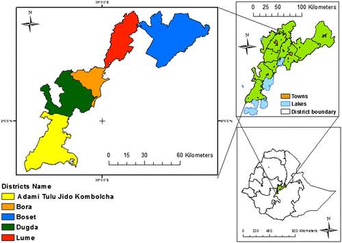
The study was conducted in five woredas (districts) located within the Central Rift Valley, in the East Shewa Zone (Figure ) which lies between 38°57′ and 39°32′ E and between 7°12′ and 9°14′N. The average altitude is 1600 m asl. Mid-highlands (1500–2300 m asl) constitute about 61% of the area, whereas the remaining parts of the zone are lowlands and highlands covering about 39%.
Figure 1. Map of the selected five semi-arid sites in East Shewa Zone, Oromia, Ethiopia.
According to data from the two meteorological stations located in the area (Adama, between the Boset and the Lume districts; Ziway, in the Adami Tulu Jido Kombolcha District), the climate is characterized by a six-month rainy season between April and September, and a six-month dry season between October and March. The mean annual temperature is 21 °C and the mean annual rainfall is 750–900 mm.
According to the zonal Statistics and Information Center, the major land uses are cultivation land (45%), bush and forest land (16%), grazing land (9%), water bodies (5%) and settlement (25%). The major types of soil may be categorized into Andosols, Vertisols, Cambisols, Regosols, Luvisols, Phaeozems and Fluvisols. Natural vegetation combines Acacia woodland and savannah. Across the Zone, grain crop and livestock farming are dominant, whereas in areas adjacent to the Rift Valley lakes and rivers, irrigated vegetable farming and horticulture are practiced. Pastoralism is more common towards the north-eastern, more arid, areas. Within the grain–livestock areas, the combination of crop and trees shows some variation: teff–wheat with Faidherbia albida to maize–beans–sorghum with Acacia tortilis across the north–south transect, and teff–wheat with F. albida to teff–maize–sorghum with A. tortilis across the west–east transect, while the livestock system is commonly communal/free grazing of animals.
Research design
The five woredas were selected purposively to represent the observed diversity in tree–crop systems. In each woreda, we selected a single kebele (the smallest administrative unit in Ethiopia) as representative of the local warm lowlands (‘kolla’) agroecological conditions. The selected Woreda/Kebele were Boset/Sara Areda, Lume/Ejersa Joro, Bora/Berta Sami, Dugda/Jewe Bofo and Adamitulu Jido Kombolcha/Gerbi Widena Borommo. The sites are hereafter referred to as Boset, Lume, Bora, Dugda and Adamitulu Jido Kombolcha (hereafter called ATJK) following the Woreda names.
The tree inventory work was nested on the farmland area owned by the households that were surveyed for socio-economic characterization of the selected sites by Iiyama et al. (Citation2016). In each site, a total of 20 households were selected randomly. Among these households, 4 were selected randomly for a complete inventory of all existing trees and shrubs on all parcels owned by the household. In the remaining, 16 households, inventories were made only on the main homestead parcels. For this study all the parcels of land belonging to the sampled households and recorded on farmers’ land certificates were considered. Homestead was defined as the nearest farm parcel to the house including its front, back and side yards. It may have small crop fields inside and it is managed by family members, who use manure rather than artificial fertilizer. Farthest farm plots are those parcels outside of the homestead, which, among others, include the farmer’s main crop production area.
Data collection
All trees in each parcel of land were identified and recorded. Identification included both local and scientific name and was carried out in the field with the help of a field guide book (Bekele Citation2007). In addition, voucher specimens were prepared for all plant species that were recorded in the field, and deposited at the National Herbarium, Addis Ababa University.
In addition to homestead, four land use categories were identified as potentially harbouring trees: woodlot (area dedicated to small-scale production of wood), trees/shrubs in line (hedgerow, live fences, boundary planting), crop land (tree/shrub mixed with annual crops) and grazing land (area allocated for grazing in which crop is not grown and in which scattered trees can be found).
For each tree and shrub with a height greater than or equal to two metres, the number of stems was counted, diameter at breast height (DBH) and height were measured. In addition, in crop land, the crown of each tree (i.e. lengths of the longest spread from edge to edge across the crown and of the longest spread perpendicular to the first cross section through the central mass of the crown) was measured to estimate the canopy cover of trees in crop land. Finally, trees with a height lower than 1 m (hereafter called ‘seedlings’) and trees with a height between 1 and 2 m (hereafter called ‘saplings’) were counted across all the parcels.
Further, the area of the surveyed farmlands, as reported in the land certificates issued to each farmer by the administration, was recorded. In addition, the area of each land use category was measured to make realistic comparisons on diversity and abundance among the land use categories identified in the study area.
Data analysis
Data were organized using spreadsheets and the Biodiversity. R software was used extensively for the diversity analysis. Density of individuals (trees, saplings and seedlings), species richness, Shannon diversity index and evenness were computed across sites and land use categories. Since grazing land was represented by a very few samples, it was not further considered during comparative analysis of the land use categories.
The standard diversity indices, Shannon and Wiener (H’), evenness (E) and Simpson (1-D) (Magurran Citation2004) were computed in Biodiversity.R. In order to express the difference in species composition or the ecological distance between samples, we used the Bray–Curtis distance (Bray & Curtis Citation1957), which varies from 0 (composition identical) to 1 (no species in common).The species matrix was here square root transformed to reduce the influence of the dominant species in the analysis (Kindt & Coe Citation2005). In addition, rarefaction curves, here defined as the statistical expectation of the number of species in a survey as a function of the accumulated number of individuals (Colwell Citation2009), were constructed for each land use category using EstimateS (Colwell Citation2013).
Further, the relative values of density and dominance (basal area) for each species in the landscape were computed as the percentage of individual values to the total values for comparing the ecological significance of each species (Lamprecht Citation1989). In addition, average crown size, average crown area and total crown area per ha were computed for each species encountered in the crop land use category. Furthermore, the overall population structure was analysed through construction of frequency distribution of all the individuals encountered in arbitrarily assigned diameter and height classes. Six diameter classes and four height classes were recognized arbitrarily.
Finally, Spearman correlation analysis was carried out in SPSS 20 between land-holding size and tree parameters (abundance, basal area and richness).
Results
Tree species abundance, diversity and composition across the major land use categories.
The land use categories, their major tree species and the purposes of each land use practice are presented in Table .
Table 1. List of land use categories and their characteristic features in the five semi-arid sites in East Shewa.
The 100 households sampled own a mean land area of 2.73 ha (±2.15 ha) distributed over 4(±2) land parcels on average. The sampling strategy we used allowed us to effectively sample 27.9% (76.09 ha) of their land-holding area and 43.5% (172) of their land parcels. In each parcel, one or more land use categories were identified, and in total there were 102 homestead, 88 crop land, 65 line planting (64 boundary planting and 1 hedgerow), 15 woodlot and 3 grazing land plots (Table ). About 42% of the homesteads had small crop fields in their area.
Table 2. Tree density and tree species diversity among the different land use categories in the five semi-arid farmland sites sampled in the East Shewa Zone, in decreasing order of diversity.
A total of 77 woody plant species representing 32 families were identified and recorded in all the 172 parcels (i.e. on the above-listed 273 land use plots). Of all the species identified 26% belonged to the Fabaceae family, 7.8% to Capparidaceae and 7.7 to Euphorbiaceae, and these were the three dominant woody plant families in the landscape.
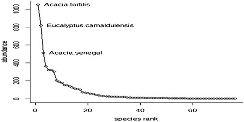
Among the total number of species, only 30% were exotic, while the remaining 70% were indigenous (Appendix 1). Of all the species, A. tortilis, Eucalyptus camaldulensis and Acacia senegal were the most abundant tree species with 13.8, 10.7 and 6.7 individuals per ha, respectively (Figure ).
Figure 2. Rank abundance curve of all species in five semi-arid sites in East Shewa Zone.
As indicated above, a high tree species diversity (i.e. a total of 77 species) was recorded in farmlands of the study area when the data were pooled together. The tree density varied from 55 trees per ha in ATJK to 100 trees per ha in Dugda, while species richness varied from 25 in ATJK to 56 in Dugda (Table ).
Table 3. Tree species abundance, richness, evenness and diversity in the five semi-arid farmland sites sampled in East Shewa Zone, in decreasing order of diversity.
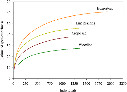
The average number of tree species per parcel over the 172 parcels sampled was 4.7 (±4.4) ranging from a treeless condition in one homestead and nine crop lands to 36 species in one of the homesteads. Tree density, species richness and diversity were different among the different land use categories (Table ). Average tree density was 80 trees per ha, but it varied across the land uses, from 19 trees per ha on crop land to 1216 trees per ha in line plantings. The highest values of density, species richness, Shannon and Simpson diversity indices, were recorded in homesteads and line plantings. This was confirmed by the rarefaction curves which show the steepest slopes for these two land uses (Figure ).
Figure 3. Rarefaction curves comparing species among land use categories in five semi-arid sites in East Shewa Zone.
Out of the 6066 individual trees encountered in our samples, about 56% were established through natural regeneration and the remaining 44% were established through planting. Most trees in line planting (66%) and woodlot (56%) were planted while most trees in grazing land (100%), in crop land (94%) and homestead (61%) were naturally regenerated (Appendix 1).
According to the Bray–Curtis distance matrix, the ecological distance between any two land use categories varied from 0.47 to 0.77 (Table ). The crop land and homestead land use categories showed the least distance and thus the highest similarity.
Table 4. Bray–Curtis distance between land use categories (based on tree species abundance) in five semi-arid farmland sites in the East Shewa Zone.
Trees in crop land
Ten different crops were found cultivated on the sampled parcels of crop land. The most abundant were maize and teff with 45.9 and 32.2% of the total area surveyed, respectively. The other eight crops encountered were: common bean, wheat cabbage, haricot bean, pea, barley, cow pea, potato, pigeon pea and lablab bean.
Trees in crop land parcels had an average crown spread of 3.1 (±1.4) m, and an average canopy area of 9.1 (±7.3) m2. The average tree density was 19 trees per ha of crop land, and the average canopy area density was 230.7 m2 per ha. It implies that the percentage of the crop land under tree canopy cover was only 2.3%. A. tortilis (6 m) and Cordia africana (5.5 m) trees had the highest average crown spread, with an average crown area of 28.2 and 23.5 m2, respectively (Table ). However, C. africana was anecdotic in cropland with only three trees in our whole sample, and thus A. tortilis is by far the most important tree in the crop land landscape with a total crown area of 123.5 m2 per ha
Table 5. Average crown spread, average crown area and total crown area of trees on crop land in five semi-arid sites in East Shewa Zone, in descending order of ACA.
Population structure and regeneration status of trees
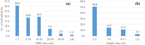
The overall diameter distribution pattern of trees with height 2 m and above was an inverse J shape with 30.8 individuals per ha (about 39%) found in the first lower DBH class, while the remaining 49 individuals per ha (61.4%) were distributed in the remaining four DBH classes. Similarly, the distribution of heights was an inverse J shape where 51.6 individuals/ha (about 64% of the individuals) had height of 2–5 m, and the remaining 29 trees per ha (about 36%) were distributed over the rest of the classes (Figure ).
Figure 4. Tree height and diameter structure in five semi-arid sites in East Shewa Zone.
The analysis of basal area and density per species showed that A. tortilis, E. camaldulensis and A. senegal were the three most important species structurally in the farm landscapes studied (Table ).
Table 6. List of the top 15 dominant tree species, in decreasing order of relative density and basal area.
The regeneration population in the surveyed farmland landscape was composed of a total of 1094 seedlings and 1560 saplings, which implies an average regeneration density of around 35 young trees per ha. From the total 76 recorded tree species 25 species had seedlings and 34 species had saplings (Table ). From naturally regenerated plants A. tortilis and Croton macrostachyus followed by A. senegal, Balanites aegyptiaca and Dichrostachys cinerea had relatively high regeneration capacity even with the presence of disturbance by farmers during land preparation and other activities. On the other hand, Jatropha curcas and E. camaldulensis both had a high number of newly planted individuals.
Table 7. Density (number of individuals/ha) of the regeneration population of tree species (seedlings and saplings of native and exotic tree species) in the five study sites and its relative proportion to the total regeneration population in East Shewa.
Is land-holding size correlated to tree parameters?
Tree species diversity seems to be influenced by land-holding size. The investigated farmers owned various farm sizes; most farmers (59%) have less than 0.5 ha, whereas the remaining 22, 10 and 9% farmers have landholdings between 0.5 and 1 ha, 1–2 ha, and more than 2 ha, respectively. Spearman correlation analysis revealed that land-holding size had significant (p < 0.05), positive relationships with abundance and basal area, but not with species richness.
Discussion
The fact that A. tortilis and A. senegal are the most abundant species in our sample is in agreement with Iiyama et al. (Citation2016) which reported A. tortilis as the most abundant species in farmers’ fields. It is also partly in agreement with earlier reports in the Central Rift valley area (Abate et al. Citation1998; Woldu et al. Citation1999) where our results show that E. camaldulensis is becoming one of the abundant species in the landscape.
The species richness, 77 tree species on 76 ha, was low when compared to a similar extensive study in the Mount Kenya area that found 297 tree species on 60 ha of smallholders’ farms (Lengkeek et al. Citation2005). However, this difference in richness may be attributed to site characteristics, including climate and predominant land use: the slopes of Mount Kenya have a much more humid climate than the semi-arid Oromia, and the main land use of the farms is coffee agroforests, which are characterized by a very high density of multipurpose trees (average density of non-coffee trees: 1048 trees ha−1) in addition to coffee trees. Negash et al. (Citation2012) argued that indigenous agroforestry systems should be recognized as a valid option for maintaining native woody species which populations in the wild are threatened in the south-eastern Rift Valley escarpment in Ethiopia. The 77 tree species found managed in our sample of farmlands give credence to this argument, as they clearly show the importance of farm landscapes in species preservation in the semi-arid areas of the Rift Valley.
In this study, we have reported and also depicted in the rarefaction curves that there are differences in species richness among the different land use categories. Duguma and Hager (Citation2010) also reported significant difference in species richness and abundance among land use practices in the central highlands of Ethiopia. The highest diversity in homesteads and line plantings may be due to the short distance from home (and consequently better care) and to a more active tree management than in crop lands. The crop lands face immense pressure from the open grazing, which hampers tree establishment and regrowth in the area. The unusually high tree diversity and low density in the woodlots was due to the fact that some of them were patches of remnant woodlands.
The low Bray–Curtis distance between crop land and homestead was perhaps due to the presence of similar numbers of trees of the dominant Acacia species, specifically A. tortilis (408 and 333) and A. senegal (115 and 120) in the homestead and crop land, respectively. Further, the existence of crop land plots within 42% of the homestead areas could have contributed to the high similarity between the two land use categories.
The mode of regeneration reported here is in agreement with the findings of Iiyama et al. (Citation2016) who reported that farmers in the Rift Valley use farmer managed natural regeneration (FMNR) as the principal strategy of tree establishment.
The fact that some of the trees in crop lands have large canopies could have a negative impact on crop production unless the trees have a facilitation role. However, a local knowledge study in the area found out that farmers retain trees with large crowns such as A. tortilis since they value their other multiple uses even if it would mean lower crop production (Ataa-Asantewaa Citation2013). Some farmers in the study area tried to manage trees in the crop lands by pollarding tree branches in order to save crops from competition for light as well as utilize the branches for other uses like fencing. Besides the tree management to reduce competition with crops, the very low level of tree canopy cover in crop land indicates that there is probably ample room to increase the current level of tree cover, either through FMNR or planting, which could help improve the productivity and resilience of the system simultaneously.
The overall population structure in the study area was characterized by a large population of small trees, which could be related to a large shrub population and to a large population of young trees. Such patterns of community structure have been reported for different types of populations such as in natural forests (e.g. Fashing et al. Citation2004), and in agriculture fallows (e.g. Kalaba et al. Citation2013) in various parts of the globe. They are generally interpreted as a sign of relatively good health of the ecosystem.
However, the ratio of the adult trees to the regeneration population (saplings and seedlings) at community level stands at 80:35. This means that in a hectare of land there are 80 individuals with height 2 m and above, and there are 35 with height less than 2 m. A closer look at the first class in the height structure (i.e. 2–5 m) shows that there are close to 51 individuals in this class. Although farmland is not a forest, planned intervention may be needed for boosting the establishment of trees through managing natural regeneration and/or planting, and for handling the issue of free grazing which leads to extensive / unsustainable browsing, especially during the dry season.
The significant positive relationship between land-holding size and both the number of trees and basal area on the farm means that small farms have less trees than large farms, and this is probably due to land limitation. These findings are in agreement with Duguma and Hager (Citation2010) who found that land-holding size is one of the important socio-economic factors that significantly influence possession of shrub stems in the central highlands of Ethiopia. The lack of significant relationship between land-holding size and species richness may be explained by the fact that species diversity is concentrated in homestead (62 species) which represents only a minor area of the sampled farmlands (20%), while crop land which represents the major part of the sampled farmlands (73%) harbours much less species (37). It also could be explained by the limited availability of good quality and diversified planting material suitable for crop land.
Conclusion
The study has highlighted the tree species composition, diversity, abundance, population structures, canopy size and regeneration conditions across four land use categories in five semi-arid sites. The overall landscape is predominantly characterized by diverse tree species found in higher density in homesteads and line plantings, and scattered in parkland agroforestry systems where they are integrated with crop production and grazing management. The species composition is dominated by native species which are retained or regenerated naturally, and to some extent planted by farmers. However, farmers are also planting exotic species with an important economic role such as E. camaldulensis, which is becoming one of the dominant tree species in the landscape. Land-holding size differences contributed significantly to the marked differences in species abundance and basal area. As hypothesized tree species diversity was the highest close to the home (homestead area and line plantings). However, against our hypothesis, diversity (species richness) was not affected by land-holding size. The low tree density in crop lands and the low regeneration population in the landscape may require targeted intervention to increase tree cover in the area through FMNR or planting of suitable trees so as to improve the resilience of the farming system in the face of climate change. Providing quality seedlings of various tree species suitable for the area would substantially increase farmers’ range of options for planting. The challenge of water scarcity and free grazing practice which is predominant in this area needs also to be addressed in order to enhance survival of newly planted tree seedlings and naturally regenerating ones.
Disclosure statement
No potential conflict of interest was reported by the authors.
Funding
This work was supported by the International Centre for Research in Agroforestry (ICRAF) under the Australian Centre for International Agricultural Research (ACIAR) [32016112 ACIAR 1014.12254NBR] Trees for Food Security Project.
Acknowledgements
We are grateful to ICRAF Ethiopia office for the facilitation of this work. Our special thanks go to all farmers and development agents who participated in this study and provided relevant information. We are also grateful to Mr Mindaye Teshome for his help in producing the rarefaction curves. We are very greatly indebted to the anonymous reviewers and Dr Hubert de Foresta for the critical review, corrections and suggestions given for improvement of the manuscript.
References
- Abate A, Fetene M, Woldu Z. 1998. Investigations on canopy features of three indigenous woodland tree species of Ethiopia. SINET Ethiop J Sci. 21:113–132.
- Ataa-Asantewaa M. 2013. Local knowledge of farmers on farm tree management, East Shewa Zone, Ethiopia [dissertation]. Bangor, ME: Bangor University.
- Atta-Krah K, Kindt R, Skilton JN, Amaral W. 2004. Managing biological and genetic diversity in tropical agroforestry. Agrofor Syst. 61:183–194.
- Baudron F, Mamo A, Tirfessa D, Argaw M. 2015. Impact of farmland exclosure on the productivity and sustainability of a mixed crop-livestock system in the Central Rift Valley of Ethiopia. Agric Ecosyst Environ. 207:109–118.10.1016/j.agee.2015.04.003
- Bekele A. 2007. Useful trees and shrubs for Ethiopia: identification, propagation and management for 17 agro climatic zones. Nairobi: World Agroforestry, Centre East Africa Region.
- Bray JR, Curtis JT. 1957. An ordination of upland forest communities of southern Wisconsin. Ecol Monograph. 27:325–349.10.2307/1942268
- Colwell RK. 2009. Biodiversity: concepts, patterns, and measurement. In: Levin SA, editor. The Princeton guide to ecology. New Jersey: Princeton University Press; p. 257–263.
- Colwell RK. 2013. EstimateS: statistical estimation of species richness and shared species from samples. Version 9 [Internet]. Available from: http://purl.oclc.org/estimates.
- Duguma LA, Hager H. 2010. Woody plants diversity and possession, and their future prospects in small-scale tree and shrub growing in agricultural landscapes in central highlands of Ethiopia. Small Scale For. 9:153–174.10.1007/s11842-009-9108-0
- Fashing PJ, Forrestel A, Scully C, Cords M. 2004. Long-term tree population dynamics and their implications for the conservation of the Kakamega Forest, Kenya. Biodivers Conserv. 13:753–771.10.1023/B:BIOC.0000011724.34275.73
- Garedew E, Sandewall M, Söderberg U, Campbell BM. 2009. Land-use and land-cover dynamics in the Central Rift Valley of Ethiopia. Environ Manage. 44:683–694.10.1007/s00267-009-9355-z
- Garrity D. 2004. Agroforestry and the achievement of the millennium development goals. Agrofor Syst. 61:5–17.
- Garrity D, Akinnifesi F, Ajayi O, Weldesemayat S, Mowo J, Kalinganire A, Larwanou M, Bayala J. 2010. Evergreen agriculture: a robust approach to sustainable food security in Africa. Food Sec. 2:197–214.10.1007/s12571-010-0070-7
- Hengsdijk H, Jansen H. 2006. Agricultural development in the Central Ethiopian Rift Valley: a desk-study on water-related issues and knowledge to support a policy dialogue. Wageningen: Plant Research International B.V.
- Iiyama M, Derero A, Kelemu K, Muthuri C, Kinuthia R, Ayenkulu E, Kiptot E, Hadgu K, Mowo J, Sinclair FL. 2016. Understanding patterns of tree adoption on farms in semi-arid and sub-humid Ethiopia. Agrofor Syst. doi:10.1007/s10457-016-9926-y.
- Kalaba FK, Quinn CH, Dougill AJ, Vinya R. 2013. Floristic composition, species diversity and carbon storage in charcoal and agriculture fallows and management implications in Miombo woodlands of Zambia. Forest Ecol Manag. 304:99–109.10.1016/j.foreco.2013.04.024
- Kindt R, Coe R. 2005. Tree diversity analysis: a manual and software for some common statistical methods for biodiversity and ecological analysis. Nairobi: World Agroforestry Centre (ICRAF).
- Lamprecht H. 1989. Silviculture in the tropics. Tropical forest ecosystems and their tree species - possibilities and methods for their long-term utilization. Eschborn: GTZ; p. 296.
- Lengkeek AG, Kindt R, van der Maesen LJG, Simons AJ, van Oijen DCC. 2005. Tree density and germplasm source in agroforestry ecosystems in Meru, Mount Kenya. Genet Res Crop Evol. 52:709–721.10.1007/s10722-003-6021-9
- Magurran AE. 2004. Measuring biological diversity. Oxford: Blackwell; p. 256.
- Negash M, Yirdaw E, Luukkanen O. 2012. Potential of indigenous multistrata agroforests for maintaining native floristic diversity in the South-Eastern Rift valley escarpment, Ethiopia. Agrofor Syst. 85:9–28.10.1007/s10457-011-9408-1
- Safriel U, Adeel Z. 2005. Dryland systems. In: Hassan R, Scholes R, Ash N, editors. Ecosystems and human well-being, current state and trends, Vol. 1. Washington (DC): Island Press; p. 625–658.
- Sanchez P, Buresh R, Leakey R. 1997. Trees, soils, and food security. Phil Trans R Soc London Biol. 352:949–961.10.1098/rstb.1997.0074
- Tanga AA, Erenso TF, Lemma B. 2014. Effects of three tree species on microclimate and soil amelioration in the Central Rift Valley of Ethiopia. J Soil Sci Environ Manage. 5:62–71.
- Woldu Z, Fetene M, Abate A. 1999. Vegetation under different tree species in Acacia woodland in the Rift Valley of Ethiopia. SINET Ethiop J Sci. 22:237–254.
- Yeo D. 2014. Thinking to practice: applying complexity the water-food-energy nexus in global drylands: bridging science and policy. Barcelona: Barcelona Centre for International Affairs.
Appendix 1.
List of plant species, origin, establishment modes and number of individuals encountered in different land use categories in five semi-arid sites in East Shewa Zone
Notes: N = Native, E = Exotic, EM = establishment mode, R = Naturally Regenerated, P = Planted, Or = Oromifa, Amh = Amharic, HS = Homestead, CL Crop land, GL = Grazing land, LP = Line planting, WL = Woodlot, Density = number of individuals/ha.