
ABSTRACT
It is widely acknowledged that marine spatial planning (MSP) should be responsive to the dynamism of the marine environment and the relatively tenuous human relationship with the sea. However, MSP remains conceptualised within rationalistic terms that limit this potential. This article places MSP within the context of spatial theory that holds greater promise for developing more progressive practice. Firstly, the interrelation of MSP with current notions of soft space (less formal, cross-cutting spatialities) is explored, suggesting that MSP is expressing some of the geographical and institutional freedoms of soft space, and may contribute new insights to this concept. Secondly, a progressive framework is developed that builds upon soft space principles. This draws in, on the one hand, underlying relational understandings of space, and on the other hand, insights from marine contexts. This leads to a picture of marine space-being-planned as lively space, expressing, amongst other things, the sea’s materiality. This concept is illustrated through an application of the framework to a strategic MSP exercise for the Baltic Sea region. Finally, it is suggested that MSP itself should be reconceptualised as immersed into this spatial ontology, with the agents and practices of planning taking their place within the wider assemblage of marine actants and relations.
Introduction
Marine spatial planning (MSP)Footnote1 aims to manage the marine environment and maritime activities more rationally than hitherto (Douvere, Citation2008; Gilliland & Laffoley, Citation2008). Scientific arguments have been put forward, pilot exercises have been carried out, policy development has led to statutory systems of MSP and marine plans have now been completed for a number of areas around the world (Douvere & Ehler, Citation2009; Jay et al., Citation2013; UNEP & GEF-STAP, Citation2014; UNESCO, Citationonline). One of the most significant developments has been a European Union (EU) directive requiring coastal Member States to implement MSP (the ‘Maritime Spatial Planning Directive’) (EPC, Citation2014).
MSP takes its inspiration from the long-standing practice of spatial planning on land, with the assumption that it can be transferred, with some adaptation, to the sea. However, fundamental differences between these planning contexts are acknowledged, relating to: the sea’s dynamic physical characteristics and ecological fragility; the more mobile and less constrained nature of human activities; weaker patterns of ownership of marine space and resources; lesser accessibility and permanence of settlement; and more uncertain consequences of actions (Crowder & Norse, Citation2008; Jay, Citation2010; Kidd & Ellis, Citation2012; Tyldesley, Citation2004). These marine realities suggest a more tenuous and changeable, less graspable and controllable planning context: aspects that have arguably kept planning on land until recently.
MSP could therefore be interpreted as an overly-simplistic attempt to introduce the practices of spatial planning to the planning-resistant sea. Some of MSP’s manifestations, such as comprehensive zoning, may well be critiqued as too inflexible for handling complex marine dynamics (Jay, Citation2013). On the other hand, it could be argued that the advent of MSP is an expression of wider shifts in spatial planning itself, now being used to develop plans in more open and exploratory terrestrial settings, particularly at strategic levels (see, for example, Healey, Citation2004; Sartorio, Citation2005; van Schaick & Klaasen, Citation2011). MSP may therefore be one of planning’s new frontiers, characterised by such thing as greater engagement with environmental imperatives and participatory ideals (Cullingworth et al., Citation2015).
In this article, I explore the second of these possibilities. This arises from the conviction that if MSP is to extend the scope of planning, it should develop practices that are responsive to the more dynamic and uncertain characteristics of the sea, rather than being constrained by rationalistic approaches less well-equipped to address these challenges (Jay, Citation2010; Tafon, Citation2017). I seek to contribute to this agenda by developing a more versatile understanding of marine space itself, particularly as it is encountered within MSP processes, and pointing to the implications of this for MSP practice.
I set about this, firstly, by considering spatial planning thinking that is critiquing accepted conventions of planning as overly limiting with regard to the definition of territories and spatial processes. This focuses on the notion of ‘soft space’ (Allmendinger & Haughton, Citation2009b), a concept that draws into planning the significant reinterpretations of space that have taken place in cultural geography (Murdoch, Citation2006). MSP has not previously been placed within this context, and the discussion below suggests that, in some respects, MSP can be understood as an expression of soft space planning. At the same time, the experience of MSP brings new dimensions into the soft space discussion, implying that MSP can take the notion further than is possible in the terrestrial settings where it has its origins, to the point where more radical conceptualisation is needed.
Secondly, I develop a framework that encapsulates a more progressive understanding of marine space and MSP practice. This is based upon the principles of soft space thinking, but also draws in additional insights, on the one hand, by reaching back to some of the relational ideas underpinning the concept of soft space, and on the other hand, by introducing marine realities as expressed in ongoing MSP debate.
Thirdly, this framework is applied to a particular MSP initiative; an MSP strategy for the Baltic Sea region, which reflects and affirms many of the framework’s themes. I then suggest that marine contexts introduce a level of dynamics that are inadequately captured by current planning terms but that may be better understood as ‘lively space’. Finally, the idea of ‘immersed planning’ is introduced to describe a more responsive approach to MSP.
Soft space and MSP
In a series of publications, Allmendinger & Haughton have developed the notion of soft space as a means of expressing more flexible approaches to the territories and processes of spatial planning. Observing trends in planning practice (mostly at strategic scales), they have noted new spaces being created for particular purposes, not constrained by geographical and organisational boundaries, in that they transcend conventional planning areas and bring together new configurations and forms of collaboration.
These observations were initially made in the context of UK governance reforms that were driving new approaches to spatial development (under ‘new Labour’ administrations, 1997–2010). These included: the devolution of powers away from central government and the associated rescaling of planning; a shift from centrist control to participatory governance, in which the state, private enterprise and civil society collaborate; integration of policy spheres, especially those with a spatial dimension; and a broadly neoliberal agenda favouring entrepreneurial development (Allmendinger & Haughton, Citation2007, Citation2009b, Citation2010, Citation2014; Haughton, Allmendinger, Counsell, & Vigar, Citation2010). Interestingly, MSP policy developed during this same period in the UK, with the system of ‘marine planning’ exhibiting similar trends, such as transfer to devolved administrations, a stakeholder-centered approach, sectoral integration ambitions and economic and environmental objective-setting (Claydon, Citation2006; Defra, Citation2007, Citation2011; Hull, Citation2013). These characteristics also echo the precepts of MSP promoted internationally (Douvere, Citation2008; Jay, Citation2010).
Soft spaces thus reach beyond conventional administrative and institutional boundaries. They take into their scope whatever geographies are suited to the matter in hand, possibly with indeterminate borders and open to expansion. Planning territories may be irregular, with incomplete or overlapping coverage and scalar shifts between them. New participants are welcomed and diffused patterns of power may emerge. Innovative, sometimes informal, planning processes may develop, suited to cross-border and cross-sectoral working with room for manoeuvre. Soft spaces have less clearly-defined, ‘fuzzy’ boundaries and forms of organisation, and tend to sit alongside more established statutory planning spaces and processes (Allmendinger & Haughton, Citation2007, Citation2009b, Citation2010, Citation2014). They have been described as ‘informal or semi-informal, non-statutory spatialities of planning with associations and relations stretching both across formally established boundaries and scalar levels of planning and across previously entrenched sectoral divides’ (Metzger & Schmitt, Citation2012, p. 265f).
Links with MSP experiences immediately suggest themselves. In particular, a series of pilot projects have been conducted that do not map onto formal territories nor have been led by official agencies. This is partly because they predate the establishment of boundaries and regulatory processes for MSP, but also because in a start-up phase, capacity-building and experimentation are called for, such as creating new knowledge bases and drawing together new sets of participants (Ehler & Douvere, Citation2007; Flannery & Ó Cinnéide, Citation2012; Gopnik et al., Citation2012; Vincent et al., Citation2004). Several of these projects involved transboundary areas and bodies of actors (Backer, Citation2011; Flannery, O’Hagan, O’Mahony, Ritchie, & Twomey, Citation2015; Hassan, Kuokkanen, & Soininen, Citation2015). For example, a project in the Irish Sea stressed cross-border relations at all levels of working; it also took a graded approach to transboundary considerations whereby interest diminished with distance from the border area rather than met a hard boundary (Jay, Citation2015). Some of these exercises also exhibit the soft space notion of a ‘spatial imaginary’ as they seek to create a preferred reality through the act of representation (Haughton & Allmendinger, Citation2015). For instance, a Portuguese study presented ambitious arrangements for a host of activities throughout the mainland’s marine territory, including emerging technologies such as wave energy and the cultivation of seaweed for biofuel (Calado et al., Citation2010; Frazão Santos, Domingos, Ferreira, Orbach, & Andrade, Citation2014).
‘Fuzzinesss’ can also be read into uncertainties over the precise boundaries of the new marine planning spaces. One difficulty has been deciding on the landward extent of marine spatial plans; whether they should abut with terrestrial administrative areas (typically at the low water line), overlap with terrestrial areas along an intertidal or coastal strip (in the interests of taking into account land-sea interactions), or extend their reach further inland (recognising, for example, that river basins shape the marine environment) (Kerr, Johnson, & Side, Citation2014; MSPP Consortium, Citation2006). Similarly, in some contexts, subdividing national marine territory into plan areas has faced conflicting logics about ecosystems, administrative divisions, use-pressures and so on, with uneasy compromises being made to create workable planning units (Defra, Citation2009; Gilliland & Laffoley, Citation2008). It remains to be seen whether these pragmatically-defined areas will harden into discrete cells or continue to be negotiated and adjusted, possibly with ambiguous edges and overlaps. Similarly, here has been a preference for broad spatial indications, or ‘soft zoning’ in some contexts (Kelly, Gray, Shucksmith, & Tweddle, Citation2014).
These examples also demonstrate the international take-up of MSP, with Europe a strong focus of attention at present; here, the soft space concept of reworking the scales of planning also comes to the fore (Allmendinger & Haughton, Citation2014). EU initiatives (CEC, Citation2008; Qiu & Jones, Citation2013 suggest that marine space is being brought into the service of territorial cohesion (Zaucha, Citation2014), an extension, perhaps, of more established extra-territorial spaces intended to achieve EU aims (Faludi, Citation2010). Countries around each of Europe’s sea basins are being encouraged to cooperate in MSP, with the seas becoming a source of regional nexuses. Several of the pilot projects referred to above received EU funding with the intention that they work to this end (EC, Citationonline). The fuzziness of international marine borders, at the limit of receding national competencies, with their unmarked boundaries and interpenetrating waters, characterise not the edges, but the centre, of these soft spaces. Here lies the opportunity for scalar reinvention: the encroachment of national territories across the water, meeting where governance is at its weakest, the physical environment at its most diffuse and cross-border movement (human and non-human) at its least controlled, justifies EU-led action. The case for cooperation and the creation of new planning spaces straddling multiple boundaries becomes unarguable (Suárez de Vivero, Citation2007).
Similarly, terrestrially-based discussion has extended Europe-wide, with ‘soft space-ing’ being read into planning exercises beyond the UK (Olesen, Citation2012; Purkarthofer, Citation2016; Stead, Citation2013). In a comparative north-west European study, Allmendinger et al. describe a ‘major proliferation of new territorial governance forms’ (Citation2015, p. 18), including extended city-regions and polycentric areas straddling urban boundaries. The authors seek to analyse the rationalities behind these initiatives and their relationship with more conventional planning processes. They suggest a more complex interplay of soft spaces with statutory systems of planning. This includes a stronger role being played by public authorities in developing alternative plans, and attempts to link soft spaces to formal processes and territories in the interests of securing greater legitimacy and powers of implementation. Interestingly, a similar trend can be seen in the EU-supported, transboundary MSP experiments mentioned above. Initially, these projects involved a range of institutions; where governmental agencies were involved, they were generally acting outside their regulatory remit. But in the most recent projects, official MSP authorities have, in the context of the directive on MSP, taken a stronger lead in working towards shared outcomes. There are echoes here of the hardening of multinational spaces observed in other policy-led drives for European integration (Allmendinger, Chilla, & Sieler, Citation2014).
The European dimension also draws attention to the growing influence of ‘spatial’ planning in facilitating new ways of working. This is in contrast to the narrower regulatory processes that characterising some planning systems, not least in the UK. Spatial planning, though variously understood, places emphasis on developing strategic visions of territories that integrate spatially-relevant policy areas, horizontally and vertically, and seeks to achieve comprehensive societal objectives. This is described in the soft space literature in somewhat tautologous terms to soft space planning itself (Allmendinger & Haughton, Citation2009a, Citation2010; Haughton et al., Citation2010). However, there are supportive descriptions of the rise of a distinctively encompassing and identity-building approach to planning (Albrechts, Citation2006; Friedmann, Citation2004; Tewdwr-Jones, Gallent, & Morphet, Citation2010). As suggested above, MSP owes its origins in part to these wider trends in planning practice; in the UK, for example, marine planning (despite the dropping of ‘spatial’ from the term) was heralded as an approach that will ‘bring together consideration of economic, social, cultural and environmental needs in the marine area’ (Defra, Citation2007, p. 19): this found favour with a professional planning body espousing the new spatial thinking (RTPI, Citation2007). Claydon suggests that it is ‘difficult to conceive of the translation of land use planning to the marine environment without an important recent conceptual shift’ in planning as a whole (Citation2006, p. i).
It should be noted, however, that despite the strong rhetorical emphasis on the spatial dimension within MSP discourse and some uptake of the flexibilities of soft space planning, the understanding of the spatial in MSP does not wholly reflect the trends experienced on land. References to the spatial usually assume a physically-deterministic understanding, expressing the aim of simply allocating space to functional uses (Ehler & Douvere, Citation2009; Jay, Citation2012). Although multi-actor engagement may contribute to this aim, the term ‘spatial’ has yet to embody the fuller range of ideas associated with it in wider planning thought. The example described below suggests the potential for a wider interpretation along these lines.
Another key aspect of soft space planning is that it is generally linked to entrepreneurial, neo-liberal agendas, by which the scalar and integrative opportunities offered by the new planning exercises serve underlying socio-economic ambitions and give a prominent role to private sector actors (Allmendinger, Tewdwr-Jones, Knieling, & Othengrafen, Citation2015). A marine example may be that of the UK’s business-model Crown Estate, which has worked closely with government in planning offshore renewable energy and has developed its own Geographic Information System (GIS) tool to support the siting of wind arrays (The Crown Estate, Citationonline). Another example is the six Pacific nations that have formed a partnership for the Coral Triangle with a view to strengthening the governance and planning of its resources (NIRAS, Citation2017). This has been described as an entrepreneurial exercise, in that change-makers came together to respond to specific challenges and opportunities (Rosen & Olsson, Citation2013). More generally, however, MSP-type exercises place greater emphasis on environmental objectives, often blurring with marine conservation programmes (Jones, Lieberknecht, & Qiu, Citation2016). Within the EU, for example, MSP is interacting with environmental legislation which has created its own ecological territories and organisations (under the Marine Strategy Framework Directive) (Thiel, Citation2013), with some influence on the scales and remit of MSP (Brennan, Fitzsimmons, Gray, & Raggatt, Citation2014).
It is worth noting that there has already been a seaward glance in the soft space literature. Some terrestrially-based spatial strategies traverse coastal or marine areas or expand into maritime hinterlands. Taking advantage of their soft space freedom, these initiatives look to the geographies, institutional mixes and development opportunities lying beyond the shoreline. For instance, estuaries have been described as a particular type of soft space, as attempts are made to bridge the administrative and cultural differences that have formed around them. New spaces have emerged around water bodies that historically represented division but which are now, in an alternative imaginary, the positive source of regional identity (Haughton & Allmendinger, Citation2015). In one case, the open sea is also drawn into the picture; north-west England’s Atlantic Gateway brings the far-reaching networks of maritime trade into the heart of regional economies via port and inland waterway development (Deas, Haughton, & Hincks, Citation2015; Dembski, Citation2015). At a European level, sea basins have become a focus and resource base for transnational regionalism.
‘Watery’ language has also come into play. Spatial scales are in a state of flux, and planning processes, even space itself, are fluid rather than fixed (Allmendinger & Haughton, Citation2007). Reference is made here to the wider reinterpretation of space as relational, ‘forever in a state of becoming, existing as nodal moments, temporary permanences or temporary constellations within ever-changing often far-reaching flows and networks’ (Haughton & Allmendinger, Citation2015, p. 860)). However, there is no reflection here on the actual materiality of estuarine or marine spaces, nor the implications that this might have for planning efforts, other than the metaphorical allusion to fluidity. MSP experience might be expected to take things furtherhere. For example, the strong awareness of the power and movement of the sea might reinforce notions of planning efforts being driven by dynamic and often physical realities that lie beyond the traditional remit of planning. Marine insights may push soft space thinking further in the direction of planning needing to engage with the naturally-determined and shifting, unsteady matrix of its working environment.
There is a danger in pursuing the notion of soft space of it taking on an ontological character of its own, as implied in a rather taxonomical description of soft spaces (Allmendinger & Haughton, Citation2014) and statements such as ‘What are soft spaces … ?’ (Allmendinger et al., Citation2015, p. 4). It is sufficient rather to describe a set of trends characterising planning efforts. It is in this sense that MSP may make a distinctive marine contribution to the notion. The examples alluded to above point towards the following.
In the marine context, informal planning is a preparation for formal processes, as it predates the establishment of administrative boundaries and regulatory responsibilities and encourages participation and knowledge-building.
The release of vast new realms of physical space to planning, including for developing pioneering technologies, invites open and visionary thinking and portrayal of future activities.
Transboundary initiatives are being driven not simply by shared cross-border interests, but by an interest in the border area itself, which, as a place of transition and permeability (the soft middle), needs special attention to movement and exchange across it, with importance diminishing with distance from the border (graded edges).
Continuous natural and social movement between land and sea and throughout sea areas calls into question the integrity and permanence of hard administrative demarcations between them.
Interlinked environmentally-oriented strategies and drivers introduce scientifically-defined scales of operation and rationales.
Within Europe, sea basins becoming ‘planned space’ creates a new rationale for interlinkages across shared waters in the interests of territorial cohesion.
There are limits to the extent to which MSP can currently be described as adopting the principles of soft space planning. For instance, a physically-static understanding of the ‘spatial’ predominates, with use-zoning being the ultimate ambition of many efforts. Nonetheless, MSP may be able to progress the notion further, with more flexible and responsive approaches lying latent in understandings of the dynamic materialism of the sea and the contingency of human activities upon it.
A framework for progressing the notion of soft space
In order to build upon the insights of soft space thinking, particularly with a view to developing more versatile MSP practice, I construct here a framework that describes aspects of a more progressive understanding (). This framework has been constructed from three fields. The central one is the soft space argument within planning; the features described above are drawn into the column ‘Soft space approaches to spatial planning’ without further discussion. Alongside this, I bring in ideas from planning and geographical thought that underpin the idea of soft space and reinterpret the notion of space itself. This assumes aspects of this wider discussion broadly characterised as relational understandings of space which are pertinent to marine adaptations of soft space. These are drawn into the column ‘Relational conception of space being planned’. I elaborate further on this field below. Finally, I introduce the contribution made by the emergence of MSP, embodying understandings and sensitivities about the marine world; these are summarised in the column ‘Additional insights from marine contexts’. These are touched upon in the section above and are discussed further below.
Table 1. A framework for progressing MSP.
Elements from these fields are organised by six overall ‘Descriptors’. These also reflect a relational ontology, organised as a narrative, suggesting a progression of complexity and co-dependence. These six words are intended to encapsulate and generalise the features described across the table and also motivate inquiry into, and possibly influence, new planning processes.
As well as having a descriptive purpose, this framework could be used for more systematic analysis. This follows the observation that although the soft space literature describes a range of principles, these are not set out in an analytical form that might help in investigating their uptake; analysis in the literature above is essentially discursive in nature. The present framework offers a more structured conceptualisation. It is expressed in terms that are sufficiently general to be used to query existing planning processes and, potentially, to shape them. It thus has empirical and normative purposes, intended to throw light on the extent to which planning processes are exhibiting signs of soft space or taking such notions further, or might be guided in this direction. (This follows the studies of Healey (Citation2004, Citation2007), similarly interested in relational developments in planning (see below)). In order to justify this framework further, I now enlarge upon the two dimensions wrapped around the soft space core.
Discovering relational understandings of space
In offering a less territorially-fixed interpretation of planning (Faludi, Citation2013), the soft space literature draws upon other re-workings of space in geography and planning. Most immediately, reference is made to urban studies where models of hierarchical and geometrical urban structures give way to dynamic and spatially-transcending patterns, reflecting the impact of global communication and socio-economic change. Here, sites become intersections of flows, and space is constituted of multi-scalar and temporal connections and networks (often translated into more socially-meaningful ‘place’) (Amin, Citation2002, Citation2015; Amin & Thrift, Citation2002; Graham & Marvin, Citation2001). The soft space emphasis on evolving, expanding, networked territories and governance resonates with these ideas. Connections with marine spatiality also suggest themselves here, such as the unbounded, mobile nature of the sea and many of its occupants, typically with a distant reach, interacting to create often-transitory configurations and human interventions (see the following section).
These urban studies rely upon wider theorising within cultural geography in which conventional physically-deterministic notions of space are rejected in favour of socially-constructed notions (Lefebvre, Citation1991); moreover, inter-relations between entities play a major role in those constructions (Massey, Citation2005). What are broadly referred to as relational views are set in contrast to the absolute, with emphasis upon interaction between subjects and objects and the proliferation of possibilities. This generally reflects a post-structuralist ontology, with multiple meanings attributable to places, arising from the immersion of subjects within systems of complex spatial relations (Murdoch, Citation2006). This shift from positivist and structuralist conceptualisations has been picked up directly in some planning studies, with descriptions of the spatialites and procedures of planning embodying the interacting, emergent, contingent and discursive nature of social processes (Boelens & de Roo, Citation2015; Davoudi & Strange, Citation2009; Friedmann, Citation1993; Graham & Healey, Citation1999; Healey, Citation2007; Hillier, Citation2007). Some attention has also been given to relational perspectives in MSP studies, with the sea’s inherent graded-ness and multiplicity of possible interactions arguing in favour of these perspectives (Jay, Citation2012; Knol, Citation2011).
However, incorporating human agents into change-producing webs de-centres them. This reintroduces the non-social into the ontology, in the form of active, non-human entities; human and non-human actants thus become co-producers of spatial patterns and outcomes. This has immediate appeal to planning, with its concern for the enveloping of people by the material, and for the shaping of human habitat; it is an attractive proposition to consider things as participants in planning processes, objects as potential allies with their own knowledge and power (Beauregard, Citation2015; Rydin & Tate, Citation2016). This approach also invites reconnection with natural sciences, especially with ecology, with its understanding of ecosystem as entities of finely-balanced and inter-dependent physical and biological elements (Lovelock, Citation1987; Odum, Citation1983). Hence humans are embedded into ecological systems, subjected to causal interactions as much as the rest, yet with unique reflective capacities to bring to bear on, for example, the co-production of spatial arrangements (Conley, Citation1997; Murdoch, Citation2006).
Indeed, the sea may well be thought of as a far more nature-dominated matrix than the land, where not even the most remote places offer anything equivalent to the physical forces, the unfamiliarity of biological life and the hidden depths of the oceans. These natural characteristics lie behind current geographical theorising, which, moving away from the conventional representation of the sea as a blank space, conceives of it as dimensional, powerful, replete with life and infused with human experience: an actor in its own right (Lehman, Citation2013). It offers the possibility of a heightened level of human connection with surrounding materiality, forming an assemblage of entangled interactions. Moreover, the fluidity of the sea embodies the ever-changing nature of connections, with fixes only ever temporary and the whole in a constant state of becoming (Anderson & Peters, Citation2014; Steinberg & Peters, Citation2015). Indeed, the undermining of human attempts at territorialisation by the likes of ‘currents, fish and dolphins’ has been effectively demonstrated (Bear, Citation2013, p. 25).
The notion of soft space thus connects with wider spatial theorising which can be described as offering a relational ontology in which connections and flows are predominant; it suggests continual mutation and openness to the future. This perspective also allows the non-human, and the material in general, as constitutive of spatial configurations. These aspects are heightened by emerging geographical and planning understandings of the sea and human engagement with it. In , the first two columns reflect this progression of thought.
Discovering the characteristics of the sea
One of the recurring themes within the promotion of MSP is the distinctiveness of the sea’ as compared to the landpresenting additional challenges to planning. These can be broadly understood as follows (Courtney & Wiggin, Citation2003; Defra, Citation2006; English Nature, Citation2003; Gilliland & Laffoley, Citation2008; Kerr et al., Citation2014; Kidd & Ellis, Citation2012).
Firstly, physical and biological differences are highlighted. Frequent reference is made to the three-dimensional nature of the space-to-be-planned, with activities possible above the surface, throughout the water column and under the seabed. Temporal variations introduce further complexity, as some activities have seasonal or other rhythms which influence their occupancy of space. Multiple use is more common and feasible. Fundamental to these accentuated dimensions is the materiality of the sea and its surroundings. Depth, movement, buoyancy and dynamism create very different conditions for biological life and human activities. Currents, waves and tides, climatic variations and weather patterns, transport of sediments and substances, movement and migration of organisms, and geological and coastal processes create shifting and powerful forces that create a radically different starting-point for planning than the relatively benign and stable terrestrial template (Crowder & Norse, Citation2008). Moreover, marine ecosystems are sensitive to change, such that human interaction can have far-reaching and unintended consequences. All this is compounded by a poor level of scientific understanding of the marine environment, with incomplete and ill-fitting data available, hindering efforts to protect valued habitats and species, locate human activities and understand their consequences. There is a scientific consensus that the sea has suffered serious environmental degradation as a result (UNEP, Citation2006).
Secondly, and linked to these characteristics, is the much weaker human ‘hold’ on the sea. This stems from the shorter history and limited nature of territorial control. It is only in recent decades that states have established sovereignty over waters beyond coastal zones through international law of the sea; moreover, national powers recede from one zone to the next outward from the coast, and extensive marine areas still lie beyond any national jurisdiction (Tanaka, Citation2015). Similarly, there are weaker forms of ownership of territory and resources at sea than on land. There is relatively little claim from non-state actors on the seabed, and rights of resource exploitation are state-controlled. The patterns of ownership that do exist are less differentiated, with the sea still regarded as a public good in many respects. These features are reflected in traditional patterns of use; shipping and fishing have benefited from the tradition of mare liberum, giving a universal right of passage and exploitation of common resources (Russ & Zeller, Citation2003). The extensive and more open pattern of jurisdiction and use rights is reflected in the general lack of physical, visible demarcation of areas, not to mention the much greater technical difficulties of trying to permanently mark out definitive areas at sea (Courtney & Wiggin, Citation2003). Equally, there are challenges in attempting to monitor activities over vast, largely unpeopled marine areas and to enforce rules about use of the seas.
Thirdly, and associated with the above, human activities are much less spatially dominant at sea than on land. Most activities have been mobile and transitory until recently; and although fixed installations are becoming more common, especially for energy supply, they are thinly dispersed and can hardly be described as equivalent to the built environment on land. In some respects, therefore, constraints to new activities are less pronounced. It might be added that marine interests are also more limited in their scope, restricted largely to functional uses such as transport and resource exploitation, alongside concerns for ecological well-being and cultural assets. The patchy nature of human intervention in the seas is also reflected in the administration of maritime activities; regulatory frameworks are sectoral, ad hoc, fragmentary and overlapping, in contrast to the more integrated and comprehensive processes that govern development on land. Likewise, public interest and representation in matters regarding the sea is less well-developed. Most fundamentally, it should not be forgotten that the sea has not been the normal place of human habitation; it remains distant, other and risk-laden for most people, unlike the security of terra firma.
These three groupings of issues, the sea’s natural dynamism, resistance to human control and shaping of human intervention, are expressed within the founding literature on MSP, perceived as challenges to be overcome and reinforcing the need for MSP. They provide the basis for the marine insights introduced to .
Exploring the uptake of relationality in MSP
To explore further whether this framework may help to progress MSP thought and practice, it was used to shape a reading of an MSP document. This was not with the intention of testing the actual uptake of the concepts within the framework (the examples referred to above suggest that any such uptake is partial and ad hoc), but simply to throw light on the possible resonance between the framework and MSP thinking. With this in mind, an affirming case was deliberately chosen, taken from the Baltic Sea region.
Interestingly, this region has already been the focus of soft space thinking. Metzger and Schmitt (Citation2012) saw the evolution of regional institutions and the EU strategy for the Baltic as an example of fluid, expanding governance spaces (see also Stead, Citation2013). These initiatives have been partly aimed at management of the sea itself, and the broader development of the region has taken the sea as its geographical fulcrum and basis of shared identity (CEC, Citation2009; Janssen, Kidd, & Kvinge, Citation2013). So it is no surprise that the Baltic Sea has been at the forefront of MSP initiatives, especially transnational projects with the backing of the cooperation organisations HELCOM and VASAB (Backer, Citation2011; Zaucha, Citation2014). These have been EU-funded projects involving research institutions, government bodies and stakeholders, illustrating well the non-statutory, multi-actor starting point of soft space planning.
BaltSeaPlan was one of these projects. Although it had support from government agents, the participants were at liberty to explore approaches unconstrained by formal policy processes and to make proposals without the responsibility of implementing them. The project consisted of a range of MSP exercises in the southern Baltic (BaltSeaPlan, Citationonline). The experience and ideas from the project were distilled in an attractive, accessible document setting out a vision for MSP throughout the Baltic region. This Vision 2030 (Gee, Kannen, & Heinrichs, Citation2011) is read below as a strategic planning document with a view to exploring how it expresses the principles set out in the framework. A qualitative, interpretive approach was taken, in which resonances were sought between the meanings of the authors, as understood by the researcher, and those of the framework (May, Citation2011). Bracketed numbers refer to page numbers of the document.
Flexing
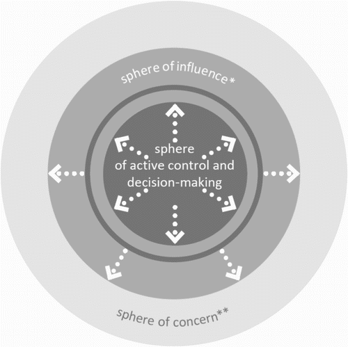
This descriptor lays emphasis on unifying, generally expansionary, evolution. BaltSeaPlan’s Vision 2030 takes ‘Pan-Baltic thinking’ as a fundamental principle by which the Baltic Sea is regarded as ‘ONE planning space and ecosystem’ (p. 18), transcending the complex partition of the sea by national maritime boundaries and underlying the collaborative, transnational approach to this MSP exercise. The sea basin is dramatically presented via satellite imagery (p. 4), emphasising the natural, semi-frozen, border-free whole to which humans (silhouetted in the image) are invited. It is expected that planners will consider this (ecosystem-defined) space as a whole, and that regional objectives will be set and transnational solutions sought (p. 3). ‘In the water there are no hard barriers, so that species, larvae, nutrients literally go with the flow’ (p. 12). Also, sea space is to be planned with the terrestrial hinterland in mind. This unbounded and expansive approach is expressed through specific topics, such as energy policy, where a number of pointers are suggested, including allocating space for offshore wind energy and a Super Grid for regional energy exchange (p. 28). To implement the vision, transboundary institutions are proposed with representatives from national planning authorities and other institutions and stakeholders (p. 4). Moreover, a graded and expansive interpretation of space-being-planned and spatial governance is expressed in radiating spheres of decision-making (); this implies that MSP has a core area of activity, both materially and institutionally, but also relates to wider contexts and seeks to extend its reach (p. 8). The EU language of territorial cohesion is called upon to underline the need for a multi-scalar approach (p. 15).
Figure 1. Spheres of decision-making in BaltSeaPlan (Gee et al., Citation2011, p. 8).
Teeming
This descriptor focuses on multiple centres of action, including the non-human and non-physical. The document set out a diverse range of natural and social elements as the focus of MSP, which are, to varying degrees, not simply passive objects but active agents in planning. This begins with ‘Baltic sea space’ itself as the key underlying component, almost personalised as ‘a valuable asset deserving our special attention’ (p. 2); it is self-contained and has characteristics that must be understood, including its geography, ecology and vulnerability to change. For example, its unusual brackish, shallow, sometimes icy conditions give rise to a unique flora and fauna. It is populated with features of economic activity and culture, such as offshore wind farms, ports, fisheries and employment opportunities (p. 6). Individuals also appear throughout the text through a series of quotations and images and a community of 30 ‘vision people’, including resident, scientist, planner (one actor alongside others), business developer and free horizon lover (p. 51). The human and non-human sit alongside each other with equal importance; the sustainability triangle is used as a balancing device, with political goals and environmental needs sharing in the planning process (p. 12). In addition, the expectation is that many of the features will be objectivised via data management; they will be mapped and allocated space, creating geometric shapes such as networks of marine protected areas, corridors for shipping and patches for offshore wind farms (pp. 13, 24f). There may be a differentiation of these areas, including priority, reservation, no go and open-use areas (p. 36). A further example of the teeming non-human population comes from the project’s wider actions, where environmental components are exhaustively catalogued, such as biotope types, natural scenery, climate, seabirds, bats and fish species (BaltSeaPlan, Citationonline).
Connecting
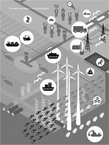
This stresses the formation of relations, including asymmetric ones, between centres of action. The vision sets out ‘connectivity thinking’ as a guiding principle, meaning that ‘planners connect the different elements of a system across space and time, such as shipping lanes and ports, or habitats and breeding areas, or the present situation and potential future change’ (p. 4). This begins with an understanding of the marine environment as interlinked elements: ‘everything is connected’ (p. 12); environmental health relies, for instance, on recognising migration routes and blue corridors for organisms, joining habitats and feeding grounds, possibly to help recovery of degraded habitats, This is in recognition of highly mobile, migratory species, and temporal variability, such as species which are vulnerable at certain stages of their life cycle (pp. 22, 27). For example, some of the commercially important fish species such as cod reproduce in areas distant from where they mature and feed. The project proposed protecting spawning and nursery areas from fishing activity so that stocks are not compromised (BaltSeaPlan, Citationonline). Physical connections extend to human activities, expressed in linear and nodal elements, such as shipping corridors defined by transport needs and hydrographic conditions, which join together ports, themselves linked to strong terrestrial hinterlands (pp. 22, 29). These connections have a transnational scale (reflecting other regional initiatives, such as European transport networks). They may assist in distributing benefits across the region, such as via grid connections, possibly with shipping, cables and pipelines incorporated into linear bundles (p. 28). The importance of this dimension is represented graphically () (p. 19). Institutional relations are promoted, with an emphasis on communication and cooperation at different spatial and administrative levels, including a transnational coordinating body for MSP (pp. 34, 40). The Baltic Sea itself is thought of as a connecting medium, materially and institutionally linking environmental, socio-cultural and economic goals (p. 13).
Figure 2. Connectivity thinking in BaltSeaPlan (Gee et al., Citation2011, p. 7).
Integrating
This descriptor points to the development of more complex eco-social and institutional networks. The document emphasises the integration of interconnecting elements in relation to both the physical environment and institutional working. Firstly, the complexity and sensitivity of the Baltic Sea are emphasised and a vision is presented of a healthy marine environment, ‘in which high biodiversity and dynamic natural processes sustain a resilient ecosystem’ (p. 27). For instance, blue corridors for fish are proposed ‘that ensure connectivity of habitats necessary for species survival’. These recognise the mobility of certain fish, for example, that migrate not just within the sea, but also along adjoining river systems (p. 31). Other elements of an ecosystem approach include measures for dealing with pollution and restoring degraded habitats (p. 27); a fundamental task is protecting the integrity of the ecosystem (p. 2). Secondly, MSP should promote joined-up, forward planning that moves away from sectoral planning (p. 8) and in which policy objectives across the sustainability spectrum are integrated (p. 13). Comprehensive planning frameworks should be developed, incorporating EU and regional legislation and policy (p. 34), so that ‘in 2030, a series of integrated transnational, national and sub-national maritime spatial plans has been drawn up’ (p. 36). This requires transnational processes so that ‘agreements have been reached on how to exchange information, what processes to use for drawing up joint plans (consultation, concertation, working together and the common elaboration of plans)’ (p. 40). Overall, an interacting, interwoven image of the planned sea is presented (). An example of this thinking in practice is a project study that assessed the possible effects of shipping noise on harbour porpoises; the concern was that underwater noise produced in a busy shipping lane would interfere with porpoises’ own use of sound to navigate and to locate prey (ultrasonic clicks and echoes), exploring the extent to which these different sounds can co-exist in the water column (BaltSeaPlan, Citationonline).
Re-configuring
Here, the emphasis is on constant re-formation of complexes. The vision acknowledges the likelihood of continuous change in the natural environment and human interaction, and in planning initiatives themselves. Much of this stems from the inherent mobility and dynamism of the sea, where, for example, ‘pollution and noise can travel freely’ (p. 12). Resource use is subject to this shifting environment, and activities such as fishing should ‘respond flexibly should there be any change’, such as reductions in stocks resulting from over-fishing or climate change (p. 30). Data should be collected to monitor changes, not just in the state of the marine environment, but also for socio-economic factors (p. 35). Equally, new activities will re-configure existing arrangements and may lead to wider adjustments; for instance, shipping lanes may be rearranged to accommodate other uses such as offshore wind farms and nature conservation (p. 29). Planning thus seeks to integrate aspects of this mutating assemblage; aggregating compatible uses is desirable in the interests of spatial efficiency (p. 20), such as by ‘placing aquaculture sites as co-use within already used areas such as wind farms’ (p. 31). It seeks to be responsive to wider sectoral and policy trends, such as the continuing growth in shipping and port development (p. 9). Overall, the vision itself is ‘not set in stone, but a living entity that can and should be revisited regularly’ (p. 9).
Anticipating
This suggests a readiness to respond to unforeseeable influences. Vision 2030, as its title suggests, is future-oriented, not simply in seeking to shape future patterns of sea use, but in being ready for changing and unpredictable circumstances. This begins with an awareness of the sea’s inherent sensitivity ‘to pollution, to climate change and to overuse’ (p. 12). The Baltic Sea, shallow, brackish, self-contained and with unique flora and fauna, is vulnerable to global influences. ‘Climate change is one example, leading to temperature change, salinity change or acidification in the Baltic Sea ecosystem’; economic demands and liberalisation and demographic change are also highlighted (p. 6). Sectoral growth pressures are already apparent, especially for offshore wind energy and maritime transport. For example, ‘investment in port infrastructure is planned as part of national strategies, such as deeper channels and landward cargo handling facilities’ (p. 9) and MSP should reflect these long-term objectives (p. 18). One response to anticipated needs is to make the most efficient use of space; concentrating activities will ‘keep back as much space as possible for future sea uses’ (p. 20). MSP is thus ‘a way of taking the initiative and expanding our thinking beyond the actual circumstances … allowing us to actively influence developments rather than wait for things to happen’ (p. 8). This includes allowing for the unpredictable: the future orientation means ‘living with uncertainty’, being ready to adopt ‘flexible, adaptive management’ and ‘learning by doing’ (pp. 42, 43). It is suggested, for example, that ‘management practices take into account the dynamic nature of the resource and respond flexibly’, such as by ‘offering alternatives for local fishermen who are requested to stop fishing for a certain period due to stock changes’ (p. 30). An example of anticipation from the project was an exercise in seabed and habitat mapping in an ecologically-important area of shallow water reefs. A number of ships have grounded here, and anticipating increasing levels of traffic over the coming years, the study sought out the most suitable corridor for dredging a deeper shipping channel. This involved acoustic sounding, video surveillance and diving, in order to sense the natural seabed features in detail (BaltSeaPlan, Citationonline).
Summary
All six aspects of the framework are echoed in the BaltSeaPlan vision. The sea itself is the flexing, ecosystem-defined, transnational core, taking into its ambit terrestrial hinterlands and with radiating spheres of institutional involvement and influence. Baltic space teems with bio-physical, socio-economic and cultural actants, the human and non-human intermingling and represented in object form. Connectivity is fundamental to their interaction, with natural interlinkages overlain by linear, distributing activities and cross-institutional relations. Actants have a tendency to complex integration, especially in ecosystem dynamics, but also in comprehensive, multi-objective approaches to planning. Assemblages are prone to constant re-configuration because of the sea’s liveliness and evolving economic and political objectives, that activities are contingent upon and planning should engage with. This underlies the anticipation of future change, as yet unknown but potentially far-reaching, that planning should make allowances for and be ready to respond to. In all, the document not only reinforces some of the norms of soft space thinking, such as expanding, cross-border circles of influence and web-like material structures and organisation, but also suggests that these norms are accentuated and added to through material fluidity, ecological dynamism, easy movement across borders, overwhelming dominance of the natural environment, interdependence between the natural and the human, predisposition to change and vulnerability to the unforeseen. This vision document is thus contributing in its turn to the Baltic Sea agenda, offering its living image of the sea and its occupants to governance of the region. This analysis echoes that of van Tatenhove (Citation2017) who interprets this MSP process as a reflexive governance arrangement by which rules of the game are changed and national discourses challenged.
Lively space, immersed planning
The notion of soft space provides a much-needed opportunity for MSP to engage with critical planning thought (Jay, Citation2010; Kidd & Ellis, Citation2012). Its perspectives resonate with the perception that marine realities call for more responsive planning approaches. The concept also opens the door to wider relational insights that confirm these intuitions and offer a fuller set of ideas to work with.
Exploring the development of MSP within these terms also suggests that MSP brings new insights to the soft space argument. Although soft space expresses greater degrees of flexibility in the geographical reach and institutional practices of planning, it does not adequately capture the sense of continual natural and human movement that MSP must deal with. The dynamic materiality of the sea itself and the contingency of substances, organisms and human activities upon it introduce a new level of interaction, energy and change to the sense of space-being-planned. This may be better described as lively space (Massey, Citation2005, p. 20), where time is breathed in, taking space from being understood as a static and momentary image to a moving and continually changing entity. The need for more active imagery is reinforced by the sense of making provisional decisions in uncertain and poorly understood settings, continually open to revision. The framework developed above can be read as a description of lively space as conceptualised through this engagement of MSP with spatial theory.
To understand space in this way, or rather to understand space as it is being constructed through planning in this way, is then to reconsider this formative planning action itself. The trend in planning thought, and to some extent practice, from technically-oriented attempts for achieving fixed goals to more communicative and shared approaches for addressing complex issues, is well-established. Planning may even be considered a process of co-evolution of actors and outcomes, of ‘undefined becoming’ in which the possibilities emerging from new connections are explored without predetermined ends (Boelens & de Roo, Citation2015). This understanding is in sympathy with the richly populated, interacting and ever-changing nature of lively space.
Importantly, this re-interpretation of planning immerses the practices of planning into the spatial ontology itself, dissolving the distinction between planning activity and the planned world; it repositions the institutions, people and techniques of planning as actants alongside others: part of, shaped by and shaping the heaving assemblage. Planning is thus about working from within, a process in which planning interacts with space-being-planned to the extent that planning actions seek to be enmeshed with spatial adjustments. A movement on the part of planning might have influence, and then planning be modified by that influence and by the continual self-initiating movements of the surrounding world. Planning would thus be engaged in a process of ongoing interplay with the liveliness of its medium, adjusting to the observed changes around it, those which are anticipated and unexpected, and also to the intended and unintended consequences of its own actions. This would involve validating actions with beneficial outcomes, drawing back or modifying where outcomes are not desirable, and being ready to respond, with agility, to surrounding movement and provocation.
In the marine realm, this perspective is given extra potency by the overwhelming natural environment. As the non-human is drawn explicitly into the endeavour of planning, not just as objects but as participants (Beauregard, Citation2015), the encompassing and powerful nature of the sea and its surroundings becomes not so much an additional challenge for planning as a leveller, demoting planning to a more modest and dependent role. Existing human knowledge, direct interaction with the sea and organisational arrangements already demonstrate a more tentative and compliant interlinkage with the materiality of the sea. MSP must find its place here, working within the constraints of limited understanding, institutional room for manoeuvre and options for action, recognising the given-ness of the setting with a massive physical and biological life of its own. Indeed, there are indications within MSP practice that the ‘greater human-environment complexity’ is raising an alternative voice to the rationalistic approaches that have so far prevailed (Boucquey, Fairbanks, St. Martin, Campbell, & McCay, Citation2016, p. 9).
It would run counter to this notion of the co-shaping and becoming of planning and its milieu to set out a pre-determined MSP process that would embody this understanding. Such an approach should be emergent, provisional and modifiable. However, I suggest that practice can be guided in this direction by questions that relate to generally accepted elements of MSP. These questions seek to sensitise the people involved in MSP to the sea’s liveliness and the contingency of their efforts upon this. For example:
How might plan areas be defined with flexibility to accommodate shifting conditions and priorities?
How can the planning process stay open to new issues and entrants as they arise?
How can advocates of the non-human be involved in the planning process?
How can data and information be gathered to represent expansive, mobile and changeable conditions and activities?
How are the plan’s main issues and concerns evolving in association with each other?
How might interactions that are adjusting with time be represented?
How might the plan’s content remain open to unforeseen circumstances?
There is scope here for a fuller reflexive framework that may help MSP practice yield to the inherent fluidity of the sea, taking this as constitutive of its own processes, and that is itself, of course, under constant review.
Ingold (Citation2008) draws attention to the weather as an inhabited medium made up of fluxes rather than solid substances, and suggests that human existence is best thought of in similar terms, as lived along lines rather than as located in places; we are multiple paths of flow, immersed in a world of flow. Similarly, Hillier suggests that planning can be conceptualised as a process of navigation, following lines of possibilities: ‘It evolves, it functions, it adapts … concerned with what can be done’ (Citation2010, p. 454); she then proposes methods of tracing out chosen relations and charting preferred directions. The six descriptors of the framework presented here, whilst not intended to be definitive, may also provoke reflection and inspiration when embarking on and designing MSP processes. There is here the potential for a fuller sensory, cognitive and institutional engagement with the realities of marine space-being-planned on the part of those engaged in MSP.
Disclosure statement
No potential conflict of interest was reported by the author.
Notes on contributor
Stephen Jay (BSc, MA, PhD, MRTPI) is a senior lecturer at the University of Liverpool in the UK, where he specialises in teaching and research on marine spatial planning. He is particularly interested in the intechange between spatial theory and marine planning practice. He directs a postgraduate course on marine planning and has researched and published widely on the topic, including contributing to and leading European funded projects. He is also co-founder of the MSP Research Network, which brings together researchers, practitioners and policy-makers across Europe to take forward MSP research and practice.
Notes
1 Marine spatial planning is the most widely recognised term, though it is variously referred to as maritime spatial planning, marine planning, coastal and marine spatial planning, ocean planning etc.
References
- Albrechts, L. (2006). Shifts in strategic spatial planning? Some evidence from Europe and Australia. Environment and Planning A, 38, 1149–1170. doi: 10.1068/a37304
- Allmendinger, P., Chilla, T., & Sieler, F. (2014). Europeanizing territoriality: Towards soft spaces? Environment and Planning A, 46, 2703–2717. doi: 10.1068/a130037p
- Allmendinger, P., & Haughton, G. (2007). The fluid scales and scope of UK spatial planning. Environment and Planning A, 39, 1478–1496. doi: 10.1068/a38230
- Allmendinger, P., & Haughton, G. (2009a). Critical reflections on spatial planning. Environment and Planning A, 41, 2544–2549. doi: 10.1068/a42227
- Allmendinger, P., & Haughton, G. (2009b). Soft spaces, fuzzy boundaries, and metagovernance. Environment and Planning A, 41, 617–633. doi: 10.1068/a40208
- Allmendinger, P., & Haughton, G. (2010). Spatial planning, devolution, and new planning spaces. Environment and Planning C: Government and Policy, 28, 803–818. doi: 10.1068/c09163
- Allmendinger, P., & Haughton, G. (2014). Alternative planning spaces. In I. Deas, & S. Hincks (Eds.), Alternative paths to territorial policy and governance (pp. 73–91). London: Routledge.
- Allmendinger, P., Haughton, G., Knieling, J., & Othengrafen, F., (Eds.) (2015). Soft spaces in Europe: Re-negotiating governance, boundaries and borders. London: Routledge, 248pp.
- Amin, A. (2002). Spatialities of globalisation. Environment and Planning A, 34, 385–399. doi: 10.1068/a3439
- Amin, A. (2015). Animated space. Public Culture, 27(2), 239–258. doi: 10.1215/08992363-2841844
- Amin, A., & Thrift, N. (2002). Cities: Reimagining the urban. Cambridge: Polity Press.
- Anderson, J., & Peters, K. (Eds.) (2014). Water worlds: Human geographies of the ocean. London: Routledge, 196pp.
- Backer, H. (2011). Transboundary maritime spatial planning: A Baltic Sea perspective. Journal of Coastal Conservation, 15(2), 279–289. doi: 10.1007/s11852-011-0156-1
- BaltSeaPlan. (online). Planning the Future of the Baltic Sea. Retrieved from http://baltseaplan.eu
- Bear, C. (2013). Assembling the sea: Materiality, movement and regulatory practices in the Cardigan Bay scallop fishery. Cultural Geographies, 20(1), 21–41. doi: 10.1177/1474474012463665
- Beauregard, R. (2015). Planning matter: Acting with things. Chicago: University of Chicago Press.
- Boelens, L., & de Roo, G. (2015). Planning of undefined becoming: First encounters of planners beyond the plan. Planning Theory, 15(1), 42–67. doi: 10.1177/1473095214542631
- Boucquey, N., Fairbanks, L., St. Martin, K., Campbell, L., & McCay, B. (2016). The ontological politics of marine spatial planning: Assembling the ocean and shaping the capacities of ‘community’ and ‘environment’. Geoforum; Journal of Physical, Human, and Regional Geosciences, 75, 1–11.
- Brennan, J., Fitzsimmons, C., Gray, T., & Raggatt, L. (2014). EU marine strategy framework directive and marine spatial planning. Marine Policy, 43, 359–366. doi: 10.1016/j.marpol.2013.07.011
- Calado, H., Ng, K., Johnson, D., Sousa, L., Phillips, M., & Alves, F. (2010). Marine spatial planning: Lessons learned from the Portuguese debate. Marine Policy, 34, 1341–1349. doi: 10.1016/j.marpol.2010.06.007
- Claydon, J. (2006). Marine spatial planning: A new opportunity for planners. Town Planning Review, 77(2), i–vi. doi: 10.3828/tpr.77.2.1
- Commission of the European Communities (CEC). (2008). Roadmap for Maritime Spatial Planning, COM 791. Brussels: Author.
- Commission of the European Communities (CEC). (2009). European Union Strategy for the Baltic Sea Region, COM 248. Brussels: Author.
- Conley, V. (1997). Ecopolitics: The environment in poststructuralist thought. London: Routledge.
- Courtney, E., & Wiggin, J. (2003). Ocean Zoning for the Gulf of Maine. unpublished document.
- Crowder, L., & Norse, E. (2008). Essential ecological insights for marine ecosystem-based management and marine spatial planning. Marine Policy, 32(5), 772–778. doi: 10.1016/j.marpol.2008.03.012
- The Crown Estate. (online). The Crown Estate. Retrieved from https://www.thecrownestate.co.uk/
- Cullingworth, B., Nadin, V., Hart, T., Davoudi, S., Pendlebury, J., Vigar, G., … Townshend, T. (2015). Town and country planning in the UK (15th ed.). London: Routledge.
- Davoudi, S., & Strange, I. (Eds.) (2009). Conceptions of space and place in strategic spatial planning. London: Routledge.
- Deas, I., Haughton, G., & Hincks, S. (2015). The Atlantic gateway and evolving spatial imaginaries in North West England. In P. Allmendinger, G. Haughton, J. Knieling, & F. Othengrafen (Eds.), Soft spaces in Europe: Re-negotiating governance, boundaries and borders (pp. 25–44). London: Routledge.
- Dembski, S. (2015). Structure and imagination of changing cities: Manchester, Liverpool and the spatial in-between. Urban Studies, 52(9), 1647–1664. doi: 10.1177/0042098014539021
- Department for Environment, Food & Rural Affairs (Defra). (2006). A Marine Bill, consultation document. London: Defra.
- Department for Environment, Food & Rural Affairs (Defra). (2007). A Sea Change: A Marine Bill White Paper, Cm 7047. London: Author.
- Department for Environment, Food & Rural Affairs (Defra). (2009). Consultation on marine plan areas within the English Inshore and English offshore marine regions. London: Author.
- Department for Environment, Food & Rural Affairs (Defra). (2011). A description of the marine planning system for England. London: Author.
- Douvere, F. (2008). The importance of marine spatial planning in advancing ecosystem-based sea use management. Marine Policy, 32(5), 762–771. doi: 10.1016/j.marpol.2008.03.021
- Douvere, F., & Ehler, C. (2009). New perspectives on sea use management: Initial findings from European experience with marine spatial planning. Journal of Environmental Management, 90(1), 77–88. doi: 10.1016/j.jenvman.2008.07.004
- Ehler, C., & Douvere, F. (2007). Visions for a sea change. Paris: UNESCO.
- Ehler, C., & Douvere, F. (2009). Marine spatial planning: A step-by-step approach toward ecosystem-based management. Paris: UNESCO.
- English Nature. (2003). Review of how the land use planning system could influence the development of a marine spatial planning system for England. Peterborough: English Nature.
- European Commission (EC). (online). Maritime spatial planning. Retrieved from http://ec.europa.eu/maritimeaffairs/policy/maritime_spatial_planning/index_en.htm
- European Parliament & Council (EPC). (2014). Directive 2014/89/EU of the European Parliament and of the Council Establishing a Framework for Maritime Spatial Planning, Official Journal of the European Union, L 257, 135–145.
- Faludi, A. (2010). Cohesion, coherence, cooperation: European spatial planning coming of age? London: Routledge.
- Faludi, A. (2013). Territorial cohesion, territorialism, territoriality and soft planning: A critical review. Environment & Planning A, 45, 1302–1317. doi: 10.1068/a45299
- Flannery, W., & Ó Cinnéide, M. (2012). A roadmap for marine spatial planning: A critical examination of the European Commission’s guiding principles. Marine Policy, 36, 265–271. doi: 10.1016/j.marpol.2011.06.003
- Flannery, W., O’Hagan, A. M., O’Mahony, C., Ritchie, H., & Twomey, S. (2015). Evaluating conditions for transboundary Marine Spatial Planning: Challenges and opportunities on the island of Ireland. Marine Policy, 51, 86–95. doi: 10.1016/j.marpol.2014.07.021
- Frazão Santos, C., Domingos, T., Ferreira, M. A., Orbach, M., & Andrade, F. (2014). How sustainable is sustainable marine spatial planning? The Portuguese experience. Marine Policy, 49, 59–65. doi: 10.1016/j.marpol.2014.04.004
- Friedmann, J. (1993). Towards a non-Euclidean mode of planning. Journal of the American Planning Association, 59(3), 482–484. doi: 10.1080/01944369308975902
- Friedmann, J. (2004). Strategic spatial planning and the longer range. Planning Theory & Practice, 5(1), 49–67. doi: 10.1080/1464935042000185062
- Gee, K., Kannen, A., & Heinrichs, B. (2011). Baltseaplan vision 2030: Towards the sustainable planning of Baltic Sea Space. Hamburg: BaltSeaPlan.
- Gilliland, P., & Laffoley, D. (2008). Key elements and steps in the process of developing ecosystem-based marine spatial planning. Marine Policy, 32(5), 787–796. doi: 10.1016/j.marpol.2008.03.022
- Gopnik, M., Fieseler, C., Cantral, L., McClellan, K., Pendleton, L., & Crowder, L. (2012). Coming to the table: Early stakeholder engagement in marine spatial planning. Marine Policy, 36, 1139–1149. doi: 10.1016/j.marpol.2012.02.012
- Graham, S., & Healey, P. (1999). Relational concepts of space and place: Issues for planning theory and practice. European Planning Studies, 7(5), 623–646. doi: 10.1080/09654319908720542
- Graham, S., & Marvin, S. (2001). Splintering urbanism: Networked infrastructures, technological mobilities and the urban condition. London: Routledge.
- Hassan, D., Kuokkanen, T., & Soininen, N. (Eds.). (2015). Transboundary maritime spatial planning: A legal perspective. London: Earthscan.
- Haughton, G., & Allmendinger, P. (2015). Fluid spatial imaginaries: Evolving estuarial city-regional spaces. International Journal of Urban and Regional Research, 39(5), 857–873. doi: 10.1111/1468-2427.12211
- Haughton, G., Allmendinger, P., Counsell, D., & Vigar, G. (2010). The New spatial planning: Territorial management with soft spaces and fuzzy boundaries. London: Routledge.
- Healey, P. (2004). The treatment of space and place in the new strategic spatial planning in Europe. International Journal of Urban and Regional Research, 28(1), 45–67. doi: 10.1111/j.0309-1317.2004.00502.x
- Healey, P. (2007). Urban complexity and spatial strategies: Towards a relational planning for our times. London: Routledge.
- Hillier, J. (2007). Stretching beyond the horizon: A multiplanar theory of spatial planning and governance. Aldershot: Ashgate.
- Hillier, J. (2010). Strategic navigation in an ocean of theoretical and practice complexity. In J. Hillier, & P. Healey (Eds.), The Ashgate research companion to planning theory (pp. 447–480). Aldershot: Ashgate.
- Hull, A. (2013). Managing competition for marine space using the tools of planning in the UK. Planning Practice & Research, 28(5), 503–526. doi: 10.1080/02697459.2013.812375
- Ingold, T. (2008). Bindings against boundaries; entanglements of life in an open world. Environment & Planning A, 40, 1796–1810. doi: 10.1068/a40156
- Janssen, H., Kidd, S., & Kvinge, T. (2013). A spatial typology for the sea: A contribution from the Baltic. Marine Policy, 42, 190–197. doi: 10.1016/j.marpol.2013.03.001
- Jay, S. (2010). Built at Sea: Marine management and the construction of marine spatial planning. Town Planning Review, 81(2), 173–192. doi: 10.3828/tpr.2009.33
- Jay, S. (2012). Marine space: Manoeuvring towards a relational understanding. Journal of Environmental Policy and Planning, 14(1), 81–96. doi: 10.1080/1523908X.2012.662383
- Jay, S. (2013). From disunited sectors to disjointed segments? Questioning the functional zoning of the seas. Planning Theory and Practice, 14(4), 509–525. doi: 10.1080/14649357.2013.848291
- Jay, S. (2015). Transboundary maritime spatial planning in the Irish Sea. In D. Hassan, T. Kuokkanen, & N. Soininen (Eds.), Transboundary maritime spatial planning: A legal perspective (pp. 174–188). London: Earthscan.
- Jay, S., Flannery, W., Vince, J, Liu, W, Xue, J. G, Matczak, M … Dean, H. (2013). International progress in marine spatial planning. In A. Chircop, S. Coffen-Smout, & M. McConnell (Eds.), Ocean yearbook (Vol. 27, pp. 171–212). Leiden: Martinus Nijhoff.
- Jones, P., Lieberknecht, L., & Qiu, W. (2016). Marine spatial planning in reality. Marine Policy, 71, 256–264. doi: 10.1016/j.marpol.2016.04.026
- Kelly, C., Gray, L., Shucksmith, R., & Tweddle, J. (2014). Review and evaluation of marine spatial planning in the Shetland Islands. Marine Policy, 46, 152–160. doi: 10.1016/j.marpol.2014.01.017
- Kerr, S., Johnson, K., & Side, J. C. (2014). Planning at the edge: Integrating across the land sea divide. Marine Policy, 47, 118–125. doi: 10.1016/j.marpol.2014.01.023
- Kidd, S., & Ellis, G. (2012). From the land to sea and back again? Using terrestrial planning to understand the process of marine spatial planning. Journal of Environmental Policy and Planning, 14(1), 49–66. doi: 10.1080/1523908X.2012.662382
- Knol, M. (2011). Mapping ocean governance: From ecological values to policy instrumentation. Journal of Environmental Planning and Management, 54(7), 979–995. doi: 10.1080/09640568.2010.547686
- Lefebvre, H. (1991). The production of space. Oxford: Blackwell.
- Lehman, J. (2013). Relating to the sea: Enlivening the ocean as an actor in Eastern Sri Lanka. Environment and Planning D: Society and Space, 31, 485–501. doi: 10.1068/d24010
- Lovelock, J. (1987). Gaia: A new look at life on earth. Oxford: Oxford University Press. 157pp.
- Massey, D. (2005). For space. London: Sage.
- May, T. (2011). Social research: Issues, methods and process (4th ed.). Buckingham: Open University Press. 332pp.
- Metzger, J., & Schmitt, P. (2012). When soft spaces harden: The EU strategy for the Baltic Sea Region. Environment and Planning A, 44, 263–280. doi: 10.1068/a44188
- MSPP Consortium. (2006). Marine Spatial Planning Pilot: Final Report, unpublished document.
- Murdoch, J. (2006). Post-structuralist geography: A guide to relational space. London: Sage.
- NIRAS (2017). Cross-border cooperation in maritime spatial planning. Brussels: European Commission, 110 pp.
- Odum, H. T. (1983). Systems ecology: An introduction. New York: Wiley. 644pp.
- Olesen, K. (2012). Soft spaces as vehicles for neoliberal transformations of strategic spatial planning? Environment and Planning C: Government and Policy, 30, 910–923. doi: 10.1068/c11241
- Purkarthofer, E. (2016). When soft planning and hard planning meet. European Journal of Spatial Development, 61, online.
- Qiu, W., & Jones, P. (2013). The emerging policy landscape for marine spatial planning in Europe. Marine Policy, 39, 182–190. doi: 10.1016/j.marpol.2012.10.010
- Rosen, F., & Olsson, P. (2013). Institutional entrepreneurs, global networks, and the emergence of international institutions for ecosystem-based management: the Coral Triangle initiative. Marine Policy, 38, 195–204. doi: 10.1016/j.marpol.2012.05.036
- Royal Town Planning Institute (RTPI). (2007). The Marine White Paper: A Consultation Response by the RTPI, unpublished document.
- Russ, G., & Zeller, D. (2003). From Mare Liberum to Mare Reservarum. Marine Policy, 27(1), 75–78. doi: 10.1016/S0308-597X(02)00054-4
- Rydin, Y., & Tate, L. (Eds.) (2016). Actor networks of planning: Exploring the influence of actor network theory. London: Routledge, 249pp.
- Sartorio, F. S. (2005). Strategic spatial planning: A historical review of approaches, its recent revival, and an overview of the state of the art in Italy. disP - The Planning Review, 162, 26–40. doi: 10.1080/02513625.2005.10556930
- Stead, D. (2013). European integration and spatial rescaling in the Baltic Region: Soft spaces, soft planning and soft security. European Planning Studies, 22(4), 680–693. doi: 10.1080/09654313.2013.772731
- Stead, D. (2013). European integration and spatial rescaling in the Baltic Region: soft spaces, soft planning and soft security. European Planning Studies, 22(4), 680–693. doi: 10.1080/09654313.2013.772731
- Steinberg, P., & Peters, K. (2015). Wet ontologies, fluid spaces: Giving depth to volume through oceanic thinking. Environment and Planning D, 33, 247–264. doi: 10.1068/d14148p
- Suárez de Vivero, J. L. (2007). The European vision for oceans and seas. Marine Policy, 31(4), 409–414. doi: 10.1016/j.marpol.2006.10.005
- Tafon, R. (2017). Taking power to sea: Towards a post-structuralist discourse theoretical critique of marine spatial planning. Environment and Planning C: Politics and Space, 1–16.
- Tanaka, Y. (2015). The international Law of the Sea (2nd ed.). Cambridge: Cambridge Press. 548pp.
- Tewdwr-Jones, M., Gallent, N., & Morphet, J. (2010). An anatomy of spatial planning: Coming to terms with the spatial element in UK planning. European Planning Studies, 18(2), 239–257. doi: 10.1080/09654310903491572
- Thiel, A. (2013). Scalar reorganisation of marine governance in Europe. Marine Policy, 39, 322–332. doi: 10.1016/j.marpol.2012.11.002
- Tyldesley, D. (2004). Making the Case for Marine Spatial Planning in Scotland, unpublished document.
- UNEP & GEF-STAP. (2014). Marine spatial planning in practice: Transitioning from planning to implementation. Nairobi: UNEP.
- UNESCO. (online). Marine Spatial Planning Programme. Retrieved from http://msp.ioc-unesco.org/
- United Nations Environment Programme (UNEP). (2006). Marine and coastal ecosystems and human wellbeing. Naiobi: Author, 76pp.
- van Schaick, J., & Klaasen, I. (2011). The Dutch layers approach to spatial planning and design. European Planning Studies, 19(10), 1775–1796. doi: 10.1080/09654313.2011.614387
- van Tatenhove, J. (2017). Transboundary marine spatial planning: A reflexive marine governance experiment? Journal of Environmental Policy & Planning, in press.
- Vincent, M. A, Atkins, S. M, Lumb, C. M, Golding, N, Lieberknecht, L. M, & Webster, M. (2004). Marine Nature Conservation and Sustainable Development: The Irish Sea Pilot, Report to Defra, Joint Nature Conservation Committee. Peterborough.
- Zaucha, J. (2014). Sea basin maritime spatial planning: A case study of the Baltic Sea region and Poland. Marine Policy, 50, 34–45. doi: 10.1016/j.marpol.2014.05.003