Abstract
This study aims to evaluate different methods of integrating optical and multipolarized radar data for land use and land cover (LULC) mapping in an agricultural frontier region in the Central Brazilian Amazon, which requires continuous monitoring due to the increasing human intervention. The evaluation is performed using different sets of fused and combined data. This article also proposes to apply the principal component (PC) technique to the multipolarized synthetic aperture radar (SAR), prior to the optical and radar data PC fusion process, aiming at the use of all available polarized information in the fusion process. Although the fused images improve the visual interpretation of the land use classes, the best results are achieved with the simple combination of the Advanced Land Observing Satellite (ALOS)/phased array L-Band SAR (PALSAR) with the LANDSAT5/Thematic Mapper (TM) images. Radar information is found to be particularly useful for improving the user accuracies (UAs) of Soybean with 40 days after seeding (an increase of about 55%), Dirty Pasture (22%), Degraded Forest and Regeneration (5%), and the producer accuracies (PAs) of Clean Pasture (39%), Fallow Agriculture (16%), Degraded Forest and Regeneration (3%), and Primary Forest (2%). Information from the HH (horizontal transmit and horizontal receive) polarization contributes more than that from HV (horizontal transmit and vertical receive) polarization to discriminate the classes, although the use of both polarizations produces results that are statistically better than those obtained with a single polarization.
Introduction
Images acquired by remote sensing have great potential to provide information about different environmental variables because it is possible to use different sensors to record the electromagnetic radiation reflected or emitted by the terrestrial objects at different spatial, spectral, radiometric, and temporal resolutions. Furthermore, these images provide a synoptic and repetitive view of ground targets (Huang et al. Citation2010). These data have been widely used for mapping and monitoring ecosystems and land resources. Accurate mapping of the land use and land cover (LULC) classes provides the basis for many applications and research subjects, such as environmental analysis and modeling (Laurila et al. Citation2010), global and regional climate change (Renzullo et al. Citation2008), and multitemporal analysis (Mcnairn et al. Citation2009), among others. Therefore, as the result of several efforts, progress has been made in improving the methods for extracting information from different data types to increase the discriminability of the classes and, consequently, the accuracy of the LULC mapping (Dutra et al. Citation2002; Lu, Batistella, and Moran Citation2007; Santos and Messina Citation2008; Ban, Hu, and Rangel Citation2010; Walker et al. Citation2010), leading to better classification results.
Under many circumstances, the use of a single type of sensor (optical or radar) does not provide sufficient information about the phenomena and/or objects under study. Optical data are related to the chemical, physical, and biological characteristics of the targets, whereas radar data are associated with the shape, texture, structure, and dielectric properties. These data are complementary; thus, the integration of these data can result in improvements in the information extracted from the imaged targets and, consequently, in a better classification accuracy of the features of interest (Huang et al. Citation2010). In this article, it is considered that the data integration can be performed by combination (band stacking) or by fusion techniques.
In recent years, there have been significant advancements in the techniques for fusing synthetic aperture radar (SAR) with optical data, which have improved the classification of the features of interest (Lu, Batistella, and Moran Citation2007; Dong et al. Citation2009; Huang et al. Citation2010; Silva et al. Citation2011). However, there is no consensus within the scientific community regarding the best method to integrate optical and SAR data for classification purposes, especially in the areas of tropical rainforest, such as those located in the Brazilian Amazon region. Some authors, including Dutra et al. (Citation2002), Lu, Batistella, and Moran (Citation2007), Santos and Messina (Citation2008), Lu et al. (Citation2011), Rodrigues and Souza-Filho (Citation2011), and Silva et al. (Citation2011), address the fusion using different data from the Amazon region, and they indicate that the information extracted from the integrated data can be advantageous for the LULC classification in the Amazon region. However, there are few studies that are focused on identifying the most suitable method for integrating optical and SAR data in this region.
In addition to being generated at different frequencies, SAR images can be processed using different polarizations. This type of image, called a multipolarized image, provides information in various polarizations, which aids in the discrimination of LULC classes. Some studies, such as those by Walker et al. (Citation2007), Waske and Benediktsson (Citation2007), Waske and Linden (Citation2008), Mcnairn et al. (Citation2009), Wijaya and Gloaguen (Citation2009), Huang et al. (Citation2010), Laurila et al. (Citation2010), Lu et al. (Citation2011), Pouteau and Stoll (Citation2011), and Walker et al. (Citation2011), perform fusion or combination of optical data with multipolarized SAR images. Among these works, only Lu et al. (Citation2011) and Walker et al. (Citation2011) address this issue in the Amazon region.
The study area of the present study is located in the eastern region of the Central Amazon, near the city of Santarém. This region is characterized by the processes of land use and cover changes that have intensified in recent years due to the expansion of mechanized agriculture (soybeans and rice), leading to areas with considerable complexity, which is an inherent characteristic of agricultural expansion areas. Such transformations include the expropriation of the land occupied by small-scale farms and the creation of several new settlements in the area.
Although the work by Lu et al. (Citation2011) also addresses the issue of land use mapping by the fusion of optical and multipolarized SAR data in areas located in the eastern part of the Central Amazon, specifically in Altamira city, the two areas of study are considerably different. In contrast to the Santarém region, the Altamira region is no longer treated as an agricultural frontier area because it is considered one of the large centers of grain production and livestock and, thus, has a spatial pattern of the LULC that is very different from that observed in Santarém. In this context, the forms of integrating SAR and optical data may also be different, which emphasizes the need to carefully test and explore the different fusion methods. Another difference between the fusion methods used in this work and those proposed by Lu et al. (Citation2011) is that the former enables the integration of more than two radar polarizations and simultaneously reduces the dimensionality of the data, which is not possible in the latter.
The objective of the present article is to quantitatively and qualitatively (visually) evaluate different methods of integrating optical and multipolarized SAR data, aiming at LULC mapping in a complex environmental region located in the Brazilian Amazon. For this purpose, data from LANDSAT5/Thematic Mapper (TM) (six original bands) and the Advanced Land Observing Satellite (ALOS)/phased array L-Band SAR (PALSAR) (HH (horizontal transmit and horizontal receive) and HV (horizontal transmit and vertical receive) polarizations) sensors are used. These images are referred to TM and PALSAR images, respectively, throughout the remainder of this article. These images are integrated using a simple combination of bands or with the fusion method of principal components (PCs). These images integration procedures are evaluated through the classification results using the maximum likelihood (ML) classifier followed by the iterated conditional modes (ICM) classifier (Frery, Freitas, and Correia Citation2007), an approach hereafter referred to as ML/ICM. The issue of identifying the most useful polarization for the discrimination of each land cover class is also addressed in this work.
Materials and methods
The selected study area covers a portion of the municipality of Belterra in the Brazilian state of Pará, which is located in the eastern region of the Central Amazon between 55º 1′51″ W 3º 22′ 51″ S and 54º 42′ 15″ W 2º 56′ 53″ S, with an area of approximately 1139 km2 (). The area is characterized by a hot and humid climate and a predominance of tropical rainforest. There are areas of degraded forest (mainly due to burning) and areas at different stages of secondary succession or deforestation as a result of human actions near the BR-163 highway. Agriculture and livestock farming are the economic activities of the region. These activities increase the complexity of the LULC in the region, which include pasture and agricultural areas, with the latter primarily characterized by the production of soybeans and other grains, such as rice, maize, sorghum, and beans. The agricultural calendar begins in December, at the beginning of the rainy season, with one or two plantings per year. The harvests related to these plantings are in March/April and July/August, respectively (Escada et al. Citation2009).
Figure 1. The location of the study area: (a) TM and (b) PALSAR images.
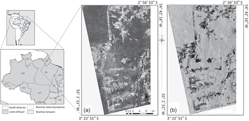
The optical data used in this work are from a multispectral TM image with 1–5 and 7 bands, 8 bits, acquired on 29 June 2010 with 30 m of spatial resolution. The radar data are from an L-band amplitude of fine beam dual (FBD) PALSAR image, HH and HV polarizations, level 1.5, with 4 looks, 12.5 m of pixel spacing, and 16 bits, acquired on 21 June 2010 in geo-coded format. These images are also shown in .
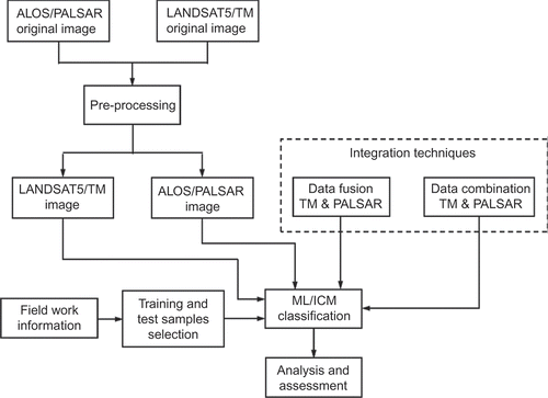
Initially, the data were pre-processed, and training and validation samples were collected. After this step, the PALSAR and TM data were fused using different sets of attributes. Based on the ML/ICM algorithm, several classifications were performed using the resulting fused images and the combination of bands. Finally, a visual analysis of the fused images and a quantitative evaluation of the classifications resulting from the fusion and combinations of images were performed. A flowchart illustrating this methodology is shown in , and each step is detailed in the remainder of this section.
Figure 2. A flowchart of the methodology.
Pre-processing
All combination and fusion methods assume that the SAR and optical images are on the same projection and geographic coordinate system and that they are co-registered at a subpixel level (Chavez, Sides, and Anderson Citation1991). The SAR image was used as the basis for the co-registration process, which had a residual mean square error of 0.61. During this process, the TM image was re-sampled to the same pixel spacing of the PALSAR data, while the radiometric resolution of optical and SAR images was maintained in 8 and 16 bits, respectively.
In this study, the enhanced Lee adaptive filter with a 3 × 3 moving window was used for noise reduction before the integration processes. This filter was selected based on its ability to reduce speckle noise while preserving edge information, textures, linear structures, and the average backscatter, especially in homogeneous areas. The window size of 3 × 3 was selected to reduce speckle noise, thereby losing little spatial resolution.
Data integration
Data combination
The integration of images from different sensors can be performed using several methods. The easiest method to integrate the images is to stack them together before analyzing or classifying them. Here, this band-stacking process is referred to as image combination. Three sets of images were generated by combining the six TM bands with (a) HH; (b) HV; and (c) HH and HV PALSAR polarizations. The two first sets contain seven bands (one SAR and six TM bands), whereas the last set has eight bands (two SAR and six TM bands).
Data fusion analysis and visual interpretation
Among the currently used methods of data fusion for integrating information from different sensors, the most frequently used are intensity, hue and saturation (IHS), Brovey transformation (BT), PCs, and wavelet transform (Zhang Citation2004; Cakir and Khorram Citation2008; Dong et al. Citation2009; Zhang Citation2010).
The PC method was initially developed to support research and image processing with numerous data to reduce the dimensionality of the data or in the variable selection procedure. This method was later applied to the fusion of optical and SAR data. The major advantage of the PC fusion method over other traditional fusion methods (IHS and BT) is the possibility of integrating more than four bands; therefore, this method is one of the most efficient fusion techniques when working with large amounts of data (Dong et al. Citation2009; Zhang Citation2004). This advantage was the primary reason that the PC fusion method was used in the present work.
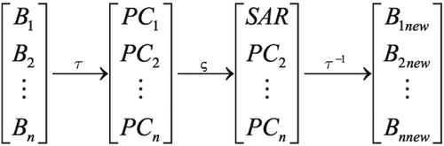
PC fusion integrates SAR with optical data by replacing one of the PCs generated from the optical data with SAR data, and then applying the inverse PC transformation. exemplifies this integration, where B 1,…, Bn represent n optical bands; τ represents the forward PC transformation; ς is the process of replacing one of the PCj (j = 1,…,n) with SAR data; and τ−1 is the inverse PC transformation. This process generates a fused image (B 1 new ,…, Bnnew ) with the same number of bands of the original TM image with the advantage of having information of both images (SAR and TM). Some authors, including Lu, Batistella, and Moran (Citation2007), replace the components containing more information, such as the PC 1, with the SAR data. Other authors, including Torrion (Citation2002), replace the PC containing less information. In general, the PC fusion method only uses one radar band when replacing a PC of optical data. Because the PALSAR image is multipolarized, this article proposes, in addition to using the individual radar bands, to apply the forward PC transformation to the multipolarized SAR image, employing its first PC (denominated by PC 1 (HH&HV)) to replace PC 1 or PC 2 of the optical data. This procedure aims to use a larger amount of information in the data fusion process.
Figure 3. The fusion of SAR and optical images using the PC technique.
For a correct application of the fusion method using PC, it is necessary to standardize the SAR bands or the first PC extracted from them with respect to the energy levels of the PC from the optical data to be replaced. This standardization, described by EquationEquation (1), is required to maintain the original energy balance after executing the inverse transformation:
The PC transformations were performed using the correlation matrix to normalize the data and, thus, to cause less distortion in the balance of energy. The eigenvalues analysis indicated that the two first components contain 93.36% of the total variance of the original images. During the fusion process, the SAR information was replaced only on the components with a higher percentage of information, i.e. PC 1 or PC 2. Because the SAR information is contained in the individual radar polarization (HH or HV) or in PC 1 (HH&HV), six different fusion image sets can be generated.
The fusion of optical with SAR images is commonly used to improve the visual interpretation of the images and the features of interest. Usually, three bands resulting from the fusion are selected according to the objective of the study and visualized in Red-Green-Blue (RGB) space. In this article, for each of the fused image sets, three bands were identified such that, when composed in the RGB space, they provided the best visualization and discrimination of the features of interest. These compositions were visually compared and also compared with the composition of three bands from the TM image. Because each image set (TM or fused) has six bands, it is possible to generate a total of 20 different combinations of three bands for each image set. As seven sets are available (one TM and six fused images), a total of 140 subsets of three bands can be formed, which makes a visual comparison among them difficult. Therefore, for each set, the best combination was determined based on the optimal index factor (OIF). This index was developed by Chavez, Berlin, and Sowers (Citation1982) and is expressed as
Training and validation sample selection
Because the classifier used in this work is the ML/ICM-supervised classifier, samples were selected for training the classifier and for the validation of the classified image. These samples consisted of two different sets and are referred to as the training and validation samples, respectively.
To guarantee that the samples represented homogeneous areas in the TM and PALSAR images, a segmentation of each image was performed. The segmentation of the PALSAR image was performed using the SegSAR algorithm (Sousa Citation2005), which is an algorithm specifically developed for the segmentation of SAR images (https://sites.google.com/site/segsar2/home). The TM image was segmented using an edge-based segmentation algorithm (Xiaoying Citation2009). These two segmented images were merged in a final image, which was used for selecting the training and validation samples.
For the definition of the LULC classes and for the selection of training and validation samples, the following data were used: PALSAR and TM images; the merged segmentation of these images; and a database containing photos, geographic location, and comments about the visited areas during the fieldwork conducted in May and September 2010. Based on the analysis of these data sets, the following classes of LULC were defined: Primary Forest (PF), Degraded Forest (DF), Intermediate Regeneration (IR), Old Regeneration (OR), New Regeneration (NR), Dirty Pasture (DP), Clean Pasture (CP), Fallow Agriculture (FA), Soybean40 (S40), and Soybean100 (S100). A brief description of these classes is provided in the second column of . After a detailed exploratory data analysis, the classes DF, OR, and IR were grouped into a single class (DF + OR + IR) because there was no discrimination among them. Therefore, eight LULC classes are used in the following analysis.
1 Descriptions of the land use and land cover classes and number of pixels of the training and validation samples.
The selected samples of each class consisted of regions of the segmented image, in which a morphological erosion filter (Haralick, Sternberg, and Zhuang Citation1987) was applied such that the boundaries of the regions could not influence the classification results. After these procedures, a statistical analysis of the data spatial autocorrelations was carried out, and the results showed that these autocorrelations are statistically zero for lags (distance) greater than or equal to three pixels, in both directions. Therefore, the samples for all classes were decorrelated by sampling every three pixels in both directions. The numbers of pixels that were used for training the classifier and for validating the classifications are presented in .
Classification
presents a description of the sets of images analyzed in this study and identifies how the TM and PALSAR images are integrated (fusion or combination).
2 Sets of images to be classified.
In the present work, the land cover classifications based on the images resulting from fusion are referred to as classifications of fused images, as described earlier. Similarly, the land cover classifications based on an analysis of different images stacked together are referred to as classifications of combined images, which have not previously undergone a fusion process.
The original optical and SAR images, fused or combined, were classified using the ML/ICM classifier, which is a contextual per-pixel classifier (Frery, Freitas, and Correia Citation2007; Freitas et al. Citation2008). Note that the implementation of the ML/ICM algorithm used in the present work assumes that the pixel values have a Gaussian distribution. Therefore, it is expected that there will be some problems with the efficiency of the classifier because the distribution of SAR data, in general, does not follow this distribution. However, Li et al. (Citation2011) compare four classification methods (ML, multilayer perceptron, classification tree analysis, and object-based classification (OBC)) and states that, for a test area in the Amazon, the ML and OBC methods provided the best and similar results, but the ML method required considerably less time for classification. The choice of the ML/ICM classifier in the present work was also due to the low computational cost of this classifier, providing, in general, a better classification result than that of the ML classifier.
Accuracy assessment
According to the methodology presented, 11 classifications were performed: two using only original images (TM and PALSAR), six based on fused images, and three using combined images (). The results of these classifications were compared qualitatively (visual analysis) and quantitatively based on the confusion matrices, the kappa coefficients of agreement (overall and by class), and the overall accuracies using validation samples (Congalton and Green 1999).
Results
Visual analysis of the fused images
After selecting seven image sets of three bands with highest OIF, as described in Section 2.2, a visual analysis was performed using the color compositions based on these bands. The RGB color assignments were also visually determined. It should be observed that, in the case of fused images, the three selected bands resulted from the PC fusion () and, therefore, they contain information of both SAR and TM data. To identify compositions that provide visual difference of features, four subareas, described below, were selected.
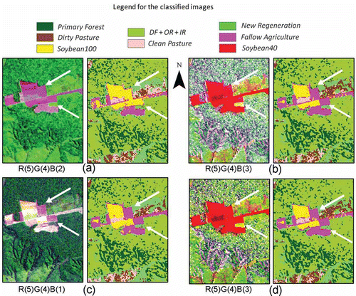
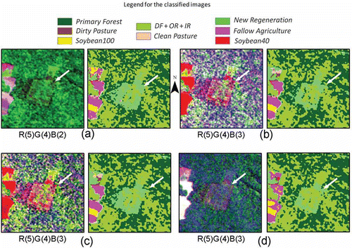
Area 1 is primarily composed of the Fallow Agriculture, Soybean100, Soybean40, and Primary Forest classes. illustrates Area 1 and shows the color composition and the classification of TM as well as those corresponding to the three sets that provided visual improvement in the identification of different areas when compared with the TM data. These compositions result from the fusions of the TM with the HH band and with both bands, which indicates the importance of HH polarization for discriminating these classes. The Fallow Agriculture areas, which are indicated with white arrows, are classified correctly when HH or both polarizations are used in the PC fusion process. These areas were wrongly classified as Soybean100 on the TM classification. Besides the good classification results obtained by the PC 2TM_HH fusion, it also reveals a visually higher discrimination of agricultural plots in the color composition. This color composition clearly displays the geomorphological structures of the area, and it better preserves the color composition of the TM image.
Figure 4. The best visual color compositions and their respective classifications of Area 1: (a) TM, (b) PC 1TM_HH, (c) PC 2TM_HH, and (d) PC 1TM_PC 1(HH&HV).
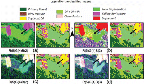
The Primary Forest, DF + OR + IR, and New Regeneration are the predominating classes in Area 2 (). It is known from the fieldwork that selective logging has occurred in the area indicated with the white arrow and that this area is currently in the process of regeneration (DF + OR + IR class). This area was better highlighted by the compositions resulting from fusions in which HV polarization was involved. This fact can be explained by the differences in intensity of volume scattering that these classes may present. The classification based only on the TM image overestimates the New Regeneration class in this area, whereas the classifications arising from the fusions with HV polarization are more accurate.
Figure 5. The best visual color compositions and their respective classifications of Area 2: (a) TM, (b) PC 1TM_HV, (c) PC 1TM_PC 1(HH&HV), and (d) PC 2TM_PC 1(HH&HV).
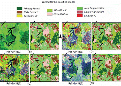
In Area 3 (), it is possible to observe different forest areas on the compositions related to the PC 1TM_HV, PC 2TM_HV, and PC 2TM_PC 1(HH&HV) fusions. The visual improvement due to data fusion is evident when compared with the color composite of TM. Again, the compositions indicate that these differences were due to fusions in which the HV polarization is involved. This fact can be explained by the difference in volume scattering of these areas. However, this visual improvement is not reflected in the classification results because none of the classifications discriminates the area identified by the black arrow, which is better seen in the color composition when radar images are replaced in the second PC ( and ).
Figure 6. The best visual color compositions and their respective classifications of Area 3: (a) TM, (b) PC 1TM_HV, (c) PC 2TM_HV, and (d) PC 2TM_PC 1(HH&HV).
In Area 4, shown in , the fusion of the TM image with both radar bands provides a visual improvement of areas with different structural patterns, as indicated by the arrows. However, as in Area 3, the visual improvement in the composition is not reflected in the classification results, which is very similar to that obtained by the TM classification.
Figure 7. The best visual color compositions and their respective classifications of Area 4: (a) TM, (b) PC 1TM_HH, (c) PC 1TM_PC 1(HH&HV), and (d) PC 2TM_PC 1(HH&HV).
Quantitative analysis of the classifications
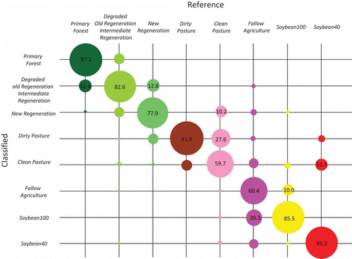
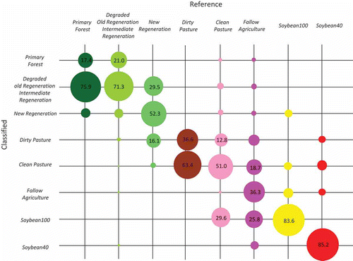
and 9 provide a graphical representation of the confusion matrices of the original TM and SAR classifications, respectively. The diagonal values in these figures represent, for each class, the percentage of pixels correctly classified, and the sizes of the circles are proportional to these percentages. Only values considered relevant (numerically greater than or equal to 10%) are reported. With the use of only the TM image, it is possible to obtain a good classification result, despite the confusion among some classes, particularly for the Fallow Agriculture and for the Clean Pasture classes, with almost 40% of them classified as other classes. In contrast, the classification using only PALSAR image generally shows a high confusion among classes, except for the DF + OR + IR class and for the two classes of Soybean.
Figure 8. The confusion matrix of the TM classification.
The values of kappa coefficients of agreement, their variances and the overall accuracy of the 11 classifications were computed, and hypothesis tests for the equality of the classifications were performed using the kappa and the overall accuracy values. Because the results of both tests were similar, the analysis will be conducted based on the kappa values. The classifications arising from the fusions in which SAR data replaces PC 2 of TM did not present satisfactory results. The kappa values of the classifications PC 2TM_HV, PC 2TM_HH, and PC 2TM_PC 1 (HH&HV) were 0.750, 0.741, and 0.746, respectively, which were statistically equal to the kappa value of the TM classification (0.734). Therefore, in the subsequent analysis, the classification results of these fusions will not be assessed.
The kappa coefficient of agreement for each class, the global kappa values, their variances and the overall accuracies are presented in for the remaining classifications. The results of the hypothesis tests indicate that the PALSAR image classification yielded a kappa coefficient of agreement that is statistically lower than those obtained by all other classifications. This result illustrates, as shown in , the difficulty in discriminating the LULC classes under study when only using the radar amplitude images. The different gray levels in identify the classifications for which the kappa coefficients values are significantly worse than (light gray), equal to (white), or better than (dark gray) the classification of the TM image. Therefore, except for the TM_HV (C1) classification result, all classifications using fusion or combination with TM image present global kappa and overall accuracies statistically better than that obtained only with the TM image. This fact, together with the classification results obtained with the SAR image, justifies the joint use of optical and radar images as well as additional studies to determine the best set of data and how to integrate them (by fusion or combination) for mapping the LULC classes.
3 Values of the kappa coefficient of agreement per class, global kappa, and overall accuracies for fused and combined image classifications.
Figure 9. The confusion matrix of the PALSAR classification.
The highest global kappa value (0.777) was obtained for the classification that uses the combination of the original images of TM and both SAR data (C3). The test of hypothesis indicated that this classification is statistically superior to TM, PALSAR, and TM_HV classifications and equal to all other classifications.
The per-class classification results of F1 to F3, and C1 to C3 were compared to verify the existence of a proper method for integrating optical and radar data (by fusion or combination) for the LULC mapping. This verification was performed by computing the kappa coefficient for each class () and analyzing the test of hypothesis of equality between pairs of kappa values at a 5% significance level. The values in bold in indicate the classification with the highest kappa values for the class in question or values that are statistically equal to the highest value at a 5% significance level. The highest kappa for each class is indicated by a different font.
From the per-class kappa values shown in , it can be observed that the introduction of radar may contribute significantly to the classification of DF + OR + IR, Dirty Pasture, and Soybean40 classes, depending on both, the integration technique and radar polarization. The HH polarization is particularly important for a better discrimination of the DF + OR + IR class, since the classifications that use this band (F2, F3, C2, and C3) have kappa values statistically superior than the TM classification. The polarization HH, when combined with TM (C2), is also responsible for a better discrimination of the Dirty Pasture class. The Soybean40 class is better discriminated when both radar polarizations and the combination technique are used. The introduction of radar data does not significantly contribute to the classification of the Primary Forest, New Regeneration, Clean Pasture, Follow Agriculture, and Soybean100 classes. It can also be observed that image fusion using PC only improves the classification of DF + OR + IR class, and it may even worsen the classification results of Fallow Agriculture class. On the contrary, the classifications performed using combined data do not worsen and may improve the results of the classifications when compared to the TM classification. Therefore, from the above results, it can be said that the combination of bands, in comparison to PC data fusion, appears to be a better option for data integration in the classification of the study area.
illustrates, for classifications with combination of bands, the kappa coefficient values for each class. This figure also presents the kappa values individually obtained with the TM and PALSAR classifications as references. The numbers on the top of the figure represent the percentage increases in the per-class kappa coefficient that are statistically significant, with respect to the kappa value of the TM classification.
Figure 10. Kappa values per class for classifications with combination of bands.
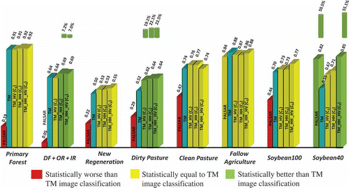
As shown in and (and confirmed by the hypothesis tests), the classes of DF + OR + IR, Dirty Pasture, and Soybean40 are better discriminated using both polarizations (TM_HH_HV classification), with an increase in the kappa values of 7.0%, 22.5%, and 55.1 %, respectively, when compared to the values obtained using TM image. The combination of TM and HH polarization (TM_HH) gives also good results for the classification of DF + OR + IR and Dirty Pasture classes, with an increase in the kappa´s values of 7.2% and 22.1%, respectively. The Dirty Pasture class was also well classified with the combination of TM and HV polarization, with an increase of 19.1% in the kappa value.
The classification of TM_HH_HV (C3) presented the value of the global kappa coefficient statistically equal to that of TM_HH (C2) classification. The highest difference between these two classifications refers to the class of Soybean40, which is the best discriminated when the two polarizations are used. This class presented the highest increase in the kappa value when compared to the TM image classification (55.1%). Therefore, for the classification purposes of the study area, it is suggested the use of both radar polarizations in combination with TM image. If a single polarization needs to be chosen, then it is recommended that the polarization HH should be used.
Another fact that attracts the attention is the good performance of the PALSAR image in the classification of Soybean40 class, with an increase in the value of the kappa coefficient of 50.5% with respect to the corresponding value of the TM image classification.
Besides the examination of the per-class kappa values, another way of analyzing the improvements obtained in classes’ classification results with the use of radar data is through the investigation of the confusion matrix, and of the user and producer accuracies (PAs).
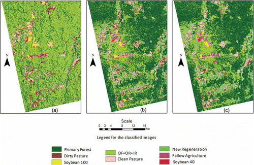
The confusion matrix of the C3 classification, considered as the best classification, is illustrated in . presents the PAs and UAs for the TM and C3 classifications and highlights the classes for which the C3 classification results are better than (dark gray), worse than (light gray), or equal to (white) the TM results. presents the classification results of PALSAR, TM, and the combination of TM with radar (C3) images.
4 The producer (PA) and user (UA) accuracies for TM and TM_HH_HV classifications.
Figure 11. The confusion matrix of the TM_HH_HV classification.
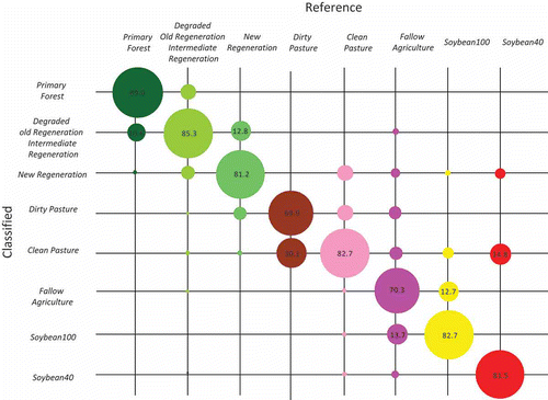
Figure 12. Classified images: (a) PALSAR, (b) TM, and (c) TM_HH_HV.
The results obtained by the analysis of UAs () are very similar to those obtained by the kappa coefficient of agreement, which shows that the use of radar provides UA and kappa values for the DF + OR + IR, Dirty Pasture, and Soybean40 statistically superior to the classification using TM data. However, the analysis of the PA and the comparison of and show a classification improvement of the Primary Forest, DF + OR + IR, Clean Pasture, and Fallow Agriculture classes. The classes of New Regeneration and Soybean100 had no improvements in UA and neither in PA. Only the DF + OR + IR class had an improvement in both accuracies. This radar contribution for a better classification of DF + OR + IR class had been already observed by the fusion visual analysis of Area 2 ().
The only statistically significant decrease in the values presented in occurred to the Clean Pasture class. From and , it is possible to observe that the high confusion between Dirty and Clean Pasture classes occurs both, in the classification of TM image (several pixels of Clean Pasture being classified as Dirty Pasture), as well as in the classification of the combined data (various pixels from Dirty Pasture being classified as Clean Pasture).
A comparison of with shows that the PA for Fallow Agriculture increases from 60.4% to 70.3% when using C3 instead of the TM classification alone. Therefore, the number of pixels from this class that are misclassified in the other classes decreases when radar data are introduced in the classification process. Most of these pixels were classified as soybean when TM was used alone. Therefore, the improvement in the PA of the Fallow Agriculture class is responsible for the improvement in the reliability (UA) and in the kappa values for soybean classes, in especial for Soybean40.
The accuracy analysis leads to the conclusion that, with the exception of the classes of New Regeneration and Soybean100, the combined use of TM and radar data improves significantly at least one of the indexes, UA or PA. In addition, except for the Dirty Pasture class, the increase of one of these indexes occurs without diminishing the other.
The significant improvement in the UAs values is, in descending order, Soybean40 (an increase of about 55%), Dirty Pasture (22%), and DF + OR + IR (5%). These figures for PAs are Clean Pasture (39%), Fallow Agriculture (16%), DF + OR + IR (3%), and Primary Forest (2%).
Conclusions and final considerations
This article presents different methods for integrating optical and radar data in a test area of the Brazilian Amazon with the goal of improving the LULC mapping. Data fusions with PCs and the combinations of data were used to assess the objectives.
With regard to the visual analysis, fusing the TM image with radar generally provides images with more clearly defined classes. The attempt to introduce radar data in the second PC of TM resulted in images with good visual potential for discriminating soybean areas but not for differentiating regions of different successional stages.
A visual analysis was presented for four different subregions of the image. Agricultural areas, which predominate in the first subregion, were visually better discriminated in the fusions where HH polarization was present, revealing the importance of this polarization for classifying these areas. Furthermore, the HV-band-highlighted areas in different stages of regeneration present in subregions 2 and 3, although HH also contributed to an improved visual performance. However, when the fused images were used to classify the LULC classes, this visual improvement was not entirely reproduced in the classification results.
The integration of optical and radar data obtained with the combination of data produced statistically better results than those obtained with data fusion using PCs and those obtained when only the original images (TM or PALSAR) were used. Furthermore, information from the HH polarization contributes more than that from HV polarization to the discrimination the classes, although the use of both polarizations produces kappa results that are statistically better than those obtained with a single polarization. Therefore, for purposes of the classification of the study area, the combination of TM image with both polarizations (TM_HH_HV), is recommended for achieving best results.
An important point to be emphasized is the good performance of PALSAR to discriminate the class of Soybean40. To assess the discriminatory capability of these images for soybean crops classification, it is suggested that more tests and analyses to be carried out with these images, in areas that predominates the soybean culture.
The kappa values for the LULC classes under analysis reproduce the reliability of the classes because their values are very similar to the UA values. A proper method of analyzing the classification results of each class may be the use of a combination of user and PAs. Therefore, more studies should be conducted to evaluate the classification results using this combination.
Acknowledgments
The authors are grateful to CNPq, FAPESP, CAPES, and NSF for partially supporting this research and to JAXA for providing the ALOS/PALSAR data.
Related Research Data
References
- Ban , Y. , Hu , H. and Rangel , I. M. 2010 . Fusion of Quickbird MS and RADARSAT SAR Data for Urban Land Cover Mapping: Object-Based and Knowledge-Based Approach.” . International Journal of Remote Sensing , 31 ( 6 ) : 1391 – 1410 .
- Cakir , L. H. and Khorram , S. 2008 . Pixel Level Fusion of Panchromatic and Multispectral Images Based on Correspondence Analysis.” . Photogrammetric Engineering & Remote Sensing , 74 ( 2 ) : 183 – 192 .
- Chavez , P. S. Jr. , Berlin , L. and Sowers , L. B. 1982 . Statistical Method for Selecting Landsat MSS Ratios.” . Journal of Applied Photographic Engineering , 8 ( 1 ) : 23 – 31 .
- Chavez , P. S. Jr. , Sides , S. C. and Anderson , J. A. 1991 . Comparison of Three Different Methods to Merge Multiresolution and Multispectral: Landsat TM and SPOT Panchromatic.” . Photogrammetric Engineering & Remote Sensing , 57 ( 3 ) : 295 – 303 .
- Congalton , R. G. and Green , K. 2009 . Assessing the Accuracy of Remotely Sensed Data: Principles and Practices, 183 p , Boca Raton, FL : CRC Press, Taylor & Francis Group .
- Dong , J. , Zhuang , D. , Huang , Y. and Fu , J. 2009 . Advances in Multi-Sensor Data Fusion: Algorithms and Applications.” . Sensors , 9 ( 10 ) : 7771 – 7784 .
- Dutra , L. V. , Elmiro , M. T. , Freitas , C. C. , Santos , J. R. , Mura , J. C. and Filho , B. Soares . 2002 . “ The Use of Multi-Frequency Interferometric Products to Improve SAR Imagery Interpretability and Classification by Image Fusion.” . In Proceedings of III Workshop em Tratamento de Imagens: Núcleo de Processamento Digital de Imagens , Belo Horizonte : CD-ROM . MG, Brazil, June 27–28, 172–179
- Escada , M. I. S. , Amaral , S. , Rennó , C. D. and Pinheiro , T. F. 2009 . Levantamento Do Uso e Cobertura Da Terra e Da Rede De Infraestrutura No Distrito Florestal Da BR-163 , 52 São José dos Campos : Instituto Nacional de Pesquisas Espaciais .
- Freitas , C. C. , Soler , L. , Sant´Anna , S. J. S. , Dutra , L. V. , Santos , J. R. , Mura , J. C. and Correia , A. H. 2008 . Land Use and Land Cover Mapping in the Brazilian Amazon Using Polarimetric Airborne P-Band SAR Data.” . IEEE Transactions on Geoscience and Remote Sensing , 46 ( 10 ) : 2956 – 2970 .
- Frery , A. C. , Freitas , C. C. and Correia , A. H. 2007 . Classifying Multifrequency Fully Polarimetric Imagery with Multiple Sources of Statistical Evidence and Contextual Information.” . IEEE Transactions on Geoscience and Remote Sensing , 45 ( 10 ) : 3098 – 3109 .
- Haralick , R. M. , Sternberg , S. R. and Zhuang , X. 1987 . Image Analysis Using Mathematical Morphology.” . IEEE Transactions on Pattern Analysis and Machine Intelligence , 9 ( 4 ) : 532 – 550 .
- Huang , S. , Potter , C. , Crabtree , C. R. L. , Hager , S. and Gross , P. 2010 . Fusing Optical and Radar Data to Estimate Sagebrush, Herbaceous, and Bare Ground Cover in Yellowstone.” . Remote Sensing of Environment , 114 ( 2 ) : 251 – 264 .
- Laurila , H. , Karjalainen , M. , Kleemola , J. and Hyyppä , J. 2010 . Cereal Yield Modeling in Finland Using Optical and Radar Remote Sensing.” . Remote Sensing , 2 ( 9 ) : 2185 – 2239 .
- Li , G. , Lu , D. , Moran , E. and Hetrick , S. 2011 . Land Cover Classification in a Moist Tropical Region of Brazil with Landsat Thematic Mapper Imagery.” . International Journal of Remote Sensing , 32 ( 23 ) : 8207 – 8230 .
- Lu , D. , Batistella , M. and Moran , E. 2007 . Land Cover Classification in the Brazilian Amazon with the Integration of Landsat ETM+ and Radarsat Data.” . International Journal of Remote Sensing , 28 ( 24 ) : 5447 – 5459 .
- Lu , D. , Li , G. , Moran , E. , Dutra , L. V. and Batistella , M. 2011 . A Comparison of Multisensor Integration Methods for Land Cover Classification in the Brazilian Amazon.” . GIScience and Remote Sensing , 48 ( 3 ) : 345 – 370 .
- Mcnairn , H. , Champagne , C. , Shang , J. , Holmstrom , D. and Reichert , G. 2009 . Integration of Optical and Synthetic Aperture Radar (SAR) Imagery for Delivering Operational Annual Crop Inventories.” . ISPRS Journal of Photogrammetry and Remote Sensing , 64 ( 5 ) : 434 – 449 .
- Pouteau , R. , and , B. and Stoll . 2011 . “ Fusion for Classes in Difficulty: For Accurate and Speed Tropical Rainforests Classification.” . In Proceedings of IEEE International Geoscience and Remote Sensing Symposium (IGARSS’ 2011) 740 – 743 . Vancouver, BC Canada, July 24–29, ISBN 978-1-4577-1005-6.
- Renzullo , L. , Barrett , D. , Marks , A. , Hill , M. J. , Guerschman , J. P. , Mu , Q. and Running , S. W. 2008 . Multi-Sensor Model-Data Fusion for Estimation of Hydrologic and Energy Flux Parameters.” . Remote Sensing of Environment , 112 ( 4 ) : 1306 – 1319 .
- Rodrigues , S. W. P. and Souza-Filho , P. W. M. 2011 . Use of Multi-Sensor Data to Identify and Map Tropical Coastal Wetlands in the Amazon of Northern Brazil.” . Wetlands , 31 ( 1 ) : 11 – 23 .
- Santos , C. and Messina , J. P. 2008 . Multi-Sensor Data Fusion for Modeling African Palm in the Ecuadorian Amazon.” . Photogrammetric Engineering & Remote Sensing , 74 ( 6 ) : 711 – 723 .
- Silva , W. B. , Pereira , L. O. , Sant´Anna , S. J. S. , Freitas , C. C. , Guimarães , R. J. P. S. and Frery , A. C. 2011 . “ Land Cover Discrimination at Brazilian Amazon Using Region Based Classifier and Stochastic Distance.” . In Proceedings of IEEE International Geoscience and Remote Sensing Symposium (IGARSS’ 2011) 2900 – 2903 . Vancouver, BC Canada, July 24–29, ISBN 978-1-4577-1005-6.
- Sousa , M. A. Jr. 2005 . “Multilevel and Multimodel Segmentation for Radar and Optical Images.” [In Portuguese.] PhD thesis, National Institute of Space Research 131 São José dos Campos
- Torrion , J. A. 2002 . “Land Degradation Detection Mapping and Monitoring in the Lake Naivasha Basin Keya.” MSc diss., International Institute for Geo-Information Science and Earth Observation, Enschede 94
- Walker , W. S. , Baccini , A. , Kellndorfer , J. M. , Stickler , C. M. , Sun , M. , Laporte , N. T. and Goetz , S. J. 2011 . “ Mapping of Land Cover and Above-Ground Biomass in the Amazon Basin from Multi-Spectral Fusion of ALOS/PALSAR and LANDSAT Data Sources.” . In Proceedings of IEEE International Geoscience and Remote Sensing Symposium (IGARSS’ 2011) , Vancouver, BC : Unpaginated DVD. ISBN 978-1-4577-1004-9 . Canada, July 24–29,
- Walker , W. S. , Stickler , C. M. , Kellndorfer , J. M. , Kirsch , K. M. and Nepstad , D. C. 2010 . Large-area Classification and Mapping of Forest and Land Cover in the Brazilian Amazon: A Comparative Analysis of ALOS/PALSAR and Landsat Data Sources.” . IEEE Journal of Selected Topics in Applied Earth Observations and Remote Sensing , 3 ( 4 ) : 594 – 604 .
- Walker , W. S. , Wellndorfer , J. , Lapoint , E. , Hoppus , M. and Westfall , J. 2007 . An Empirical InSAR-Optical Fusion Approach to Mapping Vegetation Canopy Height.” . Remote Sensing of Environment , 109 ( 4 ) : 482 – 499 .
- Waske , B. and Benediktsson , J. A. 2007 . Fusion of Support Vector Machines for Classification of Multisensor Data.” . IEEE Transactions on Geoscience and Remote Sensing , 45 ( 12 ) : 3858 – 3866 .
- Waske , B. and Linden , S. V. D. 2008 . Classifying Multilevel Imagery from SAR and Optical Sensors by Decision Fusion.” . IEEE Transactions on Geoscience and Remote Sensing , 46 ( 5 ) : 1457 – 1466 .
- Wijaya , A. , and , R. and Gloaguen . 2009 . “ Fusion of ALOS PALSAR and Landsat ETM Data for Land Cover Classification and Biomass Modeling Using Non-Linear Methods.” . In Proceedings of IEEE International Geoscience and Remote Sensing Symposium Cape Town, South Africa, July 12–17, 581–584. ISBN 978-1-4244-3395-7. (IGARSS’ 2009)
- Xiaoying , J. 2009 . Segmentation based image processing system. US Patent 0,123,070 Wilmington, DE: ITT Manufacturing Enterprises Inc.
- Zhang , J. 2010 . Multisource Remote Sensing Data Fusion: Status and Trends.” . International Journal of Image and Data Fusion , 1 ( 1 ) : 5 – 24 .
- Zhang , Y. 2004 . Understanding Image Fusion.” . Photogrammetric Engineering and Remote Sensing , 70 : 657 – 661 .