Abstract
Numerous studies have examined the correlation between socioeconomic statistics and night light (NL) imagery. Previous studies have shown that the NL data correlates well with gross domestic product (GDP) statistics. This study calls for a focus on process over correlation between the variables so as to better inform scaled models of the relationship. A focus on process is addressed in this study by examining the relationship between the variables at two scales and two time periods. The two scales examined are: States and Metropolitan Statistical Areas (MSA). The MSA scale exhibits a stronger relationship with the NLs over the State scale, and the results at either scale are consistent through time. However, the models examined here are miss-specified at all scales. Examination of outliers and residuals informs for future well-described models of the relationship.
1. Introduction
1.1. The DMSP-OLS
VNIR (visible light) remotely sensed images from the Defense Meteorological Satellite Program (DMSP) Optical Linescan System (OLS) “night lights” (NLs) instruments are designed to monitor clouds and weather patterns for United States Air Force meteorologists (Kramer Citation1994). Multiple data products created from the DMSP-OLS observations are available from the National Oceanic and Atmospheric Administration (NOAA) National Geophysical Data Center (NGDC) website at http://www.ngdc.noaa.gov/dmsp/dmsp.html. Data from Version 4 of the DMSP-OLS Nighttime Lights Time Series are available in digital form from 1992 to the present, and are easily accessible via direct download from the Internet.
The NL images comprise yearly averaged cloud-free composites using all available archived DMSP-OLS smooth resolution data for the given calendar years. These yearly averaged stable light images comprise global coverage, and span nearly 20 years of visible light data remotely sensed on the Earth's surface. While the recently launched NOAA-NASA-Department of Defense (DOD) Suomi National Polar-orbiting satellite delivers higher resolution night light data as compared to the DMSP-OLS, the Suomi lacks the historical data that is available from the DMSP-OLS data repository provided by the NGDC. If the DMSP-OLS program is continued into the future, additional data will continue to be available at the coarser resolution given by the DMSP-OLS sensors, making it especially relevant to time series analysis. As a time series, the DMSP-OLS NL data are invaluable for change analysis if a better understanding of the human activity processes represented by the data is determined.
Numerous studies have examined the correlation between socioeconomic information such as economic activity and the data provided by the visible light “city lights” band of the DMSP-OLS system. These studies have examined correlation at multiple scales between the NL data sets and economic activity (Sutton et al. Citation1997; Doll, Muller, and Elvidge Citation2000; Elvidge et al. Citation2001; Sutton and Costanza Citation2002; Ebener et al. Citation2005; Doll, Muller, and Morley Citation2006; Propastin and Kappas Citation2012), population (Elvidge et al., “Relation Between Satellite,” 1997, Elvidge, Baugh, Hobson, et al. 1997, 2001; Doll, Muller, and Elvidge Citation2000; Sutton et al. Citation2001; Balk et al. Citation2006; Propastin and Kappas Citation2012), population density (Sutton Citation1997, Citation2003), carbon dioxide (CO2) emissions (Elvidge, Baugh, Hobson, et al. Citation1997; Doll, Muller, and Elvidge Citation2000; Propastin and Kappas Citation2012), and energy usage statistics (Elvidge et al., “Relation Between Satellite,” Citation1997, Citation2001; Amaral et al. Citation2005; Chand et al. Citation2009).
Numerous studies have shown that the NL data correlates well with gross domestic product (GDP) as a proxy for economic activity at all examined scales. The strong relationship between NL lit area and GDP at the country level was shown in (Elvidge et al., “Relation Between Satellite,” Citation1997), and was confirmed for a larger number of countries by Doll, Muller, and Elvidge (Citation2000) and Elvidge et al. (Citation2001). Doll, Muller, and Elvidge (Citation2000) found that lit area correlates well with GDP and CO2 emissions at regional and national scales. Sutton and Costanza (Citation2002) examined the 1995 gross state product, a modified form of GDP, for the coterminous United States against the DMSP-OLS data set and achieved an R 2 value of 0.86 (see also Ghosh et al. Citation2009). The NL data are already accepted as a proxy for population, population density (Sutton et al. Citation1997), and economic statistics (Doll, Muller, and Elvidge Citation2000), but only at specific scales with specific models. A better understanding of the socioeconomic processes represented by the NL data at all scales would be of benefit to many different areas of research, including local, regional, and global sustainability investigations.
1.2. Scale, patterns, and process
The DMSP-OLS NL satellite instruments were originally designed to collect cloud imagery for visual interpretation of clouds by United States Air Force meteorologists (Kramer 1994) and have been shown to observe and record human social and economic activity occurring on the Earth's surface. Social and economic activity systems are considered to be complex systems, lacking linearity in scaled processes. Economic activity systems are complex at multiple scales, and “interactions may occur within or across scales, leading to substantial complexity in dynamics” (Cash et al. Citation2006, 2). It is inherently understood that economic processes differ as they scale up or down, from city to state to nation to global, and that “scales are produced, whether by human-social, geophysical or biological processes” (Sayre Citation2009, 105). In order to make sense of the complex processes captured by the NL imagery, there is a need for multiple lenses, i.e. multiple models to help us understand the data generated by the DMSP-OLS, to help us understand patterns found, find hidden parameters, and develop a deeper understanding of the patterns and processes observed and captured by the DMSP-OLS visible light instruments. Focusing on processes in the analysis may yield better insight into the patterns and processes captured by the DMSP-OLS.
Past studies examining the correlation between socioeconomic statistics and the DMSP-OLS NL data incorporated scale by examining the same relationship between variables at single or (inferred) multiple scales and applying the same model at different scales (Elvidge et al., “Mapping City Lights with Nighttime Data,” Citation1997; Sutton et al. Citation1997). The focus of these previous studies is, for the most part, correlation, estimation, or prediction, rather than understanding of the processes observed (Cash et al. Citation2006). In embracing the assumption that there is no single, correct scale that applies to a system as a whole (Cash et al. Citation2006), and focusing instead on how the processes change as scale [as level] changes, it should be possible to increase understanding of what the DMSP-OLS NL data represent. “Widespread agreement exists that explanatory variables for a given phenomenon change as the scale [as level] of analysis changes” (Gibson, Ostrom, and Ahn Citation2000, 226). “Identifying the operational scales of processes and reconciling them with observational scales are therefore central challenges of research” (Sayre Citation2009, 98), and is the focus of this study. Focusing on processes between the variables informs models at varying scales and reduces the potential to commit ecological fallacy in the examination.
Scale is defined by Richard Howitt (Citation1998, Citation2002) as having three different aspects or facets: size, level, and relation. Scale as size refers to cartographic scale, image resolution (or observational grain size), and study extent. For example, the Version 4 DMSP-OLS stable lights NL images have a resolution of about 1 km2, so the image scale as size is 1 km2. Scale as level is sometimes used interchangeably for scale (Sayre Citation2005), but is here referred to as “a locus of organization or observation” (Sayre Citation2005, 282). By this definition, levels are created to allow us to differentiate between different scales [as size] and to organize scales [as size] in some fashion (Sayre Citation2005). A scale as level need not entail relations or processes at all, but can be employed to examine relations and processes at different scales.
Exploring relations among phenomena at different scales can reveal scaling effects, mismatches of scale or rescaling issues (Sayre Citation2009). Understanding of the relationship between socioeconomic statistics and the NL data benefits from examination at multiple scales, preferably using one method, allowing for focus on relationships and processes between the variables, not correlation, prediction or estimation. This understanding would also benefit from an examination of differences in the relationship between the variables as they are scaled up and down. Many previous studies examining correlation between socioeconomic variables and the NL data found regional variation (Doll, Morley, and Muller Citation2004; Elvidge et al. Citation2005; and others). It is important to note that regional variation found is simply variation found between one scale and another. Any conclusions made for regional variation in the model examined is just an informal way of saying that the model examined is mis-specified at the regional scale.
Time is just another scale, and processes are simultaneously spatial and temporal (Sayre Citation2009). “Temporal scale can be thought of as divided into different ‘time frames’ related to rates, durations, or frequencies” (Cash et al. Citation2006, 2). “Phenomena happen at a range of different time frames,” (Cash et al. Citation2006, 2) from the slow change of tectonic plate movement to the rapid changes of hurricanes. In order to better understand the process, it is therefore also important to examine differences in the relationship between examined variables as they change both forward and backward through time.
It is not known whether changes observed in lights are simultaneous with changes in economic activity or if there is some temporal lag. By utilizing methods that focus on process rather than correlation, estimation or prediction, an understanding of correlation direction between variables is possible. Understanding correlation direction will better inform understanding of the relationship between the variables. Allowing each of the two theoretically related variables to stand as the dependent variable without assumption of direction may increase understanding of the process in the relationship examined. Furthermore, thorough examination and explication of outliers and residuals may provide valuable information about the relationship between the examined variables and the choice of variables examined. Outliers and residuals contain valuable information about the variables within the model and may also provide clues to the process and the relationship between the variables.
This study therefore examines the relationship between two variables, GDP as a proxy for economic activity, and the brightness values (BVs) from the DMSP-OLS visible light band imagery. The method here focuses on process rather than correlation, prediction, or estimation. Two specific political scales are examined using one consistent method: the Metropolitan Statistical Area (MSA) and states within the United States. Regional variation for both scales is also examined using geographically weighted regression (GWR), hence, the number of total scales examined is four. Temporal scales are also examined using two different time periods: 2006 and 2010. These years were chosen because they bound 2007 to 2008, the years marking the failure of the subprime mortgage market and the subsequent recession in the United States. The choice of these years allows us to compare correlation results between two very different economies at multiple spatial scales.
This study, therefore, seeks to examine economic activity patterns of variability in space and time as represented by the DMSP-OLS NL imagery, and to understand how those patterns change with scale so as to better understand the relationship between GDP and imagery. It is hoped that the results of this study will then inform future research for time series analysis of the relationship between socioeconomic variables and the DMSP-OLS stable lights NL data.
2. Data
Yearly averaged images from the Version 4 DMSP-OLS Nighttime Lights Stable Lights time series were obtained from the NGDC website based in Boulder, Colorado, a division of the NOAA. The Version 4 DMSP-OLS nighttime stable lights files are cloud-free composites using all available archived DMSP-OLS smooth resolution data for the given calendar years. Different sensor clusters for different years within the entire series of Stable Lights images are shown in . For 2006, the data from the F16 sensor cluster was used. For 2010, the F18 Stable Lights image was used, the only data set available for that year. A thorough discussion of how the DMSP OLS Stable Lights images are created is available in Elvidge et al., “Relation Between Satellite,” (Citation1997) and Elvidge et al. (Citation1999).
Table 1. DMSP-OLS sensor cluster collection years.
GDP data for each political scale (MSA, State) were obtained from the Bureau of Economic Analysis (BEA) website at www.bea.gov. GDP is defined by the BEA as the measure of the total market value of goods and services produced by workers and capital within a given border during a given time period. GDP data are available for multiple time periods and spatial extents. For privacy reasons, the smallest scale available for GDP data is the MSA.
Two spatial political extents are examined here. The first is the MSA. In the United States, MSAs are available as select aggregated counties that occasionally cross state lines. MSAs are defined by the BEA as urbanized areas with at least 50,000 residents, containing the core county as well as contiguous counties exhibiting a high degree of social and economic interaction with the core. Forbes (Citation2011) examined the relationship between GDP statistics and the NL at the MSA spatial extent in the state of Florida and found a very strong relationship (R 2 = 0.984). As far as is known, no other studies have examined the relationship between GDP and the NL data sets at the MSA scale in the United States. This study expands on Forbes (Citation2011) to examine all MSAs in the contiguous United States. The second spatial extent examined here is the next higher political extent: the state. States are examined here using exactly the same data and methodology as in Forbes (Citation2011) to allow comparison with previous studies using different methods, and as an attempt to determine the sub-national scale in the United States with the highest correlation between the variables for the examined model. Both extents are further examined for spatial autocorrelation (regional scales) for a total of four spatial extents examined.
A polygon shape file of all US county boundaries was obtained from the Oak Ridge National Laboratory's Center for Transportation Analysis (ORNL CTA). According to the ORNL CTA website, this county boundary shape file was extracted from 1993 TIGER/Line by the ORNL CTA, with minor editing and edge-matching performed by the ORNL CTA. Alaska, Hawaii, and the territories were removed from the data set before any further processing was completed. Removal of these areas allows for GWR analysis of contiguous or proximal polygons to serve as regional scales. Washington DC was removed from the State data set in this study due to errors identified in the shape file.
3. Methods
The original NL files were downloaded as global composites and projected to the USA Contiguous Albers Equal Area Conic United States Geological Survey projection. The projected NL global data sets were then subset to contain the contiguous United States. Digital numbers in the NL data sets range from 0 to 63. These digital numbers (hereafter called brightness values or BVs for brevity) from both yearly images were summed using ESRI Zonal Statistics (ArcGIS 10.0.3; Esri, Redlands, CA, USA) tools to the four political extents, two per year (2006 MSAs, 2010 MSAs, 2006 States, 2010 States) to create the BV statistic used in this study.
The US administrative boundaries extend out over water bodies, both inland and coastal. Due to documented blooming or overglow over water (Small, Pozzi, and Elvidge Citation2005) within the NL data sets, administrative boundaries in the ORNL CTA shape file were edited to coastlines around major inland water bodies to ensure only land-based digital numbers (BVs) were summed. The edited ORNL CTA county boundary shape file was then dissolved into multi-part county features which were then dissolved separately into MSA and State extents. Mapping of county boundaries to BEA MSA definitions differ between 2006 and 2010; MSAs were added or existing MSA boundaries were changed between 2006 and 2010. Therefore, a separate MSA shape file was created for each year, one for 2006 and one for 2010.
GDP statistical data for each year and for each scale were downloaded from the BEA website, checked for completeness, and then assembled into four yearly files. Statistical data were then joined to the spatial data, two for each year (2006 and 2010) and for each spatial extent, resulting in four complete data sets. For each of the data sets, the dependent variable was held to be either GDP or the BVs, giving eight sets of results for the entire study.
The methods detailed as follows were applied to all four data sets (2006 MSAs, 2006 States, 2010 MSAs, 2010 States). All variables in each data set were first transformed using base-10 logarithms. Descriptive statistics of all variables were generated, including central tendencies and histograms. Scatter plots of each variable pair were generated for each of the four data sets. Bivariate linear (ordinary least squares or OLS) regression was then performed for each of the four data sets. Because it has been shown that regional influence may exist in the data, GWR was also performed on all four data sets. Scatter plots and maps of residuals resulting from both OLS and GWR were generated for analysis.
4. Results and discussion
contains regression results for all models for all scales and time periods examined. The correlation results for Florida (Forbes Citation2011), which were obtained using the exact same methodology, are included here for comparison and discussion.
Table 2. Model results by spatial extent and year.
First, leverage points were determined from the regression scatter plots ( and ) for all eight OLS regression results. Leverage points in this analysis are those data points which are observed at extremes of the independent variable, but not lying outside three standard deviations of the standardized mean. Leverage points were only identified for models where GDP was the dependent variable. For the models where the BVs are the dependent variable, no data points were easily identified as having strong influence on the slope of the OLS regression line. Not surprisingly, the leverage point for the State-scale OLS models is the state of California and the leverage point for the MSA scale OLS models is the New York–Northern New Jersey–Long Island MSA. What is surprising is that the Los Angeles–Long Beach–Santa Ana MSA does not appear as a leverage point at the MSA scale, but is instead an outlier. All outliers at the MSA scale, defined as data points lying at or greater than 3 standard deviations from the mean of the standardized residuals, are shown in , and outliers are discussed later on in this section.
Table 3. MSA scale residual scatter plots.
Table 4. State scale residual scatter plots.
Table 5. MSA outliers by year, method and dependent variable.
The coefficients of determination shown in for all MSAs in the United States are not as strong as the coefficients of determination for MSAs in Florida only. This may be due to the fact that Florida has only 21 MSAs. There are many more MSA data points available for the contiguous United States, resulting in higher variability, thereby decreasing the strength of the relationship. It is important to note that Forbes (Citation2011) found strong correlation for all MSAs in Florida, including MSAs with high and low population density, large and small geographic area, or very high per-capita income as well as the lowest per-capita income MSAs. It is also important to note that Florida's economy, aptly named the Sunshine Economy (Stronge Citation2008), is highly dependent on tourism and in-migration of people, especially retirees, from other locations (Stronge Citation2008). In other words, the primary industry in Florida is tourism (visits from non-residents) and the secondary industry of Florida is entirely dependent on a rate of change in the population, (in the positive direction, presumably). Florida's attractive weather and climate allow for this type of economic base. While this type of economy is by no means unique in the United States, Florida's very strong tourism industry, extensive coastline and numerous beaches, and its proximity to the Caribbean allows for an economy that differs, in many ways, from most other economies in the United States.
shows that the MSAs exhibit stronger correlation over the State scale. This is not surprising, given that State spatial extents contain both urban and rural areas, and the NL data sets have been shown to correlate better with urban area GDP over rural area GDP. The higher correlation at the MSA scale suggests, however, that the NL data sets contains spatially explicit information about economic activity since the MSAs, by definition, are contiguous regions with high social and economic interaction. The weaker results at the State scale imply that a different model is needed for the State scale over the MSA scale.
The GWR coefficients of determination shown in are stronger when compared to the OLS results, but not by a large magnitude, which is surprising given that numerous other studies have shown that regionality exists in the relationship between GDP and the NL data. GWR, as a measure of regionality, is based on the distance between objects, in keeping with Tobler's (Citation1970) first law of geography, which states that near things are more alike. The application of GWR at the State scale decreases the variance in the dependent variable. This suggests that regional differences in the variables decrease as aggregation increases, and again strengthens the possibility that a different model is needed for the State scale over the MSA scale.
The GWR correlation results are stronger when the BVs are the dependent variable, which suggests that the relationship directionality is from GDP to the BVs. This implies that GDP is a better predictor of the BVs and not vice versa.
One of the assumptions of OLS regression, weighted or not, is that the residuals have equal variance. For non-spatial OLS regression, the assumption is also that the residuals will have equal variances. For GWR, this assumption translates to residuals that are not spatially autocorrelated, i.e., not clustered. Spatial autocorrelation in the GWR residuals was tested using the Global Moran's I tool in ArcGIS 10.0.3. To examine equal variances in the non-spatial OLS regression results, the OLS residuals were tested using the Levene's equality of means tool in SPSS Version 19 as a proxy test of heteroskedasticity in the residuals. The calculations of the Levene's test for Equality of Means, as shown in , appear to be inconclusive. A value closer to 1.0 indicates homoskedasticity, the desired result to meet the assumption of equal variance about the mean in the residuals of OLS regression. A value closer to 0.0 would indicate heteroskedasticity. The results found here, as shown in , vary by dependent variable, by year, and by scale, with no apparent pattern. The calculated Levene's test appears to be inconclusive.
and contain the OLS standardized residual plots for all test results for MSAs () and States (). At the MSA scale for GDP as the dependent variable (), the residuals are highly clustered in the lower values of GDP (the left side of the x-axis), and the variance decreases as x increases, i.e. as GDP increases, the variance decreases. When BVs are the dependent variable, the variables appear to contain almost a linear relationship in the lower values (the left side of the x-axis), implying that a variable may be missing from the model, which would explain the smaller BV data points. The residuals in the plots where BVs are the dependent variable are clustered in the middle range of the BVs and the variance in the residuals is clearly lower in the lesser BVs than in the higher BVs.
Unequal variances also appear in the State OLS plots of the standardized residuals (). The plots where GDP is the dependent variable appear linear, and the variance in the residuals decreases as GDP increases (a decrease in variance from left to right along the x-axis). For the plots where the BVs are the dependent variable, there are extreme values in the lower left side of the plots for those points where the summed BVs are very low. The variance in this region of the plot differs significantly from the variance in the region for points where the BVs are much higher. For all residual plots, the shapes are consistent through time for each dependent variable, indicating consistency in the models through time but not by dependent variable. In other words, at all scales, plot shapes are similar when the BVs are the dependent variable, but those plots are not similar to the plots where GDP is the dependent variable.
Figure illustrates how the Levene's equality of means was calculated for the OLS residuals: the x-axis (in the example, GDP as the dependent variable) is divided into quantiles, where each quantile contains the same number of observations. Then, beginning with the upper left plot in , the first quantile mean is compared with the combined mean of the second, third, and fourth quantiles. For the second test (the upper right plot in ), the combined mean of the first and second quantiles is compared with the combined mean of the third and fourth quantiles. And finally, the combined mean of the first, second and third quantiles is compared with the fourth quantile mean (bottom figure). The results from each of these three tests were then averaged for each year at each scale, which are shown as line items in the results table (). The four measures for each scale (MSAs or State) were then averaged, which is shown in the OLS average column in .
Figure 1. Illustration of Levene's equality of means calculation.
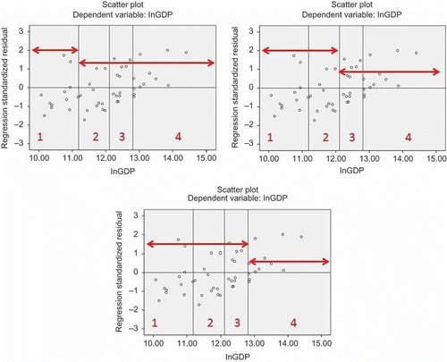
The null hypothesis for Levene's equality of means test is homoskedasticity. The results in the OLS column in represent the percent chance of rejecting the null hypothesis incorrectly, a Type I error. While the Levene's calculations appear inconclusive as to whether to accept or reject the null hypothesis, the plots in clearly illustrate that the variance decreases as GDP increases, moving from the left side to the right side along the x-axis. This change in variance over GDP for the standardized residuals indicates heteroskedasticity in the residuals.
For the GWR residuals, Moran's I, a spatial test of unequal variance, was applied to determine the presence of spatial autocorrelation in the standardized residuals. The desired result in GWR residuals is randomness in the residuals, not clusters. Clusters in the residuals resulting from GWR indicate that spatial autocorrelation exists in the residuals, a violation of the assumption of equality of variance. As shown in , non-clustered residuals only appear at the MSA scale where the BVs are the dependent variable. These are marked with an asterisk in . All other GWR models resulted in clustered residuals, including all of the State models. The p-values resulting from the calculation of Moran's I on the residuals are also reported in , in the column labeled with three asterisks (***). These p-values indicate that confidence is low for the non-clustered residuals for the two MSA scale models.
Outliers for all eight models were compiled and examined. At the State scale, only Rhode Island appears as an outlier, and only for the OLS regression. No outliers at the State scale appear in the GWR models. At the MSA scale, some data points appear as outliers in only one or two models, and several data points appear as outliers in seven or eight models. Outliers for all MSA models are listed in , with an indication as to the models in which they appear as an outlier, subdivided first by year, then by regression method (OLS or GWR) and then further subdivided by dependent variable.
Counts for the number of times a data point (MSAs only) appears as an outlier is listed in the Count column in . Counts for the number of outliers by method/dependent variable appear across the bottom in the Count row. The MSAs that appear as outliers most frequently are: Bridgeport–Stamford–Norwalk, Connecticut; Carson City, Nevada; Corvallis, Oregon; San Jose–Sunnyvale–Santa Clara, California; Trenton–Ewing, New Jersey. The GWR model for 2010, where the BVs are the dependent variable, has the least number of outliers (six) of all models examined here, suggesting that this model explains the greatest number of data points over all the models examined here. All other models have 7, 8, or 9 outliers.
Within the table of outliers, each MSA is shown with its primary and secondary industry types. These industry types are the industries with the highest and second highest amount of GDP generated for the MSA, as determined by the BEA; the industries listed here for each MSA account for the highest and second highest GDP recorded for the respective MSA. Government as industry type within an MSA can refer to national, state, or local government, or any combination thereof. The other industry types shown in the table are self-explanatory. Few industry rankings changed between 2006 and 2010 for the MSAs identified here as outliers.
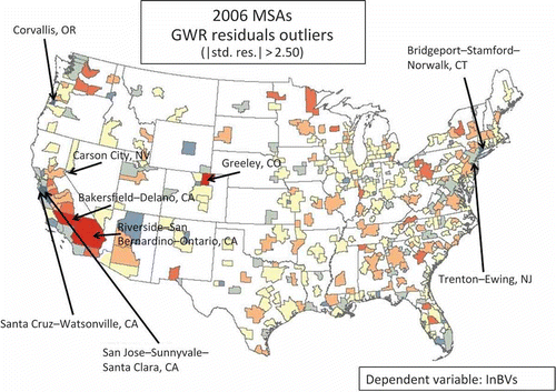
The next column in to the right of the Major Industries is the standardized per capita GDP for each MSA, and the last column to the right in is the US Census Bureau area statistic for each MSA. The MSA characteristics shown here were chosen for outlier analysis based on Ebener et al. (Citation2005) and from an examination of the GWR standardized residuals in a map form, where it is clear that Riverside–San Bernardino–Ontario, California is the largest (in area) MSA within the contiguous United States (see ), necessitating an examination of the outliers by area.
Figure 2. 2006 MSA GWR residuals.
Careful inspection of the MSA outliers shows that, with one exception, all the outliers list Government as the primary or secondary GDP, or have one of the highest per capita GDP over all other MSAs. The only exception is the Los Angeles–Long Beach–Santa Ana, California MSA, which does not list Government as its primary or secondary industry, does not have a significantly high or low per capita GDP, and is not one of the largest or smallest (by area) MSAs in the contiguous United States. Of the top ten MSAs with the highest per capita GDP, five appear as outliers in the models shown here. It is important to point out, however, that the other five of the top ten MSAs with the highest per capita GDP do not appear as outliers using these models.
The US Census Bureau Area statistics shows that the largest MSAs (by area) in the contiguous United States also appear as outliers in these models. The MSAs with very large areas are also highlighted in red in . These results, when combined, suggest that population and/or area may be a missing variable in a better-described model of the relationship between the NL and economic activity.
For the GWR standardized residuals, maps of the outliers from the non-clustered residuals are shown in (2006) and (2010). These maps were compiled from the MSA scale models where the BVs are the dependent variable or, in other words, the ones with the single asterisk in the Moran's I column in . The non-clustered GWR residuals only appear in the MSA models where the BVs are the dependent variable. The brightest colors in the maps shown in and , bright blue or bright red, indicate those data points that vary the most from the standardized residual mean. Very small data points are not visible at this map scale.
Figure 3. 2010 MSAs GWR residuals map.
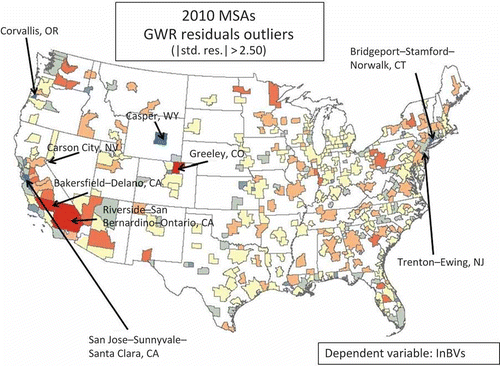
is the map of standardized residuals for MSAs where the BVs are the dependent variable for 2006. is the map of standardized residuals for the MSA scale where the BVs are the dependent variable for 2010. Note that the two maps are very similar. The only difference between 2006 and 2010 are that Casper, Wyoming appears as an outlier in 2010, and Santa Cruz, California does not appear as an outlier. The reverse is true for 2006. All other outliers are the same for both models.
5. Conclusions
The models examined here appear to be mis-specified at all scales, regardless of directionality, perhaps due to missing variable(s) or due to non-linear relationships between the variables. The results found here support conclusions made at other scales, although no other previous studies have examined the relationship at the MSA scale, as was demonstrated here.
The results here strongly suggest that models of the relationship between GDP and the NLs vary by scale, and that the DMSP-OLS stable lights imagery does capture socioeconomic processes occurring at different scales. Based on the results shown here, the MSA scale has a stronger relationship with the NLs over the State scale using this model, and the results at either scale are consistent through time, even if all are miss-specified.
And finally, the results here indicate that GDP appears to predict the NLs at the MSA scale, and not vice versa. The relationship is not as strong at the State scale for this model, and therefore not appropriate for prediction using this model.
The results also show that the MSA spatial extent is statistically more significant over the State spatial extent using this model. This suggests that secondary sub-national aggregated spatial units may correlate well in other regions or nations, and this could be tested. The results here also support other conclusions made that non-MSA (rural) area economic statistics are not well described by the NL data, which also directs us to conclude that any model of socioeconomic statistics with the NL should vary by scale. Until the model is well specified, the model cannot be tested for scaling.
Correlation at either spatial extent holds through time, suggesting that the variables are appropriate for a time series investigation with the appropriately well-described models. Well-described scaled models would greatly inform investigations for multi-scale, multi-temporal change-detection studies. It is believed that time series analysis would contribute to defining a well-described model.
Not surprisingly, the majority of outliers at the MSA extent are densely populated areas (Figures 6 and 7). However, not all densely populated areas are outliers and not all outliers are densely populated. The results do suggest, however, that population or per capita GDP, in some form, plays a role in a well-specified model at the examined scales.
A secondary investigation to compare MSA correlation within states or within regions in the United States would be appropriate. Forbes (Citation2011) showed that MSA correlation was very high in Florida. The national-level results show that the strength of correlation decreases when applied for all MSAs in the contiguous United States and yet the GWR results show relatively little improvement over non-spatial OLS regression (). Examining and comparing correlations between aggregated MSAs not based on proximity may increase our understanding of the relationship between the NL data and GDP in the United States.
The DMSP-OLS satellite system lacks onboard calibration. The 2006 NL data was collected by a different sensor (F16 sensor) than the 2010 NL data (F18 sensor). The results shown here are subject to possible sensor-related differences, because the two images used in this study were not inter-calibrated. Further time series analysis should address inter-calibration between sensors.
This analysis would benefit by repeating the method using population statistics instead of GDP. Further investigations are needed to identify and describe well-specified models between the NLs and socioeconomic statistics at all scales. Time series analysis may be necessary in establishing process-response in the variables, which reiterates the need for inter-calibration between yearly average images.
A well-described model of the processes captured by the DMSP-OLS combined with time series analysis might then assist us in examining global, regional, or local causal relationships between economic activity and energy use, among many other possible investigations. Understanding the spatial and temporal relationship between economic activity and energy use in the United States would then certainly contribute to the ongoing discussion regarding issues of sustainability in the United States.
Acknowledgments
Warmest thanks to Dr Tobin Hindle, Dr Russell Ivy, Dr Jorge Restrepo, Dr Charles Roberts, and Dr Zhixiao Xie for their valuable comments on the draft manuscript and to the anonymous reviewers for their significant improvements to the manuscript. Additional thanks go to Dr Scott Markwith for his thesis idea that has been the “gift that keeps on giving.” This project is supported by the National Aeronautics and Space Administration through the University of Central Florida's NASA Florida Space Grant Consortium.
Related Research Data
References
- Amaral , S. , Camara , G. , Monteiro , A. M. , Quintanilha , J. A. and Elvidge , C. D. 2005 . Estimating Population and Energy Consumption in Brazilian Amazonia Using DMSP Night-Time Satellite Data . Computers, Environment and Urban Systems , 29 ( 2 ) : 179 – 195 .
- Balk , D. L. , Deichmann , U. , Yetman , G. , Pozzi , F. and Hay , S. I. 2006 . Determining Global Population Distribution: Methods, Applications and Data . Advances in Parasitology , 62 : 119 – 156 .
- Cash , D. W. , Adger , W. N. , Berkes , F. , Garden , P. , Lebel , L. , Olsson , P. , Pritchard , L. and Young , O. 2006 . Scale and Cross-Scale Dynamics: Governance and Information in a Multilevel World . Ecology and Society , 11 ( 2 ) : 8
- Chand , T. R. K. , Badarinah , K. V. S. , Elvidge , C. D. and Tuttle , B. T. 2009 . Spatial Characterization of Electrical Power Consumption Patterns over India Using Temporal DMSP-OLS Night-Time Satellite Data . International Journal of Remote Sensing , 30 ( 3 ) : 647 – 661 .
- Doll, C. N. H., J. G. Morley, and J.-P. Muller. 2004. “Geographic Information Issues Associated with Socio-Economic Modeling from Night-Time Light Remote Sensing Data.” In Proceedings of the XXth ISPRS (1–6), Presented at the Proceedings of the XXth ISPRS. Istanbul: ISPRS.
- Doll , C. N. H. , Muller , J.-P. and Elvidge , C. D. 2000 . Night-Time Imagery as a Tool for Global Mapping of Socioeconomic Parameters and Greenhouse Gas Emissions . AMBIO: A Journal of the Human Environment , 29 ( 3 ) : 157 – 162 .
- Doll , C. N. H. , Muller , J.-P. and Morley , J. G. 2006 . Mapping Regional Economic Activity from Night-Time Light Satellite Imagery . Ecological Economics , 57 : 75 – 92 .
- Ebener , S. , Murray , C. , Tandon , A. and Elvidge , C. C. 2005 . From Wealth to Health: Modeling the Distribution of Income Per Capita at the Sub-national Level Using Night-time Light Imagery . International Journal of Health Geographics , 4 ( 5 ) : 5– – 14 .
- Elvidge , C. D. , Baugh , K. E. , Dietz , J. B. , Bland , T. , Sutton , P. C. and Kroehl , H. W. 1999 . Radiance Calibration of DMSP-OLS Low-Light Imaging Data of Human Settlements . Remote Sensing of the Environment , 68 : 77 – 88 .
- Elvidge , C. D. , Baugh , K. E. , Hobson , V. R. , Kihn , E. A. , Kroehl , H. W. , Davis , E. R. and David , C. 1997 . Satellite Inventory of Human Settlements Using Nocturnal Radiation Emissions: A Contribution for the Global Toolchest . Global Change Biology , 3 ( 5 ) : 387 – 395 .
- Elvidge , C. D. , Baugh , K. E. , Kihn , E. A. , Kroehl , H. W. and Davis , E. R. 1997 . Mapping City Lights with Nighttime Data from the DMSP Operational Linescan System . Photogrammetric Engineering & Remote Sensing , 63 ( 6 ) : 727 – 734 .
- Elvidge , C. D. , Baugh , K. E. , Kihn , E. A. , Kroehl , H. W. , Davis , E. R. and Davis , C. W. 1997 . Relation Between Satellite Observed Visible-Near Infrared Emissions, Population, Economic Activity and Electric Power Consumption . International Journal of Remote Sensing , 18 ( 6 ) : 1373 – 1379 .
- Elvidge, C. D., K. E. Baugh, J. Safran, B. T. Tuttle, A. T. Howard, P. J. Hayes, J. Jantzen, and E. H. Erwin. 2005. “Preliminary Results from Nighttime Lights Change Detection.” Conference Paper presented at the Joint Symposia URBAN – URS 2005, Tempe, AZ, March 14–16, edited by M. Moeller, E. Wentz. http://www.isprs.org/proceedings/XXXVI/8-W27/elvidge.pdf (http://www.isprs.org/proceedings/XXXVI/8-W27/elvidge.pdf) (Accessed: 22 July 2013 ).
- Elvidge , C. D. , Imhoff , M. L. , Baugh , K. E. , Hobson , V. R. , Nelson , I. , Safran , J. , Dietz , J. B. and Tuttle , B. T. 2001 . Night-time Lights of the World: 1994–1995 . Photogrammetry & Remote Sensing , 56 ( 2 ) : 81 – 99 .
- Forbes , D. J. 2011 . Statistical Correlation Between Economic Activity and DMSP-OLS Night Light Images in Florida . Papers of the Applied Geography Conferences , 34 : 251 – 266 .
- Ghosh , T. , Anderson , S. , Powell , R. L. , Sutton , P. C. and Elvidge , C. D. 2009 . Estimation of Mexico's Informal Economy and Remittances Using Nighttime Imagery . Remote Sensing , 1 : 418 – 444 .
- Gibson , C. C. , Ostrom , E. and Ahn , T. K. 2000 . The Concept of Scale and the Human Dimensions of Global Change: A Survey . Ecological Economics , 32 ( 2 ) : 217 – 239 .
- Howitt , R. 1998 . Scale as Relation: Musical Metaphors of Geographical Scale . Area , 30 (1) : 49 – 58 .
- Howitt , R. 2002 . Scale and the Other: Levinas and Geography . Geoforum , 33 : 299 – 313 .
- Kramer , H. J. 1994 . Observation of the Earth and Its Environment: Survey of Missions and Sensors , 2nd ed , Berlin : Springer-Verlag .
- Propastin , P. and Kappas , M. 2012 . Assessing Satellite-Observed Nighttime Lights for Monitoring Socioeconomic Parameters in the Republic of Kazakhstan . GIScience & Remote Sensing , 49 ( 4 ) : 538 – 557 .
- Sayre , N. F. 2005 . Ecological and Geographical Scale: Parallels and Potential for Integration . Progress in Human Geography , 29 ( 3 ) : 276 – 290 .
- Sayre , N. F. 2009 . “ Scale.” . In A Companion to Environmental Geography , Edited by: Castree, , N. , Demeritt , D. , Liverman, , D. and Rhoads , B. 95 – 108 . Malden , MA : Blackwell Publishing .
- Small , C. , Pozzi , F. and Elvidge , C. D. 2005 . Spatial Analysis of Global Urban Extent from DMSP-OLS Night Lights . Remote Sensing of Environment , 96 : 277 – 291 .
- Stronge , W. B. 2008 . The Sunshine Economy , Gainesville : University Press of Florida .
- Sutton , P. 1997 . Modeling Population Density with Night-time Satellite Imagery and GIS . Computers, Environment and Urban Systems , 21 ( 3–4 ) : 227 – 244 .
- Sutton , P. 2003 . A Scale-adjusted Measure of ‘Urban Sprawl’ Using Nighttime Satellite Imagery . Remote Sensing of Environment , 86 ( 3 ) : 353 – 369 .
- Sutton , P. C. and Costanza , R. 2002 . Global Estimates of Market and Non-market Values Derived from Nighttime Satellite Imagery, Land Cover, and Ecosystem Service Valuation . Ecological Economics , 41 ( 3 ) : 509 – 527 .
- Sutton , P. , Roberts , D. , Elvidge , C. and Baugh , K. 2001 . Census from Heaven: An Estimate of the Global Human Population Using Night-time Satellite Imagery . International Journal of Remote Sensing , 22 ( 16 ) : 3061 – 3076 .
- Sutton , P. , Roberts , D. , Elvidge , C. and Meij , H. 1997 . A Comparison of Nighttime Satellite Imagery and Population Density for the Continental United States . Photogrammetric Engineering & Remote Sensing , 63 ( 11 ) : 1303 – 1313 .
- Tobler , W. R. 1970 . A Computer Movie Simulating Urban Growth in the Detroit Region . Economic Geography , 46 : 234 – 240 .