Abstract
A novel image registration method is proposed based on the scale-invariant feature transform (SIFT). Our approach combines the image frequency spectrum with a regular grid. The method exploits features of SIFT, the greater number of feature points in high-frequency areas of an image and regular grid traits with a fine spatial distribution to extract evenly distributed feature points. Global correspondence error checking is used to remove false matching pairs. The registration of eight groups of remote sensing images shows that our method has well-distributed feature points in the spatial and scale domains, obtains an average of 15.78% matching pairs more than uniform robust (UR)-SIFT, and provides better registration accuracy than SIFT and UR-SIFT.
1. Introduction
Image registration is the process of overlaying two or more images of the same scene taken at different times from different viewpoints and/or by different sensors (Zitová and Flusser Citation2003). It is a vital step in remote image analysis, which includes remote image fusion (Yang, Kim, and Madden Citation2012; Yu et al. Citation2012), environmental surveillance, change detection (Jensen and Lulla Citation1987), and so on and has been studied by the professionals in the field of remote sensing image processing for several decades. With the rapid development of computer technology, aerospace engineering, and remote sensing techniques, remote sensing images can now provide hyper-spectral, high-resolution, and multi-source data that give a more exhaustive and accurate description of the characteristics of terrain objects (Zhang et al. Citation2005; Goncalves, Corte-Real, and Goncalves Citation2011). Thus, there is a high data volume, more local distortions, and control points. This greatly influences the accuracy and speed of registration (Hong and Zhang Citation2008).
Many automated remote sensing registration methods have been proposed. These methods fall into two main categories ():
| 1. | Area-based methods: These can be divided into methods that use image pixel values directly, including cross-correlation (Bamea et al. 1972) and mutual information (Chen, Varshney, and Arora Citation2003; Kern and Pattichis Citation2007), and those that use the frequency domain, including fast Fourier transform-based methods (Reddy and Chatterji Citation1996). Although most area-based methods have high positional accuracy, they require initial matching positions that can be easily affected by illumination differences. And they have a large amount of calculation. | ||||
| 2. | Feature-based methods: These methods extract and match salient features from two images. They are divided into methods that use low-level image features, such as edges (Hsu and Beuker Citation2002), corners (Wang et al. Citation1983), contours (Li, Manjunath, and Mitra Citation1995), lines (Medioni and Nevatia Citation1984), and regions (Goshtasby, Stockman, and Page Citation1986) from the images, and methods that use higher-level structural and syntactic descriptors (Brown Citation1992), including the scale-invariant feature transform (SIFT) (Lowe Citation1999, Citation2004) and speed-up robust features (Bay, Tuytelaars, and VanGool Citation2008). The form of the descriptor, as well as the type of feature used for matching, depends on the task to be performed. Compared with area-based methods, feature-based methods are more robust and more reliable, but they are usually less accurate and have eliminating mismatched pairs issue. | ||||
Because of its invariance to image scaling and rotation and its partial invariance to illumination and camera viewpoint changes, SIFT has been successfully applied to the registration of remote sensing images. SIFT's descriptor is also considered to perform better than similar descriptors (Mikolajczyk and Schmid Citation2005). Therefore, there are a number of SIFT-based methods. To improve the computational performance of feature matching, Yan and Rahul (Citation2004), Duan et al. (Citation2008), and Liu et al. (Citation2010) employed principal component analysis, independent component analysis, and kernel independent component analysis, respectively, to remove high-order redundant information in the SIFT descriptors. El Rube, Sharks, and Salem (Citation2009) combined SIFT and wavelet theory to reduce the computational load, and Mikolajczyk and Schmid (Citation2005) presented a new gradient location and orientation histogram to make SIFT's descriptor more unique and robust. Morel and Yu (Citation2009) also developed an improved method, ASIFT, to resolve the incomplete affine element of SIFT's descriptor. However, SIFT's strategy of selecting feature points is only based on a threshold of the contrast value and the ratio of principal curvatures, and it does not have the ability to control the distribution or quantity of feature points. There are a limited number of methods for resolving the distribution of SIFT feature points, which may lead to poor registration accuracy when there is local distortion with few feature points. Although Sedaghat, Mokhtarzade, and Ebadi (Citation2011) developed a uniform robust (UR)-SIFT to improve the distribution of feature points, their method rarely obtains sufficient feature points of each scale to ensure scale invariance. Moreover, when SIFT-based methods are adopted to align remote sensing images, numerous false matches appear and registration accuracy is greatly reduced.
To addresses the uneven distribution problem of SIFT and the inadequate number of feature points in UR-SIFT, we propose a novel remote sensing registration method based on the frequency spectrum of an image and a regular grid (FS-G-SIFT) in this article. This method first uses SIFT and the combination of an image frequency spectrum and a regular grid to detect well-distributed feature points. Global correspondence error checking is then utilized to eliminate false matching pairs. FS-G-SIFT has high-quality features with a good distribution in both the scale and spatial domains and can be applied to various types of remote sensing images with wide ranges of scale, rotation, translation, illumination, and viewing point differences.
Table 1. Summary of the area-based and feature-based registration methods
Table 2. Details of the data sets in the experiments
Table 3. Feature point detection results and matching results for data sets in Table 2
Table 4. Comparison results of RMSEtest and RT for data sets in Table 2
Figure 1. Flowchart of FS-G-SIFT.
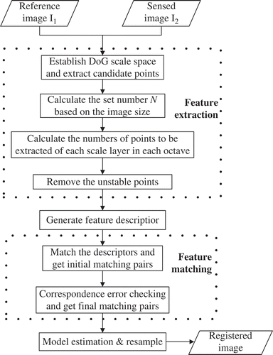
Figure 2. R d_correct results for different values of the total desired number N.
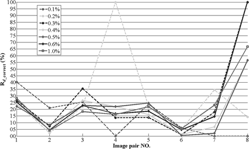
Figure 3. RMSEtest comparison for the image pairs in among SIFT, UR-SIFT, and FS-G-SIFT.
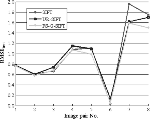
Figure 4. Matching results for two TerraSAR-X satellite images in Table 2.
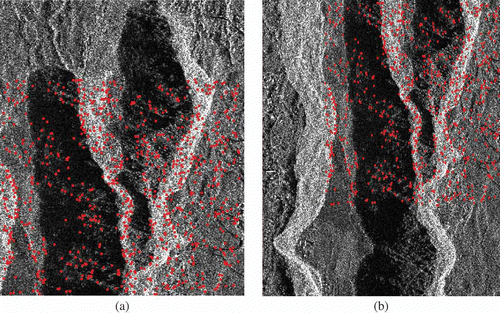
Figure 5. Matching results for two WorldView-II satellite images in Table 2.
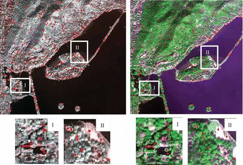
Figure 6. Matching results for two IKONOS and SPOT5 satellite images in Table 2.
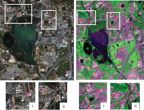
Figure 7. Registration results of three image pairs in .
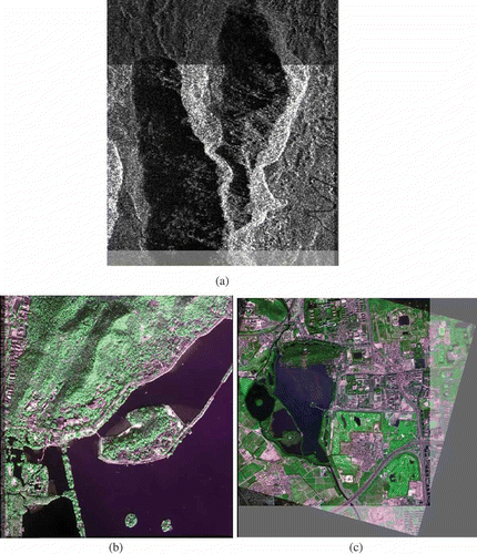
Figure 8. Nonuniform distribution of SIFT feature points for an IRS Image (900 × 900 pixels).
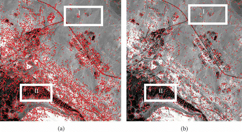
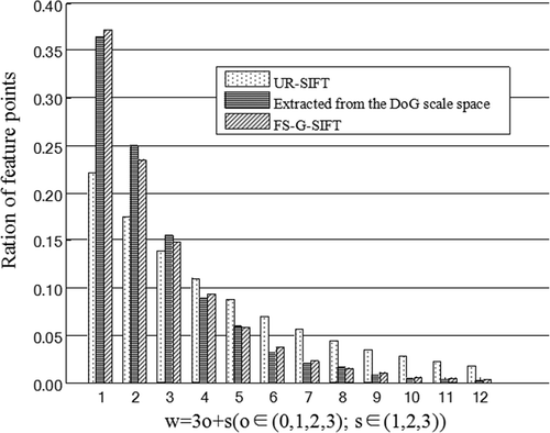
Figure 9. Ratio comparison of feature points in the scale domain for UR-SIFT, FS-G-SIFT, and candidate keypoints extracted from the DoG scale space for a WorldView-II satellite image (B 4/3/2) of Hangzhou, China.
2. Methods
2.1. Problems with SIFT and UR-SIFT
SIFT was proposed by Lowe in Citation1999 and completed in Citation2004. It is well known that SIFT is invariant to image scaling and rotation and partially invariant to illumination and camera viewpoint changes. UR-SIFT (Sedaghat, Mokhtarzade, and Ebadi Citation2011) was intended to improve the distribution of feature points of SIFT. Despite its outstanding characteristics, SIFT cannot obtain well-distributed feature points in the spatial or scale domains when applied to the registration of remote sensing images. Although UR-SIFT can improve the distribution of feature points, it does not always obtain an adequate number of points at some scales. These problems are now discussed in greater detail.
2.1.1. The uneven distribution problem of SIFT
The quantity, quality, and distribution of feature points determine the accuracy and reliability of remote sensing image registration. A relatively uniform distribution of feature points is essential for accurate piecewise transformation when there are local distortions in remote sensing images.
Despite the outstanding characteristics of SIFT, it cannot obtain an even distribution of feature points in the spatial or scale domains when applied to the registration of remote sensing images. As a precondition that there must be enough feature points in different scale layers, SIFT can be invariant to scale change. Although SIFT can extract many candidate keypoints, it only preserves stable ones that satisfy some threshold of the contrast value and the ratio of principal curvature. Therefore, SIFT cannot control both the total number of feature points and their number in different scale layers. That is, it lacks control over the quantity and distribution of feature points.
2.1.2. The insufficient points problem of UR-SIFT
Although UR-SIFT can improve the distribution of feature points, there are still some shortcomings. UR-SIFT uses a linear proportion to improve the distribution of feature points in the scale domain, but the proportion does not correspond to that of the candidate keypoints actually extracted from the difference-of-Gaussian (DoG) scale space. As a result, the required keypoints cannot be satisfied when the image layers possess large scale factors.
2.2. FS-G-SIFT
The proposed FS-G-SIFT initially uses feature point extraction to obtain a controllable number of well-distributed and stable feature points for remote sensing images. This is followed by global correspondence error checking. A flowchart of FS-G-SIFT is presented in , and the following subsections discuss the details of each module.
2.2.1. Scale-space generation
First, FS-G-SIFT constructs the DoG scale space of an image (Lowe Citation2004). The Laplacian of Gaussian (LoG) scale space of an image, consisting of several octaves of blurred image layers, is constructed by the convolution of an image with a variable scale Gaussian function
. For each octave, the first image is repeatedly convolved with Gaussian kernels with a constant multiplicative factor
. This obtains different blurred images forming an octave. An image with twice the scale of the first in the previous octave is down-sampled by a factor of two as the first image in the next octave. The difference of two nearby scales separated by a constant factor
is then defined as the DoG. By approximating the Laplacian function with its DoG function, this step can efficiently detect feature points.
The scale factor of the sth scale layer in the oth octave can be computed as follows:
Candidate keypoints are then obtained from the DoG scale space by detecting local maxima and minima of . A point is selected only if it is larger or smaller than its eight neighbors in the current image and 18 neighbors in the neighboring (higher and lower) scales. This guarantees that the candidate keypoints are extrema in both the spatial and scale domains.
2.2.2. Numbers of feature points to be extracted
According to signal processing theory, the convolution of the Gaussian function and 2D image
in the spatial domain, whose result is a smoothed low-frequency image, corresponds to the product of their Fourier transforms in the frequency domain.
It can be observed that the Fourier transform of the Gaussian function is also a Gaussian function and that a greater variance in gives a smaller variance in
. Characterizing the width of the Gaussian function, larger values of parameter
in
will give a narrower
and a smoother image.
Hence, based on the process of scale-space generation, it can be determined that the LoG scale space consists of images with different low-frequency components. As the octave and layer
increase, the variable scale factor
increases and more high-frequency components are filtered. The DoG function is an approximation of the LoG function, so the DoG scale space possesses a similar frequency spectrum to the LoG scale space. In addition, feature points represent salient characteristics of the image, belonging to high-frequency components. Thus, the more high-frequency components there are in an image, the more feature points there will be. In other words, the number of feature points increases as the variable scale factor
decreases.
Based on the above analysis, the scale-space distribution problem is addressed by assigning an appropriate number of feature points to each scale layer. This number is proportional to the scale factor of that layer. Owing to the smoothing characteristics of the DoG scale space, the number of feature points in each scale layer should be inversely proportional to the square of the scale factor. If it is intended that feature points are selected from the DoG scale space, the number of required feature points in the sth scale layer of the oth octave and the first scale layer of the first octave are denoted by
and
, respectively. We thus have
Substituting Equations (1) and (5) into EquationEquation (6), we obtain
Finally, based on Equations (6) and (7),
This guarantees a reasonable number of feature points in each scale layer whose ratios are similar to the candidate keypoints actually extracted from the DoG scale space, thus creating a suitable environment for scale invariance.
Furthermore, the spatial distribution problem of feature points is addressed by applying regular grids to each image layer and determining the desired number of feature points in each grid from the amount of information. The average gradient, number of actual candidate keypoints, and mean contrast of a grid are used to measure how much information it contains. The average gradient reflects the gray-change rate of an image and the expressive power of the image detail contrast, which is represented by
2.2.3. Accurate localization
After setting the number of feature points to be extracted in each scale layer and every grid, unstable points should be removed to obtain the desired number of stable feature points.
As the candidate keypoints from 2D discrete space are not necessarily real extrema, they are relocated using Taylor's interpolation equation. Unstable points are rejected when the absolute DoG values of their interpolations are less than 0.03 or when their ,
, or
interpolation offsets exceed 0.5 (Lowe Citation2004). In addition, points close to edges are unstable and should be discarded because they have a larger principal curvature across the edge but a small one in the vertical direction. There is also a proportional relationship between the eigenvalue of the 2 × 2 Hessian matrix
of each keypoint and its principal curvature. Hence, unstable points whose
eigenvalue ratio is greater than a threshold of 10 are removed (Lowe Citation2004).Finally, the feature point extraction of FS-G-SIFT can be described as follows:
Algorithm 1: Feature point exatrction
Input:
(the original image),
(the desired feature points).
Output: (the extracted feature points).
1: Establish the DoG scale space of and extract its candidate keypoints;
2: Calculate the desired number of each scale layer in each octave;
3:
for
to
do
4:
for
to
do
5: Use a regular mesh to grid the sth image layer;
6: Calculate the desired number of grids in the sth image layer;
7: For each grid in the sth image layer;
8: Precisely locate the candidate keypoints and calculate their contrast ;
9: Keep the greatest value of in the candidate keypoints, and remove the rest;
10: Remove keypoints whose principal curvature ratio is greater than a threshold value of 10;
11: Keep candidate keypoints with the greatest contrast values;
12: end for
13: end for
14: Obtain the extracted feature points .
2.2.4. Global correspondence error checking
After obtaining the original SIFT descriptors of the reference and sensed images, the ratio between the closest and second-closest neighbors of the target descriptor is exploited to obtain matching pairs. This is likely to yield false matching pairs and reduce the registration accuracy (Yu, Zhang, and Holden 2008). Global correspondence error checking is utilized to eliminate false matching pairs in this article. Based on a known global affine transformation model and a threshold of the root mean square error (RMSE), matching pairs with the greatest variance are regarded as false and are eliminated. This step is repeated until the RMSE of the remaining pairs is smaller than the threshold. A final transformation model is then solved by the remaining matching pairs. The global affine transformation model can be expressed by
Here, the RMSE, defined as RMSEcheck, is taken as a measure of whether a matching pair is false:
Algorithm 2: Global correspondence error checking
Input:
(number of matching pairs),
(matching pairs),
(threshold of RMSE),
(initial transformation model).
Output:
(correct matching pairs).
1: Calculate the variance of each matching pair ;
2: Calculate the of the matching pairs;
3: While
and
4: find the greatest and eliminate it;
5:
←
;
6: calculate the of the remaining matching pairs;
7: Obtain the correct matching pairs
2.3. Evaluation criteria
Several criteria are also adopted to quantitatively evaluate the method:
| 1. | Number of feature points and correct matching pairs: the number of feature points from the reference image and sensed image in each pair of the above data sets and the number of matching pairs are recorded. The ratio of the mismatched pairs (Rmis) is also used here. | ||||
| 2. | RMSEtest: This is widely used by many researchers to determine the registration accuracy. Some 10 test-point pairs selected manually for each test case cannot be set to zero by overfitting. Given the two point sets, their RMSE is calculated by EquationEquation (12) | ||||
| 3. | Running time (RT): defined as the execution time needed by the detection and matching scheme to complete the task. All experiments are performed on an Intel Core 2 6600 (2.40 GHz processor) with 3.25 GB of physical memory using the VS2008 compiler. | ||||
| 4. | Rd_correct: the ratio of the difference in the number of correct matching pairs between FS-G-SIFT and UR-SIFT to the number of correct matching pairs from FS-G-SIFT: | ||||
3. Experimental data
Three datasets (containing different scenes, different scales or rotations, and different sensors, respectively) are used to systematically test the robustness of our approach. Their details are presented in :
| 1. | Data set 1: a pair of images acquired by the same sensor of TerraSAR-X with different scenes. Considering the small scene differences, a good image registration result can be expected (http://www.dlr.de/desktopdefault.aspx/tabid-4237/6774_read-18112/). | ||||
| 2. | Data set 2: five sets of the same sensor image pairs, acquired by four different satellite sensors. They are all false-color images combining three different bands. To validate the invariance of FS-G-SIFT to scale, tests are performed on a pair of multi-spectral SPOT5 satellite images and a pair of WorldView-II satellite images, where there are scale differences (0.8) between the reference and sensed images. Another two tests on multi-spectral IKONOS and QuickBird satellite images with rotation differences (10°) are used to verify the invariance of FS-G-SIFT to rotation. Two panchromatic SPOT5 satellite images with both scale (0.8) and rotation (10°) differences are also tested. | ||||
| 3. | Data set 3: two pairs of images acquired by different sensors (QuickBird and SPOT5, SPOT5 and IKONOS) at different times. These have big differences in their gray values, aspect angles, and scales. Two multi-spectral SPOT5 images are, respectively, matched with a multi-spectral IKONOS and a multi-spectral QuickBird image, all of which are pseudo-color images. | ||||
4. Results and discussion
In this section, the performance of FS-G-SIFT is experimentally verified and is compared with that of the original SIFT (Lowe Citation2004) and UR-SIFT (Sedaghat, Mokhtarzade, and Ebadi Citation2011).
4.1. Experimental results
In all of our experiments, following Lowe (Citation2004) and Sedaghat Mokhtarzade, and Ebadi (Citation2011), we use ,
(Section 2.2), and a 100 × 100 regular grid. To attain a high registration accuracy, the threshold of RMSEcheck (Section 2.2), used to eliminate false matching pairs, is set to
. The weight parameters (Section 2.2) are empirically determined as
.
Three data sets () are tested for different desired numbers of feature points. As can be seen from R
d_correct comparison on condition that the total desired number of feature points are set to be different, shown in , R
d_correct is greater than zero for all values of N is, which indicates that FS-G-SIFT obtains more matching pairs than UR-SIFT. When the desired number is set to be 0.4% of the image size, there are no abnormal values, and the number of matching pairs in each test is neither too small nor too large. Thus, the desired number of total feature points is set to 0.4% of the image size in the following experiments.
As observed from the feature point detection and matching results in , the original SIFT obtains the most feature points and matching pairs. The number of feature points detected by FS-G-SIFT is greater than that detected by UR-SIFT and closer to the set numbers. FS-G-SIFT also found more matching pairs than that in UR-SIFT. And the average increment of correct matching pairs (R d_correct) is 15.78%, as shown in . We can see that only certain scenes difference in the first test, and the high resolution in No. 6 cause higher numbers of feature points and matching pairs to be found. Although there are many feature points in No. 7 and No. 8, the number of matching pairs is very small owing to the large geometrical distortions of the multi-sensor images. In addition, the R mis value of FS-G-SIFT is much lower than that of SIFT, which indicates that there are fewer false matching pairs because of the global correspondence error checking.
The quantitative RMSEtest and RT results are given in , and shows the line graph of RMSEtest. It can be seen that the RMSEtest values for both SIFT and UR-SIFT are higher than that from FS-G-SIFT. This indicates that FS-G-SIFT has a better registration accuracy. RT measures the processing time of detecting feature points, generating feature descriptors, and matching features. The RT of FS-G-SIFT is close to that of SIFT and UR-SIFT.
Matching results for No. 1, No. 3, and No. 7 () are presented in –, and their registration results are illustrated in . As can be seen from , there are many matching feature points in the overlapping region of the two images, whereas there are no feature points in the non-overlapping region of the two images. The number of false matching pairs is reduced by the corresponding error check. From , we can see that feature points are well-distributed, and the matching pairs are also exactly matched in region-I and region-II. shows that although there are scale, rotation, and illustration changes, the matching pairs in region-I and region-II are accurate.
Hence, it can be seen that FS-G-SIFT is well able to register TerraSAR-X, multi-spectral, and multi-sensor images. The experimental results allow further conclusions to be drawn:
| 1. | On account of the well-distributed points in the scale and spatial domain, FS-G-SIFT has better registration accuracy than SIFT and UR-SIFT. By this means, the total number of feature points and their distribution can be controlled. | ||||
| 2. | There are fewer feature points and matching pairs obtained from FS-G-SIFT than from SIFT, which will decrease the time required to generate feature descriptors and match features. The running time for detecting well-distributed feature points is not a burden. | ||||
| 3. | The number of feature points detected by FS-G-SIFT is greater than that by UR-SIFT and is closer to the set number. This verifies the effectiveness of FS-G-SIFT in solving the inadequate number problem of UR-SIFT. | ||||
| 4. | Owing to the global correspondence error checking, FS-G-SIFT produces far fewer false matching pairs than SIFT. | ||||
4.2. Discussion
Experiments on different images with different transforms have shown that FS-G-SIFT can obtain better image registration accuracy than the original SIFT and UR-SIFT while maintaining the running time. It also can extract well-distributed feature points in both the spatial domain and the scale domain. We now take a closer look at the method and conduct some tests that help explain FS-G-SIFT's success.
A comparison ( and ) of the spatial distribution of feature points detected by SIFT and FS-G-SIFT for an IRS image (http://www.satimagingcorp.com/gallery/irs-omen.html) verifies the better spatial distribution of feature points from FS-G-SIFT. The feature points in regions I and II () indicate that there are neither too few nor too many feature points from our method, which cannot lead to an inaccurate registration result when there are local deformations or a large amount of calculation. This mainly results from the setting number of feature points in each grid, which is based on the grid's image information (Section 2.2). Hence, our method is especially appropriate to the remote sensing images with local deformations.
Compared with UR-SIFT, we show that FS-G-SIFT obtains more feature points and matching pairs (), which profits from the proper scale ratios based on the frequency spectrum of image layer from the DoG scale space (Section 2.2). The setting number of each scale from FS-G-SIFT is less than the candidate feature points extracted from DoG scale space (). Thus, FS-G-SIFT can obtain the sufficient feature points in each scale and its characteristics of scale invariance are more robust, which guarantees the registration accuracy.
However, only the image size is used to control the number of feature points in this article. Image texture and other information that may affect the detection of feature points should be included, which will increase the computational complexity.
5. Conclusions
The main contribution of this article is a strategy for detecting evenly distributed feature points for SIFT. We draw on a combination of the image frequency spectrum and regular grids to obtain well-distributed feature points in both the scale domain and the spatial domain. Our image registration scheme is especially appropriate for images with many local deformations. Compared with UR-SIFT, FS-G-SIFT obtained more feature points and matching pairs. The experimental results show that FS-G-SIFT has better image registration accuracy than two different related methods (SIFT and UR-SIFT).
Acknowledgments
The authors thank Libao Zhang who is an associate professor at the College of Information Science and Technology at Beijing Normal University for his advice and comments. The authors thank the anonymous reviewers for their constructive comments, which substantially improved the quality of this article. This work was supported by the National Natural Science Foundation of China (No. 41272359, 41072245, 11001019), the Specialized Research Fund for the Doctoral Program of Higher Education of China (No. 20120003110032), and the Fundamental Research Funds for the Central Universities of China (No. 2012LZD05).
Notes
Related Research Data
References
- Bay , H. , Tuytelaars , T. and Van Gool , L. 2008 . Speeded-up Robust Features (SUFR) . Computer Vision and Image Understanding , 110 ( 3 ) : 346 – 359 .
- Bamea , D. I. and Silverman , H. F. 1972 . A Class of Algorithms for Fast Digital Image Registration . IEEE Transactions on Computers , 21 ( 2 ) : 179 – 186 .
- Brown , L. G. 1992 . A Survey of Image Registration Techniques . ACM Computing Survey , 24 : 325 – 376 .
- Chen , H. , Varshney , P. and Arora , M. 2003 . Mutual Information Based Image Registration for Remote Sensing Data . International Journal of Remote Sensing , 24 ( 18 ) : 3701 – 3706 .
- Duan , C. , Meng , X. , Tu , C. and Yang , C. 2008 . How to Make Local Image Features More Efficient and Distinctive . IET Computer Vision , 2 ( 3 ) : 178 – 189 .
- El Rube , I. A. , Sharks , M. A. and Salem , A. R. September 28--30 2009 . “ Image Registration Based on Multi-scale SIFT for Remote Sensing Images ” . In Proceedings of the Third International Conference on Signal Processing and Communication Systems (ICSPCS) September 28--30 , 1 – 5 . Omaha , NE
- Goncalves , H. , Corte-Real , L. and Goncalves , J. A. 2011 . Automatic Image Registration through Image Segmentation and Sift . IEEE Transactions on Geoscience and Remote Sensing , 49 ( 7 ) : 2589 – 2600 .
- Goshtasby , A. , Stockman , G. and Page , C. 1986 . A Region-Based Approach to Digital Image Registration with Subpixel Accuracy . IEEE Transactions on Geoscience and Remote Sensing , 24 : 390 – 399 .
- Hong , G. and Zhang , Y. 2008 . Wavelet-Based Image Registration Technique for High-Resolution Remote Sensing Images . Computers & Geosciences , 34 : 1708 – 1720 .
- Hsu , C. and Beuker , R. 2002 . Multiresolution Feature-Based Image Registration . Proceeding of SPIE—Visual Communications and Image Processing , 4067 : 1490 – 1498 .
- Jensen , J. R. and Lulla , K. 1987 . Introductory Digital Image Processing: A Remote Sensing Perspective . Geocarto International , 2 ( 1 ) : 65 – 65 . doi: 10.1080/10106048709354084.
- Kern , J. P. and Pattichis , M. S. 2007 . Robust Multispectral Image Registration Using Mutual-Information Models . IEEE Transactions on Geoscience and Remote Sensing , 45 ( 5 ) : 1494 – 1505 .
- Li , H. , Manjunath , B. and Mitra , S. 1995 . A Contour-Based Approach to Multi-Sensor Image Registration . IEEE Transactions on Image Processing , 4 ( 3 ) : 320 – 334 .
- Liu , X. Z. , Tian , Z. , Leng , C. C. and Duan , X. F. August 10–12 2010 . “ Remote Sensing Image Registration Based on KICA-SIFT Descriptors ” . In Proceedings of the Seventh International Conference on Fuzzy Systems and Knowledge Discovery, Yantai , Vol. 1 , August 10–12 , 278 – 282 . Piscataway , NJ : IEEE Computer Society .
- Lowe , D. G. September 20–27 1999 . “ Object Recognition from Local Scale-invariant Features ” . In International Conference on Computer Vision, Kerkyra , Vol. 2 , September 20–27 , 1150 – 1157 . Piscataway , NJ : IEEE Computer Society .
- Lowe , D. G. 2004 . Distinctive Image Features from Scale-Invariant Keypoints . International Journal of Computer Vision , 60 ( 2 ) : 91 – 110 .
- Medioni , G. and Nevatia , R. 1984 . Matching Images Using Linear Features . IEEE Transactions on Pattern Analysis and Machine Intelligence , 6 : 675 – 685 .
- Mikolajczyk , K. and Schmid , C. 2005 . A Performance Evaluation of Local Descriptors . IEEE Transactions on Pattern Analysis and Machine Intelligence , 27 ( 10 ) : 1615 – 1630 .
- Morel , J. M. and Yu , G. S. 2009 . ASIFT: A New Framework for Fully Affine Invariant Image Comparison . Society for Industrial and Applied Mathematics Journal on Image Sciences , 2 ( 2 ) : 438 – 469 .
- Reddy , B. S. and Chatterji , B. N. 1996 . An FFT-Based Technique for Translation, Rotation, and Scale-Invariant Image Registration . IEEE Transactions on Image Processing , 5 : 1266 – 1271 .
- Sedaghat , A. , Mokhtarzade , M. and Ebadi , H. 2011 . Uniform Robust Scale-Invariant Feature Matching for Optical Remote Sensing Images . IEEE Transactions on Geoscience and Remote Sensing , 49 ( 11 ) : 4516 – 4527 .
- Wang , C. Y. , Sun , H. , Yada , S. and Rosenfeld , A. 1983 . Some Experiments in Relaxation Image Matching Using Corner Features . Pattern Recognition , 16 ( 2 ) : 167 – 182 .
- Yan , K. and Rahul , S. 2004 . PCA-SIFT: A More Distinctive Representation for Local Image Descriptors . Proceedings of IEEE International Conference on Computer Vision and Pattern Recognition , 2 : 504 – 513 .
- Yang , B. Y. , Kim , M. and Madden , M. 2012 . Assessing Optimal Image Fusion Methods for Very High Spatial Resolution Satellite Images to Support Coastal Monitoring . GIScience & Remote Sensing , 49 ( 5 ) : 687 – 710 .
- Yu , L. , Zhang , D. R. and Holden , E. J. 2008 . A Fast and Fully Automatic Registration Approach Based on Point Features for Multi-Source Remote-Sensing Images . Computers & Geosciences , 34 : 838 – 848 .
- Yu , X. C. , Ni , F. , Long , S. L. and Pei , W. J. 2012 . Remote Sensing Image Fusion Based on Integer Wavelet Transformation and Ordered Nonnegative Independent Component Analysis . GIScience & Remote Sensing , 49 ( 3 ) : 364 – 377 .
- Zhang , S. Y. , Wang , P. Q. , Chen , X. Y. and Zhang , X. 2005 . A New Method for Multi-Source Remote Sensing Image Fusion . Geoscience and Remote Sensing Symposium , 6 : 3948 – 3951 .
- Zitová , B. and Flusser , J. 2003 . Image Registration Methods: A Survey . Image and Vision Computing , 21 : 977 – 1000 .