
Abstract
Estimating tree characteristics with field plots located in remote and inaccessible areas can be a costly and timely endeavor. Light Detection and Ranging (Lidar) remote sensing allowing for the estimation of the 3-dimensional structure of forest vegetation offers an alternative to traditional ground based forest measurements. This project assessed the utility of using Lidar data to estimate number of trees, tree height and crown width within Barksdale Air Force Base forest management area, Bossier City, Louisiana. Two programs, Lidar Data Filtering and Forest Studies (Tiffs) and Lidar Analyst were used to derive forest measurements, which were compared to field measurements. Based on Root Mean Square Error (RMSE), Lidar Analyst (3.81 trees) performed better than Tiffs (5.71 trees) at estimating average tree count per plot. Tiffs was better at deriving average tree height than Lidar Analyst with an RMSE of 19.08 feet to Lidar Analyst’s RMSE of 21.20 feet. Lidar Analyst, with a RMSE of 25.41 feet, was better in deriving average crown diameter over Tiffs RMSE of 30.54 feet. All linear correlation coefficients between average field measured tree height and Lidar derived average tree height were highly significant at the 0.01 probability level for both Tiffs and Lidar Analyst on hardwood, conifers and a combined hardwood-conifer comparison.
Keywords:
Introduction
Forest products, derived from the timber of harvested trees, are used in daily life from paper and pencils to furniture and musical instruments. The quantification of timber, which a land manager can estimate for a stand of trees, is critical in ascertaining the amount of forest products attainable and is a function of the number of trees available, tree height and tree diameter, which is highly correlated with crown width. The ability to remotely sense tree characteristics from a distance, in an effort to reduce the time and cost of timber cruising, shows promise as an alternative to field measurements.
Light Detection and Ranging (Lidar), which is a relatively new form of remotely sensed data as compared to traditional digital imagery obtained from satellites or an aerial platform, uses laser-scanning to measure the height and elevation of the landscape’s physical attributes. With accurate height data attained remotely, an estimate of individual tree characteristics from a distance is possible. Two software packages available for Lidar extraction and measurement of forest attributes were analyzed for their accuracy in deriving tree characteristics; Toolbox for Lidar Data Filtering and Forest Studies (Tiffs) by Globalidar and Lidar Analyst which is an extension to ArcGIS Desktop. Tiffs is highly automated and fast at generating bare earth models, digital surface models (DMS) and extracting forest information. Lidar Analyst was developed by Visual Learning Systems as a 3-D feature extraction solution for generating elevation models, buildings and tree attributes from Lidar data. The number of trees, tree height and crown width extracted from Lidar data using Tiffs and Lidar Analyst were compared to field collected data to evaluate the accuracy of the two software packages in deriving accurate tree characteristics from a distance.
Background
Timber cruising, the act to locate and estimate the quantity of timber on a given area according to species, size, quality, possible products or other characteristics, has been the method of evaluating forests for decades. Gambill, Wiant, and Yandle (Citation1985) studied the optimum plot size to be cruised and found that the optimum sample plot size increased as tract size increased along with a corresponding decrease in desired probability level. Depending on the quality of preparation, timber cruises can consume up to 21 days to complete depending on the track size.
Remote sensing brings with it the possibility of estimating tree characteristics in inaccessible areas as well as large tracts of forestland. Aerial and satellite remotely sensed data have limitations in estimating timber as spectral reflectance of sub-canopy components such as grass are more reflective than the forest canopy creating negative effects (Trotter, Dymond, and Goulding Citation1997). The near-infrared band correlation between reflectance and biomass may be positive as an open stand with a low overstory leaf area index (LAI) would have higher near-infrared band radiance from understory vegetation and high-reflectance soils creating an influence in the positive direction (Spanner et al. Citation1990). Danson and Curran (Citation1993) found a negative correlation between reflectance and biomass in the near-infrared band attributed to higher levels of penetration and multiple scattering of near infrared radiation within a canopy and high absorption levels of red radiation by vegetation. Franklin (Citation1986) found no clear relationship between the tree characteristic basal area and mid-infrared response variables. De Wulf et al. (Citation1990) demonstrated an improvement in the relationship between basal area and spectral radiance using higher spatial resolution SPOT panchromatic data; however, there was no direct physical link between reflectance of the forest canopy and woody biomass.
Lidar uses either full-waveform or discrete return laser light that strike objects or bare ground on the earth’s surface and determines the return location by measuring the time it takes for the light to return to the sensor. The Lidar laser scanner is typically mounted at the bottom of an aircraft (similar to an aerial camera) along with an Inertial Measuring Unit (IMU) and a global positioning system (GPS) unit. The return time for each pulse is used to calculate distance from the sensor. Along with the GPS data, the geographic coordinates of an object in 3-D space can be determined. The Lidar system requires a surveyed ground-based location to be established in the project area. Lidar scanning can occur day or night, as long as clear flying conditions are present. While both types of Lidar systems gather highly accurate X, Y and Z coordinate data, full waveform Lidar records the entire return signal in a beam of light comprising a continuous waveform, while discrete Lidar only captures return signals at the peaks in the reflected waveform. Discrete return Lidar systems record up to five returns per Lidar pulse as it penetrates beyond the first reflective surface of a vegetative canopy. It is capable of distinguishing not only the forest canopy and bare ground but also surfaces in between such as forest structure and understory. The first pulse return of Lidar data measures the elevations of the canopy, building roof elevations and other unobstructed surfaces. The data sets can be remarkably large: 200,000 points per square mile sub-urban, 350,000 points per square mile forestland, depending on the surface complexity (Campbell Citation2002).
Early full waveform Lidar systems utilized large footprint returns. The spatial resolution would range anywhere from 8 to 70 meters, depending on the height of the aircraft and the scan angle. The data would contain information about the canopy and multiple forest elements (Means Citation1999). Discrete return Lidar utilizes a custom time interval meter in each channel of the receiver for each return pulse recorded and additional electronics record the return intensity and monitor return pulse polarization. The spatial resolution of discrete return systems ranges from 0.2 to 0.9 meters (Lim et al. Citation2003). This footprint or “hit” will sense only a portion of forest elements such as the side of the crown rather than the peak. Only a portion of the canopy and the ground level is recorded in each footprint. The ability to obtain sub-canopy information depends on the ability of the laser to penetrate the canopy given its canopy structure when attempting to derive tree height and tree diameter from Lidar.
Using Lidar for forest measurements has been an ongoing effort. Dubuyah and Drake (Citation2000) discussed the use of Lidar remote sensing for forestry. Lefsky et al. (Citation2002) explored the potentials of Lidar remote sensing for ecosystem studies. Lim et al. (Citation2003) reviewed Lidar remote sensing of forest structure and stated that access to the vertical nature of forest ecosystems offers new opportunities for enhanced forest management. Other research reviewing methods of forest inventory using Lidar include Hyyppä et al. (Citation2008) and van Leeuwen and Nieuwenhuis (Citation2010). More recently, Gleason and Im (Citation2011) reviewed the advances of remote sensing applications for forest biomass since 2000. They found the number of published papers about Lidar for forest biomass has exceeded those of radar or spectral data processing each year since 2004.
Although Lidar remote sensing for forestry seems promising, achieving acceptable accuracy is always challenging. While a Lidar data processing algorithm performs well on a temperate coniferous forest, it does not guarantee the same results on a subtropical mixed forest. Conventional timber measurement is done through field plot sampling, whereas Lidar is claimed to be able to delineate individual trees in the field. Using Lidar for timber volume estimation, it is done either at individual-tree level using the tree as the unit of measure, or at the plot level using multiple trees arranged into plots as the unit of measure (Gleason and Im Citation2011). Individual-tree level measurement is straight forward, where each tree is counted. However, for validation it requires extensive field work to locate and measure trees for comparison with Lidar derived data. Often, this is also where the error comes from as tree delineation algorithms for Lidar data might not work on irregularly shaped and/or overlapping canopies. For plot level measurements, it still relies on accurate field data collection so that the entire stand can be accurately estimated. However, plot level measurements might be more appropriate for broadleaved forests than an individual-tree level as suggested by some researchers such as Ioki et al. (Citation2010) and Hawbaker et al. (Citation2010). As long as an acceptable correlation between Lidar derived data and field measured data is achieved, the estimation for the entire forest stand will be successful, sometimes with some calibration on Lidar data processing.
Another challenge in Lidar remote sensing for forestry is the access to Lidar applications by foresters. Although there are algorithms developed and many of them tested successfully, most of them are restricted to the researchers themselves. A recent Geographic Information System (GIS) tool developed by Chen and Zhua (Citation2013) for automatic forest inventory estimates of Pinus radiate from Lidar data has shed some lights to the forestry community. It was built as a set of tool running on ArcGIS allowing the user to define plots to extract Lidar data for identifying individual trees and eventually derive forest inventory estimates.
Methods
Study area
Estimating tree characteristics with Tiffs and Lidar Analyst was tested within hardwood and conifer stands located inside the boundary of Barksdale Air Force Base (AFB) in Bossier City, Louisiana (). Dedicated 2 February 1933, Barksdale AFB is the current headquarters of the “Mighty Eighth” Air Force, of World War II fame. Barksdale is also home to the 2nd Bomb Wing, 2nd Mission Support Group, 2nd Operations Group, 2nd Maintenance Group, 2nd Medical Group, 8th Air Force Museum (which includes historical aircraft and artifacts) and the Air Force Reserve’s 917th Wing. In addition to serving the needs of the United States Air Force, the forested portion of the base is used for recreation and as a game preserve. This area encompasses 17,600 acres out of a total base acreage of approximately 22,000 acres. It is forested with a composition of approximately 8100 acres of hardwoods and 9500 acres of conifer trees. Elevation ranges from 155 to 355 feet above mean sea level.
Figure 1. Location of Barksdale Air Force Base in Northwest Louisiana.
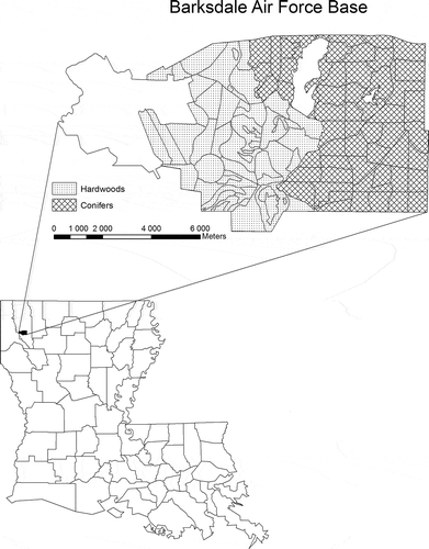
Previous studies on the forest resources of Barksdale AFB conducted by Gibson (Citation2004) involved estimating timber volume per acre only within the hardwood forest in the central portion of the base. To effectively test the utility of using Lidar to estimate forest characteristics across hardwood and conifer cover types, our study identified additional locations within the coniferous portion of the base for a hardwood, conifer and hardwood-conifer combined comparison.
Field data collection
GIS vector layers of Barksdale AFB were received from their Natural Resources Office (NRO) staff and incorporated within an ArcGIS database. The layer was modified to display only the coniferous forested eastern portion of the base. One-tenth acre sample plots (4356 sq. ft.) were selected for this study. Possible plots were created over the vector layer at 100 meter intervals and Hawth’s Tools was used to randomly determine the location of two plots within each forest unit. Plots that were not clustered were chosen for analysis. Each plot was identified by the forest unit number and assigned a unique letter. The Universal Transverse Mercator (UTM) coordinate of each plot was identified and included within the data set to aid navigation to each site.
Map layers of each plot were loaded into a Trimble Juno ST GPS unit running ArcPad 7.1 (ESRI, Redlands, CA, USA). Navigation to the center point of each plot was accomplished using the Juno ST and the center point of each plot was established on the ground with a radius of 37.24 ft. for a 1/10th acre plot. All trees within the plot radius were counted and tallied during spring 2008. A Tru-Pulse laser rangefinder was used for individual tree height and crown width measurements. Tallied tree data from the hardwood region of Barksdale AFB collected by Gibson (Citation2004) during the summer 2004 were also compiled for a hardwood, conifer and hardwood-conifer comparison. A total of 111 sample plots were identified for the analysis of tree count and tree height, with 65 and 46 plots stratified between conifer and hardwood sites, respectively. Out of 60 sample plots measured for crown width, 39 and 21 plots were stratified between conifer and hardwood sites, respectively.
Lidar data
A Lidar mission of Barksdale AFB was flown by Sky Research during the summer of 2006 to identify the munitions related features (MRFs) such as bomb craters within the forested range of the base. These post-processed Lidar data were made available for this study to ascertain its utility in aiding land managers in assessing forest tree characteristics. The Lidar data collected by Sky Research was provided by the NRO along with the vector layers of the installation. The Lidar point cloud data set received was post-processed X, Y, Z coordinate data without return information. The data was portioned by Sky Research into 423 data tiles for manageability where each tile covers a square area of 500 × 500 meters. The Lidar survey average altitude was 1000 meters above ground level (AGL) with airspeed of 105 knots and a laser repetition rate of 71 kHz. Vertical and horizontal accuracies were less than 15 and 33 centimeters RMSE, respectively. The average spot spacing was approximately 40 centimeters.
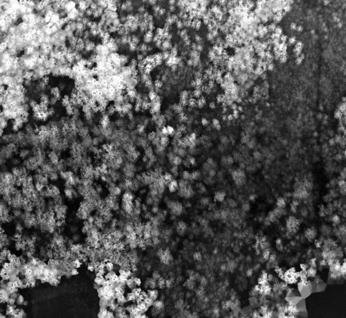
Two applications, Globalidar’s Toolbox for Lidar Data Filtering and Forest Studies version 2.2 (Globalidar, http://globalidar.com/Pages/default.aspx) and Visual Learning Systems’ Lidar Analyst 4.2 (Visual Learning Systems, Brandon, VT, USA), were compared in the extraction of trees from the Lidar point cloud. With Tiffs, the X, Y, Z text file that represented the Lidar point cloud was first imported to a raw math (MAT) file of all returns. The MAT file was then filtered to produce the DSM representing the first return of the Lidar signal (). This represents the top of the canopy, building or ground litter over the area. The filtering also produced the Digital Elevation Model (DEM) from the Lidar data. Tiffs determined the points that represented the lowest elevations across the data tile and created the DEM (). The third filtering step was the subtraction of DEM from DSM that generated an Object Height Model (OHM) (). Finally, individual trees were isolated from the OHM based on crown slope and radius and stored in vector layers. This individual trees data set was overlaid with plot boundaries in GIS and trees were tallied for count, average height and average crown width per plot.
Figure 2. Tiffs DSM of tile 115.
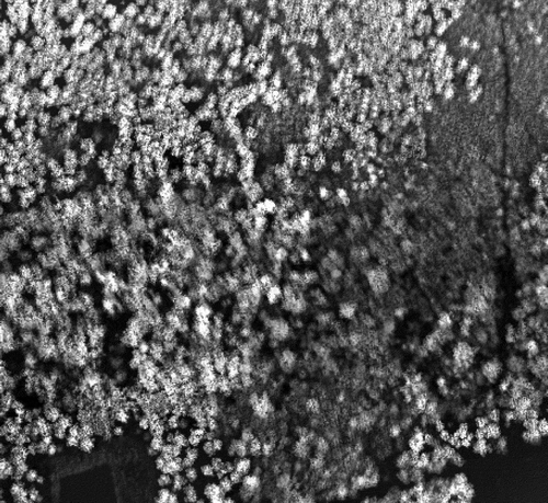
Figure 3. Tiffs DEM of tile 115.
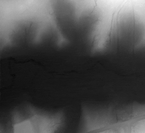
Figure 4. Tiffs OHM of tile 115.
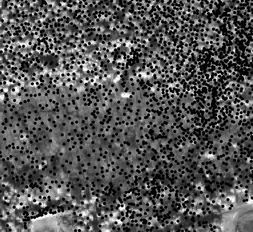
Lidar Analyst converted the X, Y, Z text file of Lidar point cloud to an American Society for Photogrammetry and Remote Sensing (ASPRS) Lidar Data Exchange Format (LAS) file and then created a raster image similar to the DSM from Tiffs (). From this raster image a bare earth layer image was extracted. This layer corresponded to the DEM layer representing the ground elevation without objects (). With a good bare earth DEM, the extraction of individual objects process began. If the area contained buildings within it, the next step was to remove them from the raster before the final step of extracting individual trees (). As there were few buildings in the study area, it was more expedient to extract the trees and then remove those trees that were actually located in buildings. Once the trees were extracted, the plot boundary vector layer was used again to select those derived trees within the plot boundaries. Finally, tree count, average tree height and average crown width per plot for Tiffs and Lidar Analyst were compared to field measurements within the forest units.
Figure 5. Lidar Analyst LAS layer of tile 115.

Figure 6. Lidar Analyst bare earth DEM of tile 115.
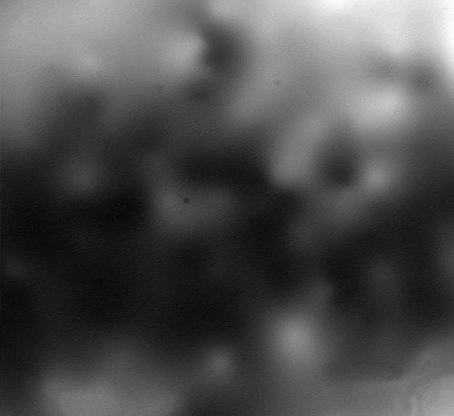
Figure 7. Lidar Analyst derived trees overlaid on top of a QuickBird image of tile 115.
Results and discussion
Tree count, average tree height and average crown width per plot from field measurements were compared to the Tiffs and Lidar Analyst derived estimates of the same locations (–). The correlation coefficient r values denoted by asterisk in – represent those that are deemed significant at the 1% level of significance identified by Avery and Burkhart (Citation1994). The 1% level of significance was used to identify a higher level of significance as nearly all correlations were significant at 5%.
Table 1. Correlation between field measured tree count per plot and Tiffs and Lidar Analyst derived estimates.
Table 2. Correlation between field measured average tree height per plot and Tiffs and Lidar Analyst derived estimates.
Table 3. Correlation between field measured average crown width per plot and Tiffs and Lidar Analyst derived estimates.
For tree count, Lidar Analyst was better than Tiffs at estimating the total number of trees within a plot as the RMSE was 3.81 trees for Lidar Analyst while Tiffs estimated fewer trees than what were found in the ground and produced an RMSE of 5.71 trees. The only significant correlation coefficient on tree count was r = 0.373 for Lidar Analyst on conifer-hardwood combined. However, this moderate positive relationship for tree count at plot level is still lower than that reported by Lee and Lucas (Citation2007) in their study in Australia with an r = 0.906. Both Tiffs and Lidar Analyst performed poorly on hardwood for tree count resulting in a negative relationship between Lidar derived and field measured trees that reconfirmed the difficulty in delineating individual hardwood trees.
Tiffs was better at deriving average tree height than Lidar Analyst with an RMSE of 19.08 feet that was lower than Lidar Analyst’s RMSE of 21.20 feet. Both software packages achieved a significantly strong relationship (r = 0.547–0.691) between Lidar derived and field measured tree height. That is the strength of any Lidar application for forestry. However, these relationships at plot level are not as strong as findings from other research such as Popescu, Wynne, and Nelson (Citation2002), reporting r = 0.922–0949 in their study of southern forests in the United States.
Lidar Analyst, with an RMSE of 25.41 feet, was better in deriving average crown diameter over Tiffs’ RMSE of 30.54 feet. However, none of the two software packages produced crown width estimates that are acceptable when compared to field measured data. The correlations were weak and not significant while the RMSEs were high. With the dense and closed canopy of our study area within the AFB, it was hard for Lidar to delineate individual tree crowns.
The Lidar data were limited to an X, Y, Z format without return information embedded with the file. The ease of use and functionality of extracting biophysical characteristics may be improved with complete Lidar data sets. Tiffs and Lidar Analyst were able to handle this data set and produce reasonable DEMs and extract individual tree characteristics. Lidar Analyst had additional control of the parameters used for the extraction; however, both programs worked well for the purposes of this study. Tiffs did have difficulties removing buildings from the data set and resulted in placing trees where buildings exist. On the other hand, Lidar Analyst created buildings which did not exist. Therefore, the buildings layer had to be modified to remove non-buildings and reshape extracted buildings before creating the trees layer.
Conclusions
This project evaluated two Lidar data processing software packages from a forester’s perspective using traditional field plot sampling. Both software packages performed well in estimating tree height. Although the RMSEs are not low, with the acceptable correlation between Lidar derived and field measured data, accurate tree height estimation can be achieved with some calibration. As to delineating individual tree and tree crown, the results from both packages were problematic.
As for specific forestry applications, Tiffs was easier to use. In this study Tiffs created CHM, DEM and OHM models quickly. On the other hand, Lidar Analyst appeared to extract trees that better represented actual trees measured on the ground. However, Lidar Analyst took longer to set up for creation of the DEM in some areas of the study site. Both software packages handled the X, Y, Z data files well and did not appear to have problems with data not having return information.
References
- Avery, T., and H. Burkhart. 1994. Forest Measurements, 408. 4th ed. New York: McGraw-Hill.
- Campbell, J. 2002. Introduction to Remote Sensing, 621. 3rd ed. New York: The Guilford Press.
- Chen, Y., and X. Zhua. 2013. “An Integrated GIS Tool for Automatic Forest Inventory Estimates of Pinus Radiata from Lidar Data.” Giscience & Remote Sensing 50 (6): 667–689.
- Danson, F. M., and P. J. Curran. 1993. “Factors Affecting the Remotely Sensed Response of Coniferous Forest Plantations.” Remote Sensing of Environment 43: 55–65. doi:10.1016/0034-4257(93)90064-5.
- De Wulf, R., R. Goossens, B. De Roover, and F. Borry. 1990. “Extraction of Forest Stand Parameters from Panchromatic and Multispectral SPOT-1 Data.” International Journal of Remote Sensing 11: 1571–1588. doi:10.1080/01431169008955115.
- Dubuyah, R. O., and J. B. Drake. 2000. “Lidar Remote Sensing for Forestry.” Journal of Forestry 98 (6): 44–46.
- Franklin, J. 1986. “Thematic Mapper Analysis of Coniferous Forest Structure and Composition.” International Journal of Remote Sensing 7: 1287–1301. doi:10.1080/01431168608948931.
- Gambill, C., H. Wiant, and D. Yandle. 1985. “Optimum Plot Size and BAF.” Forest Science 31: 587–594.
- Gibson, M. 2004. “Using Ikonos Multispectral Satellite Imagery to Map Bottomland Hardwood Forests in Northwest Louisiana.” Master Thesis, Stephen F. Austin State University, 198.
- Gleason, C. J., and J. Im. 2011. “A Review of Remote Sensing of Forest Biomass and Biofuel: Options for Small-Area Applications.” Giscience & Remote Sensing 48 (2): 141–170. doi:10.2747/1548-1603.48.2.141.
- Hawbaker, T. J., T. Gobakken, A. Lesak, E. Trømborg, K. Contrucci, and V. Radeloff. 2010. “Light Detection and Ranging–Based Measures of Mixed Hardwood Forest Structure.” Forest Science 56 (3): 313–326.
- Hyyppä, J., H. Hyyppä, D. Leckie, F. Gougeon, X. Yu, and M. Maltamo. 2008. “Review of Methods of Small‐Footprint Airborne Laser Scanning for Extracting Forest Inventory Data in Boreal Forests.” International Journal of Remote Sensing 29 (5): 1339–1366. doi:10.1080/01431160701736489.
- Ioki, K., J. Imanishi, T. Sasaki, Y. Morimoto, and K. Kitada. 2010. “Estimating Stand Volume in Broad-Leaved Forest Using Discrete-Return Lidar: Plot-Based Approach.” Landscape and Ecological Engineering 6 (1): 29–36. doi:10.1007/s11355-009-0077-4.
- Lee, A. C., and R. M. Lucas. 2007. “A Lidar-Derived Canopy Density Model for Tree Stem and Crown Mapping in Australian Forests.” Remote Sensing of Environment 111 (4): 493–518. doi:10.1016/j.rse.2007.04.018.
- Lefsky, M. A., W. B. Cohen, G. G. Parker, and D. J. Harding. 2002. “Lidar Remote Sensing for Ecosystem Studies.” Bioscience 52 (1): 19–30. doi:10.1641/0006-3568(2002)052[0019:LRSFES]2.0.CO;2.
- Lim, K., P. Treitz, M. Wulder, B. St-Ongé, and M. Flood. 2003. “Lidar Remote Sensing of Forest Structure.” Progress in Physical Geography 27 (1): 88–106. doi:10.1191/0309133303pp360ra.
- Means, J. 1999. “Design, Capabilities and Uses of Large-Footprint and Small-Footprint Lidar Systems.” International Archives of the Photogrammetry and Remote Sensing 32: 201–207.
- Popescu, S. C., R. H. Wynne, and R. F. Nelson. 2002. “Estimating Plot-Level Tree Heights with Lidar: Local Filtering with a Canopy-Height Based Variable Window Size.” Computers and Electronics in Agriculture 37 (1–3): 71–95. doi:10.1016/S0168-1699(02)00121-7.
- Spanner, M., L. Pierce, D. Peterson, and S. Running. 1990. “Remote Sensing of Temperate Coniferous Forest Leaf Area Index the Influence of Canopy Closure, Understory Vegetation and Background Reflectance.” International Journal of Remote Sensing 11: 95–111. doi:10.1080/01431169008955002.
- Trotter, C., J. Dymond, and C. Goulding. 1997. “Estimation of Timber Volume in a Coniferous Plantation Forest Using Landsat TM.” International Journal of Remote Sensing 18: 2209–2223. doi:10.1080/014311697217846.
- van Leeuwen, M., and M. Nieuwenhuis. 2010. “Retrieval of Forest Structural Parameters Using Lidar Remote Sensing.” European Journal of Forest Research 129 (4): 749–770. doi:10.1007/s10342-010-0381-4.