
Abstract
This paper presents an objective approach for quantifying the amount of mangrove loss caused by expansion of shrimp farms in three villages of Krabi Province, Thailand. Landsat images from three time periods of shrimp farm development (pre-shrimp farms – 1989, development – 2001, and post-development – 2007) were analyzed using unsupervised classification algorithm. A post-classification change detection comparison approach revealed only moderate mangrove exploitation and shrimp farms, which displaced a variety of land-cover types in addition to mangroves. In some cases, there was a detectable cycle of use and replenishment of mangroves and a lack of the boom-bust cycle of shrimp farming that other parts of Thailand experienced.
1. Introduction
Mangrove forests are considered to be one of the world’s most productive and biologically complex ecosystems as well as socio-economically important for the inhabitants of coastal communities that depend on them as a source of income, fuel, medicine and coastal protection (Barbier and Strand Citation1998; Kathiresan and Qasim Citation2002; FAO Citation2007; Rönnbäck, Crona, and Ingwall Citation2007; Hussain and Badola Citation2010; Vo et al. Citation2012). However, throughout the world mangrove forests are threatened with destruction through multiple forms of anthropogenic pressure, including aquaculture development (Upadhyay, Ranjan, and Singh Citation2002; Hernández-Cornejo et al. Citation2005; Vo et al. Citation2013). This research documents the complex land conversion patterns in three coastal villages of Thailand from 1989 to 2007. A time-series of three Landsat images from 1989, 2001, and 2007 was used to document the extent and nature of mangrove conversion and shrimp farm development. The research establishes the change in land use from mangrove forests to rice paddies, shrimp farms, palm oil plantations, rubber plantations, and silviculture, and identifies areas that are re-established to mangrove forest. This study presents a methodology that will aid coastal communities in Southeast Asia in determining sustainable land-use conversion approaches by understanding the complexity and dynamics of land change.
Mangrove forests, living in saline environments in the intertidal zone, are distributed throughout tropical and subtropical latitudes across the globe. Between 70 and 90 species of mangroves are known to exist in the world (Christensen Citation1983; FAO Citation2007). Mangroves provide a variety of goods and services to humans, including on-site fisheries, fuel wood collection, timber harvests, off-site fishery support, aquaculture (e.g., shrimp farming), carbon sequestration, growing of medicinal plants, biodiversity, and recreation (Kuenzer et al. Citation2011). Mangrove ecosystems also provide an array of important indirect services such as prevention of storm damage, flood control, waste absorption, recreation, and transport (Kaplowitz Citation2000). The major land uses that result in the destruction of mangrove forests in Asia and Thailand in particular are aquaculture, timber harvesting, and urban development. Unrestricted clear felling, aquaculture, and overexploitation of fisheries are the greatest threats to mangroves, with accompanying effects on hydrology, as well as water and air pollution (Alongi Citation2002).
However, restoration of mangrove ecosystems can be achieved; in fact, mangroves have been cultivated for several centuries. Mangroves can grow and thrive if hydrological and geomorphological conditions are suitable, and there is some evidence that replanted forests can approach the biomass, stand structure, and productivity of undisturbed forests within 20–25 years (Mckee and Faulkner Citation2000). In Thailand, one of the main causes of mangrove conversion is shrimp farming, which is a major source of export income for the country (Aksornkoae and Tokrisna Citation2004). In Thailand, mangrove forest area has been reduced from about 5500 km2 to 2470 km2 during the 1961–1986 time period (Spalding, Kainuma, and Collins Citation2010).
Shrimp farming is one of the fastest growing aquaculture sectors in many parts of the world as well as one of the most controversial. In 2004, aquaculture production reached 59 million tons, with a farm gate value of US$70 billion (FAO/NACA/UNEP/WB/WWF Citation2006). Intensive shrimp farming arrived in Thailand during the 1980s and developed virtually unregulated until 1987 (Huitric, Folke, and Kautsky Citation2002). Shrimp farming in the Inner Gulf of Thailand increased dramatically in the mid-1980s, expanding to the Western Gulf, then to the Eastern Gulf, and finally to the Andaman Sea. This expansion has come largely at the expense of indigenous mangrove forests as extensive mangrove areas have been converted into aquaculture ponds. Deforestation of mangrove forests for aquaculture, particularly shrimp farming, in coastal Thailand presents serious environmental and societal problems. Many researchers argue that aquaculture development has provided few economic benefits to local people while contributing greatly to environmental degradation (Cooley Citation1999; Stonich Citation1995; Barraclough and Finger-Stich Citation1996; Sathirathai and Barbier Citation2001).
One of the goals of this study is to document the amount of mangrove forests that have been converted to shrimp farming and other land uses. Numerous scientists have worked on developing algorithms for change detection, such as image regression (Singh Citation1989), write function memory insertion (Jensen et al. Citation1993), spectral change vector analysis (CVA) (Lambin and Strahler Citation1994), and others. The use of geographic information system (GIS) technology allows further analysis of primary data extracted from the remotely sensed images and interpretation of the impact of land use and land-cover change on regional sustainable development (Xiuwan Citation2002).
While Blasco et al. (Citation1998) conclude that aerial photography is best suited for investigating density, phenology, and hydrological status of mangrove forest due to its fine spatial resolution, its availability and preprocessing requirements often limit its use. Satellite remote-sensing data (e.g., 30 m resolution Landsat) are believed to be the most effective data source available for measuring the extent, structure, and characteristics of large mangrove areas on a repetitive basis (Ramsey and Jensen Citation1996).
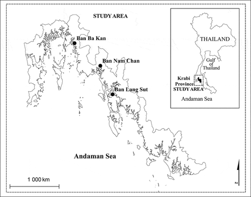
2. Study area
The study area consists of three research sites – the coastal villages of Ban Nam Chan, Ban Lang Sut, and Ban Ba Kan, all situated within Krabi province, Thailand (). Geographically, the province is located between 7°30ʹ and 8°40ʹ North latitude, and 98°44ʹ and 99°18ʹ East longitude. Krabi Province extends about 160 km along the coast of the Andaman Sea. Krabi Province is covered by two Landsat World Reference System (WRS) path/row combinations (Path 129/Row 54 and Path 129/Row 55).
Figure 1. Location of study area.
Due to the influence of the tropical monsoon, Krabi experiences only two seasons: the hot season (January–April) and the rainy season (May–December) with temperatures ranging from 22.4º to 34.0ºC and rainfall variation from 39.0 to 1071.0 mm/month with an average of 1900 mm per year (WWF Citation2008). Much of the provincial coastline is covered with mangrove forests.
The village of Ban Nam Chan has around 1200 inhabitants and is the second largest of the three villages under study. The locals in this village historically grew rice, but the paddies are now mostly converted to shrimp farms. The second of the villages under study, Ban Lang Sut, is inhabited by 651 people and is the smallest of the three study villages and the furthest from Krabi Town, the provincial capital. Historically, the village engaged in charcoal production but has experienced land-cover change over the years from mangrove and agricultural land to shrimp farms and, more recently, conversion to palm oil plantations. The village of Ban Ba Kan is the largest of the three villages with around 1990 villagers. Historically the villagers grew rice, but many of the rice fields have been converted to shrimp farms. Another recent phenomenon in the village area is the appearance of palm oil plantations next to already established rubber plantations.
3. Background
The field of remote sensing offers many advantages for extensive, accurate, and cost-effective mapping of mangrove forests as well as tracking changes over time. A wide variety of image processing methods satisfy the growing demand for theoretical- and application-based studies for mangrove analysis.
3.1. Change detection
After comparing some of the most widely used change detection techniques and performing accuracy assessment, Mas (Citation1999) concluded that the highest accuracy was obtained using the straight-forward post-classification comparison method. While the image differencing procedure utilizes a simple subtraction of the first-date image from the second date on a pixel-per-pixel basis, it is dependent on precise radiometric correction and cannot provide a detailed change matrix. The principal component analysis is a method that works under the assumption that multitemporal data are highly correlated and the change information can be transformed into principal components, thus reducing data redundancy between the bands, while emphasizing the difference information in the resulting components (Singh Citation1989; Lu et al. Citation2004). However, this multivariate analysis technique cannot provide a detailed ‘from-to’ change matrix and, in many cases, researchers have stated that one of its main disadvantages is the difficulty in interpreting the results of the transformed new images (e.g., Sunar Citation1998; Mas Citation1999; Lu et al. Citation2004; Jensen Citation2005). CVA is a multivariate change detection technique that processes any number of spectral bands and produces two outputs: change magnitude and change direction. Although it can be difficult to identify land-cover change trajectories, the method has strong merits with its ability to process any number of spectral bands and to produce detailed change detection information (Coppin et al. Citation2004; Lu et al. Citation2004).
The post-classification comparison method called by Singh (Citation1989) ‘the most obvious method of change detection’ requires independently produced classified images to be compared with each other. This method avoids issues associated with achieving accurate registration of multi-date images; however, one needs to take into consideration that the accuracy of the change detection is a result of the multiplication of the multi-date classification accuracies (Pons, Serra, and Sauri Citation2003; Stow, Tinney, and Estes Citation1980; Robinson Citation1979). For example, two images each with accuracy of 80% (0.80 * 0.80 * 100 = 64%) will have change detection accuracy of only 64%. In one study estimating mangrove transformation and shrimp farm establishment, the authors used a post-classification comparison procedure for a supervised classification (Alonso-Pérez et al. Citation2003). Their accuracy assessment (overall accuracy of 85%) was performed using over 100 ground truth points. By correctly coding the classification and change detection results using the post-classification comparison method, a detailed ‘from-to’ matrix of change can be obtained, which is considered one of its most valuable merits (Jensen Citation2005). This method can also reduce problems with atmospheric differences between images since the two dates are separately classified. However, one of its main disadvantages is that the accuracy of the change detection is dependent on the accuracy of the initial classifications. The estimated final accuracy exhibits similarities with the result of multiplying the accuracy of each individual classification and can sometimes be quite low (Singh Citation1989; Lambin and Strahler Citation1994).
After reviewing the possible approaches to change detection, the post-classification comparison method was selected for this study. This method's main disadvantage was taken into consideration and additional procedures (usually not performed with this method) were executed in order to secure a higher level of accuracy of the final product – detailed geometric rectification and radiometric correction of all three satellite images.
3.2. Tracking change in mangroves and shrimp farms
Remote sensing is widely thought to be the optimal technique available for measuring the extent, structure, and characteristics of large mangrove areas on a repetitive basis (Ramsey and Jensen Citation1996). Although Blasco et al. (Citation1998) conclude that aerial photography is best suited for mangrove research, the consistency of the spatial and spectral characteristics of Landsat, as well as its availability throughout the period of study, enables reliable results. Active shrimp farms contain water most of the time and are easily identifiable by their distinctive low reflectance (dark color) and spatial pattern.
There is also the capability to track the progression of land-use change throughout the period of study. This provides the ability to determine the longevity and persistence of shrimp farms and allows monitoring of the subsequent history of deforested mangrove areas. For example, those pixels that were converted from mangrove to shrimp farms can be tracked to determine approximately how long they stay as shrimp farms (the literature states that it is typically a 5–10-year cycle; Dierberg and Kiattisimkul Citation1996) and to what land-use class it is converted.
The use of GIS techniques allows further analysis of the data extracted from the remote-sensed images and interpretation of the impact of land-use and land-cover change on regional sustainable development (Xiuwan Citation2002). With the use of remote sensing and GIS technology in the process of assessment and monitoring, forest management guidelines, and progress toward conservation and sustainability goals can be documented (Dahdouh-Guebas Citation2002).
Another substantial factor influencing the results and conclusions of research is the time-frame (initial and final year) of the phenomenon under study. Giri et al. (Citation2007) used more than 750 Landsat satellite images across the tsunami-impacted regions of Indonesia, Malaysia, Thailand, Myanmar, Bangladesh, India, and Sri Lanka to evaluate the state of the mangrove forests. The main finding of their research reveals that 81% of the mangrove deforestation from 1975 to 2005 is a result of agricultural encroachment and not due to shrimp farm development, contrary to what is found in many studies (e.g., Kongsanchai Citation1994; Aksornkoae and Tokrisna Citation2004; Christensen Citation1983; Sathirathai and Barbier Citation2001; Dahdouh-Guebas et al. Citation2002). However, any intermediate land-cover change (such as conversion to shrimp farms, then to agriculture) that took place between the start and end dates of study would not necessarily be identified.
4. Data
To understand the dynamics of land-use change within the mangrove areas of the research site, three Landsat satellite images collected from 1989 (Landsat 4 TM), 2001 (Landsat 7 ETM+), and 2007 (Landsat 5 TM) are used to estimate land-cover change. Landsat was selected as the remote-sensing source due to its long-term continuity, as well as its temporal, spatial, and spectral characteristics. The image data were collected from dates to coincide with the different stages of mangrove forest and shrimp farm development, that is, before development (1989), during the peak of shrimp farm activity (2001), and as close to the time of the ground data collection as possible (2007). Near-anniversary dates were selected during the dry season in Thailand. The data processing approach was designed to be as consistent as possible to facilitate the land-cover change analysis.
4.1. Data acquisition
Background research determined the beginning of the time frame for this project – the initial date the satellites acquired data needed to be before 1990 so the mangroves would not have been cleared for aquaculture development, thus estimating total mangrove conversion for a period of ca. 20 years – the final date being as recent as possible to the time of associated field work conducted in 2008. The intervals between the initial and the final year had to be carefully selected and many factors were taken into consideration. The decision was made to seek to acquire data for anniversary dates of 1990, 2000, and 2007. However, this brought about another challenge – very often images over the tropics are covered with clouds that makes the images unsuitable for such a study. In order to acquire anniversary dates for the three time periods during the dry season (December through May), the year to be selected had to be cloud free and available. The final selection was 1989 (5 February), 2001 (22 February), and 2007 (3 March). The three satellite images were acquired from three different sources – United States Geological Survey (USGS) for the 1989 data, University of Maryland Global Land Cover Facility (GLCF) for the 2001 data, and Geo-Informatics and Space Technology Development Agency of Thailand (GSDA) for the 2007 data.
4.2. GIS reference data
The GIS data-sets used in this study consisted of two demographic data-sets and the boundaries of the province of Krabi, the districts, and sub-districts. The data were provided by the Department of Environmental Quality Promotion of Thailand. These files were used at the initial stages of the research to help implement the criteria for the random selection of the villages as well as to establish the boundaries of each of the three villages.
5. Methodology
Because the study area spans two Landsat images, two adjacent images (path 129, rows 54 and 55) were acquired and mosaicked together in order to obtain the entire area under investigation. The second step of the preprocessing involved establishing boundaries of the three villages with the surrounding mangrove forests (regions of interest) for subsetting the mosaicked images. Geometric and radiometric corrections of the satellite data were performed on the subset images to improve the quality and make the satellite data consistent between the three study dates. As a final step of the preprocessing, a land/water mask was created in order for the classification and change detection to be performed only over the terrestrial part of the research site. The classification method was selected after reviewing the commonly used land-use/land-cover classification systems. As a result of this review and considering requirements of the study, an unsupervised classification method was selected using six land-use/land-cover classes (mangrove forest, disturbed mangrove, non-mangrove vegetation, shrimp farms, developed areas, and bare ground). An evaluation of the classification was performed and finally, an analysis of land change dynamics over each village.
5.1. Selection of villages
Since the original satellite data (path 129/rows 54 and 55) cover a large area exceeding the study area, the image size was reduced to define the exact study area. The coastline of Krabi province was digitized to create a boundary that was used to create a buffer zone (5 km) inland to help determine villages that are ‘coastal villages’ and to restrict the image to the coastal zone only. Only villages situated within 1 km of the water (the coastline or the canals) were considered to have the best potential to be directly involved with mangrove to shrimp farm conversion. A spatial stratification was employed to reduce any spatial dependencies of land conversions and to improve the possibility of including villages that may have differing land change dynamics. The image was spatially stratified by using the latitudes of the northernmost as well as the southernmost part of coastal Krabi and dividing the north to south extent into three roughly equal segments. Within each of the three segments, a random sampling procedure was applied to select a village for analysis. During field work conducted in 2008 and with the help of the village chiefs and their assistants, the extent of the village (which included the canals and mangroves that are utilized by the village) was adjusted by drawing the boundary on hard-copy prints of the satellite image.
5.2. Geometric correction
Geometric correction was performed using the image-to-image registration method. The data from the GLCF contained quality image-based information from the original satellite data and supporting geometric information from a geodetically accurate map (Tucker et al. Citation2004). Because of the existing geometric information, the 2001 GLCF image was used as an ‘anchor’ to which the other two images (USGS 1989 image and GISTDA 2007 image) were geometrically registered. Although a reference image should be as similar to the other images as possible, in this study the anchor image is the only terrain-corrected (orthorectified) image of the three. This does not present a serious issue since the study area is situated entirely within the coastal area with an elevation change of less than 5 m ASL.
5.3. Radiometric correction
A multi-step approach was utilized to perform the radiometric correction including a dark object minimum value subtraction (DO_MVS) (Kennedy et al. Citation2007) and image normalization using a histogram matching approach that performed band-by-band shifts of the digital number values until the histogram distributions matched. This step resulted in a set of images that have similar reflectance ranges within each band that lend themselves better to change analysis.
5.4. Land/water mask
As the final preprocessing step, a land/water mask was created to eliminate the water (canals and sea) from the classification, thus permitting the classification and change analysis to be conducted only over the terrestrial portion of the study area. For this task, the images from 1989 over the three villages were used for water masking. This decision was made because in 1989 there is an absence of shrimp farms that reduces the likelihood of masking shrimp farm-related water bodies (one of the objectives of the study) from being eliminated from the analysis.
The land/water mask was created using a threshold approach on band four (near-infrared or NIR band), followed by visual refinement (with onscreen digitization) to ensure better accuracy and precision while taking into consideration that the final mask was to be applied to the other two images (2001 and 2007).
5.5. Image classification
Since the goal of the study was to estimate the change in mangrove forest area as well as shrimp farm development over the time frame 1989–2007 in three coastal villages, the classification was performed only over the area of these three villages as defined from the GIS files and approved by the village chiefs and assistant chiefs. The importance of keeping the study area precisely the same in the different time periods ensures a consistent estimate of the change statistics (Jensen Citation2005).
After a review of commonly used land-use/land-cover classification systems (Anderson et al. Citation1976; Cowardin et al. Citation1979; Loveland and Belward Citation1997), it was determined that an independent adaptation of these classification schemes was needed to meet the goals of the study (). Each of the established classification schemes has its strengths and weaknesses. For instance, the IGBP scheme (Loveland and Belward Citation1997) is well suited to global classification and has a very general scheme, while Cowardin et al.’s (Citation1979) scheme includes detailed wetland classes, but is weaker on other land-use types. The classification developed for this study contains the following land-use/land-cover classes: water, mangrove forest, disturbed mangrove (less density due to selective cutting), non-mangrove vegetation (e.g., plantation and agriculture), shrimp farms, developed areas (e.g., villages, which contain houses and developed land around them), and bare ground (clear cut or non-vegetated areas). Each of the target classes were expected to have separable spectral characteristics that would produce a high-quality classification.
Table 1. Land-use/land-cover classification scheme used for this study.
An unsupervised classification algorithm (ISODATA) was used. The classification was performed for one village at a time using the three dates of masked imagery (1989, 2001, and 2007). At the initial stage of classifying the images, 20 classes were created, which later were grouped into the final 7 classes. The labeling and post-classification refinement were performed using knowledge gained during field work, taking into account the spatial context of the classes, and using high-resolution ancillary data, such as GoogleEarth. This procedure was repeated for all three years for all three villages. Since the images from 1989 do not have shrimp farms, Class 5 – shrimp farms – had 0 pixels in it. The spectral characteristics of some of the classes turned out to be relatively similar, which made it necessary to interactively (using onscreen digitizing) split or merge them. These similar classes are Class 6 (developed areas) and Class 7 (bare ground), as well as Class 3 (disturbed mangrove forest) and Class 7 (bare ground).
5.6. Change detection
The change detection approach used for this research was post-classification comparison. This approach utilizes the separately classified images for each time period and performed a per-pixel comparison between time periods in matrix form. Because the classifications, rather than the original band-by-band digital numbers, are used for comparison, atmospheric, sensor, and environmental differences between the images are minimized and a matrix of change information is created. The change detection matrix summarizes all of the combinations of ‘from-to’ changes in land use/land cover between the years.
5.7. Accuracy assessment
Conducting an accuracy assessment is a challenging, yet essential part of the classification process that can require as many or more resources than the rest of the study combined. Such an assessment is especially difficult in mangrove forests due to extreme difficulty in accessing the often nearly impenetrable forest. Even though GPS points over the study area were collected, the fact that the points were not collected as a random or stratified random sample and the lack of differential correction made them unfavorable to use for accuracy assessment. In any case, such accuracy could have been performed only for the year 2007 since GPS points were collected in 2008, acquiring GPS point collected in previous years was not possible. The traditional approach for performing an accuracy assessment involves the acquisition of a higher spatial resolution data (e.g., either satellite data with higher spatial resolution or aerial photographs of the specific area (Congalton and Green Citation1999; Jensen Citation2005) or ground observations). Such data over the study area were not readily available. As stated by Cohen and colleagues (Citation1998) when independent reference data are unavailable, a visual assessment comparing the Landsat data to the classification is a credible means of assessing map error. Moreover, even when such independent data are available, the cost of obtaining and processing them may make them an undesirable option relative to visual assessment techniques.
The original Landsat images of the study area, displayed as false color composites, were used as reference data for visual interpretation. A total of 100 individual pixels were randomly sampled from each of the nine classified images (three time periods for each of three villages) and used for evaluation. The reference images were visually interpreted for land-cover class without reference to the classified images and subsequently compared to the classification results.
An error matrix was produced and an overall accuracy as well as Kappa coefficient of agreement was estimated for all three villages ().
Table 2. Accuracy assessment of the classification for the three villages (1989, 2001, 2007).
The widely used assessment of agreement between reference observations and classification observations is the Khat coefficient of agreement (Congalton and Mead Citation1983; Feinstein Citation1998; Foody Citation2002). This is also called Kappa analysis. It is calculated using the following formula (Equation (1), from Jensen Citation2005)
where xi is the number of observations correctly classified for each category, xi+ and x + j are the totals for row i and column j associated with that category, and N is the total number of observations.
The Kappa coefficient of agreement statistic gives an overall value to the classification accuracy. According to Lands and Koch (Citation1977), K-values >0.80 represent strong agreement, K-values between 0.40 and 0.80 represent moderate agreement, and K-values <0.40 represent poor agreement.
The villages of Ban Nam Chan and Ban Lang Sut have K-values higher than 0.83 for all three years (). The village of Ban Ba Kan has K-values of 0.78, 0.76, and 0.84 for the years 1989, 2001, and 2007, respectively.
An accuracy of the change detection maps was conducted by multiplying the overall accuracies of the two classifications (Singh Citation1989; Pons, Serra, and Sauri (Citation2003). The accuracy assessment of each time frame (e.g., 1989–2001, etc.) was calculated by this method, thus change detection accuracy for the period of 1989 to 2007 for the village of Ban Nam Chan is 80% (e.g., 0.9 * 0.89 = 0.80). The accuracy of the change detection ranged from 71% to 82% over all villages ().
Table 3. Accuracy assessment of the change detection for the three villages (1989, 2001, 2007).
6. Land-cover change results
The results of the land-cover change analysis are presented by village and by time period. The results are summarized for changes that took place from 1989 to 2001, from 2001 to 2007, and from the 1989 to 2007 period. As the results are presented, it is important to note that there was a slight change in the water class for all of the villages and time periods, despite the fact that a water mask was used. The change was primarily to or from mangrove forest, which can be accounted for by the slight misregistration of the images or by expansion or contraction of mangrove crown cover. The change results are counted in number of pixels, which are just under a tenth of a hectare each.
6.1. Ban Nam Chan land-cover change
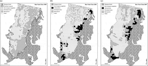
The classification maps for each time period for Ban Nam Chan are shown in –). A visual assessment shows good consistency between the years, except some inconsistencies with the developed and bare ground classes. This is not surprising as both of these classes have high reflectance and high intraclass reflectance variability. It is clear that the shrimp farm development took place along the mangrove margins.
Figure 2. Land-cover classification map of Ban Nam Chan: (a) 1989, (b) 2001, (c) 2007.
6.1.1. Land-cover change from 1989 to 2001
The results of the change from the 1989 to the 2001 time period over Ban Nam Chan are shown in . To interpret the table, the numbers in each cell represent the number of pixels that belonged to the land-use/land-cover class during the earliest time period (in 1989) in the far-left column and that was later classified as the class shown in the topmost column on the second date (2001). Mangrove forests remained largely intact with 95 pixels converted to non-mangrove vegetation and 109 pixels converted to shrimp farms. The change to shrimp farms, in particular, is a well-defined change in reflective characteristics (from healthy vegetation to water) and is a high-confidence change. It is noteworthy that most of the shrimp farms in 2001 came from non-mangrove vegetation, which is primarily composed of agricultural areas or plantations. A significant portion of shrimp farms also came from developed areas and bare ground at the margins of the village. The mangroves that were converted to shrimp farms are primarily at the southern end of the image at the edge of the mangrove forest. One of the other primary changes is the development of bare ground to non-mangrove vegetation.
Table 4. Land-cover change from 1989 to 2001, 2001 to 2007, and 1989 to 2007 in Ban Nam Chan.
6.1.2. Land-cover change from 2001 to 2007
Contrary to the overall trend in Thailand, Ban Nam Chan actually experienced a modest increase in shrimp farm area (486 to 532 pixels) from 2001 to 2007 (). However, it is also the case that some of the 2001 shrimp farms (162 pixels) were converted to bare ground in 2007. This conversion was more than offset by the conversion of mangrove and non-mangrove vegetation to shrimp farm. The mangrove forest remained relatively stable both in total area and in the same areas remaining mangrove forest over this time period.
6.1.3. Land-cover change from 1989 to 2007
When viewing the overall change from 1989 to 2007 (), the primary change is from mangrove to shrimp farming (169 pixels) even though the mangroves during this period increased with 3.17%. In fact, while looking at this longer time period of change, it is clear that shrimp farms were largely developed at the expense of mangrove forests. Other land-use/land-cover types that were converted to shrimp farms include non-mangrove vegetation and developed areas, primarily at the margins of the village.
6.2. Ban Lang Sut land-cover change
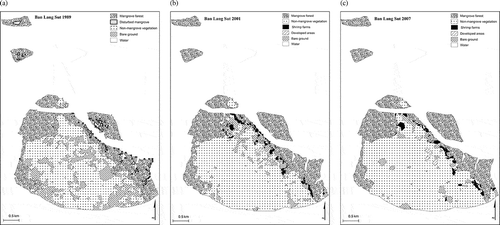
The classification results for Bang Lang Sut are shown in (a–c). A cursory visual interpretation of the three time periods shows general consistency among the shrimp farm development along the margins of the mangrove forest and non-mangrove vegetation and a small amount of development.
Figure 3. Land-cover classification map of Ban Lang Sut: (a) 1989, (b) 2001, (c) 2007.
6.2.1. Land-cover change from 1989 to 2001
shows that the village experienced a decrease in total mangrove area from 1989 to 2001 (4806 to 4597 pixels), largely through conversion to non-mangrove vegetation (190 pixels) and to shrimp farm development (166 pixels). The 2001 shrimp farms came largely from mangrove forests, with non-mangrove vegetation as the second largest contributor. Non-mangrove vegetation increased substantially from 6339 to 7625 pixels, with the increase coming primarily from bare ground. No areas were identified as developed in 1989, as the village was very small consisting of small homes and narrow roads. A small amount of development between 1989 and 2001 was detectable from the land-use/land-cover classification.
Table 5. Land-cover change from 1989 to 2001, 2001 to 2007, and 1989 to 2007 in Ban Lang Sut.
6.2.2. Land-cover change from 2001 to 2007
As illustrates, the period from 2001 to 2007 saw little change in the shrimp farm area (338 to 326 pixels), while mangrove forests also experienced a slight decrease (4597 to 4450 pixels). The mangroves were converted both to non-mangrove vegetation (271 pixels) and to shrimp farms (99 pixels). The 2001 era shrimp farms were converted to non-mangrove vegetation and to bare ground, while new shrimp farms came primarily from mangrove forests.
6.2.3. Land-cover change from 1989 to 2007
When examining the land-use/land-cover change over the entire period of study (), the amount of mangrove loss (4806 to 4450 pixels) is not dramatic. The primary change was in non-mangrove vegetation (6339 to 8346 pixels), which came primarily from the conversion of bare ground. Shrimp farm development was primarily from mangrove forests (198 out of 326 pixels), with non-mangrove vegetation as the second largest contributor.
6.3. Ban Ba Kan land-cover change
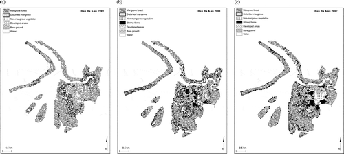
The classification results for Ban Ba Kan for the three time periods are shown in (a–c). Visual inspection reveals a consistent increase in shrimp farm development, but also a relatively stable mangrove forest. Most of the shrimp farm development appears to have taken place in close proximity to the village.
Figure 4. Land-cover classification map of Ban Ba Kan: (a) 1989, (b) 2001, (c) 2007.
6.3.1. Land-cover change from 1989 to 2001
shows that Ban Ba Kan experienced a nearly 9% loss of mangroves from the period of 1989 to 2001 (6111 to 5576 pixels). The conversion was primarily to disturbed mangrove. Shrimp farm development came primarily from bare ground and developed areas and more modestly from mangrove and non-mangrove vegetation.
Table 6. Land-cover change from 1989 to 2001, 2001 to 2007, and 1989 to 2007 in Ban Ba Kan.
Table 7. Change in mangrove cover for three villages: Ban Nam Chan (BNC), Ban Lang Sut (BLS), Ban Ba Kan (BBK).
6.3.2. Land-cover change from 2001 to 2007
From 2001 to 2007, the shrimp farm area nearly doubled in size (242 to 447 pixels), largely due to conversion of bare ground and developed areas along the village margins (). There was also an increase in total mangrove area (5576 to 5980 pixels), primarily coming from the disturbed mangrove class.
6.3.3. Land-cover change from 1989 to 2007
When examining the total change in land cover from 1989 to 2007 (), the mangrove loss was not dramatic (6111 to 5980 pixels), with movement between disturbed mangroves and mangroves in both directions (from-to and to-from). Shrimp farms were developed from nearly every other cover type in equal proportions, but primarily from bare ground.
6.4. Overall change in mangroves and shrimp farms
All three of the villages experienced mangrove loss during the 1989 to 2001 time period (). Ban Nam Chan had the least percentage loss (1.5%) decrease, Ban Lang Sut fits in the middle with (4.34%) decrease, while Ban Ba Kan experienced a large (8.75%) decrease. This decrease was nearly compensated for by the 7.24% increase in mangrove area experienced between 2001 and 2007 in the village of Ban Ba Kan. Ban Nam Chan also experienced an increase in mangrove area (4.74%), while Ban Lang Sut experienced another decline (3.17%) during this time period.
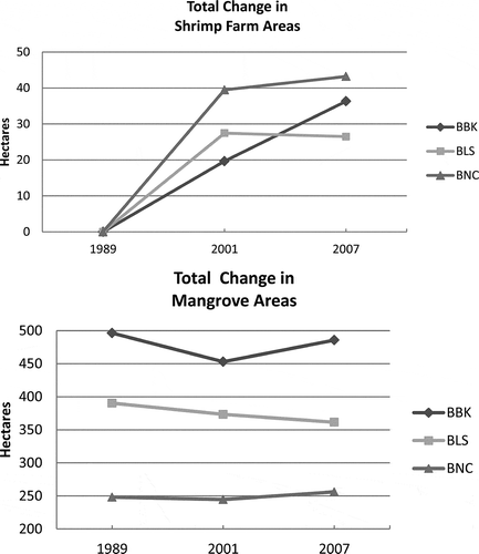
(a, b) shows the change in both shrimp farm and mangrove extent over the three villages and illustrates the patterns of change (or lack thereof) in Krabi province. The patterns of both mangrove and shrimp farm change are distinct for each village, with BBK showing a drop, then rise of mangrove area (with a net decrease over the period of study), while experiencing continued growth in shrimp farm area. BLS shows a steady decline in mangroves and a rise, then leveling off of shrimp farms. BNC shows a relatively steady mangrove area, while showing a sharp increase in shrimp farming, followed by a leveling off.
Figure 5. (a) Total change in shrimp farm areas for the three villages; (b) total change in mangrove areas for the three villages.
7. Discussion
The results presented in the previous section provide an interesting contrast to the conventional depiction of the pattern of shrimp farm development and decline. According to Kongsanchai (Citation1994), about 50% of mangrove area in Thailand was converted to other land uses before 1991. Shrimp farm expansion was thought to come largely at the expense of indigenous mangrove forests. While Aksornkoae and Tokrisna (Citation2004) point to shrimp farming as the primary cause of mangrove conversion, Alongi (Citation2002) states that the major uses that result in the destruction of mangrove forests are aquaculture, timber, and urban development. The results from this analysis show a moderate but sustained shrimp farming industry that only partially exploited mangrove forests. This discussion will describe the patterns of each village and then the overall pattern taking all three villages into consideration.
In Ban Nam Chan, the mangrove forests remained largely intact from 1989 to 2001, with only 109 pixels (~8.9 hectares) converted to shrimp farms. Most of the shrimp farms came from agricultural areas or plantations and some from developed areas and bare ground. This indicates either a prioritization of the mangroves for other purposes or a convenience factor, where agricultural areas and plantations, as well as developed areas are often located along the village margins and are closer and more accessible to the village itself.
During the 2001 to 2007 period, the shrimp farm area increased modestly (46 pixels or 3.7 hectares). However, it is clear that many shrimp farms were out of operation since their post-1989 start, while new shrimp farms were established. A total of 255 pixels (20.7 hectares) were shrimp farms in 2001, but converted to another land use by 2007. The principal change from operating shrimp farms in 2001 was to bare ground, perhaps indicating difficulty in converting to another productive land-use/land-cover type or simply an intermediate cover type on its way to a more productive fate. According to the results, 787 pixels (63.9 hectares) were in shrimp farm operation at one time or another during the period of study; the largest amount of the three villages. Mangrove forest remained largely stable during this era.
The longer term conversion (1989 to 2007) of mangrove forests, while modest (169 pixels or 13.7 hectares), was largely to shrimp farms. It is clear that the shrimp farm development in this village came largely at the expense of mangrove forests, with other conversions primarily from agriculture, plantations, and other developed areas. The results indicate that convenience and distance to the village played a role in determining which areas were converted to shrimp farms. This was confirmed using a socio-economic analysis conducted for another part of this research.
In Ban Lang Sut from 1989 to 2001, the primary conversion of mangrove forests was to non-mangrove vegetation (agriculture or plantations), with a small portion converted to shrimp farms. While most of the shrimp farms were converted from mangroves, this represented only a modest proportion of the mangrove loss. This period represented a time when mangrove exploitation was not highly regulated in Thailand and exploitation to a number of other land uses was possible. This appears to be the case for Ban Lang Sut, which experienced considerable development of agriculture and plantations during this period.
The period from 2001 to 2007 exhibited a stabilization of land use/land cover with only a small change in mangrove forest area (–3.19%). Some of these forests were converted to shrimp farms and others to non-mangrove vegetation. Many of the 2001 era shrimp farms were converted to non-mangrove vegetation or to bare ground, while new shrimp farms came primarily from mangrove forests. This illustrates the relatively short life cycle of shrimp farms and their lack of sustainability as nearly 60% were converted to another land-use/land-cover type.
Ban Lang Sut experienced a steady loss of mangroves during the period from 1989 to 2007, and in fact, lost the most of the three villages (356 pixels or 28.9 hectares) over the period of study. Shrimp farm development was a mix of conversion of mangrove forests (198 pixels or 16.1 hectares), and non-mangrove vegetation. This can either be explained by the spatial structure of the village (easier access to mangroves, or a greater willingness to exploit mangroves), or it could be more motivation (financial or otherwise) to maintain agriculture or plantations.
Ban Ba Kan experienced a nearly 9% loss of mangroves from the period of 1989 to 2001 (6111 to 5576 pixels or 43.5 hectares). The conversion was primarily to disturbed mangrove. This may indicate a utilization of mangroves (e.g., firewood, charcoal, etc.), which could have resulted in sparse or immature forests with the appearance of disturbed mangrove. Shrimp farm development came primarily from bare ground and developed areas and more modestly from mangrove and non-mangrove vegetation.
From 2001 to 2007, the shrimp farm area nearly doubled (242 to 447 pixels or 19.7 to 36.3 hectares), largely from conversion of bare ground and developed areas along the village margins. Nearly half (48%) of the area in shrimp farm operation during 2001 was converted to other land use/land cover, primarily bare ground. Mangrove protection during this time period increased and fewer mangroves were exploited. The areas that were both convenient and available for conversion to shrimp farms were the bare areas or developed areas along the village margins. The increase in total mangrove area from the disturbed mangrove class probably indicates a maturation of replanted mangroves.
When examining the total change from 1989 to 2007, the mangrove loss was not dramatic (6111 to 5980 pixels or a drop of 2.1%), with movement between disturbed mangroves and mangroves in both directions (from mangrove to disturbed mangrove and to mangrove from disturbed mangrove). Shrimp farms were developed from near all cover types in equal proportions, except from bare ground that was the primary conversion.
The results show that the pattern of land change with regard to mangroves and shrimp farms is not easily generalized over these three villages in Krabi Province. While there was a loss in mangrove area in all three villages, there are indications that two of the three villages are experiencing a resurgence in mangrove cover during the period of study. This illustrates the importance of regular, periodic land change assessments as the overall pattern would not demonstrate the resurgence in the two villages. The original land-cover types that were converted to shrimp farms are also not straightforward. The primary source of shrimp farm lands in only one of the villages was from mangrove forests, while the other two villages relied on conversion of bare ground and previously developed lands. This does not fit the narrative of widespread conversion of mangroves to shrimp farms that is accepted for much of Thailand. Any sustainable policy discussions should take into consideration the complexities and the motivations at the village level.
8. Summary and conclusions
This research was performed to establish an objective view of the conversion of mangrove forests to shrimp farms in three villages of Krabi Province, Thailand. Landsat images from three time periods of shrimp farm development were collected and analyzed. The images were from 1989 (before shrimp farm development), 2001 (during active shrimp farm development), and 2007 (after development had decreased). Remote-sensing-derived land-use/land-cover classification was performed for all three time periods over the three villages using an unsupervised classification algorithm. Change detection between each of the time periods was conducted using a post-classification comparison approach. A classification accuracy assessment based on a visual interpretation of 100 random points cast over the classification and the reference data for each of the villages during the three time periods was conducted. The overall classification accuracies for the villages during the three time periods varied from (83%) for the village of Ban Ba Kan in 2001 to (92%) for the village of Ban Lang Sut in the 1989. The change detection accuracy assessment based on a method used by Pons, Serra, and Sauri (Citation2003) revealed accuracy from the lowest of 71% for the village of Ban Ba Kan (1989–2001) to 82% for the village of Ban Lang Sut (1989–2001 and 1989–2007).
The study showed that mangrove exploitation in these villages was not extreme. In some cases, there appeared to be a detectable cycle of use and replenishment that was displayed through conversion of mangroves to and from the disturbed mangrove class. Shrimp farm operations in this area did not experience the boom and bust cycle that other parts of Thailand experienced, although there is evidence of using an area for a period of time, then moving to different areas. Shrimp farms were created from a variety of land cover (not just mangrove) and many of the farms came from agriculture and plantations. There were different patterns of land-use conversion in the different villages. The study demonstrates the importance of analyzing data from critical periods of development to understand the dynamics of land-cover change in this area.
The goal of this study was to use an objective and realistic approach for quantifying the amount of mangrove loss caused by expansion of shrimp farms in portions of Krabi Province, Thailand. The methodology and analysis of this research resulted in sufficient detail and appropriate level of knowledge that can be considered objective for use in understanding and responding to sustainability issues on the coast of Thailand.
Funding
Travel Grant for US$1000 from Walker Institute of International and Area Studies at the University of South Carolina provided in 2007.
Acknowledgments
Grateful acknowledgement is given to my advisor Professor John Jensen of the University of South Carolina. The fieldwork in Thailand was possible due to the financial support from the Walker Institute of International and Area Studies at the University of South Carolina.
References
- Aksornkoae, S., and R. Tokrisna. 2004. “Overview of Shrimp Farming and Mangrove Loss in Thailand.” In Shrimp Farming and Mangrove Loss in Thailand, edited by E. Barbier and S. Sathirathai, 37–51. London: Edward Elgar.
- Alongi, D. 2002. “Present State and Future of the World’s Mangrove Forests.” Environmental Conservation 29 (3): 331–349. doi:10.1017/S0376892902000231.
- Alonso-Pérez, F., A. Ruiz-Luna, J. Turner, C. Berlanga-Robles, and G. Mitchelson-Jacob. 2003. “Land Cover Changes and Impact of Shrimp Aquaculture on the Landscape in the Ceuta Coastal Lagoon System, Sinaloa, Mexico.” Ocean & Coastal Management 46: 583–600. doi:10.1016/S0964-5691(03)00036-X.
- Anderson, J., E. Hardy, J. Roach, and R. Witmer. 1976. A Land Use and Land Cover Classification System for Use with Remote Sensor Data. USGS Professional Paper 964. Sioux Falls, SD: US Geological Survey.
- Barbier, E., and I. Strand. 1998. “Valuing Mangrove-Fishery Linkages: A Case Study of Campeche, Mexico.” Environmental and Resource Economics 12: 151–166. doi:10.1023/A:1008248003520.
- Barraclough, S., and A. Finger-Stich. 1996. “Some Ecological and Social Implications of Commercial Shrimp Farming in Asia.” United Nations Research Institute for Social Development. Accessed February 16, 2014. http://www.unrisd.org/80256B3C005BCCF9/(httpAuxPages)/A90A3147DD72ACC480256B67005B6935/$file/dp74.pdf
- Blasco, F., T. Gauquelin, M. Rasolofoharinoro, J. Denis, M. Aizpuru, and V. Caldairou. 1998. “Recent Advances in Mangrove Studies Using Remote Sensing Data.” Marine and Freshwater Research 49 (4): 287–296. doi:10.1071/MF97153.
- Christensen, B. 1983. “Mangroves: What are They Worth?” Unasylva – UN International Journal of Forestry and Forest Industries 35: 2–15.
- Cohen, W., M. Fiorella, J. Gray, E. Helmer, and K. Anderson. 1998. “An Efficient and Accurate Method for Mapping Forest Clearcuts in the Pacific Northwest Using Landsat Imagery.” Photogrammetric Engineering & Remote Sensing 64 (4): 293–300.
- Congalton, R., and Green. 1999. Assessing the Accuracy of Classifications of Remotely Sensed Data: Principle and Practices, 137. Boca Raton, FL: Lewis.
- Congalton, R., and R. Mead. 1983. “A Quantitative Method to Test for Consistency and Correctness in Photo Interpretation.” Photogrammetric Engineering & Remote Sensing 49 (1): 69–74.
- Cooley, R. 1999. “Shrimp Aquaculture, Coastal Communities, and Competing Stakeholders: Applying Cultural Models to Coastal Zone Management.” Culture & Agriculture 21 (2): 13–18. doi:10.1525/cag.1999.21.2.13.
- Coppin, P., I. Jonckheer, K. Nackaerts, B. Muys, and E. Lambin. 2004. “Review Article Digital Change Detection Methods in Ecosystem Monitoring: A Review.” International Journal of Remote Sensing 25 (9): 1565–1596. doi:10.1080/0143116031000101675.
- Cowardin, L., V. Carter, F. Golet, and E. Laroe. 1979. “Classification of Wetlands and Deepwater Habitats of the United States.” Fish and Wildlife Services. Accessed February 16, 2014. http://www.fws.gov/wetlands/Documents/Classification-of-Wetlands-and-Deepwater-Habitats-of-the-United-States.pdf
- Dahdouh-Guebas, F. 2002. “The Use of Remote Sensing and GIS in the Sustainable Management of Tropical Coastal Ecosystems.” Environment, Development and Sustainability 4: 93–112. doi:10.1023/A:1020887204285.
- Dahdouh-Guebas, F., T. Zetterström, P. Rönnbäck, M. Troell, A. Wickramasinghe, and N. Koedam. 2002. “Recent Changes in Land-Use in the Pambala-Chilaw Lagoon Complex (Sri Lanka) Investigated Using Remote Sensing and GIS: Conservation of Mangroves Vs. Development of Shrimp Farming.” Environment, Development and Sustainability 4: 185–200. doi:10.1023/A:1020854413866.
- Dierberg, F., and W. Kiattisimkul. 1996. “Issues, Impacts and Implications of Shrimp Aquaculture in Thailand.” Environmental Management 20: 649–666. doi:10.1007/BF01204137.
- FAO. 2007. “The Words Wangroves 1980-2005.” Food and Agriculture Organization of the United Nations. Accessed February 16, 2014. http://www.fao.org/docrep/010/a1427e/a1427e00.htm
- FAO/NACA/UNEP/WB/WWF. 2006. “International Principles for Responsible Shrimp Farming.” Network of Aquaculture Centres in Asia-Pacific. Accessed February 16, 2014. http://www.enaca.org/modules/library/publication.php?publication_id=735
- Feinstein, A. 1998. “Kappa Test of Concordance.” In Encyclopedia of Statistical Sciences, edited by K. Samuel, C. Read, and D. Banks, 351–352. New York: Wiley-InterScience.
- Foody, G. 2002. “Status of Land Cover Classification Accuracy Assessment.” Remote Sensing of Environment 80: 185–201. doi:10.1016/S0034-4257(01)00295-4.
- Giri, C., Z. Zhu, L. Tieszen, A. Singh, S. Gillette, and J. Kelmelis. 2007. “Mangrove Forest Distributions and Dynamics (1975–2005) of the Tsunami-Affected Region of Asia.” Journal of Biogeography 35 (3): 519–528. doi:10.1111/j.1365-2699.2007.01806.x.
- Hernandez-Cornejo, R., R. Koedam, R. Luna, M. Troell, and F. Dahdouh-Guebas. 2005. “Remote Sensing and Ethnobotanical Assessment of the Mangrove Forest Change in the Navachiste-San Ignacio-Macapule Lagoon Complex, Sinaloa, Mexico.” Ecology and Society 10 (1): 1–16.
- Huitric, M., C. Folke, and N. Kautsky. 2002. “Development and Government Policies of the Shrimp Farming Industry in Thailand in Relation to Mangrove Ecosystems.” Ecological Economics 40 (3): 441–455. doi:10.1016/S0921-8009(02)00011-3.
- Hussain, S., and R. Badola. 2010. “Valuing Mangrove Benefits: Contribution of Mangrove. Forests to Local Livelihoods in Bhitarkanika Conservation Area, East Coast of India.” Wetlands Ecology and Management 18: 321–331. doi:10.1007/s11273-009-9173-3.
- Jensen, J. 2005. Introductory Digital Image Processing: A Remote Sensing Perspective. Upper Saddle River, NJ: Pearson Prentice Hall.
- Jensen, J., S. Narumalani, O. Weatherbee, and H. Mackey. 1993. “Measurement of Seasonal and Yearly Cattail and Waterlily Changes Using Multidate SPOT Panchromatic Data.” Photogrammetric Engineering and Remote Sensing 59: 519–525.
- Kaplowitz, M. 2000. “Identifying Ecosystem Services Using Multiple Methods: Lessons from the Mangrove Wetlands of Yucatan, Mexico.” Agriculture and Human Values 17: 169–179. doi:10.1023/A:1007669404425.
- Kathiresan, K., and S. Qasim. 2002. Biodiversity of Mangrove Ecosystems. New Delhi: Hindustan Publishing Corporation.
- Kennedy, R., W. Cohen, A. Kirschbaum, and E. Haunreiter. 2007. “Protocol for Landsat-Based Monitoring of Landscape Dynamics at North Coast and Cascades Network Parks: U.S. Geological Survey Techniques and Methods 2-G1.” United States Geological Survey. Accessed February 16, 2014. http://pubs.usgs.gov/tm/2007/tm2g1/pdf/tm2g1.pdf
- Kongsanchai, J. 1994. “Conversion of Mangroves into Other Uses in Thailand.” In Proceedings of the Workshop on International Tropical Timber Organization Project, 30–38. Yokohama: International Tropical Timber Council.
- Kuenzer, C., A. Bluemel, S. Gebhardt, T. Quoc, and S. Dech. 2011. “Remote Sensing of Mangrove Ecosystems: A Review.” Remote Sensing 3: 878–928. doi:10.3390/rs3050878.
- Lambin, E., and A. Strahler. 1994. “Change-Vector Analysis in Multitemporal Space: A Tool to Detect and Categorize Land-Cover Change Processes Using High Temporal-Resolution Satellite Data.” Remote Sensing of Environment 48: 231–244. doi:10.1016/0034-4257(94)90144-9.
- Landis, J., and G. Koch. 1977. “The Measurement of Observer Agreement for Categorical Data.” Biometrics 33: 159–174. doi:10.2307/2529310.
- Loveland, T., and A. Belward. 1997. “The International Geosphere-Biosphere Programme Data and Information System Global Land Cover Data Set (Discover).” Acta Astronautica 41 (4–10): 681–689. doi:10.1016/S0094-5765(98)00050-2.
- Lu, D., P. Mausel, E. Brondízio, and E. Moran. 2004. “Change Detection Techniques.” International Journal of Remote Sensing 25 (12): 2365–2401. doi:10.1080/0143116031000139863.
- Mas, J. 1999. “Monitoring Land-Cover Changes: A Comparison of Change Detection Techniques.” International Journal of Remote Sensing 20 (1): 139–152. doi:10.1080/014311699213659.
- Mckee, K., and P. Faulkner. 2000. “Mangrove Peat Analysis and Reconstruction of Vegetation History at the Pelican Cays, Belize.” Atoll Research Bulletin 468: 47–58. doi:10.5479/si.00775630.468.47.
- Pons, X., P. Serra, and D. Sauri. 2003. “A Rigorous Protocol for Post-Classification Land Cover and Land Use Change Detection.” In Geoinformation for European-Wide Integration, edited by T. Benes. Rotterdam: Millpress.
- Ramsey, E., and J. Jensen. 1996. “Remote Sensing of Mangrove Wetlands: Relating Canopy Spectra to Site-Specific Data.” Photogrammetric Engineering & Remote Sensing 62 (8): 939–948.
- Robinson, J. 1979. A Critical Review of the Change Detection and Urban Classification Literature. Technical Memorandum CSCjTM-7916235. Maryland, MD: Computer Sciences Corporation, Silver Springs.
- Rönnbäck, P., B. Crona, and L. Ingwall. 2007. “The Return of Ecosystem Goods and Services in Replanted Mangrove Forests: Perspectives from Local Communities in Kenya.” Environmental Conservation 34: 313–324. doi:10.1017/S0376892907004225.
- Sathirathai, S., and E. Barbier. 2001. “Valuing Mangrove Conservation in Southern Thailand.” Contemporary Economic Policy 19 (2): 109–122. doi:10.1111/j.1465-7287.2001.tb00054.x.
- Singh, A. 1989. “Review Article Digital Change Detection Techniques Using Remotely-Sensed Data.” International Journal of Remote Sensing 10: 989–1003. doi:10.1080/01431168908903939.
- Spalding, M., M. Kainuma, and L. Collins. 2010. World Atlas of Mangroves. London: Earthscan.
- Stonich, S. 1995. “The Environmental Quality and Social Justice Implications of Shrimp Mariculture Development in Honduras.” Human Ecology 23 (2): 143–168. doi:10.1007/BF01191647.
- Stow, D., L. Tinney, and J. Estes. 1980. Deriving Land Use/Land Cover Change Statistics from Landsat: A Study of Prime Agricultural Land. In Proceedings of the 14th International Symposium on Remote Sensing of Environment held in Ann Arbor in 1980, 1227–1237. Ann Arbor, MI: Environmental Research Institute of Michigan.
- Sunar, F. 1998. “An Analysis of Changes in a Multi-Date Data Set: A Case Study in the Ikitelli Area, Istanbul, Turkey.” International Journal of Remote Sensing 19 (2): 225–235. doi:10.1080/014311698216215.
- Tucker, C. J., D. M. Grant, and J. D. Dykstra. 2004. “NASA’s Global Orthorectified Landsat Data Set.” Photogrammetric Engineering & Remote Sensing 70 (3): 313–322. doi:10.14358/PERS.70.3.313.
- Upadhyay, V., R. Ranjan, and J. Singh. 2002. “Human-Mangrove Conflicts: The Way Out.” Current Science 83 (11): 1328–1336.
- Vo, Q., C. Kuenzer, Q. Voc, F. Moderd, and N. Oppelte. 2012. “Review of Valuation Methods for Mangrove Ecosystem Services.” Ecological Indicators 23: 431–446. doi:10.1016/j.ecolind.2012.04.022.
- Vo, Q., N. Oppelt, P. Leinenkugel, and C. Kuenzer. 2013. “Remote Sensing in Mapping Mangrove Ecosystems – An Object-Based Approach.” Remote Sensing 5: 183–201. doi:10.3390/rs5010183.
- WWF. 2008. “Climate Change Impacts in Krabi province, Thailand.” World Wildlife Fund. Accessed February 16, 2014. http://startcc.iwlearn.org/doc/Doc_eng_11.pdf
- Xiuwan, X. 2002. “Using Remote Sensing and GIS to Analyse Land Cover Change and its Impacts on Regional Sustainable Development.” International Journal of Remote Sensing 23 (1): 107–124. doi:10.1080/01431160010007051.