
Abstract
Digital elevation model (DEM) source data are subject to both horizontal and vertical errors owing to improper instrument operation, physical limitations of sensors, and bad weather conditions. These factors may bring a negative effect on some DEM-based applications requiring low levels of positional errors. Although classical smoothing interpolation methods have the ability to handle vertical errors, they are prone to omit horizontal errors. Based on the statistical concept of the total least squares method, a total error-based multiquadric (MQ-T) method is proposed in this paper to reduce the effects of both horizontal and vertical errors in the context of DEM construction. In nature, the classical multiquadric (MQ) method is a vertical error regression procedure, whereas MQ-T is an orthogonal error regression model. Two examples, including a numerical test and a real-world example, are employed in a comparative performance analysis of MQ-T for surface modeling of DEMs. The numerical test indicates that MQ-T performs better than the classical MQ in terms of root mean square error. The real-world example of DEM construction with sample points derived from a total station instrument demonstrates that regardless of the sample interval and DEM resolution, MQ-T is more accurate than classical interpolation methods including inverse distance weighting, ordinary kriging, and Australian National University DEM. Therefore, MQ-T can be considered as an alternative interpolator for surface modeling with sample points subject to both horizontal and vertical errors.
1 Introduction
Land surface plays a significant role in modulating atmospheric, geomorphic, hydrologic, and ecological processes operating on or near the Earth’s surface (Wilson Citation2012). This linkage is often so strong that an accurate understanding of the nature and magnitude of the aforementioned processes is significantly determined by the quality of digital elevation models (DEMs). It is therefore natural to pay more attention to DEM construction in the flow chart of digital terrain analysis (Hutchinson and Gallant Citation2000; Chu et al. Citation2014; Blanchard, Rogan, and Woodcock Citation2010). Various techniques used recently to collect elevation points have been generally grouped into the following three categories: ground survey, topographic map, and remote sensing (Fisher and Tate Citation2006; Noh and Howat Citation2015; Rastogi, Agrawal, and Ajai Citation2015). Remote-sensing-based techniques such as photogrammetry (Noh and Howat Citation2015; Baltsavias Citation1999), interferometry (Farr et al. Citation2007; Gómez et al. Citation2012; Kellndorfer et al. Citation2004), and light detection and ranging (LiDAR) (Chu et al. Citation2014; Ackermann Citation1999; DeWitt, Warner, and Conley Citation2015) have been widely employed during the past three decades to derive DEMs. However, improper instrument operation, physical limitations of sensors, and bad weather conditions have caused errors during the data acquisition process (Gil et al. Citation2014; Chirico, Malpeli, and Trimble Citation2012; Gómez et al. Citation2012; Zandbergen Citation2010). Errors are intrinsic attributes of spatial data sets (Yue et al. Citation2007), and positional errors of sample points have both planimetric and vertical components (DeWitt, Warner, and Conley Citation2015; Höhle Citation2013).
Following the rapid development of data acquisition systems, point density of remote-sensing-derived information has become increasingly significant (Tarolli Citation2014; Müller et al. Citation2014; Næsset Citation2015). Moreover, high-density data have been widely used in new fields of application regarding the extraction of three-dimensional (3D) information of features such as buildings, dikes, and breaklines (Vosselman Citation2012). All of these applications require high positional accuracy in both vertical and horizontal directions.
Because source errors in DEMs can be propagated and magnified through interpolation, which affects the accuracy of DEMs, smoothing interpolation methods rather than exact methods are preferable in the context of DEM construction. Thus far, many classical smoothing methods have been developed for surface modeling, such as nugget variance-based kriging and thin plate spline (TPS). Theoretically, the two methods adopt an essential framework of dividing observations into two components including signal and noise to simultaneously recover the spatially coherent signal and to remove discontinuous noise. Many numerical and real-world examples indicate that smoothing interpolation methods yield satisfactory results in dealing with noisy sample points. For example, Hutchinson and Gessler (Citation1994) proved the smoothness of TPS and recommended this method for analyzing spatial data. Billings, Newsam, and Beatson (Citation2002) achieved a smooth fitting of geographical data by using continuous global surfaces. Grohmann and Steiner (Citation2008) proposed the use of kriging interpolation to resample the Shuttle Radar Topography Mission (SRTM) DEM with a higher resolution, where the nugget effect was used to obliterate SRTM noise. The Australian National University DEM (ANUDEM) was modified to smooth the noise of SRTM in low-relief regions with extensive distributary streamline networks (Hutchinson Citation2009).
The aforementioned least squares-based smoothing methods focused only on the removing vertical errors of source data without considering horizontal error. This may be reasonable for DEM construction because horizontal errors lead to vertical errors, particularly in steep-slope areas (Fan et al. Citation2014). However, if no rule is adopted to consider horizontal error, horizontal displacement of a DEM could occur. This result can further influence the positional accuracy of model derivatives such as ridge and valley features (Reinoso Citation2010). Moreover, this may impose a negative effect on some DEM-based applications such as single-ray intersection (Rodarmel et al. Citation2006), routine surveying (Lee, Yu, and Pyeon Citation2003), image registration (Van Niel et al. Citation2008), and automatic extraction of 3D information (Maas Citation2003). Thus, horizontal errors of sample points should be addressed in addition to vertical errors during DEM construction.
In statistics, the total least squares method (TLS), introduced by Golub and Van Loan (Citation1980), has been widely used to solve an over-determined system of linear equations in which both dependent and independent variables are subject to errors. TLS is a natural generalization of the least squares approximation method (Schaffrin et al. Citation2006). In geometry, the least squares and TLS assess the fitting accuracy in different ways: The least squares method minimizes the sum of the squared vertical distances from data points to the fitting surface (line), whereas the TLS method minimizes the sum of the squared orthogonal distances from data points to the fitting surface (line). Hence, TLS is more suitable than the least squares method for addressing both horizontal and vertical errors (Markovsky and Van Huffel Citation2007). However, TLS cannot be directly applied to DEM construction. Several interpolators have been recently proposed to generate DEMs, such as inverse distance weighting (IDW), ordinary kriging (OK), and multiquadric (MQ) (Lu and Wong Citation2008; Goovaerts Citation1997; Franke Citation1982). Studies have demonstrated that MQ is a satisfactory interpolation method in terms of timing, storage, accuracy, surface visual aesthetics, and ease of implementation (Franke Citation1982; Aguilar et al. Citation2005; Chen and Li Citation2013; Chen et al. Citation2015). Therefore, the objectives of this paper are (1) to develop a total error-based MQ (MQ-T) to reduce the effects of both horizontal and vertical errors, (2) to test the robustness of MQ-T to both horizontal and vertical errors during surface modeling, and (3) to compare the performance of MQ-T with those of classical interpolations including OK, IDW, and ANUDEM for DEM construction.
The remainder of this paper is organized as follows. Section 2 describes the principle of MQ-T. In Section 3, a numerical test for surface modeling with five groups of synthetic data sets subject to errors with different distributions is employed to compare the robustness of MQ-T with that of the classical MQ. Then, a real-world example of DEM construction with sample points derived from a total station instrument is used to compare the accuracies of MQ-T and MQ with those of classical interpolation methods. A discussion and conclusions are provided in Section 4.
2 Principle of MQ-T
2.1 MQ
If a surface model is formulated as , based on the MQ method, the function value of
at the point
can be analytically expressed as (Chen et al. Citation2015)
where m is the polynomial degree, n is the number of sample points, pj(x, y) and bj are the jth basis and coefficient of the polynomial, respectively, rij is the distance from the interpolated point (xi, yi) to the jth data point, and and w represent a mapping function and its weighting coefficient, respectively.
In order to perform interpolations with MQ, the parameters w and b must be known. Given the training data set , the number of sample points (n) is smaller than that of unknown parameters (n + m). Thus, the ridge regression technique (Hoerl and Kennard Citation1970) was presently adopted in the estimation of w and b. On the basis of ridge regression, the objective function of MQ can be formulated as
where ,
,
, e is the error inherent to sample points,
,
, and c is a smoothing parameter controlling the tradeoff between data fitness and the smoothness of the fitted function.
We constructed the Lagrangian function as follows:
where is the Lagrange multiplier. The conditions for optimality are given by
After eliminating w and e, the following equation is obtained:
where ,
,
,
, and
is the basis function, which is obtained with a kernel step as
. Thus, the matrix formulated in Equation (1) can be transformed into
for MQ
where s is a shape parameter. Its optimal value depends on the number and distribution of data points, the data vector, and computation precision (Kansa and Carlson Citation1992).
After obtaining and b by solving Equation (5), the function value at any point can be computed with Equation (6) without considering w and b. However, only vertical errors inherent to the response variable are considered during MQ computation. In the following section, MQ-T is developed to consider both vertical and horizontal errors, hence building model robustness.
2.2 MQ-T
Equation (1) can be considered as a hyperplane with the normal vector . In geometry, the vertical error of a sample point corresponds to the vertical distance between such a point and the hyperplane, whereas error in both horizontal and vertical directions, or total error, is the orthogonal distance. Thus, we can express the total error as
where is the total error of the ith sample point.
Similarly, the objective function of MQ-T is derived as
Compared with MQ, MQ-T is more robust to errors. This is because MQ-T considers errors associated to both response and input variables, whereas MQ computes error related only to the response variable. We constructed the Lagrangian of MQ-T as
Here, we adopted an iterative scheme to obtain the minimization of . We first fixed the term
and computed the variables w and b. Then, based on the newly determined w, the term
was updated. The process was repeated until both w and b stabilized.
On the basis of such an iterative scheme, the conditions for MQ-T optimality were determined as
According to Equation (11),
Considering , the iterative form of Equation (12) could be expressed as
where i is the number of iterations.
Equation (5) is a special case of Equation (13) with a null . In practice, the initial value of
was computed by solving Equation (5). Then, Equation (13) was iteratively solved until
and b converged.
In summary, the procedure of MQ-T for surface modeling involved the following steps:
Determine the optimal smoothing parameter c based on k-fold cross-validation in the context of MQ simulation (e.g., k = 10). In k-fold cross-validation, the original sample is randomly partitioned into k equal-sized subsamples. A single individual of the k subsamples is retained as validation data for testing the model, and the remaining k – 1 subsamples are used as training data. The cross-validation process is then repeated k times, where each of the k subsamples is used once as validation data. The k results from the folds can then be combined to produce a single estimation.
Solve Equation (5) to obtain the initial values of
and b.
Iteratively solve Equation (13) until
Perform surface modeling based on Equation (6).
3 Comparative accuracy analyses
In our accuracy analyses, a numerical test and a real-world example were, respectively, employed to assess the interpolation accuracy of MQ-T. In the numerical test, the simulation results of MQ-T were compared with those of MQ for surface modeling with sample points subject to errors drawn from different distributions. In the real-world example, both MQ and MQ-T were used to construct DEMs with sample points derived from a total station instrument. The results were then compared with those of three classical interpolation methods including OK, IDW, and ANUDEM.
3.1 Numerical test
A Gaussian synthetic surface () was employed in the comparative analysis of simulation accuracies associated with MQ and MQ-T, so that the true value could be predetermined to avoid uncertainty arising from uncontrollable data errors. The formulation of the test surface was
Figure 1. Gaussian synthetic surface.
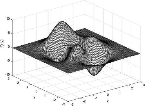
The computational domain of the test surface was and
. The total number of grid cells was 101 × 101, and the grid resolution was 0.06 in both x and y directions. 31 × 31 grid cells were randomly selected as sample points to construct the surface. The sample points were subject to the following errors:
Case 1: Only vertical (z) errors, drawn from the normal distribution N(0,0.02), with a mean of 0 and a variance of 0.02.
Case 2: Only horizontal errors; both x and y coordinates are subject to errors. These errors are drawn from the normal distribution N(0,0.01) with a mean of 0 and a variance of 0.01. Thus, the total error variance in the horizontal was 0.02, which is equal to the vertical in Case 1.
Case 3: Horizontal and vertical errors both drawn from the normal distribution N(0,0.01). The variance of horizontal errors was larger than that of vertical errors.
Case 4: Horizontal and vertical errors drawn from the normal distribution N(0,0.01) and N(0,0.02), respectively. The variance of horizontal errors was equal to that of vertical errors.
Case 5: Horizontal and vertical errors drawn from the normal distributions N(0,0.01) and N(0,0.03), respectively. The variance of horizontal errors was smaller than that of vertical errors.
Root mean square error (RMSE), mean error (ME), and error range (ER; maximum error minus minimum error) were adopted as accuracy measures. RMSE and ME are, respectively, expressed as
where zi and si represent the ith true and simulated values, respectively; and n represents the number of checkpoints.
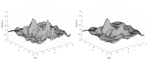
Quantitative statistics () indicate that MQ and MQ-T are more sensitive to horizontal errors than vertical errors under the same variance (i.e., 0.02) in terms of RMSE and ER. For example, from Case 1 to Case 2, the RMSEs of MQ decrease from 0.0627 to 0.1478, whereas those of MQ-T decrease from 0.0621 to 0.1393. This is reasonable when considering that the least squares method is statistically optimal under a normal distribution of vertical errors. In Case 3, when the sample points are subject to both horizontal and vertical errors, the accuracies of the two interpolators are lower than those in Cases 1 and 2 in terms of RMSE and ME. With the increase in vertical error variance from 0.01 in Case 3 to 0.03 in Case 5, MQ and MQ-T return their best and worst results in Cases 4 and 5, respectively. For example, the ERs of MQ and MQ-T in Case 4 are 1.1085 and 1.1804, whereas those in Case 5 are 2.2270 and 1.6714, respectively. This indicates that the increase ratio of ER is 100% for MQ and only 41% for MQ-T. Hence, MQ-T has a high robustness to sampling errors. Irrespective of error distributions in the five cases, MQ-T is more accurate than MQ in terms of RMSE.
Table 1. Accuracy comparison between MQ and MQ-T under different error distributions.
The error surfaces of MQ and MQ-T for Cases 1, 3, and 5 are shown in –, respectively. Regardless of the interpolation method, all surfaces become rougher with increasing error standard deviation. MQ and MQ-T yield similar results for all cases. Comparatively, MQ-T reveals a slightly flatter surface than MQ for Case 5.
Figure 2. Error surfaces of (a) MQ and (b) MQ-T for Case 1.
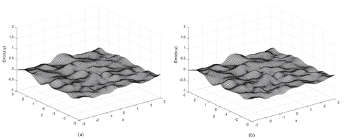
Figure 3. Error surfaces of (a) MQ and (b) MQ-T for Case 3.
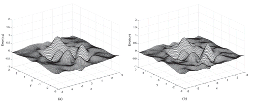
Figure 4. Error surfaces of (a) MQ and (b) MQ-T for Case 5.
3.2 Real-world example
3.2.1 Study site and data collection
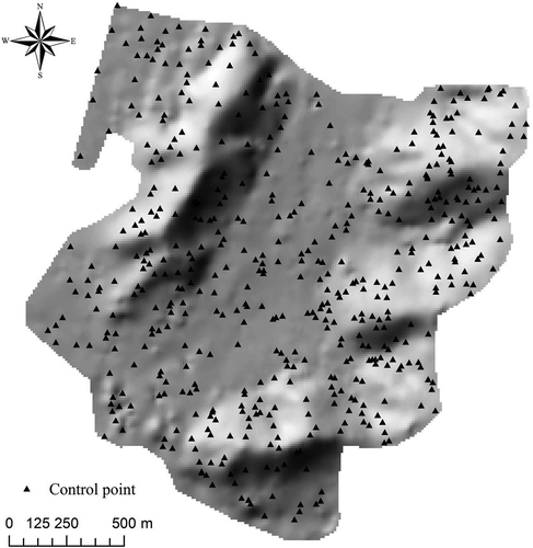
The study area, located in Jinan city, Shandong province, China (36°40′N, 117°00′E), covers an area of 3.36 km2 limited by Mount Taishan to the south and the Yellow River to the north. The elevations range from 109.6 to 364.5 m with a mean elevation of 181.0 m and standard deviation of 51.1 m. To improve the sampling accuracy, 500 control points were first measured () in the study area by using global navigation satellite system real-time kinematic with vertical and horizontal accuracies of 2 and 1 cm, respectively. Then, based on these control points, 5394 points with vertical and horizontal accuracies of 3 and 2 cm, respectively, were collected by a total station instrument with three surveyors. The sampling density was 0.0016 point/m2, and the corresponding sampling interval (SI) was 25 m.
Figure 5. Distribution of the 500 control points in the study site.
3.2.2 Classical interpolation methods
In addition to MQ and MQ-T, classical interpolation methods such as OK, IDW, and ANUDEM were used for DEM construction. OK and IDW belong to smoothing and exact interpolation categories, respectively, and are widely employed in DEM construction (Goovaerts Citation1997; Hutton and Brazier Citation2012). ANUDEM is an interpolation method specifically designed for the creation of hydrologically correct DEMs (Hutchinson Citation1989). For OK, a semivariogram must be manually fitted before performing interpolations. In the present work, OK was conducted by using GS+ geostatistical software. This computer code provides all geostatistical components, including semivariance analysis through kriging and mapping, in a single integrated software program that is well known for its flexibility and user-friendly interface. The interpolation result of IDW depends on the power parameter and the number of neighboring points. The optimal parameters of IDW were selected by using the 10-fold cross-validation technique. For ANUDEM, the value of the vertical standard error parameter is equal to the nugget variance square root of the semivariogram. Both IDW and ANUDEM were performed by using the Spatial Analyst Tools Module of ArcGIS 10.2.
3.2.3 Results
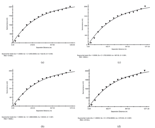
First, four groups of data sets with different SIs were drawn from the original sample points to construct 10-m-resolution DEMs. The relationship between the SI and the number of sample points is depicted in . provides the optimal parameters of IDW, ANUDEM, MQ, and MQ-T under different SIs, and displays the kriging semivariograms.
Table 2. Relationship between the number of sample points and sample interval (SI).
Table 3. Optimal parameters of IDW, ANUDEM, MQ, and MQ-T under different SIs.
Figure 6. Kriging semivariograms fitted with different sample point groups. (a) Semivariogram fitted with 2100 points (i.e., SI = 40 m), (b) semivariogram fitted with 2742 points (i.e., SI = 35 m), (c) semivariogram fitted with 3721 points (i.e., SI = 30 m), and (d) semivariogram fitted with 5394 points (i.e., SI = 25 m).
The 500 control points were used to assess the accuracies of the DEMs. The results, shown in , indicate that irrespective of the interpolation method, the involved accuracy becomes lower in terms of RMSE with an increase in SI. For example, when the SI increases from 25 to 40 m, the RMSEs of IDW, OK, and ANUDEM change from 2.48 to 3.65 m, 1.84 to 2.43 m, and 2.28 to 2.68 m, respectively, whereas the changes in MQ and MQ-T are from 1.73 to 2.38 m and 1.73 to 2.26 m, respectively. Comparatively, MQ and MQ-T have better performances than the classical interpolators for all SIs. Moreover, MQ-T is slightly more accurate than MQ concerning all SIs, except when SI = 25 m. On average, MQ-T has the best performance, closely followed by MQ and OK. Specifically, the RMSEs of IDW, OK, ANUDEM, and MQ are 3.05, 2.22, 2.49, and 2.11 m, respectively, while that of MQ-T is 2.04 m. Namely, the accuracy of MQ-T is about 33.1%, 8.1%, and 18.1% higher than those of IDW, OK, and ANUDEM, respectively.
Table 4. RMSEs of all interpolation methods for 10-m-resolution DEM construction under different SIs in the real-world example (unit: m).
We then investigated the effect of spatial resolution, that is, 40, 30, 20, and 10 m, on the accuracies of the DEMs under SI = 30 m. The results, shown in , indicate that the accuracies of all interpolation methods increase with increasing DEM resolution. Furthermore, MQ-T is more accurate than the classical interpolators. On average, MQ-T produces the best results. Specifically, the RMSEs of IDW, OK, ANUDEM, and MQ are 3.69, 3.28, 3.77, and 3.20 m, respectively, while that of MQ-T is 3.06 m. MQ-T is about 1.21, 1.07, 1.23, and 1.05 times as accurate as IDW, OK, ANUDEM, and MQ, respectively.
Table 5. RMSEs of all interpolation methods for different resolution DEM construction under 30-m SI in the real-world example (unit: m).
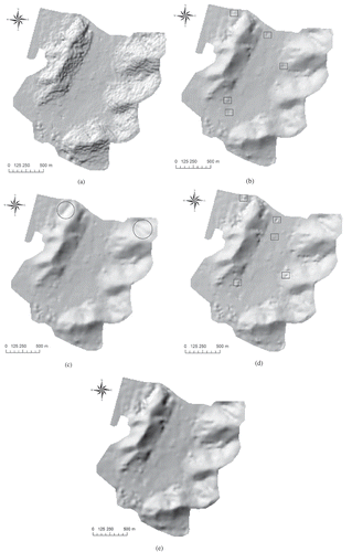
The hillshades of 10-m-resolution DEMs constructed with SI = 35 m are shown in . The results indicate that IDW generates the roughest surface, particularly in the left and right boundary areas. The surfaces of OK and MQ are significantly smoother than that of IDW. However, many isolated pits and artificial mounds are present, as flagged by the rectangles in and . The map of ANUDEM is so smooth that many subtle terrain features disappeared, such as those marked by the circles in . Comparatively, MQ-T produces a better result in which the subtle terrain features are maintained and the artificial pits and mounds are removed.
Figure 7. Hillshades of (a) IDW, (b) OK, (c) ANUDEM, (d) MQ, and (e) MQ-T for 10-m-resolution DEMs constructed with 35-m SI. Isolated pits and artificial mounds are flagged by the rectangles in the maps of OK and MQ. Omitted subtle terrain features are marked by the circles in the map of ANUDEM.
To assess computational cost, we list the computing time of all interpolation methods spent in the construction of 10-m-resolution DEMs with 2100 sample points. A desktop computer with a 64-bit Windows 7 operating system, a quad-core Intel (R) Core™ i7-4790 CPU, 3.6 GHz, and 8 GB memory was used in the experiment. The gathered observations () demonstrate that IDW is the fastest method. This result is expected because IDW is a point-to-point interpolation procedure with no solution of linear systems. ANUDEM is significantly faster than OK, MQ, and MQ-T owing to the very sparse system of linear equations involved in ANUDEM, which can be efficiently solved (Hutchinson Citation1989). MQ-T has the lowest speed because it employs an iterative procedure to smooth both horizontal and vertical errors. OK and MQ solve their systems only once; thus, they are more efficient than MQ-T.
Table 6. Computational costs of all methods for constructing 10-m-resolution DEMs with 2100 sample points (i.e., SI = 40 m).
To reflect the relationship established between DEM error and terrain slope, correlation coefficients between the terrain slopes and interpolation errors for DEMs under SI = 30 m at 500 control points were determined (). In comparison, the interpolation errors of OK have the strongest and weakest correlations with terrain slopes for 40-m- and 10-m-resolution DEMs, respectively. The associated correlation coefficients are 0.588 and 0.310, respectively. On average, IDW and MQ have the weakest and strongest correlations with the values of 0.382 and 0.505, respectively.
Table 7. Correlation coefficients between interpolation errors and terrain slopes for DEMs under 30-m SI.
4 Discussion and conclusions
4.1 Discussion
Thus far, many studies have been conducted to investigate the effect of various factors on the accuracy of DEMs, such as topographic variability, sampling density, interpolation method, and spatial resolution (Anderson, Thompson, and Austin Citation2005; Anderson et al. Citation2006; Guo et al. Citation2010; Liu and Zhang Citation2011; Aguilar et al. Citation2005). All relevant studies agree that morphology has the most significant influence on DEM quality, followed by sampling density and the interpolation method used. Moreover, few differences exist between interpolation methods if the sampling density is high. However, for areas with low sample density, it is very important to select a proper interpolator (Erdogan Citation2009; Chaplot et al. Citation2006; Weber and Englund Citation1992; Lu and Wong Citation2008; Guo et al. Citation2010). In the present investigation, we found that irrespective of sample density, MQ-T is more accurate than IDW, OK, ANUDEM, and MQ for producing DEMs with different resolutions. The high accuracy of MQ-T is related to its ability to smooth both horizontal and vertical errors inherent to sample points. In our study, only one hilly area was employed to validate the efficiency of MQ-T. Considering the significant effect of terrain morphology on DEM accuracy, future research will concentrate on validating the robustness of MQ-T under different landforms.
In our test, the implementation codes of MQ and MQ-T were programed with MATLAB software, which offers ease in solving linear equation systems. We found that MQ-T is significantly slower than the other methods (), because it requires iteratively solving a system of linear equations. Theoretically, the solution of linear equation systems makes MQ-T computationally impossible for large data sets typical of LiDAR-derived files. In practice, we demonstrated that when the number of sample points was 100,000, the MQ-T program could not work with our computer, issuing an out-of-memory warning. This problem can be overcome by performing the function locally. In the process of local interpolation, only those points located in the neighborhood of a given point to be estimated are used to conduct interpolations (Cleveland and Devlin Citation1988); however, the local interpolation scheme may lead to minor discontinuities in the resulting surface. Alternatively, it is possible to conduct a segmentation procedure with a flexible overlapping neighborhood (Mitasova and Hofierka Citation1993). In this method, the interpolation function is performed within a segment using the points located within it and additional points from its neighborhood. This guarantees a smooth connection of segments and is thus an efficient solution of the system of linear equations.
4.2 Conclusions
Stemming from TLS methods for addressing dependent and independent variable errors in linear equation systems, an MQ-T method has been developed in the present work to reduce the effect of both horizontal and vertical errors of sample points on the accuracy of DEMs. Two examples, including a numerical test and a real-world example, were employed to assess the interpolation accuracy of MQ-T. In the numerical test, the performances of MQ-T and MQ for surface modeling were compared under five groups of simulated data sets subject to errors with different distributions. The results showed that irrespective of error distribution, MQ-T is more accurate than MQ in terms of RMSE. The real-world example of DEM construction demonstrated that MQ-T produces better results than both MQ and classical interpolation methods including IDW, OK, and ANUDEM in terms of RMSE regardless of the sample interval and DEM resolution. Therefore, MQ-T can be considered as an alternative method for interpolating sample points subject to both horizontal and vertical errors.
Acknowledgments
This work is supported by National Natural Science Foundation of China [grant number 41371367], [grant number 41101433]; Qingdao Science and Technology Program of Basic Research Project [grant number 13-1-4-239-jch]; SDUST Research Fund; Joint Innovative Center for Safe And Effective Mining Technology and Equipment of Coal Resources, Shandong Province; and Special Project Fund of Taishan Scholars of Shandong Province.
Disclosure statement
No potential conflict of interest was reported by the authors.
Additional information
Funding
References
- Ackermann, F. 1999. “Airborne Laser Scanning—Present Status and Future Expectations.” ISPRS Journal of Photogrammetry and Remote Sensing 54 (2–3): 64–67. doi:10.1016/S0924-2716(99)00009-X.
- Aguilar, F. J., F. Aguera, M. A. Aguilar, and F. Carvajal. 2005. “Effects of Terrain Morphology, Sampling Density, and Interpolation Methods on Grid DEM Accuracy.” Photogrammetric Engineering & Remote Sensing 71 (7): 805–816. doi:10.14358/PERS.71.7.805.
- Anderson, E. S., J. A. Thompson, and R. E. Austin. 2005. “LIDAR Density and Linear Interpolator Effects on Elevation Estimates.” International Journal of Remote Sensing 26 (18): 3889–3900. doi:10.1080/01431160500181671.
- Anderson, E. S., J. A. Thompson, D. A. Crouse, and R. E. Austin. 2006. “Horizontal Resolution and Data Density Effects on Remotely Sensed LIDAR-Based DEM.” Geoderma 132 (3–4): 406–415. doi:10.1016/j.geoderma.2005.06.004.
- Baltsavias, E. P. 1999. “A Comparison between Photogrammetry and Laser Scanning.” ISPRS Journal of Photogrammetry and Remote Sensing 54 (2–3): 83–94. doi:10.1016/S0924-2716(99)00014-3.
- Billings, S. D., G. N. Newsam, and R. K. Beatson. 2002. “Smooth Fitting of Geophysical Data Using Continuous Global Surfaces.” Geophysics 67 (6): 1823–1834. doi:10.1190/1.1527082.
- Blanchard, S. D., J. Rogan, and D. W. Woodcock. 2010. “Geomorphic Change Analysis Using ASTER and SRTM Digital Elevation Models in Central Massachusetts, USA.” GIScience & Remote Sensing 47 (1): 1–24. doi:10.2747/1548-1603.47.1.1.
- Chaplot, V., F. Darboux, H. Bourennane, S. Leguédois, N. Silvera, and K. Phachomphon. 2006. “Accuracy of Interpolation Techniques for the Derivation of Digital Elevation Models in Relation to Landform Types and Data Density.” Geomorphology 77 (1–2): 126–141. doi:10.1016/j.geomorph.2005.12.010.
- Chen, C. F., and Y. Y. Li. 2013. “A Robust Multiquadric Method for Digital Elevation Model Construction.” Mathematical Geosciences 45 (3): 297–319. doi:10.1007/s11004-013-9451-8.
- Chen, C. F., Y. Y. Li, C. Q. Yan, H. L. Dai, and G. L. Liu. 2015. “A Robust Algorithm of Multiquadric Method Based on an Improved Huber Loss Function for Interpolating Remote-Sensing-Derived Elevation Data Sets.” Remote Sensing 7 (3): 3347–3371. doi:10.3390/rs70303347.
- Chirico, P. G., K. C. Malpeli, and S. M. Trimble. 2012. “Accuracy Evaluation of an Aster-Derived Global Digital Elevation Model (GDEM) Version 1 and Version 2 for Two Sites in Western Africa.” GIScience & Remote Sensing 49 (6): 775–801. doi:10.2747/1548-1603.49.6.775.
- Chu, H.-J., C.-K. Wang, M.-L. Huang, -C.-C. Lee, C.-Y. Liu, and -C.-C. Lin. 2014. “Effect of Point Density and Interpolation of Lidar-Derived High-Resolution Dems on Landscape Scarp Identification.” GIScience & Remote Sensing 51 (6): 731–747. doi:10.1080/15481603.2014.980086.
- Cleveland, W., and S. Devlin. 1988. “Locally Weighted Regression: An Approach to Regression Analysis by Local Fitting.” Journal Of The American Statistical Association 83 (403): 596–610. doi:10.1080/01621459.1988.10478639.
- DeWitt, J., T. Warner, and J. Conley. 2015. “Comparison of DEMS Derived from USGS DLG, SRTM, a Statewide Photogrammetry Program, ASTER GDEM and Lidar: Implications for Change Detection.” GIScience & Remote Sensing 52 (2): 179–197. doi:10.1080/15481603.2015.1019708.
- Erdogan, S. 2009. “A Comparision of Interpolation Methods for Producing Digital Elevation Models at the Field Scale.” Earth Surface Processes And Landforms 34 (3): 366–376. doi:10.1002/esp.v34:3.
- Fan, L., J. Smethurst, P. Atkinson, and W. Powrie. 2014. “Propagation of Vertical and Horizontal Source Data Errors into a TIN with Linear Interpolation.” International Journal Of Geographical Information Science 28 (7): 1378–1400. doi:10.1080/13658816.2014.889299.
- Farr, T. G., P. A. Rosen, E. Caro, R. Crippen, R. Duren, S. Hensley, M. Kobrick, M. Paller, E. Rodriguez, and L. Roth. 2007. “The Shuttle Radar Topography Mission.” Reviews of Geophysics 45: RG2004. doi:10.1029/2005RG000183.
- Fisher, P. F., and N. J. Tate. 2006. “Causes and Consequences of Error in Digital Elevation Models.” Progress In Physical Geography 30 (4): 467–489. doi:10.1191/0309133306pp492ra.
- Franke, R. 1982. “Scattered Data Interpolation: Tests of Some Method.” Mathematics Of Computation 38 (4): 181–200.
- Gil, M., M. Arza, J. Ortiz, and A. Ávila. 2014. “DEM Shading Method for the Correction of Pseudoscopic Effect on Multi-Platform Satellite Imagery.” GIScience & Remote Sensing 51 (6): 630–643. doi:10.1080/15481603.2014.988433.
- Golub, G. H., and C. F. Van Loan. 1980. “An Analysis of the Total Least Squares Problem.” SIAM Journal on Numerical Analysis 17 (6): 883–893. doi:10.1137/0717073.
- Gómez, M. F., J. D. Lencinas, A. Siebert, and G. M. Díaz. 2012. “Accuracy Assessment of ASTER and SRTM Dems: A Case Study in Andean Patagonia.” GIScience & Remote Sensing 49 (1): 71–91. doi:10.2747/1548-1603.49.1.71.
- Goovaerts, P. 1997. Geostatistics for Natural Resources Evaluation. USA: Oxford University Press.
- Grohmann, C. H., and S. S. Steiner. 2008. “SRTM Resample with Short Distance-Low Nugget Kriging.” International Journal Of Geographical Information Science 22 (8): 895–906. doi:10.1080/13658810701730152.
- Guo, Q., W. Li, H. Yu, and O. Alvarez. 2010. “Effects of Topographic Variability and Lidar Sampling Density on Several DEM Interpolation Methods.” Photogrammetric Engineering & Remote Sensing 76 (6): 701–712. doi:10.14358/PERS.76.6.701.
- Hoerl, A. E., and R. W. Kennard. 1970. “Ridge Regression: Biased Estimation for Nonorthogonal Problems.” Technometrics 12 (1): 55–67. doi:10.1080/00401706.1970.10488634.
- Höhle, J. 2013. ““Assessing the Positional Accuracy of Airborne Laser Scanning in Urban Areas..” The Photogrammetric Record 28 (142): 196–210. doi:10.1111/phor.12013.
- Hutchinson, M. F. 1989. “A New Procedure for Gridding Elevation and Stream Line Data with Automatic Removal of Spurious Pits.” Journal Of Hydrology 106 (3–4): 211–232. doi:10.1016/0022-1694(89)90073-5.
- Hutchinson, M. F. 2009. “Locally Adaptive Gridding of Noisy High Resolution Topographic Data.” In 18th World IMACS Congress and MODSIM09 International Congress on Modelling and Simulation, Cairns, edited by R. Anderssen, R. Braddock, and L. T. Newham. Canberra: Modelling and Simulation Society of Australia and New Zealand.
- Hutchinson, M. F., and J. C. Gallant. 2000. “Digital Elevation Models and Representation of Terrain Shape.” In Terrain Analysis: Principles and Applications, edited by J. P. Wilson and J. C. Gallant, 29–50. New York, NY: Wiley.
- Hutchinson, M. F., and P. E. Gessler. 1994. “Splines — More than Just a Smooth Interpolator.” Geoderma 62 (1–3): 45–67. doi:10.1016/0016-7061(94)90027-2.
- Hutton, C., and R. Brazier. 2012. “Quantifying Riparian Zone Structure from Airborne Lidar: Vegetation Filtering, Anisotropic Interpolation, and Uncertainty Propagation.” Journal Of Hydrology 442–443 (0): 36–45. doi:10.1016/j.jhydrol.2012.03.043.
- Kansa, E. J., and R. E. Carlson. 1992. “Improved Accuracy of Multiquadric Interpolation Using Variable Shape Parameters.” Computers & Mathematics With Applications 24 (12): 99–120. doi:10.1016/0898-1221(92)90174-G.
- Kellndorfer, J., W. Walker, L. Pierce, C. Dobson, J. A. Fites, C. Hunsaker, J. Vona, and M. Clutter. 2004. “Vegetation height estimation from Shuttle Radar Topography Mission and National Elevation Datasets.” Remote Sensing Of Environment 93 (3): 339–358. doi:10.1016/j.rse.2004.07.017.
- Lee, B. K., K. Yu, and M. Pyeon. 2003. “Effective Reduction of Horizontal Error in Laser Scanning Information by Strip-Wise Least Squares Adjustments.” ETRI Journal 25 (2): 109–120. doi:10.4218/etrij.03.0102.0212.
- Liu, X., and Z. Zhang. 2011. “Effects of Lidar Data Reduction and Breaklines on the Accuracy of Digital Elevation Model.” Survey Review 43 (323): 614–628. doi:10.1179/003962611X13117748892317.
- Lu, G. Y., and D. W. Wong. 2008. “An Adaptive Inverse-Distance Weighting Spatial Interpolation Technique.” Computers & Geosciences 34 (9): 1044–1055. doi:10.1016/j.cageo.2007.07.010.
- Maas, H.-G. 2003. “Planimetric and Height Accuracy of Airborne Laserscanner Data: User Requirements and System Performance.” Paper presented at the Proceedings.
- Markovsky, I., and S. Van Huffel. 2007. “Overview of Total Least-Squares Methods.” Signal Processing 87 (10): 2283–2302. doi:10.1016/j.sigpro.2007.04.004.
- Mitasova, H., and J. Hofierka. 1993. “Interpolation by Regularized Spline with Tension: II. Application to Terrain Modeling and Surface Geometry Analysis.” Mathematical Geology 25 (6): 657–669. doi:10.1007/BF00893172.
- Müller, J., I. Gärtner-Roer, P. Thee, and C. Ginzler. 2014. “Accuracy Assessment of Airborne Photogrammetrically Derived High-Resolution Digital Elevation Models in a High Mountain Environment.” ISPRS Journal of Photogrammetry and Remote Sensing 98: 58–69. doi:10.1016/j.isprsjprs.2014.09.015.
- Næsset, E. 2015. “Vertical Height Errors in Digital Terrain Models Derived from Airborne Laser Scanner Data in a Boreal-Alpine Ecotone in Norway.” Remote Sensing 7 (4): 4702–4725. doi:10.3390/rs70404702.
- Noh, M.-J., and I. M. Howat. 2015. “Automated Stereo-Photogrammetric DEM Generation at High Latitudes: Surface Extraction with TIN-Based Search-Space Minimization (SETSM) Validation and Demonstration over Glaciated Regions.” GIScience & Remote Sensing 52 (2): 198–217. doi:10.1080/15481603.2015.1008621.
- Rastogi, G., R. Agrawal, and Ajai. 2015. “Bias Corrections of Cartodem Using Icesat-GLAS Data in Hilly Regions.” GIScience & Remote Sensing 52 (5): 571–585. doi:10.1080/15481603.2015.1060923.
- Reinoso, J. F. 2010. “A Priori Horizontal Displacement (HD) Estimation of Hydrological Features When Versioned Dems are Used.” Journal Of Hydrology 384 (1–2): 130–141. doi:10.1016/j.jhydrol.2010.01.017.
- Rodarmel, C., A. Samberg, H. Theiss, and T. Johanesen. 2006. “A Review of the ASPRS Guidlines for the Reporting of Horizontal and Vertical Accuracies in LIDAR Data.” International Archives of Photogrammetry and Remote Sensing spatial Information Sciences 36: 34–39.
- Schaffrin, B., I. Lee, Y. Choi, and Y. Felus. 2006. “Total Least-Squares (TLS) for Geodetic Straight-Line and Plane Adjustment.” Bollettino Di Geodesia E Scienze Affini 65 (3): 141–168.
- Tarolli, P. 2014. “High-Resolution Topography for Understanding Earth Surface Processes: Opportunities and Challenges.” Geomorphology 216: 295–312. doi:10.1016/j.geomorph.2014.03.008.
- Van Niel, T. G., T. R. McVicar, L. Li, J. C. Gallant, and Q. Yang. 2008. “The Impact of Misregistration on SRTM and DEM Image Differences.” Remote Sensing Of Environment 112 (5): 2430–2442. doi:10.1016/j.rse.2007.11.003.
- Vosselman, G. 2012. “Automated Planimetric Quality Control in High Accuracy Airborne Laser Scanning Surveys.” ISPRS Journal of Photogrammetry and Remote Sensing 74: 90–100. doi:10.1016/j.isprsjprs.2012.09.002.
- Weber, D., and E. Englund. 1992. “Evaluation and Comparison of Spatial Interpolators.” Mathematical Geology 24 (4): 381–391. doi:10.1007/BF00891270.
- Wilson, J. P. 2012. “Digital Terrain Modeling.” Geomorphology 137 (1): 107–121. doi:10.1016/j.geomorph.2011.03.012.
- Yue, T.-X., Z.-P. Du, D.-J. Song, and Y. Gong. 2007. “A New Method of Surface Modeling and Its Application to DEM Construction.” Geomorphology 91 (1–2): 161–172. doi:10.1016/j.geomorph.2007.02.006.
- Zandbergen, P. A. 2010. “Accuracy Considerations in the Analysis of Depressions in Medium-Resolution Lidar DEMs.” GIScience & Remote Sensing 47 (2): 187–207. doi:10.2747/1548-1603.47.2.187.