
 ?Mathematical formulae have been encoded as MathML and are displayed in this HTML version using MathJax in order to improve their display. Uncheck the box to turn MathJax off. This feature requires Javascript. Click on a formula to zoom.
Abstract
The aim of this study is to present an automatic approach for olive tree dendrometric parameter estimation from airborne laser scanning (ALS) data. The proposed method is based on a unique combination of the alpha-shape algorithm applied to normalized point cloud and principal component analysis. A key issue of the alpha-shape algorithm is to define the α parameter, as it directly affects the crown delineation results. We propose to adjust this parameter based on a group of representative trees in an orchard for which the classical field measurements were performed. The best value of the α parameter is one whose correlation coefficient of dendrometric parameters between field measurements and estimated values is the highest. We determined crown diameters as principal components of ALS points representing a delineated crown. The method was applied to a test area of an olive orchard in Spain. The tree dendrometric parameters estimated from ALS data were compared with field measurements to assess the quality of the developed approach. We found the method to be equally good or even superior to previously investigated semi-automatic methods. The average error is 19% for tree height, 53% for crown base height, and 13% and 9% for the length of the longer diameter and perpendicular diameter, respectively.
Introduction
Airborne laser scanning (ALS) and terrestrial laser scanning (TLS) have been leading remote sensing techniques utilized in forest management since the 1980s (Nelson, Krabill, and Maclean Citation1984; Bernard et al. Citation1987). A reliable estimation of the dendrometric parameters of individual forest trees over a large area has been feasible since the late 1990s (Hyyppä and Inkinen Citation1999; Brandtberg Citation1999). ALS data is commonly used for the estimation of tree heights (Yu et al. Citation2004; Edson and Wing Citation2011), crown base heights (Popescu and Zhao Citation2008; Vauhkonen Citation2010), crown dimensions (Means et al. Citation2000), crown volume (Hinsley et al. Citation2002; Riaño et al. Citation2004), stem diameter (Popescu Citation2007; Saremi et al. Citation2014), stem volume (Persson, Holmgren, and Söderman Citation2002; Straub and Koch Citation2011), and leaf area index (Pope and Treitz Citation2013; Sabol, Patočka, and Mikita Citation2014). Subsequently, these parameters can be used for indirect estimation of biomass volume (Kankare et al. Citation2013). This allows destructive methods (such as cutting and weighing the pieces of wood) to be avoided (Velázquez-Martí et al. Citation2010).
When estimating the biomass of forests, special attention is paid to trunk parameters, because a significant fraction of the woody biomass of forest trees is concentrated in the trunk (Estornell et al. Citation2014). On the contrary, fruit trees usually have short stems, with their biomass concentrated in the crown (Velázquez-Martí et al. Citation2010). Because of these differences, the allometric functions from biomass estimation using parameters from ALS are significantly different.
Recent studies have shown that residual biomass of agricultural trees can be estimated from dendrometric parameters such as tree height, crown base height, and crown diameters (Velázquez-Martí, Gaibor-Chávez, and Pérez-Pacheco Citation2016). For agricultural trees, a reliable and accurate determination of crown characteristics is of particular interest, because these characteristics are related to the primary function of the plants, i.e. the production of fruits. Large and branchy crowns have a positive influence on the protection and remediation of soil while reducing the impact of rain and other factors causing soil erosion (Rodríguez et al. Citation2008). It is also important to maintain the tree height and crown base height within a defined range in order to facilitate easy access to crops (Estornell et al. Citation2014). In this context, the knowledge of crown dimensions, tree heights, and crown base heights of agricultural trees allows for efficient planning and management of agricultural production.
Most research in agriculture takes advantage of TLS data to estimate dendrometric parameters that are traditionally related to productive characteristics. It allows us to measure growth and predict harvests, to plan pruning and define irrigation requirements, and to precisely dose fertilizers while managing pesticides and other phytosanitary products (Gil et al. Citation2014; Gongal et al. Citation2015; Escolà et al. Citation2016; Rufat et al. Citation2014). These actions directly affect cultivation and allow control of annual vegetation growth. TLS is feasible for detailed small-area surveys with a typical radius of a few tens of meters, maximum (Wang and Weng Citation2013) and allows a 3D vegetation model to be derived (Tymków and Borkowski Citation2010; Kwak et al. Citation2007), but is not suitable for the inventory of an entire orchard.
For efficient management of large areas, it is desirable to estimate the above-mentioned parameters automatically using ALS data. Many automatic methods have been developed in forest science over the last two decades (Hyyppä et al. Citation2008, Vauhkonen et al. Citation2012a; Eysn et al. Citation2015). The primary drawback of developed methods is that the processing parameters optimized for a test area may not be suitable for a stand or data of different characteristics (Zhen, Quackenbush, and Zhang Citation2016; Hadas Citation2015). Therefore, it is still a challenging task to automate dendrometric parameter determination.
Because there has been little research about ALS data application for agricultural management, it is of great importance to investigate whether the algorithms developed for forestry studies are suitable and optimal for agricultural trees. Moreover, agricultural trees are deciduous trees, while the majority of forestry research concerns conifers or mixed stands (e.g. Kaartinen et al. Citation2012) and most algorithms also assume a basic conical crown shape, which is more appropriate for conifers (Ke and Quackenbush Citation2011). Therefore, the algorithms applied to deciduous trees are suitable for tree height estimation, but less successful for tree detection, tree diameter derivation, and volume calculation (Sačkov et al. Citation2016). It is also important to note that different dendrometric parameters are of interest in forestry and agriculture. Forest inventory concentrates on tree identification and estimation of tree height and stem diameter, while crown characteristics (base height, shape, area, and diameters) and tree heights are desired during an orchard inventory. Due to typical irregularity in the crowns of agricultural trees, crown geometry should not be simplified to a circular or spherical shape (Pouliot et al. Citation2002), hence at least two diameters are of interest.
The aim of this study is to present an automatic approach for olive tree dendrometric parameter estimation from ALS data of medium density. We also investigated the accuracy of estimated parameters by comparison to reference data. The proposed approach is a unique combination of alpha-shape algorithms and principal component analysis (PCA). Therefore, we call this strategy AS&PCA for future reference. The first step aims at the identification of trees in ALS data and determination of the 2D crown shape contour using the alpha-shape algorithm. The second step aims at an estimation of dendrometric parameters, including tree height, crown base height, and crown diameters. We also propose to adjust the α parameter of the alpha-shape algorithm, utilizing a group of representative trees in an orchard for which classical field measurements were performed. We implemented the algorithms and processed the data using MATLAB software (Release 2015b, The MathWorks, Inc., Natick, MA, USA).
Materials and methods
Study area
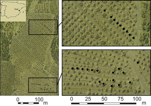
Our study area was a part of an olive orchard located in the West Central area of Spain, in the Castellon province, Viver district, near the city of Valencia (). It is a rectangular 5.92 ha plot with over 1100 olive trees. The morphology of the area is marked by the presence of terraces. The average slope of the terraces where the trees are located is around 3%, and the difference in height among the terraces is around 1.5 m.
Figure 1. Location of the study area, overlap of Light Detection and Ranging (LiDAR) data and orthophoto, olive trees, and the terraces of the study area can be distinguished, sampled trees are in black.
Remote sensing data
The discrete ALS data was collected in September 2012. Detailed characteristics of this flight campaign are presented in . The average scanning density was 4 points/m2. Some parts of the study area were covered by overlaying scans, so for these areas the true point cloud density reached 9 points/m2, whereas for the remaining areas it was 3.5 points/m2.
Table 1. ALS capture and instrument specifications.
Additionally, an orthophoto in near-infrared spectrum was available with a nominal resolution of 0.5 m from ©Institut Cartogràfic Valencià of the Valencia region (Spain). This orthophoto provided reference information on approximated tree crown centers. Although the accuracy of centroids was limited by the resolution of the image, the orthophoto can be considered a good approximation for a comparison between the orthophoto-derived crown centroids and those obtained from Light Detection and Ranging (LiDAR) data.
Ground data
Field measurements were performed in October 2012. A set of 25 samples of individual trees was selected and tagged with identifiers (IDs) from 1 to 25. The trees with IDs from 1 to 13 were located inside the area of overlaying scans. For all sample trees, the following parameters were measured by traditional methods used in agriculture: tree height, crown base height (also defined in the literature as stem height), stem diameter, length of the longest crown diameter (referred to in this paper as longer crown diameter), and length of crown diameter perpendicular to the longest one (referred to as shorter crown diameter). Traditional equipment commonly used in forestry, such as a diameter tape and metric pole, was used for the measurements to ensure centimeter-level accuracy. The basic statistics of measured tree parameters for selected trees are presented in . The tree stand is quite homogeneous for tree heights and crown base heights, which allows the filtering out of low vegetation and ground point to be done quite easily by a height threshold. On the other hand, crown diameter varies significantly within the sampled trees.
Table 2. Basic statistics of measured tree parameters.
During the field measurements, 62 points located near the trees were measured with GPS Real Time Kinematic (RTK) technique using the Leica System 1200 receiver (with an accuracy of 2 and 3 cm for horizontal and vertical coordinates, respectively). This measurement campaign was undertaken in order to verify the quality of the digital terrain model, which was subsequently obtained from LiDAR data.
Digital terrain model (DTM) and normalization of point cloud
Using the available ALS point cloud, a DTM was created in LASTools toolbox for ArcGIS 10.1 software as a grid with a resolution of 1 × 1 m. A cell height was calculated as an average height of ground points located inside the cell. The quality of the DTM was assessed by calculating the differences between DTM- and GPS-RTK-derived heights. The root mean square error (RMSE) of residuals with respect to GPS-RTK measurements was equal to 0.13 m.
After generating the DTM, the ALS point cloud was normalized using the DTM in order to determine the relative heights of ALS points with respect to the DTM. This step was necessary for a proper extraction of the tree heights and tree crown base heights, which were measured from the ground directly below the tree.
After the ALS point cloud normalization, we found that less than 5% of the points in the dataset had negative heights above the ground (up to −0.26 m). This indicated a poor quality of generated DTM for some areas. The points with negative relative heights were located on scarps close to terraces, which separate the ground levels in the orchard. Trees selected as samples for this study were located far from these scarps, so that the normalized point clouds could be used in subsequent analyses. Therefore, observed DTM errors in the vicinity of terraces should not have an impact on the determination of dendrometric parameters.
Tree crown delineation
The correct determination of the crown shape of an individual tree is a crucial step that directly affects the final estimates of dendrometric parameters. From a variety of techniques to reconstruct tree crown shape, we selected an alpha-shape algorithm, similar to Vauhkonen et al. (Citation2009, Citation2010). Alpha-shape is a generalized convex hull algorithm (Edelsbrunner, Kirkpatrick, and Seidel Citation1983) that describes the shape of a finite set of points on a plane. The basic alpha-shape algorithm relies on the Delaunay triangulation, in which each triangle edge is characterized with a radius R of the smallest empty circle containing the edge or triangle. The alpha-shape output for a defined α parameter is a set of edges characterized by the radius Ri smaller or equal to the inverse of the α value. An alpha-shape allows the boundary of objects that are represented by a set of points with heterogeneous distribution and low density to be determined. The basic alpha-shape algorithm as well as its modifications like a localized alpha-shape (Fayed and Mouftah Citation2009), a morphological alpha-shape (Lou, Jiang, and Scott Citation2013), and alpha surfaces (Amit, Raskar, and Chellappa Citation2006) have demonstrated the wide potential of this approach and its capability to solve many spatial modeling problems where other algorithms fail. Since 1990, the alpha-shape has also been used in 3D modeling studies (Edelsbrunner and Mücke Citation1994).
An alpha-shape algorithm does not require any seed point, so prior tree top detection is needless for crown delineation (Koch et al. Citation2014). It does not require any assumption about the shape of a crown or introduction of height-scaling factors, which is typical for image segmentation algorithms like region-growing or watershed transformation. While the most advanced algorithms for tree crown delineation require many user-specific parameters that are difficult to optimize (Fang et al. Citation2016), the alpha-shape algorithm is driven by a single parameter only. The disadvantage of the alpha-shape algorithm is that it will lead to omission errors in the case of overlapping crowns, because it will merge crowns into a single contour. Fortunately, due to regular pruning, overlapping crowns are rare in orchards.
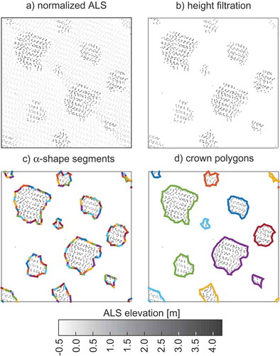
The processing scheme for tree crown delineation is presented in , and the intermediate results are shown in . Tree crown shapes are extracted as polygons from a normalized ALS point cloud. In order to filter out points reflected from the ground or small vegetation, a simple height filtration is performed. All points with a height smaller than the defined hfilter height are removed from further processing. This height should be defined based on an expert knowledge of orchard structure and tree geometry. Then, the classic alpha-shape algorithm is performed on the remaining point cloud, projected onto the xy-plain. The output includes line segments that have to be merged with other segments having a joint vertex in order to obtain polygons. These polygons are assumed to be the contours of the tree crown shape. In the next step, the area of each polygon is calculated. As the quality of DTM over some areas may be poor or the filtration of low vegetation data may prove to be insufficient, we propose to remove polygons having the area smaller than the defined minimum area Amin. The value of Amin should be defined based on an expert knowledge of tree geometry so that the removed polygons can be assumed as artifacts, rather than trees of interest.
Figure 2. The processing scheme for tree crown delineation from the ALS point cloud.
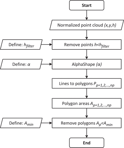
Figure 3. Intermediate results of tree crown delineation for a part of the study area. a) normalized ALS, b) height filtration, c) α-shape segments and d) crown polygons.
The key aspect of the successful performance of cloud delineation with alpha-shape algorithm is the definition of the α parameter. The choice of the optimal value of α depends on the characteristics of ALS data, orchard structure, and tree species. The outputs of the alpha-shape are sensitive to the α value (Hadas, Borkowski, and Estornell Citation2016). In contrast to existing implementations based on the trial-and-error method (Gupta, Weinacker, and Koch Citation2010; Vauhkonen et al. Citation2012b), we propose to adjust the α parameter (and consequently the radius R) based on a group of representative trees in the orchard for which classical field measurements were obtained. The algorithm of adjusting the α parameter that was implemented for this study is shown in .
Figure 4. Algorithm for adjusting the alpha-shape algorithm to field measurements.
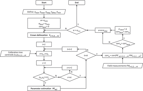
The algorithm seeks the value of α with the step αstep, so that αmin ≤ α ≤ αmax, all defined by the user. The algorithm performs a loop over the α value, and in each loop tree crown delineation is performed. Then, the algorithm tries to join the crown polygons with field measurements of trees. If the field measurements do not include the determination of the horizontal position of tree samples, the geo-reference of each tree can be provided, e.g., from orthophoto as a tree centroid. In this way, a tree centroid is a point with attributes defining field measurements. For each polygon that was successfully joined with a single tree centroid, dendrometric parameters are estimated, as described in the following subsection. The values of estimated parameters are compared with field measurements by calculating the pairwise Pearson’s linear correlation coefficient. In this way, after each step of a loop over α, a correlation coefficient is determined. In the first iteration, the obtained correlation value is considered the best one and the αmin is considered optimal. In the next steps, the correlation coefficient is compared with the best correlation coefficient so far. If the new correlation coefficient value is larger than the best so far, the new one is considered to be the best and the current α is considered optimal.
Tree parameters estimation
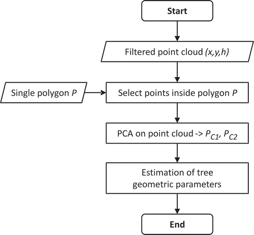
The processing scheme for the estimation of the dendrometric parameters of an individual tree is presented in . It requires the normalized and height-filtered point cloud and a single polygon obtained from tree crown delineation. The normalized point cloud is clipped with the polygon in order to extract ALS data reflected from the tree. Using this sample of ALS data, it is possible to estimate the dendrometric parameters of interest, namely tree height, crown base height, and lengths of longer and shorter crown diameters.
Figure 5. The processing scheme for the estimation of dendrometric parameters.
Tree height is estimated as the height of the highest point in the sample {hi, i = 1,2,…,n}. It is expected that the tree height can be underestimated if none of the reflections comes from the tree top. Tree base height
is estimated as a height of the lowest point in the sample. This parameter can be overestimated if none of the reflections comes from the lowest branch of the tree, but it can be also underestimated if the lowest reflection comes from the trunk or unfiltered low vegetation.
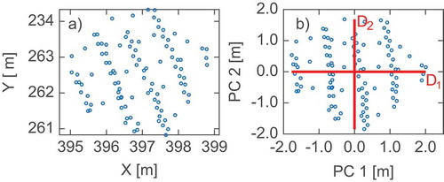
Several approaches can be taken to estimate the diameters of a polygon or a set of points. However, we propose to use the first two components of the PCA as the estimators for crown diameters. PCA is an orthogonal linear transformation of interrelated variables to a new set of uncorrelated variables (new coordinate system), which are called the principal components (PCs) and are arranged in descending order. In our case, only two components are available, because crown diameters are estimated from 2D data. We performed a PCA on ALS points projected onto the plain {xi, yi; i = 1,2,…,n} representing a tree. shows original ALS points and points after transformation into PC domain. Based on the data in the PC domain, the crown diameters are calculated as follows:
Figure 6. ALS points representing a tree: (a) original and (b) in the principal component domain.
PCA decomposition is a simple algorithm and a strict approach in a mathematical sense. Moreover, it allows us to estimate both diameters of a crown, rather than extracting a single diameter from a circle fitted into the crown, thus better reflecting the irregularity of a crown shape typical for agricultural trees.
Validation of the approach
First, we investigated if the α value had any impact on dendrometric parameter estimation. For this purpose, we tested a range of α values from 0.10 to 2.50, and for each α value we determined dendrometric parameters from a selected point cloud with the developed strategy. The number of correctly identified trees as well as the correlation coefficient between estimated and measured dendrometric parameters were used as the diagnostic parameters. Thus, we analyzed the divergence of the α value and the number of correctly detected trees depending on the choice and number of trees used in the adjustment procedure.
In the next step, we applied the cross-validation method that is statistically justified and widely used in geosciences (e.g. Christakos Citation1992). We chose a cross-validation approach to assess the quality of estimated dendrometric parameters from the proposed method. Having n = 25 trees measured in the field, n − 1 trees (all but one) were used to adjust the α value, according to the algorithm presented in . We performed n iterations to adjust the α value, every time neglecting a different tree. In each iteration, the dendrometric parameters for the remaining tree were estimated. After n iterations, every single tree had a set of independently estimated dendrometric parameters. These values were used to calculate the correlation coefficient between estimated and measured metrics in order to assess the accuracy of the proposed method.
Results and discussion
α value impact on results
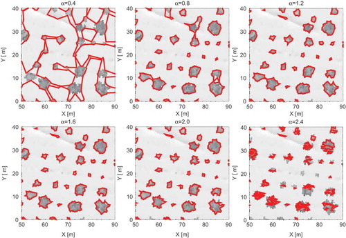
We tested α values from 0.10 to 2.50 (which corresponds to a radius from 10 to 0.4 m) with a step of 0.05. In order to remove ALS terrain points and low vegetation points, a height threshold of 0.5 m was applied and the minimum area for the accepted polygon Amin was set to 0.5 m2.
presents the crown contours obtained with various α values for a part of the study area. We noticed that for a small value of α, single contours contained many trees, and the smaller the α, the more trees were aggregated into a single contour. On the other hand, large values of α resulted in omission errors and many trees were split into smaller contours, while only a narrow range of α resulted in well-delineated contours.
Figure 7. The impact of the α value on crown shape delineation.
) presents the number of identified trees among sampled trees for different α values. We noticed that for the lowest values of α (from 0.10 to 0.20) no trees were identified, because the obtained polygons covered large areas and included several trees (tree centroids) together rather than a single tree. Starting with α = 0.25 up to α = 0.75, the number of detected trees systematically increased up to 24, and remained constant until α = 1.10. For an α value between 1.15 and 2.15, all 25 trees were detected, and for an α value higher than 2.15 the number of detected trees decreased again. This happened because the obtained polygons became too small, so that a single tree was covered by more than a single polygon and the tree centroid was not always located in any of them. In addition, some of the polygons were rejected by the minimum area filter.
Figure 8. (a) Relation between the α parameter value and the number of detected trees and (b) correlation coefficients between estimated parameters and field measurements.
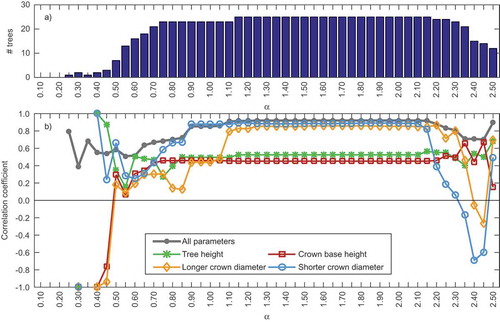
) presents the correlation coefficient between estimated parameters and field measurements for 25 sampled trees for each estimated parameter and all parameters together. The highest values of correlation coefficients were obtained when all sampled trees were detected. However, it should be noted that these values depended on reference (model) values that were erroneous due to limited accuracy of the field measurements.
For an α value between 1.15 and 2.10, the differences between correlation coefficients for each parameter and all parameters together were smaller than 0.01. In this range of α value, the overall correlation coefficient exceeded 0.90, and for both crown diameters it was higher than 0.80 and was close to 0.5 for tree height and crown base height. It can be assumed that the optimum value of the α parameter for the point cloud used in this study was inside this range. When a smaller number of trees were detected, the correlation coefficients got lower, but when only a few trees were detected it was high again.
α value adjustment
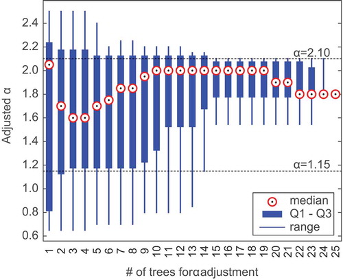
We adjusted the α value using all possible selections of sample trees (33.5 million combinations without repetition in total). presents how an adjusted α value varies depending on the number of trees used in the adjustment procedure. We found that the more trees were used, the more consistent results were obtained. If at least 15 trees were used for adjustment, the adjusted α value fitted into the range of 1.15–2.10, for which the estimated parameters were highly correlated with field measurements. However, if fewer than 15 trees were used for adjustment, for some combinations the adjusted α was incorrect, and the fewer trees were taken for adjustment, the higher the probability of failure was.
Figure 9. α value adjustment results depending on the number of trees used for adjustment.
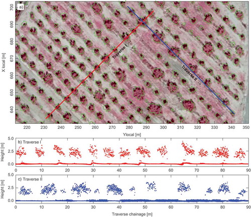
For α = 1.80, which was obtained from an adjustment procedure using all 25 sample trees, we visually assessed crown delineation results with the orthophotomap in a near infrared spectrum ()) as well as with the normalized point cloud (,)). We found a significant agreement of location and size of the crowns in all sources, although the estimated crown shapes seemed to be unnaturally irregular.
Figure 10. Part of the study area: (a) crown contours obtained with α = 1.80 over near-infrared spectrum orthophotomap, (b) and (c) normalized ALS point cloud along two 5 m wide traverses.
Accuracy of tree parameters estimation
Following the validation procedure, we estimated dendrometric parameters for each sample tree with the α value adjusted based on the other 24 sample trees. For a qualitative assessment of our method, we compared the estimated values of dendrometric parameters with field measurements, as well as with two semi-automatic strategies (namely a raw strategy and a raster strategy) applied by Hadas and Estornell (Citation2016). The differences between the previous and current strategies were also in the crown shape and diameter determination methods. The values of estimated tree height, crown base height, crown diameters, and crown area obtained with AS&PCA, along with the two previous strategies and field measurements, are presented in .
Figure 11. Estimated and measured values of tree height, crown base height, crown diameters, and crown area for sampled trees.
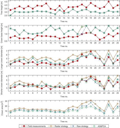
All three strategies resulted in the same estimates for tree height. This was expected, because the top of a tree is usually located in the central part of a crown, so the accurate determination of crown shape is not critical to a reliable estimation of this parameter. However, tree heights were underestimated, with a mean bias of −0.72 m, since there is a small probability of ALS reflection from the top of a tree when the density of point cloud is low. For crown base height, results from AS&PCA were identical to results from the raster data strategy and differed from the raw data strategy only for two trees. The crown base heights from AS&PCA were overestimated, with a mean bias of 0.42 m.
Crown delineation strategy affected the estimation of crown diameters, so the results varied between all methods. For AS&PCA, the length of the longer diameter was usually overestimated, with a mean bias of 0.35 m, but was quite consistent with the results from the raw data strategy. For shorter diameters, the bias for AS&PCA with respect to field measurement was only 0.14 m, and the results were similar to those obtained with the raw data strategy. Due to the lack of field measurements of the crown shape area, it was impossible to assess which strategy provided the best estimates of the crown shape area. Prior studies reported the importance of crown parameters to estimate pruning biomass (Estornell et al. Citation2015). The results obtained in this study encourage us to evaluate this parameter in a more automatic and accurate way. The AS&PCA results were once again quite consistent with the results from the raw data strategy, but the new strategy always provided smaller area estimates.
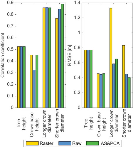
presents the overall assessment of each strategy by means of correlation coefficient with the field measurements and the RMSE with respect to field measurements. For AS&PCA, the correlation coefficient was always the highest among the strategies (0.89 for shorter diameter), or at least as high as for the others (0.53 for tree height, 0.45 for crown base height, and 0.86 for longer diameter). The RMSE of tree heights was equal among the strategies (0.77 m), since all strategies provided the same estimates of tree height. For crown base height, the RMSE for raster data strategy and AS&PCA was equal to 0.46 m and was slightly larger than for raw data strategy, which was equal to 0.45 m. For crown diameters, the raster data strategy performed significantly worse than other strategies (an RMSE of 1.33 m for the longer and 0.83 m for the shorter diameter). For the longer diameter, the RMSE was 0.59 and 0.65 m for the raw data strategy and AS&PCA respectively, while for the shorter diameter AS&PCA was the best, with an RMSE equal to 0.40 m against 0.45 m of an RMSE obtained with a raw data strategy.
Figure 12. (a) Correlation coefficient and (b) RMSE for each strategy and each estimated parameter.
In order to investigate whether the quality of the results was better for trees located inside the area of overlapping scans, we calculated RMSE values for trees 1–13 and trees 14–25 separately (). We noticed that the quality of the results was very similar for crown base height and both diameter estimates, while tree heights were more accurate for trees 1–13. Moreover, in we noticed that the results of α adjustment varied slightly when one of the trees 14–25 was removed, otherwise the α adjustment result remained very stable. Therefore, we can conclude that the higher density of ALS data improves tree height estimation but does not affect the adjustment of the α parameter to extract the crown contour.
Table 3. RMSE values of estimated parameters.
AS&PCA differs from the other strategies mainly in the crown detection algorithm. This is reflected in the estimates of crown diameters, while the tree height and crown base height are almost identical between the strategies. For this reason, we investigated whether the differences between estimated crown diameters are statistically significant or not. With the Shapiro–Wilk test it was found that the crown diameter measurements and estimates were not normally distributed, so the Student’s t-test could not be applied. Instead, we used the Mann–Whitney U test with a significance level of 5% with the null hypothesis – the compared samples do not differ statistically. We compared the results from AS&PCA with field measurements, raster, and raw data strategies (). The test showed that the differences are statistically significant only between AS&PCA and the raster strategy for longer crown diameter estimation. All strategies resulted in statistically similar results for the shorter diameter, and for the longer diameter the results obtained with AS&PCA and the raw strategy are also statistically similar.
Table 4. The p-value of Mann–Whitney U test for the similarity of diameters between strategies.
Conclusions
We have developed and verified an automatic method of ALS data processing for the estimation of the dendrometric parameters of olive trees. The proposed AS&PCA strategy is a combination of alpha-shape and PCA, and is a unique approach for the remote sensing of dendrometric parameters. In order to tune the algorithm, some reference in-situ measurements were needed.
The results of this study indicate the potential of airborne LiDAR data of medium density and alpha-shape algorithm to delineate the crown and extract the dendrometric parameters of olive trees. The method requires field measurements for a selected set of reference trees, in order to adjust the α parameter for the alpha-shape algorithm. We presented that the best estimates of dendrometric parameters can be obtained only within a limited range of the α value. With a cross-validation approach, we have shown that the adjustment algorithm, based on correlation coefficients between estimated and measured parameters, can reliably adjust the value of the α parameter.
We compared the results obtained with this new automatic strategy with the results obtained in previous studies, in which semi-automatic processing was required. For tree heights, the results were the same among all methods. For crown base height, the new strategy was as good as the raster data strategy and better than the raw data strategy. For both crown diameters, the new algorithm was much better than the raster data strategy. It was also better than the raw data strategy in the case of shorter crown diameters, but worse than the raw data strategy in the sense of RMSE for the estimation of the longer diameter. We noticed that the accuracy of estimated parameters with our methods was even better than some results reported in forestry studies for deciduous trees (Popescu, Wynne, and Nelson Citation2003; Kato et al. Citation2009); however, it is highly probable that a less challenging area was investigated in our study.
There are several advantages of this new approach. First, the processing is fully automatic, although it requires some field measurements to adjust the α value. Second, crown diameters are estimated in an optimal way as the first and the second PC. It is a simple method that avoids any more or less complicated approximations. Third, the accuracy of the estimated parameters is equally good or even superior to other methods for most of the estimated parameters, particularly for the length of the longer and perpendicular diameters. The average error is 19% for tree height, 53% for crown base height, and 13% and 9% for the length of the longer and perpendicular diameters, respectively. The methodology developed in this study could be applied in other fruit plantations (as well as almond and nut plantations) to extract individual trees and their main dendrometric parameters, thereby improving the management of these agricultural areas, particularly in the context of precise agriculture.
Disclosure statement
No potential conflict of interest was reported by the authors.
References
- Amit, A., R. Raskar, and R. Chellappa. 2006. “What Is the Range of Surface Reconstructions from a Gradient Field?” Accessed 17 September 2016. http://www.cfar.umd.edu/~aagrawal/eccv06/RangeofSurfaceReconstructions.html
- Bernard, R., D. Vidal-Madjar, F. Baudin, and G. Laurent. 1987. “Nadir Looking Airborne Radar and Possible Applications to Forestry.” IEEE Transactions on Geoscience and Remote Sensing 21 (3): 297–309. doi:10.1016/0034-4257(87)90014-9.
- Brandtberg, T. 1999. “Automatic Individual Tree-based Analysis of High Spatial Resolution Remotely Sensed Data.” PhD diss., Swedish University of Agricultural Sciences.
- Christakos, K. 1992. “Random Field Models in Earth Sciences.” Elsevier Incorporating. doi:10.1016/B978-0-12-174230-0.50001-9.
- Edelsbrunner, H., D. G. Kirkpatrick, and R. Seidel. 1983. “On the Shape of a Set of Points in the Plane.” IEEE Transactions on Information Theory 29 (4): 551–559. doi:10.1109/TIT.1983.1056714.
- Edelsbrunner, H., and E. P. Mücke. 1994. “Three-Dimensional Alpha Shapes.” ACM Transactions on Graphics 13 (1): 43–72. doi:10.1145/174462.156635.
- Edson, C., and M. G. Wing. 2011. “Airborne Light Detection and Ranging (Lidar) for Individual Tree Stem Location, Height, and Biomass Measurements.” Remote Sensing 3 (11): 2494–2528. doi:10.3390/rs3112494.
- Escolà, A., J. A. Martínez-Casasnovas, J. Rufat, J. Arnó, A. Arbonés, F. Sebé, M. Pascual, E. Gregorio, and J. R. Rosell-Polo. 2016. “Mobile Terrestrial Laser Scanner Applications in Precision Fruticulture/Horticulture and Tools to Extract Information from Canopy Point Clouds.” Precision Agriculture 18 (1): 111–132. doi:10.1007/s11119-016-9474-5.
- Estornell, J., L. A. Ruiz, B. Velázquez-Martí, I. López-Cortés, D. Salazar, and A. Fernández-Sarría. 2015. “Estimation of Pruning Biomass of Olive Trees Using Airborne Discrete-Return LiDAR Data.” Biomass and Bioenergy 81: 315–321. doi:10.1016/j.biombioe.2015.07.015.
- Estornell, J., B. Velázquez-Martí, I. López-Cortés, D. Salazar, and A. Fernández-Sarría. 2014. “Estimation of Wood Volume and Height of Olive Tree Plantations Using Airborne Discrete-Return LiDAR Data.” GISciences and Remote Sensing 51 (1): 17–29. doi:10.1080/15481603.2014.883209.
- Eysn, L., M. Hollaus, E. Lindberg, F. Berger, J. M. Monnet, M. Dalponte, M. Kobal, et al. 2015. “A Benchmark of Lidar-Based Single Tree Detection Methods Using Heterogeneous Forest Data from the Alpine Space.” Forests 6 (5): 1721–1747. doi:10.3390/f6051721.
- Fang, F., J. Im, J. Lee, and K. Kim. 2016. “An Improved Tree Crown Delineation Method Based on Live Crown Ratios from Airborne LiDAR Data.” GIScience & Remote Sensing 53 (3): 402–419. doi:10.1080/15481603.2016.1158774.
- Fayed, M., and H. T. Mouftah. 2009. “Localised Alpha-Shape Computations for Boundary Recognition in Sensor Networks.” Ad Hoc Networks 7 (6): 1259–1269. doi:10.1016/j.adhoc.2008.12.001.
- Gil, E., J. Arnó, J. Llorens, R. Sanz, J. Llop, J. R. Rosell-Polo, M. Gallart, and A. Escolà. 2014. “Advanced Technologies for the Improvement of Spray Application Techniques in Spanish Viticulture: An Overview.” Sensors 14 (1): 691–708. doi:10.3390/s140100691.
- Gongal, A., S. Amatya, M. Karkee, Q. Zhang, and K. Lewis. 2015. “Sensors and Systems for Fruit Detection and Localization: A Review.” Computers and Electronics in Agriculture 116: 8–19. doi:10.1016/j.compag.2015.05.021.
- Gupta, S., H. Weinacker, and B. Koch. 2010. “Comparative Analysis of Clustering-Based Approaches for 3-D Single Tree Detection Using Airborne Fullwave LiDAR Data.” Remote Sensing 2: 968–989. doi:10.3390/rs2040968.
- Hadas, E. 2015. “An Overview of Methods for Tree Geometric Parameter Estimation from ALS Data in the Context of Their Application for Agricultural Trees.” Acta Scientarum Polonorum Geodesia Et Descripto Terrarum 14(3–4): 5–28. ISSN .
- Hadas, E., A. Borkowski, and J. Estornell. 2016. “Algorithm for the Automatic Estimation of Agricultural Tree Geometric Parameters Using Airborne Laser Scanning Data.” The International Archives of the Photogrammetry, Remote Sensing and Spatial Information Sciences XLI-B8: 629–632. doi:10.5194/isprs-archives-XLI-B8-629-2016.
- Hadas, E., and J. Estornell. 2016. “Accuracy of Tree Geometric Parameters Depending on the LiDAR Data Density.” European Journal of Remote Sensing 49: 73–92. doi:10.5721/EuJRS20164905.
- Hinsley, S., R. Hill, D. Gaveau, and P. Bellamy. 2002. “Quantifying Woodland Structure and Habitat Quality for Birds Using Airborne Laser Scanning.” Functional Ecology 16 (6): 851–857. doi:10.1046/j.1365-2435.2002.00697.x.
- Hyyppä, H., D. Leckie, F. Gougeon, X. Yu, and M. Maltamo. 2008. “Review of Methods of Small-Footprint Airborne Laser Scanning for Extracting Forest Inventory Data in Boreal Forests.” International Journal of Remote Sensing 29 (5): 1339–1366. doi:10.1080/01431160701736489.
- Hyyppä, J., and M. Inkinen. 1999. “Detecting and Estimating Attributes for Single Trees Using Laser Scanner.” Photogrammetric Journal of Finland 16: 27–42.
- Kaartinen, H., J. Hyyppä, M. Vastaranta, H. Hyyppä, A. Kukko, M. Halapoinen, C. H. Heipke, et al. 2012. “An International Comparison of Individual Tree Detection and Extraction Using Airborne Laser Scanning”. Remote Sensing 4: 950:974. 10.3390/rs4040950.
- Kankare, V., M. Räty, X. Yu, M. Holopainen, M. Vastaranta, T. Kantola, J. Hyyppä, H. Hyyppä, P. Alho, and R. Viitala. 2013. “Single Tree Biomass Modelling Using Airborne Laser Scanning.” ISPRS Journal of Photogrammetry Remote Sensing 85: 66–73. doi:10.1016/j.isprsjprs.2013.08.008.
- Kato, A., L. M. Moskal, P. Schiess, M. E. Swanson, D. Calhoun, and W. Stuetzle. 2009. “Capturing Tree Crown Formation through Implicit Surface Reconstruction Using Airborne Lidar Data.” Remote Sensing of Environment 113 (6): 1148–1162. doi:10.1016/j.rse.2009.02.010.
- Ke, Y., and L. J. Quackenbush. 2011. “A Review of Methods for Automatic Individual Tree Crown Detection and Delineation from Passive Remote Sensing.” International Journal of Remote Sensing 32: 4725–4747. doi:10.1080/01431161.2010.494184.
- Koch, B., T. Kattenborn, C. Straub, and J. Vauhkonen. 2014. Forestry Applications of Airborne Laser Scanning. Dordrecht: Springer.
- Kwak, D. A., W. K. Lee, J. H. Lee, G. S. Biging, and P. Gong. 2007. “Detection of Individual Trees and Estimation of Tree Height Using LiDAR Data.” Journal of Forest Research 12 (6): 425–434. doi:10.1007/s10310-007-0041-9.
- Lou, S., X. Jiang, and P. J. Scott. 2013. “Application of the Morphological Alpha Shape Method to the Extraction of Topographical Features from Engineering Surfaces.” Measurements 46 (2): 1002–1008. doi:10.1016/j.measurement.2012.09.015.
- Means, J., S. Acker, B. Fitt, M. Renslow, L. Emerson, and C. Hendrix. 2000. “Predicting Forest Stand Characteristics with Airborne Scanning Lidar.” Photogrammetric Engineering and Remote Sensing 66 (11): 1367–1371.
- Nelson, R., W. Krabill, and G. Maclean. 1984. “Determining Forest Canopy Characteristics Using Airborne Laser Data.” Remote Sensing of Environment 15 (3): 201–212. doi:10.1016/0034-4257(84)90031-2.
- Persson, Å., J. Holmgren, and U. Söderman. 2002. “Detecting and Measuring Individual Trees Using an Airborne Laser Scanner.” Photogrammetric Engineering and Remote Sensing 68 (9): 925–932.
- Pope, G., and P. Treitz. 2013. “Leaf Area Index (LAI) Estimation in Boreal Mixedwood Forest of Ontario, Canada Using Light Detection and Ranging (Lidar) and WorldView-2 Imagery.” Remote Sensing 5 (10): 5040–5063. doi:10.3390/rs5105040.
- Popescu, S. C. 2007. “Estimating Biomass of Individual Pine Trees Using Airborne Lidar.” Biomass and Bioenergy 31 (9): 646–655. doi:10.1016/j.biombioe.2007.06.022.
- Popescu, S. C., R. H. Wynne, and R. F. Nelson. 2003. “Measuring Individual Tree Crown Diameter with LiDAR and Assessing Its Influence on Estimating Forest Volume and Biomass..” Canadian Journal of Remote Sensing 29 (5): 564–577. doi:10.5589/m03-027.
- Popescu, S. C., and K. Zhao. 2008. “A Voxel-Based Lidar Method for Estimating Crown Base Height for Deciduous and Pine Trees.” Remote Sensing of Environment 112 (3): 767–781. doi:10.1016/j.rse.2007.06.011.
- Pouliot, D. A., D. J. King, F. W. Bell, and D. G. Pitt. 2002. “Automated Tree Crown Detection and Delineation in High-Resolution Digital Camera Imagery of Coniferous Forest Regeneration.” Remote Sensing of Environment 82 (2–3): 322–334. doi:10.1016/S0034-4257(02)00050-0.
- Riaño, D., F. Valladares, S. Condés, and E. Chuvieco. 2004. “Estimation of Leaf Area Index and Covered Ground from Airborne Laser Scanner (Lidar) in Two Contrasting Forests.” Agricultural and Forest Meteorology 124 (3–4): 269–275. doi:10.1016/j.agrformet.2004.02.005.
- Rodríguez, R., S. Valencia, J. Meza, M. Capó, and A. Reynoso. 2008. “Crecimiento Y Caracterı´Sticas De La Copa De Procedencias De Pinus Gregii Engelm.” Fitotecnia 31 (1): 19–26.
- Rufat, J., J. M. Villar, M. Pascual, V. Falguera, and A. Arbonés. 2014. “Productive and Vegetative Response to Different Irrigation and Fertilization Strategies of an Arbequina Olive Orchard Grown under Super-Intensive Conditions.” Agricultural Water Management 144: 33–4162.doi:10.1016/j.agwat.2014.05.014
- Sabol, J., Z. Patočka, and T. Mikita. 2014. “Usage of LiDAR Data for Leaf Area Index Estimation.” GeoScience Engineering 60 (3): 10–18. doi:10.2478/gse-2014-0013.
- Sačkov, I., G. Santopuoli, T. Bucha, B. Lasserre, and M. Marchetti. 2016. “Forest Inventory Attribute Prediction Using Lightweight Aerial Scanner Data in a Selected Type of Multilayered Deciduous Forest.” Forests 7: 307. doi:10.3390/f7120307.
- Saremi, H., L. Kumar, C. Stone, G. Melville, and R. Turner. 2014. “Sub-Compartment Variation in Tree Height, Stem Diameter and Stocking in a Pinus radiata D. Don Plantation Examined Using Airborne LiDAR Data.” Remote Sensing 6 (8): 7592–7609. doi:10.3390/rs6087592.
- Straub, C., and B. Koch. 2011. “Estimating Single Tree Stem Volume of Pinus sylvestris Using Airborne Laser Scanner and Multispectral Line Scanner Data.” Remote Sensing 3 (12): 929–944. doi:10.3390/rs3050929.
- Tymków, P., and A. Borkowski. 2010. “Vegetation Modelling Based on TLS Data for Roughness Coefficient Estimation in River Valley.” International Archives of the Photogrammetry, Remote Sensing and Spatial Information Science XXXVIII (8): 309–313.
- Vauhkonen, J. 2010. “Estimating Crown Base Height for Scots Pine by Means of the 3D Geometry of Airborne Laser Scanning Data.” International Journal of Remote Sensing 31 (5): 1213–1226. doi:10.1080/01431160903380615.
- Vauhkonen, J., L. Ene, S. Gupta, J. Heinzel, J. Holmgren, J. Pitkänen, S. Solberg, et al. 2012a. “Comparative Testing of Single-Tree Detection Algorithms under Different Types of Forest.” Forests 85: 27–40. doi:10.1093/forestry/cpr051.
- Vauhkonen, J., I. Korpela, M. Maltamo, and T. Tokola. 2010. “Imputation of Single-Tree Attributes Using Airborne Laser Scanning-Based Height, Intensity, and Alpha Shape Metrics.” Remote Sensing of Environment 114: 1263–1276. doi:10.1016/j.rse.2010.01.016.
- Vauhkonen, J., A. Seppänen, P. Packalén, and T. Tokola. 2012b. “Improving Species-Specific Plot Volume Estimates Based on Airborne Laser Scanning and Image Data Using Alpha Shape Metrics and Balanced Field Data.” Remote Sensing of Environment 124: 534–541. doi:10.1016/j.rse.2012.06.002.
- Vauhkonen, J., T. Tokola, P. Packalén, and M. Maltamo. 2009. “Identification of Scandinavian Commercial Species of Individual Trees from Airborne Laser Scanning Data Using Alpha Shape Metrics.” Forest Science 55: 37–47.
- Velázquez-Martí, B., E. Fernández-González, J. Estornell, and L. A. Ruiz. 2010. “Dendrometric and Dasometric Analysis of the Bushy Biomass in Mediterranean Forests.” Forest Ecology and Management 259 (5): 875–882. doi:10.1016/j.foreco.2009.11.027.
- Velázquez-Martí, B., J. Gaibor-Chávez, and S. Pérez-Pacheco. 2016. “Quantification Based on Dimensionless Dendrometry and Drying of Residual Biomass from the Pruning of Orange Trees in Bolivar Province (Ecuador).” Biofuels, Bioproducts and Biorefining 10: 175–185. doi:10.1002/bbb.1635.
- Wang, G., and Q. Weng. 2013. Remote Sensing of Natural Resources: Comparison of Airborne, Mobile, and Terrestrial Laser Scanning. Boca Raton: CRC Press.
- Yu, X., J. Hyyppä, H. Kaartinen, and M. Maltamo. 2004. “Automatic Detection of Harvested Trees and Determination of Forest Growth Using Airborne Laser Scanning.” Remote Sensing of Environment 90 (4): 451–462. doi:10.1016/j.rse.2004.02.001.
- Zhen, Z., L. J. Quackenbush, and L. Zhang. 2016. “Trends in Automatic Individual Tree Crown Detection and Delineation—Evolution of LiDAR Data.” Remote Sensing 8 (4): 333. doi:10.3390/rs8040333.