
Abstract
Due to road construction, the University Museum of Bergen conducted a rescue excavation in Vika, Bømlo County, some 5 km from the large greenstone quarry Hespriholmen on the Norwegian west coast. The site revealed two distinct occupation phases. In the Early Mesolithic (10,500–11,000 cal BP), Vika was a small hunting station, while in the Late Mesolithic (8000–7000 cal BP), Vika served as a specialized workshop site for the production of adze preforms out of blanks shipped from the Hespriholmen quarry. Because of the mid-Holocene transgression, most of the archaeological record was covered by a beach ridge at the Vika site. The build up of the ridge is described by conducting a series of radiocarbon datings and by analyzing the distribution of reworked and non-reworked lithics throughout the different strata of the beach sediments. The paper emphasizes the potential for obtaining significant results despite the absence of in-situ archaeological remains and their exposure to redeposition. The Vika site provided valuable insights into the displacements of shorelines, characteristics of beach ridges, and the influence of the dynamic Holocene environment on Mesolithic sites along the coast.
Introduction
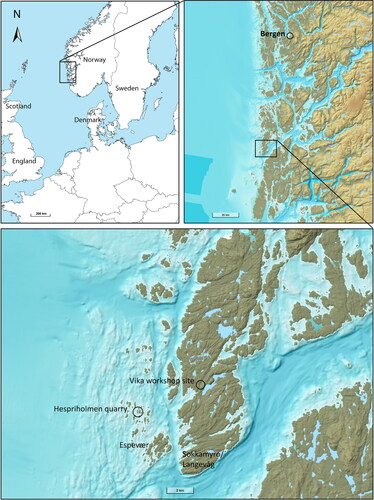
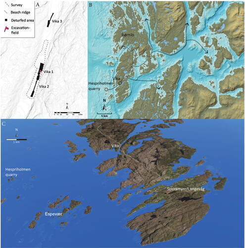
The transition from the Pre-Boreal to the Boreal chronozone in Scandinavia brought about significant changes in flora and fauna and witnessed the highest tree cover since deglaciation in the coastal areas of southern Norway (Hjelle et al. Citation2018). These changes are also reflected in the lithic tool industry, which in the transition from the Early Mesolithic (EM) to the Middle Mesolithic (MM), developed into a greater variety of shapes and forms (e.g., Bjerck Citation2008; Sørensen et al. Citation2013). In western Norway, implements made from local raw materials became a vital part of the inventory. The encroaching boreal forest demanded new types of tools, and one of the most profound changes was the polished or pecked chubby adzes made of hard basaltic rock found in high numbers at sites from the Late Mesolithic (LM). Besides being important tools for performing tree-related work, they are also believed to have played vital roles in social and economic networks (Bergsvik and Olsen Citation2003; Nyland Citation2017). A significant proportion of these adzes were made using raw materials mined from quarries located along the coast (Nyland Citation2020; Olsen and Alsaker Citation1984). The quarries at Hespriholmen, in particular, provided greenstone used for adze production during the Mesolithic and Neolithic periods. While previous research has focused on greenstone workshop sites located in Langevåg, Sokkamyro, and the Espevær islands (Alsaker Citation1987), this paper presents new data from a previously unknown site named Vika on mainland Bømlo ().
Figure 1. Map of the region, showing the Norwegian West Coast and Bømlo with some of the locations mentioned in the text.
By examining the formation processes and environmental context of Vika, this study sheds light on the broader implications of marine foragers and the dynamics of raw material extraction and tool production in a changing land and seascape. To illustrate the formation processes and the environment that humans faced during the occupation of this site, three important backdrops are presented.
Backdrop 1: Post-glacial shoreline displacements
Studies on post-glacial sea-level fluctuation have a 100-year-long research history in western Norway (Fægri Citation1944; Kaland Citation1984; Lohne et al. Citation2007; Prøsch-Danielsen Citation2006; Shetelig Citation1920; Simpson Citation2009; Svendsen and Mangerud Citation1987) and shoreline displacements are an important tool post- and pre-dating shore bound activity. In the Bømlo area, the marine limit (i.e., the maximum height of the post-glacial sea level) is calculated to have been 36 masl at 12,000 cal BP (Kaland Citation1984). Due to the isostatic rebound caused by the deglaciation of the Scandinavian ice sheet in the early Holocene (Hughes et al. Citation2016), the relative sea level (RSL) fell rapidly to approximately 3 masl at 10,000 cal BP ().
Figure 2. Shoreline displacement curve for Vika (red) and Hespriholmen quarry (blue). The curve is constructed from Kaland (Citation1984), Lohne et al. (Citation2007), Romundset (Citation2005), Simpson (Citation2009), and Vasskog (Citation2006).
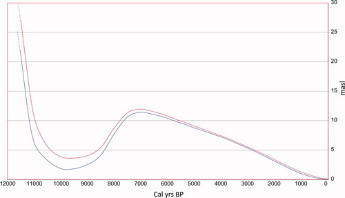
From about 10,000 to 7000 cal BP sea level rose rapidly and covered the settlement at Vika (known as the “Tapes” transgression). Since the time of maximum transgression, there has been a continuous regression until the present (Kaland Citation1984; Lohne et al. Citation2007; Romundset Citation2005; Vasskog Citation2006). Except for the rapid regression between 11,500 and 11,000 cal BP, the sea-level fluctuation would hardly have been noticeable for the population. The RSL had, however, a profound long-term impact on where it was possible to reside and a strong effect on what kind of remains are preserved in the archaeological record. The latter is especially important as the Tapes transgression has affected the majority of marine settlements between 11,000 and 7500 cal BP in the outer coastal areas of western Norway (Bjerck Citation1982; Bondevik et al. Citation2019). The method for extrapolating sea-level curves for the region of Bømlo is based on Lundström, Simpson, and Yaworsky (CitationForthcoming), and Simpson (Citation2009).
Backdrop 2: Bømlo—the affluent lithic distribution center
Bømlo is a municipality situated on the coast of western Norway consisting of 900 small and large islands. Exposed to the North Sea, the weather conditions can be rough; however, the numerous small skerries and islands offer protection against waves and wind. Due to the Norwegian Current, which carries warm waters along the coast, the climate in western Norway is oceanic and recognized by mild winters, cool summers, and high rates of precipitation. The seascape on this part of the coast is a mosaic of inlets, shallow waters, tidal currents, and a large subtidal zone, all of which are known to be rich in marine resources. Even today, this area is attractive among anglers, and fishing is important for professionals as well as the tourist industry.
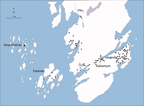
The geology of Bømlo is complex but comprises mainly Caledonian Metabasalt and a variety of pyroclastic and metamorphic rocks. Two types of rock, however, had particular importance during the Stone Age: rhyolite and greenstone. Rhyolite is an extrusive eruptive rock that was collected on Bømlo’s highest mountain (Siggjo). It has some of the same qualities as flint and was mainly utilized for projectiles and knives in the Early and Middle Neolithic periods from 6000 to 4300 cal BP (Bergsvik Citation2002). Greenstone, in comparison, is a metamorphosed igneous basaltic rock and was utilized from the Middle Mesolithic (9000 cal BP) to the Middle Neolithic (5000 cal BP) to produce picked or polished adzes. Because of the comprehensive scale of extraction and movement of various items and raw materials, Bømlo has been labeled a Stone Age “distribution center” (Alsaker Citation1987; Olsen and Alsaker Citation1984). The abundant supply of high-quality raw materials and the thriving marine environment have likely led to Bømlo having one of the highest concentrations of Stone Age sites in Norway (Alsaker Citation1987; Bergsvik et al. Citation2020) ().
Figure 3. Distribution of Mesolithic and Neolithic workshop sites in the Southern part of Bømlo (after Alsaker Citation1987). The Vika site is in the north.
Backdrop 3: The Hespriholmen greenstone quarry—volume, age, and interpretation
Situated on a remote islet around 5 km offshore, the massive greenstone quarry of Hespriholmen is one of the most profound cultural heritages in western Norway (). The site was identified in 1923 and was the first prehistoric quarry to be found in Norway. Greenstone of good quality can also be easily found on mainland Bømlo, and indeed a few small quarries have been recorded there (Alsaker Citation1987; Nyland Citation2017). However, these are insignificant in volume compared to the Hespriholmen quarry, and the question of why people chose to make the journey to this isolated group of islands 5 km offshore to collect greenstone has perplexed archaeologists and geologists ever since its discovery. The hypotheses have alternated between strictly “functionalistic” explanations, where the quality of the greenstone alone was believed to be the reason (Alsaker Citation1987; Hagen Citation1983; Olsen and Alsaker Citation1984), to a social and “idealistic” point of view, where contextual and cosmological aspects (i.e., the remote localization and dangerous journey; see Bergsvik (Citation2002)), or the place itself (Nyland Citation2020), that people might have believed was imbued with certain powers or enhanced the value of the items.
Figure 4. (A) The main distribution of Hespriholmen greenstone adzes is from Sognefjorden in the north to Agder in the south (after Alsaker Citation1987). (B) Closeup of greenstone from Hespriholmen. Note the distinct yellow veinlets of epidote (photo: Leif Inge Åstveit). (C) A polished chubby adze made of Hespriholmen greenstone also with visible veinlets of epidote (photo: Bergen University Museum). (D) The quarry seen from the sea surface. The floor is completely leveled and is 4.7 masl (photo: Leif Inge Åstveit). (E) The floor in the main quarry seen from above (photo: Leif Inge Åstveit). (F) Map of Hespriholmen. The quarry is measured to be 18 m wide. (G) The shoreline displacement curve from Hespriholmen combined with a transect of the islet and summed calibrated dates from Vika. While the flint artifacts were deposited during the regression (i.e., approximately 10,500–11,000 BP), the greenstone was deposited during the transgression probably between 8000 and 7000 BP. The main floor in the quarry was dry land from 9900 to 8400 BP and submerged between 8400 and 2900 BP (transect from Alsaker Citation1987).
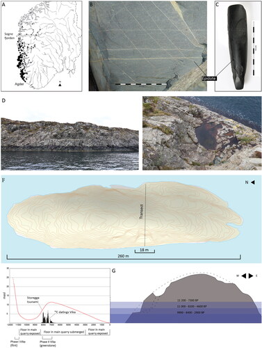
Hespriholmen consists of one main quarry and several smaller adjacent ones. At its greatest extent, the main quarry is roughly 18 m wide, 15 m high, and 9 m deep. It has a flat surface in the lowermost areas known as the “floor.” A peak of unextracted greenstone at the full height separates the main quarry in two. This remnant could have something to do with the mining process, although it is difficult to tell exactly how the extraction was carried out. Morphologically, the greenstone from Hespriholmen is detectable because of the hair-thin yellow veinlets of epidote (). Geochemical and petrographic analysis (Alsaker Citation1987; Bergsvik Citation2006) confirm the hypothesis that greenstone from this quarry has a wide distribution, at least from Agder in the South to Sognefjorden in the North () (Bergsvik and Olsen Citation2003; Olsen and Alsaker Citation1984).
Efforts to quantify the volume of quarrying at Hespriholmen during the Stone Age have yielded varying results. Previous studies have estimated the volume to be as low as 70 m3 (Kolderup Citation1925) and as high as over 1000 m3 (Hagen Citation1983). The most recent attempt by Alsaker (Citation1987) suggests that the main quarry accounted for approximately 350 m3 of extraction, with an additional 77 m3 from smaller quarries on the islet. According to Alsaker’s findings, around 280 m3 of the total volume remains in the waste pile at the seabed in front of the quarry, while another 29 m3 is scattered in waste piles on the islet. From these estimates, it can be concluded that approximately 118 m3 of greenstone was transported off the islet, representing roughly 30% of the initial extracted volume.
To produce a 3D photogrammetry model of all the quarries at Hespriholmen, I used drones and collected new measurements using GPS (accuracy ±2 cm) in 2016. The floor of the main quarry is situated at 4.7 masl, a height which confirms Alsaker’s (Citation1987) measurement. According to the RSL, it was above the surface level for the first time at approximately 11,000 cal BP and available for mining until 8400 cal BP, after which it was submerged due to the transgression for well over 5000 years (i.e., during most of the Mesolithic; ). The floor became dry land in the Late Neolithic, approximately 2,900 cal BP. It has been suggested that the extraction of greenstone from Hespriholmen began on the uppermost parts of the islet in the EM, approximately 11,500 cal BP, and as new sections of the dyke became available during the regression, the activity continued to lower elevations and finally down to the main floor at approximately 11,000 cal BP (Alsaker Citation1987). However, as pointed out by Nyland (Citation2016), this theory currently has no support due to the total lack of greenstone in convincing EM contexts in western Norway. As the number of investigated EM sites increases (Åstveit Citation2018), the theory of extracting greenstone this early appears to weaken. At the other end of the time scale, it has been suggested that the main quarry is a result of the search for metals when the floor yet again became dry land in the Late Neolithic or Bronze Age (Melheim Citation2015). Although this theory cannot be ruled out per se, it currently lacks empirical support. As the number of excavated sites from all parts of the Stone Age increases on an annual basis (Bergsvik et al. Citation2020), the evidence seems clear that the activity at Hespriholmen started in the MM, approximately 9000 cal BP, and came to an end during the Middle Neolithic (4500 cal BP).
The Vika site
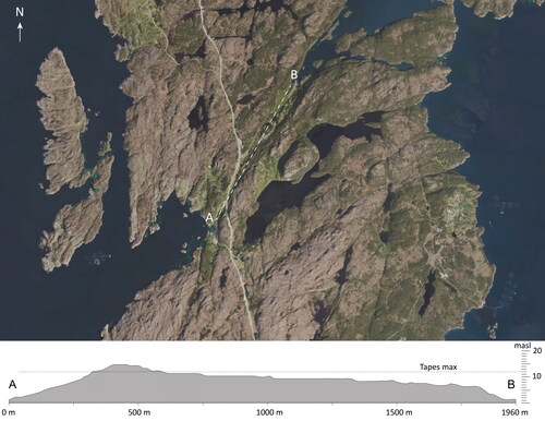
Over the past century, large-scale excavations as well as smaller research projects have been carried out at Bømlo (e.g., Alsaker Citation1987; Årrestad and Warren Citation2001; Kristoffersen Citation1995; Shetelig Citation1901, Citation1922). However, it is noteworthy that investigations into categories of sites other than residential, dwelling, or those related to hunting have only been periodically conducted. Nevertheless, in 2014 and 2015, The University Museum of Bergen investigated three sites in an area named Vika (Vika 1–3) as a rescue excavation due to road construction (Åstveit and Carrasco Citation2016) (). Vika 3 provided valuable information about the deglaciation and sea-level fluctuations in late glacial and early post-glacial times. In this paper, however, only the time of human occupation is presented (i.e., the Late Preboreal and onward). This mainly includes the site Vika 1 (hereafter named Vika). Semantically, Vika denotes “bay” or “inlet” in Norwegian and can also be interpreted as a safe landing spot when traveling along the coast by boat. The excavated area was located 11–12 masl in a narrow valley running northeast–southwest. Today, the site’s surface is used as a pasture; however, with the sea level raised to approximately 8–12 m above present, the site would have been situated on an isthmus bisecting this part of Bømlo and benefitting from having a “double harbor” (i.e., the possibility to land or set ashore from two different directions). In an area frequently visited by stormy weather, we know this feature has been of major importance and a vital requirement for hunter-gatherer-fisher populations (Bjerck Citation1989). A double harbor would have also provided quick access to two very different seascapes: toward the southwest, the open sea, and small islands offshore; toward the northeast, large bodies of calm water, and an archipelago with well-sheltered transport routes.
Figure 5. (A) The site Vika was situated in a narrow valley running North–South. An area of approximately 250 × 60 m was surveyed by test pitting. The top layer of an area of approximately 150 × 15 m was removed by machine. (B) The Bømlo peninsula and possible transport routes from Vika. (C) Southern Bømlo with the sea level raised to 12 m, i.e., the level during maximum transgression. At this time, it is quite clear that Vika together with Sokkamyro/Langevåg was optimal when it comes to communication and thus distribution of adzes (map: Thomas Bruen Olsen).
Methods and materials
Deep trench and archaeological excavation
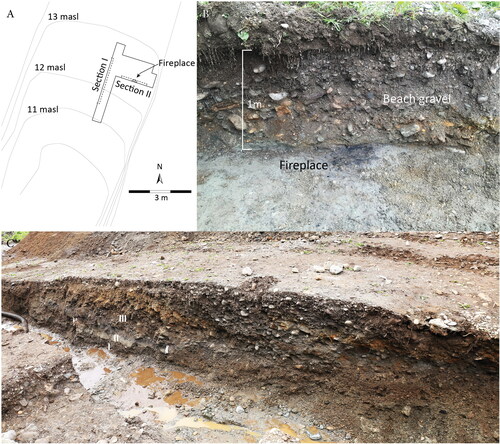
A total area of 2138 m2 was opened and deturfed by a mechanical excavator to search for artifacts and settlement remains (). A 17 m long deep trench (trench 1) was also dug to map the stratigraphy and human occupation at the site. The sections revealed in the trenches further served as opportunities to collect radiocarbon samples. A field of 40 m2 was excavated by hand within units of 50 × 50 × 5 cm adjacent to the trench. A total volume of 13.2 m3 was water-sieved with a 4 mm mesh to collect lithic artifacts. Approximately 10% of the site has been archaeologically excavated.
Figure 6. (A) The excavation field was situated 11–12 masl. Two sections, I and II were documented. (B) Section II: a fireplace consisting of charcoal and fire-cracked stones was dated to 7665–7575 BP. The fireplace was situated on top of fine sand (Unit II) and covered by beach gravels (Unit III) (photo: Leif Inge Åstveit). (C) Section I with three units (I–III) (Unit IV removed). This is a beach ridge gradually built up by waves in a transgressive sequence and has a distinct low angel cross-bed composition. Greenstone was detected all through this unit (photo: Leif Inge Åstveit).
Lithics: Classification and quantity reworked by waves
A total number of 18,429 lithics with a weight of 192.4 kg were collected from the site. The artifacts were recorded in accordance with the Norwegian National Museum’s standards for archaeological material. In this paper, a simplified and abbreviated version of the catalog is presented.
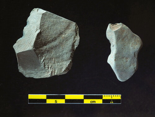
A unit measuring 2 × 1× 0.9 meters in size (1.8 m3) was divided into 18 layers of 5 cm, extending from the top to the bottom of the beach ridge. The entire collection of greenstone lithics, totaling 1227 pieces, retrieved from this unit was thoroughly examined and classified based on whether they displayed signs of reworking (i.e., rounding, resulting from wave action). The aim was to illuminate the process of how the beach ridge had built up during the LM and affected the human occupation. There is, of course, a huge difference in the degree to which the artifacts were reworked, and initially, an attempt was made to divide the reworked greenstone artifacts into four different categories. However, after conducting a blind test among a group of archaeologists, this method was found to be unreliable and too subjective. Alternatively, dividing these into two different categories, namely sharp (V0) (i.e., non-affected and rounded), and V1, mostly flakes (), turned out to provide a consistent result when conducting the same test. It is also believed that this distinction is the most relevant as it reflects the relation between in-situ deposited “sharp” lithics and redeposited material.
Figure 7. Greenstone categories from Vika. Left: category V0, details like hinges, fractures, platforms, and ripples are visible. No sign of being reworked by waves. Right: category V1, no sharp edges or visible ripples, clearly reworked by waves.
Radiocarbon dating
Seventeen radiocarbon samples were selected to help examine site formation processes and the time and nature of human occupation at Vika. Fourteen samples were collected from the cross-section of the beach ridge () and three from superimposed fireplaces in the excavation field ().
Figure 8. Stratigraphy from section I with the different units (I–III) and the position from where the 14 radiocarbon samples were collected.
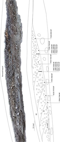
To avoid misdating caused by roots penetrating from the surface, a problem known to occur in similar contexts (Bondevik Citation2003), only carbonized material was submitted for dating (i.e., wood or nutshell, except sample no. 4). Because reliable sample material was not present in all layers of the beach ridge, it was not possible to create a complete top to bottom radiocarbon sequence. All charcoal from the cross-section is believed to be remnants of human activity taking place in the erosional zone at lower levels ahead of the transgression. To avoid the “old wood effect” (Schiffer Citation1986), all samples were identified to species, and as far as was possible, short-lived trees were selected for age determination. Four of the samples are, however, pine (Pinus sp.), which could potentially have a substantial in-built age. Although it is difficult to assess whether this was an issue, the pine samples did not produce anomalous ages. The 14C results are presented in cal BP using the IntCal20 atmospheric curve for calibration (Reimer et al. Citation2020) ().
Table 2. The lithic material from the two phases revealed large differences in number, raw material, and artifact types.
Results
Radiocarbon ages
The calibrated (2σ) radiocarbon dates stretch between (median) 9140 cal BP and 7050 cal BP (). The oldest sample (no. 4, Beta-398707) turned out to be well over 1000 years older than the next. This is also the only sample that did not consist of carbonized material. Although it cannot be ruled out that this sample could represent early human activity at the site, it was regarded as an outlier and thus removed from further analysis. As expected in a beach ridge, the samples do not appear with a top to bottom consistency.
Table 1. Radiocarbon samples from the Vika site.
Site stratigraphy
Trench 1
This trench was 4 m in length and reached a full height of 1.6 m. The beach ridge, measuring approximately 1 m in height and 10–12 m in width, had its highest point at 12.6 masl. Through the cross-section analysis, four distinct stratigraphical units were identified ( and ).
Figure 9. Closeup from Section I. Unit I: medium coarse sand with some angular to sub-angular cobbles. Unit II: homogenous, grey, fine sand. Unit III: matrix of well-rounded, cobbles- to pebble-size gravel intermixed in coarse sand. Notably, a clearly defined and sharp boundary separates Unit I from Unit II (photo: Leif Inge Åstveit).
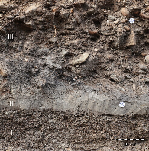
Unit I: Medium coarse sand with angular to sub-angular cobbles.
Unit II: Homogenous, gray, fine sand.
Unit III: Matrix of well-rounded, cobbles- to pebble-size gravel intermixed in coarse sand.
Unit IV: Cultivated soil.
Unit I is interpreted as early- to middle post-glacial sediment deposited primarily during the later part of the Early Mesolithic regression. The boundary between Units I and II is well-defined. The collection of unworked, sharp flint artifacts was detected in the uppermost parts of Unit I.
Unit II is an 8–15 cm thick, clean, homogeneous sand bed. The boundary between Units II and III is indistinct. There are two possible explanations for this unit. It could have been deposited during an initial stage of the Tapes transgression, resulting in fine sand washed inland, and then followed by coarser sediments in a cross-bed accumulation as the sea level rose in Unit III. Another explanation for a homogenous sandy layer could be deposits occurring after the Storegga landslide (8070–8180 cal BP), which created a tsunami with a run up of approximately 3–4 m in this part of western Norway (Bondevik et al. Citation1997). Both sediment morphology (i.e., the clean sand bed with a well-defined lower boundary), and the height correspond well with this event. However, as the Storegga tsunami occurred during the ongoing transgression, it is difficult to distinguish between a tsunami deposit and a storm event during the transgression (e.g., Bondevik, Svendsen, and Mangerud Citation1998). Nevertheless, the main problem in interpreting this as a Storegga tsunami deposit is the age, as the 14C (carbon) dates from underneath and above Unit II seem a few hundred years too young to be directly connected to this event. Additional research is needed to confirm or deny this event as a possible explanation for Unit II.
Unit III shows strong evidence of a beach ridge gradually built up by waves in a transgressive sequence. It consists of well-rounded cobbles and pebbles in a matrix of coarse sand and fine gravel and has a distinct low angle cross-bed composition where sediments are eroded in front of the ridge and deposited on the land side during build up (Otvos Citation2000). Throughout the middle Holocene, this process strongly affected prehistoric remains (i.e., lithics, dwelling remains, fireplaces, and charcoal), which were transported inland and incorporated in the beach matrix. Four superimposed fireplaces consisting of charcoal and fire-cracked stones were detected in the boundary between Unit II and III in the excavation field ().
Site chronology
Based on raw material, typology, vertical distribution, and stratigraphy, two distinct lithic chronological traditions were evident on the site. Phase 1 consisted of a total number of 334 artifacts, all of which were uncovered within 3 m2. The lithics were all flint and appeared stratigraphically in the boundary between Unit I and Unit II. Typologically, they consisted predominantly of flakes, but also 42 blades and 18 platform cores or fragments of platform cores (). The blades comprise mainly macro blades struck from a core with two opposite platforms and an acute platform angle. Despite some patination caused by exposure to the sun and saltwater, none of the lithic artifacts in this assemblage showed signs of being reworked by waves. Stratigraphically, these lithics were deposited prior to the formation of the beach ridge, indicating that they were protected by dense vegetation/peat cover. This is the most plausible explanation for how this intact assemblage managed to survive beneath the beach ridge without any evidence of wave reworking when the sea reached this level almost 3000 years after the flint was deposited. The small quantity of reworked greenstone (n = 16) collected in Phase 1 is evaluated as a contamination/redeposition during excavation.
Figure 10. Flint artifacts detected in the uppermost part of Unit I. (A) A core struck from two opposite platforms and an acute angle. (B) Blades and fragmented cores. (C) Flint flakes and waste material. None of these flint artifacts are reworked by waves.
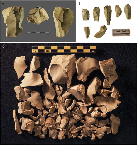
According to the masl measurement, this assemblage can be dated to 10,500–11,000 cal BP. This age is confirmed by a 14C dating of 10,300 cal BP collected from this stratum on Vika 3 (Beta 386061 (Cal BP 10,495–10,255), ref in Åstveit and Carrasco (Citation2016)). In my opinion, this stage represents a pre-greenstone phase and thus pre-dates the use of the Hespriholmen quarry. According to typological analysis, the lithic assemblage discovered in Phase 1 exhibits notable similarities with the archaeological classification known as the Fosna tradition or Fosna culture, which is assigned to the EM (Bjerck Citation2008).
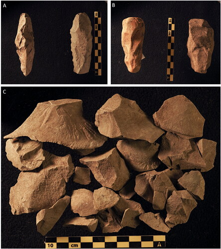
Phase 2 consisted of a total number of 18,365 artifacts, all of which were spread vertically through the beach ridge (Unit III). The majority was greenstone (n = 16,907) (), but 1062 flint artifacts were also revealed. This implies that flint was, to a certain degree, used together with greenstone in Phase 2. However, the flint artifacts differ substantially from the flint in Phase 1. This phase consisted of a more developed and diverse blade industry characterized by the removal of micro blades by pressure from a conical core with a platform angle close to 90 degrees and small blades struck from bipolar cores. Still, the most striking differences between the two phases are the large quantity of flakes (n = 16,819), slabs (n = 36), and preforms (n = 80) for adze production detected in Phase 2 ().
Figure 11. Greenstone artifacts collected in Unit III. (A) Adze preforms in category V0. (B) Adze preforms in category V1. (C) Waste material in category V0.
Quantity and distribution of wave-reworked lithics
Based on the information provided, it can be observed that there is a consistent increase in the overall quantity of lithics in all beach ridge layers from L18 to L3. However, there is a decrease in the number of lithics from L3 to L1. Furthermore, the analysis of lithics reworked by waves (V1) shows a distinct pattern across the sequence (). It appears that the deeper layers, from L15 to L5, contain a high proportion of lithic artifacts affected by wave reworking. On the other hand, L4 and L3 have a significant percentage of lithics that are not impacted by reworking (V0). It is worth noting that in L3, the number of lithics falling into the V0 category exceeds those in the reworked categories by about a 2:1 ratio. However, in L2, the number of V1 lithics once again surpasses the V0 category.
Figure 12. Distribution of greenstone excavated in 18 layers within two square meters in the beach ridge. Dashed line: reworked by waves V0, solid line not reworked by waves V1.

Discussion
What kind of site was Vika?
Phase 1: Initial occupation by foragers in the EM
The initial occupation at the site occurred during the later part of the early Holocene regression, which can be dated to approximately 10,500–11,000 cal BP according to the RSL data. This interpretation obviously rests upon the assumption that the site was located along the shore, and previous studies and extensive surveys have consistently shown a strong correlation between RSL and human presence during the Stone Age along the coastal regions of Norway (e.g., Åstveit Citation2009, Citation2018; Bjerck et al. Citation2008; Breivik Citation2014; Roalkvam Citation2023). This dating is also strongly supported by the lithic typology.
In Phase 1, Vika was utilized by small foraging groups probably residing on each location for a limited period of time. The flint scatter was found within an area of no more than 3 m2 and is the remains of one such small group passing through the vicinity. Small scatters of flint on elevated shorelines are a well-documented pattern in the EM (Åstveit Citation2009; Bang-Andersen Citation2012; Bjerck Citation2008; Fuglestvedt Citation2012; Nærøy Citation2000, Citation2018). Phase 1 also seems to fit recent theories of the EM in western Norway where the boat, transport, and safe landing spots are evaluated as essential for interpreting the distribution of EM sites along the coast (Bjerck Citation2013, Citation2017). The lack of greenstone in Phase 1 indicates that the quarrying of greenstone at Hespriholmen had not yet begun at this stage.
Phase 2: Greenstone workshop and mining activities in the Late Mesolithic
In Phase 2, it is obvious that a completely new form of activity takes place at Vika. Some 92% of the lithics consists of greenstone, and 99.6% of the greenstone is classified as debris, mostly flakes.
In comparison, the amount of debris would typically be around 75–85% at an average LM dwelling site while the rest would be classified as tools (Bjerck et al. Citation2008). Although the lithics from Vika vary in size and shape, most can be explained as waste material from the process of reducing blanks into adze preforms. When interpreting the lithic inventory, it is crucial to recognize both what is present as well as what is missing. Eighty preforms were found at the site, but of these, only five were complete (though damaged) adzes, a ratio that is also uncommon at an average LM site (i.e., Nærøy Citation1992). Tools belonging to the domestic sphere are more or less absent. These include grinding stones (n = 1), large grinding slabs (n = 0), scrapers (n = 6), and knives (n = 0). It is especially important to note the lack of grinding slabs, which are essential in the final stages of adze production as well as for sharpening the edges. These are regularly found at forager dwelling sites, and when these are missing, it seems likely that the adzes were neither completed at the site nor used in a way that involved the need for refinishing (see also Megarry et al. Citation2021). The low number of hammerstones (n = 3) is somewhat surprising, but can also be interpreted as an indication of this being a specialized workshop site, albeit for a specific part of the production process (i.e., the process between blanks/rough outs and preforms).
When reducing blanks into preforms, it is essential to remove as much as possible by knapping before the time-consuming grinding and polishing part of the production. To deliver precise blows, present-day knappers believe that indirect percussion, with antler or bone as a middle piece and a wooden mallet, was the most common method used (personal communication from professional flint knapper, Morten Kutschera; see also Stueber Citation2010). This technique leaves a limited number of hammerstones at the site and could very well be the reason why they are missing in the archaeological record in Phase 2.
This point is further supported by the fact that no less than 47 knapping-/hammerstones were detected in one 1 × 1 m trench at Hespriholmen, the largest of them 5 kg (Alsaker Citation1987). Several large knapping stones were also noted by divers on the seabed in front of the quarry (personal communication, diver/archaeologist, Jostein Gundersen). This is strong evidence that different stages in the production process are displayed in the lithics from Hespriholmen (rough-outs and blanks) and Vika (preforms), and that the completion of the adzes (picking, grinding, and polishing) primarily took place elsewhere, generally at the dwelling sites spread along the coast. However, thorough future investigations of the debitage found at different categories of sites would probably give valuable insight into the production process of the adzes. All in all, Phase 2 at Vika seems to fit Nyland’s (Citation2016, 23) definition of a workshop site: “A specialized site established for the sole purpose of the initial reduction of rock procured from a specific extraction site. At a workshop site, there is debitage from several stages of production, but not the finishing stages, including grinding.”
When attempting to estimate the total volume of greenstone, it is important to consider the difficulties in identifying greenstone that has been heavily reworked by water or waves. However, based on the weight of 192.4 kg of greenstone collected from the site, an average of 14.57 kg of greenstone per m3 can be determined. By combining the excavated volume of 13.2 m3 with an estimate of the non-excavated volume of 119 m3, a total of 1926 kg of greenstone is estimated to have accumulated on the site during the LM Period. Because a large percentage of the greenstone is so reworked by waves that it is morphologically unrecognizable, it is worth noting that this estimate may be conservative. Additionally, determining the ratio of waste to completed preforms is a challenging task. According to Alsaker (Citation1987), this proportion is estimated to be 1:4 (i.e., 1 kg of preforms resulted in 4 kg of waste material). Taking this into consideration, it is probable that at least 2000 kg of greenstone waste was deposited at the site during the LM Period, while around 500 kg of preforms were produced and shipped from the site. However, it is important to emphasize that this is a rough estimate.
When considering the quantity of reworked material in Phase 2, the high number of V0 lithics in L3 and L4 should be recognized as an in-situ deposition while most of the lithics in the deeper layers were probably deposited at lower levels and then washed inland by waves during the Tapes transgression (). The combination of reworked and non-reworked artifacts in the four uppermost layers is a strong indication that the beach ridge itself was used for occupation at this stage. However, a gradual and constant build-up would probably produce a larger amount of reworked material, so the uppermost layers indicate a build-up characterized by single events that superimposed the lithic material toward the end of the accumulation cycle of the ridge. As storm surges are most frequent during late autumn and winter, the activity and occupation at Vika likely took place during spring and summer. Possible occupation on an active beach ridge at this time of year has also been documented in other parts of western Norway during the Late Mesolithic (Bondevik et al. Citation2019). Finally, spring and summer would also be the right time of year to minimize the risk of traveling 5 km in the open sea to the quarry at Hespriholmen.
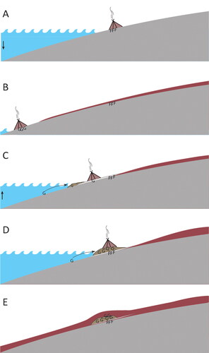
Figure 13. (A) Last part of early Holocene regression, 10,500–11,000 BP (Phase 1). Small groups of foragers. Flint artifacts (F) are deposited. (B) Early Holocene regression minimum, 9500–10,000 BP. Organic soil covers the flint artifacts. Most likely the first use of greenstone (G). (C) Mid-Holocene transgression approximately 8000 BP (beginning of Phase 2). People move to higher ground as the water level is rising. Greenstone is deposited and washed inland. The peat cover is eroded, and the sandy layer (Unit II) is deposited and eroded. (D) Transgression maximum, 7000 BP (Phase 2). Greenstone is still washed inland. Occupation takes place on top of the ridge. A matrix of reworked and not-reworked greenstone is accumulated in the uppermost layers of the ridge. The flint artifacts are well protected by the beach gravel (Unit III). (E) Present situation.
Frequency of trips from Vika to Hespriholmen based on estimated volume
The radiocarbon samples obtained from Phase 2 at Vika provide evidence of a primary occupation occurring between 7000 and 8000 cal BP. It is estimated that approximately 2500 kg of greenstone were deposited at the site during this period, resulting in an average annual collection rate of no more than 2.5 kg per year. However, it is highly unlikely that individuals would have undertaken a journey of 5 km through open seas annually to collect such a small amount of greenstone. While it is difficult to precisely determine the frequency of trips to Hespriholmen within a shorter time frame using the available data, the distribution pattern of lithics and the corresponding 14C ages at the site strongly suggest that journeys to Hespriholmen occurred regularly. Thus, it can be inferred that the trip to Hespriholmen held a significant level of importance for the greenstone collectors, with regularity being a defining characteristic of these expeditions.
It has been postulated that the trip from mainland Bømlo to Hespriholmen was extremely dangerous. Bergsvik (Citation2002, 13) states that: “Heavy winds and waves make Hespriholmen hard to access by small boats. Normally, safe journeys can only be arranged a few times during the summer months.” There is no doubt that going to Hespriholmen in an open boat involved a certain risk. However, stating that this journey was possible only a couple of times each summer seems like an overstatement. Although our fieldwork trips to Hespriholmen in an open boat were repeatedly delayed due to unfavorable weather conditions, Nyland (Citation2016) appears to be accurate in her critique of the term “extreme” to characterize the journey from the mainland to Hespriholmen. It is hard to acknowledge that the trip to Hespriholmen was attended with great risk by a marine hunter-gatherer-fisher population that had colonized and utilized the outermost part of the western coast at this time (Bergsvik et al. Citation2020; Bjerck Citation2008). It is further believed that the notion of the “dangerous journey postulate” has shaped the perception of greenstone as a valuable and therefore rare and exotic material during the Mesolithic. However, evidence from the Vika site, as well as the abundance of this raw material found at coastal sites and the significant number of large greenstone slabs left at the shoreline, indicates the possibility of an alternative interpretation. While the greenstone adzes may have been highly sought after and regarded as important items in short- and long-distance networks, it is plausible that the integrated value lay in the time and effort invested in the laborious knapping and grinding process, rather than the mere fact that the adzes were carved from the greenstone quarry at Hespriholmen specifically.
Abandonment of the site
The radiocarbon dates from Vika terminate around 7000 cal BP, but adzes produced in greenstone from Hespriholmen are found in high numbers on sites all through the LM as well as the early- and middle Neolithic. So, there is no doubt that the mining activity continued until at least 4500 cal BP. Consequently, it begs the question whether Vika was truly abandoned by 7000 cal BP, or if the dating sequence, erosion, or other factors may have caused an anomaly. During the middle Holocene regression, as sea level fell, it was common for both Mesolithic and later Neolithic people in western Norway to simply relocate along the regressive shoreline and carry on with their activities (i.e., Åstveit and Tøssebro Citation2023; Bjerck Citation2008). If preform-production was still taking place at Vika, we would probably have discovered evidence of this through the lithics recorded at the site. However, a thorough investigation into the lower levels of the site, Vika 2 (as shown in ), failed to uncover any traces of greenstone or indications of human occupation from the Mesolithic or the Early Neolithic periods. Based on the available information, it is highly probable that Vika was abandoned. Multiple factors could have contributed to this outcome. Two possible explanations that are not mutually exclusive are being considered here.
It is a well-supported theory that specialized workshop sites are a typical Mesolithic phenomenon, while in the Neolithic a larger part of the production among foragers took place at the residential sites. This change is believed to have had a profound impact on the way society was organized (Alsaker Citation1987; Bergsvik Citation2002; Nyland Citation2016). Although this interpretation is partly supported by this study, the main activity at Vika seems to have come to an end 1500 years before the transition to the Early Neolithic.
Furthermore, these findings appear to align with a comprehensive summed probability distribution (SPD) study of 702 14C samples collected from western Norway, specifically Hordaland, which indicates a notable decrease in the number of radiocarbon dates around 7000 cal BP (Bergsvik et al. Citation2021; see also Lundström Citation2023). This pattern was also observed in other regions further north of western Norway, approximately 350 km away, as reported by Bondevik et al. (Citation2019). The reasons underlying this decline in radiocarbon samples during this specific time period remain uncertain, and it is plausible that it is linked to a decrease in population size. Consequently, the results from Vika could potentially serve as an initial indication of a larger trend that future research may wish to reassess.
A local explanation for the abandonment of this site, however, is also possible (). As stated, transport and communication were probably of major importance in the late Mesolithic, not least at Vika as a specialized workshop and transfer site. In the earliest parts of Phase 2 (i.e., 8000 cal BP), the shoreline on the northeastern side of the site was approximately 1.2 km away from the site. The ground was, nevertheless, stable, and it was most likely no problem to transport heavy loads of greenstone from south to north. During the sea-level rise in the middle Holocene, the distance from south to north grew shorter, and at maximum transgression, it was possible to paddle almost all the way to the site from the north. However, during the regression after 7000 cal BP, communication became more difficult, and as the sea level fell, the transport route to the north was transformed into a long intertidal zone. Furthermore, the narrow valley with its steep sides was almost certainly filled with marine gyttja and mud. This situation probably made the site less favorable for transit and could well be the main reason why the site was abandoned. Different studies further indicate that the Sokkamyro/Langevåg area was used for producing greenstone adzes until the Middle Neolithic (Alsaker Citation1987), this was not the case at Vika.
Figure 14. A transect of The valley where the Vika site was situated. At 8000 BP the shoreline on the northeastern side of the site was approximately 1.5 km away from the site (arrow). During maximum transgression, it was, however, almost possible to reach the site by boat from the north. During the regression after 7000 BP, the narrow valley with its steep sides was probably filled up with marine gyttja and mud in a substantial intertidal zone. This situation could have made the site less favorable for transit and could well be the main reason why the site was abandoned at this point.
Conclusions
The floor at Hespriholmen quarry was submerged twice—prior to 10,700 cal BP, and between 8200 and 4000 cal BP. It is believed that mining began around 9000 cal BP during the time of minimum regression. As sea levels rose during the middle Holocene transgression (Tapes) between 9000 and 7000 cal BP, mining operations moved to higher elevations.
Excavations at Vika revealed evidence of two distinct occupation phases. Phase 1, estimated to be around 10,800 cal BP consisted of flint material associated with the Fosna tradition. These lithics were deposited under the tapes beach ridge and were not reworked by waves. Phase 2, dated to 8000–7000 cal BP and consisting mainly of greenstone, indicating that the site at this point had turned into a specialized workshop for transforming greenstone blanks into preforms for adzes. A significant percentage of the greenstone found in the lowermost layers showed signs of being reworked by waves. Notably, Phase 1 had no greenstone, indicating that mining operations at Hespriholmen had not yet begun at that time.
A rough estimation indicates that approximately 2.5 tons of greenstone were transported from Hespriholmen to the Vika site during the 1000-year-long Phase 2, highlighting significant mining and resource exploitation. The study shows the importance of using all material in the archaeological record even if this is reworked by waves and not in situ. It also emphasizes the importance for archaeologists to have consistent and reliable data on shoreline displacement, as determined by geologists through comprehensive investigations.
Acknowledgements
The research behind this article is primarily supported by my home institution, the University Museum of Bergen. I am deeply grateful to my colleagues Thomas Bruen Olsen for fruitful discussions during fieldwork at Hespriholmen and in Vika, and Hanne Årskog and Björn Nilsson for discussions and commenting on an earlier draft of the paper. Jostein Gundersen, Astrid Nyland, and Trond Meling volunteered at the end of the second season of the excavation. I also express my gratitude to reviewer 1, Professor Stein Bondevik, as well as an anonymous reviewer for their valuable insights and constructive criticism, which significantly contributed to enhancing the quality of the previous version of this manuscript. Additionally, I would like to acknowledge the invaluable contributions of Professor John Inge Svendsen in our discussions on sea-level fluctuations, sedimentation, and his assistance during the fieldwork conducted in Vika. It is always a great pleasure doing fieldwork with John Inge.
Disclosure statement
No potential conflict of interest was reported by the author(s).
References
- Alsaker, S. 1987. Bømlo—Steinalderens Råstoffsentrum på Sørvestlandet [Bømlo—A Stone Age Resource Center in Southwest Norway]. In Arkeologiske Avhandlinger [Archaeological theses from the University of Bergen] ed. A. Hagen, B. Solberg and I. Øye, vol. 4,11–114. Bergen: Historisk Museum, Universitetet i Bergen.
- Årrestad, K. K., and E. J. Warren. 2001. Kulturminner i Trekant-traséen. De arkeologiske undersøkelsene i forbindelse med utbygging av Trekantsambandet i kommunene Bømlo, Sveio og Stord i Sunnhordland [Cultural Heritages in the ‘Trekant Road Corridor’. The archaeological investigations related to the development of the Trekantsambandet project in the municipalities of Bømlo, Sveio, and Stord in Sunnhordland.]. In Arkeologiske Avhandlinger og Rapporter fra Universitetet i Bergen [Archaeological theses and reports from the University of Bergen], ed. G. Mandt and L. H. Dommasnes, 7–308. Bergen: Arkeologisk institutt, Universitetet i Bergen.
- Åstveit, L. I. 2009. Different ways of building, different ways of living: Mesolithic house structures in western Norway. In Mesolithic horizons, ed. S. Mccartan, R. Schulting, G. Warren, and P. Woodman, 576–87. Oxford: Oxbow Books.
- Åstveit, L. I. 2018. The Early Mesolithic of Western Norway. In Pioneering, resource use, coping with change, ed. H. P. Blankholm, 231–74. Sheffield: Equinox Publishing.
- Åstveit, L. I., and L. Carrasco. 2016. Arkeologiske undersøkelser ved Tjong-Løvegapet på Søre Bømlo [Archaeological investigations at Tjong-Løvegapet on Søre Bømlo]. In Arkeologiske Utgravningsrapporter fra Fornminneseksjonen. Avdeling for Kulturhistorie [Archaeological Excavation reports from section for Archaeological heritage management], ed, L. I. Åstveit, Bergen: University of Bergen.
- Åstveit, L. I., and C. Tøssebro. 2023. Sedentary people or short time events? High resolution radiocarbon chronology from a Late Mesolithic dwelling site in Western Norway. Journal of Archaeological Science: Reports 51 (51):104178. doi:10.1016/j.jasrep.2023.104178.
- Bang-Andersen, S. 2012. Colonizing contrasting landscapes. The pioneer coast settlement and inland utilization in southern Norway 10,000–9500 years before present. Oxford Journal of Archaeology 31 (2):103–20. doi:10.1111/j.1468-0092.2012.00381.x.
- Bergsvik, K. A. 2002. Task groups and social inequality in Early Neolithic Western Norway. Norwegian Archaeological Review 35 (1):1–28. doi:10.1080/002936502760123095.
- Bergsvik, K. A. 2006. Ethnic boundaries in Neolithic Norway. Oxford: BAR International series.
- Bergsvik, K. A., L. I. Åstveit, C. Zinsli, and T. B. Olsen. 2020. Faglig program i arkeologi for Universitetsmuseet i Bergen 2020–2025 . Steinalder til og med mellomneolittisk tid (9500–2350 f.Kr.). [Academic program in archeology for the University Museum in Bergen 2020–2025. From the Early Mesolithic to the Middle Neolithic (9500–2350 BC)]. Bergen: UBAS. Universitetet i Bergen
- Bergsvik, K. A., K. Darmark, K. L. Hjelle, J. Aksdal, and L. I. Åstveit. 2021. Demographic developments in Stone Age coastal western Norway by proxy of radiocarbon dates, stray finds and palynological data. Quaternary Science Reviews 259:106898. doi:10.1016/j.quascirev.2021.106898.
- Bergsvik, K. A., and A. B. Olsen. 2003. Traffic in stone adzes in Mesolithic western Norway. In Mesolithic on the move. Papers presented at the Sixth International Confernce on the Mesolithic in Europe, Stockholm 2000, ed. L. Larsson, H. Kindgren, K. Knutsson, D. Loeffler, and A. Åkerlund, 395–404. Oxford: Oxbow Books.
- Bjerck, H. B. 1982. Archaeological and radiocarbon dating of the Holocene transgression maximum (Tapes) on Skuløy, Sunnmøre, western Norway. Norsk Geologisk Tidsskrift 62:87–93.
- Bjerck, H. B. 1989. Mesolithic site types and settlement patterns at Vega, Northern Norway. Acta Archaeologica 60:1–32.
- Bjerck, H. B. 2008. Norwegian Mesolithic trends: A review. In Mesolithic Europe, ed. G. Bailey and P. Spikings, 107–31. Cambridge: Cambridge University Press.
- Bjerck, H. B. 2013. Looking with both eyes. Norwegian Archaeological Review 46 (1):83–7. doi:10.1080/00293652.2013.777101.
- Bjerck, H. B. 2017. Settlements and seafaring: Reflections on the integration of boats and settlements among marine foragers in early Mesolithic Norway and the Yámana of Tierra del Fuego. The Journal of Island and Coastal Archaeology 12 (2):276–99. doi:10.1080/15564894.2016.1190425.
- Bjerck, H. B., L. I. Åstveit, T. Meling, J. Gundersen, S. Normann, and G. Jørgensen. 2008. Ormen Lange Nyhamna: NTNU Vitenskapsmuseets arkeologiske undersøkelser [Ormen Lange Nyhamna: NTNU University Museum’s archaeological investigations]. NTNU (Norwegian University of Science and Technology). Trondheim: Tapir.
- Bondevik, S. 2003. Storegga tsunami sand in peat below the Tapes beach ridge at Harøy, western Norway, and its possible relation to an early Stone Age settlement. Boreas 32 (3):476–83. doi:10.1111/j.1502-3885.2003.tb01229.x.
- Bondevik, S., T. K. Lødøen, C. Tøssebro, H. Årskog, K. L. Hjelle, and I. K. Mehl. 2019. Between winter storm surges–human occupation on a growing mid-Holocene transgression maximum (Tapes) beach ridge at Longva, Western Norway. Quaternary Science Reviews 215:116–31. doi:10.1016/j.quascirev.2019.05.006.
- Bondevik, S., J. I. Svendsen, G. Johnsen, J. Mangerud, and P. E. Kaland. 1997. The Storegga tsunami along the Norwegian coast, its age and run up. Boreas 26 (1):29–53. doi:10.1111/j.1502-3885.1997.tb00649.x.
- Bondevik, S., J. I. Svendsen, and J. Mangerud. 1998. Distinction between the Storegga tsunami and the Holocene marine transgression in coastal basin deposits of western Norway. Journal of Quaternary Science 13 (6):529–37. doi:10.1002/(SICI)1099-1417(1998110)13:6<529::AID-JQS388>3.0.CO;2-1. doi:10.1002/(SICI)1099-1417(1998110)13:6<529::AID-JQS388>3.0.CO;2-1
- Breivik, H. M. 2014. Palaeo-oceanographic development and human adaptive strategies in the Pleistocene–Holocene transition: A study from the Norwegian coast. The Holocene 24 (11):1478–90. doi:10.1177/0959683614544061.
- Fægri, K. 1944. Studies on the pleistocene of western Norway. III Bømlo. Bergen: Bergens Museums Årbok 1943. Naturvitenskapelig rekke 8:1–100.
- Fuglestvedt, I. 2012. The pioneer condition on the Scandinavian Peninsula: The last frontier of a “Palaeolithic Way” in Europe. Norwegian Archaeological Review 45 (1):1–29. doi:10.1080/00293652.2012.669998.
- Hagen, A. 1983. Norges oldtid [Norwegian prehistory]. Oslo: J.W. Cappelens forlag.
- Hjelle, K. L., L. S. Halvorsen, L. Prøsch‐Danielsen, S. Sugita, A. Paus, P. E. Kaland, I. K. Mehl, A. Overland, R. Danielsen, H. I. Høeg, et al. 2018. Long‐term changes in regional vegetation cover along the west coast of southern Norway: The importance of human impact. Journal of Vegetation Science 29 (3):404–15. doi:10.1111/jvs.12626.
- Hughes, A. L. C., R. Gyllencreutz, Ø. S. Lohne, J. Mangerud, and J. I. Svendsen. 2016. The last Eurasian ice sheets—A chronological database and time-slice reconstruction, DATED-1. Boreas 45 (1):1–45. doi:10.1111/bor.12142.
- Kaland, P. E. 1984. Holocene shore displacement and shorelines in Hordaland, western Norway. Boreas 13 (2):203–42. doi:10.1111/j.1502-3885.1984.tb00070.x.
- Kolderup, N. H. 1925. Petrologische Untersuchungen tiber das Material für Steinzeitwerkzeuge im westlichen Norwegen [Petrological investigations into the material for Stone Age tools in western Norway]. Tschermaks mineralogische und petrographische Mitteilungen 38 (1):165–74. doi:10.1007/BF02993928
- Kristoffersen, S. 1995. Neolithic hunting stations on the Coast of Hordaland, Western Norway. Site organization, 151–73. Arkeologiske Skrifter, Bergen: Universitetet i Bergen.
- Lohne, Ø. S., S. Bondevik, J. Mangerud, and J. I. Svendsen. 2007. Sea-level fluctuations imply that the Younger Dryas ice-sheet expansion in western Norway commenced during the Allerød. Quaternary Science Reviews 26 (17–18):2128–51. doi:10.1016/j.quascirev.2007.04.008.
- Lundström, V. 2023. Living through changing climates: Temperature and seasonality correlate with population fluctuations among Holocene hunter-fisher-gatherers on the west coast of Norway. The Holocene 33 (11):1376–88. doi:10.1177/09596836231185839.
- Lundström, V., D. Simpson, and P. Yaworsky. Forthcoming. “Here by the sea and sand”: Uninterrupted hunter-fisher-gatherer coastal habitation despite considerable levels of population growth in neighbouring regions. Open Quartenary.
- Megarry, W. P., M. Markham, B. Gilhooly, B. O’Neill, and G. Cooney. 2021. Insular networks: An exploration of material distribution, insularity and island identity on the edge of Europe in the Shetland Neolithic. The Journal of Island and Coastal Archaeology 18 (4):612–34. doi:10.1080/15564894.2021.1880506.
- Melheim, A. L. 2015. Recycling ideas. Bronze Age metal production in southern Norway. BAR International Series. Oxford: BAR Publishing.
- Nærøy, A. J. 1992. Chronological and technological changes in western Norway 6000–3800 BP. Acta Archaeologica 62:77–95.
- Nærøy, A. J. 2000. Stone Age living spaces in western Norway. BAR International Series 857. Oxford: BAR Publishing.
- Nærøy, A. J. 2018. Early Mesolithic spatial conformity in southern Norway. Journal of Archaeological Science: Reports 18:905–12. doi:10.1016/j.jasrep.2017.10.021.
- Nyland, A. J. 2016. Humans in motion and places of essence. Variations in rock procurement practices in the Stone, Bronze and Early Iron Ages, in southern Norway. PhD diss., University of Oslo.
- Nyland, A. J. 2017. Quarrying in the Stone Age and Bronze Age in southern Norway studied as a socially situated phenomenon. Bulgarian eJournal of Archaeology 7 (1):133–54.
- Nyland, A. J. 2020. Nodal points in a Mesolithic mobile coastal world: Monumental quarries in south Norway. In Coastal landscapes of the Mesolithic, ed. A. Schülke, 341–58. London: Routledge.
- Olsen, A. B., and S. Alsaker. 1984. Greenstone and diabase utilization in the Stone Age of western Norway: Technological and socio‐cultural aspects of axe and adze production and distribution. Norwegian Archaeological Review 17 (2):71–103. doi:10.1080/00293652.1984.9965401.
- Otvos, E. G. 2000. Beach ridges—Definitions and significance. Geomorphology 32 (1–2):83–108. doi:10.1016/S0169-555X(99)00075-6.
- Prøsch-Danielsen, L. 2006. Sea level studies along the coast of southwestern Norway, with emphasis on three short-lived Holocene marine events. AmS-Skrifter 20: 7–94.
- Reimer, P. J., W. E. N. Austin, E. Bard, A. Bayliss, P. G. Blackwell, C. Bronk Ramsey, M. Butzin, H. Cheng, R. L. Edwards, M. Friedrich, et al. 2020. The IntCal20 Northern Hemisphere radiocarbon age calibration curve (0–55 cal kBP). Radiocarbon 62 (4):725–57. doi:10.1017/RDC.2020.41.
- Roalkvam, I. 2023. A simulation-based assessment of the relation between Stone Age sites and relative sea-level change along the Norwegian Skagerrak coast. Quaternary Science Reviews 299:107880. doi:10.1016/j.quascirev.2022.107880.
- Romundset, A. 2005. Strandforskyving og isavsmelting i midtre Hardanger [Coastal displacement and ablation in central Hardanger]. Master diss., University of Bergen.
- Schiffer, M. B. 1986. Radiocarbon dating and the “old wood” problem: The case of the Hohokam chronology. Journal of Archaeological Science 13 (1):13–30. doi:10.1016/0305-4403(86)90024-5.
- Shetelig, H. 1901. Et bosted fra stenalderen på Bømmeløen [A site from the Stone Age at the island Bømlo]. In Bergen Museums Aarbok, ed. J. Brunchorst, 2–21. Bergen: H. Grieg forlag.
- Shetelig, H. 1920. En landsænkning under yngre stenalder [An isostatic subsidence during the Neolithic], 28–41 Naturen. Bergen: Bergen Museum.
- Shetelig, H. 1922. Primitive Tider i Norge. En Oversigt over Stenalderen [Primitive times in Norway. An overview of the Stone Age]. Bergen, Norway: John Griegs Forlag.
- Simpson, D. 2009. Automating the extrapolation of sea-level displacement curves: Implications for Mesolithic research in Western Norway. In Mesolithic horizons. Papers presented at the Seventh International Conference on the Mesolithic in Europe, ed. S. McCartan, R. Schulting, G. Warren, and P. Woodman, 176–83. Belfast: Oxbow.
- Sørensen, M., T. Rankama, J. Kankaanpää, K. Knutsson, H. Knutsson, S. Melvold, B. V. Eriksen, and H. Glørstad. 2013. The first eastern migrations of people and knowledge into Scandinavia: Evidence from studies of Mesolithic Technology, 9th–8th Millennium BC. Norwegian Archaeological Review 46 (1):19–56. doi:10.1080/00293652.2013.770416.
- Stueber, D. O. 2010. The use of indirect percussion with stone punches for manufacturing rectangular cross section Type 1 adzes during the Moa–Hunter period of the Maori culture. In Experiments and interpretation of traditional technologies: Essays in honor of Errett Callahan, ed. H. G. Nami, 325–43. Buenos Aires: Ediciones de Arqueología Contemporánea.
- Svendsen, J. I., and J. Mangerud. 1987. Late Weichselian and Holocene sea-level history for a cross-section of western Norway. Journal of Quaternary Science 2 (2):113–32. doi:10.1002/jqs.3390020205.
- Vasskog, K. 2006. Holosen strandforskyvning på sørlige Bømlo [Holocene beach displacement on southern Bømlo]. Unpublished Masters thes., University of Bergen.