
 ?Mathematical formulae have been encoded as MathML and are displayed in this HTML version using MathJax in order to improve their display. Uncheck the box to turn MathJax off. This feature requires Javascript. Click on a formula to zoom.
Abstract
This study addresses the role of convective available potential energy (CAPE) in the intensification of simulated tropical cyclones. Additionally, it also examines the ‘wind-induced surface heat exchange’ (WISHE) theory in which CAPE is non-existent during intensification. We use a hierarchy of models with different complexity. A low-order tropical cyclone model forms the simplest model. It is found that the damping of CAPE by fast convective exchange as assumed in the WISHE theory inhibits substantial intensification in the model. This result can be explained by the dominance of the secondary circulation over surface heat transfer in the growth stage. It leads to entrainment of low entropy air into the eyewall resulting in the weakening of the cyclone. Other simulations reveal that the intensification rate increases with increasing initial CAPE and that the inner core CAPE is smaller than that of the ambient region. Investigations with the more complex Ooyama model yield qualitatively similar results. In this model, two types of convection are considered. The first one is based on frictional convergence in the boundary layer and the second one describes a convective adjustment including a precipitation efficiency. Only frictionally induced convection supports tropical cyclone intensification while the second one strongly acts to dampen the cyclone. Finally, the complex nonhydrostatic cloud model CM1 is used where the initial CAPE is varied. This model also exposes the existence of radially increasing CAPE during intensification. The experiments of this study indicate a positive relationship between the radial CAPE gradient and the intensification rate which disagrees with the basic assumption of WISHE models. The results emphasise the role of the secondary circulation for transporting high entropy air into the tropical cyclone inner core, and therefore should be considered in a proper intensification theory as has been done in the rotating convection paradigm by Montgomery and Smith.
1. Introduction
A complete and comprehensive theory on tropical cyclone intensification is still a work in progress. Many studies and extensive research have been dedicated to understanding the behaviour of tropical cyclones but in more recent times most of the focus is more on intensification (Montgomery and Smith, Citation2017). Several theories (see Montgomery and Smith, Citation2014) on intensification have been put forward where each has its own limitations. However, they do provide some insight into the tropical cyclone’s dynamics which has proven to be very useful in our understanding of intensification. Although there are many theories which address the problem from many different angles, there is still one question that has not gotten sufficient attention, and that is how does convective available potential energy (CAPE) fit into the theory of intensification. We still do not know the exact role CAPE plays while a storm is intensifying.
Ooyama (Citation1969) was one of the first to successfully simulate a tropical cyclone’s life cycle. He used a simple model which divided the atmosphere into only three layers: The thin planetary boundary layer (PBL), the middle troposphere and the upper troposphere. In this model, inflowing air in the frictional boundary layer converges and supplies the heat and moisture feeding the eyewall clouds which can only exist in the presence of local convective instability. Entrainment in the middle layer leads to an import of angular momentum and intensification. Charney and Eliassen (Citation1964) proposed before a linear theory where a tropical cyclone can develop and grow as a cooperative interaction with the cumulus convective activity and the cyclonic disturbance. The difference between the two as stated by Montgomery and Smith (Citation2014) lies in the way latent heat is treated. This cooperative interaction is called conditional instability of the second kind (CISK).
Later a new approach to cyclogenesis was proposed where Emanuel (Citation1986) and Rotunno and Emanuel (Citation1987) questioned the idea that a cyclone develops in a conditionally unstable environment. Emanuel further states that the storm is exclusively driven and maintained by surface fluxes of heat and moisture. This concept resulted in the so-called ‘Wind induced surface heat exchange’ (WISHE) theory for tropical cyclone intensification which does not rely on existing CAPE in the atmosphere. In the present study, we define WISHE as an intensification mechanism where convection acts so fast that CAPE vanishes and the temperature of the atmosphere is directly linked to the entropy of the boundary layer. Therefore, local warming of the atmosphere and associated cyclone intensification can only take place by wind-induced surface heat and moisture fluxes from the ocean surface which supports a feedback loop. In this way, the definition coincides with that given by Gray and Craig (Citation1998).
Later studies by Emanuel (Citation1997), Gray and Craig (Citation1998), Frisius (Citation2006) and Emanuel (Citation2012) demonstrated with highly simplified and idealised tropical cyclone models, that tropical cyclones can intensify without CAPE. Then, the acquired latent heat is immediately consumed by convection thus creating a moist neutral atmosphere. However, the models used in these studies contain many assumptions which could be misleading. Although it is true that surface fluxes form a necessary factor for intensification it is not clear whether it is the only factor. E.g. Schecter (Citation2011) found that CAPE increases prior to the rapid intensification phase in the Ooyama model and also in an idealised tropical cyclone simulation with the cloud-resolving model RAMS-6.0. Montgomery et al. (Citation2009) have argued that the WISHE approach to intensification is misleading. They put forth the vortical hot tower theory that indeed incorporates the existence of CAPE during tropical cyclone development. Their study was motivated by an earlier study by Van Sang et al. (Citation2008) in which they investigated the significance of surface fluxes of latent and sensible heat, and moisture. It was proven by simulations with the cloud-resolving model MM5 that even when the wind speed dependence of surface heat fluxes is capped there is little reduction in wind intensification. This result was already detected by Frisius (Citation2006) in a much simpler model based on the zero potential vorticity assumption. These are important findings since they challenge the essence of Emanuel’s air–sea interaction theory. Emanuel (Citation1986) and Rotunno and Emanuel (Citation1987) state that intensification is highly dependent on the rate at which water from the underlying ocean is evaporated, and this in turn is dependent on the speed of the inflowing air. Instead, the two companion papers by Van Sang et al. (Citation2008) and Montgomery et al. (Citation2009) along with Montgomery and Smith (Citation2014) and Montgomery et al. (Citation2015) support the rotating convective paradigm that describes the basic process of spin up to a mature hurricane vortex. This paradigm indicates that intensification is a result of the presence of hot plume vortical structures called vortical hot towers (VHTs) which were noted by Hendricks et al. (Citation2004) in a simulation of tropical cyclone formation. These deep rotating convective structures form in the inner core of the cyclone where they add to the large-scale circulation of the tropical cyclone (Montgomery and Smith, Citation2014). The formation mechanism depends like in the Ooyama model on the existence of local CAPE. The rotating convective paradigm also includes a description of intensification in the azimuthally averaged view. It includes two spin-up mechanisms, namely the tangential wind intensification by angular momentum import inside and above the boundary layer. The first mechanism involves gradient wind imbalance while the second one can be described in terms of the Sawyer-Eliassen equation based on the gradient wind balance. Frisius and Lee (Citation2016) found that both mechanisms can already be identified within the simple three-layer model by Ooyama (Citation1969).
Although Montgomery et al. (Citation2009) revealed the existence of CAPE during the complete intensification process in their presented simulations, its role is not entirely clear for the final spin-up phase in which the tropical cyclone attains hurricane strength and forms an eyewall. Certainly, CAPE is a necessary element for the initial phase where the VHTs spin-up and subsequently merge. However, it is not obvious how the VHTs could support the two axisymmetric spin-up mechanisms as presented by Montgomery and Smith (Citation2014). The heating by these VHTs would lead to a decrease of gradient wind and spin down if they would occur outside of the RMGW. Indeed, Frisius and Hasselbeck (Citation2009) found in a cloud resolving model that tropical cyclone intensification is most rapid if no convective activity appears outside of the developing core. Moreover, the absence of a wind-speed dependence of surface fluxes still leave room for intensification without CAPE as demonstrated in the model by Frisius (Citation2006). In the present study, we intend to shed light on these issues. If existence of CAPE turns out to be important, the intensification mechanism based on the models of Emanuel (Citation1997), Gray and Craig (Citation1998), Frisius (Citation2006) and Emanuel (Citation2012) would be questionable.
Persing and Montgomery (Citation2005) investigated the influence environmental CAPE would have on modelled hurricane intensity by making adjustments to environmental CAPE that did not affect the surface and outflow temperatures. By performing simulations with an axisymmetric model they came to the conclusion that any maximum potential intensity (MPI) theory that favours CAPE’s contribution should not be considered since they were not able to find justification for CAPE’s inclusion. This may not be quite the case for intensification. CAPE provides the energy that is available for convection and this affects the strength of the latent heat release which in turn affects the strength of the angular momentum import of the developing storm. The initial amount of CAPE can have an impact just as much as the CAPE that is being generated while the storm is intensifying.
In our paper, we investigate the role of CAPE for tropical cyclone intensification with a hierarchy of tropical cyclone models. This has the advantage that on one hand we can understand the mechanism in the simpler models while the results of the sophisticated models give us more confidence in the relevance of the mechanism. The comparison of the models must of course be sufficiently rigorous to avoid that similar results appear for different reasons. The outline of the paper is as follows. In Section 2, we present a conceptual model of intensification where we focus mainly on the aspects of intensification according to our interpretation of it. In Sections 3 and 4, the issue of CAPE is investigated with a simple low-order tropical cyclone model and a modified version of Ooyama’s three-layer model,Footnote1 respectively. Section 5 describes the complex cloud model CM1 and how numerical sensitivity experiments of tropical cyclone formation were configured. Section 6 presents the results of these experiments. The final Section 7 discusses the outcome of this study.
2. Conceptual Model of Intensification
We describe a conceptual model which highlights the key processes of intensification. The model corresponds to the azimuthally averaged view of the rotating convection paradigm by Montgomery and Smith (Citation2014) (see their Fig. 13d). Our focus is exclusively on the transitioning phase where the storm intensifies from a tropical storm to become a mature hurricane or typhoon. Figure shows the conceptual model for tropical cyclone intensification. In this model, there are five processes supporting the intensification process:
| (1) | Boundary layer inflow and spin up of ambient air mass; | ||||
| (2) | Evaporation over the sea; | ||||
| (3) | Rising of air in the eyewall; | ||||
| (4) | Latent heat release in the eyewall; | ||||
| (5) | Gradient wind adjustment to the modified temperature field. | ||||
Fig. 1. Conceptual model of intensification.
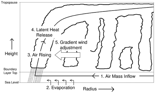
These five reinforce each other in the intensification process as suggested by the results of a previous study based on the Ooyama-model (Frisius and Lee, Citation2016).
This mechanism should hold regardless of if the cyclone is truly axisymmetric or not.Footnote2 As air flows into the cyclone over the warm ocean waters it carries high angular momentum inward although some amount is lost by surface drag. Through the process of evaporation it increases enthalpy and CAPE is generated.Footnote3 This high enthalpy is transported to the eyewall and overshoots the radius of maximum gradient wind (RMGW). Due to the deacceleration by the overshoot the air flows upward into the free troposphere where convection consumes the CAPE. The unbalanced boundary layer dynamics leading to the overshoot turns out to be important for generating an updraught inside of the RMGW (see Frisius and Lee, Citation2016). The convective activity releases enough latent heat to compensate adiabatic cooling because of the increase in boundary layer entropy with time and some existing CAPE. The negative radial gradient of warming at the outward side of the updraught induces a spin-up of the tangential wind by the gradient wind adjustment mechanism that can be well described by the Sawyer-Eliassen equation based on the balance approximation. Indeed, Shapiro and Willoughby (Citation1982) showed with this equation that heating inside of the wind maximum leads to inflow and angular momentum import. Furthermore, Frisius and Lee (Citation2016) found that in the Ooyama model the latent heat release is the most important process for the spin-up of the tangential wind above the boundary layer. The increase in gradient wind causes in turn a stronger boundary layer inflow, more angular momentum import and more evaporation from the sea surface. A positive feedback loop results.
As noted by Frisius and Schönemann (Citation2012) there can be a negative vertical entropy gradient in the boundary layer due to the fact that the boundary layer air experiences an increase of entropy due to surface fluxes. Such a negative entropy gradient creates a convectively unstable environment thus having CAPE. On the other hand, convection acts to reduce the thermodynamic disequilibrium that exists between the troposphere and the boundary layer. Therefore, surface fluxes of heat and moisture are necessary for maintaining the CAPE.
In the following, we explain the possible impact of CAPE on intensification. The tropical cyclone’s most intense winds are located beneath the eyewall. In the eyewall, air flows approximately along slantwise surfaces of constant angular momentum (Willoughby, Citation1988). This yields a flow that is neutral to symmetric instability if the up- and outward flow is fast enough to nearly conserve its specific entropy. We can take full advantage of this fact by replacing the radius r with a new radial coordinate, namely the potential radius R introduced by Schubert and Hack (Citation1983). It is given by
(1)
(1)
where v denotes the tangential wind, f the Coriolis parameter and M = vr + fr2/2 the angular momentum. Entropy surfaces run in the neutral case vertically in potential radius space and, therefore, entropy becomes a vertically independent variable. As noted by several authors such as La Seur and Hawkins (Citation1963), the circulation in a tropical cyclone is observed to be approximately in gradient wind balance. The saturation entropy gradient in the atmosphere is related to the gradient wind through the thermal wind balance equation (Emanuel, Citation1986). Using the thermal wind balance equation, Frisius and Schönemann (Citation2012) found in potential radius space the approximate relation:
(2)
(2)
where vb is the tangential wind at the top of the boundary layer, Ts the sea surface temperature, Tout the outflow temperature, sb the specific boundary layer entropy and ESC the slantwise CAPE (SCAPE). The first term on the right-hand side of Equation (Equation2(2)
(2) ) yields the thermal wind when the stratification is neutral to slantwise convection. This assumption has been used in the potential intensity theory by Emanuel (Citation1986) and in the simplified WISHE model by Emanuel (Citation1997). Obviously, further intensity can result when SCAPE increases in radial direction. Therefore, heating in the eyewall induces a larger intensity increase when SCAPE is present since the heating reduces SCAPE of the eyewall and increases the radial SCAPE gradient. This corresponds to a negative radial temperature gradient which is correlated with the wind intensity at the surface. Large initial SCAPE has a high potential to create a significant radial increase of SCAPE in the intensification phase but a requisite is that the release of SCAPE occurs predominantly in the inner core of the cyclone where the frictionally induced inflow converges. The effect of heating can be clearly seen in one of the model experiments performed by Montgomery et al. (Citation2009) (see their Fig. 5). In this run, the equivalent potential temperature above the boundary layer rises inside of the radius of maximum winds (RMW) while outside of this radius there is only a little increase. This results in a positive gradient of SCAPE and a tangential wind increase by the gradient wind adjustment. According to WISHE theory no SCAPE is present during intensification. Therefore, intensity builds entirely on the radial decrease of boundary layer entropy sb. However, there is no clear mechanism why it should do so. The surface enthalpy fluxes increase sb at the radius of maximum winds. Then, the radial gradient of sb becomes positive in the inner core of the cyclone so that Equation (Equation2
(2)
(2) ) does not yield a solution. Indeed, Fig. 5 of Montgomery et al. (Citation2009) reveals in the intensification phase no enhanced negative gradient of equivalent potential temperature in the boundary layer at the RMW which cannot be true if WISHE theory is correct. Furthermore, it can be shown that heating by wind speed dependent surface fluxes leads to outward migration of the tangential wind maximum (see Frisius, Citation2006). Emanuel (Citation1997), Gray and Craig (Citation1998) and Frisius (Citation2006) circumvented this issue by introducing a factor taking into account that convection at larger radii mainly acts to moisten and not to heat the atmosphere because of a dryer atmosphere. Montgomery et al. (Citation2009) doubted the physical justification of this factor and interpreted it as an ad hoc parameter. Later, Emanuel (Citation2012) modified his theory by taking into account that the outflow temperature Tout is not a constant but depends on the outflow stratification. With the assumption of a constant Richardson number in the outflow he was able to describe intensification by WISHE without a correction factor. However, Persing et al. (Citation2013) found on the basis of CM1 model simulations that the predictions of the revised theory do not hold. In our study, we suppose that vanishing CAPE (or SCAPE) is too strong a model constraint and that CAPE indeed represents an important key factor for tropical cyclone intensification.
3. Intensification in a low-order tropical cyclone model
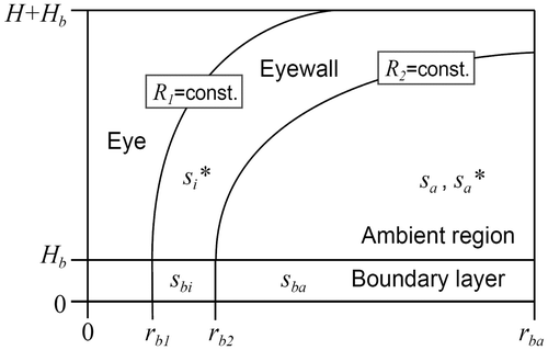
Schönemann and Frisius (Citation2012) developed a low-order tropical cyclone model that is sketched in Fig. . The model is divided into three regions: eye, eyewall and ambient region. Each region has a partition into the free atmosphere and boundary layer. The model variable is specific entropy s and gradient wind balance is assumed. Entropy is considered as an anomaly of a reference value of the far field boundary layer. The boundary layer entropy of the ambient region rises by surface fluxes and declines by vertical mixing due to convection. The entropy of the ambient region free atmosphere is assumed to be constant due to its large volume. The entropy of the boundary layer below the eyewall can also increase by surface fluxes. Here, however, the radial boundary layer mass flux is redirected in the vertical direction so that ascent and condensation takes place in the eyewall. In the eyewall, the atmosphere is assumed to be neutral to symmetric instability so that isentropes and angular momentum isolines are parallel. The boundaries of the eyewall form angular momentum surfaces where the potential radius R1 and R2 are constant in time. Consequently, the physical radii rb1 and rb2 enclosing the eyewall boundary layer move in the course of the development. The eye responds passively to the development of the eyewall. Therefore, no equations for the eye are needed in this model. It is assumed that above the boundary layer angular momentum conservation and gradient wind balance holds. Therefore, the eyewall boundary represents a material surface and its inward movement results from gradient wind adjustment. The moist potential vorticity vanishes because there is a congruence of angular momentum and moist entropy surfaces. This has the consequence that the tangential wind adapts to the predicted temperature field. The slab-boundary layer of the model has diagnostic balanced dynamics, i.e. the inflow velocity becomes a function of the gradient wind at the top of the boundary layer. The shortcomings of the balanced slab-boundary layer has been discussed by Smith and Montgomery (Citation2008) and Frisius and Lee (Citation2016) in the context of the Ooyama model. However, we believe that these shortcomings have not such a strong impact in the low-order model since it does not resolve the radial wind profile which sensitively influences the radial heating profile. Instead, it is assumed that all heating takes place in the eyewall region inside of the RMGW which corresponds to the result of unbalanced boundary layer dynamics. The governing equations of the low-order tropical cyclone model read
Fig. 2. Sketch of the low-order tropical cyclone model.
(3)
(3)
(4)
(4)
(5)
(5)
In these equations the indices b, i, and a refer to boundary layer, eyewall and ambient region, respectively. The asterisk * symbolises that the quantity is evaluated by assuming water vapour saturation, and (…) is the Heaviside step function. Furthermore, M denotes the mass of the corresponding region, Hb the boundary layer height, Ψb2 the radial boundary layer mass flux at radius rb2, CH the surface transfer coefficient for enthalpy, so the entropy at the sea surface, δ an entrainment parameter, τC the time scale of convection and τE the time scale of Newtonian cooling that represents a simple parameterisation of radiation in the model. vb1 and vb2 are the gradient winds at the inner and outer sides of the eyewall, respectively. The quantities vb1, vb2, Ψb2, Mbi, soi and soa are functions of the saturation entropy in the eyewall,
. For more details of the model we refer to Schönemann and Frisius (Citation2012). Schönemann and Frisius (Citation2012) showed that the intensification rate in the low-order model is proportional to
. This is qualitatively consistent with CM1 simulations performed by Persing et al. (Citation2013) (see their Fig. 21). Furthermore, the assumption that the RMW is connected with a constant angular momentum surface is roughly consistent with their model output (see their Fig. 23).
The model has been modified by adding convective exchange in the eyewall besides the vertical transport due to the frictional convergence in the boundary layer. Furthermore, the convective exchange in the ambient region only takes place in the unstable case, i.e. when sbi > . Then, we can test the WISHE theory for intensification. An element of this theory is that convection acts so fast that the atmosphere is always in a moist neutral state. Therefore, intensification should be possible for very small τC. Schönemann and Frisius (Citation2012) revealed indeed a WISHE instability in the linearised model. However, they did not consider this instability in the non-linear model. The model dynamics allow intensification by the WISHE mechanism in the extreme case τC → 0. Then, we have
= sbi and sba =
. In this case Equation (Equation5
(5)
(5) ) becomes unnecessary and Equation (Equation3
(3)
(3) ) can be combined with Equation (Equation4
(4)
(4) ) so that the indeterminate convective flux term is eliminated. This has the consequence that the low-order model reduces to one equation for eyewall entropy:
(6)
(6)
This equation can explain some intensification by WISHE at the beginning since the surface fluxes heat the eyewall immediately. It describes the adaption of the eyewall to sea surface entropy soi with the time scale
(7)
(7)
Later, however, the frictionally induced secondary circulation entrains low entropy air so that intensification is hampered. This process takes place with the time scale
(8)
(8)
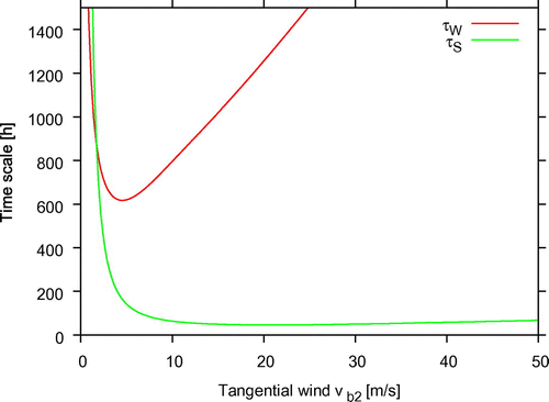
and it leads to transport of low entropy air of the environment () into the eyewall. Figure displays these time scales as a function of tangential wind vb2. Obviously, the WISHE time scale τW is only at low vortex intensity larger than that of the secondary circulation, τS. The time scale τS becomes much smaller than τW in the range where vb2 takes reasonable values for a typical intensification phase. From these circumstances we can conclude that the entropy fluxes of the secondary circulation dominate the budget of the eyewall entropy. This is in accordance with the study of Wang and Xu (Citation2010) who found in a cloud resolving model that inward boundary layer enthalpy transport is important to the energy balance in the eyewall of a mature tropical cyclone. The WISHE models by Emanuel (Citation1997), Gray and Craig (Citation1998), Frisius (Citation2006) and Emanuel (Citation2012) have no clearly defined boundary layers and do not include this process properly. Emanuel (Citation1997) introduced a parameter β to crudely account for downdrafts in the boundary layer. However, this parameter does not only reduce the boundary layer entropy, it also incorrectly reduces the radial advection that diminishes the eyewall entropy. Therefore, two competing effects are modified and it is not evident which one becomes dominant. Gray and Craig (Citation1998) and Frisius (Citation2006) introduced the β parameter in a different way by assuming that less latent heating occurs outside of the eyewall due to the dryer air. But in this approach no downdrafts into the boundary layer are considered. Without convective fluxes CAPE cannot remain zero and upward mass fluxes must be compensated by downward mass fluxes when the convergence of boundary layer winds is not dominant.
Fig. 3. Time scale of WISHE τW (red curve) and of the secondary circulation τS (green curve) as a function of tangential wind vb2.
To investigate the mechanism of intensification in this model we performed five numerical experiments. In these experiments, the relative humidity of the boundary layer and the free atmosphere are set to 80% and the sea surface temperature is set to 28 °C. These are conditions favourable for tropical cyclogenesis. For the time scale of convective exchange the value τC = 10 h is used unless otherwise stated. All other model parameters are listed in Table . The first experiment is the reference experiment REF in which and sbi have a finite value (0.6 J/kg/K) while sa and sba are set to zero. In this way a weak, initial vortex in a neutrally stratified undersaturated atmosphere is prescribed.
Table 1. Parameter values for the low order tropical cyclone model experiment REF.
In the second experiment, initial environmental CAPE is included (HIGHCAPE) by reducing the temperature of the ambient region, Ta by 2.5 K. In the third experiment (STABLE), the temperature Ta is increased by 2.5 K which stabilises the atmosphere. The fourth experiment WISHE integrates Equation (Equation6(6)
(6) ) so that the development of any CAPE is suppressed. The fifth experiment NOEXCHANGE includes an infinite time scale τC so that no convective exchange does take place in the ambient region.
Figure shows the time series of vb2 for the various experiments. All experiments start with a tangential wind vb2 of about 11 m/s. Experiment REF and HIGHCAPE reveal substantial intensification to a hurricane-type vortex within two days while in experiment WISHE only a marginal increase of wind speed takes place. Experiment STABLE exhibits a very fast decay of the vortex. The final tangential wind in experiment HIGHCAPE is with vb2 = 65 m/s much higher than in experiment REF where vb2 = 51 m/s is observed. Therefore, the steady-state tropical cyclone does indeed depend on environmental CAPE which disagrees with Persing and Montgomery (Citation2005). Furthermore, experiment HIGHCAPE exhibits a faster development compared to experiment REF. There is no gestation period in this model since it is assumed that the eyewall region is saturated outright at the beginning with the consequence that development starts immediately. We note that we can also destabilise and stabilise the atmosphere by modifying the boundary layer relative humidity. In this case the differences in the intensification phase are significantly smaller and the final intensities coincide (not shown). Therefore, the sensitivity of intensification to initial CAPE depends highly on how the CAPE is included. When CAPE is just included by modifying the boundary layer the effect turns out to be small since the boundary layer entropy can be modified very rapidly by surface fluxes and convective downdrafts. The situation is different when CAPE results by cooling of a deep free atmospheric layer. Then, the stratification can only be modified slowly by convection due to the high heat capacity of the layer. In the case of a deep stable layer the surface fluxes can hardly remove the stability. This is likely the reason why tropical cyclogenesis cannot occur below a certain threshold SST. Experiment NOEXCHANGE exhibits a development similar to HIGHCAPE. Obviously, the convective exchange due to a finite τC does have a damping effect on intensification and final intensity. The latter result was already found by Schönemann and Frisius (Citation2012).
Fig. 4. Tangential wind vb2 as a function of time for the experiments REF (red curve), HIGHCAPE (green curve), STABLE (blue curve), WISHE (magenta curve) and NOEXCHANGE (black curve).
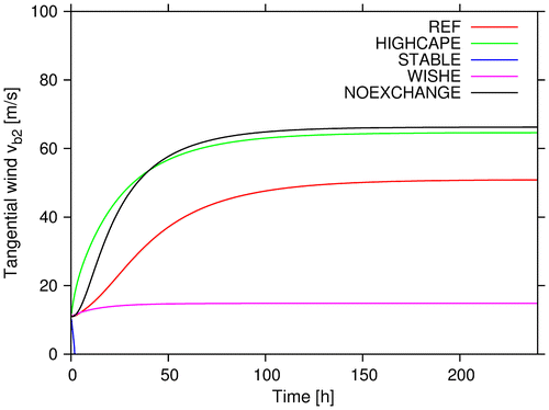
Experiment WISHE shows no intensification since the frictionally induced secondary circulation transports low entropy air into the eyewall. This is understandable since for an initial tangential wind of 11 m/s the time scale for the secondary circulation greatly falls below the WISHE time scale (see Fig. ). Therefore, the low-order model considered here does not allow intensification purely based on WISHE.
It appears that CAPE does play a role for intensification in the box model. We calculate the following expressions:(9)
(9)
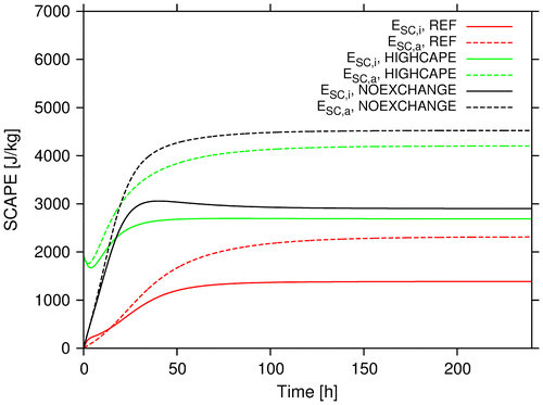
which can approximately be identified with SCAPE of the eyewall (ESC,i) and the ambient region (ESC,a), respectively (see Emanuel, Citation1994). Figure shows the development of ESC,i and ESC,a for the experiments REF, HIGHCAPE and NOEXCHANGE. All cases reveal an increase of SCAPE in the intensification phase. After intensification SCAPE attains a nonzero and constant level. Furthermore, we see that SCAPE of the ambient region exceeds that of the eyewall region increasingly during the intensification phase. This causes an enhancement of gradient wind and intensification rate due to the thermal wind balance equation (Equation2(2)
(2) ). Indeed, the other term in this equation, namely, the radial gradient of boundary layer entropy is rather weak since sbi exceeds sba only by a small amount. Therefore, an important key element of the WISHE and potential intensity theories building on vanishing CAPE is not fulfilled in the low order model. The substantial amount of eyewall SCAPE in the steady state turns out to be a somewhat unrealistic result that is related to the large mass of the eyewall region in the low order tropical cyclone model. From the results we can conclude that CAPE does play a crucial role for intensification in the simple low-order model. In the next section we check if this is true in the more complex Ooyama model.
Fig. 5. ESC,i (solid curves) and ESC,a (dashed curves) as a function of time for the experiments REF (red curves), HIGHCAPE (green curves) and NOEXCHANGE (black curves).
4. Intensification in Ooyama’s three-layer model
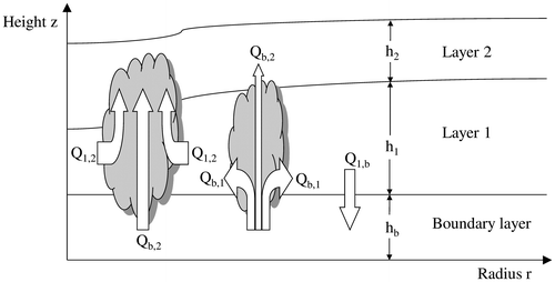
Figure sketches the Ooyama model that comprises three layers having the depths hb, h1 and h2. A free interface separates the middle and the upper layer while the interface between the boundary layer and middle layer is fixed but permeable. The densities of the two lower layers are identical while the upper layer has a density which is by a factor ε smaller. In the boundary layer micro-turbulent exchange and surface fluxes from the ocean surface become relevant. Convection can pervade all interfaces leading to mass fluxes Qb,1, Qb,2 and Q1,2. First, there can be a convective updraught from the boundary layer into the upper layer associated with the mass flux Qb,2. The flux Qb,1 describes detrainment of mass from this updraught in the middle-layer which is characteristic of shallow convection. Deep convection is on the other hand accompanied by an entrainment mass flux Q1,2 from the middle layer into the updraught. Mass conservation in the boundary layer requires the existence of a downdraught mass flux Q1,b from the middle layer into the boundary layer. Hydrostatic Boussinesq equations govern the flow in the model. The Ooyama model attracted wide attention in the scientific community (e.g. DeMaria and Schubert, Citation1984, DeMaria and Pickle, Citation1988, Smith, Citation1997, Dengler and Reeder, Citation1997, Camp and Montgomery, Citation2001, Schecter and Dunkerton, Citation2009, Frisius and Lee, Citation2016) and is considered as a simple model for explaining tropical cyclone intensification. A detailed description of the model was provided by Ooyama himself (Ooyama, Citation1969). The Ooyama model used here is an extended version in which unbalanced dynamics is included. The governing equations are listed in the Appendix A. A more detailed description of this model version was given in Frisius and Lee (Citation2016).
Fig. 6. Sketch of Ooyama’s three-layer model.
The Ooyama model has a simple parameterisation scheme for the mass fluxes between the various layers.Footnote4 It is assumed that the upward convective mass fluxes are proportional to the frictionally induced positive vertical velocity w at the top of the boundary layer so that
(10)
(10)
(11)
(11)
(12)
(12)
where Qb = 1/2(w + |w|) and η denotes the entrainment parameter given by
(13)
(13)
In this formula θe is the equivalent potential temperature (EPT) and the indices b, 1 and 2 refer to the boundary layer, middle layer and upper layer, respectively. Again, the asterisk * denotes a quantity evaluated under the conditions of water vapour saturation. A constant value is assumed for θe,1 while is proportional to the depth of the upper layer. A switch from shallow to deep convection takes place when the entrainment parameter η exceeds 1. Therefore η − 1 becomes a measure for deep convective instability. Without deep convective instability tropical cyclogenesis cannot take place since the necessary entrainment induced inflow in the middle layer is absent in this case. Therefore, we consider η − 1 as the relevant convective instability parameter. To compensate the boundary layer mass flux Qb a downward massflux
(14)
(14)
must occur due to mass conservation.
The Ooyama model only includes convective exchange triggered by frictional convergence in the boundary layer. Frisius and Lee (Citation2016) found with a stability analysis that for reasonable η values no convective instability can occur in the absence of surface friction. The original Ooyama model cannot describe intensification solely based on the WISHE mechanism since CAPE can build up in regions without frictional convergence. This corresponds to the situation when we set the convective time scale τC to infinity in the low-order model presented in the previous section. In the present paper, we wish to include also convection that does not depend on frictional convergence. Therefore, we have modified formulas for the mass fluxes in the case η > 1 as follows
(15)
(15)
(16)
(16)
(17)
(17)
(18)
(18)
where β = β(r,t) denotes the precipitation efficiency. It should account for the case when nonprecipitating convection just moistens the atmosphere without a net latent heat release. For β = 1 all condensated water will precipitate while for β = 0 no precipitation takes place. For intermediate cases we have 0 < β < 1. In the WISHE models by Emanuel (Citation1997), Gray and Craig (Citation1998) and Frisius (Citation2006) a radially decreasing β was necessary to obtain intensification. Note that this effect is also implicit in the above treated low-order model since in the ambient region convection does not lead to latent heating while in the eyewall region all condensated water precipitates. Although β might be an ad hoc parameter as mentioned by Montgomery et al. (Citation2009), it will be used in this model to reveal if intensification with nonexistent CAPE can only take place by prescribing such a parameter. The precipitation efficiency is considered as a fluid property of the middle layer. Therefore, it is governed by the equation(19)
(19)
where u1 denotes the radial wind of the middle layer and the condition β = 0 has been applied at the lateral boundary. The surface fluxes were calculated with a bulk scheme as in the low order tropical cyclone model. The surface transfer coefficients for momentum and enthalpy coincides and result from the parameterisation CD = CH = 0.0005(1 + Vb/8.33) where Vb denotes the wind speed in the boundary layer. In the Ooyama model we use a simple expression for CAPE, namely:(20)
(20)
where cp denotes the specific heat at constant pressure and α = 10 a thermodynamic constant introduced by Ooyama (Citation1969). The energy EC,O must be positive for the appearance of deep convection.
A relationship similar to Equation (Equation2(2)
(2) ) can be derived within the Ooyama model. Ooyama (Citation1969) assumes upright convection and, therefore, it is more appropriate to evaluate the thermal wind balance equation in physical space. This equation becomes at a small radius where we can assume cyclostrophic balance:
(21)
(21)
Here, v1 and v2 denote middle- and upper-layer tangential winds, respectively. The expression on the left-hand side of this equation measures the intensity of the thermal wind and it is likely related to the maximum wind speed of the vortex. Similar to Equation (Equation2(2)
(2) ), further intensity may arise when CAPE increases in radial direction.
For the numerical experiments we use this simple axisymmetric three-layer model in an unbalanced configuration as described in Frisius and Lee (Citation2016). The numerical model employs 2400 stretched radial grid points having a distance of 250 m and 2500 m in the inner and outer parts of the domain, respectively. Horizontal diffusion is necessary to avoid the build-up of sharp gradients. The model adopts a diffusion coefficient of νh = 1000 m2/s. More information on the numerical method and model parameters are given in Frisius and Lee (Citation2016). The reference experiment REF_OOYAMA is identical to experiment UNBAL in Frisius and Lee (Citation2016) except for the initialisation of boundary layer EPT, θe,b which is set identical to in order to have zero CAPE initially. The initial vortex has a balanced tangential wind profile of the form
(22)
(22)
where Vmax,0 = 10 m/s is the maximum tangential wind and r0 = 50 km the radius where the maximum occurs. No flow is initially present in the upper layer. Table lists the model parameters used for this experiment. Convection is only triggered in REF_OOYAMA by frictional convergence which corresponds to τC → ∞. Furthermore, the β parameter is set to one so that the effect of a radially decreasing precipitation efficiency is ignored. Experiment REF is identical to REF–OOYAMA except for switching on the additional convective exchange with a time scale of τC = 24 h. The experiments HIGHCAPE and STABLE conform to REF but they include different initial stratifications. In HIGHCAPE the initial EPTs θe,1 and are decreased by 5 and 10 K, respectively while in STABLE these temperatures are raised by the same amounts. Experiment WISHE adopts the additional convective scheme with a time scale of τC = 1 min. Then, the time scale is so short that CAPE vanishes approximately during the complete simulation. Experiment WISHE_DRY includes a radially decreasing precipitation efficiency. At the beginning it has the following profile:
Table 2. Parameter values for Ooyama model experiment REF.
(23)
(23)
This profile yields a dry region beyond the radius r0 where the tangential wind is maximised initially. Then, the conditions for intensification according to the aforementioned WISHE models are fulfilled since the precipitation efficiency decreases radially at the radius of maximum winds.
Figure shows time series of maximum tangential wind of the middle layer and the radius where this maximum occurs. The time developments of maximum tangential wind agree in many qualitative aspects with those obtained with the low-order model (cf. Fig. ). However, we can also see some qualitative differences. Experiments REF and HIGHCAPE do not approach a steady state and reveal instead a slow decay of intensity after the tangential wind has maximised. A very slow development occurs in experiment STABLE instead of a rapid decay as observed in the low-order model. The experiment WISHE also does not reveal significant intensification. The introduction of a radially decreasing precipitation efficiency in experiment WISHE_DRY even causes a slow decay of intensity. The experiment REF_OOYAMA reaches the highest intensification rate and it exhibits a very slow decay in the later stages. Therefore, convection solely based on frictional convergence leads to the most rapid intensification and a better maintenance of the storm. This experiment corresponds to experiment NOEXCHANGE in the low-order model in which we found equivalent results. The radius of maximum winds (RMW) decreases during the intensification phase in experiments REF, HIGHCAPE and REF_OOYAMA. After intensification a slow increase of RMW is observed. In experiment STABLE the RMW becomes larger during the first six days and then declines slowly. The continuous outward migration of RMW in experiment WISHE is consistent with the findings of Frisius (Citation2006) where it was shown that the WISHE mechanism causes this migration in the absence of an outward decreasing precipitation efficiency. Experiment WISHE_DRY exhibits some RMW contraction during the first 4 days but the RMW migrates outwards thereafter despite the radially decreasing precipitation efficiency.
Fig. 7. (a) Maximum middle layer tangential wind as a function of time for the experiments REF (red curve), REF_OOYAMA (black curve), HIGHCAPE (green curve), STABLE (blue curve), WISHE (magenta curve) and WISHE _DRY (light blue curve). (b) as in (a) but the radius of maximum v1 is shown.
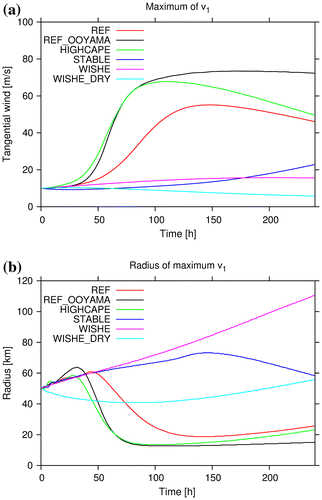
The results clearly show that the WISHE mechanism cannot cause intensification within the Ooyama model. Relaxing CAPE to neutrality by the convection parameterisation reduces the intensification rate substantially and allowing only little CAPE by using a short time scale for convective exchange (about 1 min) does not lead to a mentionable increase of wind speed. Therefore, a significant amount of CAPE is necessary for intensification to take place in the Ooyama model. We can draw the conclusion that either the Ooyama model or the WISHE models does not explain tropical cyclone intensification properly. In the WISHE models the neglect of entrainment of low entropy air into the boundary layer could be a serious deficiency. On the other hand, the assumption of a time invariant middle layer entropy in Ooyama’s model could also be unsuitable.
The additional convective scheme used in the present model has some similarity with the quasi-equilibrium scheme included by Zehnder (Citation2001) and Schecter (Citation2011) in an Ooyama-like model. However, the convective mass fluxes of their scheme relate to the disequilibrium between the boundary layer and middle layer. Then, decreasing the time scale would lead to a moist stable and not moist neutral state as in the WISHE model. Schecter (Citation2011) found a decrease of intensification rate by the inclusion of this scheme besides the primary convergence based scheme. Zhu et al. (Citation2001) used in a three layer tropical cyclone model a similar scheme where the convective mass fluxes are proportional to CAPE (their modified Arakawa scheme). They also detect a substantially weaker tropical cyclone intensification compared to a run based solely on a convergence based convection parameterisation.
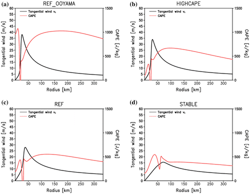
Figure shows various experiments’ radial profiles of tangential wind v1 and CAPE EC,O at the time when the profile maximum of tangential wind v1 exceeds 50% of the time maximum of v1. All simulations reveal nonzero CAPE at nearly all radii. Narrow radial ranges with zero CAPE only occur inside the RMW in all shown experiments except for STABLE. These are located inside of the eyewall where a downdraught transports low entropy air into the boundary layer. It is noticeable that CAPE in experiment REF_OOYAMA has the largest values inside of the eyewall while in the other experiments this is not the case. This happens because CAPE accumulate in the inner core when frictional convergence does not occur in the absence of additional convective exchange. CAPE increases with radius immediately outside the RMW in all experiments except for STABLE. The associated radial CAPE gradient seems to correlate with the intensification rate. This result suggests a positive impact of a radially increasing CAPE on intensification within the Ooyama-model which is in agreement with the thermal wind balance equation.
Fig. 8. Radial profiles of tangential wind v1 (black curve) and CAPE EC,O (red curve) in the Ooyama-model at the time when the intensity reaches 50% of its time maximum for the experiments (a) REF_OOYAMA, (b) HIGHCAPE, (c) REF and (d) STABLE.
5. Description of CM1 and experimental configuration
We conduct further experiments with the nonhydrostatic cloud resolving model CM1, version 18. The model was developed by George Bryan at NCAR (Bryan and Fritsch, Citation2002; Bryan and Rotunno, Citation2009) and it can conduct simulations in axisymmetric, 2D and 3D configurations. In our experiments we use the 3D configuration. The model solves non-linear time dependent governing equations having eleven prognostic variables: The three components of velocity (u,v,w), the perturbation Exner function (non-dimensional pressure) (π′), perturbation potential temperature (θ′), and the mixing ratios for water vapour (qv), cloud water (qc), rain (qr), cloud ice (qi), snow (qs) and graupel (qg).Footnote5 An f-plane is assumed, and the Coriolis parameter is set to 5 × 10⁻⁵ s−1. The boundary conditions are periodic in all directions and at the surface we assume an ocean having a fixed sea surface temperature of 28 °C. For a more detailed description of CM1 see Bryan and Fritsch (Citation2002) and Bryan and Rotunno (Citation2009).
We use the default configured namelist for tropical cyclone simulation except for some changes as described below.Footnote6 We switched off the radiation scheme of CM1 for all experiments and mimicked this process by a simple relaxation method as described by Rotunno and Emanuel (Citation1987). For cloud microphysics the double-moment scheme by Morrison et al. (Citation2005) excluding hail is applied. The micro-turbulent exchange and dissipative heating is parameterized by a Smagorinsky-type scheme with different coefficients for vertical and horizontal exchange. The surface exchange scheme employs a constant transfer coefficient of CH = 0.0012 for heat and moisture while the surface drag coefficient CD results from a parameterisation that is based on findings of Fairall et al. (Citation2003) at low wind speeds and of Donelan et al. (Citation2004) at high wind speeds. By this parameterisation the surface drag coefficient becomes
(24)
(24)
where V10 m denotes the horizontal wind speed at 10 m height, V0 = 5 m/s and V1 = 25 m/s. The grid spacing is set to 2 km with 600 grid points in each horizontal direction and 40 model levels in the vertical having a 500 m grid spacing are adopted. The model is time-integrated by adopting the Klemp-Wilhelmson time-splitting, vertically implicit scheme with a large time step of 7s and 4 intermediate short time steps. To test the sensitivity of the tropical cyclones intensification to CAPE we need to analyse its radial distribution at the time of maximum intensification. First we define CAPE as:
(25)
(25)
where ZLFC is the level of free convection in the boundary layer, ZLNB the level of neutral buoyancy, g the acceleration due to gravity, Tv,p the virtual temperature parcel of the moist adiabat and Tv,e the virtual environmental temperature. For the calculation we used an open source FORTRAN code.Footnote7 We did an azimuthal averaging with respect to the surface pressure minimum to get the radial distribution.
Three experiments are conducted for different vertical temperature profiles. The moist tropical (MT) sounding found by Dunion (Citation2011) is adopted to provide the base state conditions for the reference experiment REF. In the other two experiments the Dunion sounding was cooled or warmed by adding a horizontally uniform temperature anomaly of the form(26)
(26)
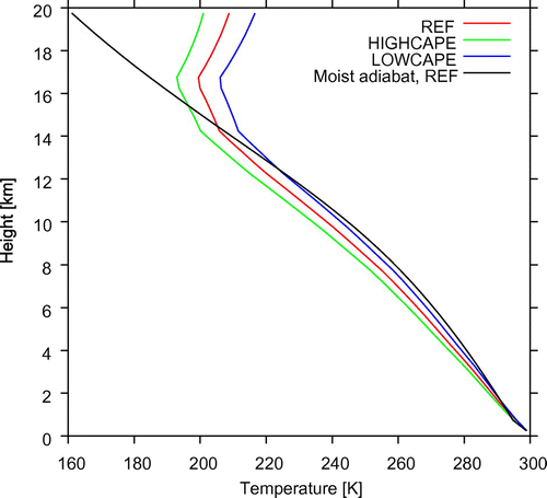
where z denotes the height and ∆Tt the temperature anomaly at a height of 10,000 m. Note that T′ increases or decreases further for larger heights. In experiment HIGHCAPE the atmosphere is cooled by setting the temperature profile parameter to ∆Tt = −5 K. Experiment LOWCAPE starts on the other hand with a warmer atmosphere where ∆Tt = 5 K. The three experiments LOWCAPE, REF and HIGHCAPE have different initial CAPE values, namely 28.8 J/kg, 952 J/kg and 2435 J/kg, respectively. Therefore, we can assume that the initial atmosphere in LOWCAPE is nearly neutrally stratified. Dunion (Citation2011) found a much higher CAPE value (1922 J/kg) for his sounding which presumably results from the neglection of condensate loading and virtual temperature effects. We also calculated CAPE by assuming a pseudoadiabatic ascent where all condensate precipitates immediately. Then, the CAPE value is with 2519 J/kg/K much closer to the result of Dunion (Citation2011).
Figure shows the initial vertical temperature profiles of the three experiments together with the moist adiabat resulting from the initial condition of experiment REF. All temperature profiles have an inversion at about 17 km height but an already very stable layer occurs above 14 km so that the level of neutral buoyancy is well below 17 km in all three cases. Since the moist adiabat is largely independent of the added temperature anomaly T′ it is obvious from the various profiles that CAPE decreases with increasing ∆Tt. The initial vortex is identical to that used by Rotunno and Emanuel (Citation1987) in their axisymmetric model as given by their Equation (37). It has a maximum tangential wind of about 12 m/s at a radius of 100 km. The outer radius beyond which the tangential wind vanishes is 412.5 km. The tangential wind decreases linearly with height until the lower bound of the sponge layer at 20 km height where winds become zero.
Fig. 9. Initial vertical temperature profiles for the CM1 experiments REF (red curve), HIGHCAPE (green curve) and LOWCAPE (blue curve). The black curve shows the moist adiabat resulting from the initial condition of experiment REF.
6. Results of the CM1 experiments
Figure shows the time evolution of maximum horizontal wind speed for the three CM1 experiments. Obviously, environmental CAPE accelerates the tropical cyclone intensification in CM1. In experiment LOWCAPE a very slow intensification rate arises so that the tropical cyclone does not reach hurricane strength (33 m/s) before 4.5 days (108 h). On the other hand, a category 5 hurricane (69 m/s) according to the Saffir Simpson scale evolves within 75 h in experiment HIGHCAPE. The evolution in experiment REF lies in between. However, we see that the actual rates of intensification in HIGHCAPE and REF are quite similar. Therefore, the evolution in HIGHCAPE takes place earlier but not really faster in comparison to experiment REF. The latter result was not found in the low-order model (see Fig. ) and also not in the Ooyama model (see Fig. a). The final intensities of REF and HIGHCAPE are quite similar. This agrees with the finding of Persing and Montgomery (Citation2005) that the environmental CAPE has no influence on final intensity. We do not know how much the intensity rises further in experiment LOWCAPE but it is obvious that the tropical cyclone intensifies slower in comparison to REF and HIGHCAPE in contradiction to Persing and Montgomery (Citation2005). The different method for determination of the initial sounding could explain this result. Persing and Montgomery (Citation2005) found the sounding of their ‘low CAPE run’ by running the model without vortex until a neutral state arises as was also done by Rotunno and Emanuel (Citation1987). This leads to a different temperature and moisture profile. However, in the present LOWCAPE experiment only the temperature sounding is modified with the consequence that the relative humidity attains in the mid-troposphere a smaller value compared to REF and HIGHCAPE. It is conceivable that the lower initial relative humidity mainly explains the slower development in CM1. Furthermore, the differences between the model physics of CM1 and that of the axisymmetric model used by Persing and Montgomery (Citation2005) could also explain the contradiction. In the latter model, ice was absent in the cloud microphysical scheme and it is known that tropical cyclones intensify faster without ice (see, e.g. Frisius and Hasselbeck, Citation2009).
Fig. 10. Maximum azimuthally averaged wind speed as a function of time for CM1 experiments REF (red curve), HIGHCAPE (green curve) and LOWCAPE (blue curve). The black circles indicate time points representative for the intensification phase. These were selected for the further analysis.
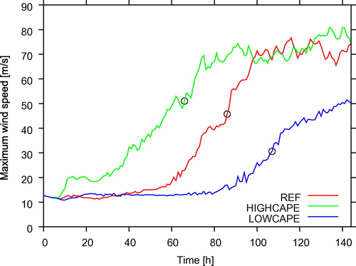
Figure displays snapshots of CAPE and surface pressure for the three CM1 experiments at selected time points during intensification (marked by black circles in Fig. ). In all three cases the tropical cyclone core is clearly visible in the surface pressure field. There, zero or very low CAPE values arise, but with increasing radius the CAPE becomes larger and beyond a certain radius it decreases again. In LOWCAPE the CAPE field is very asymmetric while in REF and HIGHCAPE a closed ring with positive CAPE can be detected. However, HIGHCAPE also shows a prominent wavenumber 2 asymmetry in CAPE at larger radii. Figure shows radial profiles of azimuthally averaged CAPE together with tangential wind at the level of maximum wind speed for the three experiments at the same selected time points. We see that a positive radial CAPE gradient occurs immediately outside the radius of maximum tangential wind in all three cases.Footnote8 In experiment LOWCAPE, the CAPE gradient is very weak while in REF and HIGHCAPE the CAPE profiles have similar slopes between the radii 20 and 70 km. This could possibly explain the similar intensification rates of these two experiments. In any case, the CM1 simulations also show that CAPE exists during intensification and that it increases radially outside of the RMW. This is consistent with observational studies by Frank (Citation1977), Bogner et al. (Citation2000) and Molinari et al. (Citation2012) in which the authors found that CAPE decreases toward the cyclones centre. We also performed corresponding simulations with the axisymmetric CM1 model. The results agree qualitatively with the 3D simulations. However, the cyclone grows faster and reaches a higher intensity in the axisymmetric set-up, and the CAPE fields are noisier in space and time. The differences are consistent with the findings of Persing et al. (Citation2013).
Fig. 11. CAPE (coloured shadings) and surface pressure (isolines) for (a) experiment LOWCAPE at t = 107 h (contour interval 2.5 hPa), (b) experiment REF at t = 87 h (contour interval 5 hPa) and (c) experiment HIGHCAPE at t = 66 h (contour interval 5 hPa).
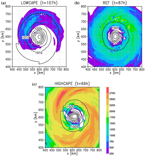
Fig. 12. Radial profiles of azimuthally averaged tangential wind (black curve) at the level of maximum wind speed (z = 750 m) and CAPE (green curve) for (a) experiment LOWCAPE at t = 107 h, (b) experiment REF at t = 87 h and (c) experiment HIGHCAPE at t = 66 h.
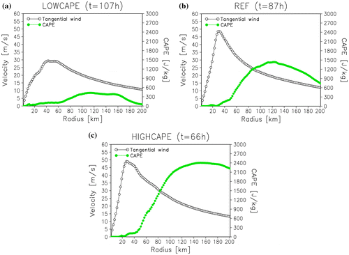
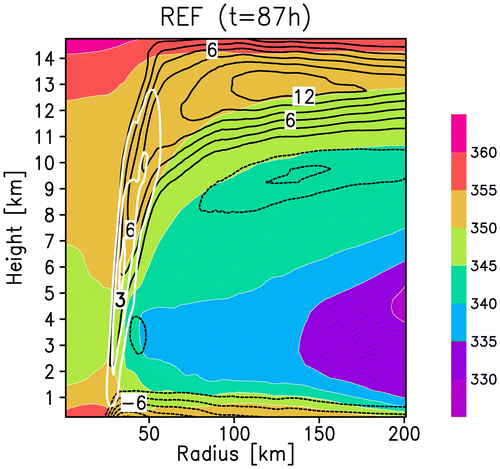
Figure displays the azimuthally averaged EPT, radial wind and vertical wind for experiment REF at the selected time point. This graph reveals the thermal structure and the secondary circulation in the inner core of the intensifying tropical cyclone. The fields agree with the conceptual model sketched in Fig. as high entropy air in the boundary layer flows inward to the eyewall where the vertical motion turns into a slantwise outflow with a negative radial gradient of θe. Very low EPTs occur in the lower part of the troposphere immediately above the boundary layer. Fast convective exchange like in the WISHE models would likely decrease the boundary layer entropy in such a way that the eyewall would soon dissolve leading to a cyclone decay. The figure also shows a weak radial gradient of boundary layer entropy under and outside of the eyewall which accords with the low order tropical cyclone model but disagrees with the WISHE theory that must build on a substantial negative gradient of this quantity.
Fig. 13. Radial cross section of azimuthally averaged EPT (coloured shadings, K), radial wind (black isolines, contour interval 2 m/s) and vertical wind (thick white isolines, contour interval 1 m/s) for CM1 experiment REF at t = 87 h.
7. Conclusion
In this study, we investigated the role of CAPE for tropical cyclone intensification by using a hierarchy of models having different complexity. With the conceptual model we explained the possible mechanism of intensification enhancement due to CAPE. It is assumed that generated CAPE by surface fluxes does not decay immediately by convection. Then, a substantial amount of high entropy air reaches the eyewall where it releases the latent heat. There are two aspects for enhanced intensification. First the higher amount of latent heat increases the negative radial temperature gradient. Second, the absence of convection outside the eyewall avoids a decrease of the negative radial temperature gradient. Both effects causes an increase of gradient wind which accelerates the intensification due to a stronger frictional inflow and higher surface heat fluxes. The WISHE theory excludes this mechanism since it is assumed that convection removes CAPE immediately. We challenged this assumption by testing it in two tropical cyclone models. The first one is a simple low-order model in which the vortex is divided into five regions. We showed that in this model the tropical cyclone cannot attain hurricane strength by assuming immediate convection although the WISHE mechanism works for small amplitude vortices. The reason for the absence of substantial intensification is that low entropy air of the ambient region gets into the eyewall by the frictionally induced secondary circulation. This mechanism forms an effective brake for intensification in the low-order model when CAPE is not present. On the other hand, it was found that the tropical cyclone intensifies significantly when CAPE can be generated by surface fluxes. Then, the frictionally induced secondary circulation supports intensification because it transports high entropy air from larger radii into the eyewall which is consistent with findings by Wang and Xu (Citation2010) within a complex tropical cyclone model. Environmental CAPE supports intensification while a stable atmosphere causes a decay of the initial perturbation in the low-order model. Qualitatively similar results were obtained with Ooyama’s three layer model. This model also does not support intensification without allowing CAPE to develop. Even the inclusion of a radially decreasing precipitation efficiency as introduced by Emanuel (Citation1997) does not suffice to initiate a WISHE feedback. This is in agreement with Montgomery et al. (Citation2009) and Montgomery et al. (Citation2015) who disproved the necessity of a WISHE feedback for intensification and found nontrivial CAPE in their simulated tropical cyclone developments. On the other hand, it was found that Ooyama’s convection parameterisation scheme solely based on frictional convergence yields the fastest intensification and a higher persistence of the mature vortex. Additional convective exchange causes a decrease of CAPE and this lessens the intensification rates. In the Ooyama model, the radial gradient of CAPE outside of the eyewall seems to be correlated with the intensification rate. This result is in agreement with the conceptual model. The simulations with the cloud resolving model CM1 also reveal an impact of initial CAPE on intensification. In the high initial CAPE experiment intensification starts earlier and is much faster than in the simulation with little initial CAPE. Also in CM1 the intensification rate indicates a relation to the radial CAPE gradient outside of the RMW. A radial CAPE gradient enhances the gradient wind at the surface which in turn leads to higher boundary layer inflow and mass fluxes into the developing eyewall. For this process unbalanced dynamics appear only important in the boundary layer where the frictionally induced inflow brings air inside of the RMGW. Above the boundary layer the balanced dynamics should be quite well satisfied as shown by Bui et al. (Citation2009). From these results we propose that a radial gradient of CAPE supports tropical cyclone intensification and is possibly a necessary ingredient.
There are two types of convection that can occur within a tropical cyclone. The first one is convection induced by frictional convergence and the second one occurs due to other processes like precipitation induced downdrafts. For the latter we may use the term natural convection. Only frictionally induced convection supports tropical cyclone intensification while natural convection constrains the development because it reduces the entropy of the boundary layer air that will eventually be entrained into the eyewall. Models may reveal intensification where only frictionally induced convection occur. Besides the original Ooyama model, such a scenario can occur in axisymmetric nonhydrostatic models in which latent cooling processes like evaporation, sublimation and melting are ignored (see Frisius and Hasselbeck, Citation2009). Then, the tropical cyclone intensifies extremely fast (see Fig. 3 of Frisius and Hasselbeck, Citation2009) and it has a large amount of CAPE outside the eyewall (see Fig. 10b of Frisius and Hasselbeck, Citation2009). On the other hand, with cloud ice microphysics and all latent cooling processes included a much slower intensification results. Then, irregular natural convection occurs outside of the eyewall and it reduces the CAPE (see Fig. 10a of Frisius and Hasselbeck, Citation2009). These results are in good agreement with our finding that a short convective time scale τC has a strong damping effect in the low-order model and the Ooyama model. The absence of intensification in the limit τC → 0 suggests that the simple WISHE models by Emanuel (Citation1997), Gray and Craig (Citation1998), Frisius (Citation2006) and Emanuel (Citation2012) are not appropriate for understanding the intensification. We can understand this in principle by a simple scale consideration. Suppose the surface wind speed is approximately 30 m/s and the surface transfer coefficient for enthalpy has the value CH = 0.0012 as in the CM1 model. Then, water vapour enters the atmosphere from below with the diffusion velocity 0.0012 × 30 m/s = 0.036 m/s. In contrast, water vapour in the boundary layer is transported radially with a wind speed of about 5 m/s inward. Consider a circular ring below the eyewall with a vertical depth of 1 km and a radial extension from 10 km to 20 km. Then, the mass of water vapour that enters this volume per time unit by radial advection is 2πr1000 m × 5 m/s qρ = 0.817 × 10⁹ kg/s q, where q denotes the specific humidity and ρ the density having an assumed value of 1.3 kg/m3. On the other hand, only a mass of π[(20,000 m)2 – (10,000 m)2] × 0.036 m/s δqsρ = 0.0441 × 10⁹ kg/s δqs evaporates from the surface below the circular ring where δqs denotes the specific humidity difference between 2 m height and the surface. Obviously, the secondary circulation dominates the moisture budget in the eyewall while the contribution from surface fluxes is quite unimportant. This scale analysis is based on the same arguments as for the calculation of the time scales for WISHE and the secondary circulation in the low-order model (see Fig. ). It can also explain the result by Wang and Xu (Citation2010) who found that surface fluxes have little impact on the entropy budget in the inner core. These arguments show that the radially integrated surface fluxes of water vapour in the boundary layer is rather an important element for intensification than the local surface fluxes below the eyewall. Frictionally induced boundary layer inflow must supervene to bring the entropy rich air into the developing eyewall. Then, the intensification can also take place when convective neutrality is only enforced in the vicinity of the eyewall. That the surface transfer coefficient for enthalpy is highly correlated with intensification rate in complex models as found by Craig and Gray (Citation1996), Gray and Craig (Citation1998) and Emanuel (Citation2012) indeed speaks in favour for the preceding and must not be a confirmation of the WISHE models used by these authors.
The results of this study do not mean that a wind-induced feedback between surface fluxes and wind intensification cannot take place. Montgomery et al. (Citation2015) found that the fastest intensification results in the CM1 model without capped surface heat fluxes though the WISHE feedback is not a necessary process for intensification. There is still such a feedback loop but it must include the role of the frictionally induced secondary circulation which transports the high entropy air into the core of the tropical cyclone before convection consumes all existing CAPE. More evidence for the role of CAPE on tropical cyclone intensification could be gained by further investigations with the complex cloud resolving model CM1. So far we didn’t show that the reduction of CAPE by enhanced convection in CM1 would actually reduce the intensification as found in the low-order model and Ooyama’s model. This could be analysed by the introduction of a convective adjustment scheme like that of Betts-Miller (Betts, Citation1986). This issue will be investigated in a future study.
Funding
This work was supported through the Cluster of Excellence ‘CliSAP’ (EXC177), Universität Hamburg, funded by the German Science Foundation (DFG). Marguerite Lee was supported in part by the DFG within the individual research grant FR 1678/2.
Disclosure statement
No potential conflict of interest was reported by the authors.
Acknowledgements
The high-resolution CM1 simulations were performed at the DKRZ with the high performance computer IBM POWER6 ‘blizzard’. We thank two anonymous reviewers for their constructive comments.
Notes
1. For simplicity we refer the three-layer model to as the Ooyama model.
2. Montgomery and Smith (Citation2014) found in a three-dimensional model that eddy dynamics contribute to the formation of the eyewall cloud. On the other hand, Persing et al. (Citation2013) showed that the intensification mechanism also works in axisymmetric models though the evolution is less coherent in their specific axisymmetric model simulations.
3. We note that CAPE is not a fluid property, i.e. it does not exclusively depend on the properties of the specific fluid parcel. Therefore, generation refers to the area integrated CAPE.
4. Strictly speaking the Qj,k are mass fluxes divided by reference density.
5. See ‘The governing equations for CM1’ on the web site http://www.mmm.ucar.edu/people/bryan/cm1/ for the full equation set.
6. The model CM1 version 18 with the preconfigured name list can be downloaded via the link http://www2.mmm.ucar.edu/people/bryan/cm1/cm1r18.tar.gz.
7. A copy of the code is provided on the website ftp://texmex.mit.edu/pub/ emanuel/TCMAX/.
8. We did not calculate SCAPE because its determination is elaborate in a three-dimensional flow field. However, we expect that CAPE and SCAPE look qualitatively similar. Furthermore, SCAPE is always larger than CAPE in a cyclone with outward slanted angular momentum surfaces. Therefore, the existence of CAPE proves that also SCAPE is nonzero.
References
- Betts, A. K. 1986. A new convective adjustment scheme. Part I: observational and theoretical basis. Q. J. R. Meteorol. Soc. 112, 677–691.
- Bogner, P. B., Barnes, G. M. and Franklin, J. L. 2000. Conditional instability and shear for six hurricanes over the Atlantic Ocean. Wea. Forecasting 15, 192–207.10.1175/1520-0434(2000)015<0192:CIASFS>2.0.CO;2
- Bryan, G. H. and Fritsch, J. M. 2002. A benchmark simulation for moist nonhydrostatic numerical models. Mon. Wea. Rev. 130, 2917–2928.10.1175/1520-0493(2002)130<2917:ABSFMN>2.0.CO;2
- Bryan, G. H. and Rotunno, R. 2009. Evaluation of an analytical model for the maximum intensity of tropical cyclones. J. Atmos. Sci. 66, 3042–3060.10.1175/2009JAS3038.1
- Bui, H. H., Smith, R. K., Montgomery, M. T. and Peng, J. 2009. Balanced and unbalanced aspects of tropical cyclone intensification. Q.J.R. Meteorol. Soc. 135, 1715–1731.
- Camp, J. P. and Montgomery, M. T. 2001. Hurricane maximum intensity: Past and present. J. Atmos. Sci. 129, 1704–1717.
- Charney, J. G. and Eliassen, A. 1964. On the growth of the hurricane depression. J. Atmos. Sci. 21, 68–75.10.1175/1520-0469(1964)021<0068:OTGOTH>2.0.CO;2
- Craig, G. C. and Gray, S. L. 1996. CISK or WISHE as the mechanism for tropical cyclone intensification. J. Atmos. Sci. 53, 3528–3540.10.1175/1520-0469(1996)053<3528:COWATM>2.0.CO;2
- Dengler, K. and Reeder, M. J. 1997. The effects of convection and baroclinicity on the motion of tropical-cyclone-like vortices. Q. J. R. Meteorol. Soc. 123, 699–725.10.1002/(ISSN)1477-870X
- DeMaria, M. and Pickle, J. D. 1988. A simplified system of equations for simulation of tropical cyclones. J. Atmos. Sci. 45, 1542–1554.10.1175/1520-0469(1988)045<1542:ASSOEF>2.0.CO;2
- DeMaria, M. and Schubert, W. H. 1984. Experiments with a spectral tropical cyclone model. J. Atmos. Sci. 41, 901–924.10.1175/1520-0469(1984)041<0901:EWASTC>2.0.CO;2
- Donelan, M. A., Haus, B. K., Reul, N., Plant, W. J., Stiassnie, M. and co-authors. 2004. On the limiting aerodynamic roughness of the ocean in very strong winds. Geophys. Res. Lett. 31, 102.10.1029/2004GL019460
- Dunion, J. P. 2011. Rewriting the climatology of the tropical North Atlantic and Caribbean Sea atmosphere. J. Climate 24, 893–908.10.1175/2010JCLI3496.1
- Emanuel, K. A. 1986. An air-sea interaction theory for tropical cyclones. Part I: steady-state maintenance. J. Atmos. Sci. 43, 585–604.10.1175/1520-0469(1986)043<0585:AASITF>2.0.CO;2
- Emanuel, K. A. 1994. Atmospheric Convection. Oxford University Press, New York, NY.
- Emanuel, K. A. 1997. Some aspects of hurricane inner-core dynamics and energetics. J. Atmos. Sci. 54, 1014–1026.10.1175/1520-0469(1997)054<1014:SAOHIC>2.0.CO;2
- Emanuel, K. A. 2012. Self-stratification of tropical cyclone outflow. Part II: implications for storm intensification. J. Atmos. Sci. 69, 988–996.10.1175/JAS-D-11-0177.1
- Fairall, C., Bradley, E., Hare, J., Grachev, A. and Edson, J. 2003. Bulk parameterization of air–sea fluxes: updates and verification for the COARE algorithm. J. Clim. 16, 571–591.10.1175/1520-0442(2003)016<0571:BPOASF>2.0.CO;2
- Frank, W. M. 1977. The structure and energetics of the tropical cyclone I. Storm structure. Mon. Wea. Rev. 105, 1119–1135.10.1175/1520-0493(1977)105<1119:TSAEOT>2.0.CO;2
- Frisius, T. 2006. Surface-flux-induced tropical cyclogenesis within an axisymmetric atmospheric balanced model. Q. J. R. Meteorol. Soc. 132, 2603–2623.10.1256/qj.06.03
- Frisius, T. and Hasselbeck, T. 2009. The effect of latent cooling processes in tropical cyclone simulations. Q. J. R. Meteorol. Soc. 135, 1732–1749.10.1002/qj.v135:644
- Frisius, T. and Lee, M. 2016. The impact of gradient wind imbalance on tropical cyclone intensification within Ooyama’s three-layer model. J. Atmos. Sci. 73, 3659–3679.
- Frisius, T. and Schönemann, D. 2012. An extended model for the potential intensity of tropical cyclones. J. Atmos. Sci. 69, 641–661.10.1175/JAS-D-11-064.1
- Gray, S. L. and Craig, G. C. 1998. A simple theoretical model for the intensification of tropical cyclones and polar lows. Q. J. R. Meteorol. Soc. 124, 919–947.10.1002/(ISSN)1477-870X
- Hendricks, E. A., Montgomery, M. T. and Davis, C. A. 2004. The role of ‘vortical’ hot towers in the formation of tropical cyclone Diana (1984). J. Atmos. Sci. 61, 1209–1232.10.1175/1520-0469(2004)061<1209:TROVHT>2.0.CO;2
- La Seur, N. E. and Hawkins, H. F. 1963. An analysis of hurricane Cleo (1958) based on data from research reconnaissance aircraft. Mon. Wea. Rev. 91, 694–709.10.1175/1520-0493(1963)091<0694:AAOHCB>2.3.CO;2
- Molinari, J., Romps, D. M., Vollaro, D. and Nguyen, L. 2012. CAPE in tropical cyclones. J. Atmos. Sci. 69, 2452–2463.10.1175/JAS-D-11-0254.1
- Montgomery, M. T., Sang, N. V., Smith, R. K. and Persing, J. 2009. Do tropical cyclones intensify by WISHE? Q. J. R. Meteorol. Soc. 135, 1697–1714.10.1002/qj.v135:644
- Montgomery, M. T. and Smith, R. K. 2014. Paradigms for tropical cyclone intensification. Aust. Meteorol. Oceanogr. 64, 37–66.10.22499/2.00000
- Montgomery, M. T., Persing, J. and Smith, R. K. 2015. Putting to rest WISHE-ful misconceptions for tropical cyclone intensification. J. Adv. Model. Earth Syst. 7, 92–109.10.1002/2014MS000362
- Montgomery, M. T. and Smith, R. K. 2017. Recent developments in the fluid dynamics of tropical cyclones. Annu. Rev. Fluid Mech. 49, 541–574.10.1146/annurev-fluid-010816-060022
- Morrison, H., Curry, J. and Khvorostyanov, V. 2005. A new double-moment microphysics parameterization for application in cloud and climate models. Part I: description. J. Atmos. Sci. 62, 1665–1677.
- Ooyama, K. 1969. Numerical simulation of the life cycle of tropical cyclones. J. Atmos. Sci. 26, 3–40.10.1175/1520-0469(1969)026<0003:NSOTLC>2.0.CO;2
- Persing, J. and Montgomery, M. T. 2005. Is environmental CAPE important in the determination of maximum possible hurricane intensity? J. Atmos. Sci. 62, 542–550.10.1175/JAS-3370.1
- Persing, J., Montgomery, M. T., McWilliams, J. C. and Smith, R. K. 2013. Asymmetric and axisymmetric dynamics of tropical cyclones. Atmos. Chem. Phys. 13, 12299–12341.10.5194/acp-13-12299-2013
- Rotunno, R. and Emanuel, K. A. 1987. An air–sea interaction theory for tropical cyclones. Part II: evolutionary study using a nonhydrostatic axisymmetric numerical model. J. Atmos. Sci. 44, 542–561.10.1175/1520-0469(1987)044<0542:AAITFT>2.0.CO;2
- Schönemann, D. and Frisius, T. 2012. Dynamical system analysis of a low-order tropical cyclone model. Tellus A 64, 15817.10.3402/tellusa.v64i0.15817
- Schecter, D. A. 2011. Evaluation of a reduced model for investigating hurricane formation from turbulence. Q. J. R. Meteorol. Soc. 137, 155–178.10.1002/qj.729
- Schecter, D. A. and Dunkerton, T. J. 2009. Hurricane formation in diabatic Ekman turbulence. Q. J. R. Meteorol. Soc. 135, 823–838.10.1002/qj.v135:641
- Schubert, W. H. and Hack, J. J. 1983. Transformed Eliassen balanced vortex model. J. Atmos. Sci. 40, 1571–1583.10.1175/1520-0469(1983)040<1571:TEBVM>2.0.CO;2
- Shapiro, L. J. and Willoughby, H. E. 1982. The response of balanced hurricanes to local sources of heat and momentum. J. Atmos. Sci. 39, 378–394, 571.
- Smith, R. K. 1997. On the theory of CISK. Q. J. R. Meteorol. Soc. 123, 407–418.10.1002/(ISSN)1477-870X
- Smith, R. K. and Montgomery, M. T. 2008. Balanced boundary layers used in hurricane models. Q. J. R. Meteorol. Soc. 134, 1385–1395.10.1002/qj.v134:635
- Van Sang, N., Smith, R. K. and Montgomery, M. T. 2008. Tropical cyclone intensification and predictability in three dimensions. Q. J. R. Meteorol. Soc. 134, 563–582.10.1002/(ISSN)1477-870X
- Wang, Y. and Xu, J. 2010. Energy production, frictional dissipation, and maximum intensity of a numerically simulated tropical cyclone. J. Atmos. Sci. 67, 97–116.10.1175/2009JAS3143.1
- Willoughby, H. 1988. The dynamics of the tropical cyclone core. Aust. Met. Mag. 36, 183–191.
- Zehnder, J. A. 2001. A comparison of convergence- and surface-flux-based convective parameterizations with applications to tropical cyclogenesis. J. Atmos. Sci. 58, 283–301.10.1175/1520-0469(2001)058<0283:ACOCAS>2.0.CO;2
- Zhu, H., Smith, R. K. and Ulrich, W. 2001. A minimal three-dimensional tropical cyclone model. J. Atmos. Sci. 58, 1924–1944.10.1175/1520-0469(2001)058<1924:AMTDTC>2.0.CO;2
Appendix A. Governing equations of the Ooyama model
The Ooyama model comprises the following governing equations:
| • | Radial momentum equation of the free atmosphere layers | ||||
(A1)
(A1)
| • | Tangential momentum equation of the free atmosphere layers | ||||
(A2)
(A2)
| • | Radial momentum equation of the boundary layer | ||||
(A3)
(A3)
| • | Tangential momentum equation of the boundary layer | ||||
(A4)
(A4)
| • | Budget equation for boundary layer EPT | ||||
(A5)
(A5)
| • | Continuity equation of the middle layer | ||||
(A6)
(A6)
| • | Continuity equation of the upper layer | ||||
(A7)
(A7)
| • | Continuity equation of the boundary layer | ||||
(A8)
(A8)
| • | Hydrostatic equation of the middle layer | ||||
(A9)
(A9)
| • | Hydrostatic equation of the upper layer | ||||
(A10)
(A10)
In these equations H denotes the mean layer depth, P the kinematic pressure anomaly, ζ = f + r−1∂(rv)/∂r the absolute vorticity, and g the gravity acceleration. The terms Dv,X, Dh,X and Ds,X describe the tendencies of quantity X due to vertical exchange between the layers, horizontal mixing and surface fluxes, respectively. All other notations are as in Section 4.