
ABSTRACT
The following article illustrates the impact of contemporary coastline change on Yup’ik subsistence practices known collectively as Yuuyaraq. We draw from an extensive archive (n = 490) of historic maps, aerial photographs, and surveying reports collected and digitized over the course of on-site visits to Quinhagak, AK from 2018-2021. In addition, our research team conducted numerous recorded (n = 7) and unrecorded (n = 42) interviews with community members about recent environmental changes near Quinhagak to study the impact of coastal erosion. Our aim is to demonstrate how archival maps can provide high quality, mobile-friendly visualizations so that Yupik researchers and community members can study the impact of climate change in the Yukon-Kuskokwim (Y-K) Delta.
Key Policy Highlights
Coastal erosion in the Y-K Delta has increased significantly since 2005.
Coastal erosion threatens the health, traditions, and subsistence practices of Alaskan Native communities.
Both ancestral sites and contemporary village infrastructure are under threat from the effects of coastal erosion.
Efforts should be made to digitize existing Land Manager’s map records to create a unified database for the longitudinal study of climate change and coastal erosion in the Y-K Delta.
Mobile-based apps are the most efficient digital platform for communicating the effects of climate change and coastal erosion to Yup’ik communities.
1. Introduction
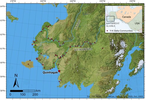
The Yukon-Kuskokwim (Y-K) Delta is one of the largest deltaic systems in the world, spanning over 150,000 ㎢ of coastal mudflats, lakes, sloughs, and rivers (CitationLim et al., 2021) (). For the past 1,400 years this windswept tundra has been home to the Yupiit (sing. Yup’ik) who represent Alaska’s largest Native community. Although archeological evidence suggests that the first Alaskan Natives settled in the arctic 28,000–13,000 years ago, it was not until approximately 1,500 years ago that communities migrated to coastal environments in search of seal, walrus, and whale (CitationDumond, 2005; CitationMasson-MacLean et al., 2020; CitationMorritt, 2011; CitationPedersen et al., 2016; CitationShaw, 1998; CitationSmith & Gleason, 2021; CitationVanStone, 1984). In the Y-K Delta this meant that precontact Yupiit began refining the elaborate Traditional Ecological Knowledge (TEK) and subsistence practices still practiced today among village communities known collectively as Yuuyaraq (trans. ‘The Way We Genuinely Live’). As such, Yuuyaraq is a vital cultural practice that spans both ancient and contemporary coastal landscapes (CitationBarker & Barker, 1993; CitationFienup-Riordan, 1995, Citation2016).
Figure 1. The location of Quinhagak within the Y-K Delta.
Yuuyaraq follows a yearly cycle from frost to thaw along the Bering Sea coast that includes berry picking, hunting, driftwood gathering, trapping, and fishing. As a result, Yupiit in the Y-K Delta have traditionally resided in small coastal villages (n = 58) located along the Bering Sea’s many estuaries and inland rivers. Yet, today, many subsistence traditions associated with Yuuyaraq have been impacted by climate change, rising sea levels, coastal erosion, and melting sea ice. In particular, coastal erosion has made village travel more difficult (CitationCold et al., 2020; CitationMoerlein & Carothers, 2012), threatened ancestral sites associated with Yup’ik material culture (CitationBritton & Hillerdal, 2019; CitationHillerdal et al., 2019), and disrupted contemporary village infrastructure. In fact, coastal erosion has been so severe recently that Yup’ik villages, such as Newtok, have relocated further inland.
One community that has been particularly affected is Quinhagak, a coastal village of approximately 700 individuals at the mouth of the Qanirtuuq and Agalig river systems (). In 2007, Quinhagak residents contacted archeologists to excavate the ancestral site of Nunalleq (GDN-248) before it eroded into the Bering sea (Knecht & Jones, Citation2019). Today, however, attention in Quinhagak has now turned to the wider heritage landscape. Although ancestral Yup’ik place names, such as Nunalleq, provide important information about ancient networks of travel they are also vital sites for contemporary subsistence. For these reasons, additional mapping projects must be undertaken to document Yup’ik place names most at risk from coastal erosion and riverine change.
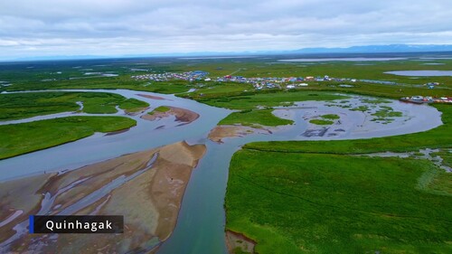
Figure 2. An aerial photo of Quinhagak viewed from the Bering Sea.
2. Methods
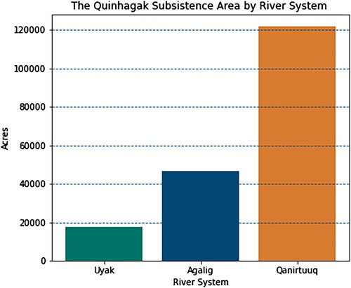
Over the past decade, concerns about erosion along the Qanirtuuq river has been well documented, resulting in several planning projects to mitigate threats to village infrastructure and nearby ANCSA 14(h) Native Allotments established in 1971 under the Alaskan Native Claims Settlement Act (ANCSA) (CitationBuzard et al., 2021a; CitationCommunity of Quinhagak, 2020; CitationCRW Engineering, INC, 2020, p. 2020; CitationHerrera Environmental Consultants, 2019; CitationNorthern Economics, 2010; CitationPowtec LLC & Tetra Tech, 2012; CitationThe City of Quinhagak, 2012). In response to these concerns, this project plots historic marine coastal landscape changes near Quinhagak’s Traditional Land Use Area (TLUA) over the past century (1900-2021). Although the TLUA for Quinhagak is vast– comprising over 184,000 square acres– our area of study encompasses the Qanirtuuq river system since it contains the highest number of subsistence sites per acre (n = 52) and the largest coastal marine area of the three primary rivers near Quinhagak ( and ).
Figure 3. The extents of two maps depicting Quinhagak’s Traditional Land Use Area (TLUA). Such maps were used during interviews with local Yupiit to locate traditional place names, contemporary subsistence sites, and areas of high erosion.
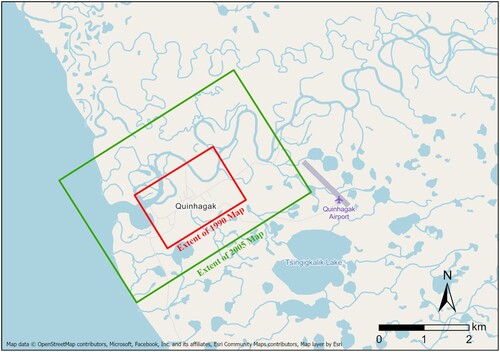
Figure 4. The total area of each river system within Quinhagak’s Traditional Land Use Area.
To document change along the coastal landscape within Quinhagak’s TLUA, we draw from an extensive archive (n = 490) of historic maps, aerial photographs, and surveying reports collected and digitized over the course of numerous on-site visits to work with Qanirtuuq Inc’s. Land Manager’s office from 2018-2021. In addition, we have conducted numerous recorded (n = 7) and unrecorded (n = 42) interviews with knowledgeable community members about recent environmental changes to important Quinhagak place names associated with Yuuyaraq. All maps in the collection depict ancestral subsistence areas, many of which are still in use today. The earliest document in the collection dates to 1901; the latest is from 2021 (). The maps come from a variety of sources, but the most common are maps issued by state and federal agencies. From 2018–2021 these maps were digitized, cataloged, and archived on behalf of Qanirtuuq Incorporated’s Land Manager’s Office. Permission was granted by Qanirtuuq Inc, a ANCSA 14(h) tribal corporation after interviews with current and former land managers to explain the scope and purpose of this digitization effort.
To digitize the collection, photos were taken of the physical map prints using a Leica Q 24-megapixel mirrorless camera with data exported in.DNG format (6000 × 4000) with custom white balance settings. Next, the raw photographs were cropped, color corrected, and exported as.Tiff files in Adobe lightroom. Of the 490 historic maps digitized, a subset (n = 59) was selected for further analysis based on community needs. Images were then imported into ArcGIS Pro 2.9.0 for geo-referencing against VHR imagery (0.46 cm GSD) from the GeoEye-1 satellite hosted on the ESRI living Atlas. Control points (n = 16) for georeferencing were then created by identifying common features excluding rivers, lakes, and coastlines. To measure erosion rates, riverbank and coastline extents from 1990, 2005, and 2019 were traced and digitized as line features. Using this data, point features were generated every one meter across all line features, and the Near tool was used to measure the distance between historic river bank extents to quantify the rate of erosion for each site.
Specific data regarding land use at two focus areas ( and ) were recorded using subsistence maps and archives from past place name projects undertaken by Qanirtuuq Inc’s Land Manager’s office. Together these documents provided precise GIS coordinates regarding the location of place names associated with Yuuyaraq. In select cases, recorded and unrecorded GIS-based interviews were also used with community members to verify the location of a site. During these interviews community members reviewed satellite imagery, historic maps, and digital elevation models (DEMs) of the landscape. Occasionally, researchers also used visual imagery and orthomosaics gathered from UAV flights as well as historic photographs to provide more information for interviewees about a site’s location, use, or change over time (). In total, the two most frequent subsistence activities associated with place names under threat from coastal erosion in Quinhagak’s TLUA were fish processing (n = 14) and berry picking sites (n = 9).
Figure 5. Erosion rates at the City dock and Kuiggacuk. Today, fish racks and modern homes have been relocated as the Qanirtuuq migrates south.
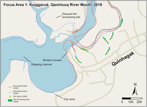
Figure 6. A 2022 map detailing areas where village infrastructure has been lost due to erosion.
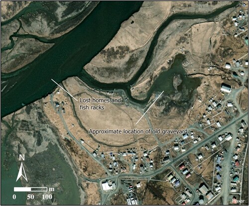
Table 1. A description of the GIS database we have produced since 2019 alongside the Qanirtuuq Land Manager’s office. From this database a subset of GIS layers were used for the 3 traditional place names included within the study area. Alt Text: [11 words] A summary statistics table of the GIS database constructed for this project.
3. Results
Since 2005, the Quinhagak Traditional Land Use Area (TLUA) has experienced increased rates for erosion that threaten Yup’ik subsistence (). From 2005–2009 both the maximum and median rates of erosion rose at sites vital to Yuuyaraq. For instance, at Kuiggacuk slough–-a site located at the mouth of the Qanirtuuq River– riverine erosion has washed out former homes and fish racks (). UAV imagery collected near Kuiggacuk from 2019–2022 also revealed the presence of abandoned fish processing pits north of the Qanirtuuq river. Together these results imply that this area was once a peninsula, which would match local ethnographic accounts by village elders. Today, however, over 100 meters of the peninsula have eroded since 1990. In addition, our analysis suggests that the median rate of erosion at Kuiggacuk has accelerated by half a meter per year over the course of the twenty-first century. In total, over 20 homes, numerous fish racks, ANCSA 14(h) allotments, and the village's original cemetery have been either lost or relocated due to this erosion threat () (CitationPowtec LLC & Tetra Tech, 2012; CitationThe City of Quinhagak, 2012).
Table 2. Rates of erosion of the Qanirtuuq near Quinhagak.
Erosion at Kuiggacuk near the mouth of the Qanirtuuq river exemplifies the impact of anthropocentric climate change on ancient coastal sites of subsistence, travel, and occupation. Notably, coastal and riverine erosion at this site threatens access to ancestral fish processing sites, drying racks, and the old village cemetery. Increased silting from erosion has also made the Qanirtuuq river more difficult to navigate. As a result, villagers have switched from larger 26-foot craft to 10–12 foot v-hulled ‘Lund’ and flat-bottom ‘Jonboat’ vessels with smaller outboard motors for commercial fishing and daily travel (CitationPowtec LLC & Tetra Tech, 2012). Not surprisingly, this switch to smaller smaller marine vessels has coincided with an uptick in aquatic-based Search and Rescue (SAR) missions over the past 20 years. As noted by local SAR team members during interviews, the risks posed by smaller craft are especially concerning for commercial fishermen who must transport their catch to an off-shore tender since larger transport vessels can no longer dock in the village.
While climate change threatens ancestral sites and networks of travel, erosion has also disrupted contemporary infrastructure. For instance, the Quinhagak city dock () is particularly important because coastal Yup’ik villages rely on shipping containers to transport goods that are too heavy or large to deliver by airplane. Increased erosion at the mouth of the Qanirtuuq, however, has meant that nearby shipping channels move unpredictably from year to year. In response, a 2021 erosion risk assessment for Quinhagak underwritten by the Alaska State Department of Natural Resources estimated the total erosion costs for the city dock to be $8.5 million USD from 2056CE-2075CE (CitationBuzard et al., 2021b). Yet, this estimate does not include current erosion costs incurred from channel migration or re-routing over the first half of the twenty-first century (2020-2050). In contrast, village officials we interviewed were adamant that erosion at the city dock already poses serious logistical costs to the village including annual dredging and the increased frequency of stranded cargo vessels. Given nearby erosion levels at Kuiggacuk, it is likely that these cost estimates ($8.5 mil USD) are exceedingly low. In fact, Unmanned Aerial Vehicle (UAV) surveys of the area conducted in 2021 on behalf of Qanirtuuq Inc (https://www.youtube.com/watch?v=zbH3cRgtDZc&t=587s) corroborate local ethnographic accounts of increased erosion.
A second noteworthy case study that illustrates the impact of erosion on Yup’ik subsistence sites is Meqsarturyaraq (trans. ‘Place where one gets fresh water’). Located along the Qanirtuuq river near the village’s old airport runway, Meqsarturyaraq contains important fish processing areas and boat docks that have typified life in the Y-K Delta for more than 1,000 years (). Moreover, our results suggest that these sites are under threat from riverine erosion. In particular, the fish processing areas located at B and C are quickly eroding into the river, while the fish racks at D and G have been lost already. Site F, located on the north bank of the Qanirtuuq upriver from the village is also in jeopardy. Finally, the fish processing area E is partially eroded, but usage of the area is dangerous due to the encroaching river. Given the current erosion rates at Meqsarturyaraq, we estimate the total monetary damages to the seven surrounding fish camps to be $2.1 million USD in the next 10 years using current actuarial rates provided by the Alaska Department of Natural resources (i.e. $300,000 USD per fish camp).
Figure 7. Meqsarturyaraq is a traditional place name near the old Airport in Quinhagak. It has traditionally been used as a boat dock, fresh water access, and fish processing/drying area. Furthermore, its location near berry patches that are close to the village make it an important cultural resource.
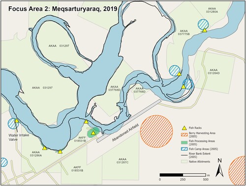
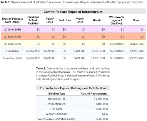
As with Kuiggacuk, UAV surveys conducted in 2021 suggest that Meqsartuyaraq has suffered significant erosion over the first half of the twenty-first century (https://www.youtube.com/watch?v=P27r_00PSNw). In particular, the gravel embankment nearest to the abandoned airport is in immediate threat of failure. Erosion at this location forced the village to relocate it’s airport in 2004 after the village received funding in 1996 from the Department of Transportation and Public Facilities. However, a 2019 environmental assessment report found that failure at this particular location will result in a river reroute into the low lying alluvial floodplain surrounding Quinhagak (CitationCRW Engineering, INC, 2020). When this happens the Qanirtuuq river will submerge important sites associated with Yuuyaraq including fish camps, boat docks, berry picking sites, and individual ANCSA 14(h) Native Allotments. In addition, valuable village infrastructure, notably a new freshwater intake and wastewater lagoon, may be inundated. Temporary Mitigation of this site would cost the village an additional $2.1 million USD. Importantly, these costs have not been factored into the most recent 2021 erosion assessment by the Alaskan DNR, which estimated total erosion damages to be roughly $15.2 million USD from 2022-2075.
4. Discussion
Our results suggest that climate change has accelerated coastal erosion at two key subsistence sites in Quinhagak’s Traditional Land Use Area. Moreover, given the rates of erosion since 1990, we believe that current hazard mitigation plans have drastically underestimated the financial costs of erosion for Yup’ik villages in the Y-K Delta. For instance, the most recent figures provided by the Alaska Department of Natural Resources in 2021 project a total of $15.2 million USD in total erosion damages for the twenty-first century. Importantly, these figures do not include any erosion damages for the years 2000–2056 () (CitationBuzard et al., 2021b). As demonstrated at Kuiggacuk and Meqsartuyaraq, however, riverine and coastal erosion has already significantly disrupted and erased material culture at just two sites associated with Yuuyaraq. At Meqsartuyaraq alone total damages could very well exceed $4.2 million USD when considering the cost of mitigation and the loss of seven fish camps. Accordingly, we advise that Federal and State policy makers consider whether predicted erosion rates are accurate for other rural circumpolar villages in Alaska. Here, data collected in Quinhagak provides comparative evidence that existing erosion modeling may underreport the extent of damages. Whereas current models do not account for substantial erosion until 2056, our analysis shows an median erosion rate in Quinhagak of nearly 8 meters per year since 2005.
Figure 8. 2021 estimates of erosion damages for Quinhagak during the next century. Note the lack of erosion damages for village infrastructure until 2056, and the costs per lost fish camp (300,000). Image courtesy of the Alaskan Department of Natural Resources.
Given threats to ancestral sites, material culture, contemporary subsistence practices, and village infrastructure additional mapping projects must be completed alongside ANCSA 14(h) village corporations to document and study the scope of erosion in the Y-K Delta. Thus, future researchers studying the impact of coastal erosion on Alaskan Native communities should work closely with local ANSCA14(h) land manager’s offices to digitize existing records and conduct qualitative interviews to locate subsistence areas most under threat from climate change. Here, the value of qualitative data to augment mapping efforts can not be understated. In addition, doing so provides ethnographic data and oral histories on the impact of climate change that may be archived for future generations and published via digital deep maps and videos (https://www.youtube.com/watch?v=vUsl7HEOPJA&t=171s, https://storymaps.arcgis.com/stories/23c0920648ad448cb561bf302ff6ba11).
Digitizing existing maps yields important, tangible benefits for both local communities and researchers. It allows local land managers to integrate historical maps in existing GIS layers for local planning. Doing so also provides communities a means to map and quantitatively measure changes to the landscape using tools such as automated change detection. Moreover, when combined with new cultural heritage practices in the Y-K Delta–such as photogrammetry, machine learning, and automated UAV flights–local communities can establish longitudinal datasets to monitor changes to specific sites as a result of coastal erosion and climate change (CitationLim et al., 2021, Citation2022). For instance, at an ancestral berry harvesting site near Quinhagak multispectral vegetation data collected from UAV imagery has been combined with existing, digitized heritage maps to inform local Yupiit about the specific distribution of berries within a given extent. Such data will prove invaluable for local communities given documented concerns by Yupiit about possible changes to subsistence species due to changing environmental conditions in the circumpolar arctic. For these reasons, we recommend the use of UAV based photogrammetry to produce orthomosaics and 3-d models with ground sampling distances that far exceed commercially available satellite imagery (CitationLim et al., 2021, Citation2022). Furthermore, in the context of the Y-K Delta, other sources of historic spatial data may prove useful, particularly the outputs of the Alaska High Altitude Photography program (1978-1986), and recently declassified 2 m resolution Corona satellite imagery from the 1960s to 1980s. Beyond simple visual inspection, stereoscopic pairs of historical aerial images may be processed to develop digital elevation models (DEM’s) from the past (CitationCasana et al., 2012). Such datasets may then be compared with modern elevation models to better quantify landscape change, particularly UAV derived data, or 2 m DEMs hosted on the ArcticDEM initiative (CitationPorter et al., 2018).
Future work with Alaskan Native tribal entities to digitize existing map repositories will provide valuable tools to monitor landscape-wide change to Yuuyaraq sites near coastal waterways. Yet, the value of charting erosion to coastal landscapes transcends the quantitative assessment of coastal erosion. A georeferenced database of historic maps is a vital tool in current language preservation efforts throughout the Y-K Delta that are focused on the Yup’ik place names associated with Yuuyaraq. Over the course of the 20th and 21st centuries many of these names–originally in Yugtun– have been replaced by English names in state, federal, and commercial GIS-based products. Our team hopes that digital preservation efforts yield resources that include deep maps for community members to see coastal change visualized through mobile apps that also retain Yugtun place names to communicate the importance of both place and name for sites associated with Yuuyaraq. Mobile-based development and deployment is aso especially important for circumpolar Indigenous communities given the lack of reliable internet access, and the need to quickly communicate results of erosion reports to all members of a given community. Accordingly, future mapping projects in the Y-K Delta should rely on mobile friendly symbology and clean, minimalist base maps .
5. Conclusion
For the past 1,500 years Yupiit in the Y-K Delta have relied on seasonal subsistence sites, which are located at the confluences of in-land river systems and the Bering Sea (). For this reason, subsistence sites associated with Yuuyaraq have long been under threat from coastal erosion events, and changes to the landscape are an important focus of local oral history (CitationFienup-Riordan & Knecht, 2015). Our goal with this project has been to combine historical maps, satellite data, qualitative inquiry, and UAV surveys to provide the village of Quinhagak with cheap, accurate, and easily communicated maps that can be widely distributed to community members via mobile-based applications. We hope our methodology serves as a reproducible workflow for other scholars interested in working with Yup’ik villages in the Y-K Delta to document the impact of climate change on vulnerable coastal communities.
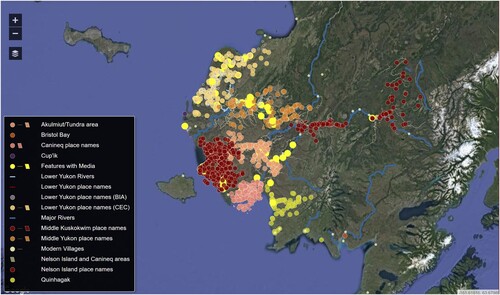
Figure 9. A sample distribution of Yup’ik subsistence place names throughout the Y-K Delta. Image courtesy of the EKOLA environmental Atlas.
Software
UAV and other video footage was edited and compiled in Davinci Resolve 17.2.0. Adobe photoshop and lightroom were used for color correction and cropping on all still imagery. ArcGIS Pro 2.6.0 was used to create map layers and geo-reference files. Adobe audition was used to edit.wav files of recorded interviews. Python 3.10.2 was used alongside the Numpy, OpenCV, and Matplotlib libraries to extract stills from video files, resize imagery, and visualize results for community interviews.
Supplemental Material
Download Zip (6 MB)Acknowledgements
The authors would like to thank the entire team at Qanirtuuq Inc. for generously offering resources, time, and local expertise to the project. Special thanks to Dr. Richard Knecht (The University of Aberdeen) for his guidance and support. Lynn Church (Nalaquq, Inc) was especially helpful for coordinating logistics between various Yup’ik organizations and constituiences. Dr. Fabio Matano (Consiglio Nazionale delle Ricerche) and Angela Rizzo provided valuable feedback in review, and Mr. Steven Bernard’s (Financial Times Ltd) guidance for map layout was extraordinarily insightful. The authors would also like to thank Gaia Mattei and the editorial team of this special issue for their feedback and advice. Quyana cakneq.
Data Availability Statement
The data that support the findings of this study are available from Qanirtuuq Inc, a registered ANCSA 14(h) village corporation in Quinhagak, AK. Restrictions apply to the availability of these data, which were used under license for this study. Data are available from Warren Jones with the permission of Qanirtuuq Inc.
Disclosure statement
No potential conflict of interest was reported by the author(s).
References
- Barker, J. H., & Barker, R. (1993). Always getting ready: Upterrlainarluta : Yup’ik Eskimo subsistence in southwest Alaska. University of Washington Press.
- Britton, K., & Hillerdal, C. (2019). Archaeologies of climate change: Perceptions and prospects. Études Inuit Studies, 43(1-2), 265–287. https://doi.org/10.7202/1071948ar
- Buzard, R. M., Turner, M. M., Miller, K. Y., Antrobus, D. C., & Overbeck, J. R. (2021a). Erosion exposure assessment of infrastructure in Alaska coastal communities. Alaska Division of Geological & Geophysical Surveys, 35. https://doi.org/10.14509/30672
- Buzard, R. M., Turner, M. M., Miller, K. Y., Antrobus, D. C., & Overbeck, J. R. (2021b). Quinhagak:Erosion exposure assessment of infrastructure in Alaska coastal communities. Alaska Division of Geological & Geophysical Surveys, 13. https://doi.org/10.14509/30672
- Casana, J., Cothren, J., & Kalayci, T. (2012). Swords into ploughshares: Archaeological applications of CORONA satellite imagery in the near east. Internet Archaeology, 32, https://doi.org/10.11141/ia.32.2
- Cold, H. S., Brinkman, T. J., Brown, C. L., Hollingsworth, T. N., Brown, D. R. N., & Heeringa, K. M. (2020). Integrating hunter knowledge with community-based conservation in the Pamir Region of Tajikistan. Ecology and Society, 25(1), 1–18. https://doi.org/10.5751/ES-11253-250101
- Community of Quinhagak. (2020). Looking forward, looking back: Building resilience today community report (community report award #A18AP00231; p. 48). Aleutian Pribilof Islands Association.
- CRW Engineering, INC. (2020). Kanektok River Reroute: Conceptual Design Report (p. 150) [Enviromental Monitering]. Qanirtuuq, Inc.
- Dumond, D. E. (2005). The artic small tool tradition in southern Alaska. Alaskan Journal of Anthropology, 3(2), 67–78. https://www.jstor.org/stable/42869667
- Fienup-Riordan, A. (1995). Boundaries and passages: Rule and ritual in Yup’ik Eskimo oral tradition. University of Oklahoma Press.
- Fienup-Riordan, A. (2016). Ciulirnerunak yuuyaqunak = Do not live without an elder: The subsistence way of life in southwest Alaska (A. Rearden, Trans.). University of Alaska Press.
- Fienup-Riordan, A., & Knecht, M. (2015). irr’inarqellriit /amazing things: Quinhagak elders reflect on their past (A. Rearden, Trans.). Alaskan Journal of Anthropology, 13(2), 36.
- Herrera Environmental Consultants. (2019). Quinhagak. Kanektok River Erosion Study (p. 9).
- Hillerdal, C., Knecht, R., & Jones, W. (2019). Nunalleq: Archaeology, climate change, and community engagement in a yup’ik village. Arctic Anthropology, 56(1), 4–17. https://doi.org/10.3368/aa.56.1.4
- Knecht, R., & Jones, W. (2019). “The old village”: Yup'ik precontact archaeology and community-based research at the nunalleq site. Études Inuit. Inuit Studies, 43, 25–52. https://www.jstor.org/stable/26945904
- Lim, J. S., Gleason, S., Jones, W., & Church, W. (2021). Nuna nalluyuituq (The land remembers): remembering landscapes and refining methodologies through community-based remote sensing in the Yukon-Kuskokwim delta, southwest alaska. Archaeological Prospection, 339–355. https://doi.org/10.1002/arp.1840
- Lim, J. S., Gleason, S., Williams, M., Linares Matás, G. J., Marsden, D., & Jones, W. (2022). UAV-Based remote sensing for managing alaskan native heritage landscapes in the Yukon-Kuskokwim delta. Remote Sensing, 14(3), 1–30. https://doi.org/10.3390/rs14030728
- Masson-MacLean, E., Houmard, C., Knecht, R., Sidéra, I., Dobney, K., & Britton, K. (2020). Pre-contact adaptations to the little Ice Age in southwest Alaska: New evidence from the nunalleq site. Quaternary International, 549, 130–141. https://doi.org/10.1016/j.quaint.2019.05.003
- Moerlein, K. J., & Carothers, C. (2012). Total environment of change: Impacts of climate change and social transitions on subsistence fisheries in northwest Alaska. Ecology and Society, 17(1), 10. https://www.jstor.org/stable/26268996, https://doi.org/10.5751/ES-04543-170110
- Morritt, R. D. (2011). Beringia: Archaic migrations into North America. Cambridge Scholars Pub.
- Northern Economics. (2010). An economic analysis of runway extensions (No. D59825; p. 152). Alaskan Department of Transportation and Public Facilities. https://www.alaskaasp.com/admin/Docs/Runway%20Extension%20Analysis%20Report_-%20FINAL%207-26-10.pdf.
- Pedersen, M. W., Ruter, A., Schweger, C., Friebe, H., Staff, R. A., Kjeldsen, K. K., Mendoza, M. L. Z., Beaudoin, A. B., Zutter, C., Larsen, N. K., Potter, B. A., Nielsen, R., Rainville, R. A., Orlando, L., Meltzer, D. J., Kjær, K. H., & Willerslev, E. (2016). Postglacial viability and colonization in North America’s ice-free corridor. Nature, 537(7618), 45–49. https://doi.org/10.1038/nature19085
- Porter, C., Morin, P., Howat, I., Noh, M.-J., Bates, B., Peterman, K., Keesey, S., Schlenk, M., Gardiner, J., Tomko, K., Willis, M., Kelleher, C., Cloutier, M., Husby, E., Foga, S., Nakamura, H., Platson, M., Wethington, M., Williamson, C., … Bojesen, M. (2018). ArcticDEM [Data set]. Harvard Dataverse.
- Powtec LLC, & Tetra Tech. (2012). Quinhagak hazard impact assessment (p. 60). The City of Quinhagak. https://www.commerce.alaska.gov/web/Portals/4/pub/Quinhagak%20HIA%20Main%20Report_FINAL%20112112.pdf.
- Shaw, R. D. (1998). An archaeology of the central yupik: A regional overview for the Yukon-Kuskokwim delta, northern Bristol Bay, and nunivak island. Artic Anthropology, 35(1), 234–246. https://www.jstor.org/stable/40316467
- Smith, J., & Gleason, S. (2021). “Knowledge is like food”:qanruyuteton change and subsistence from John Smith. Text and Performance Quarterly, 41(1-2), 37–60. https://doi.org/10.1080/10462937.2021.1916583
- The City of Quinhagak. (2012). City of Quinhagak Hazard Mitigation Plan (p. 172) [Enviromental Monitering]. https://www.commerce.alaska.gov/web/Portals/4/pub/Quinhagak%20-%20Jan%202012.pdf.
- VanStone, J. (1984). Mainland southwest Alaska eskimo. In D. Demas (Ed.), Handbook of North American Indians: Artic (pp. 224–242). Smithsonian Institute Press.