
ABSTRACT
We present and discuss the results of a geomorphological and geological study aimed at reconstructing the Plio-Quaternary evolution of the NW Sicily coastal belt , a low strain rate region in the central Mediterranean Sea.
We performed morphometric and field analysis of Quaternary marine terraces extracting more than 300 shoreline location points subdivided into six orders. The obtained dataset was validate by investigating the morphological changes along topographic profiles and comparing the extracted locations and elevations with the stratigraphic boundaries in the Plio-Quaternary units.
We distinguished two contiguous coastal sectors characterized by different paleo-shoreline elevations and Plio-Quaternary evolution, whose estimated uplift rates fit well with the well-known, regional eastward uplift rate increase along the Northern Sicilian continental margin.
Obtained results, summarized in a geomorphological map and a morpho-evolutionary model, provide new valuable data to characterize the active deformation processes and the seismotectonic setting in this critical sector of the Africa-Europe plate boundary.
1. Introduction
The evolution of the coastal landscape is driven by the continuous interaction between tectonics and climate. Indeed, these forcings indirectly control the development of specific geomorphological processes, inducing migration of the sea level through differential vertical tectonic movements and glacio-eustatic oscillations, resulting in alternating erosional and depositional cycles. Considering the above, the coastal landscape topography can be assumed as the result of the tectonic and climate signals and, thus, an archive recording information about the variation of these two drivers through time.
Some primary markers resulting from the interaction of these two signals are paleoshorelines, marine terrace sequences and unconformity-bounded stratigraphic units (sensu CitationSalvador, 2013; CitationChang, 1975). The joint analyses of these markers allow the reconstruction of the landscape evolution and, in this case, the quantification of the differential vertical movements providing crucial data for tectonic dynamics and seismic hazard assessment (e.g. CitationFerranti et al., 2021; CitationGarrote et al., 2008; CitationSulli et al., 2013).
The Northern Sicilian Continental Margin (NSCM) is a low-strain rate region located along the plate boundary of the slowly converging African and European plates (see ‘Regional framework sketch’ in the Main Map, CitationSulli et al., 2021a) and is a puzzling region resulting from the interaction of two different geodynamic processes. The western and central parts of the margin are characterized by processes resulting from the Africa-Europa collision, in which the African-thinned continental crust subducts beneath the European Sardinian and Kabylian-Calabrian units (CitationSulli et al., 2021b, and reference therein). Differently, its rapidly uplifting eastern portion is controlled by the subduction of the Ionian oceanic lithosphere beneath the European Calabrian Arc (CitationMeschis et al., 2018, Citation2019). The whole NSCM is characterized by a low seismic moment release, an active shortening with rates close to 1 mm/yr and by elusive active faults not fully identified and characterized yet (CitationDevoti et al., 2017; CitationDISS Working Group, 2021; CitationParrino et al., 2022; CitationRovida et al., 2021; CitationSulli et al., 2021b).
Several studies investigated the differential vertical movements in the eastern sector of the NSCM (Peloritani Mountains), analyzing the Quaternary marine terraces, the drainage network, the offshore morphobathymetric setting, and the sedimentary architecture (CitationAntonioli et al., 2006, Citation2018; CitationCosentino & Gliozzi, 1988; CitationFerranti et al., 2006; CitationHugonie, 1981; for a review see CitationCerrone et al., 2021). Conversely, there are still few attempts to investigate the Quaternary uplift history of the central and western sector of the NSCM and, thus, its recent landscape evolution is still a matter of debate (CitationAgate et al., 2017; CitationCatalano et al., 2010a, Citation2010b, Citation2011, Citation2013a; CitationDi Maggio et al., 2009, Citation2017).
We present a review of the most up-to-date literature and a new morphometric dataset extracted from a digital elevation model of the western sector of the central NSCM in order to reconstruct its geomorphological evolution. The proposed dataset could represent a valuable tool for new studies on identifying and characterizing active faults, potential input data for seismic hazard assessment, and landscape evolution forecasting scenarios.
2. Study area and geological and geomorphological overview
2.1. Study area
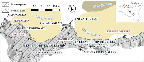
The NSCM develops on the northern coast of Sicily and in the southern Tyrrhenian Sea as the southernmost prosecution of the Apennine-Maghrebian fold and thrust belt, a subduction-collisional boundary between Europa, Africa and Ionian plates. The study area includes two low-relief coastal plains in the central western sector of the NSCM between the city of Palermo and Termini Imerese (). The area is marked by the NNW-SSE elongated Palermo plain and the WNW-ESE oriented Termini plain. Mountain ranges surround the Palermo plain to the inland and open to the sea, while a hilly landscape, interrupted by an NNW-SSE oriented carbonate ridge in its central portion, borders the Termini plain to the South.
Figure 1. Map of the western portion of the central Northern Sicily Continental Margin. The yellow-shaded areas represent the offshore extent of the Palermo and Termini basins. The polygons with different patterns represent the inland extent of the two basins (Palermo plain and Termini plain, respectively). Please check, in the main map, the ‘Regional structural sketch’ and the ‘location of the investigated area in the central Mediterranean region’ for a broader geographical setting.
2.2. Stratigraphy
Two different Plio-Quaternary successions crop out in the western and eastern sectors of the study area (), representing the infilling of two different sedimentary basins (; CitationAgate et al., 2017; CitationDi Maggio et al., 2009; CitationDominici et al., 2020; CitationIncarbona et al., 2016; CitationLo Iacono et al., 2014; CitationMartorana et al., 2018; CitationMilia et al., 2021). Both successions lie unconformably on a deformed substrate that is constituted by rocks that are indicative of shallow to deep water marine environments. Excluding the Messinian crisis, these environments persisted from the Triassic to the early Pliocene, when the Trubi unit (Zanclean) deposition was completed, and the first areas of Sicily began to emerge (CitationDi Maggio et al., 2017).
Figure 2. Geological map of the study area, where stratigraphic units and main tectonic structures of the Plio-Quaternary are detailed; on the right, the stratigraphic log of the Palermo and Termini basins. AFL – Capo Plaia synthem; RFR – Raffo Rosso synthem; SIT – Barcarello synthem; BNI – Benincasa synthem; BCP – Buonfornello-Campofelice synthem; MRS – Marsala synthem; ALT – Altavilla Sands unit; TRB – Trubi unit (see text for the description of the stratigraphic units).
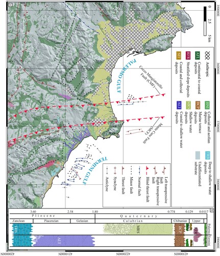
To the west, the Palermo Basin ( and ) is made up of less than 100 m thick deposits, corresponding to the Marsala synthem (MRS; middle-late Calabrian, 1.5–0.77 Ma; CitationDi Maggio et al., 2009 and reference therein).
The base of the succession is made up of a 40–50 m thick package of thin conglomerate beds that upwards and laterally passes to foraminifera bearing bluish clays with interbedded sandy-silty horizons forming the Ficarazzi clays unit (). The Ficarazzi clays gradually pass upward to yellowish calcarenites and sands with interbedded microconglomerate horizons, constituting the ca. 20 m thick Palermo calcarenites unit (CitationCatalano et al., 2013a; ).
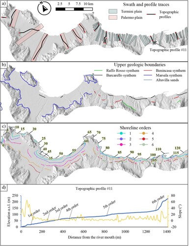
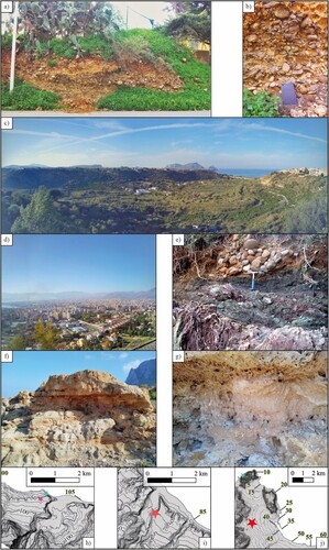
Figure 3. (a) Map of the swath profile boxes and topographic profile traces, oriented towards the maximum slope direction, in the Palermo and Termini plains; (b) map of the upper geologic boundaries of RFR, SIT, BNI, MRS, and ALT; (c) map of the detected shoreline angles orders in the study area; the numbers highlighted in yellow represent the distances (in km) along the coastline starting at the westernmost location on the map; the succession is complete in the Termini plain; the sixth order is missing in the Palermo plain; (d) topographic profile #11; the thick blue line represents the elevations, the thin orange line represents the slope value, the black arrows indicate the location of the six detected shoreline angles orders.
The Termini basin () is a WNW-ESE partially offshore Plio-Quaternary basin adjacent to the eastern termination of the Palermo basin and limited northward by the intraslope Termini ridge (). Within this sedimentary basin, deposits show 80 m thick sedimentary packages of alluvial conglomerates (3.6–3.1 Ma), deltaic sandstones, deltaic-pebbly sandstones, inner-shelf mudstones, colluvium deposits and paleosoils of the mid-Piacenzian – early Gelasian (about 3.1–2.5 Ma) Altavilla Sands (ALT) unit (CitationDominici et al., 2020; ). The lower part of the succession shows an arrangement from alluvial fans to delta front to open shelf paleoenvironment, reflecting deepening environmental conditions; evidence of subaerial, flood-dominated fluvio-deltaic deposition suggests high slope values of sediment source areas like the modern topography. Thin mudstone intervals, proximal delta coarse-grained sediments, paleosoils, and alluvial fan deposits in the upper part of the succession highlight an initial sediment bypass to deeper marine settings followed by an accommodation space decrease. The top of the succession is truncated by an erosive surface that has erased the most recent layers (CitationDominici et al., 2020). Along the areas close to the coastline, MRS deposits cover the ALT unit (CitationCatalano et al., 2013a).
Above the ALT and MRS deposits, the middle-late Pleistocene sedimentary succession develops upwards in the Palermo and Termini basins (). Few meters thick lens-shaped sedimentary bodies, consisting of continental to coastal/marine deposits enclosed between unconformity surfaces of regional extent, occur along the emerged areas of the plains of Palermo and Termini. These bodies have been organized in unconformity-bounded stratigraphic units (synthems) and correlated to Marine Isotope Stages (MISs) by CitationDi Maggio et al. (2009). The Piana di Partinico synthem (locally Buonfornello-Campofelice synthem – BCP) consists of several cycles of marine terrace deposits related to sea-level high stands (MISs 17–7) lying on wave-cut platforms. The Polisano synthem (locally Benincasa synthem – BNI) is constituted by aeolian and colluvial deposits related to MIS 6, lying on a non-depositional or subaerial erosion surface. The Barcarello synthem (SIT) is composed of marine terrace deposits related to MIS 5.5, bearing a warm-temperate fauna including Thetystrombus latus (commonly known as Strombus bubonius) and lying on a wave-cut platform; laterally and vertically, these deposits pass into welded colluvial deposits related to MIS 5, lying on a continental erosion surface. Raffo Rosso synthem (RFR) encompasses thick stratified slope deposits of the last glacial climate (MISs 4-2), lying on a non-depositional surface.
The top of the successions consists of Holocene marine (submerged areas) or coastal, fluvial, colluvial, aeolian and gravity (emerged areas) deposits. Coastal and continental deposits (Capo Plaia synthem – AFL) up to 20 m thick (CitationMartorana et al., 2018) lie on subaerial erosion or non-depositional surfaces.
The sea-level fluctuations significantly controlled the depositional history of the Palermo basin, reflecting discontinuous and repeated episodes of coastal to shelf sedimentation bounded by unconformities. From the Holocene highstand (from 7.0–8.0 ka), the coastal plain recorded continental and transitional sedimentation that persisted until historical times (CitationIncarbona et al., 2016 and reference therein).
The syn-depositional tectonic activity in the Termini basin is supported by significant unconformities and the difference in dip direction values between the lower and upper parts of the succession of the ALT unit of N345E and N10E, respectively. The latter also highlights the tectonic forcing on the fluvial drainage geometry through which a fluvial system flowing towards the NW during Pliocene times was deflected to NE during the early Pleistocene (CitationDominici et al., 2020).
2.3. Tectonics
The study area belongs to the western sector of the central NSCM (see ‘Regional framework sketch’ in the Main Map), where two different geodynamic processes coexist, such as the Ionian oceanic slab hinge retreat and the continental collision between the Sardinia-Corsica microplate and north African margin (CitationCatalano et al., 2013b; CitationDi Stefano et al., 2015; CitationFaccenna et al., 2004; CitationSulli et al., 2021b). The collisional system developed since the early Miocene through two thin- and thick-skinned thrusting phases. Such shortening phases involved the Meso-Cenozoic silico-carbonate succession developed on the African passive continental margin and locally re-activated Mesozoic extensional structures (CitationAvellone et al., 2010; CitationCatalano et al., 2013b; CitationGasparo Morticelli et al., 2015; CitationGugliotta & Gasparo Morticelli, 2012; CitationGugliotta et al., 2014; CitationParrino et al., 2019). Fault-controlled structural highs, due to the late Miocene–early Pliocene shortening (the second shortening phase), bounded a series of intraslope basins formed in response to the progressive SE retreat of the Ionian slab (CitationKastens et al., 1988; CitationLo Iacono et al., 2014). About 0.8 Ma ago, a tectonic reorganization of the convergent Nubia-Eurasia margin occurred in the central Mediterranean. This reorganization triggered the ongoing shortening process and the regional uplift driven by the Africa-Eurasia lithospheric collision (CitationDi Maggio et al., 2017; CitationGoes et al., 2004; CitationSulli et al., 2021b; CitationZitellini et al., 2020). The computed GNSS velocity fields, together with coastal erosional features, provide information highlighting a slow NNW-SSE oriented convergence with a velocity ranging around 1 mm/yr and a slow regional uplift of about 0–24 mm/kyr in the area (CitationDevoti et al., 2017; CitationFerranti et al., 2006). In the study area, the crustal shortening is taken up by the NNW-SSE trending, transpressional Monte Cane and Cozzo Mangiatorello faults (CitationParrino et al., 2022; ).
2.4. Geomorphology
The study area shows a landscape marked by significant and discontinuous topographic lows consisting of a seaward flat bottom (coastal plain) and bounded inland by wide, over 100m-high, tectonically controlled abandoned coastal cliffs. The present-day topography results from the interaction between differential uplift, river incision, and eustatic changes. Such processes influenced by the formerly originated structural and stratigraphic features drove the landscape evolution of this area (CitationDi Maggio et al., 2017). The result of such evolution consists of a staircase of marine terraces alternated with broad polycyclic marine surfaces near the coast and mountain ranges to the inland (CitationDi Maggio et al., 2017; CitationHugonie, 1981; CitationMauz et al., 1997). The landforms in the inland portion highlight that river incision, karst phenomena, differential erosion and planation processes characterize the active morphotectonic processes within the investigated area (CitationAgnesi et al., 2000; CitationDi Maggio, 2000; CitationDi Maggio et al., 2012, Citation2014). Uplifted Middle-Upper Pleistocene marine terraces are carved into Calabrian (1.8 Ma to 0.77 Ma) coastal to neritic deposits (MRS) forming the coastal plains or older rocks and develop from the sea level up to about 100–300 m a.s.l. (CitationCatalano et al., 2010a, Citation2010b; CitationDi Maggio, 2000).
3. Methods
The map presented here is the result of the review of recent literature (CitationAgate et al., 2017; CitationCatalano et al., 2010a, Citation2010b, Citation2011, Citation2013a; CitationDi Maggio et al., 2009; CitationDominici et al., 2020 and reference therein), field survey and morphometric analyses performed on a LiDAR-derived digital elevation model provided by the Regione Siciliana over the whole Sicilian territory (CitationRegione Siciliana, 2010).
Morphometric analyses were performed following the TerraceM approach (CitationJara-Muñoz et al., 2019) to detect the shoreline angle locations through 52 swath profiles roughly perpendicular to the coastline and covering almost the entire study area.
The obtained dataset was validated by investigating the altitude and slope variations along topographic profiles oriented towards the maximum slope direction. Furthermore, an additional dataset validation was performed by comparing the extracted shoreline angle locations and elevations with the highest lithological boundaries of the Plio-Quaternary succession outcropping in the study area, such as the upper limits of the MRS, ALT, BNI, and SIT and manually checking the locations of these points through satellite imagery (Google Earth imagery, freely accessible at: https://earth.google.com/web/).
We analyzed the elevation of the validated shoreline angle dataset into a distribution along the coastline vs elevation chart to check the data reliability and exclude remaining outliers. Through an in-house developed semi-automatic geospatial model, to minimize the perspective distortion in the distribution along the coastline vs elevation chart, we projected shoreline angle points along the coastline extracting the line describing the minimum distance between each point and the coastline. Then we computed the distance between the intersection of each minimum distance line and the coastline, starting from a point selected along the coastline at the western boundary of the study area. The distribution along the coastline vs elevation chart allowed us to validate the paleoshore elevation outliers, checking if a reliable lateral continuity characterized the detected orders along at least one of the two studied plains.
Detailed field surveys were performed using published topographic base maps (1:10,000 scale maps of the Carta Tecnica Regionale, CTR, provided by the Regione Siciliana and accessible at: https://www.sitr.regione.sicilia.it/cartografia/carta-tecnica-regionale/) aiming at the validation of the shoreline elevation and collecting in the field both lithological and geomorphic evidence of paleo-sea levels into critical sectors of the study area. Moreover, the field survey allowed the discrimination of paleo-sea level orders in sectors not characterized by easily recognizable morphometric signatures of relatively uplifted shoreline angles.
Satellite imagery interpretation and geomorphological field surveys allowed the recognition of the prominent landforms in the study area, which have been arranged based on the process responsible for their origin and represented in the geomorphological map (see the Main Map) using polygons and ‘full coverage’ techniques, where the whole topographic surface is ‘interpreted’ seamlessly (CitationBufalini et al., 2021 and reference therein).
4. Results
The geomorphological surveys carried out in the study area are summarized in a geomorphological map (see the Main Map) showing: (1) a large polycyclic marine terrace surface along the Palermo plain, which develops between about 10–125 m a.s.l. carved in the MRS deposits; (2) a large polycyclic marine terrace surface along the western Termini plain, which develops between 25–200 m a.s.l. carved in the deposits of ALT; (3) a staircase of at least six orders of marine terraces in the eastern Termini plain (Termini Imerese area), which develops between about 20–300 m a.s.l. carved in the pre-Pliocene rocks, with abrasion surfaces covered by the BCP deposits; (4) SIT deposits on an abrasion surface that develops in the areas closest to the coast, which is discontinuous in the Palermo plain (where its inner margin is about 10 m a.s.l., at the foot of small cliffs 1–2 m high) and continues in the Termini plain (where its inner margin is about 15 m, at the foot of large cliffs about 10 m high); (5) wide abandoned cliffs tens of meters high, which internally delimit the succession of marine terraces; (6) a relief dissected by deep river valleys, indicative of prevailing incision processes.
The overall unfiltered data allowed us to recognize eight shoreline elevation orders; however, only six are characterized by a reliable continuity along the investigated area ((c)). According to average elevations of the ground surface determined by analyzing the shoreline angle points, the first order shoreline angle located at c. 10 m a.s.l., the second order at c. 24 m a.s.l., the third order at c. 40 m a.s.l., the fourth at c. 68 m a.s.l, the fifth at c. 100 m a.s.l. and the sixth at c. 119 m a.s.l.
The overall statistical parameters of the detected shoreline angle elevation dataset are summarized in .
Table 1. Statistical parameters of the shoreline angles elevation dataset. Most parameters refer to the overall linear regression of the shoreline angle points detected in both plains. The last two columns highlight the difference in the regression slope lines computed for the two plains separately.
We detected five orders of shoreline angles elevation points, and the fourth and fifth orders roughly correspond to the lateral, pinch-out termination of the MRS deposits (the most elevated mapped limit of Quaternary deposits, dated to 1.5–0.77 Ma, see ) in the Palermo plain. Differently, in the Termini plain, we detected six orders of shoreline angle points and the fifth and sixth order locate in the surrounding of the BNI (late Chibanian – MIS 6) upper elevation outcrops (). Elevation points of the first order lie near the upper elevation outcrops of the SIT (Upper Pleistocene – MIS 5.5), along the whole coastline of the study area ().
Field surveys allowed the detection of 29 paleo-sea level marks from 7 locations in a rocky coastal sector of Termini plain, whose topographic features do not show enough constraints to be interpreted solely by morphometric techniques. Such evidence consists of tidal notches, marine sedimentary bodies, marine fossils, and marine fossil traces ( and ), as recognized by previous investigations within the Mediterranean realm (e.g. CitationArmijo et al., 1996; CitationDe Santis et al., 2021; CitationFerranti et al., 2006; CitationRobertson et al., 2019, Citation2020) and allowed us to validate the first 5 of the 6 shoreline angles orders morphometrically recognized in the whole study area.
Figure 4. Field evidence of fourth-order paleoshorelines, detected in the eastern sector of the study area, and panoramic view of the different order marine terraces in the Termini plain: (a) fragmented marine fossils within a coastal deposit of BCP; (b) evidence of Lithophaga holes; (c) the black arrows point to traces of Cliona vastifera orange sponges, which are also interested by Lithophaga holes; the white dashed line highlights the morphology of the studied smoothed tidal notch (sensu CitationAntonioli et al., 2018); (d) panoramic view of the 2° up to the 5° shoreline angles orders; (e) map view of surveyed sites, shown as stars; the Colour code highlights the five shoreline angle orders in the inset (e).
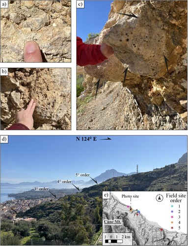
Figure 5. (a) and (b) Marine terrace deposits (BCP) of third order paleoshorelines detected in the Termini plain (for location see box h, magenta star); (c) the wide polycycle marine terrace surface cut into the ALT deposits by the Milicia River, in the Altavilla area – Termini plain (see box i, red star); (d) the wide polycycle marine terrace surface carved on MRS deposits, on which the city of Palermo stands – Palermo plain (see box j, red star); (e) coastal deposits (SIT) on a MIS5.5 wave-cut platform carved in pre-Pliocene rocks, along the Termini plain (see box h, light green star); (f) coastal and colluvial deposits (SIT) on a MIS5.5 wave-cut platform carved in MRS deposits (see box j, light green star); (g) detail of f, with interdigitated colluvial deposits, marked by a stone line structure, among coastal deposits.
The elevation of the detected shoreline angle orders highlight that almost all the identified shoreline orders are located at higher elevations in the Termini plain than in the Palermo plain (), indicating differential uplift rates between the two sectors (see chapter 5).
Such results agree with the fault-related deformation detected in this area by CitationParrino et al. (2022), which is also supported by the different slope values of the regression lines computed in the two plains separately.
5. Discussion and conclusions
Our results show that the two investigated contiguous Palermo and Termini plains have been affected by differential tectonic uplift and subsidence, controlling the coastal landscape evolution in the Plio-Quaternary. Geomorphological evolution has been reconstructed from the Zanclean to the Holocene and summarized in for the investigated area.
Table 2. Summary of the coastal evolution of the Palermo and Termini plains (please, see the evolution model in the Main Map for the graphical representation).
The Calabrian deposits of the MRS post-date the succession of marine terraces; the marine terrace deposits of BCP and SIT confirm that the succession occurred during sea-level highstands of the Chibanian–late Pleistocene, similarly to other areas of northern Sicily (e.g. Mauz et al., Citation1997; CitationDi Maggio et al., 2017 and references therein). The horizontal distance between the shorelines in the Palermo plain is, on average, longer than the corresponding distance in the Termini plain (, ). This characteristic is recognizable in all the marine terrace orders even if it is particularly evident for the shorelines of the first three orders. This observation could be due to different pre-existing morphologies. Based on the interpretation of the geometry of these shorelines and considering its known structural pattern, the Palermo plain paleo-landscape can be interpreted as a partially submerged flat area whose basin fill could be associated with the filling processes of a hinterland basin as documented in surrounding areas (CitationPepe et al., 2003). In a completely different way, the interpretation of the geometry of the paleoshorelines and its sedimentary record highlight that significantly large steep slopes overlooking the sea, structurally controlled, characterized the ancient topography of the Termini plain as in the present ( and , and ). Such high slope values could probably be related to a higher regional uplift of this coastal sector that was superposed to short wavelength uplift patterns due to compressional active faults. Such an interpretation fits the landscape evolution proposed by CitationParrino et al. (2022) and provides new clues about the recent tectonic activity of this coastal sector.
Figure 6. Shoreline angles order distribution along coastline vs elevation along the coastline (see for the map view of these data). The thin red lines represent the locations of two actively deforming faults crossing the investigated coastline and are labelled Cozzo Mangiatorello fault (CMf) and Monte Cane fault (MCf), respectively (CitationParrino et al., 2022).
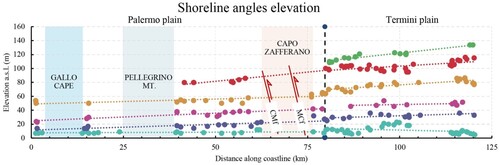
In the Palermo plain, numerous authors identify the MIS5.5 (roughly 125 ka) in correspondence to the first order of the shoreline elevation we mapped at roughly 10 m a.s.l. (see and Figure 7; CitationHugonie, 1981 and references therein; Di Maggio et al., Citation2009; Di Maggio et al., Citation2017 and references therein). The morpho-stratigraphic evidence of MIS5.5-related paleoshorelines was detected in the vicinity of the localities of Capo Gallo and Capo Zafferano (see ; CitationCerrone et al., 2021; CitationDi Maggio et al., 2009 and reference therein). CitationDi Maggio et al. (2009 and reference therein) indicate the existence of SIT coastal deposits on the MIS5.5 marine terrace also in the Termini plain (shoreline elevation is on average 15 m a.s.l.). Considering a sea level value of ca. + 4 m with respect to the present for MIS5.5 (CitationRohling et al., 2009) and based on the elevation of our first order paleoshoreline, an uplift of about 6m and 11m in 125 ky occurs for the plain of Palermo and Termini, respectively. As a result, the post MIS5.5 average uplift rate ranges from 0.048 mm/yr, in the Palermo plain, to 0,088 mm/yr in the Termini plain. These rates are slightly higher than those proposed in the literature for the Palermo plain, which varies from −0.03 mm/yr to 0.01 mm/yr (CitationAntonioli et al., 2006, Citation2018; CitationFerranti et al., 2006). Similarly, the uplift rate for the Termini plain, which is almost two times larger than those calculated for the Palermo plain, well fit with the regional increase in uplift rates recorded from W to E along the coast of the NSCM (CitationCosentino & Gliozzi, 1988). In agreement with CitationRoberts et al. (2013), CitationMeschis et al. (2018) and CitationRobertson et al. (2019), the higher values of uplift rate of the Termini plain are compatible with the higher number of uplifted palaeoshorelines preserved in this plain.
This study may represent the basis for future works where ages for un-dated palaeoshorelines are assigned, and better-refined uplift rates are estimated by applying a synchronous correlation approach to study crustal deformation and active faults (e.g. CitationDe Santis et al., 2021; CitationMeschis et al., 2022; CitationRoberts et al., 2013; CitationRobertson et al., 2019). This approach would allow us to overcome the overprinting or re-occupation problem that often affects regions such as the one investigated in this paper. Finally, the flawless fault-controlled uplift rate may likely be used to derive refined throw rates through time for the active thrust faults deforming our mapped paleoshorelines herein.
Considering the above, the two areas of the investigated NSCM coastal sector were characterized by different paleo-morphologies and slightly different uplift rates, which, together with the Quaternary eustatic oscillations, drove two significantly different landscape evolutions in adjacent sectors. The presented dataset and uplift rates are consistent with the previous studies in the Palermo plain area and provide new information regarding the Termini plain area. Moreover, the overall vision allowed by the carried-out review work made it possible to reconstruct for the first time the coastal landscape evolution of this coastal sector of the NSCM. The achieved results are helpful insights that fill the knowledge gap about the recent landscape evolution and related tectonic forcings and represent a critical tool for parametrizing active geological structures in the area.
Software
QGIS 3.22.1-Białowieża, MATLAB, TopoToolbox (CitationSchwanghart & Scherler, 2014) and TerraceM-2 were used for the morphometric analyses; Adobe Illustrator (CitationAdobe Inc., 2019) was used for the vector-based production of the Map.
Declaration of interest
The authors reported no potential competing interests.
Supplemental Material
Download ()Acknowledgements
We thank the three reviewers, Ana Costa, Marco Meschis and Ettore Valente, who contributed to the improvement of the manuscript thanks to their helpful suggestions and positive comments.
Disclosure statement
No potential conflict of interest was reported by the author(s).
Data availability statement
The authors confirm that the data supporting the findings of this study within the article and its supplementary materials are freely available.
Additional information
Funding
References
- Adobe Inc. (2019). Adobe Illustrator https://www.adobe.com/products/illustrator.html.
- Agate, M., Basilone, L., Di Maggio, C., Contino, A., Pierini, S., & Catalano, R. (2017). Quaternary marine and continental unconformity-bounded stratigraphic units of the NW Sicily coastal belt. Journal of Maps, 13(2), 425–437. https://doi.org/10.1080/17445647.2017.1314229
- Agnesi, V., De Cristofaro, D., Di Maggio, C., Macaluso, T., Madonia, G., & Messana, V. (2000). Morphotectonic setting of the Madonie area (central northern Sicily). Memorie della Società Geologica Italiana, 55, 373–379.
- Antonioli, F., Ferranti, L., Stocchi, P., Deiana, G., Lo Presti, V., Furlani, S., Marino, C., Orru, P., Scicchitano, G., Trainito, E., Anzidei, M., Bonamini, M., Sansò, P., & Mastronuzzi, G. (2018). Morphometry and elevation of the last interglacial tidal notches in tectonically stable coasts of the Mediterranean Sea. Earth-Science Reviews, 185(June), 600–623. https://doi.org/10.1016/j.earscirev.2018.06.017
- Antonioli, F., Kershaw, S., Renda, P., Rust, D., Belluomini, G., Cerasoli, M., Radtke, U., & Silenzi, S. (2006). Elevation of the last interglacial highstand in Sicily (Italy): A benchmark of coastal tectonics. Quaternary International, 145-146, 3–18. https://doi.org/10.1016/j.quaint.2005.07.002
- Armijo, R., Meyer, B. G. C. P., King, G. C. P., Rigo, A., & Papanastassiou, D. (1996). Quaternary evolution of the corinth rift and its implications for the late cenozoic evolution of the aegean. Geophysical Journal International, 126(1), 11–53. https://doi.org/10.1111/j.1365-246X.1996.tb05264.x
- Avellone, G., Morticelli, M. G., Sulli, A., Barchi, M. R., & Catalano, R. (2010). Interference between shallow and deep-seated structures in the Sicilian fold and thrust belt, Italy. Journal of the Geological Society, 167(1), 109–126. https://doi.org/10.1144/0016-76492008-163
- Bufalini, M., Materazzi, M., De Amicis, M., & Pambianchi, G. (2021). From traditional to modern ‘full coverage’ geomorphological mapping: a study case in the Chienti river basin (Marche region, central Italy). Journal of Maps, 17(3), 17–28. https://doi.org/10.1080/17445647.2021.1904020
- Catalano, R., Avellone, G., Basilone, L., Contino, A., Agate, M., Di Maggio, C., Lo Iacono, C., Sulli, A., Gugliotta, C., & Gasparo Morticelli, M. (2013a). Carta geologica d’italia alla scala 1: 50.000, Foglio 595 Palermo. ISPRA, Servizio Geologico d’Italia, Regione Siciliana, Assessorato Territorio ed Ambiente. Https://www.isprambiente.gov.it/Media/carg/sicilia.html
- Catalano, R., Avellone, G., Basilone, L., Contino, A., Agate, M., Gugliotta, C., Di Maggio, C., Di Stefano, E., Gennaro, C., & Arnone, M. (2011). Carta geologica d’italia alla scala 1: 50.000, Foglio 609-596 Termini Imerese—Capo Plaia. ISPRA, Servizio Geologico d’Italia, Regione Siciliana, Assessorato Territorio ed Ambiente. Https://www.isprambiente.gov.it/Media/carg/sicilia.html.
- Catalano, R., Avellone, G., Basilone, L., Gasparo Morticelli, M., Lo Cicero, G., Gugliotta, C., Di Maggio, C., Contino, A., Albanese, C., & Lena, G. (2010a). Carta Geologica d’Italia alla scala 1: 50.000, Foglio 608 Caccamo. ISPRA, Servizio Geologico d’Italia, Regione Siciliana, Assessorato Territorio ed Ambiente. Https://www.isprambiente.gov.it/Media/carg/sicilia.html.
- Catalano, R., Avellone, G., Basilone, L., & Sulli, A. (2010b). Carta Geologica d’Italia alla scala 1: 50.000, Foglio n. 607 Corleone ISPRA, Servizio Geologico d’Italia, Regione Siciliana, Assessorato Territorio ed Ambiente. Https://www.isprambiente.gov.it/Media/carg/sicilia.html.
- Catalano, R., Valenti, V., Albanese, C., Accaino, F., Sulli, A., Tinivella, U., Gasparo Morticelli, M., Zanolla, C., & Giustiniani, M. (2013b). Sicily’s fold–thrust belt and slab roll-back: The SI.RI.PRO. seismic crustal transect. Journal of the Geological Society, 170(3), 451–464. https://doi.org/10.1144/jgs2012-099
- Cerrone, C., Vacchi, M., Fontana, A., & Rovere, A. (2021). Last Interglacial sea-level proxies in the Western Mediterranean. Earth System Science Data, 13(9), 4485–4527. https://doi.org/10.5194/essd-13-4485-2021
- Chang, K. H. (1975). Unconformity-bounded stratigraphic units. Geological Society of America Bulletin, 86(11), 1544.
- Cosentino, D., & Gliozzi, E. (1988). Considerazioni sulle velocità di sollevamento di depositi eutirreniani dell’Italia meridionale e della Sicilia. Memorie Della Società Geologica Italiana, 41, 653–665.
- De Santis, V., Scardino, G., Meschis, M., Ortiz, J. E., Sánchez-Palencia, Y., & Caldara, M. (2021). Refining the middle-late Pleistocene chronology of marine terraces and uplift history in a sector of the Apulian foreland (southern Italy) by applying a synchronous correlation technique and amino acid racemization to Patella spp. and Thetystrombus latus. Italian Journal of Geosciences, 140(3), 438–463. https://doi.org/10.3301/IJG.2021.05
- Devoti, R., D’Agostino, N., Serpelloni, E., Pietrantonio, G., Riguzzi, F., Avallone, A., Cavaliere, A., Cheloni, D., Cecere, G., D’Ambrosio, C., Falco, L., Selvaggi, G., Métois, M., Esposito, A., Sepe, V., Galvani, A., & Anzidei, M. (2017). A combined velocity field of the Mediterranean region. Annals of Geophysics, 60(2), S0215. https://doi.org/10.4401/ag-7059 https://orcid.org/0000-0003-3453-5110
- Di Maggio, C. (2000). Morphostructural aspects of the central northern sector of Palermo Mountains (Sicily). Memorie della Società Geologica Italiana, 55(8), 353–361.
- Di Maggio, C., Agate, M., Contino, A., Basilone, L., & Catalano, R. (2009). Unconformity-bounded stratigraphic units of quaternary deposits mapped for the CARG project in northern and western Sicily [Unità a limiti inconformi utilizzate per la cartografia dei depositi quaternari nei fogli CARG della Sicilia nordoccidentale]. Alpine and Mediterranean Quaternary, 22(2), 345–364. http://www.aiqua.it/index.php/volume-22-2/204-unita-a-limiti-inconformi-utilizzate-per-la-cartografiadei-depositi-quaternari-nei-fogli-carg-della-sicilia-nordoccidentale/file.
- Di Maggio, C., Madonia, G., Parise, M., & Vattano, M. (2012). Karst of Sicily and its conservation. Journal of Cave and Karst Studies, 74(2), 157–172. https://doi.org/10.4311/2011JCKS0209
- Di Maggio, C., Madonia, G., & Vattano, M. (2014). Deep-seated gravitational slope deformations in western Sicily: Controlling factors, triggering mechanisms, and morphoevolutionary models. Geomorphology, 208, 173–189. https://doi.org/10.1016/j.geomorph.2013.11.023
- Di Maggio, C., Madonia, G., Vattano, M., Agnesi, V., & Monteleone, S. (2017). Geomorphological evolution of western Sicily, Italy. Geologica Carpathica, 68(1), 80–93. https://doi.org/10.1515/geoca-2017-0007
- DISS Working Group. (2021). Database of Individual Seismogenic Sources (DISS), Version 3.3. 0: A compilation of potential sources for earthquakes larger than M 5.5 in Italy and surrounding areas. https://doi.org/10.13127/diss3.3.0.
- Di Stefano, P., Favara, R., Luzio, D., Renda, P., Cacciatore, M. S., Calò, M., Napoli, G., Parisi, L., Todaro, S., & Zarcone, G. (2015). A regional-scale discontinuity in western Sicily revealed by a multidisciplinary approach: A new piece for understanding the geodynamic puzzle of the southern Mediterranean. Tectonics, 34(10), 2067–2085. https://doi.org/10.1002/2014TC003759
- Dominici, S., Benvenuti, M., Garilli, V., Uchman, A., Pollina, F., & David, A. (2020). Pliocene-pleistocene stratigraphic paleobiology at Altavilla Milicia (Palermo, Sicily): Tectonic, climatic and eustatic forcing. Bollettino Della Societa Paleontologica Italiana, 59(1), 57–83. https://doi.org/10.4435/bspi.2020.06
- Faccenna, C., Piromallo, C., Crespo-Blanc, A., Jolivet, L., & Rossetti, F. (2004). Lateral slab deformation and the origin of the western Mediterranean arcs. Tectonics, 23(1), https://doi.org/10.1029/2002tc001488
- Ferranti, L., Antonioli, F., Mauz, B., Amorosi, A., Dai Pra, G., Mastronuzzi, G., Monaco, C., Orrù, P., Pappalardo, M., Radtke, U., Renda, P., Romano, P., Sansò, P., & Verrubbi, V. (2006). Markers of the last interglacial sea-level high stand along the coast of Italy: Tectonic implications. Quaternary International, 145-146, 30–54. https://doi.org/10.1016/j.quaint.2005.07.009
- Ferranti, L., Burrato, P., Sechi, D., Andreucci, S., Pepe, F., & Pascucci, V. (2021). Late Quaternary coastal uplift of southwestern Sicily, central Mediterranean sea. Quaternary Science Reviews, 255, 106812. https://doi.org/10.1016/j.quascirev.2021.106812
- Garrote, J., Garzón Heydt, G., & Cox, R. T. (2008). Multi-stream order analyses in basin asymmetry: A tool to discriminate the influence of neotectonics in fluvial landscape development (Madrid Basin, Central Spain). Geomorphology, 102(1), 130–144. https://doi.org/10.1016/j.geomorph.2007.07.023
- Gasparo Morticelli, M., Valenti, V., Catalano, R., Sulli, A., Agate, M., Avellone, G., Albanese, C., Basilone, L., & Gugliotta, C. (2015). Deep controls on foreland basin system evolution along the Sicilian fold and thrust belt. Bulletin de La Société Géologique de France, 186(4-5), 273–290. https://doi.org/10.2113/gssgfbull.186.4-5.273
- Goes, S., Jenny, S., Hollenstein, C., Kahle, H. G., & Geiger, A. (2004). A recent tectonic reorganization in the south-central Mediterranean. Earth and Planetary Science Letters, 226(3-4), 335–345. https://doi.org/10.1016/j.epsl.2004.07.038
- Gugliotta, C., & Gasparo Morticelli, M. (2012). Using high-resolution stratigraphy and structural analysis to constrain polyphase tectonics in wedge-top basins: Inferences from the late Tortonian Scillato Basin (central-northern Sicily). Sedimentary Geology, 273-274, 30–47. https://doi.org/10.1016/j.sedgeo.2012.06.009
- Gugliotta, C., Gasparo Morticelli, M., Avellone, G., Agate, M., Barchi, M. R., Albanese, C., Valenti, V., & Catalano, R. (2014). Middle Miocene–Early Pliocene wedge-top basins of NW Sicily (Italy): Constraints for the tectonic evolution of a ‘non-conventional’ thrust belt, affected by transpression. Journal of the Geological Society, 171(2), 211–226. https://doi.org/10.1144/jgs2013-009
- Hugonie, G. (1981). Mouvements tectoniques et variations de la morphogenèse au Quaternaire en Sicile septentrionale. Revue de Géologie Dynamique et de Géographie Physique Paris, 23(1), 3–14.
- Incarbona, A., Contino, A., Agate, M., Bonomo, S., Calvi, F., Di Stefano, E., Giammarinaro, M. S., Priulla, A., & Sprovieri, R. (2016). Biostratigraphy, chronostratigraphy and paleonvironmental reconstruction of the Palermo historical centre Quaternary succession. Italian Journal of Geosciences, 135(3), 512–525. https://doi.org/10.3301/IJG.2015.45
- Jara-Muñoz, J., Melnick, D., Pedoja, K., & Strecker, M. R. (2019). TerraceM-2: A matlab® interface for mapping and modeling marine and lacustrine terraces. Frontiers in Earth Science, 7(October), 1–18. https://doi.org/10.3389/feart.2019.00255
- Kastens, K., Mascle, J., Auroux, C., Bonatti, E., Broglia, C., Channell, J., Curzi, P., Emeis, K.-C., Glaçon, G., & Hasegawa, S. (1988). ODP Leg 107 in the Tyrrhenian Sea: Insights into passive margin and back-arc basin evolution. Geological Society of America Bulletin, 100(7), 1140–1156.
- Lo Iacono, C., Sulli, A., & Agate, M. (2014). Submarine canyons of north-western Sicily (Southern Tyrrhenian Sea): Variability in morphology, sedimentary processes and evolution on a tectonically active margin. Deep Sea Research Part II: Topical Studies in Oceanography, 104, 93–105. https://doi.org/10.1016/j.dsr2.2013.06.018
- Martorana, R., Agate, M., Capizzi, P., Cavera, F., & D’Alessandro, A. (2018). Seismo-stratigraphic model of “La Bandita” area in the Palermo Plain (Sicily, Italy) through HVSR inversion constrained by stratigraphic data. Italian Journal of Geosciences, 137(1), 73–86. https://doi.org/10.3301/IJG.2017.18
- Mauz, B., Buccheri, G., Zöller, L., & Greco, A. (1997). Middle to Upper Pleistocene morphostructural evolution of the NW-coast of Sicily: Thermoluminescence dating and palaeontological-stratigraphical evaluations of littoral deposits. Palaeogeography, Palaeoclimatology, Palaeoecology, 128(1-4), 269–285. https://doi.org/10.1016/S0031-0182(96)00033-8
- Meschis, M., Roberts, G. P., Mildon, Z. K., Robertson, J., Michetti, A. M., & Faure Walker, J. P. (2019). Slip on a mapped normal fault for the 28th December 1908 Messina earthquake (Mw 7.1) in Italy. Scientific Reports, 9(1), 6481. https://doi.org/10.1038/s41598-019-42915-2
- Meschis, M., Roberts, G. P., Robertson, J., & Briant, R. M. (2018). The relationships between regional quaternary uplift, deformation across active normal faults, and historical seismicity in the upper plate of subduction zones: The capo D’Orlando fault, NE sicily. Tectonics, 37(5), 1231–1255. https://doi.org/10.1029/2017TC004705
- Meschis, M., Roberts, G. P., Robertson, J., Mildon, Z. K., Sahy, D., Goswami, R., Sgambato, C., Faure Walker, J., Michetti A. M., & Iezzi, F. (2022). Out of phase Quaternary uplift-rate changes reveal normal fault interaction, implied by deformed marine palaeoshorelines. Geomorphology, 416, 108432. https://doi.org/10.1016/j.geomorph.2022.108432
- Milia, A., Iannace, P., & Torrente, M. M. (2021). The meeting place of backarc and foreland rifting: The example of the offshore western Sicily (Central Mediterranean). Global and Planetary Change, 198(February 2020), 103408. https://doi.org/10.1016/j.gloplacha.2020.103408
- Parrino, N., Agosta, F., Di Stefano, P., Napoli, G., Pepe, F., & Renda, P. (2019). Fluid storage and migration properties of sheared Neptunian dykes. Marine and Petroleum Geology, 102, 521–534. https://doi.org/10.1016/j.marpetgeo.2019.01.008
- Parrino, N., Pepe, F., Burrato, P., Dardanelli, G., Corradino, M., Pipitone, C., Morticelli, M. G., Sulli, A., & Di Maggio, C. (2022). Elusive active faults in a low strain rate region (Sicily, Italy): Hints from a multidisciplinary land-to-sea approach. Tectonophysics, 839, 229520. https://doi.org/10.1016/j.tecto.2022.229520
- Pepe, F., Sulli, A., Agate, M., Di Maio, D., Kok, A., Lo Iacono, C., & Catalano, R. (2003). Plio-Pleistocene geological evolution of the northern Sicily continental margin (southern Tyrrhenian Sea): New insights from high-resolution, multi-electrode sparker profiles. Geo-Marine Letters, 23(1), 53–63. https://doi.org/10.1007/s00367-003-0124-3
- Regione Siciliana. (2010). Modello digitale del terreno (MDT) 2 m x 2 m Regione Siciliana-ATA 2007-2008 [WWW Document]. URL Http://Www. Sitr. Regione. Sicilia. It http://www.sitr.regione.sicilia.it/geoportale/mobile/record.html?id=r_sicili:449a45a2-9c31-4dfe-8013-90c4dd19f8a2.
- Roberts, G. P., Meschis, M., Houghton, S., Underwood, C., & Briant, R. M. (2013). The implications of revised Quaternary palaeoshoreline chronologies for the rates of active extension and uplift in the upper plate of subduction zones. Quaternary Science Reviews, 78, 169–187. https://doi.org/10.1016/j.quascirev.2013.08.006
- Robertson, J., Meschis, M., Roberts, G. P., Ganas, A., & Gheorghiu, D. M. (2019). Temporally constant Quaternary uplift rates and their relationship with extensional upper-plate faults in south Crete (Greece), constrained with 36Cl cosmogenic exposure dating. Tectonics, 38(4), 1189–1222. https://doi.org/10.1029/2018TC005410
- Robertson, J., Roberts, G. P., Iezzi, F., Meschis, M., Gheorghiu, D. M., Sahy, D., Bristov, C., & Sgambato, C. (2020). Distributed normal faulting in the tip zone of the South Alkyonides Fault System, Gulf of Corinth, constrained using 36Cl exposure dating of Late-Quaternary wave-cut platforms. Journal of Structural Geology, 136, 104063. https://doi.org/10.1016/j.jsg.2020.104063
- Rohling, E. J., Grant, K., Bolshaw, M., Roberts, A. P., Siddall, M., Hemleben, C., & Kucera, M. (2009). Antarctic temperature and global sea level closely coupled over the past five glacial cycles. Nature Geoscience, 2(7), 500–504. https://doi.org/10.1038/ngeo557
- Rovida, A. N., Locati, M., Camassi, R. D., Lolli, B., & Gasperini, P. (2021). Catalogo Parametrico dei Terremoti Italiani CPTI15, versione 2.0. https://emidius.mi.ingv.it/CPTI15-DBMI15_v2.0/data/CPTI15_v2.0_descrizione.pdf.
- Salvador, A. (2013). International Stratigraphic Guide. A guide to stratigraphic classification, terminology, and procedure. The International Union of Geological Sciences and the Geological Society of America Eds. https://doi.org/10.1130/9780813774022.
- Schwanghart, W., & Scherler, D. (2014). Short Communication: TopoToolbox 2 – MATLAB-based software for topographic analysis and modeling in Earth surface sciences. Earth Surface Dynamics, 2(1), 1–7. https://doi.org/10.5194/esurf-2-1-2014
- Sulli, A., Agate, M., Zizzo, E., Gasparo Morticelli, M., & Lo Iacono, C. (2021a). Geo-hazards of the San Vito peninsula offshore (southwestern Tyrrhenian Sea). Journal of Maps, 17(3), 185–196. https://doi.org/10.1080/17445647.2020.1866703
- Sulli, A., Gasparo Morticelli, M., Agate, M., & Zizzo, E. (2021b). Active north-vergent thrusting in the northern Sicily continental margin in the frame of the quaternary evolution of the Sicilian collisional system. Tectonophysics, 802, 228717. https://doi.org/10.1016/j.tecto.2021.228717
- Sulli, A., Lo Presti, V., Gasparo Morticelli, M., & Antonioli, F. (2013). Vertical movements in NE Sicily and its offshore: Outcome of tectonic uplift during the last 125 ky. Quaternary International, 288, 168–182. https://doi.org/10.1016/j.quaint.2012.01.021
- Zitellini, N., Ranero, C. R., Loreto, M. F., Ligi, M., Pastore, M., D’Oriano, F., Sallares, V., Grevemeyer, I., Moeller, S., & Prada, M. (2020). Recent inversion of the tyrrhenian basin. Geology, 48(2), 123–127. doi:10.1130/G46774.1