
ABSTRACT
The coastal landscape of the Kachchh Upland (KU) region (NW-India) changed over the last few thousand years from a shallow marine gulf to a salty desert (1-4 meters asl). In this area, bordered to the south by the Northern Hill Range (NHR), the tectonic-climatic interaction triggered the sea level fall from +2/4 m circa (6000-2000 BP) to zero. An ancient river pattern deposited a tidally regulated delta area during the sea level fall that stopped 2000-3000 years ago due to tectonic activity and a dry climate.
Deltaic-alluvial fans (DAF) in front of the NHR suggest that the KU's tectonic activity led to fast landscape evolution. We explored such drastic changes by integrating scientific information from a multidisciplinary literature review, identifying terraces and DAFs, and inferring faults through landform recognition, quantitative morphometry, and field surveys. Our interpretation, summarized in a map, provides new information on active processes along the NHR.
1. Introduction
Several authors described the tectonic and climate-driven coastal landscape evolution of Kachchh (NW-India), which evolved from an enclosed sea gulf to the current intertidal environment using different approaches (CitationMalik et al., 1999a; CitationGaur and Vora, 1999, CitationGaur et al., 2013; CitationMakwana et al., 2019, Citation2021; CitationSharma et al., 2020). The geo-archaeological evidence of the Harappan civilization ruins on the northern portion of the KU highlighted that the salty mudflats labelled Banni plain was navigable from 5000 BC to 1900 BC (CitationPossehl, 2002; CitationCleuziou and Tosi, 1993; CitationKenoyer, 2003; CitationGaur and Vora, 1999). Beyond that date, due to frequent earthquakes and sea level shifts, this area became uninhabitable, causing the disappearance of such civilization (CitationBurnes, 1834; CitationSivewright, 1907; CitationGaur and Vora, 1999; CitationBisht, 2011; CitationGaur et al., 2013).
Geochemical, sedimentological, and geochronological studies provided further evidence of the KU coastal landscape evolution since the Last Glacial Maximum (LGM), describing the formation and dropout of Banni plain deltaic fans as a result of the post-LGM sea-level (SL) decline (CitationGupta, 1972, Citation1975; CitationMalik et al., 1999b; CitationMakwana et al., 2021; CitationKale and Rajguru, 1985; CitationHashimi et al., 1995; CitationGaur and Vora, 1999; Citation1999; CitationBhatt and Bhonde, 2006; CitationPillai et al., 2017, Citation2018; CitationMakwana et al., 2019, Citation2021; CitationSharma et al., 2020).
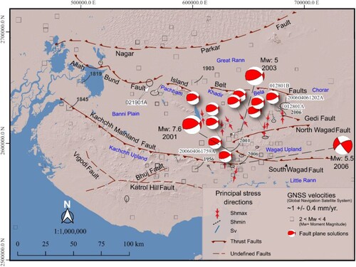
As witnessed in several regions of the world, even in the Kachchh region, the tectonics also controlled the coastal configuration along with the climate (CitationPirrotta et al., 2022; CitationParrino et al., 2022a; CitationParrino et al., 2022b). The 1819 Allah Bund morphogenic seismic event, north of NHR, formed a roughly 90 km long, 6–9 m high fault scarp. The coseismic event deformation caused the cut-off of some rivers from the Arabian sea, the ponding condition north of the scarp, and the sea flooding in the fault southern block (CitationBilham, 1999; CitationMalik et al., 1999a; CitationMalik et al., 1999b; CitationRajendran et al., 2001). A similar influence of the tectonic activity on the coastal configuration, occurred after the 2001 Bhuj Earthquake, which coseismic deformation shifted 5 km north the inundation area of high tides and monsoons (CitationGahalaut and Burgmann, 2004; ).
Figure 1. Seismic events Mw > 5 from 1819 to 2006 with principal stress directions in the Kachchh basin.
Despite these several studies, a detailed characterization of the uplifted deltaic-alluvial fans of the Banni plain and the entire NHR landforms has not yet been produced. To contribute to filling this gap in knowledge and draw a better understanding of the landscape evolution of the coastal landscape of Kachchh, we:
Mapped the coastal landforms of the NHR formed from the interaction between the region's longest active fault, the KMF, and the eustatic SL change.
Reviewed the most relevant papers to draw out a better outline of the landscape evolution of the NHR and its adjacent flat terrain.
2. Geological setting
The geological evolution of the E-W trending Kachchh peri-cratonic basin started in the late Triassic – early Jurassic during the rifting stages of the Gondwana breakup (CitationBiswas, 1987; CitationMerh, 1995). The Indian subcontinent's northward drift started in the late Cretaceous-Early Tertiary, which led to the collision with the Eurasian Plate, causing the uplift of the Himalayan Mountain chain and the tectonic inversion of the Kachchh basin (CitationBiswas, 1982, Citation1987; CitationMerh, 1995). Such positive inversion partially reactivated the pre-existing normal faults flanking the Kachchh basin as thrust faults (CitationBiswas, 1987; CitationKaranth and Gadhavi, 2007; ).
Three different deposits characterize the syntectonic Tertiary deposits outcropping along the flank of the Mesozoic structural highs (see the Lithological Map of Kachchh in the main map): the lower lavas of the Deccan Traps, deposited during the passage of the Indian-subcontinent over the Reunion Hotspot, the middle transgressive marine deposits rich in marine micro and vertebrate fossils (foraminifera, plant fossils, whales, sea cows and fish) and the upper fluvial deposits testifying a general regression (CitationBiswas, 1987; CitationMerh, 1995; CitationJohnston, 1994; CitationBiswas, 2005; CitationCatuneanu and Dave, 2017).
The Kachchh, elongating E-W with an area of more than 45,674 km2 in the western Indian subcontinent, has a diversified landscape, marked by five ca. E-W trending zones: (1) the coastal zone – delimiting the southern of Kachchh, (2) the Uplands – comprising the outcrops of the Mesozoic succession, (3) the quasi flat Banni-Plain, a basin filled with alluvial and mud deposits, with an elevation ranging between 2-12 m (4) the Island belt – an E-W chain of islands viz., Pachham, Khadir, Bela and Chorar, and (5) the saline-waste land that is usually inundated during high tides and Monsoon, namely the Great Rann in the N-NW and the Little Rann in the E, divided by the Wagad topographic high (CitationBiswas, 1987; CitationMalik et al., 2000). Major E-W south or north dipping faults bounds these physiographic units across the basin. The Katrol Hill Fault (KHF) outcrops south of the KU. The E-W striking, S-dipping KMF, separates the KU from the Banni Plain and the Great Rann to the north. The S-dipping Island Belt Fault (IBF) borders to the north the isolated highs of the island belt region. The northern portion of the Kachchh basin is bounded by the N-dipping Allah Bund Fault (ABF). Lastly, the Wagad Upland (WU), located NE of the KU, is supposedly bounded by the North Wagad Fault (NWF) and South Wagad Fault (SWF) along the northern and southern sides, respectively (CitationBiswas, 1987; Biswas, Citation2005; CitationMalik et al., 2017a, Citation2017b; Srivastava et al., Citation2021; https://earthquake.usgs.gov/earthquakes/eventpage/usp000a8ds/executive; )
3. Seismotectonic setting
In the past 500 years, moderate to large magnitudes, historical and instrumental seismicity of the area (6.0 M to 7.8) occurred within the E-W trending faults bounding the Kachchh basin, such as the 1668 Indus-Delta and the 1819 Allah Bund earthquakes (Mw 7.8 and Mw 7.8, respectively) and 1956 Anjar event (Mw 6.0) located near the KHF (Oldham, Citation1883; CitationJohnston and Kanter, 1990; CitationChung and Gao, 1995; Malik et al., Citation2001; CitationBilham et al., 2007; ). CitationSohoni and Malik (1998), based on small-scale folding, micro-faulting, pseudo-sand blow, sand dike, and craters, hypothesized late Quaternary seismic events. Paleoseismological research along the KMF and SWF supports this finding highlighting at least three paleo-earthquakes that may have occurred before 5080 BCE, between 4820 and 2320 BCE, and between BCE 1230 and BCE 04, two of which most likely caused significant harm at the Harappan site (CitationMorino et al., 2008; CitationMalik et al., 2008; CitationMalik et al., 2017a).
The fault plane solutions and the maximum horizontal stress orientations highlight that a general N-S shortening characterizes the whole Kachchh area and that the eastern part is subjected to a roughly NNW-SSE oriented compression (CitationDziewonski et al., 1981; CitationEkström et al., 2012; CitationHeidbach et al., 2019). In the same area, the geomorphic features of the rocky uplands of the Kachchh region suggest a tectonically driven uplifting landscape evolution, such as the faults scarps bounding KU and WU. These features include paired Quaternary fluvial terraces, gorges, truncated paleo-channels, ponding areas, incised alluvial fans, etc. (CitationMalik et al., 2000, Citation2001). According to GNSS data, the ongoing deformation occurs at a rate of 4-5 mm/yr around the faults bounding the basin. The stress map and thrust faults both support that most of this N-S compression is released seismically, with a minor strike-slip component (CitationGahalaut et al., 2019; )
4. Archaeological setting
The archaeological sites of the Kachchh region are considered promising indicators for determining the position, elevation, and age of paleo-shorelines, for the last few thousand years (CitationGaur and Vora, 1999; CitationFlemming, 2004). The Harappan civilization prospered on the edge of the rocky hills and the salt pans of the Rann of Kachchh from 2800–1800 BCE through extensive maritime activity, suggesting that the upland area was navigable (CitationGaur & Vora, 1999; CitationGaur et al., 2013; CitationGiosan et al., 2012; ). The book ‘Periplus of the Erythraean Sea’ (first century CE), describing this area as a shallow marine gulf during Alexander the Great times and reporting seaports along the northern coast of KU till 37 km northwest of the city of Bhuj, now located 50 km from the present coastline, support such indication (CitationBurnes, 1834).
Figure 2. Harrapan archaeological sites and paleo-shoreline in the Holocene period. The dotted black line represents the shoreline proposed by Siveright (1907). The white dotted line represents the CitationGaur and Vora (1999) shoreline deciphered from the positioning of the Harrapan sites during the Middle to Late Holocene. Present-day tidal incursion limits in Kachchh have been derived from the MNDWI indices from LANDSAT-8 data (https://earthexplorer.usgs.gov/.).
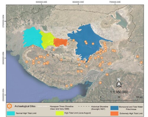
CitationSivewright (1907), based on field observations, proposed that (a) the evolution of the region was controlled by seismic events, such as the 1819 earthquake, which induced a coseismic uplift of about 6 to 9 m in the northern part of Allah Bund and 6m of subsidence to the south, (b) the sea that encircled Kachchh must have entered either from the Kori creek or through the Gulf of Kachchh, (c) the area have been navigable for many hundred years even after the Arab conquest of the area in 712 CE, (d) the former sea gulf was by siltation and progradation of the deltas located eastern of the present day Indus River and by small streams deltas from the KU ().
Harappan sites, located 30–50 km from the present shoreline, host dockyards and stone anchors highlighting the trading activities of these sites (CitationGaur and Vora, 1999; ). This is also supported by the area's high flooding probability, which makes this region unattractive for an agrarian society like the Harappan (CitationGaur et al., 2013). The seismic events datable 2200 BCE, the climate shoreline shifting, and the fluvial siltation of the region led Harappan to leave the Kachchh region (CitationGaur and Vora, 1999).
Archaeoseismological information, such as the seismic events around 2900, 2700, and 2100 BCE, suggest intense tectonic activity during the Harappan times (CitationBisht, 2011). The 2100 BCE event is regarded as the causing factor for the abandonment of early settlements near the KMF that have also experienced damage from events ranging in age from 325 BCE to 2001 CE (CitationSatuluri et al., 2020).
5. Holocene sea-level fluctuations in the study area
The SL curve derived along the coast of W-India describes that around 14,500 years BP, the SL located at –100 m below present-day, followed by a sudden sea level SL rise, at a rate of 10 m/thousand years, up to −80 m around 12,000 yr BP. A still stand with minor fluctuations characterized the period between 12,000 to 10,000 yr BP, followed by an extremely fast rise from −80 m to the present SL from 10,000 to 7,000 yr BP at a rate of 18 mm/year (CitationKale and Rajguru, 1985; CitationHashimi et al., 1995; ).
Figure 3. (a) Locations of the literature study area around the Kachchh basin. (b) Sea level curve of the W-India. Colour-coded triangles show age constraints collected from the literature.
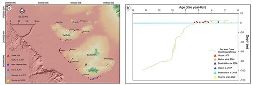
During the Early to Late Holocene, the Kachchh was regarded as a navigable gulf from around 6000 to 2000yr BP, followed by a shallowing to its present level (CitationGaur and Vora, 1999; CitationMalik et al., 1999a; CitationGaur et al., 2013; CitationMakwana et al., 2019; ). The Saurashtra region, south of the Gulf of Kachchh, recorded the highest SL, ranging from 2 to 3 m between 6,500 and 4,500 yr BP (CitationKale and Rajguru, 1985). Geomorphic markers and 14C ages in the same region indicate a SL high up to 4 m in the mid-Holocene, followed by a falling trend (CitationMathur et al., 2004). Mid-Holocene notches at 4–5 m above present SL in the Saurashtra Coast recorded a rapid fall at around 3000 yr BP, contemporary to the flourishing of the Harappan centers from ca. 2800–1800 BCE (CitationTyagi et al., 2012; CitationDas et al., 2017; CitationMakwana et al., 2019) testified by sea notches and wave-cut platforms describing a tectonic uplift of the area up to 2 m of vertical upthrow (CitationBhatt and Bhonde, 2006; CitationPant and Juyal, 1993, please see the to locate the Saurashtra coast).
The mangrove patches north of the central part of KMF in the Banni Plain, proxies for a shallow marine/coastal environment in the area (CitationTripathi et al., 2013), suggest the onset of the late Holocene SL fall started after 3000 BP. At around 1000yr BP SL was estimated at 0.53 ± 0.43 m (CitationSharma et al., 2020).
6. Methods
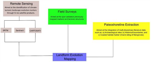
The main map was produced through a remotely sensed geomorphic interpretation of landforms and faults from CARTOSAT-I and Corona satellite products stereo pair with a geometrical resolution of 2.5 and 3 m, respectively. From the forward and afterwards CARTOSAT-I imagery (Indian government web portal, https://bhuvan.nrsc.gov.in/home/index.php), we generated a 3D anaglyphs mosaic following the methodology proposed by CitationEvans et al. (2008) and CitationGianinetto & Fassi (2008). We depicted the topography along NHR using CORONA stereo images (Mission No. 1028-2; Camera No. KH-4A; Date of acquisitions 31-Dec-65) following the methodology proposed by CitationSahoo & Malik (2017), CitationArora et al. (2019). In five years, from 2018-2022, we carried out multiple field surveys to validate the achieved outcome regarding lithological contacts, structures, and landforms.
The location of the Harappan settlements and paleo shorelines were digitized from literature and plotted into a georeferenced environment (CitationSivewright, 1907; CitationGaur and Vora, 1999; CitationGaur et al., 2013; ). Through a literature review, we digitized the Quaternary-Holocene Sea levels along with plotting the collected data locations into a georeferenced environment (CitationGupta, 1972; CitationMathur et al., 2004; CitationBhatt and Bhonde, 2006; CitationDas et al., 2017; CitationMakwana et al., 2019, please see the main map).
To explore the KU relief distribution through swath profiles, we generated a DEM with a geometrical resolution of roughly 15 m, following the methodology proposed by CitationBraun (2021, http://step.esa.int/docs/tutorials/S1TBX%20DEM%20generation%20with%20Sentinel-1%20IW%20Tutorial.pdf). We extracted four swaths: (1) a 10 km width and 156 km long, running parallel to the NHR, and (2) three 5 km width and 25 km long, running across the NHR to the Banni plain. Following the baseline of the first profile, we created a 40 km width swath section sampling instrumental and historical seismic events. The structural pattern was inferred from a literature review and from remotely sensed dataset interpretation, while the stress orientation, fault plane solution, and GNSS data result from catalogues review (CitationEkström et al., 2012; CitationGahalaut et al., 2019; CitationHeidbach et al., 2019; CitationShaikh et al., 2020, Citation2022). To constrain lithological, structural, and geomorphological features, we consulted the published Geological Survey of India Maps at 1:500,000 and the CORONA satellite dataset (CitationDashora et al., 2007).
7. Results
The main features displayed in the here presented main map are:
Lithological contacts deposited since the rifting and formation of the Kachchh basin up to the present (‘Lithological Map of Kachchh’ in the main map).
The main active tectonic faults, striking NW-SE, E-W and NE-SW, are highlighted by fault scarp displacing the Quaternary deposits at the fringe of the KU. Active anticlines along the KMF are the Jhura, Habo, Kaswali and Khirsara.
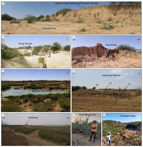
Landforms (), such as (i) V-shaped valleys formed by the downcutting of the rivers in the Mesozoic rocks along their upper reaches across the anticlines and in the Cenozoic deposits near the fold limbs; (ii)series of anticlines and cuesta successions striking NW-SE to E-W forming the NHR.; (iii) different generations of alluvial-deltaic fan surfaces, located at the boundary of the Uplands and the Banni plain-the Great Rann; (iv) several orders of river terraces, incised within the alluvial-deltaic fans; (v) syncline depressions cut in the Mesozoic formations outcropping near the limbs of the anticlinal domes in the western and eastern extremity of NHR, identified using the anaglyphs; (vi) identified/inferred fault traces from high-res satellites datasets and field visit outcropping in the Quaternary-Holocene deposits (please refer the main map).
Figure 4. The methodology was organized as follows: high-resolution satellite mapping, digitization of historical maps and archaeological sites, validation through field surveys, and identification of markers for the evolution of landforms.
We mapped the coastlines ranging from the Harappan settlements periods to the Arab conquest in 712 CE, compiling a georeferenced dataset from bibliographic sources.
The swath profile parallel to the NHR shows four main isolated reliefs, labelled Guneri, Jura, Kas and Khirsara anticlines, respectively, that alternate with low relief areas hosting northward flowing major rivers (profile X-X’ in ). The maximum sampled altitudes vary from 200 to 350 m a.s.l., and the highest relief values characterize the central-eastern portion. Among the NHR perpendicular profiles, the central and eastern profiles show that the escarpments characterized by the most significant relief are also the current cliff. In contrast, the western profile (c) shows incisions north of the prominent escarpment that testifies to a recent uplift of the area after the escarpment formation ((a-c)). The eastern and western profiles show that in the northern ridge, the average elevation (thick black line) approaches the maximum altitudes suggesting recent tectonic activity of these anticlines and a possible control on the local coastal evolution (e.g. CitationCorradino et al., 2021). The western and central profiles show the presence of two external reliefs, characterized by a single frontal relief ((a,b)).
Figure 5. Landforms in the KU. (a) panoramic view of Kaswali river, (b) Knickpoint in the Lothia river, (c) degraded fault scarp near Lodai, (d) syncline depression between the younger anticline domes in the eastern extremity of NHR, (e) multiple terrace levels of Kaila river, (f) hanging pediment near Khari river, (g) depleted mangroves near the toe of the Lodai fan, and (h) small canyon in the Habo dome carved by a seasonal river.
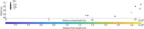
The seismicity catalogues allow the detection of almost absent seismicity in the Kachchh western portion and hypocenters of Mw 4–5 events clustering at about 30 km of depth in the central portion. Hypocenters between 15 and 25 km depth characterize the eastern portion where occurred the most significant event of Mw 6–7 (, Choudhury et al., Citation2016). ()
Figure 6. The transverse and longitudinal swath profiles depicting the topographic relief distribution along and across the NHR.
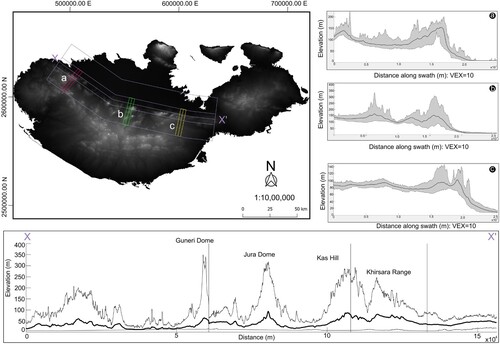
Figure 7. Swath-section, along the X-X’ swath profile shown in , depicting the hypocenters from the revised literature. Circles represent the hypocenters of seismic events in the Kachchh Basin collected in a 40 km width swath and plotted along the cross-section. The colour code represents the distance from the swath baseline, and the circle's size represents the event's magnitude.
8. Discussion and conclusion
The geomorphologic map presented in this work provides, for the first time at the scale of the whole Kachchh basin, information that could improve the knowledge about the reconstruction of its coastal landscape evolution. This basin has witnessed coupled climate and tectonics processes that have forced shoreline migration since the Holocene.
The Banni Plain supports the long-term tectonic forcing on the landscape evolution of the Kachchh region. The different levels of deltaic-alluvial fans, their associated incised Quaternary-Holocene river terraces, the valleys that fed the sediments, and the identified/inferred faults in quaternary alluvial sediments (in the Main map and (a)) are such landforms that testifies to the persistence of low gradients since the Late Quaternary, which made the Banni Plain prone to tectonics and climatic events. The long list of seismic events and SL fluctuations since the Holocene, along with the previous deltaic environment, must have played a significant role in the drastic changes in the coastal landscape from being once the arm of the Arabian sea to the present raised fluvio-intertidal environment (CitationSohoni & Malik, 1998; CitationMorino et al., 2008; CitationMalik et al., 1999b, Citation2000). The SL fluctuations describe a high-water stand ranging between 2 to 4 m till 6000 BP and a sea level falling trend since then (CitationMathur et al., 2004; CitationBhatt and Bhonde, 2006; CitationTyagi et al., 2012; CitationDas et al., 2017; CitationMakwana et al., 2019).
Climate and tectonic perturbations on the coastal landscape evolution significantly influenced the Harappan civilization, making the maritime Harappan settlements an interesting SL proxy as this area has been known as non-cultivable land since prehistoric times. The Harappans were an agrarian society; that is why the question arises regarding the reasons for settlement (CitationGaur and Vora, 1999; CitationGiosan et al., 2012; CitationGaur et al., 2013; ). The dockyards and stone anchors proved them as maritime trading centers. The other archaeological sites located in the Rann, if compared with the present major towns such as Gandhidham, Mandvi and Bhuj, are far away from the Gulf of Kachchh.
We believe that the review and map made in this paper of geomorphological, paleoseismological, tectonic, and archaeological studies may serve as starting documentation for future research in the field of active tectonics and paleoseismology, geochemical and sedimentological studies and modulation of overall possible landscape evolution models of Kachchh basin.
Software
The DEM and anaglyph from CARTOSAT-I were produced by ENVI, while the DEM data from the Sentinel-1 dataset was extracted through SNAP. Morphometric analyses, general processing, and the extraction of swath profiles were performed using QGIS 3.24-Tisler, MATLAB, and TopoToolbox (CitationSchwanghart & Scherler, 2014), respectively. The vector-based creation of the Map was done using Inkscape.
Supplemental Material
Download Zip (133.6 MB)Acknowledgements
This study was conducted as part of the Landscape Evolution Marker Online Network (LEMON) project, a multi-year initiative co-funded by the scientific associations INQUA and AIQUA. Financial support provided by the Ministry of Earth Sciences (Seismology Division), New Delhi [Grant No. MoES/PO(Seismo)/1(270)/AFM/2015] to JNM and MSG is duly acknowledged. We sincerely thank Dr Shreya Arora, Mitthu Dhali, Prabhat Kumar, Dr Fousiya AA for providing support in the field and lab, the special issue editors, and the reviewers for their suggestions which highly improved the quality of both research paper and main map.
Disclosure statement
No potential conflict of interest was reported by the author(s).
Additional information
Funding
References
- Arora, S., Malik, J. N., & Sahoo, S. (2019). Tectonophysics Paleoseismic evidence of a major earthquake event (s) along the hinterland faults : Pinjore Garden Fault (PGF) and Jhajra Fault (JF) in northwest. Tectonophysics, 757(January), 108–122. https://doi.org/10.1016/j.tecto.2019.01.001
- Bhatt, N., & Bhonde, U. (2006). Geomorphic expression of late Quaternary sea level changes along the southern Saurashtra coast, western India. 4, 395–402.
- Bilham, R., Lodi, S., Hough, S., Bukhary, S., Khan, A. M., & Rafeeqi, S. F. A. (2007). Seismic hazard in Karachi, Pakistan: Uncertain past, uncertain future. Seismological Research Letters, 78, 601–613.
- Bilham, Roger. (1999). Slip parameters for the Rann of Kachchh, India, 16 June 1819, earthquake, quantified from contemporary accounts. Geological Society, London, Special Publications, 146(1), 295–319. https://doi.org/10.1144/GSL.SP.1999.146.01.18
- Bisht, R. S. (2011). Major earthquake occurrences in archaeological strata of Harappan settlement at Dholavira (Kachchh, Gujarat) (abstract). In: International Symposium on the 2001 Bhuj Earthquake and Advances in Earthquake Science (AES-2011), Gandhinagar, 22-24 January.
- Biswas, S K. (1982). Rift basins in western margin of India and their hydrocarbon prospects with special reference to Kutch basin. AAPG Bulletin, 66(10), 1497–1513.
- Biswas, S. K. (1987). Regional Tectonic Framework, Structure and Evolution ofthe Western Marginal Basins of India. Tectonophysics, 135, 307–327. doi:10.1016/0040-1951(87)90115-6
- Biswas, S K. (2005). A review of structure and tectonics of Kutch basin, western India, with special reference to earthquakes. Curr. Sci, 88(10), 1592–1600.
- Braun, A. (2021). DEM generation with Sentinel-1 Workflow and challenges. SkyWatch Space Applications Inc.: Waterloo, ON, Canada.
- Burnes, A. (1834). Memoir on the eastern branch of the River Indus, giving an account of the alterations produced on it by an earthquake, also a theory of the formation of the runn, and some conjectures on the route of alexander the great; drawn up in the years 1827-1828. Transactions of the Royal Asiatic Society of Great Britain and Ireland, 3, 550–588.
- Catuneanu, O., & Dave, A. (2017). Cenozoic sequence stratigraphy of the Kachchh Basin, India. Marine and Petroleum Geology, 86, 1106–1132. https://doi.org/10.1016/j.marpetgeo.2017.07.020
- Choudhury, P. A. L. L. A. B. E. E., & Kumar, M. R. (2016). The Institute of Seismological Research—A premier research center for seismology in India. In Proc. Ind. Natl. Sci. Acad. (No. 3, pp. 1049-1060).
- Chung, W. Y., & Gao, H. (1995). Source parameters of the Anjar earthquake of July 21, 1956, India, and its seismotectonic implications for the Kutch rift basin. Tectonophysics, 242(3–4), 281–292. https://doi.org/10.1016/0040-1951(94)00203-L
- Cleuziou, S., & Tosi, M. (1993). Black boats of Magan: Some thoughts on Bronze Age water transport in Oman and beyond from the impressed bitumen slabs of Ra's al-Junayz. Annales Academiae Scientiarum Fennicae. Series B, 273, 745–761.
- Corradino, M., Pepe, F., Burrato, P., Kanari, M., Parrino, N., Bertotti, G., … Tibor, G. (2021). An integrated multiscale method for the characterisation of active faults in offshore areas. The Case of Sant'Eufemia Gulf (Offshore Calabria, Italy). Frontiers in earth science, 9, 476.
- Das, A., Prizomwala, S., Makwana, N., & Thakkar, M. (2017). Late Pleistocene-Holocene climate and sea level changes inferred 1 based on the tidal terrace sequence, Kachchh, Western India. Palaeogeography, Palaeoclimatology. Palaeoecology, 473, 82–93.
- Dashora, A., Lohani, B., & Malik, J. N. (2007). A repository of earth resource information – CORONA satellite programme. Current Science, 92(7).
- Dziewonski, A. M., Chou, T.-A., & Woodhouse, J. H. (1981). Determination of earthquake source parameters from waveform data for studies of global and regional seismicity. J. Geophys. Res, 86, 2825–2852. doi:10.1029/JB086iB04p02825
- Ekström, G., Nettles, M., & Dziewonski, A. M. (2012). The global CMT project 2004-2010: Centroid-moment tensors for 13,017 earthquakes. Phys. Earth Planet. Inter, 200-201, 1–9. doi:10.1016/j.pepi.2012.04.002
- Evans, G. A., Ramachandran, B., Zhang, Z., Bailey, B. G., & Cheng, P. (2008). An Accuracy Assessment of Cartosat-1 Stereo Image Data-Derived Digital Elevation Models: A Case Study of the Drum Mountains, Utah. The International Archives of the Photogrammetry, Remote Sensing and Spatial Information Sciences, 37, B1. http://www.usgsquads.com/prod_doqq.htm (U.S. coverage).
- Flemming, N. (2004). Submarine prehistoric archaeology of the Indian continental shelf: A potential resource. Current Science, 86(9), 1225–1230.
- Gahalaut, V. K., & Bürgmann, R. (2004). Constraints on the source parameters of the 26 January 2001 Bhuj, India, earthquake from satellite images. Bulletin of the Seismological Society of America, 94(6), 2407–2413. https://doi.org/10.1785/0120040021
- Gahalaut, V. K., Gahalaut, K., Dumka, R. K., Chaudhury, P., & Yadav, R. K. (2019). Geodetic evidence of high compression across seismically active Kachchh Paleorift, India. Tectonics, 38(8), 3097–3107. https://doi.org/10.1029/2019TC005496
- Gaur, A. S., & Vora, K. H. (1999). Ancient shorelines of Gujarat, India, during the Indus civilization (late mid-holocene): A study based on archaeological evidences. Current Science, 77(1), 180–185. https://doi.org/10.1021/es402676n
- Gaur, A. S., Vora, K. H., Sundaresh, Mani Murali, R., & Jayakumar, S. (2013). Was the Rann of kachchh navigable during the harappan times (mid-holocene)? An archaeological perspective. Current Science, 105(11), 1485–1491.
- Gianinetto, M., & Fassi, F. (2008). Validation of CARTOSAT-1 DTM generation for the salon de provence test site. The International Archives of the Photogrammetry, Remote Sensing and Spatial Information Sciences, 37, B1.
- Giosan, L., Clift, P., Macklin, M., Fuller, D., Constantinescu, S., Durcan, J., Stevens, T., Duller, G., Tabrez, A., Gangal, K., Adhikari, R., Alizai, A., Filip, F., Vanlaningham, S., & Syvitski, J. (2012). Fluvial landscape of the Harappan civilization. PNAS E, 109(26), E1688–E1694. https://doi.org/10.1073/pnas.1112743109
- Gupta, S. K. (1972). Chronology of the raised beaches and inland coral reefs of the Saurashtra coast. Journal of Geology, 18(3), 357–361.
- Gupta, S. K. (1975). Silting of the Rann of the Kutch during the Holocene. Indian J. Earth Sci, 2, 163–175.
- Hashimi, N. H., Nigam, R., Nair, R. R., & Rajagopalan, G. (1995). Holocene sea level fluc- tuations on western Indian continental margin: An update. Journal of the Geological Society of India, 46, 157–162.
- Heidbach, O., Rajabi, M., Reiter, K., & Ziegler, M. (2019). World stress map. In Encyclopedia of petroleum geoscience (pp. 1–8). Springer.
- Johnston, A C, Coppersmith, K J, & Kanter, L R. (1994). Report TR (Vol. 10261, pp. 20–40). Electric Power and Research Institute.
- Johnston, A. C., & Kanter, L. R. (1990). Earthquakes in stable continental crust. Sci. Am, 262, 69–75.
- Kale, V. S., & Rajguru, S. N. (1985). Neogene and quaternary transgressional and regressional history of the west coast of India: An overview. Bulletin Deccan College, Research Institute, 44, 153–165.
- Karanth, R. V., & Gadhavi, M. S. (2007). Structural intricacies: Emergent thrusts and blind thrusts of central Kachchh, western India. Current Science, 93, 1271–1280.
- Kenoyer, J. M. (2003). Recently Excavated Artifacts from Pakistan Have Inspired a Reevaluation of One of the Great Early Urban Cultures—the Enigmatic Indus Valley Civilization: Undiscovering the Keys to Lost Indus Cities), vol. 289. Scientific American, Inc., pp. 68–75 1.
- Makwana, N., Prizomwala, S. P., Chauhan, G., Phartiyal, B., & Thakkar, M. G. (2019). Late Holocene palaeo-environmental change in the Banni Plains, Kachchh, Western India. 507(January 2018), 197–205.
- Makwana, N., Prizomwala, S. P., Das, A., Phartiyal, B., & Sodhi, A. (2021). Reconstructing the Climate Variability During the Last 5000 Years From the. 9(July), 1–11. https://doi.org/10.3389/feart.2021.679689.
- Malik, J. N., Gadhavi, M. S., Kothyari, G. C., & Satuluri, S. (2017a). Paleo-earthquake signatures from the South Wagad Fault (SWF), Wagad Island, Kachchh, Gujarat, western India: A potential seismic hazard. Journal of Structural Geology, 95, 142–159. https://doi.org/10.1016/j.jsg.2016.12.011
- Malik, J. N., Merh, S. S., & Sridhar, V. (1999b). Paleo-delta complex of Vedic Sarasvati and other ancient rivers of northwestern India. Memoir Geological Society of India, 163–174.
- Malik, J. N., Morino, M., Mishra, P., Bhuiyan, C., & Kaneko, F. (2008). First active fault exposure identified along Kachchh Mainland Fault: Evidence from trench excavation near Lodai village, Gujarat, Western India. Journal of the Geological Society of India, 71, 201–208.
- Malik, J. N., Naik, S. P., Sahoo, S., Okumura, K., & Mohanty, A. (2017b). Tectonophysics Paleoseismic evidence of the CE 1505 (?) and CE 1803 earthquakes from the foothill zone of the Kumaon Himalaya along the Himalayan Frontal Thrust (HFT), India. Tectonophysics, 714–715, 133–145. https://doi.org/10.1016/j.tecto.2016.07.026
- Malik, J. N., Sohoni, P. S., Karanth, R. V., & Merh, S. S. (1999a). Modern and historic seismicity of Kachchh peninsula, western India. J. Geol. Soc. India 54.
- Malik, J. N., Sohoni, P. S., Merh, S. S., & Karanth, R. V. (2000). Palaeoseismology and neotectonism of Kachchh, western India. In: Okumura, K., Takada, K., Goto, H. (Eds.), Proceedings of the Hokudan International Symposium and School on Active Faulting, Japan.
- Malik, J. N., Sohoni, P. S., Merh, S. S., & Karanth, R. V. (2001). Active tectonic control on alluvial fan architecture along the Kachchh Mainland hill range, western India. Zeithschrift für Geomorphol, 45(1), 81–100.
- Mathur, U. B., Pandey, D. K., & Bahadur, T. (2004). Falling late Holocene sea-level along Indian coast. Current Science, 87, 439–440.
- Merh, S. S. (1995). Geology of Gujarat. J. Geol. Soc. India 222.
- Morino, M., Malik, J. N., Mishra, P., Bhuiyan, C., & Kaneko, F. (2008). Active fault traces along Bhuj Fault and Katrol Hill fault, and Trenching survey at Wandhay, Kachchh, Gujarat, India. Journal of Earth System Science, 117(3), 181–188. https://doi.org/10.1007/s12040-008-0022-1
- Oldham, T. (1883). A Catalogue of Indian Earthquakes from the Earliest Times to the End of 1869 A.D. Memoirs of Geological Survey of India. XIX, Part. 3.
- Pant, R. K., & Juyal, N. (1993). Late Quaternary coastal instability and sea level changes: New evidences from Saurashtra coast, Western India. Zeitschirft f¨ur Geomorphologie, 37, 29–40.
- Parrino, N., Burrato, P., Sulli, A., Gasparo Morticelli, M., Agate, M., Srivastava, E., Malik, J. N., & Di Maggio, C. (2022a). Plio-Quaternary coastal landscape evolution of north-western Sicily (Italy). Journal of Maps, https://doi.org/10.1080/17445647.2022.2159889
- Parrino, N., Pepe, F., Burrato, P., Dardanelli, G., Corradino, M., Pipitone, C., Gasparo Morticelli, M., Sulli, A., & Di Maggio, C. (2022b). Elusive active faults in a low strain rate region (Sicily, Italy): Hints from a multidisciplinary land-to-sea approach. Tectonophysics, 839, 229520. https://doi.org/10.1016/j.tecto.2022.229520
- Pillai, A. A. S., Anoop, A., Prasad, V., Manoj, M. C., Varghese, S., Sankaran, M., & Ratnam, J. (2018). Multi-proxy evidence for an arid shift in the climate and vegetation of the Banni grasslands of western India during the mid- to late-Holocene. https://doi.org/10.1177/0959683618761540.
- Pillai, A. A. S., Anoop, A., Sankaran, M., Sanyal, P., Jha, D. K., & Ratnam, J. (2017). Mid-late Holocene vegetation response to climatic drivers and biotic disturbances in the Banni grasslands of western India. Palaeogeography, Palaeoclimatology, Palaeoecology, 485, 869–878. https://doi.org/10.1016/j.palaeo.2017.07.036
- Pirrotta, C., Parrino, N., Pepe, F., Tansi, C., & Monaco, C. (2022). Geomorphological and morphometric analyses of the catanzaro trough (Central Calabrian Arc, Southern Italy): Seismotectonic implications. Geosciences, 12(9), 324. https://doi.org/10.3390/geosciences12090324
- Possehl, G. (2002). The indus civilization: A contemporary perspective. Altamira Press.
- Rajendran, C. P. (2001). Characteristics of Deformation and Past Seismicity Associated with the 1819 Kutch Earthquake, Northwestern India. Bulletin of the Seismological Society of America, 91(3), 407–426. https://doi.org/10.1785/0119990162
- Sahoo, S., & Malik, J. N. (2017). Active fault topography along Kangra Valley Fault in the epicentral zone of 1905 Mw7 .8 earthquake NW Himalaya, India. Quaternary International, 462, 90–108. https://doi.org/10.1016/j.quaint.2017.03.020
- Satuluri, S., Gadhavi, M. S., Malik, J. N., & Vikrama, B. (2020). Quantifying seismic induced damage at ancient site Manjal located in Kachchh Mainland region of Gujarat, India. Journal of Archaeological Science: Reports, 33(September 2019), 102486. https://doi.org/10.1016/j.jasrep.2020.102486
- Schwanghart, W., & Scherler, D. (2014). TopoToolbox 2–MATLAB-based software for topographic analysis and modeling in Earth surface sciences. Earth Surface Dynamics, 2(1), 1–7.
- Shaikh, M. A., Maurya, D. M., Mukherjee, S., Vanik, N. P., Padmalal, A., & Chamyal, L. S. (2020). Tectonic evolution of the intra-uplift Vigodi-Gugriana-Khirasra-Netra Fault System in the seismically active Kachchh rift basin, India : Implications for the western continental margin of the Indian plate. Journal of Structural Geology, 140(November 2019), 104124. https://doi.org/10.1016/j.jsg.2020.104124.
- Shaikh, M. A., Patidar, A. K., Maurya, D. M., Vanik, N. P., Padmalal, A., Tiwari, P., … Chamyal, L. S. (2022). Building tectonic framework of a blind active fault zone using field and ground-penetrating radar data. Journal of Structural Geology, 155, 104526.
- Sharma, S., Chauhan, G., Shukla, A. D., Nambiar, R., Bhushan, R., Desai, B. G., Pandey, S., Dabhi, M., Bhandari, S., Bhosale, S., Lakhote, A., & Juyal, N. (2020). Causes and implications of Mid- to Late Holocene relative sea-level change in the Gulf of Kachchh, western India. February, 2021), https://doi.org/10.1017/qua.2020.86
- Sivewright, R. (1907). Cutch and the Ran. The Geographical Journal, 29, 518–535.
- Sohoni, P., & Malik, J. N. (1998). Remnants of large magnitude earthquakes: Evidences from the Great Rann sediments, Kachchh, Western India. Current. Science, 74(11), 985–989.
- Srivastava, E., Parrino, N., Malik, J., Pepe, F., & Burrato, P. (2021). Looking for the hidden morphological signature of active faults in a Low Strain Rate region: clues from the eastern Kachchh region (NW India). In EGU General Assembly Conference Abstracts (pp. EGU21-15982).
- Tripathi, N., Singh, R. S., Parmar, D., & Mishra, B. K. (2013). The world's only inland mangrove in sacred grove of Kachchh, India, is at risk. Current Science, 105(8), 1053–1055.
- Tyagi, A. K., Shukla, A. D., Bhushan, R., Thakker, P. S., Thakkar, M. G., & Juyal, N. (2012). Geomorphology Mid-Holocene sedimentation and landscape evolution in the western Great Rann of Kachchh, India. Geomorphology, 151–152, 89–98. https://doi.org/10.1016/j.geomorph.2012.01.018