
ABSTRACT
This paper presents a 1:20,000 scale Geoarchaeological map of the Cornia river coastal plain in southern Tuscany. The Geoarchaeological map integrates a comprehensive dataset of geomorphological and archaeological features. The spatial relationships between landforms and archaeological records show that the settlement pattern from the VII century BC to the V century AD was mostly influenced by the presence of several depositional landforms which formed before the period under consideration. Integrating the outputs of geomorphological and topographical analyses with archaeological databases is also helpful for land planning, especially in areas where present-day anthropic exploitation needs predictive and valid tools to assess the archaeological hazard.
Highlights
The integration between geomorphology and archaeology has provided new insights for the study of the evolution of the Cornia river coastal landscape.
Geoarchaeological map was fundamental to disentangle the complexity of the coastal plain, which evolution is linked to complex environmental-anthropic dynamics and recent heavy reclamation activities.
Human settlement strategies in wet-dominated landscapes typical of these sectors of the Tuscany coasts are strongly influenced by geomorphological processes in terms of landforms and related hazards.
1. Introduction
Human occupation of Mediterranean coastal areas reaches back to prehistoric times, as they lie in the landscape between the inland and the sea (CitationMarriner et al., 2014). At the mouths of major rivers, coastal landscapes are often characterised by wide alluvial/coastal plains. Despite the limited length of many Mediterranean rivers, alluvial coastal plains formed during the Holocene were occupied by wetlands, whose characteristics were the result of complex interactions between natural and anthropic processes, including sea-level rise, fluvial aggradation, slope erosion, tectonics, climate change, and adaptation/reclamation by human communities (CitationBuonincontri et al., 2020; CitationFletcher & Zielhofer, 2013; CitationGiorgi & Lionello, 2008; CitationGrove & Rackham, 2003; CitationHaldon et al., 2014; CitationLambeck & Purcell, 2005; CitationLavorel et al., 1998; CitationLuterbacher et al., 2006; CitationManning, 2013; CitationMattei et al., 2022; CitationMcCormick et al., 2012; CitationPieruccini et al., 2021; CitationRoberts et al., 2004; CitationVacchi et al., 2016).
Holocene lagoons and swampy floodplains, nowadays mostly reclaimed, are typical of several sectors of the Tyrrhenian Sea coasts (CitationBellotti et al., 2004; CitationCurrás et al., 2017; CitationDi Rita et al., 2010; CitationMariotti Lippi et al., 2007; CitationMelis et al., 2018; CitationRossi et al., 2011; CitationRuello et al., 2017; CitationSacchi et al., 2014; CitationVittori et al., 2015) and constitute a unique proxy record for understanding their local evolution in time and space and the framework of the Mediterranean basin. These wet landscapes persisted through historical times, and their definitive reclamation, in most cases, occurred during the last centuries. Nevertheless, several attempts at reclamation have also been recorded in the last 1–2 millennia (CitationRossi-Doria & Bevilacqua, 1984).
Thus, coastal deposits and related geomorphic features are natural archives for disentangling the landscape evolution across prehistoric and historical times, allowing the multidisciplinary reconstruction of the environmental variables (CitationMorellón et al., 2016). Moreover, understanding past interactions between natural and anthropic forces is a key topic for planning proper management of coastal areas, including the preservation and valorisation of the cultural and historical heritage (CitationCataudella et al., 2015).
This paper presents the Late Holocene Geoarchaeological map at 1:20,000 scale of the Cornia river coastal plain (southern Tuscany, Italy), using geomorphological and archaeological records in a multidisciplinary approach to understand the relationships between human settlement patterns and natural processes at the sea/land interface.
2. Geographical, geomorphological and archaeological setting
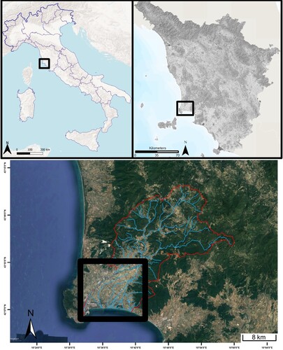
The Cornia river coastal plain is located in southern Tuscany, east of the town of Piombino (). The coastal plain opens at ca. 11 km from the present-day coastline with a width of about 10 km and a mean slope of about 0,7% (CitationPieruccini & Susini, 2020). The Cornia river, the main perennial watercourse of the coastal plain, is approximately 50 km long, whilst its drainage basin covers about 350 km2.
Figure 1. Location of the Cornia river coastal plain.
The coastal plain consists of alluvial/coastal sedimentary successions up to 100 m thick (CitationBarazzuoli et al., 1999; CitationCensini et al., 1991; CitationGhezzi et al., 1993) deposited during the late Quaternary climatic and eustatic oscillations. The interaction with tectonic uplift movements is evident from the patchy deposits of the Last Interglacial occurring along the Tuscan coast (CitationBenjamin et al., 2017; CitationCerrone et al., 2021; CitationMazzanti et al., 1981). The source of the fluvial sediments are Triassic-Miocene sedimentary rocks of the carbonatic systems and the siliclastic foreland basins, which belong to the Non-Metamorphic Tuscany successions (CitationConti et al., 2020 and references therein). Moreover, limited outcrops of continental Late Miocene conglomerates and marine clayey Pliocene unconsolidated sediments are also present.
According to historical sources and maps, open lagoons and inner swamps have existed in this area throughout historical times. However, the present-day surface hydrology consists of a network of artificial channels following the reclamation works, which concluded in the first half of the XX century (CitationLondi et al., 2007). Thus, most of the sedimentary load is captured for the infilling of the low-lying coastal lagoon and the present-day coastline dynamics are strongly affected by erosional processes.
Human frequentation within the coastal plain has been attested since the Neolithic (CitationFedeli, 1983). Few Late Bronze Age settlements are documented on the older coastal dunes, whereas from the Orientalising period (mid. VII century BC) scattered habitations with agricultural purposes became more frequent within the central part of the plain (CitationGiroldini, 2010). During the Archaic and Classical periods (VI-V centuries BC), rural settlement patterns in this part of the coastal plain remained unaltered, despite the flourishing metallurgical activities along the western coast (CitationCambi, 2009).
Towards the end of the IV century BC, when the territory passed under the influence of the Roman Republic, the number of settlements across the coastal plain increased drastically. Besides the colonisation of new locations, many earlier long-lasting settlements continued to be occupied until the Early Roman Empire (II century AD). At the end of the Republican period (I century BC), few small farmsteads evolved into villas, leading to the rarefaction of scattered settlements and the establishment of latifundia (CitationCambi, 2009). During the III century AD (Late Roman Empire), the crisis of this agricultural system led to the abandonment of many long-lasting settlements. A similar crisis occurred in other parts of the Tyrrhenian coast (CitationMarzano, 2007). Comparatively, few sites survived in the coastal plain until the Late Antiquity (VI-VII centuries AD), possibly related to the proximity to main roads (CitationPonta, 2019).
3. Materials and methods
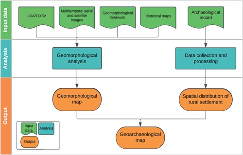
Geomorphological analysis and evaluation of cartographic sources were performed to reconstruct the morpho-evolution of the Cornia river coastal plain within the Late Holocene. The spatial distribution of the archaeological evidence was analysed in order to infer the settlement patterns and their dynamics related to the presence of specific landforms. The process is summarised in .
Figure 2. Methodological workflow of the geoarchaeological study.
3.1. Field and remote geomorphological analysis
The geomorphological field survey and mapping was carried at the 1:10,000 scale using the available Tuscany Region topo-maps (http://www.regione.toscana.it/web/geoblog/-/open-geodata). Geomorphological features were classified following the legend derived from the Italian National Geological Survey guidelines for the 1:50,000 scale Geomorphological Map of Italy (CitationISPRA, 2018; CitationISPRA-APAT, 1994). Artificial sections were also described for stratigraphic and related sedimentological characteristics. The geomorphological spatial database is structured with 2 layers (polygons and lines), which contain the values of the attributes related to the type of landforms, their morphogenetic origin and their re-classification according to the main purposes of the map.
Due to the very low-energy relief of the coastal plain, many landforms were not directly recognisable in the field. For this reason, the geomorphological analysis was conducted using remote-sense data, specifically a LiDAR-derived DTM with 1 m resolution and vertical and horizontal accuracy, namely less than 15 and 30 cm (MATTM – ‘Ministero dell’Ambiente e Della Tutela del Territorio e del Mare’). DTM histogram stretching improved the detection of small variations in elevation values by adjusting the thresholds to specific portions of the coastal plain. The DTM was also processed to determine the Topographic Position Index (TPI). This algorithm compares the elevation value of each cell with the average elevation value of the surrounding cells (CitationSeif & Ebrahimi, 2014). TPI was calculated in SAGA GIS, setting the neighbour radius to 600 m after a trial-and-error approach ().
Figure 3. Remote geomorphological analysis conducted on LiDAR DTM: 3a) DTM histogram stretch; 3b) TPI raster.
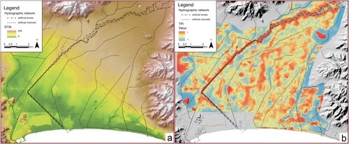
Thus, positive values indicate high-elevated landforms, whilst negative values indicate low-elevated landforms. Their extent was highlighted by downscaling the DTM to 20 m, which enhanced the resolution of more significant features and reduced the noise background of artificial elements (e.g. field channelling, ploughing).
The landforms associated with the palaeo-drainage network were observed from a set of B/W and colour multitemporal aerial images acquired from: ‘Istituto Geografico Militare’ (IGM flight 1938; scale 1:16,000); GAI flight (1954; scale 1:30,000); Toscana Region flights (1978, 1988; scale 1:13,000); panchromatic orthophoto (1996; resolution 1 m); RBG orthophotos (2007, 2010, 2013; resolution 0,5 m); RGB + NIR orthophotos (2016, 2019; resolution 0,2 m); and aerial and satellite images from Google Earth (2016–2019; resolution approximately 0,2 m). All remote images and digital models are available from the Regione Toscana Environmental Agency (http://www.regione.toscana.it/web/geoblog/-/open-geodata).
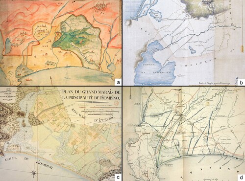
Historical maps (Progetto CASTORE, Regione Toscana e Archivi di Stato Toscani https://www.regione.toscana.it/-/castore) were employed to compare the evolution of the fluvial network and the extensions of the lagoonal and swampy environments before the reclamation that took place after the XVI century AD. These historical maps are (): ‘Carta del Golfo di Piombino e Follonica tra Granducato di Toscana e Principato di Piombino’ (half XVI century AD); ‘Pianta del piano di campiglia’ (1779); ‘Plan du Grand Maraìs de la Princip Autè de Piombino’ (1807); ‘Pianura di Cornia prima delle Bonificazioni’ (1830).
Figure 4. Selection of the most informative historical maps examined to reconstruct the evolution of the fluvial system, the lagoon extension and the reclamation activities that occurred in the Modern Age (maps not in scale). 4a) ‘Carta del Golfo di Piombino e Follonica tra Granducato di Toscana e Principato di Piombino’, half XVI century AD; 4b) ‘Pianta del piano di campiglia’, 1779; 4c) ‘Plan du Grand Maraìs de la Princip Autè de Piombino’, 1807; 4d) ‘Pianura di Cornia prima delle Bonificazioni, 1830’. Progetto CASTORE https://www.regione.toscana.it/-/castore
3.2. Archaeological database
For this paper, existing archaeological databases from previous research projects were merged, processed and normalised into a single extensive database. (CitationBotarelli & Cambi, 2005; CitationDallai, 2016; CitationFedeli, 1983; CitationGiroldini, 2010, Citation2012; CitationPonta, 2019). The analysis was mostly carried out with extensive field survey covering approximately 78% of the total extension of agricultural areas of the coastal plain (about 4000 hectares in total). The centroids of material concentration were measured with hand-held GNSS systems (metric accuracy) and the locations with attribute information were stored in a spatial database. From the whole dataset, only records pertaining to ancient rural settlements were selected and grouped into five main categories: habitation sites (including farmhouses); productive metallurgic sites; burial sites; Roman villas (from the I century BC); and off-site frequentations. Four periods were assessed based on the available data (i.e. only a few sites are recorded for the Neolithic and Bronze Age) and the main social and economic changes. These four periods are: Period1 (mid. VII-V century BC); Period2 (IV-II century BC); Period3 (I century BC-II century AD); and Period4 (III-V century AD).
For this study, only published records were considered, whilst the remaining records were lowered in reliability rank and used to verify the correctness of the proposed model. Concerning the accuracy and consistency of the archaeological record, it must be taken into account that in this geomorphological context, fluvial dynamics, runoff processes, land-use changes, and reclamation activities played a significant role in the preservation and conservation of the archaeological evidence due to the related erosional and depositional processes. Nevertheless, the available archaeological dataset shows repeated patterns of settlement distribution across the plain. Thus, the archaeological record provides a minimum age for modelling the depositional landforms. Indeed, the chronology of their deposition is problematic, as the paucity of geochronological data indicate how some of these landforms formed from the VI millennium BC up to the VI century AD (CitationPieruccini & Susini, 2020).
4. Results
The overall geomorphological setting of the area allows its subdivisions into three major Landscape Units (Hills, Coastal Plain, Coast), which are in turn subdivided into Landscape Elements characterised by peculiar geomorphic, sedimentary processes and the occurrence of specific landforms (CitationChristian, 1958; CitationZonneveld, 1989). These are distinguished primarily according to their topographic position, resulting in two groups of high- and low-elevated areas with respect to their local neighbourhood.
The geoarchaeological map focuses on the alluvial and coastal plain of the Cornia river. For this reason, this study does not include hills, slopes, and terraces in the western part of the plain. The archaeological record within the selected area includes 164 unique sites, subdivided into 87 habitation sites, 5 productive metallurgical sites, 11 burial sites, 6 Roman villas, and 55 off-site frequentations.
4.1. Landscape unit hill
4.1.1. RE – reliefs
The relief of the Cornia coastal area is characterised by gentle to steep and often stepped slopes (a), mainly controlled by selective erosion on the bedrock. The hydrographic network is mostly dendritic, whilst the slopes are mainly convex or undulated due to runoff and shallow to deep gravitational processes and affected by strong soil erosion processes triggered primarily by land-use practices.
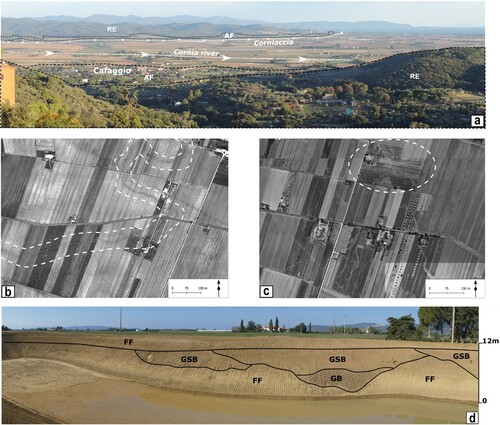
Figure 5. Geomorphological features. 5a) West-view of the Cornia coastal plain. The Landscape elements, such as fluvial ridges (FR) and crevasse splays (CS) are not represented due to their very limited relief; 5b) B/W 1978 aerial photo of the ‘Franciana Ridge’, the dashed white lines highlight one of the darker sinuous palaeochannel, typically observable on top of the fluvial ridges (FR); 5c) B/W 1978 aerial photo of the ‘Vignarca Crevasse Splay’, the dashed white circle highlights one of the dense network of divergent palaeochannels typically observed on top of crevasse splays (CS); 5d) The artificial cut, close to ‘Panconcello’, excavated for irrigation water basin within the Corniaccia Floodplain (CF). The outcrop shows the presence of deep channels filled with Gravelly Bedforms (GB) and Sandy-Gravelly Bedforms (GSB) cut into and buried by Overbank Fines (FF) silts and clays.
4.1.2. AF – alluvial fans
Most of the footslopes at the transition to the alluvial and coastal plain are characterised by almost continuous coalescent inactive, gently dipping alluvial fans. These are frequently terraced as they were re-incised by the drainage network after deposition, whereas the present-day drainage is artificially regulated (a). This landscape element was settled since Period1 (mid. VII-V century BC) in the south-eastern sector (Vignale and Riotorto), whilst in the northern sector (Cafaggio and Venturina) habitation sites have been known since Period2 (IV-II century BC). The long-lasting occupation of these landscape elements is probably due to the elevation of the alluvial fans over the lower-lying coastal plain, suggesting low geomorphological hazards and the stability of the surfaces. This stability is also evidenced by the evolution of the settlements of Cafaggio and Vignale into Roman villas during Period3 (I century BC – II century AD).
4.2. Landscape unit coastal plain
4.2.1. AT – alluvial terraces
Alluvial terraces are the oldest evidence of former alluvial plains, possibly dating to the Late Pleistocene and related marine low-stands (CitationAmorosi et al., 2004; CitationPieruccini et al., 2021). The only remnants of these features are found at Casalappi (a), an isolated flat surface hanging ca. 20 m over the surrounding floodplain where Middle Palaeolithic industry has also been reported (CitationGaliberti, 1970). The presence of a Middle-Age castle on top of the terrace may have prevented the conservation of older settlements.
4.2.2. FR – fluvial ridges
They are elongated, sinuous, high-elevated features elevated up to 2 m over the surrounding topography. The largest ridge, more than 6 km long in the north–south axis and up to 1,2 km wide, is found in the Franciana area, in the central part of the coastal plain. On the other hand, narrower ridges, up to 3 km long, are found across the whole area (e.g. Pescinone, Poggiali, P. Piombinese), originating from the Corniaccia floodplain (e.g. Campo al Pero and P. Perelli) or the present-day Cornia river course. The dimensions of the ridges change according to their length and elevation above the floodplain. Those smaller and shorter are usually the lower, whilst those longer and larger are the higher. The top of the ridges is often characterised by the presence of sinuous palaeochannels (b). In the distal parts of the coastal plain, near the lagoons, fluvial ridges were settled since Period1 (mid. VII-V century BC), whereas from Period2 (IV-II century BC) settlements started to spread northwards. Conversely, there is no solid archaeological record for the ridges that originated from the present-day Cornia river.
4.2.3. CS – crevasse splays
Crevasse splays are fan-shaped, high-elevated features originating from fluvial ridges. Their elevation decreases from the apical parts to the distal parts, the latter merging with the surrounding floodplain. The largest crevasse splay is Vignarca, located in the south-western part of the coastal plain. It is up to 2 km wide, originated from the fluvial ridge of Franciana, and enters the Piombino lagoon, forming a fan-shaped delta. Other smaller crevasse splays are related to smaller fluvial ridges and merge within the floodplain. Furthermore, most of the crevasse splays show the presence on the surface of networks of palaeochannels (c), although these are shorter and denser than those on top of fluvial ridges and with a divergent flow from the apex. The larger crevasse splays were settled between Period1 and Period3, whereas the archaeological evidence is generally lacking for the smaller features.
4.2.4. CF – Corniaccia floodplain
This is the low-elevating, almost flat floodplain flowing from the town of S. Lorenzo, to the north, towards the coast, near La Sterpaia. Corniaccia (translated: ‘Bad-Cornia’) is the name of one of the watercourses that originally drained the coastal plain until the Cornia river was artificially diverted to north-west before the XVI century (a). The Corniaccia floodplain is characterised by a network of sinuous palaeochannels, indicating the migration of the channel belt within the floodplain. The sedimentary facies of this feature were observed together with ca. 10 m deep artificial section showing confined deep gravelly channels within fine-grained floodplain facies (d). In the distal part of the coastal plain, the Corniaccia floodplain meets the coastal rear dune system, where its continuity is interrupted. The archaeological record along the Corniaccia floodplain is very scarce and limited to the marginal sectors, mainly to the east, due to the high-elevated topography of the alluvial fans.
4.2.5. CR – cornia fluvial ridge
This high-elevated feature was formed after the artificial management of the Cornia river. These interventions were made to mitigate the risk associated with the constant diversions of the river into the central part of the coastal plain. For this purpose, artificial levees were built continuously from the town of S. Lorenzo in a funnel shape, wider in the proximal sector and progressively narrowing downstream. Minor ridges and fan-shaped crevasses originate from the Cornia fluvial ridge, suggesting occasional episodes of overbanking. Therefore, the lack of archaeological records might be linked to the growth of this depositional feature and the possible burial of any existing evidence.
4.2.6. FL – floodplains
Floodplains are recognised as low-elevated, almost flat features corresponding to the present-day drainage network at a lower elevation than fluvial ridges and crevasse splays. Palaeochannels are occasionally observed, indicating the former channel network before its definitive reclamation. Settlements are relatively scarce, mainly from Period2 (IV-II century BC) to Period3 (I century BC – II century AD). The main archaeological record is found between the fluvial ridges of Franciana and Pescinone and the area of Banditelle, Panconcello and Poggiali. Other settlements are in the northern part of the coastal plain, near Cafaggio and outside the Cornia fluvial ridge.
4.2.7. SW – swamps
Swamps are depressed and enclosed areas that were more or less permanently flooded. Historical maps () delineated the extent of numerous swampy areas in the central-southern portion of the coastal plain between fluvial ridges. The more significant features are attested at Banditelle, Paduletto, and over the area delimited by the Franciana ridge and the Cornia fluvial ridge. Other swampy areas related to the seasonal oscillation of the Piombino lagoon are found at Le Ciuffonate and La Rinsacca. There are no significant long-lasting settlements linked to this Landscape Element.
4.3. Landscape unit coast
4.3.1. L – lagoons
Lagoons are indicated by historical maps () prior to the definitive reclamation of the first half of the XX century. However, their actual extension has been re-defined by combining cartographic sources and DTM analyses. Two major lagoons are recorded: the western and larger Piombino lagoon; and the eastern and smaller Torre Mozza lagoon. The former extends inland from the coast for ca. 4 km, whilst the latter, located between the coastal dunes, is narrower. Sedimentary records (CitationPieruccini & Susini, 2020) show a general regression of these environments throughout the Holocene and at the end of the Roman period (V-VI century AD), followed by minor oscillations throughout the Middle Ages and modern period.
4.3.2. D1 – coastal rear dunes
These are high-elevated up to ca. 3,5 m asl features, elongated and parallel to the coastline, and located about 800 m inland. Although not chronologically constrained, these landforms were emplaced during the Holocene sea-level rise (CitationPieruccini & Susini, 2020), and today they are discontinuous and interrupted by the Corniaccia floodplains and related palaeochannels. These features record a stable occupation (e.g. Carlappiano) from Period2 (IV-II century BC) to Period4 (III-V century AD), whereas many off-site records suggest diffuse frequentation.
4.3.3. D2 – coastal foredunes
Although inactive and densely vegetated, this is the most recent dune belt, located at the back of the present-day beach at ca. 2 m asl, . Anthropogenic interventions have strongly affected these features (CitationBartolini et al., 1977; Citation1989).
4.3.4. B – beach
Present-day active sandy beaches.
5. Discussion
The oldest fluvial landform in the area is the alluvial terrace (AT) remnant of Casalappi, which is dissected by all other features. The Corniaccia floodplain (CF) is the former main channel belt of the Cornia plain, which persisted through time (CitationPieruccini & Susini, 2020), dissecting the coastal rear dunes (D1) and forming the modern lagoon dammed by the coastal foredunes (D1). However, the formation of fluvial ridges (FR) and the associated crevasse splays (CS), as well as the continuous progradation of the floodplain (FL) and the formation of local swamps (SW), indicate several events in which the channel belt of the Corniaccia floodplain was diverted. The lagoons (L), attested since at least the IX millennium BC (CitationPieruccini & Susini, 2020), were progressively filled starting from the VI millennium BC onwards by the progradation of low-energy alluvial environments (CitationPieruccini & Susini, 2020). Finally, the present-day Cornia river (CR) is the result of engineering works for land reclamation that have been reported since the XVI century BC (a).
The relationships between landscape dynamics and archaeological records are described following the proposed chronological sequence.
5.1. Period1
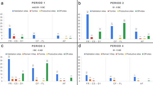
The wide occupation of fluvial ridges and crevasse splays indicates that most fluvial depositional processes were already deactivated during the mid. VII century BC. Since the Period1, these landforms have played an attractive role for rural settlements due to their elevated position above the floodplain and the associated low hydraulic hazard (a). Habitation sites are mainly found in the distal part of the coastal plain, near the lagoons and the sea, whereas other types of archaeological records are scarcely represented. The occurrence of tombs is mainly concentrated on the elevated surfaces of the fluvial ridges and crevasse splays persisting up to Period3. However, their limited number does not allow further consideration regarding their relationship with landscape dynamics.
Figure 6. Archaeological record distribution on the geomorphological features of the alluvial plain. High-elevated features (FR = Fluvial Ridges, CS = Crevasse Splays, D1 = Coastal Rear Dunes), low-elevated features (CF = Corniaccia Floodplain, FL = Floodplains), and Alluvial fans (AF). 6a) Period1; 6b) Period2; 6c) Period3; 6d) Period4.
5.2. Period2
The fluvial ridges are continuously settled in the distal part of the coastal plain, whereas new sites are also recorded in the northernmost sectors (b). Many habitation sites lasting up to Period4 are also recorded within the floodplain, which is characterised by higher hydraulic hazard. The presence of settlements and off-site records may indicate a management plan of surface waters for land use purposes (i.e. agricultural and pastoral activities) that resulted to relatively stable conditions in low-lying areas.
Rural settlements, lasting up to Period4, are recorded for the first time on the alluvial fan surfaces and the coastal rear dunes, suggesting the search for elevated areas above the low-lying flooded landscapes. On the other hand, the few known productive metallurgic sites are located in the easternmost part of the coastal plain, in the distal part of the Corniaccia floodplain and persisted up to Period3.
5.3. Period3
Whilst the total number of rural settlements remains relatively stable from Period2 (c), the most significant change is the transformation of some habitation sites, both on the fluvial ridges and the alluvial fan, into Roman villas. Notably, this evolution occurred on the most elevated sector of the floodplain, thus suggesting that central land management improved the intensive exploitation of low-land resources, following the reduction of smaller scattered settlements and the onset of a network of long-distance trading activities (CitationBotarelli & Cambi, 2005). According to the archaeological record distribution, the surface dynamics in the floodplain were stable, possibly due to a well-established hydraulic management system. At the same time, no settlements have been recorded in the lagoonal areas due to the relative stability at the sea-land interface.
5.4. Period4
The number of rural settlements suddenly decreased (d), and only villas and settlements located on the higher elevated landforms (i.e. alluvial fans) persisted during this period. However, no significant changes in local geomorphological dynamics are recorded (CitationPieruccini & Susini, 2020). The same trend is observed in most Italian provinces, mainly due to changing social, economic and political conditions (CitationCambi, 2009; CitationLo Cascio, 1994).
6. Conclusions
In order to disentangle the relationships between geomorphological and human dynamics, geoarchaeological analysis combining high-resolution topography models and archaeological databases is of utmost importance for the recognition of landforms and their relationships with settlement distribution. The geomorphological analysis of the Cornia coastal plain shows a very dynamic and heterogeneous system of high-elevated depositional landforms, generated by the diversion of the channel belt within the whole plain and the coastline migration, and low-elevated landforms, indicating lower-lying floodplains and swamps. The former became the first settled areas, whereas the lower-lying floodplains were inhabited and exploited only later.
Such analysis integrates geomorphological and archaeological databases and provides insights and methodological tools for assessing archaeological hazards in coastal landscapes where anthropic pressure have increased in recent times and a proper land planning is needed to reduce risks related to the loss of cultural heritage.
Software
ArcGIS Pro was used to design the final layout of the map. Data processing, including morphometric analysis, aerial photo-interpretation and archaeological database management, was carried out on QGIS, SAGA GIS and ArcGIS software.
Supplemental Material
Download ()Disclosure statement
No potential conflict of interest was reported by the author(s).
Data availability statement
Topographical maps, remote images, and digital models used for the basemap are free-downloaded from http://www.regione.toscana.it/web/geoblog/-/open-geodata.
Historical maps used for palaeoenvironmental analysis are free-downloaded from ‘Progetto CASTORE, Regione Toscana and Archivi di Stato Toscani’ https://www.regione.toscana.it/-/castore.
Additional information
Funding
References
- Amorosi, A., Ricci Lucchi, M., Sarti, G., Vaiani, S. C., Prandin, S., & Muti, A. (2004). Late Quaternary sedimentary evolution of the Piombino alluvial plain (western Tuscany) as revealed by subsurface data. GeoActa, 3, 97–106.
- Barazzuoli, P., Bouzelboudjen, M., Cucini, S., Kiraly, L., Menicori, P., & Salleolini, M. (1999). Olocenic alluvial aquifer of the River Cornia coastal plain (southern Tuscany, Italy): database design for groundwater management. Environmental Geology, 39(2), 123–143. https://doi.org/10.1007/s002540050443
- Bartolini, C., Ciprianni, L. E., Pranzini, E., & Sargentini, M. (1989). Caratteristiche geomorfologiche ed evoluzione della linea di riva del litorale toscano e criteri di lettura. Coste Toscane, 33–56.
- Bartolini, C., Pranzini, C., Lupia Palmieri, E., & Caputo, C. (1977). Studi di geomorfologia costiera: IV - L’erosione del litorale di Follonica. Bollettino della Società Geologica Italiana, 96(1-2), 87–116.
- Bellotti, P., Caputo, C., Davoli, L., Evangelista, S., Garzanti, E., Pugliese, F., & Valeri, P. (2004). Morpho-sedimentary characteristics and Holocene evolution of the emergent part of the Ombrone River delta (southern Tuscany). Geomorphology, 61(1–2), 71–90. https://doi.org/10.1016/j.geomorph.2003.11.007
- Benjamin, J., Rovere, A., Fontana, A., Furlani, S., Vacchi, M., Inglis, R. H., Galili, E., Antonioli, F., Sivan, D., Miko, S., Mourtzas, N., Felia, I., Meredith-Williams, M., Goodman-Tchernov, B., Kolaiti, E., Anzidei, M., & Gehrels, R. (2017). Late quaternary sea-level changes and early human societies in the central and eastern Mediterranean Basin: An interdisciplinary review. Quaternary International, 449, 29–57. https://doi.org/10.1016/j.quaint.2017.06.025
- Botarelli, L., & Cambi, F. (2005). Il territorio di Populonia fra il periodo etrusco tardo e il periodo romano. Ambiente, viabilità, insediamenti. Scienze dell’Antichità, 12(2004/2005), 23–43.
- Buonincontri, M. P., Pieruccini, P., Susini, D., Lubritto, C., Ricci, P., Rey, F., Tinner, W., Colombaroli, D., Drescher-Schneider, R., Dallai, L., Marasco, L., Poggi, G., Bianchi, G., Hodges, R., & Di Pasquale, G. (2020). Shaping Mediterranean landscapes: The cultural impact of anthropogenic fires in Tyrrhenian southern Tuscany during the iron and middle ages (800–450 BC / AD 650–1300). The Holocene, 30(10), 1420–1437. https://doi.org/10.1177/0959683620932978
- Cambi, F. (2009). Conclusioni. Populonia. Ferro, territorio e bacini di approvvigionamento fra il periodo etrusco e il periodo romano. In F. Cambi, F. Cavari, & C. Mascione (Eds.), Materiali da costruzione e produzione del ferro. Studi sull’economia populoniese fra periodo etrusco e romanizzazione (pp. 221–230). Edipuglia, Bari.
- Cataudella, S., Crosetti, D., & Massa, F. (2015). Mediterranean coastal lagoons: Sustainable management and interactions among aquaculture, capture fisheries and the environment studies and reviews. General fisheries commission for the Mediterranean No. 95. FAO.
- Censini, G., Costantini, A., Lazzarotto, A., Maccantelli, M., Mazzanti, R., Sandrelli, F., & Tavernelli, E. (1991). Evoluzione geomorfologica della pianura di Piombino (Toscana Marittima). Geografia Fisica e Dinamica Quaternaria, 14(1), 45–62.
- Cerrone, C., Vacchi, M., Fontana, A., & Rovere, A. (2021). Last interglacial sea-level proxies in the western Mediterranean. Earth System Science Data, 13(9), 4485–4527. https://doi.org/10.5194/essd-13-4485-2021
- Christian, C. S. (1958). The concept of land units and land systems. Proceedings of the Ninth Pacific Science Congress, 20, 74–81.
- Conti, P., Cornamusini, G., & Carmignani, L. (2020). An outline of the geology of the Northern Apennines (Italy), with geological map at 1:250,000 scale. Italian Journal of Geosciences, 129(2), 149–194. https://doi.org/10.3301/IJG.2019.25
- Currás, A., Ghilardi, M., Peche-Quilichini, K., Fagel, N., Vacchi, M., Delanghe, D., Dussouillez, P., Vella, C., Bontempi, J. M., & Ottaviani, J.-C. (2017). Reconstructing past landscapes of the eastern plain of Corsica (NW Mediterranean) during the last 6000 years based on molluscan, sedimentological and palynological analyses. Journal of Archaeological Science: Reports, 12, 755–769. https://doi.org/10.1016/j.jasrep.2016.09.016
- Dallai, L. (2016). Paesaggio e risorse: Il Monastero di San Quirico di Populonia, la pianura ed il promontorio di Piombino. In G. Bianchi, & S. Gelichi (Eds.), Un monastero sul mare. Ricerche a San Quirico di Populonia (Piombino, LI). All’Insegna del Giglio (pp. 89–108). Firenze.
- Di Rita, F., Celant, A., & Magri, D. (2010). Holocene environmental instability in the wetland north of the Tiber delta (Rome, Italy): sea-lake-man interactions. Journal of Paleolimnology, 1(51–67), 51–67. https://doi.org/10.1007/s10933-009-9385-9
- Fedeli, F. (1983). Populonia. Storia e territorio. Firenze.
- Fletcher, W. J., & Zielhofer, C. (2013). Fragility of western Mediterranean landscapes during Holocene rapid climate changes. Catena, 103, 16–29. https://doi.org/10.1016/j.catena.2011.05.001
- Galiberti, A. (1970). Stazioni preistoriche all'aperto nelle province di Grosseto e di Livorno. Rivista di Scienze Preistoriche, 25, 183–224.
- Ghezzi, G., Ghezzi, R., & Muti, A. (1993). Studio idrogeologico della pianura di Piombino (Pianura del fiume Cornia e terrazzo di S. Vincenzo Palmentello). Quaderni del Museo di Storia Naturale di Livorno, 2(13), 213–275.
- Giorgi, F., & Lionello, P. (2008). Climate change projections for the Mediterranean region. Global and Planetary Change, 63(2–3), 90–104. https://doi.org/10.1016/j.gloplacha.2007.09.005
- Giroldini, P. (2010). La pianura di Piombino in età antica: dinamiche di controllo e organizzazione territoriale (Doctoral Dissertation). Available from FLORE, University of Florence. http://hdl.handle.net/2158/558984
- Giroldini, P. (2012). Between land and sea: A GIS based settlement analysis of the ancient coastal lagoon of piombino (Tuscany, Italy). In W. Bebermeier, R. Hebenstreit, E. Kaiser, & J. Krause (Eds.), Landscape archaeology. Proceedings of the international conference held in Berlin, 6th – 8th June 2012 (pp. 383–389). Excellence Cluster Topoi.
- Grove, A. T., & Rackham, O. (2003). The nature of Mediterranean Europe: An ecological history. Yale University Press.
- Haldon, J., Roberts, N., Izdebski, A., Fleitmann, D., McCormick, M., Cassis, M., Doonan, O., Eastwood, W., Elton, H., Ladstätter, S., Manning, S., Newhard, J., Nicoll, K., Telelis, I., & Xoplaki, E. (2014). The climate and environment of byzantine anatolia: Integrating science, history, and archaeology. The Journal of Interdisciplinary History, 45(2), 113–161. https://doi.org/10.1162/JINH_a_00682
- ISPRA. (2018). Carta Geomorfologica d'Italia - 1:50.000, modifiche ed integrazioni al quaderno n. 4/1994. Roma.
- ISPRA-APAT. (1994). Carta Geomorfologica d’Italia 1:50.000, Guida al Rilevamento, Quaderno 4. Roma.
- Lambeck, K., & Purcell, A. (2005). Sea-level change in the Mediterranean Sea since the LGM: Model predictions for tectonically stable areas. Quaternary Science Reviews, 24(18–19), 1969–1988. https://doi.org/10.1016/j.quascirev.2004.06.025
- Lavorel, S., Canadell, J., Rambal, S., & Terradas, J. (1998). Mediterranean terrestrial ecosystems: Research priorities on global change effects. Global Ecology and Biogeography Letters, 7(3), 157–166. https://doi.org/10.1046/j.1466-822X.1998.00277.x
- Lo Cascio, E. (1994). La dinamica della popolazione in Italia da Augusto al III secolo. École Française de Rome, 198, 91–125.
- Londi, G., Biagini, P., Campedelli, T., Mini, T., & Tellini Florenzano, G. (2007). Storia ed ecologia del Padule di Scarlino. Comune di Scarlino.
- Luterbacher, J., Xoplaki, E., Casty, C., Wanner, H., Pauling, A., Küttel, M., Rutishauser, T., Brönnimann, S., Fischer, E., Fleitmann, D., Gonzalez-Rouco, F. J., García-Herrera, R., Barriendos, M., Rodrigo, F., Gonzalez-Hidalgo, J. C., Saz, M. A., Gimeno, L., Ribera, P., Brunet, M., … Ladurie, E. L. R. (2006). Chapter 1 Mediterranean climate variability over the last centuries: A review. Developments in Earth and Environmental Sciences, 4, 27–148. https://doi.org/10.1016/S1571-9197(06)80004-2
- Manning, S. (2013). The roman world and climate: Context, relevance of climate change, and some issues. In W. Harris (Ed.), The ancient Mediterranean environment between science and history (pp. 103–170). Brill. https://doi.org/10.1163/9789004254053_007
- Mariotti Lippi, M., Guido, M., Menozzi, B. I., Bellini, C., & Montanari, C. (2007). The Massaciuccoli Holocene pollen sequence and the vegetation history of the coastal plains by the Mar Ligure (Tuscany and Liguria, Italy). Vegetation History and Archaeobotany, 16(4), 267–277. https://doi.org/10.1007/s00334-006-0090-6
- Marriner, N., Morhange, C., Kaniewski, D., & Carayon, N. (2014). Ancient harbour infrastructure in the Levant: Tracking the birth and rise of new forms of anthropogenic pressure. Scientific Reports, 4(1), 1–11. https://doi.org/10.1038/srep05554
- Marzano, A. (2007). Roman villas in central Italy: A social and economic history. Brill.
- Mattei, G., Caporizzo, C., Corrado, G., Vacchi, M., Stocchi, P., Pappone, G., Schiattarella, M., & Aucelli, P. P. C. (2022). On the influence of vertical ground movements on late-quaternary sea-level records. A comprehensive assessment along the mid-Tyrrhenian coast of Italy (Mediterranean Sea). Quaternary Science Reviews, 279, 107348. https://doi.org/10.1016/j.quascirev.2022.107384
- Mazzanti, R., Pranzini, P., & Taccini, S. (1981). Studi di geomorfologia costiera: VII - Variazioni della linea di riva dal Pleistocene medio-superiore ad oggi, caratteristiche sedimentologiche e stato delle associazioni vegetali del Litorale di San Vincenzo (Toscana). Bollettino della Società Geologica Italiana, 99(4), 341–364.
- McCormick, M., Büntgen, U., Cane, M. A., Cook, E. R., Harper, K., Huybers, P., Litt, T., Manning, S. W., Mayewski, P. A., More, A. F. M., Nicolussi, K., & Tegel, W. (2012). Climate change during and after the roman empire: Reconstructing the past from scientific and historical evidence. The Journal of Interdisciplinary History, 43(2), 169–220. https://doi.org/10.1162/JINH_a_00379
- Melis, R. T., Di Rita, F., French, C., Marriner, N., Montis, F., Serreli, G., Sulas, F., & Vacchi, M. (2018). 8000 years of coastal changes on a western Mediterranean island: A multiproxy approach from the Posada plain of Sardinia. Marine Geology, 403, 93–108. https://doi.org/10.1016/j.margeo.2018.05.004
- Morellón, M., Sinopoli, G., Izdebski, A., Sadori, L., Anselmetti, F., Hodges, R., Regattieri, E., Wagner, B., Brushulli, B., & Ariztegui, D. (2016). Environment, climate and society in roman and byzantine butrint. Late Antique Archaeology, 12(1), 3–17. https://doi.org/10.1163/22134522-12340063
- Pieruccini, P., & Susini, D. (2020). The Holocene sedimentary record and the landscape evolution along the coastal plains of the Pecora and Cornia rivers (Southern Tuscany, Italy): preliminary results and future perspectives. In G. Bianchi, & R. Hodges (Eds.), The nEU-Med project: Vetricella, an early medieval royal property on Tuscany’s Mediterranean (pp. 161–168). All’Insegna del Giglio.
- Pieruccini, P., Susini, D., Buonincontri, M. P., Bianchi, G., Hodges, R., Lubritto, C., & Di Pasquale, G. (2021). Late Holocene human-induced landscape changes in Calcareous Tufa environments in Central Mediterranean valleys (Pecora river, Southern Tuscany, Italy). Geomorphology, 383, 107691. https://doi.org/10.1016/j.geomorph.2021.107691
- Ponta, E. (2019). Il Paesaggio e le sue trasformazioni tra IV e VIII sec d.C. tra costa ed entroterra. Il caso della Toscana centro meridionale (Doctoral dissertation). Available from ETD, University of Pisa. URN: etd-01292019-131116.
- Roberts, N., Stevenson, T., Davis, B., Cheddadi, R., Brewster, S., & Rosen, A. (2004). Holocene climate, environment and cultural change in the circumMediterranean region. In R. W. Battarbee, F. Gasse, & C. E. Stickley (Eds.), Past climate variability through Europe and Africa (pp. 343–362). Springer. https://doi.org/10.1007/978-1-4020-2121-3_17
- Rossi, V., Amorosi, A., Sarti, G., & Potenza, M. (2011). Influence of inherited topography on the Holocene sedimentary evolution of coastal systems: An example from Arno coastal plain (Tuscany, Italy). Geomorphology, 135(1–2), 117–128. https://doi.org/10.1016/j.geomorph.2011.08.009
- Rossi-Doria, M., & Bevilacqua, S. (1984). Le bonifiche in Italia dal ‘700 a oggi. Laterza, Roma-Bari.
- Ruello, M. R., Cinque, A., Di Donato, V., Molisso, F., Terrasi, F., & Russo Ermolli, E. (2017). Interplay between sea level rise and tectonics in the Holocene evolution of the St. Eufemia Plain (Calabria, Italy). Journal of Coastal Conservation, 21(6), 903–915. https://doi.org/10.1007/s11852-017-0558-9
- Sacchi, M., Molisso, F., Pacifico, A., Vigliotti, M., Sabbarese, C., & Ruberti, D. (2014). Late-Holocene to recent evolution of Lake Patria, South Italy: An example of a coastal lagoon within a Mediterranean delta system. Global and Planetary Change, 117, 9–27. https://doi.org/10.1016/j.gloplacha.2014.03.004
- Seif, A., & Ebrahimi, B. (2014). Combined use of GIS and experimental functions for the morphometric study of glacial cirques, Zardkuh Mountain, Iran. Quaternary International, 353, 236–249. https://doi.org/10.1016/j.quaint.2014.07.005
- Vacchi, M., Marriner, N., Morhange, C., Spada, G., Fontana, A., & Rovere, A. (2016). Multiproxy assessment of Holocene Sea-level variability and improvements in the definition of the isostatic signal. Earth Science Review, 155, 172–197. https://doi.org/10.1016/j.earscirev.2016.02.002
- Vittori, C., Mazzini, I., Salomon, F., Goiran, J.-P., Pannuzi, S., Rosa, C., & Pellegrino, A. (2015). Palaeoenvironmental evolution of the ancient lagoon of Ostia Antica (Tiber delta, Italy). Journal of Archaeological Science, 54, 374–384. https://doi.org/10.1016/j.jas.2014.06.017
- Zonneveld, I. S. (1989). The land unit - a fundamental concept in landscape ecology, and its applications. Landscape Ecology, 3(2), 67–86. https://doi.org/10.1007/BF00131171