
ABSTRACT
Seismic lines and sediment cores collected along the shelf between Albenga and Loano (Liguria, NW Italy) allowed an unprecedented reconstruction of the characters and distribution of late Quaternary transgressive littoral deposits. Multiple seismic lines datasets and stratigraphic logs were managed within a single, GIS-based software. This approach allowed the merging, analysis, and interpretation of multimethodological datasets, greatly increasing the understanding of the study area. On seismic reflection lines, the identification of high-amplitude acoustic facies (i.e. coarse-grained deposits), coupled with the analyses of the identified paleo-morphologies, allowed the mapping of (at least) five paleo shorelines along the continental shelf at 30–40 40–60, 60–80, 80–90 and 90–100 m below sea level. Their retrogradiational geometry and terraced distribution likely indicate episodic, stepwise retreats of Late Quaternary coastal system (last 18–11 Ky), compatible with phases of fast sea level rise interspersed by long periods of sea level stillstand.
1. Introduction
The stratigraphy and morphology of continental shelves record the complex interplay between marine processes and offshore sediment transportation. This includes the reworking of sediments by waves, currents, gravity-driven flows and the lithoclastic and biogenic suspended matter settling, combined with eustatic fluctuations, climate changes, sediment accommodation space variation and tectonics, while control the geomorphic evolution and geometries of the continental shelf sedimentary successions (CitationCattaneo & Steel, 2003; CitationWeimer & Shipp, 2004; CitationGamberi et al., 2017; CitationDistefano et al., 2019; CitationFerrando et al., 2021). These latter are very sensitive to eustatic sea level change that are witnessed by the landward or seaward migration of the coastline (e.g. CitationDistefano & Gamberi, 2022; CitationBorzì et al., 2021; CitationMolina et al., 2019). Landward migration cycles are usually associated with (i) increased sedimentation rates within alluvial and coastal plains, (ii) decreased sediment influx into the basin, and (iii) reworking of ancient deposits (e.g. CitationDistefano et al., 2021; CitationCattaneo & Steel, 2003). Typical sedimentological facies of these transgressive deposits (developed in fully marine and/or littoral/estuarine/lagoonal/fluvial environments) are (i) transgressive dune-field systems (CitationHesp, 2013; CitationPicart & Hesp, 2019), (ii) cuspate beaches (CitationWright & Short, 1984), (iii) coastal barrier-lagoons (CitationDistefano & Gamberi, 2022; CitationDistefano et al., 2021; CitationOertel et al., 1992; CitationCattaneo & Steel, 2003) and (iv) transgressive sheets (CitationSwift et al., 1971). Thus, the investigation of ancient and recent transgressive successions is fundamental to reconstruct eustatic sea-level behavior and its link to climate change and local tectonics.
In this framework, the continental shelf developed between Albenga and Loano ((a and b)) represents an excellent site to study the evolution of the Late Quaternary Transgressive System Tract (TST, hereafter) in the Ligurian Sea. This latter represents the northern propagation of the Sardo-Provençal and Tyrrhenian back-arc basins produced, since the upper Oligocene, by the southeasternward roll-back of the Apennines-Maghrebides subduction zone (CitationLarroque et al., 2011 and references therein).
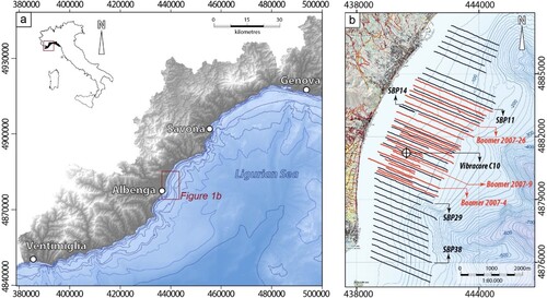
Figure 1. Geographical setting of the study area. (a) Schematic map of the Ligurian Sea and location of the study area. (b) Bathymetric map of the study area derived from the EMODnet data (CitationFiorentino et al., 2021) with the location of the seismic lines. Black lines: Sub Bottom profiles (SBP); Red lines: Boomer seismic lines.
During the lowstand phase of the Last Glacial Maximum (∼18 Kyr BP; LGM hereafter), the average sea level in the Ligurian Sea was ∼110–120 m lower than today with a large portion of the continental shelf exposed (e.g. CitationVail et al., 1977; CitationVan Wagoner et al., 1988, Citation1990 and CitationVan Wagoner, 1995). Here, the sedimentary sequences were dominated by the deposition of watercourses-fed progradional sedimentary bodies (Lowstand Systems Tract, LST) mainly deposited in marine and littoral paleo-environments (e.g. CitationBalduzzi et al., 2008; CitationCorradi et al., 1984; CitationFanucci et al., 1995; CitationDalla Giovanna et al., 2016; CitationGiammarino et al., 2010). During the Versilian (from the LGM to 11 Kyr BP), the eustatic sea-level rise drove the migration of the coastal zone from the shelfbreak to its present-day position. As the migration was episodic in time, transgressive deltaic and/or littoral systems deposits (e.g. paleodeltas and/or paleobeaches) were formed at intermediate bathymetries during periods of slowing down of sea-level rise. Their morphologies, characters and geometries can be seismically identified and provide invaluable insights on the geodynamic and paleoclimatic evolution of coastal areas (e.g. CitationAguirre et al., 2006; CitationBentley & McCulloch, 2005; CitationAbbott, 1998; CitationPeeters et al., 2019; CitationFoyle & Oertel, 1997; CitationMassari et al., 2007; CitationAmorosi et al., 2022) and can be potential resources for beach nourishment (e.g. findings from BEACHMED project: CitationBalduzzi et al., 2008; CitationBozzano et al., 2006).
From a geological and geomorphological point of view, the continental shelf of the study area is fed by sedimentary input provided by various watercourses ((a and b)); the main ones are the Centa River (to the South) and the Nimbalto Stream to the North ((a)). Here the continental shelf is wide, without evidence of submarine gravitative collapses nor canyons carve ((b)); in the internal sector, where the acoustic substratum is locally suboutcropping ((a)), it is mainly covered by muddy Holocene deposit of variable thickness (CitationBalduzzi et al., 2008; CitationIvaldi et al., 2006; CitationCorradi et al., 1984; CitationFanucci et al., 1995; CitationCorradi, 1980). Moving seaward, the continental slope is dominated by gravitative movements focused within submarine canyons heads (CitationMorelli et al., 2021 and Citation2022), especially at the front of the Centa River submerged fan (CitationCorradi et al., 1984).
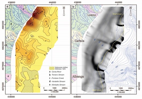
Figure 2. (a) thickness (in meters) of the TRF seismic unit (seismic wave velocity of 1650 m/sec TWTT), corresponding to the Holocene Lutites. (b) Morpho-bathymetric map of the study area showing the location of the shelf-break and the three heads of Albenga, Ceriale and Loano Canyons.
Along the Albenga-Loano continental shelf the local.
morphological setting has driven an accumulation of transgressive littoral and deltaic deposits which is unmatched in any other part of the Ligurian margin.
The aim of this paper is to present an updated mapping of the distribution and characters of the TST sedimentary bodies and the younger Holocene lutites, with a detailed description of the geometries of the paleo deltaic and littoral systems.
2. Methods
This study is based on the interpretation of 150 km of seismic lines acquired with a 3.5 kHz Sub-Bottom Profiler and a 200–400J Boomer on a grid with 300 m spacing between each line ((b)). All these seismic data are derived from the Beachmed and Beachmed-e projects, acquired respectively in the years 2004 and 2007. The reflection seismic data, all available in digital XTF format, were processed and interpreted within the GIS-based software Geosuite AllWorks®. The accuracy of seismic lines interpretation was checked correlating the thicknesses of seismo-stratigraphic units derived from the vibracore C10 (data from Beachmed project) to those picked on the Boomer line 2007–2009. Once interpreted all the available seismic lines, the depths of the reflectors of both the Holocene mud covers and the TST transgressive sedimentary bodies were exported to retrieve the map of the Holocene mud thicknesses and the 3D model of the TST surface. This was achieved interpolating the depths data with kriging methods in QGIS 3.16 ‘Hannover’ (using the Smart-Map plugin of CitationPereira et al., 2022). The preliminary map was drafted on QGIS 3.16 ‘Hannover’; the final map was assembled and graphically optimized with Inscape (release 1.2).
3. Results
3.1. Seismic-stratigraphic analysis
In the study area, Sub-Bottom Profiler (SBP) and Boomer seismic lines allowed the identification of a Late Quaternary sedimentary layer characterized by high amplitude reflection facies (HARF hereafter; (a, b) and (a, b)) delimited by the reflectors TS (at the base) and THARF (at the top).
Figure 3. Seismo-stratigraphic architecture of the shelf area in front of Albenga and summary of the identified seismo-stratigraphic units and surfaces of the late Quaternary sequence. The acronyms with their corresponding chrono-stratigraphic units from literature are also indicated. (a) Boomer line 2007–4 showing the thick Plio-Pleistocene deposits buried by the HARF deposits (mainly gravels and sands) and the recent HST deposits (constituted by fine-grained sands and muds). (b) detail of Boomer line 2007–4 highlighting the internal architectures of the Late Quaternary sequence. It is visible, in detail, the retrogressive overlap pattern of the high-amplitude reflective subunits (respectively: TST1-5) and the presence of a buried, very high-amplitude subunits (BHARF) at the base of the transgressive unit.
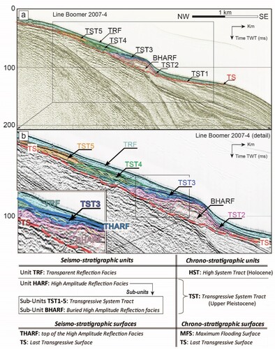
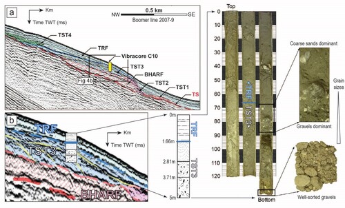
Figure 4. (a) Seismic Boomer line 2007–9 showing the seismo-stratigraphic units TRF, TST3, and their separating surface THARF calibration based on Vibracore C10 data sampling. (b) Vibra-core sampling log reconstruction and a related photo image of coarse littoral sediments (sands and gravels) of the transgressive TST3 subunits and muddy offshore deposits of the TRF unit, corresponding with the Transgressive Systems Tract (TST) and High Stand Systems Tract (HST), respectively.
The basal TS reflector shows a clear erosive character and gradually deepens towards the shelf-break ((a, b) and (a, b)); it is characterized by high amplitude reflectivity and high lateral continuity. This regional-scale unconformity is buried by the coarse-grained transgressive deposits belonging to the Transgressive System Tract (TST) also identified along other sectors of the Ligurian shelf (e.g. CitationGiammarino et al., 2010; CitationDalla Giovanna et al., 2016). The TS unconformity cuts the prograding reflectors belonging to the Upper Pleistocene deposits. These deposits are well identified and continuous in the outer shelf area, but more scattered and chaotic in the middle and inner shelf ((a)). Furthermore, the TST deposits result more evident in the most penetrative Boomer lines, rather than in the Sub Bottom Profiler lines (characterized by very high-resolution) where their identification is poor (, and ). The Boomer seismic lines show the internal stratigraphic architecture of the HARF deposits ((a, b), (a, b)) which locally represent the acoustic substratum due to their tendency to absorb the SBP's high-frequency signal. The stratigraphic architecture shows an overall wedge-shaped geometry and seaward thickening, characterized by the retrogressive overlap of high amplitude reflective subunits (respectively: TST1, TST2, TST3, TST4 and TST5); locally, mounded and tabular shapes are also identified ((a, b) and (a, b)). The TST subunits are characterized by stratified facies with a foreset of inclined reflectors that prograde with downlap terminations. This architecture, observed in the entire shelf area, is more evident between Albenga and Ceriale where the high reflective deposits are between 6 and 10 m thick ((a, b) and (a, b)).
Figure 5. (a) Seismic SBP line 29 showing the common terraced-like arrangement of the HARF Sub-units deposits (TST1-5). (b) Three-dimensional view of the SBP lines showing the high lateral continuity of the HARF subunits highlighted by the high amplitude reflection facies and the terraced arrangement.
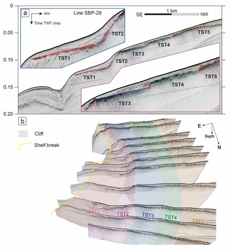
In the shelf area the top of the HARF unit is delimited by the well-evident and continuous reflector THARF, recorded both by the Boomer and the SBP lines. The THARF reflector is generally slightly inclined towards the shelf break and shows several levels of terraces ((a, b) and (a, b)). This latter present good lateral continuity and can be followed at constant depths (ranges: ∼30-40 40-60, 60-80, 80–90 and 90–100 below sea level) along the entire study area. Such sets of terraces describe the steps of retrogressive overlapping of the HARF subunits (the TST1-5), thus coinciding with the Holocene landward migration of the coastal transgressive deposits ((a, b) and (a, b)).
Locally, the THARF reflector is draped by a layer characterized by low to transparent acoustic reflection (TRF, hereafter; (a, b) and (a, b)), commonly interpreted as deposits belonging to the High Stand Systems Tract (the HST of CitationBalduzzi et al., 2008; CitationDistefano & Gamberi, 2022). This interpretation is supported by the vibracore sedimentary log ((a, b)) which shows at 1.66 m depth a sharp litho-facies transition with the Holocene muds (belonging to the HST) capping the coarser transgressive sedimentary bodies belonging to the TST deposits ((b)).
This transition, corresponding to the THARF reflector, represents the maximum flooding surface (also MFS; CitationCattaneo & Steel, 2003). The thicknesses of the TRF deposits appears controlled by the sedimentary inputs of the main rivers, such as the Ceriale and the Centa, and decreases towards the shelf edge. A main depocenter (with thicknesses up to 15 m; (a)) is located in front of Albenga and likely correspond to the location of the main alluvial fan of the Centa River before its deviation occurred in the XV century (CitationBellotti, 2000). Two main depocenters (with thicknesses up to 20 meters) are also located in the northern sector of the study area near the town of Loano ((a)) and suggest high sedimentary inputs by Nilbalto and Varatello streams.
Notably, in front of Albenga, the TRF deposits gradually decrease at the transition from middle to outer shelf and disappears along the three canyon heads affecting the edge of the shelf area ( (a, b)).
3.2. HARF subunits: distribution and characters of TST and BHARF deposits
In plan view the HARF sub-units deposits (TST1-5) are located at constant depth intervals and develop, along strike, sub-parallel to the present-day shoreline. Despite their common terraced-like arrangement (e.g. , , , and ), these TST units differ in shape and extent due to the different morpho-structural settings and rate of sedimentary input controlling their deposition. Generally, the TST show mounded shapes (often with a rough profile) with gentle flanks delimited by small scarps, locally counter-slope with respect to the shelf gradient ((a, c)). Nevertheless, the TST deposits can also develop narrow ridges with steep flanks, locally coinciding with paleo-cliffs () and (c)).
Figure 6. (a) Seismic SBP line 14 (trace in (b)) showing the features of the TST subunits in the shelf area along the Monte Croce High. (b) Seismic Boomer line 2007–26 showing the Plio-Pleistocene morphostructural high outcropping in the outer shelf area bounded by a fault zone with NW dip. Green and orange dashed lines indicate the main Plio-Pleistocene reflectors.
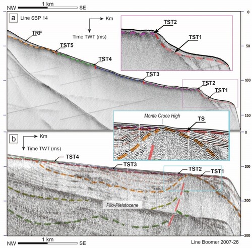
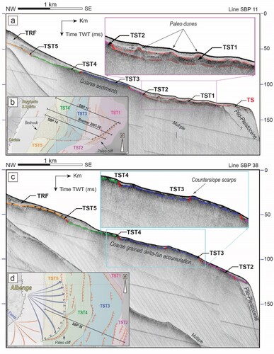
Figure 7. (a) Seismic SBP line 11 shows the accumulation features of the TST1 subunit in the outer shelf area, consisting of symmetrical, high-reflective ridges with troughs filled with less reflective deposits. (c) Seismic SBP line 38 showing a thickness of the TRF unit minimal, or absent, while the THARF reflector is generally more irregular associated with small depressions and sub-outcropping reliefs. (b) and (d) Insets of the TST subunits distribution map with the location of the seismic lines.
3.2.1. Northern sector
Among the paleo-morphological elements present in the study area, the (i) paleo-deltaic system produced by the sedimentary input of the Centa River and (ii) the pronounced WNW-ESE morphostructural high E of Ceriale (the Monte Croce High, MCH hereafter) are the two main morphological elements controlling the development of the TST sub-units. The first one extends from Albenga (where the Centa River delta system extends farther to the south, out of the mapped area) and is delimited, to the north, by the Monte Croce High (MCH, hereafter; (b), see Main Map). MCH crosscuts the entire shelf for ∼2.5 km and correspond to an acoustic substratum feature which represent the seaward extent of the most prominent coastal relief bounding the alluvial plain of Albenga ((a, b) and (b)). Towards the outer shelf, the MCH is connected to a WSW-ENE oriented narrow and elongated morphostructural high, ∼2 km long ((b)).
These morphostructural highs influence the shelf morphology down to ∼80 m below the sea level, producing a large and relatively flat seabed area raised and elongated in a WNW-ESE direction ((b)). Here, the top of the HARF deposits (marked by the THARF reflector) is highly articulated and characterized by wide terraces (up to 1100 m width for the TST1) bordered by NE-SW scarps of variable size elongated sub-parallel to the coastline ((a, b)).
Along the MCH, the erosive base of the TS surface is shallower ((a, b)) and this strongly affects the distribution and extension of the HARF deposits, notably for the subunits TST5, TST4 and TST3. In map view they appear shifted and arcuated towards the open sea ((b)); moreover TST3, TST2 and TS1 are here wider with respect to the southern sector, reaching their maximum areal extension in the middle and outer shelf ((b)). TST1 is the wider one and forms the relatively flat area between the shelf edge to the NE and the NE-SW oriented topographic high to the SW ((b)). Here, peculiar accumulation features, consisting in a set of symmetrical high-reflective N-S ridges, are alternated by troughs filled with less reflective deposits ((a)). TST3 unit shows acoustic facies constituted by thick and very high-reflective deposits, which form a wide ridge with well-developed lateral continuity ((b)). Here, the overall TST3 architecture presents a mounded shape with well-carved scarps (both internal and along the TST3 border), locally in counterslope with respect to the shelf gradient ((a)).
3.2.2. Southern sector
South of the MCH, the HARF deposits are significantly thicker than in the northern sector, with a clear retrogradation stacking pattern of the TST Subunits ((a, b), (a, b) and (a)).
The thickening of the HARF unit is more marked along the shelf south of the locality of Pineo. Such an increase is due to the BHARF subunit, a buried wedge-shaped sedimentary body deposited at the base of the HARF. The BHARF becomes progressively thicker to the south, where it advances towards the shelf edge reaching the head of the Albenga Canyon. Despite its highly reflective top surface, the BHARF is less reflective or acoustically transparent, without evident or continuous reflectors ((a, b)).
The HARF stratigraphic architecture is characterized by the steep THARF surface, which show a terraced arrangement in continuity with the northernmost sector. The terraces, each corresponding to a specific TST subunit, consist of a gently sloping tread with variable extension ((b)). In the shelf sector in front of Ceriale, the THARF reflector is generally more irregular, with small depressions and sub-outcropping reliefs ((a, d)). Here terraces scarps have little lateral continuity, sometimes in counter slope with respect to the general slope of the shelf ((c)). To the south, between the localities of Pineo and Albenga, the scarps bounding the TST3 and TST2 subunits have higher lateral continuity (e.g. (a, b)) with respect to the scarps bounding the other subunits, especially along the Centa River delta system ((c, d)).
South of the MCH, the TST1 subunit consists of a thin and discontinuous layer of sediments overlying an extensive erosional plain surface (TS reflector) located at a depth between 100 and 90 meters below the present-day sea level (outer shelf, (a)).
Despite its limited thickness, in the southern sector the TST1 subunit reaches its maximum extent and is delimited, towards the coast, by an evident and continuous scarp ((a)) characterized by steeper slopes and marking the transition towards the inner shelf ((a, b), (a, b). This broad and steep slope (named the Pineo-Albenga paleocliff, herafter) coincides with the front of the BHARF deposits and gradually replaces the TST2 terraces ((b)). It shows an arcuate shape and at the shelf break is connected to the southern flanks of the Albenga canyon head.
4. Discussion
Based on seismo-stratigraphic analysis, we have mapped and characterized the distribution of the Late Quaternary sedimentary bodies (HARF and TRF, (a, b)) within the Albenga-Loano shelf area (see Main Map). The HARF and TRF are deposited on the transgressive erosional surface TS (also known as ‘wave ravinement surface’; Zecchin et al., Citation2019 and references therein) formed during the Last Glacial Maximum transgression and are separated by the THARF surface within the entire shelf area. Based on vibracore sampling correlation, the THARF reflector coincides with a sharp upward deepening of facies from coarse littoral sediments to offshore deposits. Thus, the THARF correspond to the maximum flooding surface, provides a record of sea level rise since the LGM and define features and distributions of the shelf paleo-morphologies.
In the study area, and in particular between Ceriale and Pineo, the steep THARF surface is characterized by an evident step-like morphology associated with a retrogradational stacking pattern of TST subunits. This stratigraphic architecture was clearly controlled by marked episodes of sea-level rise, with episodic landward shoreline migration (e.g. producing the ‘retrogradational parasequence set’ of CitationCattaneo & Steel, 2003) but also influenced by other factors such as changes in sea wave energy, variation of sediment supply rates and transgressive surface steepness.
The analysis and 3D interpretation of the seismic lines reveal a high lateral continuity of all the identified TST subunits, distributed along bands located at constant depth intervals (ca 30–40, 40–60, 60–80, 80–90 and 90–100 m below the present sea-level, BPSL hereafter) and sub-parallel to the present-day coastline, with variable extent and shapes. Aside from the eustatic sea-level rise, the variability of the TSTs distribution is also controlled by (i) rates of sedimentary inputs (especially for the paleo-Centa River system) and (ii) changes of the morpho-structural highs (e.g. the MCH) along the coastline since the LGM.
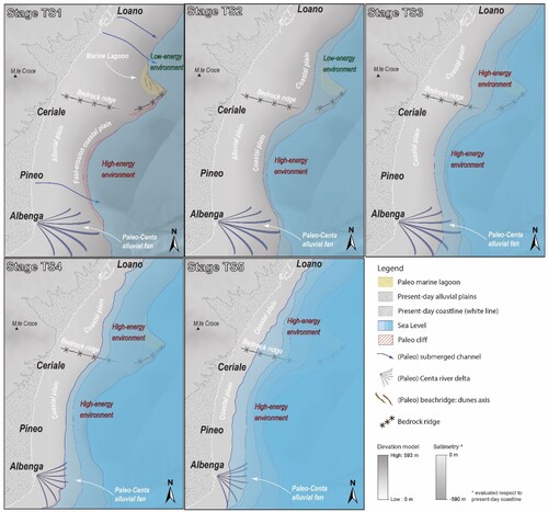
In the following we propose an evolutionary history for the Late Quaternary coastal morpho-structures of the study area () characterized by five distinct stages based on the areal distribution of the five transgressive subunits. These phases formed during periods of sea-level rise and still-stand. The abrupt sea-level changes, together with local high-rates of sedimentation, played a fundamental role in fossilizing the transgressive subunits and the related geomorphological features (e.g. scarps, paleochannel incisions, paleo-lagoons, littoral spits, dunes, etc.) which were buried by the new incoming sediments.
Figure 8. Palaeo-environmental reconstruction of the evolution of the coastal areas between Albenga and Loano since the Last Glacial Maximum. The evolutions steps TST 1, TST2, TST3, TST4 and TST5 were reconstructed based on the distribution of the transgressive deposits TST and their paleo-morphologies.
The observed migration of the transgressive deposits and related paleo-morphological features towards the inland, is consistent with other case history in the Mediterranean area (e.g. CitationDistefano & Gamberi, 2022; CitationCattaneo & Steel, 2003), highlighting the correlation between the migration of transgressive deposits along the shelf and the global shortstand phases of sea-level rise (e.g. CitationCattaneo & Steel, 2003; Helland-Hansen & Gjelberg, Citation1994; Liù et al., Citation2001; CitationSwift et al., 1971).
4.1. Evolution history of the HARF unit
Stage TST1 – After the LGM, sea-level rise promoted deposition on the TS of a thin and discontinuous transgressive layer TST1 (, , , and ) deposited on the most distal and flat sectors of the paleo tidal plain. At this stage, the MCH promontory controlled the formation of two inlets: the larger one (between Ceriale and Pineo) was delimited, to the south, by the large front of the Paleo Centa River delta (). Prominent cliffs characterize the massive deposits of the paleo-delta, a typical record of the interplay between massive sedimentary input and high-energy marine erosion. The smaller inlet to the north was preserved from open sea, high-energy erosional processes (i.e. tempest waves) and inshore currents as witnessed by the local occurrence of coarse-grained, dune-shaped accumulations (length along strike up to ∼1 km, width up to ca 200 m) interspersed with lagoon fine-grained deposits (). Eventually, the overall architecture of the paleo coastline was deeply influenced by the MCH, which marked the transition from a high-energy (S embayment) to a low-energy erosional environment (N embayment).
Stage TST2 – Renewed rapid sea level rise led to the formation of the TST2 subunit, deposited on the shelf between ∼90-80 m BPSL (, , , and ). A thick and continuous terraced accumulation of coarse-grained sediments prograded on a locally slightly steeper trasgressive surface TS apart from the shelf area between Pineo and Albenga (). Here the coastal paleo-morphology, dominated by a prominent and steep cliff, points to the occurrence of a dynamically built-up paleo-delta fed by sediments of the paleo Centa River (e.g. the BHARF subunit). This morphology confirms the persistence of a high-energy erosional environment in the southern embayment but not in the northern one, still characterized by undisturbed TST2 deposition (i.e. low-energy erosional environment).
Stage TST3 – The progradation and accumulation of the TST3 subunit (∼80-60 m BPSL) is related to the stillstand of sea-level after a quick rise. During this stage the accumulation of sediments led to the overstep of older cliffs and to the complete burying of the older TST1, TST2 and BHARF deposits. Along the southern flank of the MCH, the massive accumulations were likely fed by the erosion of nearby exposed bedrock, as suggested by the presence of coarse-grained and poorly sorted sediments (i.e. the low penetrative seismic facies). All over the study area TST3 subunit is dominated by terraced deposits with tabular and wide ridges suggesting open shoreline depositional environments, with strong cross shore currents. The progressive drowning of the MCH is almost complete, eventually enhancing the effects of marine erosion along the northern inlet ().
Stages TST4 and TST5 – Subsequent sea-level rise controlled the coastline migration with retrogradation of the TST4 and TST5 coarse-grained coastal deposits (deposited respectively at depths of ∼60-40 and ∼40-30 m BPSL). From stage TST4 the influence on the depositional environments of the MCH and of the fault activity became negligible, testified by the complete absence of any coastal inlets (). The occurrence of typical morphostratigraphic features of marine delta systems (e.g. short and lobate scarps, small depressions, sub-outcropping reliefs, arcuated cliffs and infilled channels) interspersed with small lagoons, suggests the transition to a depositional environment dominated by the paleo-Centa delta system (the largest along the Ligurian coast).
Interestingly, since the onset of TST5 deposition, the coastal morphology between Ceriale and Pineo is dominated by regular terracing instead of short and lobate scarps (, and ). This geometry, mostly controlled by retrogressive erosion operated by sea-level changes, shows a local decrease of the fluvio-deltaic sedimentary rates. This suggests the migration of the Paleo Centa depocenters towards the south. This process, active since the TS4 stage, was eventually accomplished with the deposition of the TRF deposits. The occurrence of a main depocenter east of Albenga (with thicknesses up to 15 m; (a)) likely corresponds to the last location of the main alluvial fan of the Centa River before its regimentation occurred in the XV century (CitationBellotti, 2000).
5. Conclusions
The identification, mapping and characterization of Late Quaternary transgressive deposits have allowed the reconstruction of the paleo-environmental evolution of the shelf areas between Albenga and Loano (NW Italy), which is exceptionally articulated in time and space. The general retrogressive character of the transgressive unit, highlighted by the distribution of the various subunits, is associated with distinct morphological and seismo-stratigraphic characters along the different shelf sectors. These latter allowed the recognition, since the last glacial maximum, of five distinct phases of landwards shoreline migration, leading to the deposition of transgressive subunits. Their distribution, depositional architecture and morphodynamic evolution were locally controlled by the inherited morpho-structural elements (such as the structural highs) and the location of paleo-delta conoids fed by the sedimentary input of the main rivers (e.g. the Centa River). The five distinct phases suggest episodic transgression, with rapid sea-level rise followed by phases of sea-level stillstand, consistent with what is observed at the regional scale in the Mediterranean Sea. This confirms that the distribution of the transgressive deposits (and thus the episodic migration of the coastline) is influenced by the combined interaction of local and global factors.
Software
Seismic lines and the stratigraphic log were analysed within the GIS-based software: Geosuite AllWorks® (https://geomarinesurveysystems.com/products/software/allworks/). The modelling of the 3D surfaces and the evaluation of the thickness for the TST transgressive sedimentary bodies and the TRF Holocene mud covers was achieved using the Q-GIS kriging plugin ‘Smart-Map’ (https://github.com/gustavowillam/SmartMapPlugin). The final map was assembled and graphically optimized on Inscape (release 1.2).
Supplemental Material
Download MS Word (13.2 KB)MAINmapREV1.pdf
Download PDF (33.9 MB)Acknowledgements
We thank the officers and crew of R/V Messico and the DrafinSub company that acquired the data.
Disclosure statement
No potential conflict of interest was reported by the author(s).
Additional information
Funding
References
- Abbott, S. T. (1998). Transgressive systems tracts and onlap shellbeds from mid-Pleistocene sequences, Wanganui Basin, New Zealand. Journal of Sedimentary Research, 68(2), 253–268. doi:10.2110/jsr.68.253
- Aguirre, M. L., Richiano, S., & Sirch, Y. N. (2006). Palaeoenvironments and palaeoclimates of the Quaternary molluscan faunas from the coastal area of Bahía Vera-Camarones (Chubut, Patagonia). Palaeogeography, Palaeoclimatology, Palaeoecology, 229(4), 251–286. doi:10.1016/j.palaeo.2005.06.025
- Amorosi, A., Bruno, L., Caldara, M., Campo, B., Cau, S., De Santis, V., Di Martino, A., Hong, W., Lucci, G., Pellegrini, C., Rossi, V., Sammartino, I., & Vaiani, S. C. (2022). Late Quaternary sedimentary record of estuarine incised-valley filling and interfluve flooding: The Manfredonia paleovalley system (southern Italy). Marine and Petroleum Geology, 105975. https://doi.org/10.1016/j.marpetgeo.2022.105975
- Balduzzi, I., Bozzano, A., Corradi, N., Ferrari, M., Ivaldi, R., & Marchesini, A. (2008). Discovery of Versilian deposits suitable for beach nourishment on the continental shelf of Western Liguria. Chemistry and Ecology, 24(S1), 197–206. doi:10.1080/02757540801963352
- Bellotti, P. (2000). Il modello morfo-sedimentario dei maggiori delta tirrenici italiani. Bollettino-Societa Geologica Italiana, 119(3), 777–792.
- Bentley, M. J., & McCulloch, R. D. (2005). Impact of neotectonics on the record of glacier and sea level fluctuations, Strait of Magellan, southern Chile. Geografiska Annaler: Series A, Physical Geography, 87(2), 393–402. doi:10.1111/j.0435-3676.2005.00265.x
- Borzì, L., Anfuso, G., Manno, G., Distefano, S., Urso, S., Chiarella, D., & Di Stefano, A. (2021). Shoreline evolution and environmental changes at the NW area of the Gulf of Gela (Sicily, Italy). Land, 10(10), 1034. https://doi.org/10.3390/land10101034
- Bozzano, A., Corradi, N., Fanucci, F., & Ivaldi, R. (2006). Late Quaternary deposits from the Ligurian continental shelf (NW Mediterranean): A response to problems of coastal erosion. Chemistry and Ecology, 22(Suppl 1), S349–S359. https://doi.org/10.1080/02757540600688036
- Cattaneo, A., & Steel, R. J. (2003). Transgressive deposits: A review of their variability. Earth-Science Reviews, 62(3-4), 187–228. doi:10.1016/S0012-8252(02)00134-4
- Corradi, N. (1980). La Sedimentazione Olocenica Della Piattaforma Continentale Ligure (Portofino-Capo Mortola). Istituto Idrografico della Marina, Universita degli Studi di Genova.
- Corradi, N., Fanucci, F., Fierro, G., Firpo, M., Piccazzo, M., & Mirabile, L. (1984). La Piattaforma Continentale Ligure: Caratteri, Struttura ed Evoluzione; Rapp Tec Finale Progetto Final “Oceanografia E Fondi Mar CNR Roma”. Consiglio Nazionale delle Ricerche.
- Dalla Giovanna, G., Fanucci, F., Pellegrini, L., Seno, S., Bonini, L., Decarlis, A., Maino, M., Morelli, D., Vercesi, P. L., Roccati, A., Cobianchi, M., & Mancin, N. (2016). Note Illustrative della Carta Geologica d’Italia alla scala 1:50000, Foglio 259, Imperia. Servizio Geologico d’Italia.
- Distefano, S., & Gamberi, F. (2022). Preservation of transgressive system tract geomorphic elements during the Holocene sea level rise in the South-Eastern Sicilian Tyrrhenian Margin. Journal of Marine Science and Engineering, 10(8), 1013. https://doi.org/10.3390/jmse10081013
- Distefano, S., Gamberi, F., Baldassini, N., & Di Stefano, A. (2019). Neogene stratigraphic evolution of a tectonically controlled continental shelf: The example of the Lampedusa Island. Italian Journal of Geosciences, 138(3), 418–431. doi:10.3301/IJG.2019.17
- Distefano, S., Gamberi, F., Baldassini, N., & Di Stefano, A. (2021). Quaternary evolution of coastal plain in response to sea-level changes: Example from South-East Sicily (Southern Italy). Water, 13(11), 1524. https://doi.org/10.3390/w13111524
- Fanucci, F., Firpo, M., & Vetuschi Zuccolini, M. (1995). Evoluzione Delle Piattaforme Continentali Tirreniche e Tettonica Verticale. http://193.204.8.201:8080/jspui/handle/1336/296.
- Ferrando, I., Brandolini, P., Federici, B., Lucarelli, A., Sguerso, D., Morelli, D., & Corradi, N. (2021). Coastal modification in relation to sea storm effects: Application of 3D remote sensing survey in Sanremo Marina (Liguria, NW Italy). Water, 13(8), 1040. https://doi.org/10.3390/w13081040
- Fiorentino, A., Battaglini, L., & D’Angelo, S. (2021). EMODnet collation of geological events data provides evidence of their mutual relationships and connections with underlying geology: A few examples from Italian seas. Quarterly Journal of Engineering Geology and Hydrogeology, 54(1), 2019–2147. doi:10.1144/qjegh2019-147
- Foyle, A. M., & Oertel, G. F. (1997). Transgressive systems tract development and incised-valley fills within a Quaternary estuary-shelf system: Virginia inner shelf, USA. Marine Geology, 137(3–4), 227–249. doi:10.1016/S0025-3227(96)00092-8
- Gamberi, F., Breda, A., & Mellere, D. (2017). Depositional canyon heads at the edge of narrow and tectonically steepened continental shelves: Comparing geomorphic elements, processes and facies in modern and outcrop examples. Marine and Petroleum Geology, 87, 157–170. doi:10.1016/j.marpetgeo.2017.06.007
- Giammarino, S., Fanucci, F., Anfossi, R., Arbarelli, C., Cobianchi, M., Cuppari, A., Dabove, G. M., De Stefanis, A., De Stefanis, P., & Di Stefano, A. (2010). Carta Geologica d’Italia alla scala 1: 50.000-Foglio “San Remo” N. 258–271 con Note Illustrative. ISPRA-Regione Liguria. ATI-SystemCart srl-LAC srl-S. EL CA Firenze.
- Helland-Hansen, W., & Gjelberg, J. G. (1994). Conceptual basis and variability in sequence stratigraphy: a different perspective. Sedimentary Geology, 92(1-2), 31–52.
- Hesp, P. A. (2013). Conceptual models of the evolution of transgressive dune field systems. Geomorphology, 199, 138–149. doi:10.1016/j.geomorph.2013.05.014
- Ivaldi, R., Bozzano, A., Corradi, N., & Ferrari, M. (2006). Last cycle regressive-trasgressive deposits of the Western Ligurian shelf. Geophysical Research Abstracts, 8, 08564–02006.
- Larroque, C., de Lépinay, B. M., & Migeon, S. (2011). Morphotectonic and fault–earthquake relationships along the northern Ligurian margin (western Mediterranean) based on high resolution, multibeam bathymetry and multichannel seismic-reflection profiles. Marine Geophysical Research, 32(1-2), 163–179. doi:10.1007/s11001-010-9108-7
- Liu, J. P., Milliman, J. D., & Gao, S. (2001). The Shandong mud wedge and post-glacial sediment accumulation in the Yellow Sea. Geo-Marine Letters, 21, 212–218.
- Massari, F., Capraro, L., & Rio, D. (2007). Climatic modulation of timing of systems-tract development with respect to sea-level changes (middle Pleistocene of Crotone, Calabria, southern Italy). Journal of Sedimentary Research, 77(6), 461–468. doi:10.2110/jsr.2007.047
- Molina, R., Anfuso, G., Manno, G., & Gracia Prieto, F. J. (2019). The Mediterranean coast of Andalusia (Spain): Medium-term evolution and impacts of coastal structures. Sustainability, 11(13), 3539. https://doi.org/10.3390/su11133539
- Morelli, D., Locatelli, M., Corradi, N., Cianfarra, P., Crispini, L., Federico, L., & Migeon, S. (2022). Morpho-structural setting of the Ligurian Sea: The role of structural heritage and neotectonic inversion. Journal of Marine Science and Engineering, 10(9), 1176. https://doi.org/10.3390/jmse10091176
- Morelli, D., Migeon, S., Corradi, N., Savini, A., Balduzzi, I., Chisari, D., Coste, M., Cuppari, A., Darbo, A., Olivari, E., & Fanucci, F (2021). Tavola 1. Mar Ligure. In F. L. Chiocci, et al (Eds.), Atlante dei lineamenti di pericolosità geologica dei mari italiani- Risultati del progetto MaGIC (pp. 20–41). CNR edizioni. ISBN 978-88-8080-457-4.
- Oertel, G. F., Krafi, J. C., Kearney, M. S., & Woo, H. J. (1992). A rational theory for Barrier-Lagoon development; Society for sedimentary geology. Datapages, Inc.
- Peeters, J., Cohen, K. M., Thrana, C., Busschers, F. S., Martinius, A. W., Stouthamer, E., & Middelkoop, H. (2019). Preservation of Last Interglacial and Holocene transgressive systems tracts in the Netherlands and its applicability as a North Sea Basin reservoir analogue. Earth-Science Reviews, 188, 482–497. doi:10.1016/j.earscirev.2018.10.010
- Pereira, G. W., Valente, D. S. M., Queiroz, D. M. D., Coelho, A. L. D. F., Costa, M. M., & Grift, T. (2022). Smart-map: An open-source QGIS plugin for digital mapping using machine learning techniques and ordinary kriging. Agronomy, 12(6), 1350. https://doi.org/10.3390/agronomy12061350
- Picart, A. J., & Hesp, P. A. (2019). Spatio-temporal geomorphological and ecological evolution of a transgressive dunefield system, Northern California, USA. Global and Planetary Change, 172, 88–103. doi:10.1016/j.gloplacha.2018.09.012
- Swift, D. J. P., Stanley, D. J., & Curray, J. R. (1971). Relict sediments on continental shelves: A reconsideration. The Journal of Geology, 79(3), 322–346. doi:10.1086/627629
- Vail, P. R., Mitchum.R. M., Jr., Todd, R. G., Widmier, J. M., Thompson, S., III, Sangree, J. B., Bubb, J. N., & Hatlelid, W. G. (1977). Seismic stratigraphy and global changes of sea-level. In C. E. Payton (Ed.), Seismic stratigraphy—Applications to hydrocarbon exploration (Vol. 26, pp. 49–212). American Association of Petroleum Geologists Memoir.
- Van Wagoner, J. C. (1995). Overview of sequence stratigraphy of foreland basin deposits: Terminology, summary of papers, and glossary of sequence stratigraphy. In J. C. Van Wagoner & G. T. Bertram (Eds.), Sequence stratigraphy of foreland basins (Vol. 64, pp. 9–21). American Association of Petroleum Geologists Memoir.
- Van Wagoner, J. C., Mitchum, R. M., Campion, K. M., & Rahmanian, V. D.. (1990). Siliciclastic sequence stratigraphy in well logs, cores, and outcrops: Concepts for high-resolution correlation of time and facies . In AAPG Methods in Exploration Series no. 7. v 55 pp. 14 fold-out plates (Vol. 7, pp. 55). American Association of Petroleum Geologists.
- Van Wagoner, J. C., Posamentier, H. W., Mitchum, R. M., Vail, P. R., Sarg, J. F., Loutit, T. S., & Hardenbol, J. (1988). An overview of the fundamentals of sequence stratigraphy and key definitions. In C. K. Wilgus, B. S. Hastings, C. G. S. C. Kendall, H. W. Posamentier, C. A. Ross, & J. C. Van Wagoner (Eds.), Sea-level changes—An integrated approach (Vol. 42, pp. 39–45). SEPM Special Publication.
- Weimer, P., & Shipp, C. (2004). Mass transport complex: Musing on past uses and suggestions for future directions. In Offshore Technology Conference, Houston, Texas. doi: 10.4043/16752-MS
- Wright, L. D., & Short, A. D. (1984). Morphodynamic variability of surf zones and beaches: A synthesis. Marine Geology, 56(1–4), 93–118. doi:10.1016/0025-3227(84)90008-2
- Zecchin, M., Catuneanu, O., & Caffau, M. (2019). Wave-ravinement surfaces: Classification and key characteristics. Earth-Science Reviews, 188, 210–239. http://doi.org/10.1016/j.earscirev.2018.11.011