
ABSTRACT
In this study, we present a critical account of the enforcement of the Forest Law in the Province of Salta, Argentina. We discuss whether the objectives of this law were accomplished and we analyze the role that some technical tools, coupled with specific theoretical approaches, could play in its future enforcement. We illustrate our analysis with data from a case study in the Chaco region of this Province. We identified, mapped and analyzed land claims by indigenous communities and small-scale agricultural producers, and large-scale land acquisitions, and we discuss how these two variables could be used to improve the technical accuracy and the social legitimacy of the zoning map required by the Forest Law. We conclude that a balanced combination of land-change science methods and political ecology can be useful to improve the fairness of decision-making processes and the sustainability of social-environmental governance in agricultural frontiers.
Introduction
Among the various promises made by the current governor of the Province of Salta, in Northwestern Argentina, when he took office in 2007, one was particularly attractive for environmentalists and social movements: to put an end to the ‘festival’ of deforestationFootnote1. This promise also resonated with a sector of the population that was increasingly aware about issues of deforestation, land use change, and land rights. Such awareness was, to a great extent, the result of intensive campaigns carried out by international and local NGOs in preceding years about the need to protect native forests and the livelihoods of those living therein. In Salta, campaigns repeatedly targeted the outgoing provincial administration’s reckless treatment of native forests in favor of the expansion of large-scale agribusinessFootnote2. Immediately after taking office, the new governor created a Ministry of the Environment and appointed a renowned local anthropologist in a key position at this new agency. She was in charge of enforcing the National Law Nº 26,331 (the ‘Forest Law’), enacted at the end of 2007, conceived as a way to curb deforestation, especially in environmentally and culturally sensitive areas (Aguiar et al., Citation2018; Seghezzo et al., Citation2011). A few months later, however, she was forced to resign after attempting to stop the deforestation of an area claimed by indigenous communitiesFootnote3. This pattern of deforestation and displacement is, unfortunately, more the norm than the exception in the region, where millions of hectares have been deforested in past decades leading to the displacement of indigenous communities and hundreds of small-scale agricultural producersFootnote4 who make their living raising livestock in public lands (García-López & Arizpe, Citation2010; Seghezzo, Venencia, Buliubasich, Iribarnegaray, & Volante, Citation2017; Vallejos et al., Citation2015; Volante, Mosciaro, Gavier-Pizarro, & Paruelo, Citation2016).
The ultimate objective of the Forest Law was to regulate the protection, restoration, management, and use of native forests and the ecosystem services they provide. The law did not establish any quantitative overall deforestation quotas or reduction targets but rather aimed at stopping deforestation in protected areas and other environmentally or culturally sensitive ones. The law required that each provincial State initiated a comprehensive and participatory Forest Planning Process (FPP) to classify native forests into three categories according to their ‘conservation value’ following a number of technical and social criteria (). Criteria were defined by members of Congress with the help of environmental organizations and some scholars. Forests in Category I (high conservation value) are to be totally preserved, however they can be inhabited by indigenous communities or be the object of scientific research. Forests in Category II (medium conservation value) can only be used for sustainable production, tourism, and research. Only forests in Category III (low conservation value) can be partially or totally transformed for agricultural activities. The Forest Law established that conservation categories were to be represented in a zoning map by the colors red, yellow, and green for high, medium, and low conservation value, respectively. The law also established that zoning maps should be updated every five years. The zoning map and all related regulations were to be developed by the executive branches of provincial governments and ratified by provincial legislatures. The implementation of FPPs was a prerequisite for the allocation of federal funds associated with the Forest Law. The absence of standardized protocols to quantify or estimate the criteria set by the Forest Law, and differences in the type and resolution of the information used by different provinces, led to significant inconsistencies between zoning maps, with adjacent areas being assigned different conservation categories (García-Collazo, Panizza, & Paruelo, Citation2013).
Table 1. Criteria set by the Forest Law to define forest conservation categories and build provincial zoning maps.
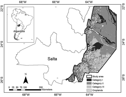
In the Province of Salta, the government created a specific agency or Executive Unit (EU) to carry out the FPP and build the zoning map required by the Forest Law. The EU included members of the government, the Administration of National Parks, the National Institute of Agricultural Technology (INTA), and local universities. The EU generated a zoning map with more than half a million hectares (of forests) in Category III, which were therefore available for deforestation. Even though the EU was a governmental agency, the government decided to disregard this map, apparently as a result of intense lobbying exercised by large-scale agricultural producers who believed the area under Category III was insufficient (Seghezzo et al., Citation2011). The government then commissioned a private consultancy to build a new map in which Category III was finally extended to 1.6 million hectares. In 2009, this map was finally approved as the official cartography of the FPP ().
Figure 1. Study area: the Chaco region in the province of Salta, Northwestern Argentina. Conservation categories from the zoning map in different tones of gray.
After more than ten years since the enactment of the Forest Law, it is time to take stock and assess to what extent the objectives of this law were actually accomplished. It also seems relevant to analyze how specific technical tools were used (and probably abused) during this period, and to ask ourselves about the role that these tools, together with theoretical and political approaches, could play in the enforcement of this law in the future. In this study, we address these issues by presenting a critical historical account of the enforcement of the Forest Law in the Province of Salta, Argentina, and discussing how some theoretical approaches, methodologies, and techniques could give policy makers tools to address some contentious topics in a technically accurate and socially inclusive way. We undertake an empirically based, qualitative assessment of the FPP that started in Salta as mandated by the Forest Law. We base our analysis on more than ten years of first-hand experience in the region, participant observation during the FPP, literature reviews, and information from different sources such as newspapers, magazines, websites, and reports from governmental or non-governmental organizations. We also present quantitative and semi-quantitative results obtained using multi-criteria decision-making (MCDM) methodologies and Geographic Information Systems (GIS) techniques, and discuss the potential of these methods for more democratic and sustainable policy making. Our main theoretical and methodological framework draws from land-change science and political ecology. These two disciplines are increasingly being applied to the study of human-environment relationships. Although they differ in their interests and explanatory power, they share a common understanding of the importance of applying a more contextualized approach to analyze the complexity of land change interactions (Turner II & Robbins, Citation2008). Our findings suggest that the FPP in Salta was questionable in terms of the deficient and arguably biased use of land-change science tools, and the lack of truly inclusive public participation. Contentious issues raised during the social debate that surrounded the enactment of the Forest Law were not properly addressed, the cartographic products of the FPP were disputed by virtually all parties, and the legitimacy of the entire process was highly contested.
Materials and methods
Study area: the chaco region in the province of salta
We focused our study on the portion of the ‘Chaco’ region located in the Province of Salta, in Northwestern Argentina (). Our study area covers almost 7 million hectares (an area bigger than the Republic of Ireland). It is part of the vast plain known as the ‘Gran Chaco’, a natural region shared by Bolivia, Paraguay, Brazil, and Argentina that harbors the second largest native forest of the South American continent after the Amazon (Bucher, Citation1982). The original landscape of the Chaco was described as a park-like land with patches of hardwood trees intermingled with natural grasslands (Bucher & Huszar, Citation1999). This profile was not entirely ‘natural’, since it had been partly constructed by local indigenous peoples through the use of fires intended to produce open grasslands that could support wildlife (Gordillo, Citation2004). This region is still rich in biodiversity, with valuable trees and other plants adapted to semi-arid conditions, and numerous species of mammals, birds, reptiles, and amphibians. Rainfall patterns in our study area range from 800 mm in the West to 550 mm in the East. This gradient defines the characteristics of the forests, from dense biomes with a variety of tree species in the West to fewer but also valuable tree species with larger proportion of undergrowth with patches of grasslands in the East. The agricultural potential of the region is high, especially in areas with well developed soils. Main crops cultivated in the region include soybean, corn, wheat, sorghum, and different types of beans, with more and more land devoted to livestock on natural and implanted pastures (Piccolo, Giorgetti, & Chávez, Citation2008).
The South American Chaco region has been strongly affected by deforestation and land use change (Gasparri & Grau, Citation2009; Volante et al., Citation2016). Main drivers of these processes have been variables such as the international prices of agricultural commodities (Fehlenberg et al., Citation2017), the introduction of genetically-modified soybean varieties, the expansion of non-tillage agriculture (Gasparri & Grau, Citation2009), changes in rainfall patterns (Grau, Aide, & Gasparri, Citation2005), the need to accommodate livestock displaced from central Argentina (Paruelo, Guerschman, & Verón, Citation2005), and the increasing ‘soy-ization’ of some provinces such as Salta (Delvenne, Vasen, & Vara, Citation2013). Deforestation due to the expansion of the agricultural ‘frontier’ has been more intense in the provinces of Santiago del Estero, Salta, Chaco, and Formosa (Volante & Seghezzo, Citation2018). The concept of agricultural frontier, or neoliberal agricultural frontier, is understood here as those export-oriented farming areas guided more by global demand and land privatization than by government policies or subsidies (Brannstrom, Citation2009). Only in the last two decades, deforestation in the Chaco region of the Province of Salta alone involved more than 1.2 million hectares, which represents about 20% of all its remaining native forestsFootnote5. Environmental problems associated with deforestation in the Chaco region included loss of biodiversity, reductions in the provision of ecosystem services such as water regulation or carbon capture (Paruelo et al., Citation2016), and the fragmentation of remnant forests (Piquer-Rodríguez et al., Citation2015). Deforestation also generated or intensified social-environmental conflicts, especially with small-scale agricultural producers and indigenous communities whose survival depends to a great extent on the habitat and resources provided by the forests (Seghezzo et al., Citation2017).
Theoretical and methodological framework
Our study approach was based on a combination of land-change science and political ecology. Political ecology is an increasingly relevant discipline in the field of social-environmental research that can help address complex human-nature interactions in a more comprehensive and nuanced way (Paulson, Gezon, & Watts, Citation2003). It combines ecological concerns with concepts from political economy (Blaikie & Brookfield, Citation1987). It was defined as the ‘theory and empirical research [that] address the condition and change of social/environmental systems, with explicit consideration of relations of power’ (Robbins, Citation2012, p. 20). As discussed in Walker (Citation2005, Citation2007), it is essential that the field of political ecology strikes a healthy balance between the collection of quantitative and empirical evidence of social-ecological change (the ‘ecology’ aspect) and the discussion of this evidence under a more political vision informed by concepts of power, social inequality, and environmental justice (the ‘politics’ aspect). If this effort is not made, political ecology research can become either ‘apolitical’ (Robbins, Citation2012) or ‘politics without ecology’ (Vayda & Walters, Citation1999), jeopardizing its usefulness as a tool for change and policy making (the ‘policy’ aspect) (Walker, Citation2006). Political ecology is particularly useful to put empirical results obtained with the tools of land-change science in a historical and political perspective, while retaining the ability to contribute to policy debate by engaging with policy makers and other relevant stakeholders, including marginalized collectives (Blaikie, Citation2008). The tools used by land-change science are essentially quantitative and they are mostly oriented to address global or regional human-environment dynamics. Land-change science is a broad discipline that involves a wide variety of methods and approaches, and it intends to document, monitor, and model land use, land cover, and land change in order to explain the relationships existing in coupled human-environment systems (Rindfuss, Walsh, Turner II, Fox, & Mishra, Citation2004). In our particular case study, we will discuss results obtained by applying two specific methods: (a) the Conflicts Assessment Model (CAM); and (b) the Land Matrix methodology. We will put these results in perspective by resorting to the analytical tools provided by political ecology.
The conflicts assessment model (CAM)
The Conflict Assessment Model (CAM) allows for the identification and evaluation of land use and tenure conflicts (Seghezzo et al., Citation2017). We developed this method as a scholarly contribution that could potentially be used during the FPP mandated by the Forest Law. The CAM combines MCDM and GIS methods (Zhang, Li, & Fung, Citation2012). The CAM builds on both ‘reductionist’ (top-down, quantitative and expert-led) and ‘conversational’ (bottom-up, qualitative and participatory) approaches, since it acknowledges the importance of local contexts, knowledges, and social perspectives while keeping the mathematical or statistical accuracy of quantitative methods (Bell & Morse, Citation2008). In the CAM, different variables related to land use (such as land tenure claims, land tenure regimes, and plot size) are mapped and superimposed on the zoning map. After that, different stakeholders (government officials, large-scale agricultural producers, scholars, environmental and social NGOs, among others) can be asked to assign subjective values to the perceived ‘intensity’ of the real or potential conflicts that arise from the combination of the different variables. This process can produce different conflict scenarios that can be used during negotiations to help decision makers and stakeholders construct more inclusive zoning maps. Information for the different layers was obtained from governmental and non-governmental organizations such as Salta’s provincial statistics office, the National Ministry of Science and Technology (MINCyT), the National Institute of Agricultural Technology (INTA), FUNDAPAZ (Fundación para el Desarrollo en Justicia y Paz; Foundation for the Development in Justice and Peace), and ASOCIANA (Acompañamiento Social de la Iglesia Anglicana en el Norte Argentino; Social Support from the Anglican Church in Northern Argentina). Maps were built at a scale of 1:2,900,000 using free GIS software (GvSIG and QGIS).
The land matrix methodology
We used the methodology developed by the Land Matrix, an international initiative that has been systematically identifying and monitoring large-scale land acquisitions (LSLA) as a way to promote transparency and responsibility in land-related decisions and investments (Anseeuw, Lay, Messerli, Giger, & Taylor, Citation2013)Footnote6. LSLA are commonly associated to ‘land grabbing’ and usually involve the purchase, lease, or concession of large areas of territory by foreign or domestic companies and investors (Borras, Kay, Gómez, & Wilkinson, Citation2012). As members of the Land Matrix Latin America Focal Point (LM-LAFP), we carried out a comprehensive plot-scale survey of LSLA in the Chaco region of the Province of Salta. We used the official cadastral database and additional data gathered from websites, newspapers, company newsletters, and interviews with local stakeholders.
Results and discussion
New map, old conflicts
Controversies on issues of production and conservation, two activities often considered as an irreconcilable dichotomy, were constant before, during, and after the passing of the Forest Law and the approval of the zoning map. Stakeholders participating in this debate usually included representatives of indigenous communities, associations of large and small-scale agricultural producers, social and environmental non-governmental organizations, national and provincial governments, enforcement agencies, politicians, and scholars. Debates focused on a number of contentious issues. The first and more divisive one was land tenure. Indigenous communities and small-scale producers saw the FPP as an opportunity to address long-standing land rights claims. However, although the Forest Law acknowledged the right of indigenous communities and small-scale producers to their ancestral territories, the existence of land claims was not an explicit criterion to build zoning maps (see ). Land conflicts were sometimes exacerbated by LSLA, particularly those in Categories I and II. This is not surprising since the main intention of LSLA is typically agriculture. Therefore, as also shown in other parts of the world, they usually lead to deforestation, land use change (Messerli, Giger, Dwyer, Breu, & Eckert, Citation2014), water appropriation (Rulli, Saviori, & D’Odorico, Citation2013), and social-environmental conflicts (Borras Jr. & Franco, Citation2013). A second contentious issue during the FPP in Salta was the degree and quality of public participation. The Forest Law established that public participation was indispensable during FPPs. However, without specific guidelines, participation was merely a formality, and it was unable to guarantee the free, prior, and informed consent of the communities affected (Hanna & Vanclay, Citation2013). Participation protocols were only established in 2015 by national authorities, but their correct implementation has not yet been evaluated in public hearings conducted by provincial administrations. Decisions made during public hearings were not binding and therefore the opinions and concerns of disempowered minorities were never really taken into account (Aguiar et al., Citation2018). Thirdly, the area with forests in Category III was particularly contentious, and virtually no one was happy with the final version of the zoning map. During the FPP, a variety of proposals had been mobilized by different stakeholders, with the area under Category III ranging from zero to virtually all remaining native forests (see more details in Seghezzo et al., Citation2011). Even though the approved zoning map allowed the deforestation of a significant proportion of remaining forests (more than one and a half million hectares), it was not welcomed by all large-scale producers, particularly those whose land fell under Categories I and II. These producers lobbied the government to allow for the entire or partial ‘re-categorization’ of their lands into Category III in order to qualify for deforestation and agricultural production. In 2010, by means of a provincial decree, the government allowed just that. About 150,000 hectares were then re-categorized at the request of title-holders after a relatively simple administrative procedure devoid of any genuine public participation (A. Leake, López, & Leake, Citation2016). According to official estimates, more than 30,000 hectares have been cleared in re-categorized areas since thenFootnote7. Due to the pressure exerted by environmental NGOs and other organizations, who saw this procedure as unconstitutional, re-categorizations were eventually bannedFootnote8.
In 2014, five years after the approval of the zoning map, the government launched a roundtable to update it, as requested by the Forest Law. As a way to prevent conflicts and facilitate social consensus, different stakeholders were invited to participate. Some of the authors of this article were also invited, in their capacity as members of national research organizations and local universities. However, some peasant’s organizations and indigenous communities were excluded using questionable legal arguments, reducing the representativeness and therefore the social legitimacy of this initiative, as observed for other participatory spaces in Latin America by Durand, Figueroa, and Trench (Citation2014). In a clear violation of the mandate and spirit of the Forest Law, the government made clear from the very first meeting that the only acceptable changes to the zoning map were the validation of all previous re-categorizations and the legalization of the more than a quarter million hectares that were illegally cleared since 2007Footnote9. Objections raised by several participants were directly ignored, de facto excluding them from the decision-making process and therefore undermining the democratic character of the roundtable (Chambers, Citation2003; Peterson, Citation2011). To appease some of the criticisms, the government’s new proposal included the definition of additional conservation areas and ecological corridors. However, these areas were simply superimposed as ‘transparent’ layers on the existing zoning map, and its implementation by land owners would be only voluntary. The zoning map was still ‘under review’ by the time we were writing the final version of this article (March 2019)Footnote10.
Land conflicts
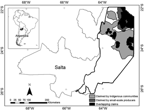
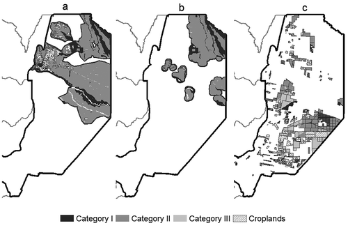
From the results in , it can be estimated that combined land claims by indigenous communities and small-scale producers amount to almost 3 million hectares, which is 41.7% of the study area (see also ). Most of the claims relate to lands that are either in private hands (71%) or owned by the State (26%) (Seghezzo et al., Citation2017). Estimations made with data in show that land claims are highly asymmetrical, since indigenous communities have claims over 92.2% of all disputed land, while this percentage is only 41.4% for small-scale agricultural producers (33.7% are overlapping claims). Some small-scale producers have land rights over small plots of land, usually much less than needed to sustain their livelihoods, but the situation of indigenous communities is more dramatic, since communal land owned by them is less than 1% of the study area. The government argued during the FPP that all land conflicts were lumped together under Category II, a category they referred to as ‘social yellow’. In this way, according to the government’s argument, the precautionary principle was honored and contested territories were protected from further deforestation. Yet from the data in it can be calculated that 75.6% of the claimed area fell under this category, with land claims present in all three conservation categories, including 8.9% in already deforested areas (for illustration purposes see , Maps a and b). Besides, Category II is far from safe from deforestation. As shown by Volante and Seghezzo (Citation2018), the percentage of deforestation in protected zones (Categories I and II) remained higher than in non-protected zones (Category III) long after the approval of the zoning map. Moreover, indigenous communities and small-scale producers do not necessarily agree on assigning a single conservation category to their lands, with some representatives even arguing that everything should be categorized green (Category III), since that would leave them with more options to freely govern their territories, as they have been doing for hundreds and even thousands of years. In summary, despite the availability of spatially-explicit information on land tenure claims, neither the original FPP nor the roundtable that is currently reviewing the zoning map made any significant progress towards securing land rights in contested territories. No measures were taken so far to address land conflicts, not even those perceived as having high or very high intensity by all stakeholders consulted (more details on different land conflict scenarios in Seghezzo et al., Citation2017).
Table 2. Area under different categories of the zoning map in the study area. LSLA: large-scale land acquisitions; ha: hectares.
Figure 2. Area claimed by indigenous communities and small-scale agricultural producers in the study area.
Land acquisitions
LSLA identified during our study in the period 2000–2018 (120 deals) are shown in . The area concerned covers more than 1.5 million hectares, which represents 22.6% of the study area (see also ). Domestic investors accounted for 92% of the LSLA, while the remaining 8% was acquired by international investors from countries such as the United States, Uruguay, the Netherlands, Luxemburg, France, and Spain, among others. Land deals detected were intended to develop agriculture (39%), cattle ranching (37%), or both (24%), and they would all therefore entail some degree of deforestation. A significant proportion of the deals (48.3%, 58 deals) was associated to one or more types of social-environmental conflicts such as land disputes or illegal displacements.
Figure 3. Large-scale land acquisitions (LSLA) identified in the study area in the period 2000–2018 (120 deals).
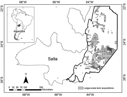
As shown in (see also , Map c, for illustration purposes), only about a third of the area associated to land deals (29.8%) corresponds to Category III, with 39.0% in Category II. It seems that investors are only avoiding land under Category I (4.3% of the area associated to land deals), but this is probably because most of it is already under some kind of legal protection or because it is located in rather inaccessible or remote areas, and not because of the deterrent effect of the zoning map. It is important to highlight that investment patterns, and therefore the spatial location of land acquisitions, did not significantly change after the passing of the Forest Law and the approval of the zoning map, as was also the case with deforestation rates in protected (yellow and red) zones, as shown by Volante and Seghezzo (Citation2018). These figures suggest that investors either ignore the restrictions over Category II or believe this category is somehow open for business and implicitly for deforestation. This investor behavior could be explained, at least in part, by a government initiative to authorize so-called ‘silvopastoral systems’ in Category II and somehow relax the ban for deforestation in those areasFootnote11. Silvopastoral systems are a diverse range of methods that combine agricultural production and cattle ranching with the preservation of the structure and functionality of forests and its components. Silvopastoral systems could be important for addressing and mitigating some of the environmental problems created and/or exacerbated by commercial agricultural in the subtropical and temperate zones of South America (Peri, Dube, & Varella, Citation2016). Contrary to conventional forestry, intensive cattle ranching, and crop monocultures, well-managed silvopastoral systems are said to diversify farm income, increase the resilience of local farmers, preserve biodiversity, and provide a number of additional social and environmental benefits. The government initiative to authorize silvopastoral systems was controversial. On the one hand, large-scale producers disapproved of the alleged complexity and low profitability of these systems, asking for the outright re-categorization of large tracts of land under Category II into Category III. On the other hand, environmental groups argued that silvopastoral systems were hardly compatible with a meaningful conservation of native forests. Whatever the case might be, it would be extremely difficult for short-staffed, underfunded government agencies to monitor and control good silvopastoral practices over the area intended to be covered by these systems. We believe that while silvopastoral systems could be attractive for the region (even for some areas under Category II), a better elucidation of their long-term economic profitability is required. More research is also needed on the sustainability of silvopastoral practices at both farm and landscape level, and on specific topics such as the regeneration of trees and shrubs under local conditions (Chará et al., Citation2019; Jose, Walter, & Kumar, Citation2019; Peri et al., Citation2016; Soler, Pastur, Peri, Lencinas, & Pulido, Citation2013).
Figure 4. Conservation categories of the zoning map superimposed to land claims by indigenous communities (Map a), land claims by small-scale agricultural producers (Map b), and large-scale land acquisitions (LSLA) (Map c).
Is there a role for land-change science and political ecology in policy making?
It is startling that two highly sensitive variables such as land tenure conflicts and LSLA have not been included in the Forest Law and were therefore not taken into account in the construction of the zoning map in Salta. The information we used to build was officially submitted to the government in 2008 by representatives of several indigenous peoples in order to support their territorial claims. However, it was only marginally considered to build the first zoning map, although part was allegedly used as the basis for the ‘social yellow’ category. As far as we know, it is also being ignored in the revision process currently in progress. Data on LSLA shown in have been compiled more recently, and could not have been used at that time. This information, however, with a detailed methodological description, was officially submitted as a voluntary contribution to the roundtable during the revision of the zoning map. Nevertheless, it has not been acknowledged so far during that revision, most likely because this information would undermine the dominant position of large-scale agricultural producers. Our contention was that lands that experienced LSLA at any moment during or after the FPP should stick to their conservation category even if this implied fines or forest restoration. It is clear that a change of ownership does not create any additional deforestation rights, and the State should be very vigilant to detect those who contravene the zoning map and punish them accordingly. Paradoxically, an updated LSLA database is a good indicator of the willingness of investors to engage in land cover change and it can therefore be used by enforcing agencies to focus their controlling efforts.
This is not to say that quantitative data cannot be manipulated to serve vested interests. During the FPP in Salta, some large-scale agricultural producers tried to base the zoning map on simple and apparently neutral variables such as terrain slope or soil quality, as a way to maximize the area available for deforestation while disregarding other less easily quantifiable criteria such as the intrinsic value assigned to the forest by indigenous communities. Significant biases can result if the values, ideologies, and assumptions hidden behind the selection of some of the parameters used in spatially-explicit models are not made clear, since land-change science tools are not a neutral application of scientific knowledge to social-environmental issues (Turner II & Robbins, Citation2008). The same is true for some participatory processes that are conducted by bureaucratic structures and formal institutions focusing on a loosely defined notion of ‘efficiency’ but without proper attention to power asymmetries and local knowledge (Barnaud & Van Paassen, Citation2013; Cooke & Kothari, Citation2001). Both technical tools and participatory processes can be hijacked by elites and powerful actors as a way to legitimize their positions, sometimes by presenting these methods as neutral and objective instruments that are beyond political struggles (Durand et al., Citation2014; White, Citation1996; Williams, Citation2004). As pointed out by Robbins (Citation2001), the use of quantitative tools is not always instrumental in reducing the contentiousness of land use planning and, in some cases, it can be just another technocentric way of perpetuating power inequalities and social injustices. Besides, land use maps made only by ‘experts’ without the open participation of local dwellers do not tell the full story and cannot be used as the sole way to understand and govern complex issues such as deforestation and land use change (Geist & Lambin, Citation2002; Sletto, Citation2009). So, even though land-change science tools and participatory processes can be very valuable for policy making, caution should be exercised whenever decisions are taken at the interface between science, institutions, knowledge, and power (Stringer et al., Citation2006). Based on our experience in Salta, we believe that a combination of land-change science (including MCDM methodologies) and political ecology can help reveal and revalue local subjectivities that might be buried under the uncritical or biased use of quantitative data and geographic information. Since different stakeholders have different perspectives, ideologies, and interests, they can interpret the same quantitative information in completely different ways. Therefore, subjectivity becomes an essential component of the process and not just an unwanted distortion that needs to be minimized by allegedly objective technical tools.
Concluding remarks
Assessing whether or not a complex piece of legislation such as the Forest Law fulfilled its expectations is difficult, especially because those expectations were not really clear from the beginning. In Salta, it seems evident that the law alone was unable to ensure the conservation and stability of all remaining native forests and the preservation of the livelihoods of the people living in and off them. A decade after the passing of the Forest Law, provincial governments are still unable or unwilling to stop illegal clearings, and deforestation in sensitive areas continues unabated. As extensively discussed in Volante and Seghezzo (Citation2018), reductions in the region’s overall deforestation rates cannot be safely attributed to the enforcement of the Forest Law but to other, more global variables such as prices of international commodities, political aspects, spatial constraints, judiciary interventions, export regulations, exchange rates, and the level of taxation of agricultural products, among others. Disputes among different stakeholders on the issues of deforestation and land use change are still defined by asymmetric power relations and different visions of development, while conflicts over land use and tenure persist. In this context, the enforcement of the Forest Law was far from optimum and, especially in the eyes of indigenous communities and small-scale agricultural producers, and judging by the opinion of scholars, environmentalists, and social activists, it cannot be considered a success.
It seems also clear that the Forest Law was an unprecedented breakthrough in the way the State addressed the issue of native forests, and it was instrumental in promoting a much-needed societal debate on the protection of native forests and local livelihoods. However, in order to be relevant for more socially inclusive policy making, FPPs need to be validated by all actors, particularly those who bear most of the consequences of deforestation and land use change, and benefit the least from the expansion of neoliberal agricultural frontiers.
Results presented in this article suggest that contentious issues raised during the debate surrounding the Forest Law could have been better addressed by the unbiased and technically sound use of a number of relatively simple quantitative or semi-quantitative land-change science techniques and readily available spatially-explicit data. We acknowledge the fact that quantitative methods are also prone to be co-opted by powerful actors as a way to validate and legitimize their interests and ideological positions. Therefore, whether the use of these tools will automatically lead to more fair and sustainable land use depends on a multiplicity of factors, among which political aspects retain paramount importance. It can be argued, however, that disempowered minorities could better defend their rights by promoting the unbiased use of such tools and demanding their worldviews to be fully included in socio-technical deliberative processes.
Our contention is that land-change science methodologies and political ecology should certainly play a role in land planning processes, bearing in mind that, as our case study illustrates, mapping techniques and public participation methods have many advantages but they can also be misused. An open debate is needed about key issues like who sets the decision-making agenda, who can and should participate, who chooses zoning criteria and monitoring variables, and who can force renegotiation and rezoning, among others. A balanced combination of land-change science and political ecology can help reveal the assumptions and the asymmetries involved in multi-stakeholders platforms and can be useful to improve the fairness of decision-making processes and the sustainability of social-environmental governance in agricultural frontiers such as the Chaco region in the Province of Salta and beyond.
Disclosure statement
No potential conflict of interest was reported by the authors.
Additional information
Funding
Notes
1. See: http://gestionurtubey.wordpress.com/2007/12/10/discurso-y-promesas-de-urtubey-al-asumir-el-gobierno-de-salta/(Last accessed 16 December 2018).
2. Press release by Greenpeace, Salta, 7 December 2007. Last accessed 16 March 2019.
3. Newspaper ‘Página 12’, Buenos Aires, Argentina, 30 June 2008. Last accessed 16 March 2019.
4. Usually referred to as criollos to highlight their cultural origin and European descent. The size of their plots is highly variable (from 300 to 3000 hectares), the main source of labor is usually the family, and access to capital is relatively low.
5. Data from: www.monitoreodesmonte.com.ar (Last accessed 12 March 2019).
6. More on the Land Matrix at: https://landmatrix.org/en/(Last accessed 18 January 2019).
7. See: https://www.agn.gov.ar/informes/implementacion-de-la-ley-26331-de-presupuestos-minimos-de-proteccion-ambiental-de-bosques (Last accessed 16 March 2019).
8. See: https://www.vidasilvestre.org.ar/sala_redaccion/?11700 (Last accessed 16 March 2019).
9. See: https://www.greenpeace.org/archive-argentina/es/noticias/El-gobierno-de-Salta-legalizara-los-desmontes-que-infrigen-la-Ley-de-Bosques/(Last accessed 16 March 2019).
10. According to the official website set up by the government to follow the revision process. Available at: http://y1000394.ferozo.com/# (Last accessed 16 March 2019).
11. Newspaper ‘El Tribuno’, Salta, Argentina, 16 January 2017. Last accessed 16 March 2019.
Related Research Data
References
- Aguiar, S., Mastrangelo, M.E., Collazo, M.A.G., Sans, G.H.C., Mosso, C.E., Ciuffoli, L., … Cáceres, D. (2018). ¿Cuál es la situación de la Ley de Bosques en la Región Chaqueña a diez años de su sanción? Revisando su pasado para discutir su futuro [What is the status of the Forest Law in the Chaco Region ten years after its enaction? Reviewing its past to discuss its future]. Ecología Austral, 28(2), 400–417. In Spanish
- Anseeuw, W., Lay, J., Messerli, P., Giger, M., & Taylor, M. (2013). Creating a public tool to assess and promote transparency in global land deals: The experience of the land Matrix. Journal of Peasant Studies, 40(3), 521–530.
- Barnaud, C., & Van Paassen, A. (2013). Equity, power games, and legitimacy: Dilemmas of participatory natural resource management. Ecology and Society, 18(2), 21.
- Bell, B., & Morse, S. (2008). Sustainability indicators: Measuring the immeasurable? London, UK: Earthscan Publications Ltd.
- Blaikie, P.M. (2008). Epilogue: Towards a future for political ecology that works. Geoforum, 39, 765–772.
- Blaikie, P.M., & Brookfield, H. (Eds.). (1987). Land degradation and society. London, UK: Methuen.
- Borras, J.S., Kay, M., Gómez, C., & Wilkinson, J. (2012). Land grabbing and global capitalist accumulation: Key features in Latin America. Canadian Journal of Development Studies/Revue Canadienne D’études Du Développement, 33(4), 402–416.
- Borras Jr., S.M., & Franco, J.C. (2013). Global land grabbing and political reactions ‘from below’. Third World Quarterly, 34(9), 1723–1747.
- Brannstrom, C. (2009). South America’s neoliberal agricultural frontiers: Places of environmental sacrifice or conservation opportunity? Ambio, 38(3), 141–149.
- Bucher, E.H. (1982). Chaco and Caatinga – South American arid savannas, woodlands and thickets. In B.J. Huntley & B.H. Walker Eds., Ecology of tropical savannas (Ecological Studies, Vol. 42, pp. 48–79). Berlin: Springer-Verlag, New York, NY: Heidelber
- Bucher, E.H., & Huszar, P.C. (1999). Sustainable management of the Gran Chaco of South America: Ecological promise and economic constraints. Journal of Environmental Management, 57, 99–108.
- Chambers, S. (2003). Deliberative democratic theory. Annual Review of Political Science, 6, 307–326.
- Chará, J., Reyes, E., Peri, P., Otte, J., Arce, E., & Schneider, F. (2019). Silvopastoral systems and their contribution to improved resource use and sustainable development goals: Evidence from Latin America. Cali, Colombia: Centre for Research on Sustainable Agriculture (CIPAV), Agri Benchmark and FAO.
- Cooke, B., & Kothari, U. (Ed.). (2001). Participation: The new tyranny? London, UK: Zed Books.
- Delvenne, P., Vasen, F., & Vara, A.M. (2013). The “soy-ization” of Argentina: The dynamics of the “globalized” privatization regime in a peripheral context. Technology in Society, 35, 153–162.
- Durand, L., Figueroa, F., & Trench, T. (2014). Inclusion and exclusion in participation strategies in the Montes Azules biosphere reserve, Chiapas, Mexico. Conservation and Society, 12(2), 175–189.
- Fehlenberg, V., Baumann, M., Gasparri, N.I., Piquer-Rodriguez, M., Gavier-Pizarro, G., & Kuemmerle, T. (2017). The role of soybean production as an underlying driver of deforestation in the South American Chaco. Global Environmental Change, 45, 24–34.
- García-Collazo, M.A., Panizza, A., & Paruelo, J.M. (2013). Ordenamiento Territorial de Bosques Nativos: Resultados de la Zonificación realizada por provincias del Norte argentino [Forest Planning Processes: results of the zoning carried out by provinces of the Argentine North]. Ecología austral, 23(2), 97–107. In Spanish.
- García-López, G.A., & Arizpe, N. (2010). Participatory processes in the soy conflicts in Paraguay and Argentina. Ecological Economics, 70, 196–206.
- Gasparri, N.I., & Grau, H.R. (2009). Deforestation and fragmentation of Chaco dry forest in NW Argentina (1972–2007). Forest Ecology and Management, 258(6), 913–921.
- Geist, H.J., & Lambin, E.F. (2002). Proximate causes and underlying driving forces of tropical deforestation. BioScience, 52(2), 143–150.
- Gordillo, G. (2004). Landscapes of devils: Tensions of place and memory in the Argentinean Chaco. Durham, NC: Duke University Press.
- Grau, H.R., Aide, T.M., & Gasparri, N.I. (2005). Globalization and soybean expansion into semiarid ecosystems of Argentina. Ambio, 34(3), 265.
- Hanna, P., & Vanclay, F. (2013). Human rights, indigenous peoples and the concept of free, prior and informed consent. Impact Assessment and Project Appraisal, 31(2), 146–157.
- Jose, S., Walter, D., & Kumar, B.M. (2019). Ecological considerations in sustainable silvopasture design and management. Agroforestry Systems, 93(1), 317–331.
- Leake, A., López, O.E., & Leake, M.C. (2016). La deforestacion del Chaco salteño 2004–2015 [Deforestation in the Chaco region of Salta 2004–2015]. Salta, Argentina: SMA Ediciones. In Spanish.
- Messerli, P., Giger, M., Dwyer, M.B., Breu, T., & Eckert, S. (2014). The geography of large-scale land acquisitions: Analysing socio-ecological patterns of target contexts in the global South. Applied Geography, 53, 449–459.
- Paruelo, J. M., Guerschman, J. P., & Verón, S. R. (2005). Expansión agrícola y cambios en el uso del suelo [Agricultural expansion and land use changes]. Ciencia Hoy, 15(87), 14–23. In Spanish.
- Paruelo, J.M., Texeira, M., Staiano, L., Mastrángelo, M., Amdan, L., & Gallego, F. (2016). An integrative index of ecosystem services provision based on remotely sensed data. Ecological Indicators, 71, 145–154.
- Paulson, S., Gezon, L.L., & Watts, M. (2003). Locating the political in political ecology: An introduction. Human Organization, 62, 205–217.
- Peri, P.L., Dube, F., & Varella, A. (Eds.). (2016). Silvopastoral systems in Southern South America. London, UK: Springer.
- Peterson, N.D. (2011). Excluding to include: (Non)participation in Mexican natural resource management. Agriculture and Human Values, 28, 99–107.
- Piccolo, A., Giorgetti, M., & Chávez, D. (2008). Zonas agroeconómicas homogéneas Salta-Jujuy [Homogeneous agro-economic zones Salta-Jujuy]. Salta, Argentina: INTA (Instituto Nacional de Tecnología Agropecuaria). In Spanish.
- Piquer-Rodríguez, M., Torella, S., Gavier-Pizarro, G., Volante, J., Somma, D., Ginzburg, R., & Kuemmerle, T. (2015). Effects of past and future land conversions on forest connectivity in the Argentine Chaco. Landscape Ecology, 30(5), 817–833.
- Rindfuss, R.R., Walsh, S.J., Turner II, B.L., Fox, J., & Mishra, V. (2004). Developing a science of land change: Challenges and methodological issues. PNAS, 101(39), 13976–13981.
- Robbins, P. (2001). Fixed categories in a portable landscape: The causes and consequences of land-cover categorization. Environment and Planning A, 33, 161–179.
- Robbins, P. (2012). Political ecology: A critical introduction (2nd ed.). Malden, MA: Wiley-Blackwell (Critical introductions to geography).
- Rulli, M.C., Saviori, A., & D’Odorico, P. (2013). Global land and water grabbing. Proceedings of the National Academy of Sciences, 110(3), 892–897.
- Seghezzo, L., Venencia, C., Buliubasich, E.C., Iribarnegaray, M.A., & Volante, J.N. (2017). Participatory, multi-criteria evaluation methods as a means to increase the legitimacy and sustainability of land use planning processes. The case of the Chaco region in Salta, Argentina. Environmental Management, 59(2), 307–324.
- Seghezzo, L., Volante, J.N., Paruelo, J.M., Somma, D.J., Buliubasich, E.C., Rodríguez, H.E., … Hufty, M. (2011). Native forests and agriculture in Salta (Argentina): conflicting visions of development. The Journal of Environment & Development, 20(3), 251–277.
- Sletto, B.I. (2009). “We drew what we imagined”. Participatory mapping, performance, and the arts of landscape making. Current Anthropology, 50(4), 443–476.
- Soler, R., Pastur, G.M., Peri, P., Lencinas, M.V., & Pulido, F. (2013). Are silvopastoral system compatible with forest regeneration? An integrative approach in southern Patagonia. Agroforestry Systems, 87(6), 1213–1227.
- Stringer, L.C., Dougill, A.J., Fraser, E., Hubacek, K., Prell, C., & Reed, M.S. (2006). Unpacking “participation” in the adaptive management of social-ecological systems: A critical review. Ecology and Society, 11, 39.
- Turner II, B.L., & Robbins, P. (2008). Land-change science and political ecology: Similarities, differences, and implications for Sustainability Science. Annual Review of Environment and Resources, 33, 295–316.
- Vallejos, M., Volante, J.N., Mosciaro, M.J., Vale, L.M., Bustamante, M.L., & Paruelo, J.M. (2015). Transformation dynamics of the natural cover in the dry Chaco ecoregion: A plot level geo-database from 1976 to 2012. Journal of Arid Environments, 123, 3–11.
- Vayda, A.P., & Walters, B.B. (1999). Against political ecology. Human Ecology, 27, 167–179.
- Volante, J.N., Mosciaro, M.J., Gavier-Pizarro, G.I., & Paruelo, J.M. (2016). Agricultural expansion in the Semiarid Chaco: Poorly selective contagious advance. Land Use Policy, 55, 154–165.
- Volante, J.N., & Seghezzo, L. (2018). Can’t see the forest for the trees: Can declining deforestation trends in the Argentinian Chaco region be ascribed to efficient law enforcement? Ecological Economics, 146, 408–413.
- Walker, P.A. (2005). Political ecology: Where is the ecology? Progress in Human Geography, 29(1), 73–82.
- Walker, P.A. (2006). Political ecology: Where is the policy? Progress in Human Geography, 30(3), 382–395.
- Walker, P.A. (2007). Political ecology: Where is the politics? Progress in Human Geography, 31(3), 363–369.
- White, S.C. (1996). Depoliticizing development: The uses and abuses of participation. Development in Practice, 6(1), 6–15.
- Williams, G. (2004). Evaluating participatory development: Tyranny, power and (re)politicisation. Third World Quarterly, 25(3), 557–578.
- Zhang, Y.J., Li, A.J., & Fung, T. (2012). Using GIS and multi-criteria decision analysis for conflict resolution in land use planning. Procedia Environmental Sciences, 13, 2264–2273.