
ABSTRACT
Landslides, one of the most common mountain hazards, can result in enormous casualties and huge economic losses in mountainous regions. In order to address the landslide hazards effectively, the geological society is required not only to develop in-depth understanding of landslide mechanism but also to quantify its associated risk. In this article, landslide risk assessment is categorised into two types, hard and soft risk assessments, and reviewed separately. The hard approach focuses on the mechanics and numerical simulations of individual landslides, subsequent consequences, and their uncertainty quantifications and probabilistic analyses while the soft approach explores the quantification of disaster risk components such as hazard and vulnerability at different scales of concern. It is hoped that this article can serve as a time capsule to link the preceding and following of landslide risk assessments and shed some light on future studies.
1. Introduction
Landslide was defined as the movement of a mass of rock, earth or debris down a slope, with the qualification that landslides are not confined to the land nor sliding failure (Cruden Citation1991). It also includes falls, flows and topples (Varnes Citation1978) and has been witnessed on the continental shelf (Twichell et al. Citation2009) and even on Mars (Quantin et al. Citation2004). Landslide moves at very different rates from creeping (mm/year) to rapid (10s–100s km/hour) and at different scales from localised slumps (<1 m3) to a whole mountain collapses (>108 m3) (Weidinger et al. Citation2014). At the same time, landslide can be triggered by many factors, such as rainfall, earthquake, snowmelt and anthropogenic activities. Landslides have caused enormous casualties and huge economic losses, especially in mountainous regions. It has been reported that only between 2004 and 2016, a total of 55,996 fatalities in nearly 5,000 landslide events and economic loss of about 3.56 billion USD were estimated (Froude and Petley Citation2018). To mitigate landslide hazards effectively, it requires a better understanding of the landslide mechanism and its associated risk.
Landslide risk assessment can be categorised into two types: (a) hard risk assessment approach and (b) soft risk assessment approach. The hard approach involves mechanics and numerical simulations of individual landslides, subsequent consequences, and their uncertainty quantifications and probabilistic analyses. In contrast, the soft approach involves conceptual definitions of risk for landslides in a region as well as the subsequent expert-based analyses and statistical analyses. Recently, the soft approach started to integrate with hard approach by engaging the hazard formation and movement mechanism in the analysis and adopting numerical simulation in its assessment. Historically, there seems to be little overlap between these two approaches. Therefore, the historical developments for these two approaches are reviewed separately, starting from the soft approach, then the hard approach. For the soft approach, the scope is broadened to “mountain hazards risk assessment” to encompass landslides, debris flows, flash floods, etc. For the hard approach, the scope of the review is limited to soil slope failures.
Recent advances in risk assessment provide systematic frameworks to improve landslide management. The landslide management has started shifting its focus from landslide control to landslide risk control. During this process, risk assessment has become essential in addressing uncertainty inherent in landslide hazards. Tracing the original concept of risk, this article reviews the major advances in both the soft and hard risk assessment approaches of landslides. Challenges in the future study of landslide risk assessment are also discussed.
2. Soft approach – mountain hazards risk assessment
Mountain hazards refer to natural hazards that occur in mountainous areas which threaten human society, ecological environment, and natural resources (Cui, Deng, and Wang Citation2019). This section focuses on such mountain hazards as landslides, debris flows, and flash floods. In the past decade, natural hazards have caused more than 700,000 deaths and more than 1.4 million people injured globally. About 140 million people have been displaced. More than 1.5 billion people have been affected, and economic losses have exceeded 1.3 trillion US dollars (UNDRR Citation2016). Among all types of disasters, the widespread and frequent mountain disasters contributed to a significant portion of the casualties and economic losses globally (Cui, Deng, and Wang Citation2019).
This section firstly chronically arranged the development of mountain hazards risk assessment into four phases as pre-1990, 1990–2005, 2005–2015, and post-2015, according to the milestones for international community engagement in disaster risk reduction. Then, the disaster risk assessment of mountain hazards (e.g. landslides, debris flows, flash floods) was reviewed in terms of its concept, theory, and methodology chronologically in these four phases. In general, although hazard (H) and vulnerability (V) were still two major components, the concept of disaster risk assessment became richer and more comprehensive. At the same time, with science and technology advances, the methods to assess mountain hazard risks and their development at each phase were summarised in this section. In the future study, with new challenges such as climate change, social and financial crises, vulnerabilities, and social inequalities, the disaster risk assessment should focus more on the fundamental research of hazard mechanisms and also on new forms of the complex, compound and cascading risks. Meanwhile, with deep roots in natural science, the disaster risk assessment should also integrate social science as an evidence-based tool for more solid risk-informed decision-making in disaster risk management.
The idea that risks describe the possibility of loss or injury can be traced to a Greek navigation word in Homer’s Rhapsody of the Odyssey with the meaning of “cliff or reef” when passing the Sirens, Scylla, and Charybdis during navigation (Skjong Citation2005). Later, this Greek word stimulated inspirations for the Latin word resicum, risicum, and riscus with the same meaning of “cliff and reef” and also as a metaphor to describe “the dangers to avoid in the sea” (Skjong Citation2005; Boholm Citation2015). Subsequently, with the earliest sources dating to the thirteenth century, many European terms, such as the noun of risco in Italian, risque in French, riesgo in Spanish, took up this Latin word as the point of origins and provided the direct etymology roots for the English word “risk” (Collins Citation2015; Boholm Citation2015).
The concept of risk differs in various fields, including natural science, business, health, psychology, insurance, and safety. In the aspect of natural hazards, the United Nations Office for Disaster Risk Reduction (UNDRR) officially defined the disaster risk in 2021 as “The potential loss of life, injury, or destroyed or damaged assets which could occur to a system, society or a community in a specific period of time” (UNDRR Citation2021). This section reviews the progress of risk assessment theory and methods related to mountain hazards under the changing concept of disaster risk in the international communities in four phases since the 1990s.
2.1. Milestones for international community engagement in disaster risk reduction
Encountering the unacceptable and rising losses triggered by natural hazards, international communities have taken concerted actions on hazard mitigation and disaster risk reduction with intentions to reduce the impacts of natural hazards since the last century ().
Figure 1. Milestones for international community engagement in disaster risk reduction.
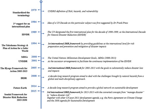
The United Nations (UN), as the largest international organisation in the world, has funded the United Nations Disaster Relief Office (UNDRO) in 1971, aiming to assist with disaster events in practice, including pre-disaster planning and technological developments for hazard mitigation (UNDRR Citation2019). In 1984, the president of the US National Academy of Sciences, Dr. Frank Press, in the keynote speech at the opening ceremony of the 8th World Conference on Earthquake Engineering, addressed that:
I believe there is great need, and much support can be found, to establish an International Decade of Hazard Reduction. This special initiative would see all nations joining forces to reduce the consequences of natural hazards.
In addition to the United Nations, several other influential programmes are also devoted to disaster risk reduction. For example, in 2010, a decade-long research programme, the Integrated Research on Disaster Risk (IRDR), was established by the co-sponsors of the International Science Council and the UNDRR to deal with the challenges brought by natural hazards, mitigate their impacts, and improve the related policy-making mechanisms from a global and multi-disciplinary approach. In 2012, the Future Earth was launched as a 10-year international research programme at the UN Conference on Sustainable Development (Rio + 20) to provide a global network of scientists, researchers, and innovators collaborating for a more sustainable planet.
At present, international frameworks and research programmes have prioritised the understanding of disaster risk in all its dimensions of exposures, vulnerabilities, and hazards for effective and efficient disaster risk management. It is recognized that the role of science and technology in DRR is to develop science-based risk knowledge and methodologies. In this regard, disaster risk assessment is all along provided an essential scientific tool for disaster risk reduction and risk-informed decision-making. The roadmap of disaster risk assessment is reviewed in the following section.
2.2. Phase 1: pre-1990s
In the field of natural hazards prevention, the concept of risk was earliest defined in 1979 in the document “Natural Disaster and Vulnerability Analysis” by the Office of the United Nations Disaster Relief Coordinator (UNDRO), a focal point in the UN system for disaster concerns and activities (UNDRO Citation1979). Based on relevant publications from UNDRO and UNESCO, this document proposed widely accepted definitions for disaster-related terminologies, for instance, natural hazard, vulnerability, risk, and elements at risk. This glossary provided future disaster risk research with theoretical groundwork in terminology definition. In this document, “risk” was defined as (UNDRO Citation1979)
The expected number of lives lost, persons injured, damage to property and disruption of economic activity due to a particular natural phenomenon, and consequently the product of specific risk and elements at risk.
Such process was the standardisation in assessment procedures from data acquisition to final analysis. However, limited by the development of Geographic Information Systems (GIS), the lengthy operations involved in this approach made it less feasible in practice. Stevenson (Citation1977) developed a landslide risk methodology based on hazard zonation in Tasmania. Eldeen (Citation1980) used the hazard map to study the risk of debris flow disaster and introduced the flood risk model to study debris flow risk. Hollingsworth and Kovacs (Citation1981) used the factor superposition method and scoring evaluation to calculate landslide risk, which provided the direction for debris flow risk assessment studies. Hansen (Citation1984) summarised four essential factors for debris flow risk assessment. In 1988, Liu (Citation1988) combined qualitative analysis with quantitative analysis, put forward a multi-factor comprehensive evaluation model of debris flow risk, and a series of risk assessment methods for debris flow of different scales.
2.3. Phase 2: 1990–2005
The 1990s was a remarkable decade for disaster risk reduction. The word “risk society” became a popular discourse (Giddens Citation1990; Beck, Lash, and Wynne Citation1992; Fell Citation1994) due to the growing concerns of environmental issues and global development during the period. Two sociologists, Ulrich Beck (British) and Anthony Giddens (German), developed the theory of risk society in the 1980s (Caplan Citation2000). The United Nations designated the 1990s as the International Decade for Natural Disaster Reduction (IDNDR), during which the United Nations Department of Humanitarian Affairs (UNDHA) in 1992 updated the glossary of agreed terms and specified risk as (UNDHA Citation1992)
Expected losses (of lives, persons injured, property damaged, and economic activity disrupted) due to a particular hazard for a given area and reference period. Based on mathematical calculations, risk is the product of hazard and vulnerability.
Henceforth, with additional consideration of vulnerability in risk, many researchers started to explore the relations among risk, hazard, and vulnerability and derived several risk equations (). Among these equations, the UNDHA (Citation1991) formulated the equation as R = H × V, where disaster risk (R) is a function not only of a hazard (H) but also of the vulnerability (V) of the impact area. This expression of risk became the fundamental risk equation for much of disaster research in the next two decades, although reserving minor differences in understanding and calculation of H and V, respectively.
Table 1. Concept model of risk assessment.
Among several methods for disaster risk assessment, indicator-based risk assessment took an instrumental role thereupon, primarily when assessing the disaster risk of a large area. The indicator-based approach adopted a similar concept to the Expert Evaluation Approaches in the 1990s. It looked for the disaster-fostering and triggering factors, as well as variables that influence the vulnerability of an element at risk. Different sets of indicators could be developed for each type of disaster and elements at risk to reflect their characteristics. The importance of indicator-based method had also been identified in the Hyogo Framework, as a key activity. The development of “systems of indicators of disaster risk and vulnerability at national and sub-national scales will enable policymakers to assess the impact of disasters on social, economic and environmental conditions and disseminate the results to decision-makers, the public and populations at risk.” (UNISDR Citation2005). The main limitations of the indicator-based risk assessment are the lengthy procedure and complexity of spatial information processes. With the advances in GIS technology in the 1990s, it overcame those limitations and became a technology driver for the advancement of landslide risk assessment during this period.
GIS techniques were widely adopted as a tool for spatial data analysis and graphic representation in many fields, including the risk assessment for natural hazards. The GIS-based risk assessment, as a particular interest, was discussed and practiced for many landslides and debris flows (e.g. Gupta and Joshi Citation1990; Carrara et al. Citation1991; Dhakal, Amada, and Aniya Citation1999; Van Westen Citation2000; Chau et al. Citation2004). Landslide and debris flow assessment relies much on the indicator-based methods, where environmental factors such as geology, slope gradient and aspect, elevation, soil geotechnical properties, vegetation cover, and triggering factors such as precipitation and earthquake intensity were adopted (e.g. Mark and Ellen Citation1995; Iverson, Schilling, and Vallance Citation1998; Guzzetti et al. Citation1999; Lin et al. Citation2002; Pallàs et al. Citation2004; Mondal, Mukherjee, and Maiti Citation2012; Ngadisih et al. Citation2014). In addition, several countries have developed guidelines or best practices related to landslides risk assessment and management as part of their national strategies to reduce losses and increase the sustainability of their critical infrastructure (AGS Citation2007; Spiker and Gori Citation2003; Porter and Morgenstern Citation2013). These guidelines provided engineers, geoscientists, and practitioners with a state-of-the-art document of their time related to the science and applied science on landslide risk. During this period, advances of GIS technology facilitated disaster risk visualisation and spatial representation, which exposed risk communication and understanding in a new light to promote practitioners in every industry to gain a deeper understanding and insights hidden in disaster risks. The limitations of this kind of assessment mainly rested in the indicator weight calculation and the lacked hazard mechanism.
2.4. Phase 3: 2005–2015
Two important studies were done in this period to review the landslide risk assessment. Hungr et al. (Citation2005) created a general framework for landslide risk assessment, while Corominas et al. (Citation2014) recommended the concepts and methodologies for the quantitative analysis of landslide hazard, vulnerability and risk at different spatial scales. This study summarises the developed quantified landslide risk assessment in two different approaches. The first approach relied on the development of probabilistic models. As quantitative risk estimation for geohazards is frequently achieved through the product of two macro-components: hazard and vulnerability of elements at risk. Uncertainty-based risk estimation involves the non-deterministic characterisation of all the macro-components of risk, by assigning probability distributions to the hazard and vulnerability or using statistical moments. Lacasse, Nadim, and Uzielli (Citation2007) reviewed the evaluation of slopes safety and realised that the deterministic approach fails to deal consistently with uncertainties. A quantitative framework for landslide risk assessment was then presented where the probabilistic approach, as a complement to the deterministic approach, allowed for hazard and risk assessment of slopes. Uzielli, Lacasse, and Nadim (Citation2009) contributed an uncertainty-based risk estimation method wherein the risk was calculated by Monte Carlo simulation. The non-deterministic characterisation of the risk components: hazard and vulnerability, were modelled as functions of intensity, where the intensity parameterises the damaging potential of the hazardous event. Eidsvig, Lacasse, and Nadim (Citation2009) illustrated the application of event tree analysis (ETA) to a rockfall risk analysis at the Aknes site in Norway. The ETA approach is especially useful for geotechnical problems that involve large uncertainties and can quantify hazard and risk, and indicate the most critical situations. Nadim and Liu (Citation2013) proposed a quantitative risk assessment model using Bayesian networks to estimate the risk for the buildings exposed to the threat of earthquake-triggered landslides. The approach included a sensitivity analysis to identify the optimum and appropriate risk reduction strategy from a multi-hazard perspective. Cepeda, Quan Luna, and Nadim (Citation2013) proposed a probabilistic procedure based on a Monte Carlo simulation for the probabilistic estimation of landslide runout extents and intensities in the areas where determining the rheological parameters based on back analyses was impossible. Liu et al. (Citation2015) proposed a three-level framework for multi-risk assessment where the risk was assessed from qualitative to semi-quantitative and quantitative, based on the impact of the potential hazards. A quantitative multi-risk assessment model based on Bayesian networks is introduced to both estimate the probability of triggering/cascade effects and model the time-variant vulnerability of a system exposed to multiple hazards.
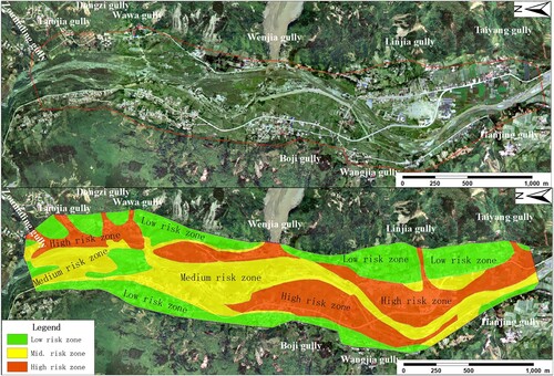
Besides using probabilistic models to achieve quantitative risk assessment, with the deepening understanding of the mechanism of mountain hazards such as landslide and debris flow, numerical simulation of disasters became possible (e.g. Iverson Citation2005; Jakob, Hungr, and Jakob Citation2005; Hungr and McDougall Citation2009; Sassa et al. Citation2010; Sanchez, Pastor, and Romana Citation2013; Ouyang et al. Citation2013; Pudasaini and Krautblatter Citation2014; Cascini et al. Citation2021). Hazard assessment started to combine indicator-based statistical analysis with numerical simulation. This type of method can depict the mobility and dynamic process of the disaster and the characteristics of debris flow or landslide ().
Figure 2. Hazard assessment of Qinping Town (Modified from Cui et al. 2015).
Vulnerability assessment also made significant progress in this period to support disaster risk assessment. In the 1990s, the vulnerability assessment method had transformed from qualitative evaluation or expert judgment to quantitative calculation (Liu, Muo, and Wang Citation2001). Scholars from Australia and the Alpine countries made an early effort to develop vulnerability matrices to assess the vulnerability of the elements at risk based on expert judgment (Leone, Asté, and Leroi Citation1996). Such assessment was qualitative, and the results could be somewhat subjective since the knowledge and experiences of the experts vary. To overcome this limitation, vulnerability matrices were developed as a vulnerability function made as an attempt. Vulnerability functions describe the relationship between the hazard intensity and the degree of damage to the elements at risk when subject to the hazard impact. Post-disaster survey data were used to correlate the disaster loss to disaster intensity, and the empirical relationship was plotted as a vulnerability curve or function using regression analysis (Fuchs, Heiss, and Hübl Citation2007; Jakob, Stein, and Ulmi Citation2012). Vulnerability curves are popular among practitioners because they directly connect the intensity of a process with the corresponding degree of loss, providing concrete quantitative results and translating potential events into monetary damage. However, this kind of assessment largely relies on the availability of disaster event data, such as the debris flow height and monetary damage per building. As such, the developed vulnerability function was very site-specific and hard to adopt universally. This is particularly true when the loss estimation includes life and economic damage since the standard to calculate such damage largely varies (Jonkman, Van Gelder, and Vrijling Citation2003; Winter and Bromhead Citation2012). Uzielli et al. (Citation2008) adopted the ISSMGE Glossary of Risk Assessment Terms definitions of vulnerability as “The degree of loss to a given element or set of elements within the area affected by a hazard … ” (http://www.engmath.dal.ca/tc32/). They proposed a methodology for quantitatively estimating the physical vulnerability of the built environment and population to landslides. The vulnerability function was defined as the product between landslide intensity and the susceptibility of vulnerable elements, including structures and persons. In addition to vulnerability curves (or functions), more recently, vulnerability indicators were employed to assess the physical vulnerability of buildings (e.g. Kappes, Papathoma-Köhle, and Keiler Citation2012; Thouret et al. Citation2014) and the landslide risk assessment on infrastructures such as highways attracted more attentions (Dorren et al. Citation2009; Pantelidis Citation2011). Researchers needed to select better indicators, more reliable weighting, and aggregation to achieve quantitative assessment (Fuchs et al. Citation2019).
In this period, advances in understanding hazard mechanisms and well-developed numerical simulation allowed scholars to conduct a dynamic-based hazard assessment. On the other hand, studies on the vulnerability function gave us more objective ways to connect the hazard process to the degree of damage of the elements at risk. In this way, site-specific risk assessment was transformed from qualitative to quantitative and subjective to objective.
2.5. Phase 4: post-2015
The high level of dependency of modern populations on critical infrastructure and networks allowed the impact of disasters to propagate through socio-economic systems. Where vulnerabilities overlapped and interacted, escalation points were used to create secondary effects more significantly than the primary event (e.g. Zhang, Zhang, and Huang Citation2014; Alexander and Pescaroli Citation2019). Therefore, both direct and indirect costs need to be considered when assessing the disaster risk (MacLeod et al. Citation2005). This series of disaster events was called cascading disasters or disaster chains. Pescaroli and Alexander (Citation2015) defined this type of event by the following statement:
Cascading effects are the dynamics present in disasters, in which the impact of a physical event or the development of an initial technological or human failure generates a sequence of events in human subsystems that result in physical, social or economic disruption.
Alexander (Citation2018) classified the magnitude scale of cascading disasters into five levels based on the magnitude and potential consequences. This qualitative approach required expert judgment on the escalation point during the chain of events, i.e. where cascades begin and end. At the regional scale, the quantitative assessment method adopted a complex network, Bayesian network, and uncertainty theory to calculate the probability between the adjacent disaster events (Guo et al. Citation2020; Deng et al. Citation2022). These methods could connect the diverse disaster events and related factors to calculate the probability of the occurrence of disaster events so that a quantitative hazard assessment of a series of disaster events could be conducted.
A more quantitative approach was made possible with the numerical simulation on the cascading disaster process at the local scale. Shen et al. (Citation2018) and Liu and He (Citation2018) presented a numerical model to simulate the landslide, barrier lake, and outburst disaster chain, which consists of several sub-models used for simulating the primary and secondary disaster transformation and movement. The study of topographic and entrainment effects on the transforming process between landslide and debris flow supported a more accurate prediction of hazard movement and associate risk (Guo et al. Citation2022). The numerical model assessed the occurrence of cascading disasters based on the triggering mechanism of each potential disaster in the cascading events instead of calculating the occurrence probability of secondary disaster.
For vulnerability assessment, despite the numerous studies on the physical vulnerability of elements at risk, such as buildings, there was still a gap concerning the interaction between the assessed element and natural processes. Scholars had made some attempts on this topic by using laboratory tests or theoretical analysis. For instance, Sturm et al. (Citation2018) used a scaled fan model, including building stocks, to capture the flow impact pressure on the walls and provided information on impact pressure and flow heights per building. It demonstrates that the importance of shielding effects in buildings vulnerability assessment as some of the buildings acted as protective shields for neighbouring buildings, while others might redirect the flow and increased the intensity for other buildings. Luo et al. (Citation2020) further assessed the building’s vulnerability to mass flows (such as landslides, debris flow, and flood) to investigate the interaction mechanisms between the mass flows and buildings using numerical simulation. That study provided a solid basis to develop building vulnerability models for such flow-like mass movements. In addition to buildings, transportation infrastructures such as roads are also important elements at risk for landslide. Assessing the safety of highway users that is threatened by mountain hazards is also a hot research topic (Zou et al. Citation2018; Macciotta et al. Citation2020; Zhang et al. Citation2021). Based on the recent summary of the pros and cons of the most used vulnerability assessment methods provided by Fuchs et al. (Citation2019), this review paper further included the method of “Vulnerability calculation” in .
Table 2. Review of existing methods for the assessment of physical vulnerability (modified from Fuchs et al. Citation2019).
2.6. Way forward
Climate change, biodiversity, social inequality, vulnerability, and other emerging global risk patterns have proposed new eras for disaster risk reduction and its associated issues. In this shifting risk landscape, as an essential tool for scientists in the disaster risk community, the risk assessment needs to focus on the following aspects.
Climate change, as the new driver of natural hazards, has posed new challenges on disaster risk reduction since it changes the disaster fostering environment and brought new characteristic of the disaster risk. Studies should address climate change-associated issues, such as extreme weather events and its impact on the disaster formation and occurrence, to deepen the understanding of cascading and complex risks and form a systematic theory for comprehensive and dynamic disaster risk assessment.
There should be an emphasis on the fundamental research of disaster mechanisms. Climate changes have brought new characteristics to natural hazards, such as increased frequency and intensity. The hazard assessment should focus on the mechanism of hazard formation, transformation, and movements and fully address large-scale hazards’ chaining effect. On the other hand, vulnerability analysis needs to focus on the interactions between natural hazards and elements at risk and the failure process to achieve a more precise quantitative assessment.
Reliable risk assessment requires accurate prediction of the whole process of landslide including the probability of landslide failure and post-failure movement, such as runout and deposition. Despite the significant advancements in the numerical modelling of landslides, issues such as the uncertainty brought by material anisotropy of landslides and the multiphase (solid-water–air) interaction of debris flow need to be addressed.
Unlike disaster risk assessment with deep roots in natural science, disaster risk reduction has a broader meaning. In addition to natural science, it also covers many social sciences such as politics, society, economy, technology, etc. Thus, disaster risk assessment results may become insufficient to support disaster risk reduction. It is necessary to consider the social and human factors and complete the policy-target risk assessment. The risk assessment method needs to fully assess policy formulation and selection needs and utilise the risk assessment results to support scientific decision-making.
3. Hard approach – quantitative risk assessment for soil slopes
In contrast to the soft approach, the hard landslide risk assessment approach involves mechanics and numerical simulations of individual landslides, uncertainty quantifications and propagations, probabilistic analyses, and subsequent consequence assessments. In the past 50 years, significant advances have been made in quantitative risk assessment of soil slope failures accounting for various sources of uncertainties (e.g. spatial variability of geotechnical materials, measurement and model transformation uncertainties, and geological uncertainties) (Jiang, Huang, et al. Citation2022). The main advances can be divided into four representative phases, as shown in . Many efficient probabilistic methods have been proposed for modelling these uncertainties and for quantitative risk assessment of individual landslides. The modelling of the uncertainties of soil parameters has advanced from using a random variable model to using a random field model. The slope reliability analysis has advanced from only considering the inherent uncertainties of soil parameters to accounting for multiple sources of uncertainties at the same time. The characterisation of the soil spatial variability has advanced from unconditional random field model to conditional random field model. Simple probabilistic methods have developed to the advanced simulation method, auxiliary analysis method and various surrogate models-based Monte-Carlo Simulation (MCS) method. The slope reliability analysis has advanced from using random limit equilibrium method and random finite element method to random material point method and random smoothed particle hydrodynamics. Simple risk assessment of landslides has advanced to quantitative risk assessment of landslides wherein the individual consequence is assessed for each failure mode and the large deformation failures of slopes are accounted for.
Figure 3. Evolution history of quantitative risk assessment for soil slopes.

The following subsections aim to give a brief review on the advances in the quantitative risk assessment for soil slope failures during the past 50 years. In the first 20 years (1970–1990), probability theory and statistics were introduced to account for the influences of various uncertainties on slope stability. The probability of slope failure should not be viewed as a replacement, but as a supplement to the factor of safety. In the second phase (1990–2000), the probabilistic methods were greatly developed, a practical and transparent first-order reliability method (FORM) was introduced, and system reliability concept was applied in slope stability analysis. In the third phase (2000–2010), research mainly focused on showing the importance of modelling the spatial variability explicitly in the probabilistic slope stability analysis. In the fourth phase (post-2010), a rapid development was observed including quantitative risk assessment of slope failures, and directly using site investigation and field monitoring data.
3.1. Phase 1: 1970–1990
The importance of various uncertainties on the slope stability were recognized since 1970s (e.g. Lumb Citation1970; Cornell Citation1971; Ang and Tang 1975; Yucemen and Tang Citation1975; Alonso Citation1976; Tang, Yucemen, and Ang Citation1976). Then some simple probabilistic methods were used for the reliability analysis of slope stability. These probabilistic methods can be divided into two categories: approximation method and direct MCS method. The former mainly includes the Hasofer and Lind – Rackwitz and Fiessler (HL-RF) method, point-estimation method (PEM) and first-order second-moment (FOSM) method. The HL-RF method was originally proposed by Hasofer and Lind (Citation1974) and later combined with the Rosenblatt transformation by Rackwitz and Flessler (Citation1978) to account for the distribution information. In the PEM, the statistical moments of the factor of safety (FS) were approximately estimated without knowing the exact distribution of input random variables (e.g. Rosenblueth Citation1975, Citation1981). In the FOSM, the mean and variance of FS were approximated by a first-order Taylor series expansion at the means of uncertain input parameters (e.g. Dolinski Citation1982; Li and Lumb Citation1987). It is noted that the HL-RF method was the most widely used method due to its simplicity and rapid convergence. Nevertheless, this method may fail to converge under certain conditions (Der Kiureghian and Stefano Citation1991). Some modifications of this method were advocated aiming at the improvement of its robustness. An improved version of this method, termed improved HL-RF (iHL-RF) method, was proposed by Zhang and Der Kiureghian (Citation1995). The direct MCS method provided an useful tool for slope reliability analysis because of its simplicity, robustness and flexibility. To yield accurate probabilistic analysis results, the direct MCS method often requires conducting numerous deterministic slope stability analyses. Thus, the MCS method was rarely applied in the slope reliability analysis in this phase because of insufficient computing power.
Random variable model was originally used to characterise the uncertainties of soil parameters for probabilistic slope stability analysis (e.g. Lumb Citation1970; Ang and Tang 1975, Citation1984). This model treats the soil parameters as random variables, which obey certain probability distributions, such as normal, lognormal, Beta, extreme value I distributions, etc. However, geotechnical materials were formed by a combination of geological, environmental, physical and chemical processes. All soil properties in situ vary vertically and horizontally even within the homogeneous deposits (e.g. Lumb Citation1966; Li and Lumb Citation1987; Phoon and Kulhawy Citation1999; Le Citation2014; Lloret-Cabot, Fenton, and Hicks Citation2014; Sastre Jurado et al. Citation2021). The inherent spatial variability of geotechnical properties has been identified as the most dominant source of uncertainties. The random variable model that assumes the soil parameters at any point in the studied region are completely correlated with each other, does not effectively account for the inherent spatial variability of soil properties. By contrast, the random field model proposed by Vanmarcke (Citation1977) can be used to explicitly depict the inherent spatial variability of soil properties.
The majority of slope reliability assessments in this phase were performed based on deterministic slope stability analyses using the limit equilibrium method (LEM), including Bishop’s simplified method or ordinary method of slices (e.g. Cornell Citation1971; Tang, Yucemen, and Ang Citation1976; Oka and Wu Citation1990). Circular failure surface was commonly applied since it is less costly, however, it is appropriate only when the rotational failure mechanism dominates. As such, non-circular limit equilibrium methods (e.g. Spencer’s method) were developed for such a purpose, but convergence problems might be encountered for a non-circular limit equilibrium analysis of slope stability. It is worth noting that the LEM needs to assume the shape and position of the slip surface in advance and cannot account for the stress–strain relationship of the soil.
3.2. Phase 2: 1990–2000
In this phase, the probabilistic methods were greatly developed and widely applied in the slope reliability analysis (e.g. Christian, Ladd, and Baecher Citation1994; Low and Tang Citation1997; Low, Gilbert, and Wright Citation1998; Malkawi, Hassan, and Abdulla Citation2000). Of great significance, Low and Tang (Citation1997) proposed a practical and transparent FORM procedure using the spreadsheet-automated constrained optimisation, in which the Rackwitz and Flessler (Citation1978) equivalent normal transformation was used, but the concepts of coordinate transformation and frame-of-reference rotation were not required. In FORM, the limit state function was approximated through performing a first-order Taylor series expansion at the so-called design point. The probability of failure (Pf) was then approximated by the probability content under the failure domain defined by the tangent of the limit state function at the design point.
The system reliability analysis of slope stability also attracted increasing interest during this decade (e.g. Oka and Wu Citation1990; Chowdhury and Xu Citation1995). This is attributed to the fact that there exist multiple dominating failure modes (or slip surfaces) for a slope stability problem. These failure modes should be rationally taken into consideration in a system reliability analysis. From the system analysis point of view, the slope was viewed as a series system, in which each potential slip surface is a component, and the critical slip surface is the weakest one (Chowdhury and Xu Citation1995). Under a probabilistic analysis framework, the overall failure probability (or system probability of failure, Pf,s) of the slope considering numerous potential slip surfaces is of interest. Some studies were carried out to locate the probabilistic critical slip surface of a slope (e.g. Hassan and Wolff Citation1999). However, the probability of failure of a slope was always larger than that of sliding along any single slip surface due to system effects (e.g. Cornell Citation1971; Ditlevsen Citation1979; Oka and Wu Citation1990; Chowdhury and Xu Citation1995). For the slopes with a complex geometry, the probability of failure for the critical slip surface is usually not the system failure probability of the slope, particularly when the spatial variability of soil properties is considered. To facilitate the slope system reliability analysis, research was conducted to identify the small number of critical slip surfaces among many potential slip surfaces (e.g. Hassan and Wolff Citation1999), which are treated as representative slip surfaces (RSSs) in the slope reliability analysis.
3.3. Phase 3: 2000–2010
Although FOSM and FORM have been applied for reliability analysis of slopes in spatially variable soils (e.g. El-Ramly, Morgenstern, and Cruden Citation2002; Low et al. Citation2007), the curse of dimensionality could be encountered when thousands of random variables were involved in modelling the soil spatial variability. These approximation methods were not accurate and even not feasible for tackling the slope reliability problem with a highly non-linear limit state function.
With the rapid advance in the computing power and technology, the modelling of inherent spatial variability of soil properties and finite element/finite difference analysis-based direct MCS method received more and more attention in the slope reliability analysis in this phase (e.g. El-Ramly, Morgenstern, and Cruden Citation2002; Cho Citation2007, Citation2010). The random field theory was extensively employed to depict the soil spatial variability (Vanmarcke Citation2010). For example, Gui et al. (Citation2000) and Srivastava et al. (Citation2010) investigated the influence of the spatial variability of hydraulic conductivity on the slope stability subject to rainfall infiltration. El-Ramly, Morgenstern, and Cruden (Citation2002) and Cho (Citation2007, Citation2010) developed a random limit equilibrium method (RLEM) to assess Pf through integrating the LEM with the random field theory in the MCS framework. A landmark breakthrough is that Griffiths and Fenton (Citation2004) proposed a random finite element method (RFEM) to evaluate the probability of slope failure through integrating the finite element method (FEM) with the random field theory in the MCS framework. A unique advantage of the RFEM was that the programme could seek out the weakest failure mechanism during each random field realisation which might not be a circular shape (e.g. Griffiths and Fenton Citation2004; Griffiths, Huang, and Fenton Citation2009a, Citation2009b). The main challenge for the RFEM was the computational cost, especially when the slope size was very large or the probability of failure was quite small.
3.4. Phase 4: post-2010
In this phase, efficient random field discretization methods and probabilistic methods were rapidly developed for reliability and risk assessments of the spatially variable slopes. Unconditional random field (URF) model was widely used in the early stage for the characterisation of the soil spatial variability, but it cannot incorporate the real site-specific data to constrain the spatial distribution of soil parameters (e.g. Kasama and Whittle Citation2016; Jiang and Huang Citation2016; Luo and Bathurst Citation2018). The URF simulations generally overestimated the random field variance because it did not make optimal use of real data at a specific site. To this end, various conditional simulation methods including geostatistics approach (e.g. ordinary Kriging, cokriging, sequential Gaussian simulation), Hoffman, Bayesian and Sobol’ index methods were developed to construct the conditional random field (CRF) model (e.g. Ching et al. Citation2012; Li, Hicks, and Vardon Citation2016; Lo and Leung Citation2017; Jiang, Papaioannou, and Straub Citation2018; Johari and Fooladi Citation2020; Jiang, Wang, et al. Citation2022). These methods laid a solid basis for rational reliability and risk assessments of landslides by incorporating site-specific data.
Most of previous studies focused on various slope failure modes under gravity loading, while in this phase the landslides induced by rainfall infiltration and seismic loading were investigated. Scholars performed a series of probabilistic analyses to investigate the rainfall-induced landslide mechanism considering the spatial variability of hydraulic conductivity (e.g. Santoso, Phoon, and Quek Citation2011; Zhu et al. Citation2013; Cho Citation2014; Nguyen and Likitlersuang Citation2019; Yuan, Papaioannou, and Straub Citation2019), and the earthquake-induced landslide mechanism considering the uncertainty and even spatial variability of ground motion (e.g. Hata, Ichii, and Tokida Citation2012; Kim and Sitar Citation2013; Rodríguez-Ochoa et al. Citation2015; Xiao, Gong, et al. Citation2016; Nadi et al. Citation2020; Li, Wang, and Du Citation2020). Additionally, to explore the influences of the inherent spatial variability on the failure mechanisms and system reliability of slopes, Huang, Fenton, and Griffiths (Citation2010) applied the RFEM to evaluate the system reliability of slope stability in spatially variable soils. It is straightforward to use the RFEM for system reliability analysis of slopes because no prior assumption is made for slip surfaces in the RFEM. In the meanwhile, an improved strategy was proposed to identify a limited number of RSSs that constitute a slope subsystem having the same Pf,s as the slope system comprised of all the potential slip surfaces (e.g. Zhang, Zhang, and Tang Citation2011; Jiang et al. Citation2015). Many studies deemed that a slope subsystem was constituted by the RSSs with a large, but limited, number of circular slip surfaces. This is not rational for the slope with non-circular slip surfaces wherein the spatial variability of soil properties and weak seams are involved (Zeng et al. Citation2022). As such, Liu et al. (Citation2020) and Mafi et al. (Citation2021) developed a modified RLEM which allowed the incorporation of a large number of circular and/or non-circular slip surfaces.
The quantitative risk assessment of landslides also attracted a lot of attentions in this decade (e.g. Ali et al. Citation2014; Li, Xiao, Cao, Zhou, et al. Citation2016; Jiang et al. Citation2017; Li et al. Citation2019a; Ng et al. Citation2021). This was owing to a quantitative risk assessment approach of landslide in spatially variable soils proposed by Huang et al. (Citation2013) wherein the consequences were assessed individually for each potential failure mode. The traditional method didn’t work well for the systems that had many possible failure modes when the spatial variability was considered (e.g. Huang, Fenton, and Griffiths Citation2010; Jiang et al. Citation2015). Each of possible failure modes has individual consequence since the sliding volumes and runout distances underlying different failure modes are distinctly different (e.g. Zhu et al. Citation2015; Li et al. Citation2019). To yield a rational quantitative risk assessment of landslides, the random material point method (RMPM) (e.g. Wang, Hicks, and Vardon Citation2016; Liu, Wang, and Li Citation2019; Liu and Wang Citation2021) and random smoothed particle hydrodynamics (RSPH) (e.g. Mori et al. Citation2020; Li and Wang Citation2020) were developed to model the post-failure behaviour, and to reasonably estimate influence zone, runout distance and landslide consequence.
In the meantime, to promote probabilistic slope stability analyses, many advanced simulation methods such as subset simulation, importance sampling and line sampling were developed (e.g. Ching, Phoon, and Hu Citation2009; Au, Cao, and Wang Citation2010; Wang, Cao, and Au Citation2011; Liu et al. Citation2020). Auxiliary analysis methods were proposed through making optimal use of the merits of LEM, FEM and MPM, i.e. the computational efficiency of LEM or FEM and the MPM’s capability of modelling the post-failure behaviour of a landslide considering the soil spatial variability (e.g. Li, Xiao, Cao, Phoon, et al. Citation2016; Xiao, Li, et al. Citation2016; Liu, Wang, and Li Citation2019; Liu and Wang Citation2021). Surrogate model-based methods which require much less evaluations of slope stability were also developed (e.g. Jiang et al. Citation2015; Li, Zheng, et al. Citation2016; Chivatá Cárdenas Citation2019; Chivatá Cárdenas Citation2019; Wang and Goh Citation2021). The polynomial chaos expansion, Gaussian process regression, multivariate adaptive regression splines and convolutional neural network were commonly adopted to construct the surrogate models of the factor of safety. Then the Pf was estimated using the direct MCS, subset simulation or other simple probabilistic methods based on the surrogate models. These methods offered a new insight for the quantitative risk assessment of landslides in spatially variable soils.
Furthermore, the influences of stratigraphic uncertainty on the probability and risk of slope failure were also widely accounted for in the phase (e.g. Deng et al. Citation2017; Wang, Wang, and Liang Citation2018; Juang et al. Citation2019). The coupled Markov chain (e.g. Qi et al. Citation2016; Deng et al. Citation2017; Deng et al. Citation2020), stochastic Markov random field (e.g. Li, Wang, et al. Citation2016; Wang, Wang, and Liang Citation2018; Wang Citation2020), and random field (e.g. Zhao et al. Citation2021; Wang, Shi, and Li Citation2022) were employed to characterise the geotechnical and geological uncertainties at the same time.
3.5. Key challenges and practices of landslide risk assessment
3.5.1. Uncertainty estimation of landslide runout
Runout analysis has been widely studied as a part of the landslide post-failure process and is the most important factor in the landslide risk assessment, however, also the most challenging issue due to the uncertainties from various origins (Sanchez, Pastor, and Romana Citation2013). McDougall (Citation2017) reviewed different landslide runout models that predict landslides’ bulk behaviour, such as flow depths, flow velocities and impact pressures. Generally, there are two approaches to calculating the landslide runout: the empirical model from statistical analysis and the numerical model.
The empirical models are more favourable to the practitioners such as engineers since it is easy to understand and less demanding on the information of the assessed landslide. But this kind of model does not address the uncertainties involved in the runout analysis and originated from the natural variability and knowledge uncertainty. In this case, the uncertainty is more of an accumulative effect of methodological errors and material variability of slopes. As such, Liu et al. (Citation2022) attempted to use a semi-empirical landslide dynamics method to simulate full-scale landslide movements. The kinematic uncertainties caused by the microtopography and anisotropy of the materials were expressed as the probability of diffusion angle in each cell using the MCS. Zhao, Lei, and Xu (Citation2022) proposed a Bayesian method for efficiently developing region-specific correlation models to estimate runout distance.
The numerical models were commonly employed to address the material uncertainties and estimate the uncertainty of landslide runout. For example, Wang, Hicks, and Vardon (Citation2016) investigated the landslide mechanisms with a combined random field theory and the material point method. This method considered the effects of the spatial variability of soil shear strength properties in slope stability analyses. The landslide risk was quantified by the extent of retrogressive failure. Chen et al. (Citation2019) conducted probabilistic analysis of the landslide runout considering the soil spatial variability. Mori et al. (Citation2020) performed random field simulations to explore the effect of soil variability on the runout distance. Li et al. (Citation2021) presented a probabilistic analysis of the runout behaviour of the Jiweishan landslide, in which the input microparameters were explicitly modelled as discrete random variables. Ma, Rezania, and Nezhad (Citation2022a, Citation2022b) further quantified the influences of soil interdependent anisotropy and fabric orientation on the landslide runout. A probabilistic framework was also established to evaluate the landslide risk considering the effects of heterogeneous soil properties. This procedure improved the accuracy of landslide runout prediction and provided new insights for landslide risk zoning.
3.5.2. Practices of landslide risk assessment
Conventional approaches of landslide risk assessment focused on the probability of slope failure at the pre-failure phase and dealt with the post-failure movement analysis using empirical formulations. For example, Li, Xiao, Cao, Phoon, et al. (Citation2016) developed a subset simulation-based random FEM for reliability analysis and risk assessment of landslides. The overall risk of slope failure was calculated as a weighted aggregation of slope failure risk at different probability levels. Guo et al. (Citation2020) conducted a landslide risk assessment at Three Gorges Reservoir where the landslide was segmentized by considering the sliding history, macroscopic deformation, monitoring data of displacement and the failure probabilities of every segmented part. However, these were bad practices of landslide risk assessment because they simplified the relationship between the pre-failure state and post-failure behaviour, and could not address the effects of uncertainty of soil properties on the landslide movement.
The better practices of landslide risk assessment in recent studies started to explore the possibility of conducting landslide risk assessment through simulating the entire landslide process with the consideration of soil property uncertainty. For instance, Zhou and Sun (Citation2019) assumed a normal distribution of the soil physical parameters. The overall dynamic evolution of slope failure has been simulated using the MPM. The probability density functions of the sliding duration, the sliding kinematic energy, the sliding mass and the sliding distance of the landslide were obtained using the MCS, and were used to assess the landslide risk quantitatively. In addition, Cui et al. (Citation2022) proposed a quantitative risk assessment formula that considered the probabilities of only those landslides which impacted the element at risk. The coupled Eulerian-Lagrangian method was used to simulate the entire landslide process and identify the slopes that could impact the element at risk, and to determine the failure consequences. The subset simulation was adopted to efficiently estimate the probability of landslide impact wherein the soil property uncertainty was considered, but the spatial variability of soil properties was not. This method has been applied to the landslide cases in Xi'an and the Three Gorges reservoir. It is noted however, the spatial variability of soil properties was not accounted for in the real-life landslide risk assessment. Further research needs to polish the application of quantitative risk assessment approaches accounting for the spatial variability of soil properties in the real-life landslides.
3.6. Way forward
There are still many challenges and research possibilities for the hard risk assessment of soil slope failures, which may include, but not limited to the followings:
The available field data is generally Multivariate, Uncertain and Unique, Sparse, Incomplete, and potentially Corrupted with “3X” denoting three-dimensional (3D) spatial/temporal variability (MUSIC-3X) as stated by Phoon, Ching, and Shuku (Citation2022). How to accurately characterise the site characteristics of soil properties based on the field data with “MUSIC-3X” in the hard risk assessment remains an open question and has not been systematically explored.
Further efforts are needed to improve the computational efficiency of estimating small probabilities of failure of slopes especially when the spatial variability of geotechnical materials is considered and a large number of random variables are involved in the simulations.
The quantitative risk assessment of large-scale three-dimensional slope failures is fairly computationally expensive wherein the entire slope failure process should be modelled. Developing efficient numerical methods such as the random material point method and random smoothed particle hydrodynamics method which can account for the large deformation behaviour of slope failure will be one of the important directions for the quantitative risk assessment of landslides.
Although the concept of quantitative risk assessment of landslides has been widely accepted where the consequences of individual failure modes need to be assessed individually, environmental, social and economic consequences of landslides are rarely considered in the hard risk assessment approach (Maletta and Mendicino Citation2022). Efforts are needed to combine the soft and hard approaches for a more complete risk assessment of landslides.
4. Remarks
Mountain regions cover approximately 24 percent of the earth’s surface. Landslide, as one of the most common hazards, is widely distributed in this region and threats about 13 percent of the world’s population who inhabits them. We have come a long way and developed various approaches so that we could assess and understand the existing landslide risk more thoroughly. However, the “Global assessment report on disaster risk reduction 2019” (UNDRR Citation2019) indicated that “At no point in human history have we faced such an array of both familiar and unfamiliar risks, interacting in a hyperconnected, rapidly changing world”. New risks and correlations are emerging. Decades-old projections about the climate change have come true much sooner than expected. With that come changes in the intensity and frequency of hazards. Landslide risk really is systemic and requires concerted and urgent effort to reduce it in integrated and innovative ways. Understanding the landslide risk creation and perpetuation in the contemporary risk landscape will bring us new challenges but at the same time the opportunities to work with all disciplinaries that required to achieve more comprehensive landslide risk assessment.
Disclosure statement
No potential conflict of interest was reported by the author(s).
Additional information
Funding
References
- Adachi, K., K. Tokuyama, and A. Nakasuji. 1977. “Study on Judgment of Outbreakability of Debris Flow.” SHIN-SABO 33 (4): 7–16.
- AGS (Australian Geomechanics Society). 2007. “Practice Note Guidelines for Landslide Risk Management.” Australian Geomechanics 42 (1): 63–114.
- Alexander, D. 2000. Confronting Catastrophe: New Perspectives on Natural Disasters. Harpenden: Terra.
- Alexander, D. 2018. “A Magnitude Scale for Cascading Disasters.” International Journal of Disaster Risk Reduction 30: 180–185. doi:10.1016/j.ijdrr.2018.03.006.
- Alexander, D. R., and G. Pescaroli. 2019. What are Cascading Disasters? UCL Open. Environment Preprint.
- Ali, A., J. Huang, A. V. Lyamin, S. W. Sloan, D. V. Griffiths, M. J. Cassidy, and J. H. Li. 2014. “Simplified Quantitative Risk Assessment of Rainfall-Induced Landslides Modelled by Infinite Slopes.” Engineering Geology 179: 102–116. doi:10.1016/j.enggeo.2014.06.024.
- Alonso, E. E. 1976. “Risk Analysis of Slopes and its Application to Slopes in Canadian Sensitive Clays.” Géotechnique 26 (3): 453–472. doi:10.1680/geot.1976.26.3.453.
- Ang, H. S., and W. H. Tang. 1984. Probability Concepts in Engineering Planning and Design: Design, Risk and Reliability. Vol. 2. New York: John Wiley and Sons, Inc.
- Ang, H. S., and W. H. Tang. 1975. Probability Concepts in Engineering Planning and Design: Basic Principles. Vol. 1. New York: John Wiley and Sons, Inc.
- Antoine, P. 1977. “Rèflexions sur la cartographie ZERMOS et bilan des expériences en cours.” BRGM Bull, Section III 1-2: 9–20. (In French).
- Au, S. K., Z. J. Cao, and Y. Wang. 2010. “Implementing Advanced Monte Carlo Simulation Under Spreadsheet Environment.” Structural Safety 32 (5): 281–292. doi:10.1016/j.strusafe.2010.03.004.
- Beck, U., S. Lash, and B. Wynne. 1992. Risk Society: Towards a New Modernity. London: Sage.
- Boholm, A. 2015. Anthropology and Risk. London: Routledge.
- Burton, I., R. Kates, and G. White. 1993. The Environment as Hazard. 2nd ed. New York: Guilford Press.
- Caplan, P. 2000. Introduction: Risk Revisited. Risk Revisited. London: Pluto Press, 1–28.
- Carrara, A., M. Cardinali, R. Detti, F. Guzzetti, V. Pasqui, and P. Reichenbach. 1991. “GIS Techniques and Statistical Models in Evaluating Landslide Hazard.” Earth Surface Processes and Landforms 16 (5): 427–445. doi:10.1002/esp.3290160505.
- Cascini, L., S. Cuomo, A. Di Mauro, M. Di Natale, S. Di Nocera, and F. Matano. 2021. “Multidisciplinary Analysis of Combined Flow-Like Mass Movements in a Catchment of Southern Italy.” Georisk 15 (1): 41–58. doi:10.1080/17499518.2019.1674339.
- Cepeda, J., B. Quan Luna, and F. Nadim. 2013. “Assessment of Landslide Runout by Monte Carlo Simulations.” Proceeding of the 18th International Conference on Soil Mechanics and Geotechnical Engineering, Paris, France.
- Chau, K. T., Y. L. Sze, M. K. Fung, W. Y. Wong, E. L. Fong, and L. C. P. Chan. 2004. “Landslide Hazard Analysis for Hong Kong Using Landslide Inventory and GIS.” Computers & Geosciences 30 (4): 429–443. doi:10.1016/j.cageo.2003.08.013.
- Chen, X. Y., L. L. Zhang, H. Q. Yang, and M. Peng. 2019. “Probabilistic Runout Analysis of Landslide Considering Spatial Variability.” In Proceedings of the 7th International Symposium on Geotechnical Safety and Risk (ISGSR), 745–750. doi:10.3850/978-981-11-2725-0-IS13-7-cd.
- Ching, J., J.-R. Chen, J.-Y. Yeh, and K.-K. Phoon. 2012. “Updating Uncertainties in Friction Angles of Clean Sands.” Journal of Geotechnical and Geoenvironmental Engineering 138 (2): 217–229. doi:10.1061/(ASCE)GT.1943-5606.0000573.
- Ching, J., K.-K. Phoon, and Y.-G. Hu. 2009. “Efficient Evaluation of Reliability for Slopes with Circular Slip Surfaces Using Importance Sampling.” Journal of Geotechnical and Geoenvironmental Engineering 135 (6): 768–777. doi:10.1061/(ASCE)GT.1943-5606.0000035.
- Chivatá Cárdenas, I. 2019. “On the use of Bayesian Networks as a Meta-Modelling Approach to Analyse Uncertainties in Slope Stability Analysis.” Georisk 13 (1): 53–65. doi:10.1080/17499518.2018.1498524.
- Cho, S. E. 2007. “Effects of Spatial Variability of Soil Properties on Slope Stability.” Engineering Geology 92 (3-4): 97–109. doi:10.1016/j.enggeo.2007.03.006.
- Cho, S. E. 2010. “Probabilistic Assessment of Slope Stability That Considers the Spatial Variability of Soil Properties.” Journal of Geotechnical and Geoenvironmental Engineering 136 (7): 975–984. doi:10.1061/(ASCE)GT.1943-5606.0000309.
- Cho, S. E. 2014. “Probabilistic Stability Analysis of Rainfall-Induced Landslides Considering Spatial Variability of Permeability.” Engineering Geology 171 (8): 11–20. doi:10.1016/j.enggeo.2013.12.015.
- Chowdhury, R. N., and D. W. Xu. 1995. “Geotechnical System Reliability of Slopes.” Reliability Engineering & System Safety 47 (3): 141–151. doi:10.1016/0951-8320(94)00063-T.
- Christian, J. T., C. C. Ladd, and G. B. Baecher. 1994. “Reliability Applied to Slope Stability Analysis.” Journal of Geotechnical Engineering 120 (12): 2180–2207. doi:10.1061/(ASCE)0733-9410(1994)120:12(2180).
- Collins. 2015. Collins English Dictionary and Thesaurus Essential. Glasgow: Harpercollins Publishers.
- Cornell, C. A. 1971. “First-order Uncertainty Analysis of Soils Deformation and Stability.” In Proceedings, 1st International Conference on Application of Statistics and Probability to Soil and Structural Engineering, edited by P. Lumb, 130–143. Hong Kong: Hong Kong University.
- Corominas, J., C. van Westen, P. Frattini, L. Cascini, J. P. Malet, S. Fotopoulou, F. Catani, et al. 2014. “Recommendations for the Quantitative Analysis of Landslide Risk.” Bulletin of Engineering Geology and the Environment 73 (2): 209–263. doi:10.1007/s10064-013-0538-8.
- Crichton, D. 1999. “The Risk Triangle.” In Natural Disaster Management, edited by Jon Ingleton, 102–103. London: Tudor Rose.
- Cruden, D. M. 1991. “A Simple Definition of a Landslide.” Bulletin of the International Association of Engineering Geology 43 (1): 27–29. doi:10.1007/BF02590167.
- Cui, P., H. Deng, and C. Wang. 2019. Mountain Hazards. Beijing: Higher Education Press. (In Chinese).
- Cui, Q., L. Zhang, X. Chen, Z. Cao, X. Wei, J. Zhang, J. Xu, D. Liu, and C. Du. 2022. “Quantitative Risk Assessment of Landslides with Direct Simulation of pre-Failure to Post-Failure Behaviors.” Acta Geotechnica 17: 4497–4514. doi:10.1007/s11440-022-01485-w.
- Dai, F. C., C. F. Lee, and Y. Y. Ngai. 2002. “Landslide Risk Assessment and Management: An Overview.” Engineering Geology 64 (1): 65–87. doi:10.1016/S0013-7952(01)00093-X.
- De Angeli, S., B. D. Malamud, L. Rossi, F. E. Taylor, E. Trasforini, and R. Rudari. 2022. “A Multi-Hazard Framework for Spatial-Temporal Impact Analysis.” International Journal of Disaster Risk Reduction 73: 102829. doi:10.1016/j.ijdrr.2022.102829.
- Deng, Q. X., J. He, Z. J. Cao, I. Papaioannou, D. Q. Li, and K. K. Phoon. 2022. “Bayesian Learning of Gaussian Mixture Model for Calculating Debris Flow Exceedance Probability.” Georisk 16 (1): 154–177. doi:10.1080/17499518.2022.2028849.
- Deng, Z.-P., S.-H. Jiang, J.-T. Niu, M. Pan, and L.-L. Liu. 2020. “Stratigraphic Uncertainty Characterization Using Generalized Coupled Markov Chain.” Bulletin of Engineering Geology and the Environment 79 (10): 5061–5078. doi:10.1007/s10064-020-01883-y.
- Deng, Z.-P., D.-Q. Li, X.-H. Qi, Z.-J. Cao, and K.-K. Phoon. 2017. “Reliability Evaluation of Slope Considering Geological Uncertainty and Inherent Variability of Soil Parameters.” Computers and Geotechnics 92 (C): 121–131. doi:10.1016/j.compgeo.2017.07.020.
- Der Kiureghian, A., and M. D. Stefano. 1991. “Efficient Algorithm for Second-Order Reliability Analysis.” Journal of Engineering Mechanics 117 (12): 2904–2923. doi:10.1061/(ASCE)0733-9399(1991)117:12(2904).
- Dhakal, A. S., T. Amada, and M. Aniya. 1999. “Landslide Hazard Mapping and the Application of GIS in the Kulekhani Watershed, Nepal.” Mountain Research and Development, 3–16. doi:10.2307/3674109.
- Ditlevsen, O. 1979. “Narrow Reliability Bounds for Structural Systems.” Journal of Structural Mechanics 7 (4): 453–472. doi:10.1080/03601217908905329.
- Dolinski, K. 1982. “First-order Second-Moment Approximation in Reliability of Structural Systems: Critical Review and Alternative Approach.” Structural Safety 1 (3): 211–231. doi:10.1016/0167-4730(82)90027-3.
- Dorren, L., A. Sandri, H. Raetzo, and P. Arnold. 2009. Landslide Risk Mapping for the Entire Swiss National Road Network. Landslide Processes: From Geomorphologic Mapping to Dynamic Modeling, Strasbourg, 6–7.
- Eidsvig, U., S. Lacasse, and F. Nadim. 2009. “Event Tree Analysis of the Åknes Rock Slope[C]”. In Proceedings of the 17th International Conference on Soil Mechanics and Geotechnical Engineering (Volumes 1, 2, 3 and 4), 2633–2637. IOS Press.
- Einstein, H. H. 1988. Landslide Risk Assessment Procedure. Keynote Lecture. In Proceedings of the Fifth International Symposium on Landslides, July 10–15, Vol. 2, edited by C. Bonnard, 1075–1090. Lausanne: Balkema.
- Eldeen, M. T. 1980. “Predisaster Physical Planning: Integration of Disaster Risk Analysis into Physical Planning – a Case Study in Tunisia.” Disasters 4 (2): 211–222. doi:10.1111/j.1467-7717.1980.tb00274.x.
- El-Ramly, H., N. R. Morgenstern, and D. M. Cruden. 2002. “Probabilistic Slope Stability Analysis for Practice.” Canadian Geotechnical Journal 39 (3): 665–683. doi:10.1139/t02-034.
- Fell, R. 1994. “Landslide Risk Assessment and Acceptable Risk.” Canadian Geotechnical Journal 31 (2): 261–272. doi:10.1139/t94-031.
- Froude, M. J., and D. N. Petley. 2018. “Global Fatal Landslide Occurrence from 2004 to 2016.” Natural Hazards and Earth System Sciences 18 (8): 2161–2181. doi:10.5194/nhess-18-2161-2018.
- Fuchs, S., K. Heiss, and J. Hübl. 2007. “Towards an Empirical Vulnerability Function for use in Debris Flow Risk Assessment.” Natural Hazards and Earth System Sciences 7 (5): 495–506. doi:10.5194/nhess-7-495-2007.
- Fuchs, S., M. Keiler, R. Ortlepp, R. Schinke, and M. Papathoma-Kohle. 2019. “Recent Advances in Vulnerability Assessment for the Built Environment Exposed to Torrential Hazards: Challenges and the way Forward.” Journal of Hydrology 575: 587–595. doi:10.1016/j.jhydrol.2019.05.067.
- Giddens, A. 1990. The Consequences of Modernity. Stanford, CA: John Wiley & Sons, Stanford University Press.
- Glade, T. 2003. “Vulnerability Assessment in Landslide Risk Analysis.” Die Erde; Zeitschrift Der Gesellschaft Fur Erdkunde Zu Berlin 134 (2): 123–146.
- Granger, K. 2003. “Quantifying Storm Tide Risk in Cairn.” Natural Hazards 30 (2): 165–185. doi:10.1023/A:1026166300914.
- Griffiths, D. V., and G. A. Fenton. 2004. “Probabilistic Slope Stability Analysis by Finite Elements.” Journal of Geotechnical and Geoenvironmental Engineering 130 (5): 507–518. doi:10.1061/(ASCE)1090-0241(2004)130:5(507).
- Griffiths, D. V., J. Huang, and G. A. Fenton. 2009a. “Influence of Spatial Variability on Slope Reliability Using 2-D Random Fields.” Journal of Geotechnical and Geoenvironmental Engineering 135 (10): 1367–1378. doi:10.1061/(ASCE)GT.1943-5606.0000099.
- Griffiths, D. V., J. Huang, and G. A. Fenton. 2009b. “On the Reliability of Earth Slopes in Three Dimensions.” Proceedings of the Royal Society A: Mathematical, Physical and Engineering Sciences 465 (2110): 3145–3164. doi:10.1098/rspa.2009.0165.
- Gui, S., R. Zhang, J. P. Turner, and X. Xue. 2000. “Probabilistic Slope Stability Analysis with Stochastic Soil Hydraulic Conductivity.” Journal of Geotechnical and Geoenvironmental Engineering 126 (1): 1–9. doi:10.1061/(ASCE)1090-0241(2000)126:1(1).
- Guo, Z., L. Chen, K. Yin, D. P. Shrestha, and L. Zhang. 2020. “Quantitative Risk Assessment of Slow-Moving Landslides from the Viewpoint of Decision-Making: A Case Study of the Three Gorges Reservoir in China.” Engineering Geology 273: 105667. doi:10.1016/j.enggeo.2020.105667.
- Guo, J., Y. F. Cui, W. J. Xu, Y. Z. Yin, Y. Li, and W. Jin. 2022. “Numerical Investigation of the Landslide-Debris Flow Transformation Process Considering Topographic and Entrainment Effects: A Case Study.” Landslides 19: 773–788. doi:10.1007/s10346-021-01791-6.
- Gupta, R. P., and B. C. Joshi. 1990. “Landslide Hazard Zoning Using the GIS Approach—A Case Study from the Ramganga Catchment, Himalayas.” Engineering Geology 28 (1-2): 119–131. doi:10.1016/0013-7952(90)90037-2.
- Guzzetti, F., A. Carrara, M. Cardinali, and P. Reichenbach. 1999. “Landslide Hazard Evaluation: A Review of Current Techniques and Their Application in a Multi-Scale Study, Central Italy.” Geomorphology 31 (1): 181–216. doi:10.1016/S0169-555X(99)00078-1.
- Hahn, H. 2003. Indicators and Other instruments for Local Risk Management for Communities and Local Governments. https://publications.iadb.org/en/comprehensive-risk-management-communities-and-local-governments-component-iii-indicators-and-other.
- Hansen, A. 1984. “Landslide Hazard Analysis.” Slope Instability, 523–602.
- Hasofer, A. M., and N. C. Lind. 1974. “Exact and Invariant Second-Moment Code Format.” Journal of the Engineering Mechanics Division 100 (1): 111–121. doi:10.1061/JMCEA3.0001848.
- Hassan, A. M., and T. F. Wolff. 1999. “Search Algorithm for Minimum Reliability Index of Earth Slopes.” Journal of Geotechnical and Geoenvironmental Engineering 125 (4): 301–308. doi:10.1061/(ASCE)1090-0241(1999)125:4(301).
- Hata, Y., K. Ichii, and K. I. Tokida. 2012. “A Probabilistic Evaluation of the Size of Earthquake Induced Slope Failure for an Embankment.” Georisk 6 (2): 73–88. doi:10.1080/17499518.2011.604583.
- Hollingsworth, R., and G. S. Kovacs. 1981. “Soil Slumps and Debris Flows: Prediction and Protection.” Bulletin of the Association of Engineering Geologists 18 (1): 17–28. doi:10.2113/gseegeosci.xviii.1.17.
- Huang, J., G. A. Fenton, and D. V. Griffiths. 2010. “System Reliability of Slopes by RFEM.” Soils and Foundations 50 (3): 343–353. doi:10.3208/sandf.50.343.
- Huang, J., A. V. Lyamin, D. V. Griffiths, K. Krabbenhoft, and S. W. Sloan. 2013. “Quantitative Risk Assessment of Landslide by Limit Analysis and Random Fields.” Computers and Geotechnics 53: 60–67. doi:10.1016/j.compgeo.2013.04.009.
- Hungr, O., R. Fell, R. Couture, and E. Eberhardt. 2005. Landslide Risk Management. Boca Raton: CRC Press.
- Hungr, O., and S. McDougall. 2009. “Two Numerical Models for Landslide Dynamic Analysis.” Computers & Geosciences 35 (5): 978–992. doi:10.1016/j.cageo.2007.12.003.
- Iverson, R. M. 2005. “Debris-flow Mechanics.” In Debris-flow Hazards and Related Phenomena. Berlin: Springer Praxis Books. doi:10.1007/3-540-27129-5_6.
- Iverson, R. M., S. P. Schilling, and J. W. Vallance. 1998. “Objective Delineation of Lahar-Inundation Hazard Zones.” Geological Society of America Bulletin 110 (8): 972–984. doi:10.1130/0016-7606(1998)110<0972:ODOLIH>2.3.CO;2.
- Jakob, M., O. Hungr, and D. M. Jakob. 2005. Debris-flow Hazards and Related Phenomena. Berlin: Springer.
- Jakob, M., D. Stein, and M. Ulmi. 2012. “Vulnerability of Buildings to Debris Flow Impact.” Natural Hazards 60 (2): 241–261. doi:10.1007/s11069-011-0007-2.
- Jiang, S.-H., and J.-S. Huang. 2016. “Efficient Slope Reliability Analysis at Low-probability Levels in Spatially Variable Soils.” Computers and Geotechnics 75 (5): 18–27. doi:10.1016/j.compgeo.2016.01.016.
- Jiang, S.-H., J. Huang, D. V. Griffiths, and Z.-P. Deng. 2022. “Advances in Reliability and Risk Analyses of Slopes in Spatially Variable Soils: A State-of-the-art Review.” Computers and Geotechnics 141: 104498. doi:10.1016/j.compgeo.2021.104498.
- Jiang, S.-H., J. Huang, C. Yao, and J. H. Yang. 2017. “Quantitative Risk Assessment of Slope Failure in 2-D Spatially Variable Soils by Limit Equilibrium Method.” Applied Mathematical Modelling 47: 710–725. doi:10.1016/j.apm.2017.03.048.
- Jiang, S.-H., D.-Q. Li, Z.-J. Cao, C.-B. Zhou, and K.-K. Phoon. 2015. “Efficient System Reliability Analysis of Slope Stability in Spatially Variable Soils Using Monte Carlo Simulation.” Journal of Geotechnical and Geoenvironmental Engineering 141 (2): 04014096. doi:10.1061/(ASCE)GT.1943-5606.0001227.
- Jiang, S.-H., I. Papaioannou, and D. Straub. 2018. “Bayesian Updating of Slope Reliability in Spatially Variable Soils with in-Situ Measurements.” Engineering Geology 239: 310–320. doi:10.1016/j.enggeo.2018.03.021.
- Jiang, S. H., L. Wang, S. Ouyang, J. Huang, and Y. Liu. 2022. “A Comparative Study of Bayesian Inverse Analyses of Spatially Varying Soil Parameters for Slope Reliability Updating.” Georisk 16 (4): 746–765. doi:10.1080/17499518.2021.2010098.
- Johari, A., and H. Fooladi. 2020. “Comparative Study of Stochastic Slope Stability Analysis Based on Conditional and Unconditional Random Field.” Computers and Geotechnics 125: 103707. doi:10.1016/j.compgeo.2020.103707.
- Jonkman, S. N., P. H. A. J. M. Van Gelder, and J. K. Vrijling. 2003. “An Overview of Quantitative Risk Measures for Loss of Life and Economic Damage.” Journal of Hazardous Materials 99 (1): 1–30. doi:10.1016/S0304-3894(02)00283-2.
- Juang, C. H., J. Zhang, M. Shen, and J. Hu. 2019. “Probabilistic Methods for Unified Treatment of Geotechnical and Geological Uncertainties in a Geotechnical Analysis.” Engineering Geology 249: 148–161. doi:10.1016/j.enggeo.2018.12.010.
- Kappes, M. S., M. Papathoma-Köhle, and M. Keiler. 2012. “Assessing Physical Vulnerability for Multi-Hazards Using an Indicator-Based Methodology.” Applied Geography 32 (2): 577–590. doi:10.1016/j.apgeog.2011.07.002.
- Kasama, K., and A. J. Whittle. 2016. “Effect of Spatial Variability on the Slope Stability Using Random Field Numerical Limit Analyses.” Georisk 10 (1): 42–54. doi:10.1080/17499518.2015.1077973.
- Kim, J. M., and N. Sitar. 2013. “Probabilistic Evaluation of Seismically Induced Permanent Deformation of Slopes.” Soil Dynamics and Earthquake Engineering 44: 67–77. doi:10.1016/j.soildyn.2012.09.001.
- Lacasse, S., F. Nadim, and M. Uzielli. 2007. “Risk Assessment of Landslides.” Geotechnical Special Publication GSP157 “Computer Applications in Geotechnical Engineering”, edited by T.C. Siegel, R. Luna, T. Hueckel, L. Laloui, American Society of Civil Engineers.
- Le, T. M. H. 2014. “Reliability of Heterogeneous Slopes with Cross-Correlated Shear Strength Parameters.” Georisk 8 (4): 250–257. doi:10.1080/17499518.2014.966117.
- Leone, F., J. P. Asté, and E. Leroi. 1996. “Vulnerability Assessment of Elements Exposed to Mass-Movement: Working Toward a Better Risk Perception.” In Landslides-Glissements de Terrain, edited by K. Senneset, 263–270. Rotterdam: Balkema.
- Leroi, E. 1996. “Landslide Hazard – Risk Maps at Different Scales: Objectives, Tools and Developments.” In Proceedings of the VII International Symposium Landslides, edited by K. Senneset, Vol. 1, 35–52. Rotterdam: AA. Balkema.
- Li, B., W. Gong, H. Tang, Z. Zou, V. M. Bowa, and C. H. Juang. 2021. “Probabilistic Analysis of a Discrete Element Modelling of the Runout Behavior of the Jiweishan Landslide.” International Journal for Numerical and Analytical Methods in Geomechanics 45 (8): 1120–1138. doi:10.1002/nag.3199.
- Li, Y., M. A. Hicks, and P. J. Vardon. 2016. “Uncertainty Reduction and Sampling Efficiency in Slope Designs Using 3D Conditional Random Fields.” Computers and Geotechnics 79: 159–172. doi:10.1016/j.compgeo.2016.05.027.
- Li, K. S., and P. Lumb. 1987. “Probabilistic Design of Slopes.” Canadian Geotechnical Journal 24 (4): 520–535. doi:10.1139/t87-068.
- Li, L., and Y. Wang. 2020. “Identification of Failure Slip Surfaces for Landslide Risk Assessment Using Smoothed Particle Hydrodynamics.” Georisk 14 (2): 91–111. doi:10.1080/17499518.2019.1602877.
- Li, D.-Q., M.-X. Wang, and W. Du. 2020. “Influence of Spatial Variability of Soil Strength Parameters on Probabilistic Seismic Slope Displacement Hazard Analysis.” Engineering Geology 276: 105744. doi:10.1016/j.enggeo.2020.105744.
- Li, Z., X. Wang, H. Wang, and R. Y. Liang. 2016. “Quantifying Stratigraphic Uncertainties by Stochastic Simulation Techniques Based on Markov Random Field.” Engineering Geology 201: 106–122. doi:10.1016/j.enggeo.2015.12.017.
- Li, D. Q., T. Xiao, Z. J. Cao, K. K. Phoon, and C. B. Zhou. 2016. “Efficient and Consistent Reliability Analysis of Soil Slope Stability Using Both Limit Equilibrium Analysis and Finite Element Analysis.” Applied Mathematical Modelling 40 (9-10): 5216–5229. doi:10.1016/j.apm.2015.11.044.
- Li, D. Q., T. Xiao, Z. J. Cao, C. B. Zhou, and L. M. Zhang. 2016. “Enhancement of Random Finite Element Method in Reliability Analysis and Risk Assessment of Soil Slopes Using Subset Simulation.” Landslides 13 (2): 293–303. doi:10.1007/s10346-015-0569-2.
- Li, D. Q., Z. Y. Yang, Z. J. Cao, and L. M. Zhang. 2019. “Area Failure Probability Method for Slope System Failure Risk Assessment.” Computers and Geotechnics 107: 36–44. doi:10.1016/j.compgeo.2018.11.017.
- Li, D. Q., D. Zheng, Z. J. Cao, X. S. Tang, and K. K. Phoon. 2016. “Response Surface Methods for Slope Reliability Analysis: Review and Comparison.” Engineering Geology 203: 3–14. doi:10.1016/j.enggeo.2015.09.003.
- Lin, P. S., J. Y. Lin, J. C. Hung, and M. D. Yang. 2002. “Assessing Debris-Flow Hazard in a Watershed in Taiwan.” Engineering Geology 66 (3-4): 295–313. doi:10.1016/S0013-7952(02)00105-9.
- Liu, X. L, 1988. “Study on the Debris Flow Hazard Assessment.” Journal of Catastrophology 3: 10–15. (in Chinese)
- Liu, W., and S. He. 2018. “Dynamic Simulation of a Mountain Disaster Chain: Landslides, Barrier Lakes, and Outburst Floods.” Natural Hazards 90 (2): 757–775. doi:10.1007/s11069-017-3073-2.
- Liu, X., D. Q. Li, Z. J. Cao, and Y. Wang. 2020. “Adaptive Monte Carlo Simulation Method for System Reliability Analysis of Slope Stability Based on Limit Equilibrium Methods.” Engineering Geology 264: 105384. doi:10.1016/j.enggeo.2019.105384.
- Liu, X. L., D. W. Muo, and X. D. Wang. 2001. “Regional Vulnerability Assessment of Debris Flow.” The Chinese Journal of Geological Hazard and Control 12 (2): 7–12. In Chinese. doi:10.1201/b16058-75.
- Liu, Z. Q., F. Nadim, A. Garcia-Aristizabal, A. Mignan, K. Fleming, and B. Q. Luna. 2015. “A Three-Level Framework for Multi-Risk Assessment.” Georisk 9 (2): 59–74. doi:10.1080/17499518.2015.1041989.
- Liu, X., and Y. Wang. 2021. “Probabilistic Simulation of Entire Process of Rainfall-Induced Landslides Using Random Finite Element and Material Point Methods with Hydro-Mechanical Coupling.” Computers and Geotechnics 132: 103989. doi:10.1016/j.compgeo.2020.103989.
- Liu, X., Y. Wang, and D. Q. Li. 2019. “Investigation of Slope Failure Mode Evolution During Large Deformation in Spatially Variable Soils by Random Limit Equilibrium and Material Point Methods.” Computers and Geotechnics 111: 301–312. doi:10.1016/j.compgeo.2019.03.022.
- Liu, J., Y. Wu, X. Gao, and X. Zhang. 2022. “A Simple Method of Mapping Landslides Runout Zones Considering Kinematic Uncertainties.” Remote Sensing 14 (3): 668. doi:10.3390/rs14030668.
- Lloret-Cabot, M., G. A. Fenton, and M. A. Hicks. 2014. “On the Estimation of Scale of Fluctuation in Geostatistics.” Georisk 8 (2): 129–140. doi:10.1080/17499518.2013.871189.
- Lo, M. K., and Y. F. Leung. 2017. “Probabilistic Analyses of Slopes and Footings with Spatially Variable Soils Considering Cross-Correlation and Conditioned Random Field.” Journal of Geotechnical and Geoenvironmental Engineering 143 (9): 04017044. doi:10.1061/(ASCE)GT.1943-5606.0001720.
- Low, B. K., R. B. Gilbert, and S. G. Wright. 1998. “Slope Reliability Analysis Using Generalized Method of Slices.” Journal of Geotechnical and Geoenvironmental Engineering 124 (4): 350–362. doi:10.1061/(ASCE)1090-0241(1998)124:4(350).
- Low, B. K., S. Lacasse, and F. Nadim. 2007. “Slope Reliability Analysis Accounting for Spatial Variation.” Georisk 1 (4): 177–189. doi:10.1080/17499510701772089.
- Low, B. K., and W. H. Tang. 1997. “Efficient Reliability Evaluation Using Spreadsheet.” Journal of Engineering Mechanics 123 (7): 749–752. doi:10.1061/(ASCE)0733-9399(1997)123:7(749).
- Lumb, P. 1966. “The Variability of Natural Soils.” Canadian Geotechnical Journal 3 (3): 74–97. doi:10.1139/t66-009.
- Lumb, P. 1970. “Safety Factors and the Probability Distribution of Soil Strength.” Canadian Geotechnical Journal 7 (7): 225–242. doi:10.1139/t70-032.
- Luo, N., and R. J. Bathurst. 2018. “Probabilistic Analysis of Reinforced Slopes Using RFEM and Considering Spatial Variability of Frictional Soil Properties due to Compaction.” Georisk 12 (2): 87–108. doi:10.1080/17499518.2017.1362443.
- Luo, H. Y., R. L. Fan, H. J. Wang, and L. M. Zhang. 2020. “Physics of Building Vulnerability to Debris Flows, Floods and Earth Flows.” Engineering Geology 271: 105611. doi:10.1016/j.enggeo.2020.105611.
- Ma, G., M. Rezania, and M. M. Nezhad. 2022a. “Stochastic Assessment of Landslide Influence Zone by Material Point Method and Generalized Geotechnical Random Field Theory.” International Journal of Geomechanics 22 (4): 04022002. doi:10.1061/(ASCE)GM.1943-5622.0002308.
- Ma, G., M. Rezania, M. M. Nezhad, and X. Hu. 2022b. “Uncertainty Quantification of Landslide Runout Motion Considering Soil Interdependent Anisotropy and Fabric Orientation.” Landslides 19 (5): 1231–1247. doi:10.1007/s10346-021-01795-2.
- Macciotta, R., C. Gräpel, T. Keegan, J. Duxbury, and R. Skirrow. 2020. “Quantitative risk assessment of rock slope instabilities that threaten a highway near Canmore, Alberta, Canada: managing risk calculation uncertainty in practice.” Canadian Geotechnical Journal 57 (3): 337–353. doi:10.1139/cgj-2018-0739.
- MacLeod, A., R. J. Hofmeister, Y. Wang, and S. Burns. 2005. Landslide Indirect Losses: Methods and Case Studies from Oregon. Open File Report O-05-X. Oregon Department of Geology and Mineral Industries. https://pubs.usgs.gov/of/2006/1032/pdf/Oregon2.pdf
- Mafi, R., S. Javankhoshdel, B. Cami, R. J. Chenari, and A. H. Gandomi. 2021. “Surface Altering Optimisation in Slope Stability Analysis with non-Circular Failure for Random Limit Equilibrium Method.” Georisk 15 (4): 260–286. doi:10.1080/17499518.2020.1771739.
- Maletta, R., and G. Mendicino. 2022. “A Methodological Approach to Assess the Territorial Vulnerability in Terms of People and Road Characteristics.” Georisk 16 (2): 301–314. doi:10.1080/17499518.2020.1815214.
- Malkawi, A. I. H., W. F. Hassan, and F. A. Abdulla. 2000. “Uncertainty and Reliability Analysis Applied to Slope Stability.” Structural Safety 22 (2): 161–187. doi:10.1016/S0167-4730(00)00006-0.
- Mark, R. K., and S. D. Ellen. 1995. “Statistical and Simulation Models for Mapping Debris-Flow Hazard.” In Geographical Information Systems in Assessing Natural Hazards, edited by A. Carrara and F. Guzzetti, 93–106. Dordrecht: Springer.
- Maskrey, A. 1989. Disaster Mitigation: A Community Based Approach. Oxford: Oxfam International.
- McDougall, S. 2017. “2014 Canadian Geotechnical Colloquium: Landslide Runout Analysis — Current Practice and Challenges.” Canadian Geotechnical Journal 54 (5): 605–620. doi:10.1139/cgj-2016-0104.
- Mondal, S., A. Mukherjee, and R. Maiti. 2012. “Application of a RS-and GIS-Based Semi-Quantitative Approach (Analytical Hierarchy Process–AHP) in Landslide Hazard Risk Assessment of the Shivkhola Watershed, Darjiling Himalaya.” Georisk 6 (4): 203–220. doi:10.1080/17499518.2012.719392.
- Mori, H., X. Chen, Y. F. Leung, D. Shimokawa, and M. K. Lo. 2020. “Landslide Hazard Assessment by Smoothed Particle Hydrodynamics with Spatially Variable Soil Properties and Statistical Rainfall Distribution.” Canadian Geotechnical Journal 57 (12): 1953–1969. doi:10.1139/cgj-2019-0601.
- Nadi, B., O. Tavasoli, P. K. Esfeh, and D. P. N. Kontoni. 2020. “Characteristics of Spatial Variability of Shear Wave Velocity on Seismic Response of Slopes.” Arabian Journal of Geosciences 13 (16): 1–12. doi:10.1007/s12517-020-05797-7.
- Nadim, F., and Z. Q. Liu. 2013. “Quantitative Risk Assessment for Earthquake-Triggered Landslides Using Bayesian Network.” Proceedings 18th International Conference on Soil Mechanics and Geotechnical Engineering, Paris, France.
- Ng, C. W. W., C. Qu, R. W. M. Cheung, H. Guo, J. Ni, Y. Chen, and S. Zhang. 2021. “Risk Assessment of Soil Slope Failure Considering Copula-Based Rotated Anisotropy Random Fields.” Computers and Geotechnics 136: 104252. doi:10.1016/j.compgeo.2021.104252.
- Ngadisih, R. Yatabe, N. P. Bhandary, and R. K. Dahal. 2014. “Integration of Statistical and Heuristic Approaches for Landslide Risk Analysis: A Case of Volcanic Mountains in West Java Province, Indonesia.” Georisk 8 (1): 29–47. doi:10.1080/17499518.2013.826030.
- Nguyen, T., and S. Likitlersuang. 2019. “Reliability Analysis of Unsaturated Soil Slope Stability Under Infiltration Considering Hydraulic and Shear Strength Parameters.” Bulletin of Engineering Geology and the Environment 78 (8): 5727–5743. doi:10.1007/s10064-019-01513-2.
- Oka, Y., and T. H. Wu. 1990. “System Reliability of Slope Stability.” Journal of Geotechnical Engineering 116 (8): 1185–1189. doi:10.1061/(ASCE)0733-9410(1990)116:8(1185).
- Ouyang, C. J., S. M. He, Q. Xu, Y. Luo, and W. C. Zhang. 2013. “A MacCormack-TVD Finite Difference Method to Simulate the Mass Flow in Mountainous Terrain with Variable Computational Domain.” Computers & Geosciences 52: 1–10. doi:10.1016/j.cageo.2012.08.024.
- Pallàs, R., J. M. Vilaplana, M. Guinau, E. Falgas, X. Alemany, and A. Munoz. 2004. “A Pragmatic Approach to Debris Flow Hazard Mapping in Areas Affected by Hurricane Mitch: Example from NW Nicaragua.” Engineering Geology 72 (1-2): 57–72. doi:10.1016/j.enggeo.2003.06.002.
- Pantelidis, L. 2011. “A Critical Review of Highway Slope Instability Risk Assessment Systems.” Bulletin of Engineering Geology and the Environment 70 (3): 395–400. doi:10.1007/s10064-010-0328-5.
- Peduzzi, P., H. Dao, and C. Herold. 2002. Global Risk and Vulnerability Index Trends per Year (GRAVITY). Phase II: Development, analysis and results, scientific report UNDP/BCPR. Geneva.
- Pescaroli, G., and D. Alexander. 2015. “A Definition of Cascading Disasters and Cascading Effects: Going Beyond the “Toppling Dominos” Metaphor.” GRF Davos Planet@Risk 3 (1): 58–67.
- Phoon, K. K., J. Ching, and T. Shuku. 2022. “Challenges in Data-Driven Site Characterization.” Georisk 16 (1): 114–126. doi:10.1080/17499518.2021.1896005.
- Phoon, K. K., and F. H. Kulhawy. 1999. “Characterization of Geotechnical Variability.” Canadian Geotechnical Journal 36 (4): 612–624. doi:10.1139/t99-038.
- Porter, M., and N. Morgenstern. 2013. Landslide Risk Evaluation – Canadian Technical Guidelines and Best Practices related to Landslides: A National Initiative for Loss Reduction. Geological Survey of Canada, Open File 7312, 21p. doi:10.4095/292234.
- Pudasaini, S. P., and M. Krautblatter. 2014. “A two-Phase Mechanical Model for Rock-ice Avalanches.” Journal of Geophysical Research: Earth Surface 119 (10): 2272–2290. doi:10.1002/2014JF003183.
- Qi, X. H., D. Q. Li, K. K. Phoon, Z. J. Cao, and X. S. Tang. 2016. “Simulation of Geologic Uncertainty Using Coupled Markov Chain.” Engineering Geology 207: 129–140. doi:10.1016/j.enggeo.2016.04.017.
- Quantin, C., P. Allemand, N. Mangold, and C. Delacourt. 2004. “Ages of Valles Marineris (Mars) Landslides and Implications for Canyon History.” Icarus 172 (2): 555–572. doi:10.1016/j.icarus.2004.06.013.
- Rackwitz, R., and B. Flessler. 1978. “Structural Reliability Under Combined Random Load Sequences.” Computers & Structures 9 (5): 489–494. doi:10.1016/0045-7949(78)90046-9.
- Rodríguez-Ochoa, R., F. Nadim, J. M. Cepeda, M. A. Hicks, and Z. Liu. 2015. “Hazard Analysis of Seismic Submarine Slope Instability.” Georisk 9 (3): 128–147. doi:10.1080/17499518.2015.1051546.
- Rosenblueth, E. 1975. “Point Estimates for Probability Moments.” Proceedings of the National Academy of Sciences 72 (10): 3812–3814. doi:10.1073/pnas.72.10.3812.
- Rosenblueth, E. 1981. “Two-point Estimates in Probabilities.” Applied Mathematical Modelling 5 (2): 329–335. doi:10.1016/S0307-904X(81)80054-6.
- Sanchez, M. E., M. Pastor, and M. G. Romana. 2013. “Modelling of Short Runout Propagation Landslides and Debris Flows.” Georisk 7 (4): 250–266. doi:10.1080/17499518.2013.797824.
- Santoso, A., K. Phoon, and S. T. Quek. 2011. “Effects of Soil Spatial Variability on Rainfall-Induced Landslides.” Computers & Structures 89 (11-12): 893–900. doi:10.1016/j.compstruc.2011.02.016.
- Sassa, K., O. Nagai, R. Solidum, Y. Yamazaki, and H. Ohta. 2010. “An Integrated Model Simulating the Initiation and Motion of Earthquake and Rain Induced Rapid Landslides and its Application to the 2006 Leyte Landslide.” Landslides 7 (3): 219–236. doi:10.1007/s10346-010-0230-z.
- Sastre Jurado, C., P. Breul, C. Bacconnet, and M. Benz-Navarrete. 2021. “Probabilistic 3D Modelling of Shallow Soil Spatial Variability Using Dynamic Cone Penetrometer Results and a Geostatistical Method.” Georisk 15 (2): 139–151. doi:10.1080/17499518.2020.1728558.
- Shen, P., L. M. Zhang, H. X. Chen, and R. L. Fan. 2018. “EDDA 2.0: Integrated Simulation of Debris Flow Initiation and Dynamics Considering two Initiation Mechanisms.” Geoscientific Model Development 11 (7): 2841–2856. doi:10.5194/gmd-11-2841-2018.
- Skjong, R. 2005. Etymology of Risk: Classical Greek Origin–nautical Expression–metaphor for “Difficulty to Avoid in the Sea”. Det Norske Veritas (DNV).
- Spiker, E. C., and P. Gori. 2003. “National Landslide Hazards Mitigation Strategy: A Framework for Loss Reduction.” U.S. Department of the Interior, U.S. Geological Survey.
- Srivastava, A., G. L. Sivakumar Babu, and S. Haldar. 2010. “Influence of Spatial Variability of Permeability Property on Steady State Seepage Flow and Slope Stability Analysis.” Engineering Geology 110 (3-4): 93–101. doi:10.1016/j.enggeo.2009.11.006.
- Stevenson, P. C. 1977. “An Empirical Method for the Evaluation of Relative Landslip Risk.” Bulletin of the International Association of Engineering Geology 16 (1): 69–72. doi:10.1007/BF02591451.
- Sturm, M., B. Gems, F. Keller, B. Mazzorana, S. Fuchs, M. Papathoma-Köhle, and M. Aufleger. 2018. “Understanding Impact Dynamics on Buildings Caused by Fluviatile Sediment Transport.” Geomorphology 321: 45–59. doi:10.1016/j.geomorph.2018.08.016.
- Tang, W. H., M. S. Yucemen, and H. S. Ang. 1976. “Probability-based Short Term Design of Soil Slopes.” Canadian Geotechnical Journal 13 (3): 201–215. doi:10.1139/t76-024.
- Thouret, J. C., S. Ettinger, M. Guitton, O. Santoni, C. Magill, K. Martelli, G. Zuccaro, V. Revilla, J. A. Charca, and A. Arguedas. 2014. “Assessing Physical Vulnerability in Large Cities Exposed to Flash Floods and Debris Flows: The Case of Arequipa (Peru).” Natural Hazards 73 (3): 1771–1815. doi:10.1007/s11069-014-1172-x.
- Twichell, D. C., J. D. Chaytor, S. Uri, and B. Buczkowski. 2009. “Morphology of Late Quaternary Submarine Landslides along the U.S. Atlantic Continental Margin.” Marine Geology 264 (1-2): 4–15. doi:10.1016/j.margeo.2009.01.009.
- UNDHA. 1991. Mitigating Natural Disasters: Phenomena, Effects and Options: A Manual for Policy Makers and Planners. New York: United Nations Publications. https://digitallibrary.un.org/record/126700
- UNDHA. 1992. Internationally Agreed Glossary of Basic Terms Related to Disaster Management. Geneva: UNDHA (United Nations Department of Humanitarian Affairs). https://reliefweb.int/report/world/internationally-agreed-glossary-basic-terms-related-disaster-management.
- UNDP (United Nations Development Programme) Bureau for Crisis Prevention and Recovery. 2004. Reduced Disaster Risk: A Challenge for Development. A Global Report.
- UNDRO (Office of the United Nations Disaster Relief Coordinator). 1979. Natural Disaster and Vulnerability Analysis.
- UNDRR (United Nations Office for Disaster Risk Reduction). 2016. UNISDR Annual Report 2015. Accessed September 13 2021. https://www.undrr.org/publication/unisdr-annual-report-2015.
- UNDRR. 2019. Global Assessment Report on Disaster Risk Reduction. https://gar.undrr.org/report-2019.
- UNDRR. 2021. Disaster Risk. https://www.undrr.org/terminology/disaster-risk.
- UNISDR. 2005. “Hyogo Framework for Action 2005–2015: Building the Resilience of Nations and Communities to Disasters.” Extract from the Final Report of the World Conference on Disaster Reduction.
- Uzielli, M., S. Lacasse, and F. Nadim. 2009. “Probabilistic Risk Estimation for Geohazards: A Simulation Approach.” Proceedings of the 2nd International Symposium on Geotechnical Safety and Risk, Gifu, June 11–12.
- Uzielli, M., F. Nadim, S. Lacasse, and A. M. Kaynia. 2008. “A Conceptual Framework for Quantitative Estimation of Physical Vulnerability to Landslides.” Engineering Geology 102 (3-4): 251–256. doi:10.1016/j.enggeo.2008.03.011.
- Vanmarcke, E. H. 1977. “Probabilistic Modeling of Soil Profiles.” Journal of the Geotechnical Engineering Division 103 (11): 1227–1246. doi:10.1061/AJGEB6.0000517.
- Vanmarcke, E. H. 2010. Random Fields: Analysis and Synthesis. Singapore: World Scientific Publishing Co. Pte. Ltd.
- Van Westen, C. J. 2000. “The Modelling of Landslide Hazards Using GIS.” Surveys in Geophysics 21 (2): 241–255. doi:10.1023/A:1006794127521.
- Varnes, D. J. 1978. “Slope Movement Types and Processes.” Special Report 176: 11–33.
- Varnes, D. J. 1984. Landslide Hazard Zonation: A Review of Principles and Practice.
- Villagrán, J. C. 2001. La Naturaleza de los Riesgos, un Enfoque Conceptual. Serie: Aportes para el Desarrollo, Sostenible, CIMDEN, Guatemala.
- Wang, X. R. 2020. “Uncertainty Quantification and Reduction in the Characterization of Subsurface Stratigraphy Using Limited Geotechnical Investigation Data.” Underground Space 5 (2): 125–143. doi:10.1016/j.undsp.2018.10.008.
- Wang, Y., Z. Cao, and S. K. Au. 2011. “Practical Reliability Analysis of Slope Stability by Advanced Monte Carlo Simulations in a Spreadsheet.” Canadian Geotechnical Journal 48 (1): 162–172. doi:10.1139/T10-044.
- Wang, Z. Z., and S. H. Goh. 2021. “Novel Approach to Efficient Slope Reliability Analysis in Spatially Variable Soils.” Engineering Geology 281: 105989. doi:10.1016/j.enggeo.2020.105989.
- Wang, B., M. A. Hicks, and P. J. Vardon. 2016. “Slope Failure Analysis Using the Random Material Point Method.” Géotechnique Letters 6 (2): 113–118. doi:10.1680/jgele.16.00019.
- Wang, Y., C. Shi, and X. Li. 2022. “Machine Learning of Geological Details from Borehole Logs for Development of High-Resolution Subsurface Geological Cross-Section and Geotechnical Analysis.” Georisk 16 (1): 2–20. doi:10.1080/17499518.2021.1971254.
- Wang, X. R., H. Wang, and R. Y. Liang. 2018. “A Method for Slope Stability Analysis Considering Subsurface Stratigraphic Uncertainty.” Landslides 15 (5): 925–936. doi:10.1007/s10346-017-0925-5.
- Weidinger, J. T., O. Korup, H. Munack, U. Altenberger, S. A. Dunning, G. Tippelt, and W. Lottermoser. 2014. “Giant Rockslides from the Inside.” Earth and Planetary Science Letters 389: 62–73. doi:10.1016/j.epsl.2013.12.017.
- Winter, M. G., and E. N. Bromhead. 2012. “Landslide Risk: Some Issues That Determine Societal Acceptance.” Natural Hazards 62 (2): 169–187. doi:10.1007/s11069-011-9987-1.
- Wisner, B., P. Blaikie, T. Cannon, and I. Davis. 1994. At Risk: Natural Hazards, People’s Vulnerability and Disasters. New York: Psychology Press.
- Xiao, J., W. Gong, J. R. Martin II, M. Shen, and Z. Luo. 2016. “Probabilistic Seismic Stability Analysis of Slope at a Given Site in a Specified Exposure Time.” Engineering Geology 212: 53–62. doi:10.1016/j.enggeo.2016.08.001.
- Xiao, T., D. Q. Li, Z. J. Cao, S. K. Au, and K. K. Phoon. 2016. “Three-dimensional Slope Reliability and Risk Assessment Using Auxiliary Random Finite Element Method.” Computers and Geotechnics 79: 146–158. doi:10.1016/j.compgeo.2016.05.024.
- Yuan, J., I. Papaioannou, and D. Straub. 2019. “Probabilistic Failure Analysis of Infinite Slopes Under Random Rainfall Processes and Spatially Variable Soil.” Georisk 13 (1): 20–33. doi:10.1080/17499518.2018.1489059.
- Yucemen, M. S., and W. H. Tang. 1975. “Long Term Stability of Soil Slopes: A Reliability Approach.” In Proceedings of the 2nd International Conference of Statistics and Probability in Soil and Structural Engineering (ICASP), edited by E. Schultze, 215–229. Aachen: Dt. Ges. für Erdbau und Grundbau.
- Zeng, P., T. Zhang, T. Li, R. Jimenez, J. Zhang, and X. Sun. 2022. “Binary Classification Method for Efficient and Accurate System Reliability Analyses of Layered Soil Slopes.” Georisk 16 (3): 435–451. doi:10.1080/17499518.2020.1861635.
- Zhang, Y., and A. Der Kiureghian. 1995. “Two Improved Algorithms for Reliability Analysis.” Proc. 6th IFIP WG7.5 Working Conference on Reliability and Optimization of Structural Systems, Assisi, London: Chapman & Hall, September 1994.
- Zhang, J., M. Liu, L. L. Zhang, and Y. D. Xue. 2021. “Assessing Indirect Economic Losses of Landslides Along Highways.” Natural Hazards 106 (3): 2775–2796. doi:10.1007/s11069-021-04566-3.
- Zhang, L. M., S. Zhang, and R. Q. Huang. 2014. “Multi-hazard Scenarios and Consequences in Beichuan, China: The First Five Years After the 2008 Wenchuan Earthquake.” Engineering Geology 180: 4–20. doi:10.1016/j.enggeo.2014.03.020.
- Zhang, J., L. M. Zhang, and W. H. Tang. 2011. “New Methods for System Reliability Analysis of Soil Slopes.” Canadian Geotechnical Journal 48 (7): 1138–1148. doi:10.1139/t11-009.
- Zhao, C., W. Gong, T. Li, C. H. Juang, H. Tang, and H. Wang. 2021. “Probabilistic Characterization of Subsurface Stratigraphic Configuration with Modified Random Field Approach.” Engineering Geology 288: 106138. doi:10.1016/j.enggeo.2021.106138.
- Zhao, T., J. Lei, and L. Xu. 2022. “An Efficient Bayesian Method for Estimating Runout Distance of Region-Specific Landslides Using Sparse Data.” Georisk 16 (1): 140–153. doi:10.1080/17499518.2021.1952613.
- Zhou, X., and Z. Sun. 2019. “Quantitative Assessment of Landslide Risk Using Monte Carlo Material Point Method.” Engineering Computations 37 (5): 1577–1596. doi:10.1108/EC-04-2019-0186.
- Zhu, H., D. V. Griffiths, G. A. Fenton, and L. M. Zhang. 2015. “Undrained Failure Mechanisms of Slopes in Random Soil.” Engineering Geology 191: 31–35. doi:10.1016/j.enggeo.2015.03.009.
- Zhu, H., L. M. Zhang, L. L. Zhang, and C. B. Zhou. 2013. “Two-dimensional Probabilistic Infiltration Analysis with a Spatially Varying Permeability Function.” Computers and Geotechnics 48: 249–259. doi:10.1016/j.compgeo.2012.07.010.
- Zou, Q., P. Cui, G. G. D. Zhou, S. S. Li, J. X. Tang, and S. Li. 2018. “A new Approach to Assessing Vulnerability of Mountain Highways Subject to Debris Flows in China.” Progress in Physical Geography: Earth and Environment 42 (3): 305–329. doi:10.1177/0309133318770985.