
ABSTRACT
Peak water describes the hydrological response of glacier-fed rivers to climate change, indicating that warming first drives increasing discharge until a glacier mass loss threshold is surpassed and discharge falls below values observed prior to contemporary climate warming. Although the physical principles of peak water are well understood and accepted, there remains little empirical work evaluating how hydrological dynamics associated with peak water are experienced by residents of high mountain communities at the frontlines of glacial change. In response, this study—drawing on 160 household interviews, 34 key informant interviews, and 4 focus groups—uses a contextual vulnerability approach to characterize lived experiences of peak water in communities of the upper Manaslu region of the Nepal Himalaya and the Cordillera Huayhuash region of the Peruvian Andes. It problematizes characteristics of vulnerability postulated in the glacio-hydrological modelling literature by revealing unanticipated experiences of peak water dynamics on both the rising and falling limb of the peak water profile. The study complements existing glacio-hydrology literature, demonstrates the importance of social theoretical perspectives in the evaluation of human vulnerability to peak water, and provides insights that can help appropriately target scarce adaptation resources.
1. Introduction
The transformative effects of climate change on high mountain glacial hydrology are increasingly well understood and documented (Huss et al., Citation2017; Immerzeel et al., Citation2013; Milner et al., Citation2017; Vuille et al., Citation2018), with peak water emerging as an accepted framework for the hydrological implications of glacial recession (Hock et al., Citation2019; Huss & Hock, Citation2018). The peak water model illustrates the hydrological response of glacier-fed rivers to climate change over many years, indicating that warming initially drives increasing discharge until a glacier mass loss threshold is surpassed and discharge falls below values observed prior to contemporary climate warming (Baraer et al., Citation2012). These dynamics also have inter-annual effects on glacier-fed rivers, with glacier recession driving increases in discharge variability as well as seasonal shifts in regional hydrographs (Jansson et al., Citation2003; La Frenierre & Mark, Citation2014; van Tiel et al., Citation2019). Glacio-hydrological studies have revealed where and when peak water is expected to occur across glaciated mountain ranges (e.g. Baraer et al., Citation2012; Bliss et al., Citation2014; Chesnokova et al., Citation2020; Duethmann et al., Citation2016; Farinotti et al., Citation2012; Huss & Hock, Citation2018; Lutz et al., Citation2014; Ragettli et al., Citation2016), providing essential insights into the varied geography of hydrological changes across glaciated mountain areas.
Peak water studies have also raised the spectre of widespread socio-hydrological disruptions for the 671 million people living in high mountain regions (Hock et al., Citation2019), many of whom are already struggling with poverty, social exclusion, and the inherent challenges of living in highland environments (Adler et al., Citation2019; Carey et al., Citation2017; Huggel et al., Citation2019; McDowell et al., Citation2019; Rasul & Molden, Citation2019; Vuille et al., Citation2018). Three characteristics of vulnerability are commonly hypothesized in the emerging discourse about vulnerability to peak water: vulnerability will be driven by reductions in water availability in glacier-fed rivers; will be concentrated in arid regions where glacier-fed rivers help to offset moisture deficits; and will be most pronounced in populous areas downstream of mountain areas where water demand is greatest.
These hypotheses have come from model-driven, impacts-focused analyses that have conceptualized vulnerability primarily as a consequence of hydrological changes; they result in a specific geography of vulnerability, with implications for where and for whom adaptation assistance might be mobilized. However, contemporary work on the human dimensions of climate change has demonstrated that vulnerabilities emerge from the interplay of diverse environmental and social dynamics in specific socio-ecological contexts, suggesting that assumptions about vulnerability embedded in model-driven assessments could be leading to incomplete or inaccurate portrayals of vulnerability to glacio-hydrological change, as evidenced by findings from more contextualized studies (e.g. Bury et al., Citation2013; Carey et al., Citation2014; Drenkhan et al., Citation2015; Mark et al., Citation2010; Mark et al., Citation2017; McDowell et al., Citation2013). In response, this study draws on a contextual vulnerability approach (Ford & Smit, Citation2004; O'Brien et al., Citation2007; Smit & Wandel, Citation2006; Turner et al., Citation2003) and multi-sited fieldwork with communities in the Nepal Himalayas and Peruvian Andes to advance understanding of lived experiences of peak water in high mountains. Specifically, the study aims to determine whether mountain people perceive climate-related hydrological changes that are consistent with the peak water dynamics; to assess which, if any, of these hydrological changes are considered socially-relevant; and to characterize the effects of these changes across different high mountain regions. The study contributes to a growing literature on the human dimensions of hydrological change in mountain regions (see Carey et al., Citation2017; McDowell et al., Citation2019), and provides insights that are urgently needed to identify, understand, and address differentiated vulnerabilities to hydrological changes within and across high mountain communities.
2. Research approach
2.1 Vulnerability approach
This study uses a vulnerability approach to evaluate lived experiences of peak water in the high mountains of Nepal and Peru. Vulnerability research is characterized by two distinct research paradigms: impacts-driven approaches and contextual vulnerability approaches (these approaches have also been referred to as ‘end point’ and ‘starting point’, ‘Type I’ and ‘Type II’) (Ford et al., Citation2010; Füssel & Klein, Citation2006; Kelly & Adger, Citation2000; O'Brien et al., Citation2007).
‘Impacts-driven’ approaches are rooted in the natural sciences and conceptualize vulnerability as an outcome of exposure to climatic stimuli that are assumed a priori to be relevant for society (Ford et al., Citation2010; O'Brien et al., Citation2007). Here, vulnerability is the endpoint of analyses which are focused primarily on the effects of climate change on society. Many studies evaluating the implications of glacio-hydrological change work within this impacts-oriented paradigm. However, contemporary theoretical and empirical work on the human dimensions of climate change has illustrated shortcomings of impacts-driven approaches in realistically portraying the nature, causes, and consequences of vulnerability (e.g. Bassett & Fogelman, Citation2013; Ensor et al., Citation2019).
‘Contextual’ approaches treat vulnerability as a pre-existing condition of society which precedes climate-related stresses. Here, the analytical starting point is social factors that create, magnify, or attenuate susceptibility to the effects of climate change (Adger, Citation2006; Ribot, Citation2010). Contextual vulnerability approaches examine the relationship between exposure-sensitivity, adaptive capacity, and vulnerability (Smit & Wandel, Citation2006). Exposure describes the nature of climate-related changes (e.g. magnitude, frequency) and defines whether such changes intersect with inhabited areas (Ford & Smit, Citation2004). Sensitivity clarifies whether exposure is of consequence to the persons in question and is often linked to characteristics of resource use and livelihoods as well as social conditions that determine proximity to exposures. Adaptive capacity refers to the ability to respond to exposure-sensitivities in order to reduce harm or take advantage of new opportunities; this capacity can vary greatly among and within populations according to factors such as access to information and financial and material resources (Adger et al., Citation2007; Smit & Wandel, Citation2006). Although the factors that influence sensitivity and adaptive capacity manifest locally, they are often linked to socio-economic and political stressors operating across space and time (Adger et al., Citation2009; O'Brien & Leichenko, Citation2000).
A contextual vulnerability approach provides a cogent theoretical foundation for making sense of the complex human-environment dynamics that influence lived experiences of peak water. It also enables the generation of insights capable of informing appropriate, effective, and durable responses to glacio-hydrological change in mountain regions, consistent with objectives stated in the Paris Agreement’s Global Goal on Adaptation (UNFCCC, Citation2015, Article 7), research needs identified in the IPCC SROCC ‘High Mountain Areas’ chapter (Hock et al., Citation2019), and, indeed, calls for more cross-disciplinary research from the glacio-hydrological modelling community (e.g. Huss & Hock, Citation2018; Vuille et al., Citation2018).
2.2 Multi-sited case study research
We adopted a multi-sited community-based research approach to evaluate the consistency of hypothesized vulnerabilities to peak water with lived realities of hydrological change in diverse contexts. Multi-sited case studies evaluate defined phenomena that are common to two or more real-world settings (Stake, Citation2013). Individual case study sites have unique characteristics (e.g. socio-economic development status) as well as characteristics that are common across sites (e.g. located in glaciated mountain areas) (Mills et al., Citation2010). The same units of analysis, data collection procedures, and reporting approaches are used for all sites, enabling comparable site-specific insights as well as valid cross-site synthesis (Yin, Citation2014). By combining systematic methods with research in multiple socio-ecological contexts, multi-sited research supports the identification of salient similarities and differences across study sites, leading to a richer and deeper understanding of phenomenon of interest (Mills et al., Citation2010).
3. Study sites: upper Manaslu region and Cordillera huayhuash
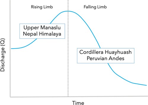
The upper Manaslu region of the Nepal Himalaya and the Cordillera Huayhuash region of the Peruvian Andes are globally significant ‘Water Towers’ as well as conspicuous bellwethers of climate-related hydrological changes in mountain systems (Immerzeel et al., Citation2020; Viviroli et al., Citation2007, Citation2020). They are also home to many highland communities that rely directly on rapidly changing high mountain hydrological systems (FAO, Citation2015; Scott et al., Citation2019; Vuille et al., Citation2018). Annual discharge in glacier-fed rivers in Nepal is generally increasing while annual discharge in glacier-fed rivers in Peru is generally declining (Hock et al., Citation2019). Thus, our multi-sited, community-based assessment provides insights into who is vulnerable (or adaptable), to what stresses, why, and with what implications along both the ‘rising’ and ‘falling’ limbs of the peak water profile .
Figure 1. Location of study sites on hypothetical peak water profile.
3.1 Upper Manaslu, Nepal Himalaya
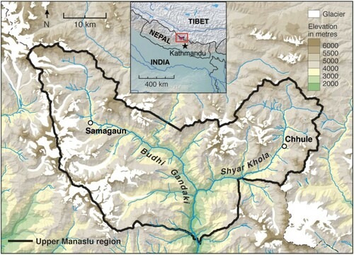
The upper Manaslu region (∼28° 26´ N, 84° 54´ E) is located in the central Nepal Himalayas approximately 100 km from the capital city of Kathmandu. It occupies ∼1663 km² of mountainous terrain in the upper Ghorka District, is the location of Mt Manaslu (8,156 m), and is home to ∼9,000 highland residents who rely heavily on agropastoral livelihoods (NTNC, Citation2019). Its complex terrain and extreme elevation range has led to high levels of biodiversity, including over 2,000 species of plants, 39 mammals, and 201 birds (ibid.). In view of this diversity and with the aim of improving well-being in rural communities, the region was declared a conservation area —Manaslu Conservation Area (MCA)—in 1998. However, the region remains relatively poor and underserviced (Anup & Thapa Parajuli, Citation2015). Compounding long-standing socio-economic challenges, the Ghorka District was the epicenter of the devastating April 2015 Nepal earthquake, an event that caused widespread destruction and trauma and continues to influence regional socio-economic realities in upper Manaslu (Bennike, Citation2017). Moreover, socio-ecological characteristics are being reshaped by road building efforts that aim to connect lowland Nepal and India to China (Bennike, Citation2018), a process wrapped up in Nepalese state-building exercises more broadly (Beazley & Lassoie, Citation2017; Campbell, Citation2010).
The region has summer accumulation type glaciers (maximum accumulation and ablation are synchronous) and hydrological dynamics that are strongly influenced by the Asian Monsoon (Rangwala et al., Citation2015). Total discharge and proportional contributions of glacier melt to river flow are greatest during the summer months when warm temperature and maximum precipitation coincide (Scott et al., Citation2019). Recent work by Robson et al. (Citation2018) suggest that glacier coverage in upper Manaslu declined by 6.7% between 1999 and 2013, consistent with other assessment of glacial recession in the central Himalayas, which indicate that glacier area in the region has been declining at a rate of ∼0.4% per year for the 1970–2010 period (see Bolch et al., Citation2019). Because the region has large glaciers, melt water generation is expected to increase with climate forcing for several decades (Hock et al., Citation2019). Indeed, Huss and Hock (Citation2018) —who calculated runoff for all glaciers in the Randolph Glacier Inventory until year 2100 —found that annual glacier runoff is projected to increase until at least mid-century, followed by steady declines thereafter. This finding is reinforced by glacio-hydrological modelling studies focused specifically on the Himalayan region. For example, Immerzeel et al. (Citation2013), Lutz et al. (Citation2014), and Ragettli et al. (Citation2016) all found melt water generation trends consistent with the rising limb of the peak water profile.
The study communities are located in the Nubri and Tsum valleys. The ethnic Tibetan residents of these valleys on the border of China’s Tibet Autonomous Region have limited access to basic services such as health care facilities and formal education (Childs, Citation2004). Here, agriculture, pastoralism, the collection of non-timber forest products (e.g. ‘yartsa gunbu’ a caterpillar fungus that is prized in Chinese medicine), and trekking support are livelihood activities that enable residents to persist despite limited government support and the demands of life in high mountain environments (Childs & Choedup, Citation2014). Samagaun (pop. ∼1,100) is located at an elevation of 3,500 m in the more frequently visited Nubri Valley, directly downstream from large, rapidly retreating glaciers flanking the east face of Mt Manaslu. Chhule (pop. ∼500) is located in the seldom visited Tsum Valley, where strong Buddhist traditions dictate life under the smaller glaciers of the Buddha, Ganesh, and Sringi Himal (Plachta, Citation2018). Samagaun is a community transitioning under the influence of an emerging trekking economy (Anup & Thapa Parajuli, Citation2015) while Chhule represents a community where customary ways have been less affected by Nepal’s expanding tourism economy. Samagaun and Chhule were selected because of their distinctive upstream glacial environments and differing social conditions; together they represent key aspects of the socio-hydrological diversity of the upper Manaslu region .
Figure 2. Upper Manaslu, Nepal – Region and Target Communities.
3.2 Cordillera Huayhuash, Peruvian Andes
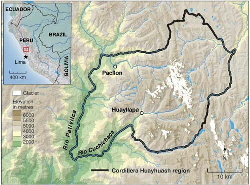
The Cordillera Huayhuash region (∼10° 16° S, 76° 57´ W) is located in the central Peruvian Andes approximately 190 km from the capital city of Lima. It covers 1,167 km²; spans the Ancash, Lima, and Huanuco administrative districts; and is home to around 13,000 mountain residents (INAIGEM, Citation2018). It is also the location of Peru’s second tallest mountain, Yerupajá (6,634 m), as well as 5 other peaks over 6,000 m. The regions extreme vertical relief gives rise to at least six distinct ecological zones and subsequently high biodiversity, including more than 1000 plant species, 60 bird species, and 12 mammal species (Bury, Citation2006, Citation2008). Most human habitation is concentrated along the lower flanks of the range (ibid.). In 2002, a national conservation zone was established (‘Reserved Zone of the Cordillera Huayhuash’); local communities responded by devising their own management scheme to oversee tourism and resource development, consistent with a history of strained relations with the Peruvian government (see Bury & Norris, Citation2013 for elaboration).
The region experiences a pronounced dry season occurs between April and September with a rainy period taking place between October and March; year-round ablation type glaciers augment stream flow in dry periods and increase overall base flow (Rabatel et al., Citation2013). Glacial recession in the Cordillera Huayhuash has been significant, with ∼39% of glacier cover lost since 1962 (∼85 km km² in 1962 to ∼53 km² 2018) (INAIGEM, Citation2018). Because of their relatively small size (Rabatel et al., Citation2013), melt water generation from glaciers in the region is expected to peak quickly (Hock et al., Citation2019). Indeed, Huss and Hock (Citation2018) found that peak water in the low latitude Andes was reached for 82-95% of the glaciated area before 2019. This finding is reinforced by glacio-hydrological modelling studies focused specifically on the tropical Andes. For example, Baraer et al. (Citation2012), working just north of the Cordillera Huayhuash in the Cordillera Blanca, found that glacier recession has been sufficient for glacier-fed rivers to exhibit decreasing dry-season discharge since the 1980s. Likewise, Polk et al. (Citation2017) and Frans et al. (Citation2015) find meltwater production trends from Andean glaciers that are consistent with the falling limb of the peak water profile. Although the overall pattern is of declining meltwater generation (Hock et al., Citation2019), variation in the results of regional studies highlight the sensitivity of projections to methodologies, assumptions, and climate scenarios (Vuille et al., Citation2018).
The study communities are Pacllon and Huayllapa, ‘campesino’ communities that are inhabited primarily by Indigenous Quechua residents. In both communities there is high reliance on agriculture and pastoralism, as minimal government services and often acrimonious relations with the central government and mining companies have limited other economic development opportunities (Bury & Norris, Citation2013). Pacllon (pop. ∼1,700) is located downstream of the heavily glaciated Mt Jirishanca (6,094 m), along the Rio Achin at an elevation of approximately 3,300 m. Livelihoods in Pacllon are focused on agriculture and pastoralism; trekking traffic is limited. Huayllapa (pop. ∼800) is located in an adjacent valley to the south along the Rio Huayllapa at an elevation of approximately 3,600 m. Agriculture and pastoral activities are the backbone of local livelihoods, but a mixed cash-subsistence based economy has begun emerging following an influx of intrepid trekkers set on travelling beyond well-established hiking routes in the Cordillera Blanca. Pacllon and Huayllapa were selected because of their distinctive upstream glacial environments and differing social conditions; together they represent key aspects of the socio-hydrological diversity of the Cordillera Huayhuash .
Figure 3. Cordillera Huayhuash, Peru – Region and Target Communities.
4. Methods
This study utilized household interviews, key informant interviews, and focus groups. The same research protocols were employed in both study regions, enabling direct comparison of results from two distinct mountain ranges (following guidance from Egan & Price, Citation2017; Mills et al., Citation2010 and; Yin, Citation2014). Field research methods were implemented by co-authors D. Lama and G. Jimenez, who are familiar with local languages/dialects, cultural norms, and socio-ecological conditions. They were accompanied by other local research assistants, who helped with logistics such as organizing focus groups as well as practical matters like note taking. Interviews were conducted in local languages/dialects. Field research teams also conducted community walks and observed activities and sites relevant to the study (e.g. water collection activities, water infrastructure). Fieldwork in upper Manaslu, Nepal was carried out in October – November 2018 (3 weeks total), and in the Cordillera Huayhuash, Peru in February – March 2019 (3 weeks total).
Household interviews documented community members’ biographical data; perceptions of hydrological changes; and the nature of exposure-sensitivities, adaptations, and vulnerabilities. A questionnaire comprised of both closed and open choice questions was used to collect information in a manner that promoted flexibility between known topics of interest and topics that emerged during discussion (see Supplementary Materials). The questionnaire was informed by critical work on cross-cultural survey design (Harkness et al., Citation2003), developed in consultation with regional and thematic experts, and piloted with mountain residents in Nepal and Peru prior to data collection. Participants were asked to recall hydrological conditions over the last decade, a temporal scope short enough to enable coherent recollection of past events while long enough to provide insights into the effects of recent, rapid climatic changes in the mountains of Peru and Nepal. Forty household interviews were conducted in each study community (total n = 160) with individuals 18 and older following a stratified random participant selection protocol that prioritized the equal inclusion of men and women and age groups (18-35, 36-55, 56 and older). Interviews focused on individuals within households, although other family members were sometimes present. Summary statistics were calculated for quantitative data from the household interviews. Qualitative content from interviews was examined using manifest (explicitly stated) and latent (implicit) content analysis (Bengtsson, Citation2016; Payne & Payne, Citation2004), where responses were grouped and analyzed according to their relationship to exposure, sensitivity, adaptation, and vulnerability.
Key informant interviews were conducted with government officials, community leaders, resource managers, researchers, and members of the private sector. The majority of key informants were from or working in the study regions, although several interviews were also completed with relevant experts in Kathmandu and Huaraz (large cites near the study sites). Such participants were able to elaborate topics that could not be thoroughly evaluated through household interviews.
Focus groups were conducted to gain a deeper understanding of topics identified through household and key informant interviews, to discuss broader socio-ecological realities that condition lived experiences of peak water, and to cross-check information obtained through previous household and key informant interview efforts. One focus group was conducted in each study community (total n = 4) following the completion of household interviews. Participants were recruited from household interview cohorts, with an aim of including community members with a range of perspectives, livelihoods, and socio-economic backgrounds in focus group conversations.
Insights obtained through these methods were compared with hypothesized characteristics of vulnerability from existing glacio-hydrological change literature to evaluate congruence and discord in model-driven and community-based work on the human dimensions of peak water.
5. Results and discussion
One-hundred and sixty household interviews, thirty-four key informant interviews, and four focus groups (one in each study community) were completed by the local co-authors during fieldwork in upper Manaslu and the Cordillera Huayhuash (). Numbers in text below represent findings from the household surveys. In some cases, reported trends are based on household interviewee with less than 50% agreement. Such findings are reported if (1) key informant and/or focus group insights bolstered support for the observation or (2) response rates for opposing response options were markedly lower.
Table 1. Outcome of field research methods.
5.1 EXPOSURE – observations of hydrological changes
Hydrological changes were widely reported in both study regions (). Reductions in glacier cover and thickness are commonly reported by household interview respondents in both upper Manaslu (reduced cover = 84%, reduced thickness = 90%) and the Cordillera Huayhuash (reduced cover = 96%, reduced thickness = 76%). These changes can be observed from afar, in terms of both recently exposed (un-vegetated) and over-steepened slopes adjacent to glaciers as well as ice margins pulling back from terminal moraines. Likewise, observations of reduced snow cover and thickness are nearly ubiquitous in upper Manaslu (reduced cover = 93%, reduced thickness = 98%) and the Cordillera Huayhuash (reduced cover = 91%, reduced thickness = 76%): “I see more rock on the faces of mountains like Yerupajá, Rajucollota, Siula Grande, and Sarapo” (household interviewee #14, Huayllapa). Such observations are consistent with perceptions of declining snowfall amounts in upper Manaslu (73%) and the Cordillera Huayhuash (76%), where increases in the frequency of periods with unusually low snowfall are also reported (upper Manaslu = 84%, Cordillera Huayhuash = 56%).
Table 2. Patterns of hydrological change reported by respondents.
Perceptions of trends in total rainfall amounts are divergent for the study regions, with household interview respondents in upper Manaslu citing an increase in net rainfall inputs (68%) while those in the Cordillera Huayhuash observe strong declines in rainfall (93%), particularly during the austral spring. However, observations of increases in both heavy rainfall events (upper Manaslu = 94%, Cordillera Huayhuash = 80%) and low rainfall periods (upper Manaslu = 61%, Cordillera Huayhuash = 88%) are common across both regions, implying increases in overall rainfall variability in both study regions. Perceptions of precipitation change from upper Manaslu are generally consistent with findings from observational and modelling studies focused on the central Himalayas (Hock et al., Citation2019; Scott et al., Citation2019). The signal for precipitation trends from scientific studies focused on the Peruvian Andes is less clear (Schoolmeester et al., Citation2018), although some regional observational and modelling work has identified a drying trend (e.g. Neukom et al., Citation2015).
In upper Manaslu, 41% of household interview respondents have observed a trend of increasing discharge in the region’s glacier-fed rivers, mirroring expectations from glacio-hydrological modelling studies (e.g. Immerzeel et al., Citation2013; Lutz et al., Citation2014). They also report increases in both the frequency (65%) and intensity (69%) of flooding events, particularly in the summer months. Increased flooding is consistent with accelerated melt rates (i.e. increased discharge generation) as well as reductions in the buffering effects of glaciers; however, increases in precipitation amounts and variability could also influence discharge variability. Likewise, 43% of respondents observed reductions in dry season base flow in glacier-fed rivers, suggestive of a reduction in the seasonal water redistribution capacity of regional glacier systems (Fountain & Tangborn, Citation1985). However, reduced snow cover could also be contributing to this trend. On whole, both total discharge and discharge variability appear to be increasing in glacier-fed rivers in the upper Manaslu region.
In the Cordillera Huayhuash, 48% of household interview respondents noted a decrease in discharge in glacier-fed rivers along with decreases in the frequency (49%) and intensity (50%) of flooding events. Low flow periods are reported to be increasing in both frequency (55%) and intensity (58%). However, as for upper Manaslu, reported discharge trends can be explained by changes in both glacial and non-glacial hydrological components (e.g. precipitation); it is therefore difficult to decouple the underlying drivers of discharge characteristics based solely on participants’ perceptions. On whole, discharge from glacier-fed rivers in the Cordillera Huayhuash appears to be declining with the occurrence of flooding events and low flow periods exhibiting departures from historical patterns.
A quarter of household interview respondents as well as many key informants and focus group participants in upper Manaslu report reductions in discharge in non-glacial (rain- and snow-fed) streams, particularly in winter months. This temporal pattern is consistent with reported reductions in snow cover in the headwater areas of smaller streams. Thus, although a net increase in rainfall is reported, respondents indicated that it often manifests as heavy rainfall events in summer, a phenomenon that increases summertime flooding but does not produce an increase in winter baseflow. Finally, many respondents indicated that several streams had either disappeared or appeared in new locations following the 2015 earthquake.
Perceptions of trends in discharge in non-glacial streams among household interview respondents in the Cordillera Huayhuash are more definitive, with reductions in total discharge widely reported (74%). From a seasonal perspective, reduced discharge is most evident in the austral spring (74%) and winter (94%), consistent with temporal patterns of reported declines in rain and snowfall. Relatedly, observations of reduced water availability in highland springs and lakes were common among household interview respondents in the Cordillera Huayhuash (50%), as these water bodies are also precipitation dependent.
Study participants’ observations of hydrological exposures reinforce expectations that glacial change is already leading to peak water dynamics in the study regions. However, they also highlight trends in rainfall and snowfall that make it difficult to separate a glacier melt water signal from each study region’s broader hydrological contexts. These observations offer a higher degree of spatial and temporal specificity than is currently available in model-driven assessments of hydrological change for the study regions, making them invaluable for understanding the specific hydrological exposures that influence life in upper Manaslu and the Cordilleras Huayhuash. Importantly, although we focus on climate-related drivers of hydrological change, we acknowledge that other non-climatic factors such as deposition of black carbon, which increases melt rates, or land-use practices that affect infiltration and sedimentation may have also influenced regional hydrological changes (Dagsson-Waldhauserova & Meinander, Citation2019; Khoi & Suetsugi, Citation2014).
5.2 SENSITIVITY – water access, use, and proximity
Hydrological changes are widely observed by study participants, but mountain residents are not necessarily sensitive to all hydrological exposures; water access and use as well as proximity to waterways are key factors that influence sensitivity. For example, in upper Manaslu, only 18% of household interview respondents access water from glacier-fed rivers. Water from glacier-fed rivers is used primarily for household uses and watering livestock and also to power water mills and irrigate crops. Most of those accessing water from glacier-fed rivers consider the source to be of medium importance (57%), particularly in the winter months when rainfall and discharge from non-glacial streams are at their lowest levels. In the Cordillera Huayhuash, 50% of household interview respondents access water from glacier-fed rivers. For those accessing water from glacier-fed rivers, the most common uses are irrigation (88%), watering livestock (38%), and home uses (15%); 83% of these people consider this water to be of high importance, particularly in the dry season.
Non-glacial streams are the primary source of surface water in the study regions, with 98% of household interview respondents in upper Manaslu and 84% of respondents in Cordillera Huayhuash indicating reliance on such streams. In both regions, non-glacial streams are considered highly important sources of water for home uses, irrigation, watering livestock, and tourism/trekking activities. Furthermore, in the Cordillera Huayhuash, 94% of household interview respondents rely on water from rain- and snow-fed springs, particularly for household and agricultural uses. Unlike other mountain regions where exposure to foreign tourists is driving socio-cultural changes that increase overall household water demand (see McDowell et al., Citation2013; Palomo, Citation2017), increasing water demand does not yet appear to be a driver of exposure-sensitivity in upper Manaslu or the Cordillera Huayhuash.
Rainfall and snowfall are also vital sources of water; they contribute directly to crop productivity and the quality of high-altitude pasturelands in both study regions. Here, sensitivity is greatest among those entirely dependent on agro-pastoralism, commonly older community members and those without foreign language training (which increases the ability to work in the trekking sector).
Sensitivity is also related to the proximity of settlements and human activities to hydrological exposures. Thus, while many community members may not be sensitive to changes in the amount of water in glacier-fed streams, certain people and infrastructure may be sensitive to other climate-related hydrological changes that affect the dynamics of glacier-fed rivers, as discussed below.
5.3 ADAPTATION and VULNERABILITY – too much, too little, and unpredictable water availability
Changes in the frequency and magnitude of times of too much water, too little water, and unpredictable water availability are lived realities of hydrological change in high mountains. These patterns are consistent with hydrological dynamics associated with peak water —the rising limb (too much water), the falling limb (too little water), and attendant effects on discharge variability (unpredictable availability).
5.3.1 Too much water
The peak water literature has not engaged substantively with the effects of rising limb dynamics on vulnerability, reflecting a strong focus on the consequences of decreasing water availability. However, our findings from field research in upper Manaslu reveal notable vulnerabilities related to increasing discharge. For example, household interview respondents in upper Manaslu report increases in the frequency and intensity of flooding events in summer. Such flooding events have destroyed local homes, watermills, bridges, and trails; tragically, they have also led to the drowning of several children. While some effects of flooding impact the whole community (e.g. trail damage), other effects are differentiated across space as a function of proximity to rivers and streams: “People living near the river are psychologically disturbed because floods have taken the lives of kids and animals” (household interviewee #11 Samagaun). These flood hazards compound concurrent threats posed by glacial lake outburst floods (GLOFs) (Bolch et al., Citation2019), which are a related but lower frequency type of extreme event.
Community members have responded to intensifying hydrological extremes by building makeshift stone barriers along waterways adjacent to key infrastructure and repairing damaged facilities on an ad-hoc basis. Interestingly, many community members view climate-related stresses as being symptomatic of spiritual improprieties and ‘imbalance’ in socio-spiritual relations and therefore view material adaptation efforts as secondary to remediating larger spiritual improprieties (Mcdowell et al., Citation2020). Nevertheless, the reactive, short-term nature of these responses reflects communities’ geographical and political isolation from centralized state services. Insufficient material, financial, and technical capacity as well as limited knowledge about trajectories of climate-related hydrological changes are widely cited as barriers to adaptation. Thus, although we documented community-level effort to respond to flooding hazards, barriers of socio-political origin have severely constrained the scope and effectiveness of local adaptations. This is leading to widespread emotional duress among community members, compounding already significant trauma from the 2015 earthquake.
Enhanced discharge has also increased the entrainment capacity of rivers. Combined with the increased erosive action and sediment production of receding glaciers (Koppes et al., Citation2015), this is leading to heavier sediment loads and reduced water quality: “It is leading to impurities in our drinking water” (household interviewee #12, Chhule). Because of heavy reliance on local rivers and streams for drinking water, minimal water filtration infrastructure, and limited capacity to remediate water quality issues, many community members are vulnerable to reduced drinking water quality. Here again, the ability to moderate exposure-sensitivities is closely linked to geographical and socio-political realities that have reduced the involvement of the Nepalese government in providing basic infrastructure and social services to mountain communities. Although concern about changes in water quality were not widely reported in in the Cordillera Huayhuash, some evidence of increased sediment loads was recorded: “I have noticed that the [glacier-fed] Rio Achin has changed colour. It used to be turquoise but now it is dark grey” (household interviewee #32, Pacllon). Observations of study participants from Nepal and Peru about sediment fluxes are consistent with glacio-hydrological research (Koppes et al., Citation2015; Milner et al., Citation2017), and suggest that enhanced erosion and sediment transport are beginning to impact drinking water quality in high mountain areas without adequate water treatment facilities. However, increased sedimentation could also be related to non-climatic drivers, as mentioned below.
Intensified melt and a reduction in the buffering capacity of glaciers suggests that peak water dynamics influence reported increases in flooding and declines in water quality. Thus, in upper Manaslu, limited reliance on glacier-fed streams for water access does not preclude vulnerability to peak water dynamics; the combination of socially relevant exposures (hydrological hazards and water quality issues) and constraints on adaptation is leading to substantial vulnerability in a region squarely associated with the rising limb of the peak water model. However, because flooding and water quality issues are also reported in non-glacial streams, we believe that increases in summertime rainfall and enhanced snowmelt rates are contemporaneously driving reported exposures. Adding further complexity, household interview respondents indicate that sedimentation increased following the 2015 earthquake, pointing to important interactive effects between slow variables (increasing discharge) and fast variables (the earthquake) (Walker et al., Citation2012) and cumulative effects more broadly (Graf et al., Citation2019; Pant et al., Citation2018). These observations help to situate the effects of rising limb dynamics within context-specific hydrological, social, and environmental realities, and reveal unanticipated vulnerabilities related to times of increasing water availability.
5.3.2 Too little water
The glacio-hydrological modelling literature is focused primarily on the implications of times of too little water availability, an emphasis that draws concern to arid regions such as the western slope of the Peruvian Andes that are already on the falling limb of the peak water profile. Consistent with this framing, 86% of household interview respondents in the Cordillera Huayhuash indicate that times of water scarcity are increasing; scarcity was not cited as an issue in upper Manaslu. Interestingly, however, most respondents in the Cordillera Huayhuash report that declining water availability is most evident in non-glacial streams and rain- and snow-fed springs as well as overall rainwater availability. Only 10% of household interview respondents cited reductions in glacier-fed rivers as a concern, suggesting that discharge reductions are not yet sufficient to jeopardize the viability of glacier-fed rivers as a source of freshwater.
Ninety-seven percent of household interview respondents in the Cordillera Huayhuash indicate being adversely affected by times of too little water. In particular, reduced stream flow and precipitation are threatening agricultural activities and reducing the productivity of grasses in high altitude pasture lands. Community efforts to address agriculture-related challenges involve building water reservoirs and canals to increase water supply, establishing community water boards to organize the equitable use of available water, and adopting improved irrigation technologies to reduce water use. These efforts address both perennial agropastoral difficulties linked to natural climate variability as well as emerging challenges related to contemporary climate-related hydrological changes.
Local adaptations have improved water access and use but have not been sufficient to offset emerging water availability challenges. For example, although community water boards have increased equitable access to available water, the lack of funding and technical expertize for the construction of more extensive water reservoirs and canals means that scarcity is still common in some areas within study communities. Indeed, several sectors (i.e. regions within communities) in Pacllon and Huayllapa do not have irrigation connections, leaving residents of those areas highly sensitive to changing rainfall patterns: “Because there isn’t enough water … we haven't planted corn, wheat, or lima bean in the Agash or Tsimsu sectors in three years” (household interviewee #9 Huayllapa). These residents are often younger families who have had to move onto less desirable plots as a result of population pressure in more central locations. Furthermore, while NGO-led initiatives aimed at increasing access to improved irrigation technologies have reduced overall agricultural water use, some household interview respondents, particularly older residents with limited formal education, report uncertainty about how to properly use improved irrigation technologies. Such uncertainty has led to failed harvests and a subsequent need purchase staple crops from coastal regions to meet nutritional needs. Likewise, when highland pastures are unproductive as a result of declining precipitation, pastoralists buy grasses from the coast and, when purchasing feeds becomes financially prohibitive, sell livestock.
Despite such burdens, many residents report knowledge of and concern about the ecological effects of further increasing water abstraction, citing numerous examples of how reductions in water availability are already impacting regional flora and fauna. For example, one respondent noted that when the community “channels all of the water from the Tacra Raqra [Tacra River], we leave all of the trees and wild plants that grow on its banks to die.” (household interviewee #33 Pacllon). Another community member commenting on over-abstraction lamented: “I no longer hear the song of the toads” (household interviewee #30 Pacllon). Impacts on wild foods as a result of regional drying are also observed: “I have noticed that lakes Tuctu, Turpa, and Argocancha no longer have Cushuro [a nutrient and protein rich algae that is commonly eaten]” (household interviewee #20 Pacllon). Conversely, there is also recognition of how human hardship can present opportunities for non-humans: “if we plant and there isn't enough water we abandon the crops and the wild birds take advantage of what is left” (household interviewee #13 Huayllapa). Responsibility, kinship, and reciprocity shape conceptions of people and place in the Cordillera Huayhuash (and upper Manaslu), and speak to relevance of socio-ecological systems analysis as well as emerging work on relational values (Klain et al., Citation2017) in identifying and navigating tradeoffs in future adaptation plans.
Because discharge reductions in glacier-fed rivers are not especially relevant for study participants in the Cordillera Huayhuash, exposures related to falling limb dynamics do not appear to be a significant component of current vulnerability. But this situation could change if water from non-glacial sources continues to decline and greater reliance is placed on glacier-fed rivers. Several household and key informant interview respondents cited this possibility, suggesting that piping water in from glacier-fed rivers may become necessary if patterns of hydrological change intensify. However, some respondents fear that clandestine mining might already be polluting glacial rivers (see Guittard et al., Citation2017 for illustrative work on this issue). We cannot corroborate these claims based on our analysis, but recognize that co-stressors such as pollution in glacier-fed rivers could foreclose important backstop adaptation options.
Finally, falling limb dynamics may have some local benefits for communities in the Cordillera Huayhuash. About half of the household interview respondents indicated declines in the frequency and intensity of flooding in glacier-fed rivers, which is reducing exposure to hydrological hazards and decreasing the frequency of damage to infrastructure and agricultural land (although observations of hydrometeorological extremes were still widely reported). This contrasts with the situation in upper Manaslu where rising limb dynamics are driving increasing exposure to flooding. On the whole, declining discharge in glacier-fed rivers in the Cordillera Huayhuash appear to be having negligible or even somewhat positive effects for local communities.
5.3.3 Unpredictable water availability
Observations of the increased unpredictability of water availability were noted by household interview respondents in upper Manaslu (41%) and ubiquitous among respondents in the Cordillera Huayhuash (90%). Glacier recession can be viewed as a component of such variability in upper Manaslu; however, respondents in both study sites are primarily concerned with predictability challenges related to rainfall. In upper Manaslu unpredictable rainfall manifests as both more intense heavy rainfall events and unexpected dry periods. Heavy rainfall magnifies flooding issues and damages crops while dry periods pose fundamental threats to rain-dependent agriculture. Adaptations are few and include the abovementioned construction of flood barriers as well as accessing water from the main river for rudimentary irrigation efforts in dry periods. In the Cordillera Huayhuash, reduced predictability in the onset of rainfall poses major problems for agriculture: “The climate has changed a lot. We no longer know exactly when to plant. It damages the growing season.” (household interviewee #32, Huayllapa). Household-level response in the Cordillera Huayhuash include planting crops and accepting that the harvest might be lost if rainfall does not arrive in time for seeds to germinate (risk acceptance), postponing planting until the rainy season begins (risk moderation), and avoiding planting crops all together (risk avoidance). Specific strategies chosen are often based on “knowledge left to us by our grandparents” (household interviewee #36 Pacllon), highlighting the importance of intergenerational knowledge transmission in contemporary adaptation efforts. Notwithstanding flooding issues in upper Manaslu, peak water dynamics appear to have relatively little effect on lived experiences of unpredictable water availability in both study regions.
5.3.4 Expanded geographies of vulnerability peak water
Three characteristics of vulnerability are common in the emerging discourse about vulnerability to peak water: vulnerability will be driven by reductions in water availability in glacier-fed rivers; will be concentrated in arid regions where glacier-fed rivers help to offset moisture deficits; and will be most pronounced in populous areas downstream of mountain areas where water demand is greatest. This translates to a specific geography of vulnerability (see Huss & Hock, Citation2018). However, our results suggest that declining water availability is not the only salient exposure related to peak water; flooding and impacts on water quality also matter, both of which are related to increasing water availability. Thus, moisture-laden regions on the rising limb of the peak water profile are also subject to exposures capable of engendering vulnerability. Indeed, vulnerability to exposures directly related to peak water may be higher in regions like upper Manaslu (rising limb) than the Cordillera Huayhuash (falling limb). However, some level of vulnerability to peak water is observed in both study regions, suggesting that ascribing higher vulnerability to lowland areas because of their relatively greater water demand can obscure vulnerabilities linked to high sensitivity and constraints on adaptive capacity in frontline communities. Furthermore, our results indicate that from the perspective of ‘lived experiences’ it is the combined effects of all socially relevant hydrological changes that matter most to mountain people (e.g. precipitation change, snow cover change, glacial and non-glacial discharge change), not only changes in discharge in glacier-fed rivers (i.e. peak water per se).
Given that nearly 10% of the global population lives in watersheds affected by rapidly changing glacio-hydrological conditions (Hock et al., Citation2019), there is an urgent need to think carefully about how vulnerability is conceptualized and operationalized in research examining the implications of hydrological (and other) changes in mountain regions. Based on our results and those of allied studies (e.g. Bury et al., Citation2013; Carey et al., Citation2014; Drenkhan et al., Citation2015; Mark et al., Citation2010; Mark et al., Citation2017; McDowell et al., Citation2013), we tender the suggestion that examining the effects of glacio-hydrological change through the lens of contextual vulnerability approaches might help to more appropriately target scarce adaptation resources (see Conway et al., Citation2019 for pertinent discussion).
5.4 Limitations
The results of this study are subject to several limitations. For example, our focus on hydrological changes over the last 10 years was selected to support accurate recall, and to enable to participation of younger community members; we recognize that a longer interval might have enriched our findings. In addition, we did not evaluate intra-community socio-cultural dynamics, limiting our ability to identify differentiated experiences of hydrological change within the study communities. Relatedly, we did not substantively evaluate concurrent processes of socio-economic, political, and environmental changes in (or acting upon) the study regions. We are therefore unable to comment on the relative importance of glacio-hydrological changes vis-a-vis other issues faced by residents in our study communities. Our engagement with socio-ecological dynamics is also cursory, constraining our ability to situate our findings within the broader socio-ecological realities of our study regions (see Huss et al., Citation2017; McDowell & Koppes, Citation2017). Moreover, although gender representation is almost balanced in the household survey, insights from key informant interviews and focus groups are biased towards male perspectives; we have fallen short of principles of inclusion outlined in the Thimphu Declaration for mountain women (FAO, Citation2002). Furthermore, husbands were sometimes present during interviews with women, potentially influencing information provided by female study participants.
6. Conclusions
This study used a contextual vulnerability approach to characterize lived experiences of peak water in communities of the upper Manaslu region of the Nepal Himalaya and the Cordillera Huayhuash region of the Peruvian Andes. It determined that community members perceive climate-related hydrological changes that are consistent with the peak water dynamics, and documented which locally observed hydrological changes are socially relevant. Here it was found that numerous hydrological changes beyond those associated with peak water dynamics (e.g. precipitation change) are important to community members. Ultimately, the study revealed patterns of vulnerability that do not match those hypothesized in the glacio-hydrological modelling literature, a finding that raises questions about the sufficiency and appropriateness of glacio-hydrological modelling studies as a basis for targeting adaptation efforts. Thus, while we emphasize the essential role of modelling work in advancing understanding of trajectories of glacio-hydrological change and supporting long-term planning, we argue that such work must be complemented by highly contextualized research and insights from the social sciences to more fully appreciate lived experiences of hydrological change in glacierized watersheds. This situated assessment of peak water represents a modest attempt to advance this vision.
The results of this study illuminate several areas where future research is needed; namely, increasing situated knowledge of lived experiences of changes in water quality, identifying locally appropriate opportunities for addressing adaptation needs, and revealing important socio-ecological interdependencies affected by both glacio-hydrological change and human responses to changing hydrological conditions. More broadly, there is a need for greater attention to lived experiences of hydrological change in high mountain communities (not just downstream areas), where widespread socio-political marginalization engenders vulnerability to even modest hydrological exposures. Such work should involve close collaboration with mountain residents and endeavour to gain a more nuanced understating of socio-economic, cultural, and political dynamics that animate differentiated vulnerabilities associated with hydrological change. Finally, given non-linear trajectories of glacio-hydrological change and ever-evolving social conditions, there is a need for longitudinal assessments of lived experiences of peak water in high mountain communities.
Disclosure statement
No potential conflict of interest was reported by the author(s).
Additional information
Funding
Notes on contributors
Graham McDowell
Graham McDowell is a Banting Postdoctoral Fellow at the University of Zurich, as well as the Project Leader for the Canadian Mountain Assessment. He specialize in climate change vulnerability and adaptation in high mountain socio-ecological systems, with a focus on lived experiences of changes in glacial hydrology. He has led community-level projects in the Nepal Himalaya, Peruvian Andes, Rocky Mountains, Greenland, and Baffin Island as well as numerous large-scale assessments of the human dimensions of climate change in cold regions.
Michele Koppes
Michele Koppes is an Associate Professor of Geography at the University of British Columbia, where she holds a Canada Research Chair in Landscapes of Climate Change. She works at the intersection of climate science, glaciology, geomorphology, and human adaptation.
Leila Harris
Leila Harris is a Professor at the Institute for Resources Environment, and Sustainability (IRES) and the Institute for Gender, Race, Sexuality and Social Justice (GRSJ) at the University of British Columbia. Her work examines social, cultural, political-economic, institutional and equity dimensions of environmental and resource issues.
Kai M. A. Chan
Kai M.A. Chan is a Professor at the Institute for Resources, Environment, and Sustainability (IRES) at the University of British Columbia. He is an interdisciplinary, problem-oriented sustainability scientist, trained in ecology, policy, and ethics.
Martin F. Price
Martin F. Price is an Emeritus Professor at the University of the Highlands and Islands (UHI), Scotland, where he was Director of the Centre for Mountain Studies (CMS) and Chairholder of the UNESCO Chair in Sustainable Mountain Development.
Dhawa G. Lama
Dhawa G. Lama is a guide and research assistant from the Nepal Himalayas. He owns and operates Asia Khamsang Tours & Trekking.
Gladys Jiménez
Gladys Jiménez is a guide and research assistant from the Peruvian Andes. She owns and operates Lost City Treks.
References
- Anup, K. C., & Thapa Parajuli, R. B. (2015). Climate change and Its impact on Tourism in the Manaslu Conservation Area, nepal. Tourism Planning & Development, 12(2), 225–237. https://doi.org/https://doi.org/10.1080/21568316.2014.933122
- Adger, W. N. (2006). Vulnerability. Global Environmental Change, 16(3), 268–281. https://doi.org/https://doi.org/10.1016/j.gloenvcha.2006.02.006
- Adger, W. N., Agrawala, S., Mirza, M. M. Q., Conde, C., O’Brien, K., Pulhin, J., Pulwarty, R., Smit, B., & Takahashi, K. (2007). Assessment of adaptation practices, options, constraints and capacity. Chapter 17: IPCC AR4 Working Group 2 (pp. 717–743).
- Adger, W. N., Eakin, H., & Winkels, A. (2009). Nested and teleconnected vulnerabilities to environmental change. Frontiers in Ecology and the Environment, 7(3), 150–157. https://doi.org/https://doi.org/10.1890/070148
- Adler, C., Huggel, C., Orlove, B., & Nolin, A. (2019). Climate change in the mountain cryosphere: Impacts and responses. Regional Environmental Change, 19(5), 1225–1228. https://doi.org/https://doi.org/10.1007/s10113-019-01507-6
- Baraer, M., Mark, B. G., McKenzie, J. M., Condom, T., Bury, J., Huh, K.-I., Portocarrero, C., Gómez, J., & Rathay, S. (2012). Glacier recession and water resources in Peru's Cordillera Blanca. Journal of Glaciology, 58(207), 134–150. https://doi.org/https://doi.org/10.3189/2012JoG11J186
- Bassett, T. J., & Fogelman, C. (2013). Déjà vu or something new? The adaptation concept in the climate change literature. Geoforum; Journal of Physical, Human, and Regional Geosciences, 48, 42–53. https://doi.org/https://doi.org/10.1016/j.geoforum.2013.04.010
- Beazley, R. E., & Lassoie, J. P. (2017). Himalayan mobilities: An exploration of the impact of expanding rural road networks on social and ecological systems in the Nepalese Himalaya (p. 166). Springer.
- Bengtsson, M. (2016). How to plan and perform a qualitative study using content analysis. NursingPlus Open, 2, 8–14. https://doi.org/https://doi.org/10.1016/j.npls.2016.01.001
- Bennike, R. B. (2017). Aftershock: Reflections on the politics of reconstruction in Northern Gorkha. HIMALAYA, the Journal of the Association for Nepal and Himalayan Studies, 37, 9. https://digitalcommons.macalester.edu/himalaya/vol37/iss2/9
- Bennike, R. B. (2018). Dangerous development. Republica, 37(2), 6.
- Bliss, A., Hock, R., & Radić, V. (2014). Global response of glacier runoff to twenty-first century climate change. Journal of Geophysical Research: Earth Surface, 119(4), 717–730. https://doi.org/https://doi.org/10.1002/2013JF002931
- Bolch, T., Shea, J. M., Liu, S., Azam, F. M., Gao, Y., Gruber, S., Immerzeel, W. W., Kulkarni, A., Li, H., & Tahir, A. A. (2019). Status and change of the cryosphere in the extended Hindu Kush Himalaya region. The Hindu Kush Himalaya Assessment. Springer, 209–255. https://doi.org/https://doi.org/10.1007/978-3-319-92288-1_7
- Bury, J. (2006). New community led conservation efforts in the Cordillera Huayhuash, Peru. Mountain Research and Development, 26(2), 180–182. https://doi.org/https://doi.org/10.1659/0276-4741(2006)26[180:NCCEIT]2.0.CO;2
- Bury, J. (2008). New geographies of Tourism in Peru: Nature-based Tourism and conservation in the Cordillera huayhuash. Tourism Geographies, 10(3), 312–333. https://doi.org/https://doi.org/10.1080/14616680802236311
- Bury, J., Mark, B. G., Carey, M., Young, K. R., McKenzie, J. M., Baraer, M., French, A., & Polk, M. H. (2013). New geographies of water and climate change in Peru: Coupled natural and social transformations in the Santa River watershed. Annals of the Association of American Geographers, 103(2), 363–374. https://doi.org/https://doi.org/10.1080/00045608.2013.754665
- Bury, J., & Norris, T. (2013). Rocks, rangers, and resistance: Mining and conservation frontiers in the Cordillera Huayhuash, Peru. Subterranean struggles: new dynamics of mining, oil, and gas in Latin America. University of Texas Press, 91–118.
- Campbell, B. (2010). Rhetorical routes for development: A road project in Nepal. Contemporary South Asia, 18(3), 267–279. https://doi.org/https://doi.org/10.1080/09584935.2010.501099
- Carey, M., Baraer, M., Mark, B. G., French, A., Bury, J., Young, K. R., & McKenzie, J. M. (2014). Toward hydro-social modeling: Merging human variables and the social sciences with climate-glacier runoff models (Santa River, Peru). Journal of Hydrology, 518, 60–70. https://doi.org/https://doi.org/10.1016/j.jhydrol.2013.11.006
- Carey, M., Molden, O. C., Rasmussen, M. B., Jackson, M., Nolin, A. W., & Mark, B. G. (2017). Impacts of glacier recession and declining meltwater on mountain societies. Annals of the American Association of Geographers, 107(2), 350–359. https://doi.org/https://doi.org/10.1080/24694452.2016.1243039
- Chesnokova, A., Baraer, M., Laperrière-Robillard, T., & Huh, K. (2020). Linking mountain Glacier Retreat and hydrological changes in southwestern Yukon. Water Resources Research, 56(1), e2019WR025706. https://doi.org/https://doi.org/10.1029/2019WR025706
- Childs, G. (2004). Tibetan diary: From birth to death and beyond in a Himalayan valley of Nepal. University of California Press. p. 228.
- Childs, G., & Choedup, N. (2014). Indigenous management strategies and socioeconomic impacts of Yartsa Gunbu (ophiocordyceps sinensis) harvesting in Nubri and Tsum, Nepal. HIMALAYA, the Journal of the Association for Nepal and Himalayan Studies, 34, 7. http://digitalcommons.macalester.edu/himalaya/vol34/iss1/7
- Conway, D., Nicholls, R. J., Brown, S., Tebboth, M. G. L., Adger, W. N., Ahmad, B., Biemans, H., Crick, F., Lutz, A. F., De Campos, R. S., Said, M., Singh, C., Zaroug, M. A. H., Ludi, E., New, M., & Wester, P. (2019). The need for bottom-up assessments of climate risks and adaptation in climate-sensitive regions. Nature Climate Change, 9(7), 503–511. https://doi.org/https://doi.org/10.1038/s41558-019-0502-0
- Dagsson-Waldhauserova, P., & Meinander, O. (2019). Atmosphere—Cryosphere interaction in the Arctic, at high latitudes and mountains With focus on transport, deposition, and effects of dust, black carbon, and other aerosols. Frontiers in Earth Science, 7, 337. https://doi.org/https://doi.org/10.3389/feart.2019.00337
- Drenkhan, F., Carey, M., Huggel, C., Seidel, J., & Oré, M. T. (2015). The changing water cycle: Climatic and socioeconomic drivers of water-related changes in the Andes of Peru. Wiley Interdisciplinary Reviews: Water, 2(6), 715–733. https://doi.org/https://doi.org/10.1002/wat2.1105
- Duethmann, D., Menz, C., Jiang, T., & Vorogushyn, S. (2016). Projections for headwater catchments of the Tarim river reveal glacier retreat and decreasing surface water availability but uncertainties are large. Environmental Research Letters, 11(5), 054024. https://doi.org/https://doi.org/10.1088/1748-9326/11/5/054024
- Egan, P., & Price, M. (2017). Mountain ecosystem services and climate change: A global overview of potential threats and strategies for adaptation (p. 33). UNESCO.
- Ensor, J. E., Wennström, P., Bhatterai, A., Nightingale, A. J., Eriksen, S., & Sillmann, J. (2019). Asking the right questions in adaptation research and practice: Seeing beyond climate impacts in rural Nepal. Environmental Science & Policy, 94, 227–236. https://doi.org/https://doi.org/10.1016/j.envsci.2019.01.013
- FAO. (2002). Thimphu Declaration of the Celebrating Mountain Women conference Thimphu, Bhutan (p. 3).
- FAO. (2015). Mapping the vulnerability of mountain peoples to food insecurity. In R. Romeo, A. Vita, R. Testolin, & T. Hofer (Eds.) (p. 68).
- Farinotti, D., Usselmann, S., Huss, M., Bauder, A., & Funk, M. (2012). Runoff evolution in the Swiss Alps: Projections for selected high-alpine catchments based on ENSEMBLES scenarios. Hydrological Processes, 26(13), 1909–1924. https://doi.org/https://doi.org/10.1002/hyp.8276
- Ford, J. D., Keskitalo, E., Smith, T., Pearce, T., Berrang-Ford, L., Duerden, F., & Smit, B. (2010). Case study and analogue methodologies in climate change vulnerability research. Wiley Interdisciplinary Reviews: Climate Change, 1(3), 374–392. https://doi.org/https://doi.org/10.1002/wcc.48
- Ford, J. D., & Smit, B. (2004). A framework for assessing the vulnerability of communities in the Canadian Arctic to risks associated with climate change. Arctic, 57(3), 389–400. https://www.jstor.org/stable/40512642
- Fountain, A. G., & Tangborn, W. V. (1985). The effect of glaciers on streamflow variations. Water Resources Research, 21(4), 579–586. https://doi.org/https://doi.org/10.1029/WR021i004p00579
- Frans, C., Istanbulluoglu, E., Lettenmaier, D. P., Naz, B. S., Clarke, G. K., Condom, T., Burns, P., & Nolin, A. W. (2015). Predicting glacio-hydrologic change in the headwaters of the Z ongo R iver, C ordillera R eal, B olivia. Water Resources Research, 51(11), 9029–9052. https://doi.org/https://doi.org/10.1002/2014WR016728
- Füssel, H.-M., & Klein, R. J. (2006). Climate change vulnerability assessments: An evolution of conceptual thinking. Climatic Change, 75(3), 301–329. https://doi.org/https://doi.org/10.1007/s10584-006-0329-3
- Graf, E., Attal, M., & Sinclair, H. (2019). Evacuation of earthquake-triggered landslide sediment in the Nepalese Himalaya, Geophysical Research Abstracts.
- Guittard, A., Baraer, M., McKenzie, J. M., Mark, B. G., Wigmore, O., Fernandez, A., Rapre, A. C., Walsh, E., Bury, J., & Carey, M. (2017). Trace-metal contamination in the glacierized Rio Santa watershed, Peru. Environmental Monitoring and Assessment, 189(12), 649. https://doi.org/https://doi.org/10.1007/s10661-017-6353-0
- Harkness, J. A., van de Vijver, F. J., Mohler, P. P., & Wiley, J. (2003). Cross-cultural survey methods (p. 432). Wiley-Interscience Hoboken.
- Hock, R., Rasul, G., Adler, C., Cáceres, B., Gruber, S., Hirabayashi, Y., Jackson, M., Kääb, A., Kang, S., Kutuzov, S., Milner, A., Molau, U., Morin, S., Orlove, B., Steltzer, H., & Contributing Authors. (2019). High mountain areas chapter - IPCC special report on the oceans and cryosphere in a changing climate (SROCC) (1st ed.). Intergovernmental Panel on Climate Change (IPCC).
- Huggel, C., Muccione, V., Carey, M., James, R., Jurt, C., & Mechler, R. (2019). Loss and damage in the mountain cryosphere. Regional Environmental Change, 19(5), 1387–1399. https://doi.org/https://doi.org/10.1007/s10113-018-1385-8
- Huss, M., Bookhagen, B., Huggel, C., Jacobsen, D., Bradley, R., Clague, J., Vuille, M., Buytaert, W., Cayan, D., & Greenwood, G. (2017). Toward mountains without permanent snow and ice. Earth's Future, 5(5), 418–435. https://doi.org/https://doi.org/10.1002/2016EF000514
- Huss, M., & Hock, R. (2018). Global-scale hydrological response to future glacier mass loss. Nature Climate Change, 8(2), 135–140. https://doi.org/https://doi.org/10.1038/s41558-017-0049-x
- Immerzeel, W. W., Lutz, A., Andrade, M., Bahl, A., Biemans, H., Bolch, T., Hyde, S., Brumby, S., Davies, B., & Elmore, A. (2020). Importance and vulnerability of the world’s water towers. Nature, 577(7790), 364–369. https://doi.org/https://doi.org/10.1038/s41586-019-1822-y
- Immerzeel, W. W., Pellicciotti, F., & Bierkens, M. F. P. (2013). Rising river flows throughout the twenty-first century in two Himalayan glacierized watersheds. Nature Geoscience, 6(9), 742. https://doi.org/https://doi.org/10.1038/ngeo1896
- INAIGEM. (2018). Inventario Nacional de Glaciares: Las Cordilleras Glaciares del Perú (p. 198). Instituto Nacional de Investigación en Glaciares y Ecosistemas de Montaña.
- Jansson, P., Hock, R., & Schneider, T. (2003). The concept of glacier storage: A review. Journal of Hydrology, 282(1-4), 116–129. https://doi.org/https://doi.org/10.1016/S0022-1694(03)00258-0
- Kelly, P. M., & Adger, W. N. (2000). Theory and practice in assessing vulnerability to climate change and facilitating adaptation. Climatic Change, 47(4), 325–352. https://doi.org/https://doi.org/10.1023/A:1005627828199
- Khoi, D. N., & Suetsugi, T. (2014). Impact of climate and land-use changes on hydrological processes and sediment yield—a case study of the be river catchment, Vietnam. Hydrological Sciences Journal, 59(5), 1095–1108. https://doi.org/https://doi.org/10.1080/02626667.2013.819433
- Klain, S. C., Olmsted, P., Chan, K. M., & Satterfield, T. (2017). Relational values resonate broadly and differently than intrinsic or instrumental values, or the New ecological paradigm. PLoS ONE, 12(8), e0183962. https://doi.org/https://doi.org/10.1371/journal.pone.0183962
- Koppes, M., Hallet, B., Rignot, E., Mouginot, J., Wellner, J. S., & Boldt, K. (2015). Observed latitudinal variations in erosion as a function of glacier dynamics. Nature, 526(7571), 100–103. https://doi.org/https://doi.org/10.1038/nature15385
- La Frenierre, J., & Mark, B. G. (2014). A review of methods for estimating the contribution of glacial meltwater to total watershed discharge. Progress in Physical Geography, 38(2), 173–200. https://doi.org/https://doi.org/10.1177/0309133313516161
- Lutz, A., Immerzeel, W., Shrestha, A., & Bierkens, M. (2014). Consistent increase in high Asia's runoff due to increasing glacier melt and precipitation. Nature Climate Change, 4(7), 587. https://doi.org/https://doi.org/10.1038/nclimate2237
- Mark, B. G., Bury, J., McKenzie, J. M., French, A., & Baraer, M. (2010). Climate change and tropical Andean glacier recession: Evaluating hydrologic changes and livelihood vulnerability in the Cordillera Blanca, Peru. Annals of the Association of American Geographers, 100(4), 794–805. https://doi.org/https://doi.org/10.1080/00045608.2010.497369
- Mark, B. G., French, A., Baraer, M., Carey, M., Bury, J., Young, K. R., Polk, M. H., Wigmore, O., Lagos, P., Crumley, R., McKenzie, J. M., & Lautz, L. (2017). Glacier loss and hydro-social risks in the Peruvian Andes. Global and Planetary Change, 159, 61–76. https://doi.org/https://doi.org/10.1016/j.gloplacha.2017.10.003
- McDowell, G., Ford, J. D., Lehner, B., Berrang-Ford, L., & Sherpa, A. (2013). Climate-related hydrological change and human vulnerability in remote mountain regions: A case study from Khumbu, Nepal. Regional Environmental Change, 13(2), 299–310. https://doi.org/https://doi.org/10.1007/s10113-012-0333-2
- Mcdowell, G., Harris, L., Koppes, M., Price, M. F., Chan, K. M., & Lama, D. G. (2020). From needs to actions: Prospects for planned adaptations in high mountain communities. Climatic Change, 163(2), 953–972. https://doi.org/https://doi.org/10.1007/s10584-020-02920-1
- McDowell, G., Huggel, C., Frey, H., Wang, F. M., Cramer, K., & Ricciardi, V. (2019). Adaptation action and research in glaciated mountain systems: Are they enough to meet the challenge of climate change? Global Environmental Change, 54, 19–30. https://doi.org/https://doi.org/10.1016/j.gloenvcha.2018.10.012
- McDowell, G., & Koppes, M. (2017). Robust adaptation research in high mountains: Integrating the scientific, social, and ecological dimensions of glacio-hydrological change. Water, 9(10), 739. https://doi.org/https://doi.org/10.3390/w9100739
- Mills, A. J., Durepos, G., & Wiebe, E. (2010). Encyclopedia of case study research (1st ed. p. 1140). Sage Publications.
- Milner, A. M., Khamis, K., Battin, T. J., Brittain, J. E., Barrand, N. E., Füreder, L., Cauvy-Fraunié, S., Gíslason, G. M., Jacobsen, D., & Hannah, D. M. (2017). Glacier shrinkage driving global changes in downstream systems. Proceedings of the National Academy of Sciences, 114(37), 9770–9778. https://doi.org/https://doi.org/10.1073/pnas.1619807114
- Neukom, R., Rohrer, M., Calanca, P., Salzmann, N., Huggel, C., Acuña, D., Christie, D. A., & Morales, M. S. (2015). Facing unprecedented drying of the Central Andes? Precipitation variability over the period AD 1000–2100. Environmental Research Letters, 10(8), 084017. https://doi.org/https://doi.org/10.1088/1748-9326/10/8/084017
- NTNC. (2019). National Trust for Nature Conservation - Manaslu Conservation Area Project (MCAP). https://ntnc.org.np/project/manaslu-conservation-area-project-mcap
- O'Brien, K., Eriksen, S., Nygaard, L. P., & Schjolden, A. (2007). Why different interpretations of vulnerability matter in climate change discourses. Climate Policy, 7(1), 73–88. https://doi.org/https://doi.org/10.1080/14693062.2007.9685639
- O'Brien, K., & Leichenko, R. M. (2000). Double exposure: Assessing the impacts of climate change within the context of economic globalization. Global Environmental Change, 10(3), 221–232. https://doi.org/https://doi.org/10.1016/S0959-3780(00)00021-2
- Palomo, I. (2017). Climate change impacts on ecosystem services in high mountain areas: A literature review. Mountain Research and Development, 37(2), 179–187. https://doi.org/https://doi.org/10.1659/MRD-JOURNAL-D-16-00110.1
- Pant, R. R., Zhang, F., Rehman, F. U., Wang, G., Ye, M., Zeng, C., & Tang, H. (2018). Spatiotemporal variations of hydrogeochemistry and its controlling factors in the Gandaki River Basin, Central Himalaya Nepal. Science of The Total Environment, 622-623, 770–782. https://doi.org/https://doi.org/10.1016/j.scitotenv.2017.12.063
- Payne, G., & Payne, J. (2004). Key concepts in social research. Sage Research Methods.
- Plachta, N. (2018). Himalayan borderland communities: Identity, belonging, and place among the tsumpas, institute for the science of religion and central Asian studies (p. 260). University of Bern.
- Polk, M. H., Young, K. R., Baraer, M., Mark, B. G., McKenzie, J. M., Bury, J., & Carey, M. (2017). Exploring hydrologic connections between tropical mountain wetlands and glacier recession in Peru's Cordillera blanca. Applied Geography, 78, 94–103. https://doi.org/https://doi.org/10.1016/j.apgeog.2016.11.004
- Rabatel, A., Francou, B., Soruco, A., Gomez, J., Ceballos, J., Basantes, R., Vuille, M., Sicart, J., & Huggel, C. (2013). Current state of glaciers in the tropical Andes: A multi-century perspective on glacier evolution and climate change. The Cryosphere, 7(1), 81–102. https://doi.org/https://doi.org/10.5194/tc-7-81-2013
- Ragettli, S., Immerzeel, W. W., & Pellicciotti, F. (2016). Contrasting climate change impact on river flows from high-altitude catchments in the Himalayan and Andes mountains. Proceedings of the National Academy of Sciences, 113(33), 9222–9227. https://doi.org/https://doi.org/10.1073/pnas.1606526113
- Rangwala, I., Pepin, N., Vuille, M., & Miller, J. (2015). Influence of climate variability and large-scale circulation on the mountain cryosphere. In C. Huggel, M. Carey, J. J. Clague, & A. Kääb (Eds.), The high-mountain cryosphere (pp. 9–27). Cambridge University Press.
- Rasul, G., & Molden, D. (2019). The global social and economic consequences of mountain cryospheric change. Frontiers in Environmental Science, 7. https://doi.org/https://doi.org/10.3389/fenvs.2019.00091
- Ribot, J. (2010). Vulnerability does not fall from the sky: Toward multiscale, pro-poor climate policy. In R. Mearns, & A. Norton (Eds.), Social dimensions of climate change: Equity and vulnerability in a warming world ( (pp. 47–74). The World Bank.
- Robson, B. A., Nuth, C., Nielsen, P. R., Girod, L., Hendrickx, M., & Dahl, S. O. (2018). Spatial variability in patterns of glacier change across the Manaslu range, central Himalaya. Frontiers in Earth Science, 6, 12. https://doi.org/https://doi.org/10.3389/feart.2018.00012
- Schoolmeester, T., Johansen, K. S., Alfthan, B., Baker, E., Hesping, M., & Verbist, K. (2018). The Andean Glacier and Water Atlas – The Impact of Glacier Retreat on Water Resources, UNESCO and GRID-Arendal.
- Scott, C. A., Zhang, F., Mukherji, A., Immerzeel, W., Mustafa, D., & Bharati, L. (2019). Water in the Hindu Kush Himalaya. In P. Wester, A. Mishra, A. Mukherji, & A. B. Shrestha (Eds.), The Hindu Kush Himalaya assessment (pp. 257–299). Springer.
- Smit, B., & Wandel, J. (2006). Adaptation, adaptive capacity and vulnerability. Global Environmental Change, 16(3), 282–292. https://doi.org/https://doi.org/10.1016/j.gloenvcha.2006.03.008
- Stake, R. E. (2013). Multiple case study analysis (p. 342). Guilford Press.
- Turner, B., Kasperson, R., Matson, P., McCarthy, J., Corell, R., Christensen, L., Eckley, N., Kasperson, J., Luers, A., & Martello, M. (2003). A framework for vulnerability analysis in sustainability science. Proceedings of the National Academy of Sciences of the United States of America, 100(14), 8074. https://doi.org/https://doi.org/10.1073/pnas.1231335100
- UNFCCC. (2015). Paris Agreement in: United Nations Framework Convention on Climate Change (Ed.) (p. 16).
- van Tiel, M., Kohn, I., Van Loon, A. F., & Stahl, K. (2019). The compensating effect of glaciers: Characterizing the relation between interannual streamflow variability and glacier cover. Hydrological Processes, 34(3), 553–568. https://doi.org/https://doi.org/10.1002/hyp.13603
- Viviroli, D., Dürr, H. H., Messerli, B., Meybeck, M., & Weingartner, R. (2007). Mountains of the world, water towers for humanity: Typology, mapping, and global significance. Water Resources Research, 43(7), W07447. https://doi.org/https://doi.org/10.1029/2006WR005653
- Viviroli, D., Kummu, M., Meybeck, M., & Wada, Y. (2020). Increasing dependence of lowland population on mountain water resources. Nature Sustainability, 3, 917–928. https://doi.org/https://doi.org/10.1038/s41893-020-0559-9
- Vuille, M., Carey, M., Huggel, C., Buytaert, W., Rabatel, A., Jacobsen, D., Soruco, A., Villacis, M., Yarleque, C., Elison Timm, O., Condom, T., Salzmann, N., & Sicart, J.-E. (2018). Rapid decline of snow and ice in the tropical Andes – Impacts, uncertainties and challenges ahead. Earth-Science Reviews, 176, 195–213. https://doi.org/https://doi.org/10.1016/j.earscirev.2017.09.019
- Walker, B., Carpenter, S., Rockstrom, J., Crépin, A.-S., & Peterson, G. (2012). Drivers,” slow” variables,” fast” variables, shocks, and resilience. Ecology and Society, 17(3), 30–34. https://doi.org/http://dx.doi.org/10.5751/ES-05063-170330
- Yin, R. K. (2014). Case study research: Design and methods (5th ed., p. 312). Sage Publications.