
Abstract
Land-use/land-cover (LU/LC) change is an important component of global environmental change. The need to understand LU/LC change is essential for regional development and land use management towards sustainable development. To understand LU/LC change, the different LU/LC categories and their spatial as well as temporal variability in Tiruchirappalli city has been studied over a period of eight years (1998–2006), using the analysis of Indian Remote Sensing Satellite (IRS) images. In this, an attempt was made to adopt Markov model for obtaining and understanding LU/LC dynamics. Model performance was evaluated between the empirical LU/LC map extracted from CARTOSAT-1 PAN image and the simulated LU/LC map obtained from the Markov model. The future landscape distribution in the year 2014 and 2022 was derived using a Markov model. This result shows that Markov model and geospatial technology together are able to effectively capture the spatio-temporal trend in the landscape pattern associated with urbanization in this region.
1. Introduction
In recent years, global change research has been one of the most active areas of research internationally. Human activities are continually changing the environment on an unprecedented scale and speed. Among the several issues of global environmental change, land-use/land-cover (LU/LC) change can be said to be closely cross-questioned related to natural and human processes. In order to reveal the interaction between the global environment for human survival along with the evolving production systems (agriculture, industrialization/urbanization, etc.), the International Geosphere-Biosphere Programme (IGBP) and the International Human Dimensions Programme on Global Environmental Change (IHDP) jointly proposed LU/LC change research programme in 1995, making it the forefront and hot spot of global change research (Vitousek Citation1994; Turner et al. Citation1995). Anthropogenic changes in LU/LC are being increasingly recognized as critical factors influencing global change.
Viewing the earth from space is now becoming crucial to study and understand the influence of man's activities on the natural resource base over time. In situations of rapid and often unrecorded LU/LC change, observations of the earth from space provide objective information of human utilization of the landscape. Over the past years, data from earth sensing satellites have become vital in mapping the earth's features and infrastructures, managing natural resources and studying environmental change (Opeyemi Citation2006).
In the recent years, with the enhancement of more advanced remote sensing technology and geo-analysis models, monitoring the status and dynamic change of LU/LC thoroughly using high resolution remotely sensed data have become one of the most rapid, credible and effectual methods (Yin et al. Citation2007; Sylla et al. Citation2012).
The models of LU/LC change process fall into two groups: regression-based and spatial transition-based models (Baker Citation1989; Lambin Citation1997; Theobald and Hobbs Citation1998). A majority of researches utilizes regression-based approach, which relates the locations of LU/LC change to a set of spatially explicit variables, and uses models such as logistic (Landis Citation1994; Turner 1987; Wear et al. Citation1998) and hedonic price models (Geohegan et al. 1997). Spatial transition-based models often refer to cellular automaton simulation models, which allow for predicting future land development based on probabilistic estimates with Monte Carlo or other methods ( Clarke et al. Citation1997; Clarke & Gaydos Citation1998). One crucial limit to the development of the process models is, however, the deficiency of explicit modelling tools for change processes in the current generation of remote sensing and GIS systems. Equally important is the issue of data availability (Baker Citation1989). Moreover, few studies have attempted to link satellite remote sensing and GIS to stochastic modelling methods in LU/LC change studies, in spite of the fact that the techniques for such linkages have become mature in recent years due to advances in the technology of GIS and its integration with remote sensing (Weng Citation2002).
For all the models available, Markov model has been widely used to model LU/LC changes including both urban and non-urban areas at large spatial scales. It studies the initial occupation and transition probabilities of different states, accordingly to determine the trend of development and predict the state of the future. It is widely used in the analysis of different LU/LC types and dynamic changes. Its applicability and feasibility had been testified in many research papers and its results approximately conform to observed results (Dongjie et al. Citation2008; Huang et al. Citation2008; Dadhich & Hanaoka Citation2010; Zhang et al. Citation2011).
The aim of the study is to explore the changes that have taken place in the LU/LC over Tiruchirappalli city of Tamil Nadu. A time series of Indian Remote Sensing Satellite (IRS) images, covering eight years were used to obtain and analyse LU/LC change dynamics by the combined use of satellite remote sensing, geographic information systems (GIS) and stochastic modelling technologies. An attempt was also made to obtain simulated LU/LC for the year 2022 using a Markov model. The model is the spatial transition based whereby transition areas and probabilities are generated from two time series LU/LC maps in order to predict changes at a specified time in the future (Logsdon et al. Citation1996).
2. Study area and data
2.1. Study area
The study area is Tiruchirappalli town, Tamil Nadu (figure ), one of the famous historical and cultural cities in India. The spatial extend of the study area is between 10˚44’ 46” to 10˚ 52’ 46” N latitude and 78˚ 39’ 11” to 78˚ 44’ 13” E longitude. The study covers an area of approximately 13,262 ha. The average annual rainfall is 821.4 mm. The mean maximum and minimum temperature range from 41.1°C and 18.6°C, respectively (National Informatics Centre Citation2010). The area has been experiencing remarkable LU/LC changes due to urban expansion and population pressure (figure ). Its landscapes are abundant with economic and social activity facilitated by rapid developments in residential, educational, commercial, industrial, recreational and traffic and transportation sectors (Tiruchirappalli Local Planning Authority Citation2012). So, it is necessary to monitor the LU/LC change for understanding the current scenario and to plan the future development of the city. In this, the latest geospatial technology is required to simulate current and future changes for the study area.
Figure 1. Location of study area.
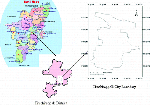
Figure 2. Population growth in Tiruchirappalli city during 1871–2011 [National Informatics Centre].
![Figure 2. Population growth in Tiruchirappalli city during 1871–2011 [National Informatics Centre].](/cms/asset/656da88b-f02e-4c05-a946-81348f78d673/tgnh_a_795502_f0002_oc.jpg)
2.2. Data
To study the dynamic changes in LU/LC in Tiruchirappalli city, IRS images were used (). A base map of the Tiruchirappalli city of 2005 was provided by the Local Planning Authority of Tiruchirappalli for preparing the study area boundary. Remote sensing image processing was performed using ERDAS Imagine 9.1 software. IRS data of years 1998, 2006 and 2009, and Survey of India (SOI) Toposheet 58 J/9 (1:50,000) were used to find the spatial and temporal changes in the study area, during the period of study.
Table 1. List of the satellite data used in the study.
3. Method
3.1. Image classification
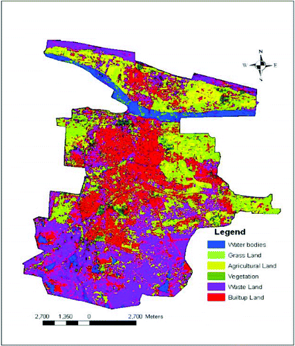
In this study, six LU/LC classes were considered, namely waste land, vegetation, water bodies, grass, built-up land and agricultural land (). The classes in the images were decided based on the LU/LC classification system devised by National Remote Sensing Agency (NRSA) for Indian conditions (Reddy Citation2002). A supervised approach for classification of the image was adopted with the maximum likelihood rule used as a parametric rule (Lillesand & Kiefer Citation2003; Coskun et al. Citation2008). The classified LU/LC maps for years 1998 and 2006 were produced from IRS images and are given in figure and figure , respectively. The area statistics for Tiruchirappalli city is given in .
Table 2. The area statistics from 1998 to 2006.
Figure 3. Classified 1998 IRS image of LU/LC in Tiruchirappalli city.
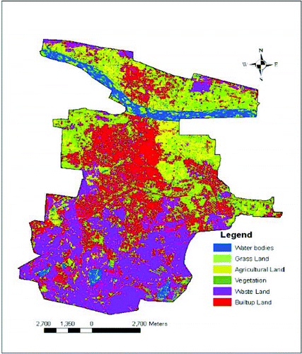
Figure 4. Classified 2006 IRS image of LU/LC in Tiruchirappalli city.
3.2. Markov model in LU/LC change
Markov model is a convenient tool for simulating LU/LC change when changes and processes in the landscape are difficult to describe. A Markov process is one in which the future state of a system can be simulated purely on the basis of the immediately preceding state. Markov model will describe LU/LC change from one period to another and use this as the basis to project future changes. This is achieved by developing a transition probability matrix of LU/LC change from time one to time two, which shows the nature of change while still serving as the basis for projecting to a later time period (Logsdon Citation1996). Markov model provided a simple methodology and by which a dynamic system could be dissected and examined (Muller & Middleton Citation1994; Dongjie et al. Citation2008; Huang et al. Citation2008; Dadhich & Hanaoka Citation2010; Zhang et al. Citation2011). Numerous researches have testified the accuracy of the Markov model (Jianping et al. Citation2005; Zhang et al. Citation2011). The methodology required for Markov model is explained below.
Converting one state into another state of a system is called state transition. If P is transition probability, namely the probability of converting current state to another state in next time, the expression is as follows:
(1) where P stands for probability from state i to state j (Jianping et al. Citation2005; Dongjie et al. Citation2008). Equation (1) must satisfy the next two conditions:
(2)
(3) The key step of the Markov model lies in getting a primary matrix and matrix of transition probability (Pij). Then the Markov forecast model is as follows:
(4) where Pn stands for state probability of any time and P(0) stands for primary matrix.
3.3. Primary matrix for Tiruchirappalli city
The LU/LC types in the study area are divided into six classes. So, on the basis of the information on waste land, vegetation, water bodies, grass, built-up land and agricultural land area that was extracted from IRS image of the year 1998, the calculated area of the above six land use types accounts for 74500.64, 564.66, 796.83, 3153.16, 2531.11 and 1715.67 hectares () and which becomes the primary matrix P(0) = [74500.64, 564.66, 796.83, 3153.16, 2531.11 and 1715.67], for further analysis.
3.4. Matrix of transition probability for Tiruchirappalli
Transition speed from one state to another state is named transition probability, and it may be calculated through annual average transition rate of a certain LU/LC type. Table shows the transition probability of six LU/LC types area in square kilometres (waste land, vegetation, water bodies, grass, built-up land and agricultural land). According to the definition, transition matrix gives the probability that an LU/LC class will change to another class in the future, given the present state of the class. Using equation (1), i.e. , the transition probability of a certain LU/LC type in 1998 converted into the same LU/LC type in 2006 was calculated. Table shows the primary transition probability of six LU/LC types during 1998–2006.
Table 3. LU/LC transitional matrix between 1998 and 2006 (ha).
Table 4. Matrix of primary transition probability of LU/LC types in Tiruchirappalli city during 1998–2006.
4. Results and discussion
4.1. LU/LC change analysis
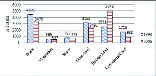
The LU/LC classification results are summarized for the years from 1998 to 2006 in . From 1998 to 2006, built-up area increased by 18.97%. On the other hand, waste land, agricultural land and grass land decreased by 10.68, 8.06 and 6.87%, respectively. All these LU/LC change are closely related with the development of regional economy and the population growth in the city. The trend of LU/LC change in the city is shown in figure .
Figure 5. Comparison of LU/LC change in Tiruchirappalli from 1998 to 2006.
4.2 Accuracy assessment of classification
Each of the LU/LC map was compared with reference data to assess the accuracy of the classification. A GPS field survey was employed as ground truth data to verify the classification accuracy using ERDAS Imagine 9.1 software. The accuracy assessment procedure is a very effective way to represent accuracy in that the accuracies of each category are plainly described along with both the errors of inclusion (commission errors) and errors of exclusion (omission errors) present in the classification (Congalton Citation1991). The overall accuracy of the images of 1998 and 2006 were observed to be 85.47% and 88.27%, respectively and the corresponding kappa coefficients were 0.85 and 0.89. Both producer's and user's accuracy (Congalton Citation1991; Verbyla Citation2005) were over 85%. The minimum level of interpretation accuracy in the identification of LU/LC categories from remote sensing data should be at least 85% (Anderson et al. Citation1976).
4.3. Modelling results and validation
Markov model is a model about the trends forecast, and if current artificial factors continued, the results would gradually change along a certain trend, and tend to stabilize in a long time and reach a balance state at last. Equation (4) was used to find the change in trend of LU/LC types in the successive years. The Excel MMULT function calculates the matrix product of two arrays. The format of the function is: MMULT (array1, array2). Where array1 and array2 are arrays of numerical values, representing matrices, where the number of columns in array1 is equal to the number of rows in array2. Using the function MMULT in EXCEL, through multi-step operation, the transition probability matrix Pij was obtained and was thus used to simulate the changes for the future. Table shows the simulated change trends of LU/LC types in Tiruchirappalli city for the next 16 years.
Table 5. Change trend of LU/LC types simulated by Markov model.
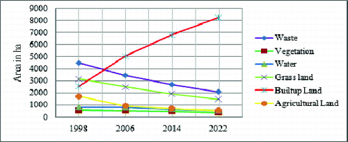
The simulated results based on a Markov model indicate that the area percentage of built-up land in Tiruchirappalli city had sharply increased from 19.08% in 1998 to 38.06% in 2006 and after 16 years, i.e. in the year 2022, the percentage would have increased to 62.28%. The main reasons of built-up land increase could be because of the gradual population increase, infrastructural, industrial and transportation network development in Tiruchirappalli city. The LU/LC change from 1998 to 2022 in the city is shown in figure .
Figure 6. Simulated LU/LC change from 1998 to 2022 in ha.
The LU/LC modelling is incomplete without validating the model with actual data. So, the results of LU/LC simulated areas need to be compared with actual area. Therefore, the simulated LU/LC areas of 2009 is compared with the actual areas interpreted from 2009 satellite image (CARTOSAT - 1) and result tested with actual values using χ2 test in order to ensure suitability of the model. The test results were as follows:
These findings show that, there is no significant difference between simulated value and actual value. Therefore, Markov model can be used in LU/LC forecast in Tiruchirappalli city. The validation of LU/LC change forecast of Tiruchirappalli city can be seen in .
Table 6. Validation of LU/LC change forecast based on Markov model.
5. Conclusions
This paper aims to show a remote sensing approach in analysing and simulating LU/LC changes of Tiruchirappalli city using multi-dated RS images of years 1998 and 2006. The approach involved remote sensing, geographical information systems and Markov model techniques. The result showed that the areas of the urban settlements in Tiruchirappalli city increased by 19.08% to 38.06% from 1998 to 2006. During this period, waste land (−10.68%) area decreased. The LU/LC trends were simulated for the year 2022 through the use of Markov model. Results indicated that built-up land would have increased by 62.28% in the year 2022. This result shows that the natural equilibrium of the Tiruchirappalli city is threatened by the population pressure of the last 30 years. This work shows that it is feasible to simulate LU/LC change based on remote sensing images and Markov model.
The Markov model, coupled with the geospatial technology has indicated the descriptive capability of trend projection. This spatio-temporal model provides not only a quantitative description of change in the past but also the direction and magnitude of change in the future. However, based on the experimental results and exploratory analysis, limitations are present in the current study.
In this study, only two images were used for analyse the LU/LC change and the images were captured in different date. The transition probability in the Markov chain model is assumed to be uniform. Therefore, it is still difficult to accommodate the unpredictable influence of variables, such as the climate, governmental policy or human disturbance. However, it can be concluded that by incorporating more temporal, high accuracy and same dated images into the prediction of LU/LC change, more accurate long-term forecasts can be made in the future.
Acknowledgements
The authors thank National Remote Sensing Centre (NRSC), India for proving the IRS satellite data. We are also thankful to the Tiruchirappalli City Municipal Corporation and Tiruchirappalli Local Planning Authority for providing the necessary data for the work. We thank two anonymous reviewers and the editor for their valuable comments on the draft of this paper.
References
- Anderson JR, Hardy EE, Roach JT, Witmer RE. 1976. A land use and land cover classification system for use with remote sensor data. Washington, DC: Government Printing Office.
- Baker WL. 1989. A review of models of landscape change. Landscape Ecol. 2:111–133.
- Clarke KC, Gaydos LJ. 1998. Loose-coupling a cellular automaton model and GIS: long-term urban growth prediction for San Francisco and Washington/Baltimore. Int J Geograph Inf Sci. 12:699–714.
- Clarke KC, Hoppen S, Gaydos L. 1997. A self-modifying cellular automaton model of historical urbanization in the San Francisco Bay area. Environ Plan B: Plan Des. 24:247–261.
- Congalton RG. 1991. A review of assessing the accuracy of classification of remotely sensed data. Remote Sens Environ. 37:35–46.
- Coskun GH, Alganci U, Usta G. 2008, Analysis of land use change and urbanization in the Kucukcekmece water basin (Istanbul, Turkey) with temporal satellite data using remote sensing and GIS. Sensors. 8:7213– 7223.
- Dadhich PN, Hanaoka S. 2010. Remote sensing, GIS and Markov's method for land use change detection and prediction of Jaipur district. J Geomatics. 4:9–15.
- Dongjie G, Weijun G, Kazuyuki W, Hidetoshi F. 2008. Land use change of Kitakyushu based on landscape ecology and Markov model. J Geogr Sci. 18:455–468.
- Huang W, Liu H, Luan Q, Bai M, Mu X. 2008. Monitoring urban expansion in Beijing, China by multi temporal TM and spot images. IEEE Proc, IGARSS. 4:695–698.
- Jianping LI, Bai Z, Feng G. 2005. RS-and-GIS-supported forecast of grassland degradation in southwest Songnen plain by Markov model. Geo-spatial Inf Sci. 8:104–06.
- Lambin EF. 1997. Modelling and monitoring land cover change processes in tropical regions. Prog Phys Geogr. 21:375–393.
- Landis JD. 1994. The California urban future model: a new-generation of metropolitan simulation-models. Environ Plan B. 21:399–420.
- Lillesand TM, Kiefer RW. 2003. Remote sensing and image interpretation. New York: John Wiley and Sons.
- Logsdon MG, Bell JE, Westerlund VF. 1996, Probability mapping of land use change: a GIS interface for visualizing transition probability. Comput Environ Urban Syst. 20:389–398.
- Muller RM, Middleton J. 1994. A Markov model of land-use change dynamics in the Niagara region, Ontario, Canada. Landscape Ecol. 9:151–157.
- National Informatics Centre (NIC), Department of Information Technology, Government of India, 2010. [cited 2012 June 25]. Available from: http://www.trichy.tn.nic.in/distprof.htm.
- Opeyemi ZA. 2006. Change detection in land use and land cover using remote sensing data and GIS : a case study of Ilorin its environs in Kwara state [MSc dissertation]. Ibadan: University of Ibadan.
- Reddy AM. 2002. Text book of remote sensing and geographical information systems. Saint John: B.S. Publications.
- Sylla, L., Xiong, D., Zhang, H.Y., Bangoura, S.T., 2012, A GIS technology and method to assess environmental problems from land use/cover changes: Conakry, Coyah and Dubreka region case study. Egypt J Remote Sensing Space Sci. 15:31–38.
- Theobald DM, Hobbs NT. 1998. Forecasting rural land-use change: a comparison of regression and spatial transition-based models. Geogr Environ Model. 2:65–82.
- Tiruchirappalli Local Planning Authority, The Director of Town and Country Planning, Government of Tamil Nadu, 2012. [cited 2012 May 20]. Available from: http://www.trichy.tn.nic.in/tlpa/.
- Turner MG. 1987. Spatial simulation of landscape changes in Georgia: a comparison of three transition models. Landscape Ecol. 1:29–36.
- Turner BL, Skole D, Sanderson S. 1995. Land use and land cover change (LUCC): science/research plan. IGBP Report No. 35, HDP Report No.7, Stovkholm, Geneva.
- Verbyla DL. 2005. Satellite remote sensing of natural resources. New York: Lewis.
- Vitousek PM. 1994. Beyond global warming: ecology and global change. Ecology. 75(7):1861–1876.
- Wear DN, Turner MG, Naiman RJ. 1998. Land cover along an urban-rural gradient: implications for water quality. Ecol Appl. 8:619–630.
- Weng Q. 2002. Land use change analysis in the Zhujiang delta of China using satellite remote sensing, GIS and stochastic modeling. J Environ Manage. 64:273–284.
- Yin D, Chen X, Yan L, Huang Z. 2007. The research and realization of the land-use change forecasting model in development zones based on RS and GIS. IEEE Proc, IGARSS. 3429–3432.
- Zhang R, Tang C, Ma S, Yuan H, Gao L, Fan W. 2011. Using Markov chains to analyze changes in wetland trends in arid Yinchuan plain, China. Math Comput Modell. 54:924–930.