
ABSTRACT
Virtual reality and databases are two technological domains employed in many scientific fields. In archeology, several works are being developed along these lines. This paper presents the workflow for the creation of an executable virtual reality: it integrates a virtualization of the archaeological site of Venta Micena (Granada, Spain) and a database of some of the most relevant archaeological remains from that site. The strength and novelty of this project are that it allows any user or researcher to walk through the archaeological site, pick up and put down any of the remains found there, access the database of the archaeological remains from any place and time, and visualize them in stereoscopic mode, which could unveil new information and conclusions. This document moreover discusses the contributions and possible limitations of this type of technology, as well as key concepts and the significance of archaeological excavation.
GRAPHICAL ABSTRACT
KEYWORDS:
1. Introduction
Virtual reality (VR) is the ability to create immersive, imaginative and interactive simulations for the user through visual and auditory output (Larin Citation2021). In recent years, VR has accelerated its development and is being applied in archeology and many other scientific science. In medicine, it is used to visualize in detail certain parts of the body previously scanned (Goo, Park, and Yoo Citation2020; Hu et al. Citation2019) or as a tool for the treatment of neuronal lesions, simulating goals that the patient aims to achieve in real life (Cheung et al. Citation2014; Maggio et al. Citation2019). In psychology it may be used to treat anxiety and depression (Parsons et al. Citation2017; Parsons and Rizzo Citation2008); and in education, as a new resource to improve the teaching and learning process (Radianti et al. Citation2020; Szcześniak et al. Citation2021). In architecture and engineering, VR serves to anticipate the desired result before building execution (Bashabsheh, Alzoubi, and Ali Citation2019; Zaker and Coloma Citation2018), and as support for the conservation and maintenance of existing buildings (León-Robles, Reinoso-Gordo, and González-Quiñones Citation2019; Reinoso-Gordo et al. Citation2018; Rodríguez-Moreno et al. Citation2018).
Specifically in the field of archeology, 3D content and VR are no new achievements, having been described in the book by Barceló in Citation2000. In Citation2010, Forte introduced the concept of cyberarchaeology, exploring how digital technologies can transform traditional archaeology and site study. Virtual reality is also used to disseminate research by generating virtual visits to museums (Arias et al. Citation2022; Barbieri, Bruno, and Muzzupappa Citation2018; Cassidy et al. Citation2019; Conti et al. Citation2020; Liu et al., Citations. f.; Schofield et al. Citation2018), to document excavations or archaeological campaigns (Aiello et al. Citation2019; Balsi et al. Citation2021; Reinoso-Gordo et al. Citation2020), to improve the conservation of an archaeological site (Cantatore, Lasorella, and Fatiguso Citation2020; Fanani et al. Citation2021; Monterroso-checa et al. Citation2020; Threesiana, Suwardhi, and Riyanto Citation2013) and to search for patterns by applying machine learning techniques to digitized archaeological remains (Bassier, Vergauwen, and Van Genechten Citation2017; Fu et al. Citation2022; Mesanza-Moraza, García-Gómez, and Azkarate Citation2020; Monna et al. Citation2020; Sanders Citation2018). In archaeology, much 3D content starts from a structured point cloud, which is a three-dimensional geometric representation based on the most primitive form (points), from which it is possible to represent the shape, size, position and orientation of objects in space (Aldoma et al. Citation2012; Rusu et al. Citation2008). Furthermore, this spatial information could be augmented with additional data obtained through electromagnetic sensors in different bands of the spectrum (visible, IR, reduced spectrum bands, etc.), thus deriving a point cloud that is spatially located, with local attributes (Grilli, Menna, and Remondino Citation2017).
To date, a point cloud of a real object can be generated by means of three different techniques: i) Automatic photogrammetry, ii) Laser scanning, and iii) structured light. Photogrammetry is defined as the technique that studies and provides a precise definition of the shape, dimensions and position in space of any object, taking measurements from photographs, with overlapping images offering multiple angles to generate 3D point camera locations (Bonneval Citation1972; Hartley and Zisserman Citation2000; Lowe Citation2004). Laser scanning is a technique that emits a laser light that is reflected by a solid body, which returns it to the system, generating a point cloud of all objects touched by the light rays emitted. Structured light denotes the process of projecting a pattern in a known wavelength and capturing the deformed pattern with a sensor sensitive to the wavelength; the object´s shape is recreated through the study of pattern deformation. Using the 3D data acquired from these three techniques, it is possible to compose a virtual environment where a person can feel immersed and interact. Furthermore, the virtual environment can be produced anytime and anywhere.
The technology that allows all of the above is known as virtual reality, and to create VR environments it relies on two graphics engines that are widely used and relatively cost-effective: Unity and Unreal Engine. In a comparative study, Morse (Citation2021) highlights that Unity is free for small companies and costs between $400 and $2400 per year for big companies, it works on the most widely used operating systems, and its code works in C# but does not allow natively working with Visual Scripting except with the plugin called Bold. In turn, Unreal Engine is likewise free but for commercial use, it works with a percentage of royalties, it also works on most operating systems, its code works in C++ and it does allow you to work natively through Visual Scripting called Blueprint. For this reason, it was the engine of choice for our research.
This research introduces an application of immersive virtual reality for archeology allowing any researcher around the world to explore, form hypotheses, or make interpretations about the Venta Micena archaeological site (Orce, Granada, Spain) without needing to visit the site in person. In addition, because the application integrates the database of 30 archaeological remains found at the site, it allows researchers to interact with them and make prescribed queries. The present contribution also discusses the potential impact on archaeology of this development, from more theoretical issues such as the concept of archaeological excavation to more applied aspects such as heritage dissemination.
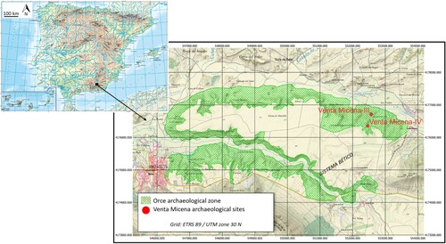
Venta Micena (VM) is an important palaeontological complex from the Early Pleistocene that contains various palaeontological sites explored since the 1980s. They are located on the northeastern limit of the Basin of Guadix-Baza. The exact coordinates of the site are 552459, 417635 ETRS86/UTM ZONE 30 N (). At present the excavation area amounts to some 37 square meters. This sector of the Orce region underwent the dynamics of transgression and regression of a large saline paleolake that dominated this sector of the basin. The wealth and good conservation of fossil accumulations – including species of canids, felids, hyenas, elephants, horses, deer and bovids, of African, Asian and European origin – make VM a key place to study the palaeoecologyy of the Early Pleistocene in southwestern Europe (Ochando et al. Citation2022; Saarinen et al. Citation2021).
Figure 1. Location.
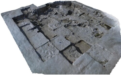
Studies of geochronology and biochronology place it at 1.6-1.5 Ma (Agustí et al. Citation2010; Duval et al. Citation2012). Several sectors have been discovered in VM, the most noteworthy one being VM3, interpreted as a hyena den (Arribas and Palmqvist Citation1998; Palmqvist et al. Citation2022). Another sector, VM4, has been excavated more recently (2005, 2013-2015, 2017-2019) and offers a more complex history; it is interpreted as an open-air site on the margins of bodies of fresh water, an ideal setting for hunting carnivores (Luzón et al. Citation2021; Yravedra Sainz de los Terreros et al. Citation2023).
Excavation at VM4 () poses a great challenge because the abundance of material causes overlapping and interlocking of fossil elements. Additionally, the environmental climate conditions are very different (warmer and drier) from those of the sediment containing the fossils. This can cause small fissures to expand into cracks, compromising the integrity of the fossils. To prevent or mitigate this situation, many fossils (especially bones) are extracted with a bed (base) of sediment that protects the bottom (topographically speaking) of the element. Subsequently, the excavation is completed in the laboratory under more controlled conditions.
Figure 2. Venta Micena archaeological site.
2. Materials and methods
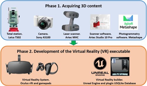
The research is presented in two phases. Phase 1 (P1) involves data acquisition to create 3D meshes of the archaeological remains and of the site itself. Phase 2 (P2) involves integrating the 3D content from P1 (archeological remains and the archeological site) with a database of the recognizable taxonomical and anatomical archaeological remains so that anyone can interact and consult pertinent information through an executable application based on virtual reality.
The equipment and software involved in each phase are presented in . A Leica TS02 total station with an angular accuracy of 3″ and a ranging accuracy of 1.5 mm ± 2 ppm was used, along with a Sony A5100 camera equipped with a 23.5 x Exmor APS-CMOS sensor 15.6 mm^2 and 20 Megapixels. In addition, a portable structured light scanner MHT Artec with 15 frames per second provided a spatial accuracy of 0.5 mm, while Artec Studio 10 Professional and the software Agisoft Metashape (photogrammetry algorithms) were used to generate 3D models (meshes) from the acquired digital photographs. The material used for P2 included Unreal Engine, a video game engine with the external plugin USQLite Database, and the plugins native Oculus Audio, Oculus VR and Oculus Online Subsystem to build the VR environment, while Oculus Rift VR glasses were used with their corresponding gamepad for user immersion.
Figure 3. Equipment and software.
2.1. Acquiring 3D content
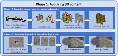
The P1 procedure for acquiring data and generating the meshes of archaeological remains and site can be described in two parallel flows (): P1.i. to acquire the archaeological remain meshes, and P1.ii. to acquire the archaeological site mesh.
Figure 4. Phase 1. Acquiring and generating all the 3D content of the archaeological site.
2.1.2. Archaeological remains
In P1.i., the aim is to generate a 3D textured mesh of each of the most relevant archaeological remains found at the Venta Micena site during the excavation campaigns of 2018 and 2019. To obtain the texturized mesh of each of the archaeological remains, the MHT Artec, a structured light portable scanner served to collect 3d points and Artec Studio 10 Professional was employed to edit, optimize and texture the mesh.
Each archaeological remains is scanned from different points of view to obtain a set of points (point cloud) of the object. Every scan file contains point clouds that further include the information regarding the space surrounding the object, which implies that any “noise” must be removed.
Every scan of a given object is aligned according to tie points to compose a single structured point cloud of the object in a single coordinate system. The algorithm for global optimization of frame positions selects a group of unique geometric points in each frame, then optimizes the position of all the frames, correcting errors and alignment anomalies.
The scans are integrated into a geometric model via a geometric algorithm – fusion – that interpolates multiple views and generates a solid mesh based on triangles. Then, the mesh can be checked for small defects: outliers, filling small holes and surface smoothing. Finally, we can texturize the solid mesh. In this work, we used the “generate textures atlas” method, which cuts the surface into pieces, unfolds and nests them on a flat plane, and fits them into an image of a specified size. The textures were generated with 8192 × 8192 pixels. Some parameters can be edited (brightness, contrast, saturation, gamma correction, hue), and in some cases, the texture healing tool was employed to fill texture gaps in selected areas. The 3D models were exported in OBJ format, providing 30 3D textured meshes pertaining to the most relevant archaeological remains from the excavation campaigns.
2.1.2. Archaeological site
Regarding P1.ii., the objective was to generate a 3D textured mesh of the Venta Micena site at the end of the 2019 excavation campaign. This mesh was obtained using photogrammetry techniques. The techniques entailed a first part of field work, and a second part of lab work.
Regarding field work, seven ground control points were set on the site floor. They were placed along the perimeter and within the archaeological site, when possible at different heights, as recommended by Martínez-Carricondo et al. (Citation2018) and Nagendran, Tung, and Mohamad Ismail (Citation2018). Afterwards, the coordinates of each target were taken with reference to the total station, as previously established through a local reference system.
Once the above was done, and at a time of day that offered optimal lighting conditions, 176 photographs were taken, guaranteeing both longitudinal and transversal overlap greater than 80% as indicated in González-Quiñones et al. (Citation2018).
Regarding the lab work involving Agisoft Metashape software, the first step was aligning the photographs to obtain a sparse cloud. Then, the photo coordinates of all ground control points in each photograph were identified, and the coordinates of each control point obtained with the station are imported. Subsequently, the dense cloud is built along the same local coordinates as the ground control points.
After that, a mesh is constructed from the point cloud, and this mesh is textured. The 3D textured mesh is obtained in local coordinates of the Venta Micena archaeological site.
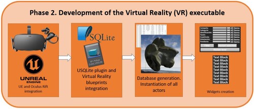
2.2. Development of the VR executable
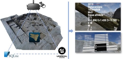
In the P2, the aim is to integrate a database belonging to the scanned archaeological remains with the 3D content obtained in P1, in a single VR scenario, using an executable format. This executable will allow any user, anywhere and at any time, to interact with the Venta Micena archaeological site using the Oculus Rift VR glasses and the database of each of the scanned archaeological remains. Specifically, the user is able to handle the scanned objects, and at that moment the values of each of the variables in the database pertaining to that object appear next to the object in hand, as seen in . In addition, the user can invoke a filtering and search menu based on the values of the database variables using the B button on the gamepad, shown in . The database integrated into the executable contains the following variables: campaign, record number, category, identification, taxon, grid, number, position, orientation and slope. To carry out the above, we followed the workflow shown in (broken down in the following paragraphs).
Figure 5. Screenshot of the appearance of the values of the variables when picking up archaeological remains.
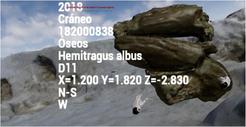
Figure 6. Filter menu screenshot.
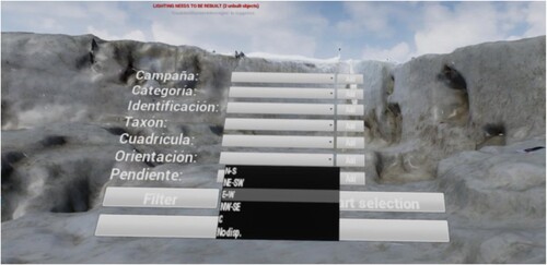
Figure 7. Phase 2. Virtual reality executable generation.
2.2.1. Unreal engine and Oculus Rift integration
Firstly, an Unreal Engine project was configured so that Oculus Rift could interact with the virtual environment to be created. As UE recommends on its website, it is best to proceed by creating a virtual reality type project with Starter Content and perform an initial configuration of the engine settings. Then, the plugins that UE installs by default during installation – Oculus Audio, Oculus VR and Oculus Online Subsystem – must be activated. Additionally, one must choose MSAA as the Anti-Aliasing Method and enable the following parameters: Start in VR, Forward Shading, Instance Stereo, Supports Dash and Composites Depth. Once the above is done, it is possible to start creating content in the project under Oculus Rift – like with any interactive device, receiving and sending data in real time. The device receives image and sound data from the virtual environment where it is running, and sends position and orientation data of the subject's head. In addition, through the gamepads, it can send data on the position and orientation of the subject's hands, activation commands, kind of grasp, and buttons to activate predefined actions.
2.2.2. USQLite plugin and virtual reality blueprints integration
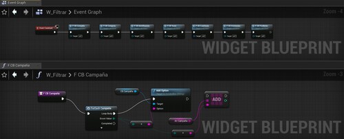
At this point, the USQLite plugin was integrated with the virtual reality blueprints to ensure connectivity between them. It is important to stress that so far (section 2.2.2.) the database is not filled, but rather the blueprints are configured so that the database can be filled in the next section (2.2.3.) when instantiating each actor ().
Figure 8. USQLite plugin and virtual reality blueprints integration.
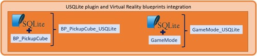
To do this, as mentioned earlier, we worked with the USQLite Database plugin developed by Bruno (Citation2024). First of all, we must bear in mind that the meshes of the archaeological remains containing data from the database will be instantiated objects, actors, able to be pick up and rotate the fossil or remnant of interest via virtual hands and the gamepad. Our starting point was the UE Virtual Reality Start Content asset called BP_PickupCube, which allows this pick-and-drop action. In short, any given actor in that asset can be handled and released. This asset was duplicated and edited as follows: it was labelled BP_PickupCube_USQLite, as many variables were added to the database contents, the interface called SQLiteData belonging to the plugin was likewise added, and the Blueprint structure shown in was added. Next, an asset of SQL Database class named DataBase was created. In this asset, as many columns as there are variables in the database could be added, labelled with the same name as the variables of the BP_PickupCube_USQLite asset.
Figure 9. Visual Scripting on BP_PickupCube_USQLite so that this class could interact with the database.
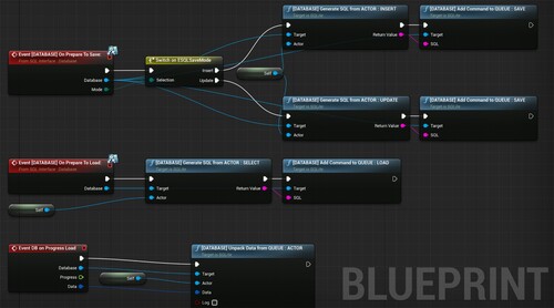
In addition to the two previous assets, a further Game Mode Base class asset called GameMode_USQLite was created, and configured as follows: the SQLiteDriver interface was added, a variable of type SQLite was created, and the Blueprint structure shown in was added.
Figure 10. Visual Scripting on GameMode_USQLite to load the values from the database when starting the level.
Having completed the process described above, it is now possible to instantiate actors of the BP_PickupCube_USQLite class, to add the desired value to the variables created in that class, and to transfer the value of the relevant variables into a row of the Database.
2.2.3. Database generation. Instantiation of all actors
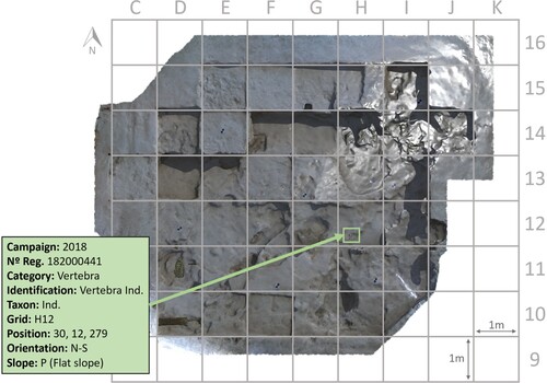
Now it is time to add to the UE level, the meshes corresponding to each archaeological remains developed in P1.i. and the mesh of the archaeological site generated in P1.ii.. Specifically, 30 actors of the BP_PickupCube_USQLite class were instantiated with their corresponding Static Mesh Component containing the mesh of each archaeological remains, and one actor type is instantiated, containing a Static Mesh Component with the mesh of the Venta Micena archaeological site. Furthermore, the corresponding value is added to the created variables (campaign, registration number, category, identification, taxon, grid, number, position, orientation and slope) of each actor (30 actors) instantiated from the BP_PickupCube_USQLite class, as shown in .
Table 1. Database.
The first column of variables in corresponds to the excavation campaign in which the archaeological remains were found; the second corresponds to the registration number within the record of everything found at the site; the third shows the category; the fourth an identification within its categorization; the fifth column defines the taxon of the archaeological remains; the sixth column indicates the grid in which it was found (); the seventh shows the coordinate with respect to the south-west corner, the origin of the grid in meters. The fifth column also expresses the orientation of the longest side of the archaeological remains, while the sixth shows the slope under which it was unearthed.
Figure 11. Archaeological site and remains of Venta Micena 4, including grid and an example of the data in . The origin of each square (0,0) is the southwesternmost corner. Most of the remains are located in squares H14 and I14.
2.2.4. Widget creation
At this point of P2, it is necessary to explain how the data will be displayed and how to interact with them using filtering techniques. To create display menus, there are widget-type classes in UE. For our work, two widgets were developed in parallel, denominated W1 ( and ) and W2 ( and ).
Figure 12. Unreal Engine Widget for the appearance of database variable values when collecting archaeological remains.
Figure 13. Unreal engine widget filter menu.
2.2.4.1. Widget to display the data of the picked-up object
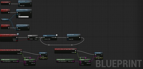
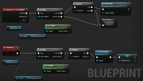
The first, W1, will be invoked when the user picks up any archaeological remnant and is hidden when the user puts it down. It contains nine Text Blocks, each linked to one column of so that when archaeological remains are picked up, the widget will automatically show each value associated with that object in its corresponding Text Block. To develop this logic, a widget called WhilePickup was created, containing the visual script seen in as well as the graphic menu shown in . In addition, two events were added to the BP_PickupCube_USQLite class with their corresponding logic, see , to create the above-described effect. The on-screen ultimate outcome when picking up an object is shown in .
Figure 14. WhilePickup visual scripting.
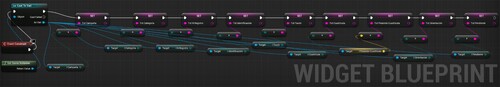
Figure 15. BP_PickupCube_USQLite Visual Scripting to show and hide the widget when picking up the archaeological remains or dropping it, respectively.

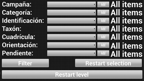
2.2.4.2. Widget to data filter
The second widget, W2, can be invoked or hidden by pressing the B button on the Oculus Rift gamepad. When pressed, a floating menu appears, with the same position and orientation relative to the user's view. In other words, the menu follows all movements that users make with their head. This feature is based on logic developed and shared by Just2devs (Citation2024). A piece of this logic is shown in .
Figure 16. Part of the logic developed by Just2devs to show and hide a floating menu with a constant position and orientation relative to the user's view, invoked or hidden with the A button of the Oculus Rift gamepad.
The logic behind W2 is quite complex and will therefore be broken down for complete description in the next four subsections. The first part, which we will call W2.a., contains seven drop-down menus corresponding to the seven columns of . The name of each drop-down menu matches name heading of each column: campaign, category, identification, taxon, grid, orientation and slope. Each drop-down menu is a combobox-type graphic object that contains all the different values that each previous variables can adopt. The logic that builds each drop-down menu is displayed in .
Figure 17. W2.a. Construction of each dropdown menu.
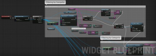
The next part, designated W2.b, contains the filtering logic: the drop-down menus created in W2.a., the seven buttons with the text “Add”, seven lines of text made up of graphic objects of textblock type, and a button with the text “Filter”. This functionality allows the user to select one or more values for every variable from each drop-down menu, then incorporate them using the Add button to the text line corresponding to the added variable. The ensuing logic is presented in . Once the values of the desired variables have been added, the user can press the filter button to leave inside the executable only those objects containing at least one of the selected values. The logic that performs the filtering is presented in .
Figure 18. W2.b. Visual scripting to add text to the textblock.
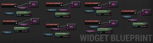
Figure 19. W2.b. Filtering logic.
The next part, W2.c., allows the user to reset the selection of the values added from the drop-down menus by pressing the Restart button. The logic that performs this reset is presented in .
Figure 20. W2.c. to reset the selected and added values of each dropdown menu.

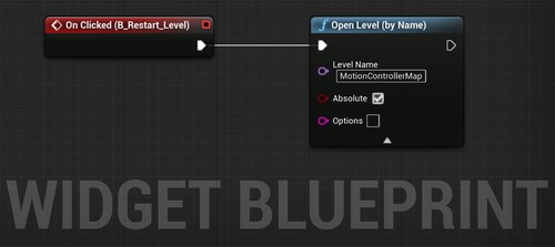
The last part of W2, called W2.d., allows the user to perform whatever filtering they wish to, without needing to undress the Oculus Rift system. One simply restarts the level using the Restart level button. The corresponding logic is seen in . The on-screen ultimate outcome when filtering is shown in .
Figure 21. W2.d., to restart the level.
By following the complete process described above, it is possible to develop an executable that integrates the virtualization of an archaeological site with the database of specific archaeological remains. The contribution of this research to science in general and to archaeology in particular will be discussed in the following section.
3. Results and discussion
The main result of this work is an executable stereoscopic viewer compatible with virtual reality glasses, developed in the context of the Venta Micena archaeological site (Orce, Granada, Spain), that allows any user to interact with the remains of the site and access the database to obtain information about each of the virtualized archaeological pieces, in this case, the 30 most relevant ones encountered at Venta Micena. The variables presented in the USQLite database are: campaign when found, record number, category, identification, taxon, grid, position, orientation and slope. Archaeological excavation faces a paradox: in order to generate scientific knowledge, it is necessary to dramatically disturb the preservation environs of fossils. This disruption affects many aspects of how the extracted elements were deposited and housed from the time they were buried until their recovery by specialists.
This paradox has led to many a reflection about the “nature” of excavation as a largely destructive activity. Sir Mortimer Wheeler, one of the fathers of modern Field Archeology, stated: “At best, excavation is destruction; and the destruction unmitigated by all the resources of contemporary knowledge and accumulated experience cannot be challenged too rigorously” (Wheeler Citation1954). Yet not all archaeologists agree with this viewpoint. Barker (Citation1982) highlighted the character of “unrepeatable experiment”. Venta Micena is located within Andalusia (Spain), an autonomous community whose government has powers in legislating matters of heritage, with the broad understanding that researchers excavate to preserve.
The underlying debate must weigh the importance of the archaeological objects themselves (fetishism), of the discoveries (Shanks and Tilley Citation1989), and the relevance of their meaning. Authors such as (Lucas Citation2001) focus on the hermeneutical nature of archaeological excavation. And over the years, documentation has become the quintessential form of information gathering in archaeology. The traditional means of collecting, ordering, and storing information in analogical archives have been greatly enriched by digital technologies developed in the past three decades, with the widespread use of personal computers and database software (Huvila, Sköld, and Börjesson Citation2021).
The tool presented in this work combines aspects of more traditional archeology with very recent developments. Thus, a virtual environment can be created to transfer the extracted fossils to study realms using the following information and elements:
Georeference of the midpoint of the element in question (longitude, latitude, altitude);
Orientation of the object in its greatest dimension;
Slope (understood as the point towards which the fossil dives);
Dimensions (to scale the elements once they are scanned);
Photogrammetry of the site (with image taking as frequent as possible);
Scanning of fossils.
Another advantage of this realistic and immersive executable stereoscopic tool is that it overcomes the “unrepeatable experiment” (sensu Barker Citation1982) character of archaeological excavations. That is, discovery cannot be repeated, although it can be less “unrepeatable”. Such approaches allow interested members of the scientific community to have visual information closer to the reality of materials forming part of an archaeological site. The tool described here is not intended to replace the reservoir, since certain aspects of the physical sedimentary matrix cannot (yet) be recreated. But the position of the materials is transmitted with great precision, and their texture is reflected as well as currently possible. Altogether, the methodology described here represents an important research advance in terms of spatial distribution, particularly when the elements are highly interlocked or overlapping.
What this type of tool does not impose, in our opinion, is a paradigm shift. Author Kuhn (Citation2012) held that paradigm shifts do not affect the social sciences. Later, Handa (Citation1986) introduced the idea of “social paradigm shift” to refer to the social circumstances that might precipitate changes in our bodies of knowledge. Regarding the case at hand, no such change has emerged from the existence of so-called new technologies per se, but rather from the lowering of costs involved and simplification in the use of these technologies (Del Pozo et al. Citation2020).
What these tools do imply is the incorporation of new formats that abbreviate the physical distance that tends to isolate the focal point of research studies, and, from the point of view of dissemination, facilitate the incorporation of new audiences.
The capability to recreate an archaeological site, providing a maximum of information about it (database of the remains) becomes an invitation to anyone, anywhere, at any time, to travel virtually to the archaeological site to contemplate it and theorize with new ideas about the findings. Until now, a researcher who was not physically at the site could hardly make sound interpretations about it (Heilen and Manney Citation2023); nowadays, executable elements of the type proposed in this research reduce the gap.
Traditionally, working at an archaeological site may imply some wear-and-tear, erosion or compression due to the footsteps of the archaeologists themselves. It is very common for archaeologists to navigate the site with very firm steps and bare feet. Because the executable proposed in this research converts the site into a digital element, it can be revisited as often as needed without the site suffering damage. The same can be said of archaeological remains that are digitized and placed in the executable. It is possible to observe and even handle the objects without any damage whatsoever.
The manipulation of the archaeological remains presented in the stereoscopic viewer allows them to be extracted from the site with virtual hands, and viewed from all angles, just as if the archaeological remains were physically held. Additionally, when one starts the viewer, the objects are located at the same precise point, orientation and slope at which they were first discovered or extracted. Likewise, once the virtual archaeological remains have been isolated for observation, one can restart the viewer so that all the remains are placed in their initial extraction position. When picking up the object with virtual hands, the value of the variables integrated in the SQLite database appear on the viewer screen, giving the campaign in which it was found, registration number, category, identification, taxon, grid, position, orientation and slope. Likewise, the viewer allows filtering for each of the previous variables, interacting with the SQLIite database, thus helping the researcher focus on the aspects they consider most relevant. In short, a researcher can now tele-theorize about what was found at a given site.
The procedure put forth here may also streamline and facilitate the documentation and legal processes that research leaders must carry out before or during a campaign. The developed executable allows access to the archaeological site and the archaeological remains with just a few clicks.
Regarding the dissemination and spread of the executable, some legal questions arise that are not fully resolved and are proposed for future research. For instance it might not be best for society to have access to all data – both on the archaeological site and the remains located there – with a high level of resolution, unless they have previously identified and declared the use to be made of such key information (Luo et al. Citation2018). Therefore, we proposed that future endeavours be aimed to establish a Level of Detail for the dissemination of information on archaeological sites. A low Level of Detail could be posted on a website for any user, whereas the high Level of Detail would be reserved for persons who clearly identifies themselves and declare their interests with respect to the site data. More precisely, it could be said that a low Level of Detail is one compiled with a low resolution of meshes and their texture, lending minimal data on each archaeological remnant. In turn, the high Level of Detail could provide evens
In accordance with the human resources required to carry out this kind of works, it is necessary to count on technicians or a work team with knowledge of topography, having experience working with both hardware and software for the generation of 3D content, and adept at object-oriented programming in the arena of Virtual Reality. Knowledge of topography, 3D contents and virtual reality would be the bare minimum. Taking into account virtual reality research at archaeological sites to date (see Introduction), the most noteworthy contribution of our research proposal is the access achieved to the database of the archaeological remains to be studied found. In sum, this approach integrates a database from the excavation works with the virtualization of the archaeological site.
4. Conclusions
It is possible to virtually visit the Venta Micena archaeological site in Orce (Granada, Spain) and access the 3D model of the archaeological remains extracted from it, as well as the most relevant data. In this way, any researcher, anywhere and at any time, will be able to arrive at new conclusions based on the information extracted from the site. Following the workflow scheme outlined here, a given archaeological site, together with the database of the archaeological remains extracted from it, can be digitized for consultation.
For proper conservation of an archaeological site, its documentation is essential. Moreover, conservation is not just about preserving the integrity of fossils or knapped stone structures. Preserving also implies knowledge, as detailed as possible, of the context. The work described here enriches the documentation behind an archeological site, helping us to better understand its former and current contexts, therefore contributing to its conservation.
A main advantages of this type of tool, compared to the traditional methods (record sheets, photographs, etc.), is that the three-dimensional information of each element can be visualized in relation to the rest of the elements. This does not happen with photographs or drawings of traditional excavation plans and sections, which typically record the arrangement of excavated materials year by year. To obtain a comprehensive image, a new composite image with the previous plans and sections would have to be created. With the tool presented in this paper, a unique platform is created in which materials are integrated as they are excavated, recorded, and scanned. Another advantage is that elements appear in plan photographs without showing their full vertical dimension (topographically speaking). The scanning and virtual return to their original position resolves this limitation. Finally, we can adopt different angles for visualization and preliminary spatial exploration, not just fixed views (top-down and/or lateral).
Future work along these research lines might attempt to create a classified global repository of digitized archaeological sites that could be consulted by the scientific community. Furthermore, as hardware and software development continue to thrive, it will soon be possible to simulate the mass of objects, improve the detail in obtaining meshes and textures of archaeological remains, and recreate more complex environments.
Disclosure statement
No potential conflict of interest was reported by the author(s).
Additional information
Funding
Notes on contributors
Juan José González-Quiñones
Juan José González-Quiñones holds a Bachelor's Degree and a Master´s Degree in Civil Engineering (2014), Master's Degree in Remotely Piloted Aircraft Systems (2015), Master's Degree in Teacher Training for Compulsory and Upper Secondary Education, Vocational Education and Training and Language Teaching (sp. in mathematics) (2018) and a drone pilot-operator licence. Also a Ph. D. candidate at the University of Granada. As for university teaching, he has taught in two different Master's Degrees and in two different Bachelor´s Degrees. Specifically, in the master's degree in drones at the University of Almería (2016-2018), in the Master's Degree in remotely piloted aerial systems at the National Institute of Aerospace Technology (INTA) and the University of Huelva (2018-current), in the Bachelor´s degree in Primary Education and in the bachelor´s degree in Early Childhood Education (2018-currently) of the University of Granada. More than 1200 university teaching hours. Regarding research, he has participated in five national projects in Spain. He has published five JCR papers and took part in three international conferences. His research area is the application of metrics on images and 3D technology in the fields of archaeology, engineering and education.
Alexia Serrano-Ramos
Alexia Serrano-Ramos holds a PhD in History and Arts from the University of Granada and specialized in Virtual Archaeology and Anthropology. Her thesis dealt with human skull variation in prehistoric populations of Canary Islands by the means of 3D models, 3D Geometric Morphometrics and multivariate statistics. She has a long experience in prehistoric excavations (ranging from Iron Age to Lower Palaeolithic) but also in Archaeological Museums, working in inventorying, cataloguing and dissemination activities. She is a member of the research group “Quaternary and Human Evolution in Africa and South Iberia” (CUATE) and currently works as a researcher in University of Granada for the Orce Project (Early Pleistocene sites in Granada, Spain), where she has been an active member since 2017, especially managing the computerized archaeological system, 3D documentation, archaeological reports and multidisciplinary research.
Juan Francisco Reinoso-Gordo
Juan Francisco Reinoso-Gordo holds a Ph.D. in Geodesy and Cartography Engineering by University of Jaén (Spain), from 2000 to the present he has been a lecturer in the Cartography, Geodesy and Photogrammetry Engineering Area at the University of Granada and teaches on the Civil Engineering Degree and Architecture Degree at the University of Granada. From 1996 to 2000 he was a lecturer at the University of Jaén in subjects related to Survey. He has been Principal Investigator of international research projects (University of Davis, California) as well as national and regional projects in Spain. He has also been part of research teams in several projects. His research branches are related to Cartographic Generalization, Digital Terrain Models, Archaeological and Architectural Heritage, Geomatics and Environment. He has published more than 90 scientific contributions including articles and conference papers. He was visiting professor at universities in the United States, Brazil and Portugal.
Juan Manuel Jiménez-Arenas
Juan Manuel Jiménez-Arenas graduated in History from the University of Malaga and obtained his PhD from the University of Granada. He is currently a Professor in the Department of Prehistory and Archaeology at the same university. Since 2017 he is the Head of the “ProjectORCE” funded by the Junta de Andalucía. He has published around 50 articles in internationally renowned journals focusing on human variability, and on the early settlement of the Iberian Peninsula and its palaeoecological context. In 2013 and 2022 he was awarded the Research Excellence Prize of the University of Granada. He is also the Head of two competitive projects focused on the Orce Basin Archaeological Zone. Later he was the Head of the University Institute for Peace and Conflict Research of the University of Granada (2017-2021), collaborating in numerous international projects, especially in Colombia. Finally, it should be noted that, before turning his professional career around, he worked as a clarinetist with the Málaga Wind Orchestra (1988-2002).
References
- Agustí, J., H. A. Blain, M. Furió, R. De Marfá, and A. Santos-Cubedo. 2010. “The Early Pleistocene Small Vertebrate Succession from the Orce Region (Guadix-Baza Basin.” SE Spain) and its bearing on the first human occupation of Europe. Quaternary International 223-224: 162–169. https://doi.org/10.1016/J.QUAINT.2009.12.011.
- Aiello, D., F. Buscemi, G. D’Agostino, M. Galizia, P. Militello, and C. Santagati. 2019. “Low Cost Techniques for the Digital Survey of a Minoan Architecture in the Archeological Site of Phaistos (Crete).” The International Archives of the Photogrammetry, Remote Sensing and Spatial Information Sciences XLII-2-W17 (2/W17): 31–38. https://doi.org/10.5194/ISPRS-ARCHIVES-XLII-2-W17-31-2019.
- Aldoma, A., Z. C. Marton, F. Tombari, W. Wohlkinger, C. Potthast, B. Zeisl, R. Rusu, S. Gedikli, and M. Vincze. 2012. “Tutorial: Point Cloud Library: Three-Dimensional Object Recognition and 6 DOF Pose Estimation.” IEEE Robotics and Automation Magazine 19 (3): 80–91. https://doi.org/10.1109/MRA.2012.2206675.
- Arias, F., C. Enríquez, J. M. Jurado, L. Ortega, A. Romero-Manchado, and J. J. Cubillas. 2022. “Use of 3D Models as a Didactic Resource in Archaeology.” A Case Study Analysis. Heritage Science 10 (1): 1–15. https://doi.org/10.1186/S40494-022-00738-X/FIGURES/12.
- Arribas, A., and P. Palmqvist. 1998. “Taphonomy and Palaeoecology of an Assemblage of Large Mammals: Hyaenid Activity in the Lower Pleistocene Site at Venta Micena (Orce, Guadix-Baza Basin, Granada, Spain).” Geobios 31 (SUPPL. 3): 3–47. https://doi.org/10.1016/S0016-6995(98)80056-9.
- Balsi, M., S. Esposito, P. Fallavollita, M. G. Melis, and M. Milanese. 2021. “Preliminary Archeological Site Survey by UAV-Borne Lidar: A Case Study.” Remote Sensing 13: 332. https://doi.org/10.3390/RS13030332.
- Barbieri, L., F. Bruno, and M. Muzzupappa. 2018. “User-centered Design of a Virtual Reality Exhibit for Archaeological Museums.” International Journal on Interactive Design and Manufacturing 12 (2): 561–571. https://doi.org/10.1007/S12008-017-0414-Z/FIGURES/10.
- Barceló, Juan A, Maurizio Forte, and Donald H Sanders. 2000. Virtual Reality in Archaeology. British Archaeological Reports. Oxford, United kingdom.
- Barker, P. 1982. Techniques of Archaeological Excavation. 2nd ed. London: Routledge.
- Bashabsheh, A. K., H. H. Alzoubi, and M. Z. Ali. 2019. “The Application of Virtual Reality Technology in Architectural Pedagogy for Building Constructions.” Alexandria Engineering Journal 58 (2): 713–723. https://doi.org/10.1016/J.AEJ.2019.06.002.
- Bassier, M., M. Vergauwen, and B. Van Genechten. 2017. “Automated Classification of Heritage Buildings for as-Built Bim Using Machine Learning Techniques.” ISPRS Annals of the Photogrammetry, Remote Sensing and Spatial Information Sciences 4 (2W2): 25–30. https://doi.org/10.5194/ISPRS-ANNALS-IV-2-W2-25-2017.
- Bonneval, H. 1972. Photogrammétrie générale. Paris: Eyrolles.
- Bruno. 2024. USQLite Database Plugin for Unreal Engine. https://www.unrealengine.com/marketplace/en-US/product/usqlite-database
- Cantatore, E., M. Lasorella, and F. Fatiguso. 2020. “Virtual Reality to Support Technical Knowledge in Cultural Heritage. The Case Study of Cryptoporticus in the Archaeological Site of Egnatia (Italy).” The International Archives of the Photogrammetry, Remote Sensing and Spatial Information Sciences XLIV-M-1-2 (M-1): 465–472. https://doi.org/10.5194/ISPRS-ARCHIVES-XLIV-M-1-2020-465-2020.
- Cassidy, B., G. Sim, D. W. Robinson, and D. Gandy. 2019. “A Virtual Reality Platform for Analyzing Remote Archaeological Sites.” Interacting with Computers 31 (2): 167–176. https://doi.org/10.1093/IWC/IWZ011.
- Cheung, K. L., E. Tunik, S. V. Adamovich, L. A. Boyd, K. L. Cheung, L. A. Boyd, E. Tunik, and S. V. Adamovich. 2014. “Neuroplasticity and Virtual Reality.” Virtual Reality Technologies for Health and Clinical Applications, 5–24. https://doi.org/10.1007/978-1-4939-0968-1_2.
- Conti, A., L. Fiorini, R. Massaro, C. Santoni, and G. Tucci. 2020. “HBIM for the Preservation of a Historic Infrastructure: The Carlo III Bridge of the Carolino Aqueduct.” Applied Geomatics 1-11. https://doi.org/10.1007/S12518-020-00335-2.
- Del Pozo, S., P. Rodríguez-Gonzálvez, D. Hernández-López, J. Onrubia-Pintado, D. Guerrero-Sevilla, and D. González-Aguilera. 2020. “Novel Pole Photogrammetric System for Low-Cost Documentation of Archaeological Sites: The Case Study of “Cueva Pintada”.” Remote Sensing 12 (6): 2644. https://doi.org/10.3390/RS12162644.
- Duval, M., C. Falguères, J. J. Bahain, R. Grün, Q. Shao, M. Aubert, J. M. Dolo, et al. 2012. “On the Limits of Using Combined U-Series/ESR Method to Date Fossil Teeth from two Early Pleistocene Archaeological Sites of the Orce Area (Guadix-Baza Basin.” Spain). Quaternary Research 77 (3): 482–491. https://doi.org/10.1016/J.YQRES.2012.01.003.
- Fanani, A. Z., K. Hastuti, A. M. Syarif, and P. W. Harsanto. 2021. “Challenges in Developing Virtual Reality, Augmented Reality and Mixed-Reality Applications: Case Studies on A 3D-Based Tangible Cultural Heritage Conservation.” International Journal of Advanced Computer Science and Applications 12 (11): 219–227. https://doi.org/10.14569/IJACSA.2021.0121126.
- Forte, M. 2010. Cyber-Archaeology. Oxford: Archaeopress.
- Fu, X., Z. Yang, Z. Zeng, Y. Zhang, Q. Zhou, J. D. Wegner, L. A. Courtenay, et al. 2022. “Improvement of Oracle Bone Inscription Recognition Accuracy: A Deep Learning Perspective.” ISPRS International Journal of Geo-Information 11 (1): 45. https://doi.org/10.3390/IJGI11010045.
- González-Quiñones, J., J. Reinoso-Gordo, C. León-Robles, J. García-Balboa, F. Ariza-López, J. J. González-Quiñones, J. F. Reinoso-Gordo, C. A. León-Robles, J. L. García-Balboa, and F. J. Ariza-López. 2018. “Variables Influencing the Accuracy of 3D Modeling of Existing Roads Using Consumer Cameras in Aerial Photogrammetry.” Sensors 18 (11): 3880. https://doi.org/10.3390/s18113880.
- Goo, H. W., S. J. Park, and S. J. Yoo. 2020. “Advanced Medical Use of Three-Dimensional Imaging in Congenital Heart Disease: Augmented Reality, Mixed Reality, Virtual Reality, and Three-Dimensional Printing.” Korean Journal of Radiology 21 (2): 133–145. https://doi.org/10.3348/KJR.2019.0625.
- Grilli, E., F. Menna, and F. Remondino. 2017. “A Review of Point Clouds Segmentation and Classification Algorithms.” The International Archives of the Photogrammetry, Remote Sensing and Spatial Information Sciences XLII. 42, 339–344. https://doi.org/10.5194/isprs-archives-XLII-2-W3-339-2017.
- Handa, M. L. 1986. “Peace Paradigm: Transcending Liberal and Marxian Paradigms.” International Symposium on Science, Technology and Development, New Delhi, India, 20–25.
- Hartley, R., and A. Zisserman. 2000. Multiple View Geometry in Computer Vision. Cambridge: Cambridge university press.
- Heilen, M., and S. A. Manney. 2023. “Refining Archaeological Data Collection and Management.” Advances in Archaeological Practice 11 (1): 1–10. https://doi.org/10.1017/AAP.2022.41.
- Hu, H. Z., X. B. Feng, Z. W. Shao, M. Xie, S. Xu, X. H. Wu, and Z. W. Ye. 2019. “Application and Prospect of Mixed Reality Technology in Medical Field.” Current Medical Science 39 (1): 1–6. https://doi.org/10.1007/S11596-019-1992-8.
- Huvila, I., O. Sköld, and L. Börjesson. 2021. “Documenting Information Making in Archaeological Field Reports.” Journal of Documentation 77 (5): 1107–1127. https://doi.org/10.1108/JD-11-2020-0188/FULL/PDF.
- Just2devs. 2024. Hide and Unhide A VR Widget with A Gamepad Button in Unreal Engine. https://www.youtube.com/@Just2Devs
- Kuhn, T. S. 2012. The Structure of Scientific Revolutions. https://books.google.es/books?hl = es&lr = &id = 3eP5Y_OOuzwC&oi = fnd&pg = PR5&dq = paradigm+shift.+In+a+strict+sense,+Kuhn+proposed+that+paradigm+shifts+did+not+affect+the+social+sciences.&ots = xXXRxbjPtN&sig = FzlNcmvsthgcmKsPLBuoUdhYEJs#v = onepage&q&f = false.
- Larin, M. 2021. “Overview of Current Trends in the Field of Virtual Reality.” Journal A&SE 35.15.
- León-Robles, C. A., J. F. Reinoso-Gordo, and J. J. González-Quiñones. 2019. “Heritage Building Information Modeling (H-BIM) Applied to a Stone Bridge.” ISPRS International Journal of Geo-Information 8 (3): 121. https://doi.org/10.3390/ijgi8030121.
- Liu, Y., Y. Lin, R. Shi, Y. Luo, and H.-N. Liang. s. f. “RelicVR: A Virtual Reality Game for Active Exploration of Archaeological Relics; RelicVR: A Virtual Reality Game for Active Exploration of Archaeological Relics.” Extended Abstracts of the 2021 Annual Symposium on Computer-Human Interaction in Play. https://doi.org/10.1145/3450337
- Lowe, D. G. 2004. “Distinctive Image Features from Scale-Invariant Keypoints.” International Journal of Computer Vision 60 (2): 91–110. https://doi.org/10.1023/B:VISI.0000029664.99615.94.
- Lucas, G. 2001. “Destruction and the Rhetoric of Excavation.” Taylor & FrancisG LucasNorwegian archaeological review 34 (1): 35–46. https://doi.org/10.1080/00293650119347.
- Luo, L., X. Wang, H. Guo, R. Lasaponara, P. Shi, N. Bachagha, L. Li, et al. 2018. “Google Earth as a Powerful Tool for Archaeological and Cultural Heritage Applications: A Review.” Remote Sensing 10 (10): 1558. https://doi.org/10.3390/RS10101558.
- Luzón, C., J. Yravedra, L. A. Courtenay, J. Saarinen, H. A. Blain, D. DeMiguel, S. Viranta, et al. 2021. “Taphonomic and Spatial Analyses from the Early Pleistocene Site of Venta Micena 4 (Orce, Guadix-Baza Basin, Southern Spain).” Scientific Reports 11 (1): 1–17. https://doi.org/10.1038/s41598-021-93261-1.
- Maggio, M. G., R. De Luca, F. Molonia, B. Porcari, M. Destro, C. Casella, R. Salvati, P. Bramanti, and R. S. Calabro. 2019. “Cognitive Rehabilitation in Patients with Traumatic Brain Injury: A Narrative Review on the Emerging use of Virtual Reality.” Journal of Clinical Neuroscience 61: 1–4. https://doi.org/10.1016/J.JOCN.2018.12.020.
- Martínez-Carricondo, P., F. Agüera-Vega, F. Carvajal-Ramírez, F. J. Mesas-Carrascosa, A. García-Ferrer, and F. J. Pérez-Porras. 2018. “Assessment of UAV-Photogrammetric Mapping Accuracy Based on Variation of Ground Control Points.” International Journal of Applied Earth Observation and Geoinformation 72: 1–10. https://doi.org/10.1016/j.jag.2018.05.015.
- Mesanza-Moraza, A., I. García-Gómez, and A. Azkarate. 2020. “Machine Learning for the Built Heritage Archaeological Study.” Journal on Computing and Cultural Heritage (JOCCH) 14 (1): 10. https://doi.org/10.1145/3422993.
- Monna, F., J. Magail, T. Rolland, N. Navarro, J. Wilczek, J. O. Gantulga, Y. Esin, L. Granjon, A. C. Allard, and C. Chateau-Smith. 2020. “Machine Learning for Rapid Mapping of Archaeological Structures Made of dry Stones – Example of Burial Monuments from the Khirgisuur Culture.” Mongolia –. Journal of Cultural Heritage 43: 118–128. https://doi.org/10.1016/J.CULHER.2020.01.002.
- Monterroso-checa, A., A. Redondo-villa, M. Gasparini, A. Hornero, B. Iraci, R. Martín-talaverano, J. C. Moreno-escribano, et al. 2020. “A Heritage Science Workflow to Preserve and Narrate a Rural Archeological Landscape Using Virtual Reality: The Cerro del Castillo of Belmez and Its Surrounding Environment (Cordoba, Spain).” Applied Sciences 10 (23): 8659. https://doi.org/10.3390/APP10238659.
- Morse, C. 2021. “Gaming Engines: Unity, Unreal, and Interactive 3D Spaces.” Technology Architecture + Design 5 (2): 246–249. https://doi.org/10.1080/24751448.2021.1967068.
- Nagendran, S. K., W. Y. Tung, and M. A. Mohamad Ismail. 2018. “Accuracy Assessment on low Altitude UAV-Borne Photogrammetry Outputs Influenced by Ground Control Point at Different Altitude.” IOP Conference Series: Earth and Environmental Science 169 (1): 12031. https://doi.org/10.1088/1755-1315/169/1/012031.
- Ochando, J., J. Carrión, Y. Altolaguirre, M. Munuera, G. Amorós, G. Jiménez-Moreno, J. Solano-García, et al. 2022. “Palynological Investigations in the Orce Archaeological Zone, Early Pleistocene of Southern Spain.” Review of Palaeobotany and Palynology 304: 104725. https://doi.org/10.1016/J.REVPALBO.2022.104725.
- Palmqvist, P., M. P. Espigares, J. A. Pérez-Claros, B. Figueirido, A. Guerra-Merchán, S. Ros-Montoya, G. Rodríguez-Gómez, J. M. García-Aguilar, A. Granados, and B. Martínez-Navarro. 2022. “Déjà vu: a reappraisal of the taphonomy of quarry VM4 of the Early Pleistocene site of Venta Micena (Baza Basin, SE Spain).” Scientific Reports 12 (1): 1–16. https://doi.org/10.1038/s41598-021-04725-3.
- Parsons, T. D., G. Riva, S. Parsons, F. Mantovani, N. Newbutt, L. Lin, E. Venturini, and T. Hall. 2017. “Virtual Reality in Pediatric Psychology.” Pediatrics 140 (Supplement_2): S86–S91. https://doi.org/10.1542/peds.2016-1758I.
- Parsons, T. D., and A. A. Rizzo. 2008. “Affective Outcomes of Virtual Reality Exposure Therapy for Anxiety and Specific Phobias: A Meta-Analysis.” Journal of Behavior Therapy and Experimental Psychiatry 39 (3): 250–261. https://doi.org/10.1016/j.jbtep.2007.07.007.
- Radianti, J., T. A. Majchrzak, J. Fromm, and I. Wohlgenannt. 2020. “A Systematic Review of Immersive Virtual Reality Applications for Higher Education: Design Elements, Lessons Learned, and Research Agenda.” Computers & Education 147: 103778. https://doi.org/10.1016/J.COMPEDU.2019.103778.
- Reinoso-Gordo, J. F., D. Barsky, A. Serrano-Ramos, J. A. Solano-García, C. A. León-Robles, C. Luzón-González, S. Titton, and J. M. Jiménez-Arenas. 2020. “Walking among Mammoths. Remote Sensing and Virtual Reality Supporting the Study and Dissemination of Pleistocene Archaeological Sites: The Case of Fuente Nueva 3 in Orce, Spain.” Sustainability (Switzerland) 12 (11): 4785. https://doi.org/10.3390/su12114785.
- Reinoso-Gordo, J., C. Rodríguez-Moreno, A. Gómez-Blanco, and C. León-Robles. 2018. “Cultural Heritage Conservation and Sustainability Based on Surveying and Modeling: The Case of the 14th Century Building Corral del Carbón (Granada, Spain).” Sustainability 10 (5): 1370. https://doi.org/10.3390/su10051370.
- Rodríguez-Moreno, C., J. F. Reinoso-Gordo, E. Rivas-López, A. Gómez-Blanco, F. J. Ariza-López, and I. Ariza-López. 2018. “From Point Cloud to BIM: An Integrated Workflow for Documentation, Research and Modelling of Architectural Heritage.” Survey Review 50 (360): 212–231. https://doi.org/10.1080/00396265.2016.1259719.
- Rusu, R. B., N. Blodow, Z. C. Marton, and M. Beetz. 2008. “Aligning Point Cloud Views Using Persistent Feature Histograms.” 2008 IEEE/RSJ International Conference on Intelligent Robots and Systems, IROS, 3384-3391. https://doi.org/10.1109/IROS.2008.4650967
- Saarinen, J., O. Oksanen, I. Žliobaitė, M. Fortelius, D. DeMiguel, B. Azanza, H. Bocherens, C. Luzón, J. Solano-García, and J. Yravedra. 2021. “Pliocene to Middle Pleistocene Climate History in the Guadix-Baza Basin, and the Environmental Conditions of Early Homo Dispersal in Europe.” Quaternary Science Reviews 268: 107132. https://doi.org/10.1016/J.QUASCIREV.2021.107132.
- Sanders, D. H. 2018. “Neural Networks, AI, Phone-based VR, Machine Learning, Computer Vision and the CUNAT Automated Translation App-Not Your Father’s Archaeological Toolkit. “Proceedings of the 2018 3rd Digital Heritage International Congress, Digital Heritage 2018 - Held jointly with the 2018 24th International Conference on Virtual Systems and Multimedia, VSMM 2018. https://doi.org/10.1109/DIGITALHERITAGE.2018.8810002
- Schofield, G., G. Beale, N. Beale, M. Fell, D. Hadley, J. Hook, D. Murphy, J. Richards, and L. Thresh. 2018. “Viking VR : Designing a Virtual Reality Experience for a Museum.” DIS 2018 - Proceedings of the 2018 Designing Interactive Systems Conference 805–816. https://doi.org/10.1145/3196709.3196714
- Shanks, M., and C. Tilley. 1989. “Archaeology Into the 1990s.” Norwegian Archaeological Review 22 (1): 1–12. https://doi.org/10.1080/00293652.1989.9965480/ASSET//CMS/ASSET/9E8A247D-E4DF-4A64-9FBE-9F6806461F18/00293652.1989.9965480.FP.PNG.
- Szcześniak, D., A. Gładka, B. Misiak, A. Cyran, and J. Rymaszewska. 2021. “The SARS-CoV-2 and Mental Health: From Biological Mechanisms to Social Consequences.” Progress in Neuro-Psychopharmacology and Biological Psychiatry 104: 110046. https://doi.org/10.1016/j.pnpbp.2020.110046.
- Threesiana, R., D. Suwardhi, and S. Riyanto. 2013. “Development Of Virtual Reality Gis For Cultural Heritage Conservation (Case Study: Sewu Temple).” Indonesian Journal of Geospatial 2 (1): 17–30. https://garuda.kemdikbud.go.id/documents/detail/425410.
- Wheeler, M. 1954. Archaeology from the Earth. Oxford: Oxford clarendon press.
- Yravedra Sainz de los Terreros, J., C. Luzón, J. A. Solano, G. J. Linares-Matas, V. Estaca-Gomez, J. J. Rodríguez-Alba, L. A. Courtenay, D. Herranz-Rodrigo, and A. Serrano-Ramos. 2023. “To den or not to den. Contributions to the Taphonomic History of the Early Pleistocene Site of Venta Micena 4 (Orce, Guadix-Baza Basin).” Quaternary Science Reviews 308: 108031. https://doi.org/10.1016/J.QUASCIREV.2023.108031.
- Zaker, R., and E. Coloma. 2018. “Virtual Reality-Integrated Workflow in BIM-Enabled Projects Collaboration and Design Review: A Case Study.” Visualization in Engineering 6 (1): 1–15. https://doi.org/10.1186/S40327-018-0065-6/FIGURES/15.