
Abstract
Global warming and rapid population growth are two of the most pressing issues in today’s world. There is growing evidence of rising temperatures. The urban heat island effect is a significant environmental issue facing cities today. Although this issue has gained much attention from developed countries, countries in Africa are yet to grapple with it on a significant scale. This paper examined the rising research dimensions and major methodological techniques in studying urban heat effects. The paper adopted a systematic review method where peer-reviewed articles formed the trajectory of debate on Urban Heat Island (UHI) in African cities. The paper finds remote sensing the most common method in analysing UHI effect than ground use technology (weather station), which is limited in spatial spread in most African countries. Urbanization and other human-induced factors majorly contribute to UHI and this has an impact on many elements of life, including morbidity, mortality, birth weight decrease, and social strife. The paper recommends research priority on UHI effect in African cities due to the rising population.
PUBLIC INTEREST STATEMENT
Urban Heat Island effect is impacting the health and well-being of city dwellers as a result of rapid urbanization and other human factors. While the debate on urban heat island has received much attention in developed worlds, that in developing countries like Africa is still limited. Remote sensing satellite data has been the widely used method in studying UHI due to the limited ground-based technology in Africa. The effect of urban heat island spans from health, social conflict and low productivity. This call for the need for further studies in reducing city discomfort through green infrastructure in Africa.
1. Introduction
Globally, climate change and population growth characterise some of today’s problems, especially in cities (Manoli et al., Citation2019). Temperatures have increased significantly across all seasons (MacKellar et al., Citation2014; Missirian & Schlenker, Citation2017). This is partly attributed to climate change which has potentially modified Urban Heat Islands Effect (UHIE; Mccarthy et al., Citation2010). Urban Heat Island (UHI) forms part of the major environmental challenges encountered by city dwellers. Several studies point out that increased temperature intensity and the extent of UHIE are a result of human activities such as industrialization, urbanization and other anthropogenic heat forms which warm the Land Surface Temperature (LST) of an urban area (Ayanlade, Citation2016; Hardy & Nel, Citation2015). Urbanization is understood as the progress or development that transforms the fortunes of cities unlike the periphery (Davoudi & Stead, Citation2002). In the process of urban transformation, natural surfaces and atmospheric conditions are altered. Higher temperatures, low evaporation, increased precipitation and surface runoff are some characteristics of urban areas (Zele et al., Citation2015).
UHI is a phenomenon where an urban area becomes warmer than its surrounding rural area due to the impact of impervious surface and other human-induced activities (Dissanayake et al., Citation2019; Hardy & Nel, Citation2015; Manoli et al., Citation2019; Ningrum, Citation2018; Sheng et al., Citation2017). The wide usage of the urban-rural differences in defining UHI has drawn some criticism. As a result, some authors call for structural and climatological characteristics of individual measurement sites (landscape classification) in explaining UHI (Stewart, Citation2007). UHI can be categorized as Atmospheric Urban Heat Islands (AUHI) and Surface Urban Heat Islands (SUHI; Haashemi et al., Citation2016; Herbel et al., Citation2016; Zhou et al., Citation2019). AUHI refers to UHI effects in the Canopy Layer Heat Island (CLHI) or Boundary Layer Heat Island (BLHI; Bhargava et al., Citation2017; Zhou et al., Citation2019). In contrast to CLHI, which forms from the ground to below the tops of trees or roofs, BLHI develops from the tops of trees or roofs and extends up to the point where the urban landscape no more influence on the atmosphere (Bhargava et al., Citation2017). BLHI, is measured using more specialized platforms such tall towers, radiosondes, and airplanes, whereas CLHI is often measured by in situ sensors mounted on stationary meteorological stations or traverses of vehicles (Zhou et al., Citation2019). SUHI is the radiative temperature differential between urban and rural landscapes, and it is mostly determined by satellite thermal remote sensing data (Hu & Brunsell, Citation2015; Sobrino et al., Citation2013).
The climate is changing in frequency and intensity. In Australia, the rapid rise in extreme heat events is taking a health toll. Modelling future climate shows a substantial rise in heat effects (Hanna et al., Citation2011). Exposure to high temperatures presents a serious health hazard to the active population particularly, workers with minimal access to cooling systems while working (Hanna et al., Citation2011). This also raises questions about families with insufficient access to proper ventilation and cooling hence standing at a greater risk of heat stress. Ye et al. (Citation2012) prove that there is epidemiological evidence to show that, ambient temperature is significantly associated with total and cause-specific morbidities. Temporal dynamics studies on UHI in Singapore indicate that, in an urban area, the peak of UHI magnitude occurs between 3 and 6 hours after sunset and the highest temperature intensity occurs during the southwest monsoon period (dry season), whereas the lowest temperature intensity occurs during the northeast monsoon (wet season; Ningrum, Citation2018). Mccarthy et al. (Citation2010) reveal that regions of high population growth are significantly related to high urban heat effects and these are predominantly in the Indian sub‐continent, Middle East and East Africa. In Africa, uncontrolled and unplanned urbanization today has put many cities under constant ecological and environmental threats and one of these threats to urban dwellers is UHIE (Simwanda et al., Citation2019). For instance, it is projected that Lagos State will experience a temperature rise of about 3°C by 2100 as a result of the changing urban climate (Ojeh et al., Citation2016). Also, there are reports of a relative rising in urban temperatures in South Africa (Kruger & Shongwe, Citation2004) and Kenya (Kimuku & Ngigi, Citation2017). Urban expansion in highly populated areas in Cairo has led to increased thermal radiation on land surfaces (Abutaleb et al., Citation2015; Effat & Hassan, Citation2014). Results from a study by King’uyu et al. (Citation2000) indicate a significant rise in night-time temperature in several areas in Eastern Africa. A study in Ghana identifies that health facilities sited in low-lying areas record 6°C warmer at night than reported by official records from nearby weather stations. This is due to a combination of greater thermal inertia of buildings and UHI (Codjoe et al., Citation2020).
Urban green infrastructure to a greater extent mitigates urban warming (Feyisa et al., Citation2014). According to Ayanlade (Citation2016), reduction in vegetation cover in urban areas altered the terrestrial thermal and aerodynamic processes hence resulting in an intensification of heat effects in cities. Although studies on UHI have received much attention, particularly in developed countries around the world (see, Clinton & Gong, Citation2013), few studies have been conducted in Africa (Adeyeri et al., Citation2017; Hardy & Nel, Citation2015; Ngie et al., Citation2014). Thus, studies on urban heat effects in African cities remain limited (Chapman et al., Citation2017; Simwanda et al., Citation2019). For instance, there is extensive literature describing temperature-mortality associations in developed regions, but research from developing countries, and Africa in particular, is limited (Scovronick et al., Citation2018). More so, knowledge about tropical urban climates is still lagging behind temperate regions (Giridharan & Emmanuel, Citation2018). Whiles various methodological concepts have been deployed in studying temperature and UHIE across the world, less is known about the most appropriate and less utilised concepts in analysing temperature and urban heat effects most particularly in the African region. This paper reviews extant academic literature that investigates the urban heat effect in Africa in the last two decades. The essence of the review is to ascertain the state and content of academic discourse on temperature and urban heat effects in Africa. This study, hence, explores significant methodological approaches and their position in examining urban heat effect and proposed the most appropriate method for studies in Africa. It also identified emerging research dimensions on temperature and urban heat effects that have received little attention.
2. Methodology
This work employed a systematic review methodology. Systematic reviews are more advantageous than narrative reviews because they cover a wide range of studies in a repeatable manner (Chapman et al., Citation2017). It differs from a standard review as it methodologically extracts data from a representation of primary sample studies. According to I D. Stewart (Citation2011), a systematic review is well suited for topics supporting a substantial volume of accumulated studies such as urban heat effects. The search terms used in this study were “land surface temperature in African cities” and “urban heat island in Africa”. These search terms were developed to be sensitive and specific enough to cover relevant articles and to limit the number of irrelevant search results, respectively. Google Scholar and Jstor databases were used for the literature search. Whiles search results for Google Scholar generated about twenty-nine thousand, one hundred (29,100) results, Jstor also gave about one thousand, eight hundred and forty-five (1,845) (see, Figure ).
Figure 1. Methodological steps of the review.
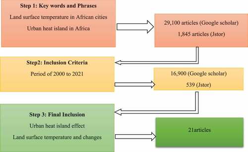
Both literature search was limited further to peer-reviewed articles which span from the year 2000 to 2021. This further reduced the Google Scholar and Jstor search results to sixteen thousand, nine hundred (16,900) and five hundred and thirty-nine (539), respectively. Considering the fact that the literature search was done manually without any special software and adding other search engines makes the entire search complex. The articles were filtered severally for inclusion and returned data were all stored in a referencing database (Mendeley). Titles and abstracts for each article were reviewed to create a list of potentially relevant data. Afterwards, the full text was examined. For an article to be considered relevant, it must examine urban heat island effect or land surface temperature changes. In all, twenty-one (21) articles on African cities were selected after carefully screening the titles and abstracts (refer to Table ). Figure provides geographical location of reviewed articles in Africa. Notwithstanding, there were several other materials reviewed for this paper which were considered relevant although outside the scope of the search. Bearing in mind the rigorous processes in reviewing the various articles, the entire process suffered some lapses in the review process.
Figure 2. Study countries of reviewed articles.
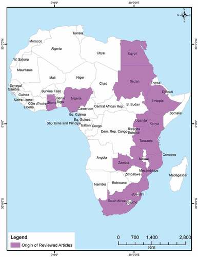
Table 1. Information on reviewed articles in Africa
3. Methodological reviews and positions
Quantitative methodology was majorly employed in the study of urban heat effects. From the systematic review, urban heat effect is mostly studied through surface urban heat island (SUHI; Ningrum, Citation2018; Zhou et al., Citation2019) through observed air temperature (Sobrino et al., Citation2013) but varies in climate, latitude, topography and meteorological conditions (Haashemi et al., Citation2016). Remote sensing and ground-based meteorological stations are the most predominant technique in monitoring UHIE (Ayanlade, Citation2016; Zak, Citation2012; Zhou et al., Citation2019). As noted by Abutaleb et al. (Citation2015), studies on UHI can be carried out using either direct air temperature measurements through networks of weather stations and automobile transects or indirect surface temperature measurements using airborne or satellite remote sensing.
According to Ayanlade (Citation2016), in measuring land surface temperature (LST) the widely used approach can be categorised into two. Thus, the conventional ground dataset and remote sensing data. Whiles the conventional ground method uses data from weather stations that of remote sensing uses satellite-borne data. In studying UHIE, remote sensing has been noted to be the most common since it offers an efficient and faster approach for monitoring spatiotemporal data variation of UHI over a long period (Ayanlade, Citation2016). Also, Land cover-driven indicators helps in explaining UHIE better (Sheng et al., Citation2017). Satellite sensors such as Landsat Thematic Mapper (TM), Enhanced Thematic Mapper Plus (ETM+) and Operational Land Imager (OLI) in some studies is suggested to provide images with medium spatial resolution. To enhance the spatial resolution of other bands, Landsat ETM+ and OLI have panchromatic bands with 15 m spatial resolutions. Interestingly, Landsat OLI images in recent studies produce good results (Phiri & Morgenroth, Citation2017). To maximize societal benefit from satellite data, free and open data policies from Landsat programs have contributed to its continuous success (Zhu et al., Citation2019). Even though Landsat time series data have advanced remote sensing science and applications, it provides less temporal resolution data in monitoring UHIE (Zhu et al., Citation2019). Aside it orbital gaps, cloud contamination is one of the shortfalls of Landsat LST data. Whiles spatiotemporal information has been used to fill gaps, particularly in Landsat data in various studies, Enhanced Hybrid (EH) method which integrates spatiotemporal information and information from other similar LST products has proven to be more robust and accurate (Yao et al., Citation2021). In spite of the orbital gaps and cloud cover limitations from Landsat, Moderate Resolution Imaging Spectroradiometer (MODIS) although has low spatial resolution can close data gaps as it captures images twice daily (WU et al., Citation2008). Hu and Brunsell (Citation2015) and Ayanlade (Citation2016) in their studies noted that MODIS can capture UHI dynamics with low bias.
The remote sensing method is proven to be very effective than the conventional ground method since it covers a wider area. Although the conventional ground method has been noted to be effective only when there are several weather stations within a reasonable distance. It is quite challenging to have accurate and reliable UHIE analysis with meteorological data particularly in Africa (Ayanlade, Citation2016). This reecho the point that in the absence and nonuniform distribution of ground weather stations, remotely sensed data is of great importance to monitor the impact of different environmental issues such as UHI (Abutaleb et al., Citation2015). Other literature emphasizes that the estimation of near-surface air temperature is useful for a wider application in agriculture, climate change and climate health studies where air temperature data are derived from synoptic stations. However, the spatial distribution of these synoptic stations is limited in Africa likewise limiting their use for real-time application (Vancutsem et al., Citation2010). According to Sheng et al. (Citation2017), although Landsat LST-based UHI performs well on high sunny days, weather station temperature-based UHI has a better result during the night following a dry sunny day. This suggests that the UHI effect can be influenced by the selection of data used, acquisition and weather conditions. Therefore in examining UHIE, these are important factors to consider. It is also worth noting that urban heat effect could be influenced by location since results vary with latitude, climate and topography (Haashemi et al., Citation2016). LST is higher in urban areas than in rural areas and much more intense during the daytime in the dry season (Adeyeri et al., Citation2017). Similar to the conclusion by Sheng et al. (Citation2017), studying UHIE intensity using Landsat LST is higher during summer and lower in winter whiles weather station air temperature is at its highest in winter.
Recent publications show a steady application of thermal remote sensing for UHI studies however this method shows slow progress in countries in Africa (Ayanlade, Citation2016). It is again important to note that, temporal dimensions in most cases add as a prerequisite in studying temperate and urban heat effects. For instance, studies by Kruger and Shongwe (Citation2004) employed a time series analysis in studying South African temperatures where temporal and spatial trends were investigated for the period 1960 to 2003.
4. Discussion of outcomes and synthesis
4.1. Causes of UHI in African cities
Most studies observing changes in urban temperature proved that urban areas are getting warmer than rural areas (Ayanlade, Citation2016) as a result of urbanization and other anthropogenic factors such as home and industrial wastes, buildings and construction. Thus, urban growth is found to have a large impact on the local temperature in African cities (Chapman et al., Citation2017; Ningrum, Citation2018). Similar to the views of Hardy and Nel (Citation2015), factors driving UHIE include the high density of buildings and low levels of vegetative cover within populated urban areas. Scientific research has proven that areas with high levels of vegetation are cooler and thus have lower UHIE than less vegetated areas, while built-up areas and densely populated areas are hotter and have higher heat effects (Hardy & Nel, Citation2015; Stewart & Oke, Citation2012). Cavan et al. (Citation2014) in their study in Addis Ababa and Dar es Salaam, indicated that residential urban morphology type (UMT) accounts for the largest surface cover and has a much larger potential to alter neighbourhood level surface temperatures due to the rise in population. This presents a worrying situation in Africa as cities are rapidly expanding due to the increasing population. Within the residential UMT informal settlements and traditional housing account for the lowest land surface temperatures. Along the gradients of four African cities, communities with a higher percentage of impervious surface areas are warmer than those with green spaces (Simwanda et al., Citation2019). In the nutshell, rapid urbanization and land cover changes correlate with an area’s thermal characteristics and changes in major cities in Africa (Mazinyo & Kalumba, Citation2018).
4.2. Health and energy impact of UHI
Higher UHI has several implications not only for urban residents but also for those in small areas (Ayanlade, Citation2016). Such impacts include the risk of heat-related outbreaks (Pascual et al., Citation2017), mortality (Chapman et al., Citation2017) change in thermal comfort and urban microclimate (Ayanlade, Citation2016). It is also evident that temperature and precipitation are significant factors of low birth weight outcomes in Sub-Saharan Africa since the region is heavily dependent on rain-fed agriculture (Grace et al., Citation2015). UHI has significantly increased ambient temperature which has a higher impact on energy consumption (Santamouris et al., Citation2015). Abutaleb et al. (Citation2015) for instance, noted that UHI effect in Egypt has led to electricity cut-off and the demand for more energy load. This influence the well-being and health of urban dwellers, air quality and altered environmental conditions (Lowe, Citation2016). A rise in urban temperature leaves vulnerable populations at risk, especially the active working population (Hanna et al., Citation2011). It is suggested that extreme temperatures are harmful to children since they are more vulnerable to heat partly as a result of their physiological features. Hence, high temperatures could metamorphose into high deaths, especially among foetuses and young children. Likewise, it can make learning more difficult affecting children’s prospects (Zivin & Shrader, Citation2016). Studies in South Africa found an association between daily maximum temperature and mortality (Scovronick et al., Citation2018). Yeeles (Citation2015) also noted that there is notable evidence of urban heat association with urban social conflict in major cities in Africa.
4.3. Mitigation strategies of UHI effect
Findings from land use land cover (LULC) change effect on UHI proves a changing dynamic. This, therefore, calls for urgent green-orientation landscape management methods to mitigate the impact of UHIE (Dissanayake et al., Citation2019). It is important to provide urban heat stress relief by improving urban vegetation to reduce thermal discomfort by increasing air humidity in hot tropical regions such as Africa (Manoli et al., Citation2019). As proposed by Ojeh et al. (Citation2016) there is a need for countries in Africa to develop climate-smart urban planning with decentralized economic activities from the city core. It is also important to maintain urban vegetation to reduce the heat effect. As identified by Ningrum (Citation2018), spatial development planning needs to be employed to control the growth of built-ups with green open spaces. Effat and Hassan (Citation2014) asserted that increasing green vegetation, particularly in the desert eastern parts of Egypt together with proper housing architecture can reduce urban heat islands intensities and heat flux. Also, to improve the thermal environment and mitigate UHI, there is the need for the use of lower absorptive material, higher reflective and larger thermal conductivity of buildings. Völker et al. (Citation2013) in their study noted that the temperature-mitigating capacity of “urban blue” (water) can potentially reduce urban heat effects such as heat stress in the urban spaces (Gunawardena et al., Citation2017). Cool roofs and green roofs are two popular methods to mitigate the urban heat island and improve urban climates (O'Malley et al., Citation2015; Zhang et al., Citation2017). Li, Stringer & Dallimer (Citation2021) highlight topography and construction materials as contributing factors to UHI. However, mitigation strategies such as proving blue and green infrastructure can enhance human comfort in Eastern African cities where UHI effects are highest. Feyisa et al. (Citation2014) in their paper “efficiency of parks in mitigating urban heat island effect in Addis Ababa”, acknowledged that cooling effects are determined by several factors such as species group, canopy cover, size and shape of parks. Therefore, in mitigating urban heat effects through cool and green roofs there is the need to provide insight regarding the importance of species choice and spatial design of green spaces in cooling the environment. It also noted that to reduce thermal discomfort indoors and its associated effect on children, better architectural designs of school buildings, heatwave warning systems coupled with readjusting teaching and learning schedules in schools are important for government consideration (Zivin & Shrader, Citation2016).
5. Conclusions and recommendations
It is interesting to note that, studies on temperature and urban heat effect rely on time series analysis. This provides a clear case of changes in UHIE within a specific period of study. The intensity of UHIE according to the literature varies with population size and mean annual precipitation, but a unifying explanation for this variation is lacking and there are no geographically targeted guidelines for heat mitigation (Manoli et al., Citation2019). The literature is reasonably successful in operationalizing concepts as most studies demonstrate a good conceptual understanding of urban heat effect. Remote sensing and air temperature from weather stations are mostly used in the study of urban heat effects across the world however scholars proposed that in the context of the limited spatial distribution of weather stations particular in Africa the former is recommendable.
From the literature review, it is perceptible that few studies have been done in Africa. Particularly, Southern and Eastern Africa have received some attention on temperature and urban heat effect. Despite this, it could be generally said that research on urban heat effect in Africa as compared to the rest of the world has received little attention as suggested by some studies. There is also not enough openness of methods rather most urban heat effect researchers stick to quantitative methodology. Most papers reviewed employed quantitative research methodology rather than qualitative research methodology or mixed methods. Quantitative research approach has often been criticised for not being very good for explaining behaviours and perceptions since measurements in quantitative research tend to detach findings from real-world contexts. According to scholars, focusing only on quantitative methods does not provide the totality of the picture in studying heat effects as there may be the need for individual perspectives in interpreting heat effects. This review notes that qualitative research methodology or methodological triangulation serves as another option to explore deeply on UHI in African cities (Pasquini et al., Citation2020).
To inform adaptation and mitigation measures, future research should focus on developing counties on which information is currently insufficient, particularly in Africa. More so, most studies have focused much on the outdoor temperature and heat effect with little exploration on indoor temperatures. Since people spend much of their time indoors (Franck et al., Citation2013), recommend the need for indoor temperature assessment, particularly at night time for studies on well-being and health. This can therefore be conducted through mobile sensor devices such as thermometer data loggers (Smargiassi et al., Citation2008). For instance, studies by Wilby et al. (Citation2021) used Tinytag Transit 2 thermistors to monitor air temperatures in two major cities in Ghana.
The various studies revealed that there is epidemiological evidence to support the debate that, surrounding temperature is significantly associated with cause-specific diseases. Therefore, there is a need for extended research in understanding urban heat morbidities. Also, it has been established in the literature that indoor temperature effect has a reciprocating consequence on the health of children and the working population. Therefore, the call for much studies on thermal comfort of buildings is worth exploring in examining temperature intensity and heat urban effect in places of occupancy.
Disclosure statement
No potential conflict of interest was reported by the author(s).
Additional information
Funding
Notes on contributors
Ronald Reagan Gyimah
Ronald Reagan Gyimah is a Doctoral Candidate in Geography and Resource Development at the University of Ghana, Legon. His research interest includes climate change, environmental health, urban studies, disaster risk reduction and agriculture.
References
- Abutaleb, K., Ngie, A., Darwish, A., Ahmed, M., Arafat, S., & Ahmed, F. (2015). Assessment of Urban Heat Island using remotely sensed imagery over Greater Cairo, Egypt. March, 35–11. https://doi.org/10.4236/ars.2015.41004
- Adeyeri, O. E., Akinsanola, A. A., & Ishola, K. A. (2017). Investigating surface urban heat island characteristics over Abuja, Nigeria: Relationship between land surface temperature and multiple vegetation indices. Remote Sensing Applications: Society and Environment, 7(June), 57–68. https://doi.org/10.1016/j.rsase.2017.06.005
- Ayanlade, A. (2016). Science of the total environment seasonality in the daytime and night-time intensity of land surface temperature in a tropical city area. Science of the Total Environment, The, 557– 558, 415–424. https://doi.org/10.1016/j.scitotenv.2016.03.027
- Bhargava, A., Lakmini, S., & Bhargava, S. (2017). Urban heat Island effect: It’s relevance in urban planning. Journal of Biodiversity & Endangered Species, 05(2), 1–4. https://doi.org/10.4172/2332-2543.1000187
- Cavan, G., Lindley, S., Jalayer, F., Yeshitela, K., Pauleit, S., Renner, F., Gill, S., Capuano, P., Nebebe, A., Woldegerima, T., Kibassa, D., & Shemdoe, R. (2014). Urban morphological determinants of temperature regulating ecosystem services in two African cities. Ecological Indicators, 42, 43–57. https://doi.org/10.1016/j.ecolind.2014.01.025
- Chapman, S., Watson, J. E. M., Salazar, A., Thatcher, M., & McAlpine, C. A. (2017). The impact of urbanization and climate change on urban temperatures: A systematic review. Landscape Ecology, 32(10), 1921–1935. https://doi.org/10.1007/s10980-017-0561-4
- Clinton, N., & Gong, P. (2013). Remote sensing of environment MODIS detected surface urban heat islands and sinks : Global locations and controls. Remote Sensing of Environment, 134, 294–304. https://doi.org/10.1016/j.rse.2013.03.008
- Codjoe, S. N. A., Gough, K. V., Wilby, R. L., Kasei, R., Yankson, P. W. K., Amankwaa, E. F., Abarike, M. A., Atiglo, D. Y., Kayaga, S., Mensah, P., Nabilse, C. K., & Griffiths, P. L. (2020). Impact of extreme weather conditions on healthcare provision in urban Ghana. Social Science and Medicine, 258(March), 113072. https://doi.org/10.1016/j.socscimed.2020.113072
- Davoudi, S., & Stead, D. (2002). Urban-rural relationships: An introduction and brief history. Built Environment Journal, 28(4), 269–277. https://eprints.ncl.ac.uk/file_store/production/56174/F20B4906-85CC-421B-B18C-51B26D56E181.pdf
- Dissanayake, D. M. S. L. B., Morimoto, T., Ranagalage, M., & Murayama, Y. (2019). Land-use/land-cover changes and their impact on surface urban heat islands: Case study of Kandy City, Sri Lanka. Climate, 7(8), 1–20. https://doi.org/10.3390/cli7080099
- Effat, H. A., & Hassan, K. A. O. (2014). Urban climate change detection of urban heat islands and some related parameters using multi-temporal Landsat images ; a case study for Cairo city, Egypt. Urban Climate, 10, 171–188. https://doi.org/10.1016/j.uclim.2014.10.011
- Feyisa, G. L., Dons, K., & Meilby, H. (2014). Landscape and Urban planning efficiency of parks in mitigating urban heat island effect : An example from Addis Ababa. Landscape and Urban Planning, 123, 87–95. https://doi.org/10.1016/j.landurbplan.2013.12.008
- Franck, U., Krüger, M., Schwarz, N., Grossmann, K., Röder, S., & Schlink, U. (2013). Heat stress in urban areas : Indoor and outdoor temperatures in different urban structure types and subjectively reported well-being during a heat wave in the city of Leipzig. Meteorologische Zeitschrift, 22(2), 167–177. https://doi.org/10.1127/0941-2948/2013/0384
- Giridharan, R., & Emmanuel, R. (2018). The impact of urban compactness, comfort strategies and energy consumption on tropical urban heat island intensity: A review. Sustainable Cities and Society, 40, 677–687. https://doi.org/10.1016/j.scs.2018.01.024
- Grace, K. , Davenport, F., Hanson, H., Funk, C., & Shukla, S. (2015). Linking climate change and health outcomes : Examining the relationship between temperature, precipitation and birth weight in Africa. Global Environmental Change, 35, 125–137. https://doi.org/10.1016/j.gloenvcha.2015.06.010
- Gunawardena, K. R., Wells, M. J., & Kershaw, T. (2017). Science of the total environment utilising green and bluespace to mitigate urban heat island intensity. Science of the Total Environment, 584– 585, 1040–1055. https://doi.org/10.1016/j.scitotenv.2017.01.158
- Haashemi, S., Weng, Q., Darvishi, A., & Alavipanah, S. K. (2016). Seasonal variations of the surface Urban heat Island in a Semi-Arid City. Remote Sensing, 8(4), 352. https://doi.org/10.3390/rs8040352
- Hanna, E. G., Kjellstrom, T., Bennett, C., & Dear, K. (2011). Climate change and rising heat: Population health implications for working people in Australia. Asia-Pacific Journal of Public Health, 23(2), 14S–26S. https://doi.org/10.1177/1010539510391457
- Hardy, C. H., & Nel, A. L. (2015). Data and techniques for studying the urban heat island effect in Johannesburg. International Archives of the Photogrammetry, Remote Sensing and Spatial Information Sciences - ISPRS Archives, 40(7W3), 203–206. https://doi.org/10.5194/isprsarchives-XL-7-W3-203-2015
- Herbel, I., Croitoru, A. E., Rus, I., Harpa, G. V., & Ciupertea, A. F. (2016). Detection of atmospheric urban heat island through direct measurements in Cluj-Napoca city, Romania. Hungarian Geographical Bulletin, 65(2), 117–218. https://doi.org/10.15201/hungeobull.65.2.3
- Hu, L., & Brunsell, N. A. (2015). A new perspective to assess the urban heat island through remotely sensed atmospheric profiles. Remote Sensing of Environment, 158, 393–406. https://doi.org/10.1016/j.rse.2014.10.022
- Kimuku, C. W., & Ngigi, M. (2017). Study of Urban Heat Island trends to aid in Urban planning in Nakuru County-Kenya (pp. 309–325). https://doi.org/10.4236/jgis.2017.93019
- King’uyu, S. M., Ogallo, L. A., & Anyamba, E. K. (2000). Recent trends of minimum and maximum surface temperatures over Eastern Africa. Journal of Climate, 13(16), 2876–2886. https://doi.org/10.1175/1520-0442(2000)013<2876:RTOMAM>2.0.CO;2
- Kruger, A. C., & Shongwe, S. (2004). Temperature trends in South Africa : 1960 – 2003. 1945, 1929–1945. https://doi.org/10.1002/joc.1096
- Li, X., Stringer, L. C., & Dallimer, M. (2021). The spatial and temporal characteristics of Urban heat Island intensity : Implications for East Africa ’ s Urban development. Climate, 9(4), 51. https://doi.org/10.3390/cli9040051
- Lowe, S. A. (2016). An energy and mortality impact assessment of the urban heat island in the US. Environmental impact assessment review, 56, 139–144. https://doi.org/10.1016/j.eiar.2015.10.004 Mathworks.com
- MacKellar, N., New, M., & Jack, C. (2014). Climate trends in South Africa observed and modelled trends in rainfall and temperature for South Africa : 1960 – 2010. South African Journal of Science, 110(7), 1–13. https://doi.org/10.1590/sajs.2014/20130353
- Manoli, G., Fatichi, S., Schläpfer, M., Yu, K., Crowther, T. W., Meili, N., Burlando, P., Katul, G. G., & Bou-Zeid, E. (2019). Magnitude of urban heat islands largely explained by climate and population. Nature, 573(7772), 55–60. https://doi.org/10.1038/s41586-019-1512-9
- Mazinyo, I. R. O. S. P., & Kalumba, W. N. A. M. (2018). Spatiotemporal monitoring of land surface temperature and estimated radiation using remote sensing : Human health implications for East London, South Africa. Environmental Earth Sciences, 1–10. https://doi.org/10.1007/s12665-018-7252-6
- Mccarthy, M. P., Best, M. J., & Betts, R. A. (2010). Climate change in cities due to global warming and urban effects. 37, 1–5. https://doi.org/10.1029/2010GL042845
- Missirian, A., & Schlenker, W. (2017). Asylum applications respond to temperature fluctuations. 1614(December), 1610–1614. https://science.sciencemag.org/content/358/6370/1610
- Ngie, A., Abutaleb, K., Ahmed, F., Darwish, A., & Ahmed, M. (2014). Assessment of urban heat island using satellite remotely sensed imagery : A review. South African Geographical Journal, 97(2), 198–214. https://hdl.handle.net/10520/EJC160382
- Ningrum, W. (2018). Urban Heat Island towards Urban Climate. IOP Conference Series: Earth and Environmental Science, 118(1). https://doi.org/10.1088/1755-1315/118/1/012048
- Ojeh, V. N., Balogun, A. A., & Okhimamhe, A. A. (2016). Urban-rural temperature differences in Lagos. Climate, 4(2), 1–18. 10.3390/cli4020029
- O'Malley, C., Piroozfar, P., Farr, E. R. P., & Pomponi, F. (2015). Urban Heat Island (UHI) mitigating strategies : A case-based comparative analysis. Sustainable Cities and Society, 19, 222–235. https://doi.org/10.1016/j.scs.2015.05.009
- Pascual, M., Bouma, M. J., Pascual, M., & Bouma, M. J. (2017). Do rising temperatures matter ? Published by : Wiley on behalf of the ecological society of America stable REFERENCES Linked references are available on JSTOR for this article : You may need to log in to JSTOR to. 90(4), 906–912. https://www.jstor.org/stable/25592577
- Pasquini, L., Aardenne, L., Van, Nicole, C., Lee, J., & Jack, C. (2020). Science of the Total Environment Emerging climate change-related public health challenges in Africa : A case study of the heat-health vulnerability of informal settlement resi- dents in Dar es Salaam, Tanzania. Science of the Total Environment, 747, 141355. https://doi.org/10.1016/j.scitotenv.2020.141355
- Phiri, D., & Morgenroth, J. (2017). Developments in Landsat land cover classification methods : A review. Remote Sensing, 9(9), 967. https://doi.org/10.3390/rs9090967
- Santamouris, M., Cartalis, C., Synnefa, A., & Kolokotsa, D. (2015). On the impact of urban heat island and global warming on the power demand and electricity consumption of buildings — A review. Energy & Buildings, 98, 119–124. https://doi.org/10.1016/j.enbuild.2014.09.052
- Scovronick, N., Sera, F., Acquaotta, F., Garzena, D., Fratianni, S., Wright, C. Y., & Gasparrini, A. (2018). The association between ambient temperature and mortality in South Africa : A time-series analysis. Environmental Research, 161(September 2017), 229–235. https://doi.org/10.1016/j.envres.2017.11.001
- Sheng, L., Tang, X., You, H., Gu, Q., & Hu, H. (2017). Comparison of the urban heat island intensity quantified by using air temperature and Landsat land surface temperature in Hangzhou. Ecological Indicators, 72, 738–746. https://doi.org/10.1016/j.ecolind.2016.09.009
- Simwanda, M., Ranagalage, M., Estoque, R. C., & Murayama, Y. (2019). Spatial analysis of surface urban heat Islands in four rapidly growing African cities. Remote Sensing, 11(14), 1–20. https://doi.org/10.3390/rs11141645
- Smargiassi, A., Fournier, M., Griot, C., Baudouin, Y., & Kasatsky, T. (2008). Prediction of the indoor temperatures of an urban area with an in-time regression mapping approach. Journal of Exposure Science and Environmental Epidemiology, 18(3), 282–288. https://doi.org/10.1038/sj.jes.7500588
- Sobrino, J. A., Oltra-carrió, R., Sòria, G., Jiménez-Muñoz, J. C., Franch, B., Hidalgo, V., Mattar, C., Julien, Y., Cuenca, J, Romaguera, M., Gómez, J. A., De Miguel, E., Bianchi, R, Paganini, M. . (2013). Evaluation of the surface urban heat island effect in the city of Madrid by thermal remote sensing, 1161. https://doi.org/10.1080/01431161.2012.716548
- Stewart, I. D. (2007). Landscape representation and the urban-rural dichotomy in empirical urban heat island literature, 1950–2006. Acta Climatologica Et Chorologica, 40(41), 111–121. https://www2.sci.u-szeged.hu/eghajlattan/akta07/111-121.pdf
- Stewart, I. D. (2011). A systematic review and scientific critique of methodology in modern urban heat island literature. 217(April 2010), 200–217. https://doi.org/10.1002/joc.2141
- Stewart, I. D., & Oke, T. R. (2012). Local climate zones for Urban temperature studies. American Meteorological Society, 93(12), 1879–1900. https://doi.org/10.1175/BAMS-D-11-00019.1
- Vancutsem, C., Ceccato, P., Dinku, T., & Connor, S. J. (2010). Remote sensing of environment evaluation of MODIS land surface temperature data to estimate air temperature in different ecosystems over Africa. Remote Sensing of Environment, 114(2), 449–465. https://doi.org/10.1016/j.rse.2009.10.002
- Völker, S., Baumeister, H., Claßen, T., Hornberg, C., & Kistemann, T. (2013). Evidence for the temperature-mitigating capacity of urban blue space - A health geographic perspective. Erdkunde, 67(4), 355–371. https://www.jstor.org/stable/23595377
- Wilby, R. L., Kasei, R., Gough, K. V., Amankwaa, E. F., Abarike, M., Anderson, N. J., Codjoe, S. N. A., Griffiths, P., Kaba, C., Abdullah, K., Kayaga, S., Matthews, T., Mensah, P., Murphy, C., & Yankson, P. W. K. (2021). Monitoring and moderating extreme indoor temperatures in low-income urban communities. Environmental Research Letters, 16(2), 024033. https://doi.org/10.1088/1748-9326/abdbf2
- WU, G., Leeuw, J. D. E., Skidmore, A. K., Prins, H. H. T., & Y, L. I. U. (2008). Comparison of MODIS and Landsat TM5 images for mapping tempo–spatial dynamics of secchi disk depths in Poyang Lake National nature reserve, China. International Journal of Remote Sensing, April, 29(8), 2183–2198. https://doi.org/10.1080/01431160701422254
- Yao, R., Wang, L., Huang, X., Sun, L., Chen, R., Wu, X., Zhang, W., & Niu, Z. (2021). A robust method for filling the gaps in MODIS and VIIRS land surface temperature data. IEEE Transactions on Geoscience and Remote Sensing, 59(12), 10738–10752. https://doi.org/10.1109/TGRS.2021.3053284
- Yeeles, A. (2015). Weathering unrest : The ecology of urban social disturbances in Africa and Asia. Journal of Peace Research, 52(2), 158–170. https://doi.org/10.1177/0022343314557508
- Ye, X., Wolff, R., Yu, W., Vaněčkova, P., Pan, X., & Tong, S. (2012). Ambient temperature and morbidity : A review of epidemiological evidence author (s): Xiaofang Ye, Rodney Wolff, Weiwei Yu, Pavla Vaneckova, Xiaochuan Pan and Published by : The national institute of environmental health sciences stable. Environmental Health Perspectives, 120(1), 19–28. https://doi.org/10.1289/ehp.1003198
- Zak, K. (2012). Remote Sensing of Environment Downscaling land surface temperature for urban heat island diurnal cycle analysis. 117, 114–124. https://doi.org/10.1016/j.rse.2011.05.027
- Zele, M., Purcz, P., Hlavatá, H., & Bliš, P. (2015). Climate change in urban versus rural areas. 119, 1171–1180. https://doi.org/10.1016/j.proeng.2015.08.968
- Zhang, N., Chen, Y., Luo, L., & Wang, Y. (2017). Effectiveness of different Urban Heat Island mitigation methods and their regional impacts. American Meteorological Society, 18(11), 2991–3012. https://doi.org/10.1175/JHM-D-17-0049.1
- Zhou, D., Xiao, J., Bonafoni, S., Berger, C., Deilami, K., Zhou, Y., Frolking, S., Yao, R., Qiao, Z., & Sobrino, J. A. (2019). Satellite remote sensing of surface Urban Heat Islands : progress. Challenges, and Perspectives. 1–36. https://doi.org/10.3390/rs11010048
- Zhu, Z., Wulder, M. A., Roy, D. P., Woodcock, C. E., Hansen, M. C., Radelo, V. C., Healey, S. P., Schaaf, C., Hostert, P., Strobl, P., Pekel, J., Lymburner, L., Pahlevan, N., & Scambos, T. A. (2019). Remote sensing of environment bene fi ts of the free and open Landsat data policy. 224(January), 382–385. https://doi.org/10.1016/j.rse.2019.02.016
- Zivin, J. G., & Shrader, J. (2016). Temperature extremes, health, and human capital. 26(1), 31–50. https://www.jstor.org/stable/43755229
