
Abstract
The purpose of this study was to ascertain the existing level of geographic understanding and the ability to integrate geographic considerations into investigations within the police (without prior training on geographic profiling) at two different levels of investigative experience, compared to professional geographic profilers. Three groups of investigative professionals - geographic profilers (geos), detective constables (DCs) and probationary police constables (PCs) - were given a simulation case that deals with a real series of potentially linked cases of arson. During these individual simulation interviews, qualitative data on participants’ verbal utterances and vocalised thought processes was recorded, then analysed and quantified. Both the quantity of investigative statements made as well as their content and quality were scrutinised. Quantitatively, the DC and geo groups were almost identical in terms of how many investigative considerations they made in relation to geographic and temporal (related to time of day, day of the week, etc.) aspects of a crime. However, qualitative analysis revealed a gap in the level of understanding of the importance of some geographic considerations between geos and the police. Overall, the research concludes that police investigators are a very fertile ground for receiving training on geographic profiling, as some of it is already naturally integrated into their investigations, and that increasing investigators’ understanding of geographic profiling could enhance their operational capabilities in the thousands of cases in which no expert geographic profiler is brought in to support them.
REVIEWING EDITOR:
Introduction
Criminological application of geographic profiling
In an investigative context, geographic profiling (GP) uses temporal and spatial information to suggest how, where and when best to catch an offender, either in the act or by narrowing search parameters and/or prioritising suspects for investigation based on their home address or other anchor sites. Originally, it was mainly seen as a tool to prioritise long lists of nominals in serial crimes, including murder (Aygin et al., Citation2021; Stevens et al., Citation2020). This can be achieved by identifying the users of certain routes at certain times, the movements of offenders and victims before, during and after an offence, as well as identifying temporal and spatial patterns in offending (mainly in serial cases). GP is based on the premise that the locations of crimes are not random but carry a ‘degree of underlying spatial structure’, as there is some rationality behind the selection of their locations by offenders (Rossmo, Citation1995, p. 222). Research into spatial patterns of offending has shown that the further a location is from the offender’s home, the less likely it is to be chosen as a crime site, therefore forming a distance-decay pattern (Rhodes & Conly, Citation1981). It has also been shown that offenders travel shorter distances to commit crimes of violence than to commit acquisitive crimes (Amir, Citation1971). Older stranger rapists tend to commit offences somewhat further away from home than younger men (Davies & Dale, Citation1995), whilst it has also been found that rapists tend to travel further on weekends to attack a victim than during the week (Canter & Gregory, Citation1994), but again less during the night time (Warren et al., Citation1995). Geographic profiling is often defined too narrowly as a suspect prioritisation tool only in serial crime investigations, when in fact it offers a lot more than that and can be applied in single cases (Knabe, Citation2008; see also definition below). Nevertheless, it did start out (in modern times) with the attempt to narrow down search efforts in the Yorkshire Ripper serial murder investigation in the late 1970s in the UK, which had produced 268,000 names of potential suspects and 5.4 million car registration numbers (Doney, Citation1990). Furthermore, an unpublished study (Knabe, Citation2008) suggests that geoprofilers (also referred to as geographic profilers or geos throughout this article) can be utilised to aid in a criminal investigation in single cases as well as serial cases: Geographic profiling is a technique that uses temporal and spatial information to suggest how, where and when best to catch an offender. This is done for instance by identifying the movements of offenders and victims before, during and after an offence, as well as temporal and spatial patterns in offending. The resulting information can often help in determining how familiar the offender is likely to have been with the victim and the area, which can assist in focusing lines of inquiry. Furthermore, geographic profilers aim to identify how the offender targeted, chose, and attacked their victim(s). This in turn may inform investigative strategies in terms of how and where to deploy surveillance, initiate decoy operations, conduct house-to-house enquiries, appeal for information, conduct DNA screens, and focus search efforts, amongst other things (Knabe, Citation2008).
GP in the UK has been undertaken by experts, named geographic profilers, since 1999 at what was then the National Crime Faculty. In 2007, that organisation was renamed the National Policing Improvement Agency (NPIA), which in 2012 was absorbed by the Serious Organised Crime Agency (SOCA), which in turn was split into the National Crime Agency (NCA) and the College of Policing in 2013. With the UK and its public service organisations having undergone a major financial crisis and resulting budget cuts, since April 2015 there has been only one geo remaining at the NCA, down from four. This drastic reduction in operational capability and how much geographic profiling can be offered to police forces makes it even more relevant to examine whether at least some of such geographic understanding is somehow already ingrained in everyday policing. Alternatively, GP experts would be indispensable for a thorough and informed geographic and temporal analysis of a serious and/or complex crime. Every police force in the UK is able to request the geo’s investigative support for their case through the NCA, free of charge. This tends to happen only in the most complex and serious cases however, leaving the overwhelming majority of investigations without this expert geographic input.
Whilst police officers are concerned mainly with obtaining evidence, geographic profilers focus on using crime information to extract behavioural information of a geographic and temporal nature and crystallising some of the decision-making processes of the offender’s. This can then lead to drawing up hypotheses about the perpetrator’s knowledge of the victim or the area, their choice of transport and routes, etc. GP is also used to predict future crime and its locations. For instance, it has been applied to efficiently plan police patrols (days, times and routes) in Memphis, USA, to coincide with where and when offences are most likely to happen, which is said to have resulted in a 16% drop in crime between 2006 and 2008 (Perry et al., Citation2012). In England, a geo was able to direct a police decoy operation in a serial stranger rape case in an English town that successfully caught the offender as he tried to attack an officer presenting as a potential victim in what would be his next rape (Daniell, Citation2008). Whilst the crime locations had been the victim’s home addresses and therefore were unrelated to the offender’s geography, the geo had realised that when the previous victims had all walked home from a night out through a certain area of town, they had gone through the offender’s hunting ground where he was driving around looking for a lone female walking and then followed her to her home from there. That hunting ground was where the decoy officer walked through, where she was spotted by the offender and he then tried to attack her as she entered the safe house (Daniell, Citation2008). The vast majority of police investigations in the UK do not receive the assistance of a geographic profiler. The extent of the impact of that void in assistance is unknown, and is one of the reasons this research is vital – what is the existing geographic profiling capability within UK policing?
Theoretical underpinnings
Geographic profiling (GP) is a technique that uses behavioural information on how offenders make decisions about where to offend, how to get there and when, in order to inform investigations and identify or prioritise suspects for serious and/or serial offences. It is based on the realisation that underlying crime and criminal activities is a level of rationality influencing the geography of offending (Berezowski et al., Citation2023). GP is used to model offenders’ travel characteristics and identify the factors that influence target choices (Mburu & Helbich, Citation2015), amongst other things. It can identify possible anchor points or a base of the offender’s (e.g. the place where they live, where they spend much of their time such as a partner’s home, or where s/he works, etc.,), as well as illuminate which other possible crime locations are on their mental map of awareness.
A detailed analysis of geographic observations can be utilised in many ways. Perhaps one of the first documented applications of GP took place in 1854 (Snow, Citation1855). John Snow, a physician, meticulously went through hospital and public records and gathered information on where people were getting their drinking water from in London’s Soho, where hundreds were dying of cholera. He painstakingly charted on a map people’s water use routines, water deliveries and public pump uses as well as deaths. In doing so, he managed to trace the source of the infection back to a single water pump on Broad Street, as this had been used in one way or another by all those who had died in the area from that outbreak. When Snow got the authorities to remove the handle of the pump so it could no longer be used, the number of deaths dropped drastically, as the contaminated water could no longer be extracted from the pump (Tuthill, Citation2003). It was not until the early 1980s however, that analyses of geographic behaviour were put into a criminal context by the Brantinghams, who wrote about criminal decision-making in relation to statistical geographic observations (Brantingham & Brantingham, Citation1981). A few years later, Dr Stuart Kind used the crime locations of British serial killer Peter Sutcliffe, aka the Yorkshire Ripper, to make accurate inferences about where the Ripper might live (Kind, Citation1987). Such inferences were made possible by the understanding and application of various behavioural-geographic phenomena which now constitute the theoretical basis of GP. These include routine activity theory, rational choice theory, the least-effort principle, distance decay, the marauder/commuter typologies and the circle hypothesis, all discussed below (Brantingham & Brantingham, Citation1981; Brantingham & Brantingham, Citation1984; Rossmo, Citation2000; Cornish, Citation1993; Reber, Citation1985; Godwin, Citation1996; Canter & Larkin, Citation1993).
Routine activity theory suggests that crime stems in part from legitimate every-day activities (Cohen & Felson, Citation1979; Rossmo, Citation2000), and that offenders identify potential targets or crime sites whilst pursuing unrelated routines, such as travelling to/from work, to/from shops, visiting acquaintances, as well as just walking or driving from one place to another, for instance (Brantingham & Brantingham, Citation1981). Routine activities over time form cognitive maps of spaces in which the person or offender feels comfortable and secure (Brantingham & Brantingham, Citation2008). It is therefore a main focus within GP to identify to which extent an offender was familiar with the area of and around the crime site, as that might indicate whether s/he lives or works in that area or otherwise frequents it. If that seems likely, nominals with a base (e.g. a home address) within that area can be prioritised for investigation.
Closely linked to this is crime pattern theory, which stipulates that offences occur where opportunities to do so coincide with perpetrators’ awareness spaces and around their activity nodes, specific places they get to know during their legitimate everyday activities (Brantingham & Brantingham, Citation1991, Citation1993). Further categorising places within the awareness space to evaluate potential future crime sites, offenders tend to commit offences in locations on which they have reliable information that is relevant to the particular crime in question (Curtis-Ham et al., Citation2020). For example, having frequented a location several times provides reliable information on that place, whilst having successfully offended in an area increases its relevance as a future crime location (Curtis-Ham et al., Citation2020).
Rational choice theory comes into play particularly in pre-meditated offences, as it describes the principle that offenders, like others, make deliberate, rational choices considering the effort required as well as anticipated costs and rewards of any potential criminal activity (Cornish, Citation1993). However, when the offence or any part thereof is less planned-out, such as is the case in a more spontaneous or unexpected situation, decisions become more impulsive than rational with added time-pressure and more immediate consequences (Herrnstein, Citation1990). Some crimes are committed in a state of sudden emotional upheaval and are thus less subject to this theory, however most serial crimes are pre-planned and can therefore be examined using this principle (Chainey & Ratcliffe, Citation2005; Brantingham & Brantingham, Citation2008).
The least-effort principle is crucial when a geographic profiler attempts to determine the route(s) an offender took to or from a crime location for instance, as the principle predicts that offenders will always choose the easiest feasible option (all other aspects being equal), based on an intuitive calculation of effort (Reber, Citation1985). Therefore, an offender can be expected, when faced with at least one alternative and all other factors being equal, to choose the route or option that requires the least effort to take.
A calculation of efforts versus reward also forms the basis of the next GP concept, the distance decay theory, which postulates that, beyond a buffer zone around their home location in which they tend not to offend (Stevenson et al., Citation2012), criminals choose a decreasing amount of targets the further away from their base these locations are. In general, it has been shown that serial offenders tend not to travel beyond 3.2 km from their home location in order to offend (Warren et al., Citation1995; Snook et al., Citation2004). Brantingham and Brantingham (Citation1984) noted this generic negative correlation of distance from home and number of activities carried out in everyday life, such as shopping, leisure and social activities, in a generic context. In a criminal context, this would predict that the further away from the offender’s base potential offence targets are, the less likely they are to be selected as such. Even pirates from the 17th and 18th century have been shown to have committed their attacks according to the distance decay principle (Górski, Citation2022).
The marauder/commuter typology was developed following observations of two broad kinds of geographic criminal behaviour: Marauders are those offenders who leave their home base, offend relatively closely to their home, and return to their place of residence (Canter & Larkin, Citation1993). They might commit offences in any direction away from their home location (though not offending in a zone immediately surrounding their base for fear of being recognised) and can therefore create a somewhat circular pattern around their home address of offences scattered therein, with a frequency that decreases as locations are further away from their base (distance decay). On the other hand, the commuter is an offender who deliberately travels a considerable distance in order to offend, and might actually create a finite pattern of offences that is distinctly separate and removed from their home location (Canter & Larkin, Citation1993). They might return home as well after offending or offend several times within that crime ground, but, unlike with marauders, that offending area will not include their home location (Meaney, Citation2004).
Marauders’ behaviour is further predicted by the circle hypothesis, which observed that a cluster of serial offences can be used to extrapolate the location of the offender’s base by drawing a circle which has as its diameter an imaginary line that connects the two offences of the series that are the furthest from each other (Canter & Larkin, Citation1993; Kocsis & Irwin, Citation1997; Tamura & Suzuki, Citation1997). It should be noted that the circle hypothesis does not apply to commuter offenders as their offending ground is completely separate from their home base (Rossmo, Citation2000).
Some of these basic GP principles were translated into algorithms in order to develop software that would display on a map the most likely area of a serial offender’s residence, based on the locations of a series of connected crimes, such as Rigel (developed by D. Kim Rossmo), CrimeStat (Levine & Associates, 2000) and Dragnet (Canter et al., Citation2000). However, it has been shown that by simply imparting two of these theories that form the basis of geographic profiling, namely the distance decay theory and the circle hypothesis, students were able to predict offenders’ home locations just as well as Dragnet (Snook et al., Citation2002) and CrimeStat (Snook et al., Citation2004). A more modern software system has been developed that maps offenders’ known activity locations including home address, arrest and other incident locations as well as family members’ home addresses, to assist in suspect prioritisation (Curtis-Ham et al., Citation2022). It should be noted however, that predicting the possible home location of an unknown offender is but one of the many uses of geographic profiling, which incorporates a lot more expertise in criminal and human behaviour than can at present be handed over to software (Knabe, Citation2008). This current research does not deal with GP from an algorithmic perspective, which is often used to produce probability/likelihood or ‘jeopardy’ surfaces of likely anchor point locations on a computer screen. Rather, it deals with the qualitative and cognitive aspects and the resulting investigative decision-making processes of GP. Whilst earlier research efforts on GP focused mainly on the distance between home addresses and crime locations, more recently it has been found that neighbourhood-level factors such as what the make-up of the area is (i.e. residential, rural, industrial, affluent, deprived, etc.) also has an impact on the distances travelled to commit offences and the offender’s decision-making (Hirama et al., Citation2023).
Current research: geographic considerations by the police
This pilot study was conducted to ascertain the level of geographical considerations in police officers’ investigative decision-making in a non-metropolitan UK police force. Their investigative considerations were compared with those of specialist geographic profilers in terms of both quantity and quality, in order to gauge the existing level of understanding of geographic-behavioural principles of offending within the police without prior training on anything GP-related. Gaining an insight into police officers’ geographic considerations is essential, as the overwhelming majority of investigations do not incorporate the services of a geo, meaning that it is up to the police to recognise, interpret and then utilise spatial and temporal information to understand an offender’s geographic decision-making process. Yet it is currently not known whether, or to what extent, the police do so. In other comparisons of novices and experts, various differences have been identified between those two categories. For instance, when describing medical images, novices tended to describe basic objects whilst experts described more high-level attributes which require diagnostic knowledge and high reasoning (Wang et al., Citation2012). In the field of crime scene examination, it was also identified that novices paid attention to individual objects generally, whereas experts focused only on objects with evidential value (Baber & Butler, Citation2012) but also attempted to reconstruct the likely actions of the perpetrator in order to guide further search for evidential clues (Schraagen & Leijenhorst, Citation2001). Experts’ processing of information appears to be more high-level and in the context of the big picture, anticipating what can be done with the information gathered further down the line of the investigative process. This was suggested by Baber and Butler (Citation2012), who found that experts considered the analysis of evidence found at a crime scene following its examination, whereas novices focused on the objects present at the scene. Furthermore, experts tend to be able to identify general patterns in evidence rather than focusing on specific instances (McRobert et al., Citation2009; Raab & Johnson, Citation2007). They are also able to better identify where evidential materials might be recovered from (Baber, Citation2010). Collectively, these studies suggest that novices and experts both process and utilise information differently. The cognitive processes when considering geographic information in investigative contexts in geos and police have not been compared before. This study therefore aims to make a first step towards filling that gap.
Method
Participants
As the original expert group was very small, consisting of the only four geos in the UK at the time their data was collected, the police comparison groups were also kept to four each. As one of the geos had been involved in sourcing the materials used in this study which he was thus familiar with however, his data was excluded from the analysis to ensure the study materials were new to each participant. Another reason for small samples was the fact that cognitive extraction processes are very resource-intensive and therefore not suitable for larger samples, unless you have a team of researchers. The geos’ data was originally collected as part of an in-depth piece of research on the expertise of geographic profiling per se that has been published elsewhere (Knabe-Nicol & Alison, Citation2011), and is used in this research as a comparison set to the police officers’ data. At the time, the geos were employed by the NPIA, the operational arm of which became the NCA and now employs the one remaining geographic profiler. The following demographic data is based on the full set of four Geos as the paper records are no longer available to extract any one of them and their data could therefore not be separated, however only three geos were used in this research. Their ages ranged from 31 to 51, with the mean age being 45. There was one female and three males, all holding academic qualifications at Bachelor or Master level. They had an average of 24 years of operational police-related experience. They were qualified geographic profilers accredited by the International Criminal Investigative Analysis Fellowship with an average of 6 years’ experience as a geographic profiler.
Eight police officers were recruited for this pilot study as comparison groups to the geos. Four detective constables (DCs) and four probationer police constables (PCs) from a non-Metropolitan British police force took part in this research. The DCs were embedded within the criminal investigation department (CID) dealing with robberies, burglaries, serious assaults and other serious crimes, or in the major investigation team (MIT), dealing with murders, stranger rapes and other major incidents. The probationers were novice police officers who had completed their 16-week in-house police officer training and were still within their 2-year probationary period. During this time, they are not yet fully qualified, do not respond to incidents single-crewed and are closely supervised by a mentor (a more experienced PC on their team). All four probationers were female, their ages ranging from 24 to 30 years with their mean age being 27. They had an average of 15 months’ worth of operational police experience. Their highest academic qualifications ranged from GCSEs to a Bachelor’s degree. The detective group comprised two females and two males, their ages ranging from 34 to 41 years, the mean age being 38. Between them, they had an average of 10 years’ worth of operational experience. Their highest academic qualifications ranged from an NVQ in Policing to a Master’s degree. All eight police participants stated they had no understanding of geographic profiling when asked at the beginning of the interview, but 37% of them stated that they had heard of it. Mutually convenient times were arranged for the researcher to meet face-to-face with each police officer separately to take them through the simulation interview.
Procedure
The geos’ data was originally collected using the entire Applied Cognitive Task Analysis (ACTA, developed by Klein Associates Inc., Militello et al., Citation1997) process, which is an intensive 3-step procedure - the creation of a task diagram followed by a knowledge audit, and finally, the particiant is taken through a simulation interview. The data from the 3rd step only, the geos’ simulation interview, was used for this research, with the two police groups later also having been taken through the simulation interview to allow for a direct comparison.
For that case simulation, participants were presented with three documents relating to a real-life investigation of a series of arsons, which had been provided by the Serious Crime Analysis Section (SCAS) at the NPIA through one of the four geos, who could therefore not be included in this research. For the arson series, one document showed a numbered list of eight offences of arson in tabular format, the date or date range during which they were committed (e.g., ‘Mon/Tues, 14.04.08/15.04.08’), the time or time range during which they were committed (e.g., ‘22.30–07.30 hours’), the location, which was a residential address, and a very basic description of a modus operandi (MO, e.g., ‘Burnt fast food container put into letterbox’). There was no guidance given to participants as to whether those arson offences were linked (committed by the same offender) or not. Some of the target locations featured twice in the list (i.e., they were repeat victims). The second document showed a map of a small network of residential roads with the five different crime locations featured in the list on the first document marked with the numbers 1–5, although these numbers were not in the chronological order of the offence dates. The third document showed an aerial/satellite image map of the same residential area with the crime locations from the list marked as red circles.
The purpose of using a case simulation is to analyse thought processes. The outcome of the case that was used was irrelevant for the purposes of this research and in fact not known to the researcher, lest it should inadvertently influence analysis of the results. Therefore, the case complexity and if decisions, assumptions and considerations were correct or incorrect in terms of whether they would have assisted the investigation, is not in question here. Rather, the object of interest is the cognitive process the participant undergoes when it comes to working through the case information and being asked to verbalise what is going through their mind. The focus of attention is on the cognitive process, not the investigative outcome.
All three documents relating to the arson series were handed to the participants simultaneously and they were asked to verbalise their thoughts, which were captured by the researcher in writing. That written material was then studied and contrasted with the geos’ original simulation interview data about the same case. The verbal outputs of all three groups were analysed and categorised into one of six themes (see below) if they were deemed an investigative, temporal or location inference, informed assumption or statement.
The researcher (1st author) analysed all eleven participants’ written records of the simulation interview and grouped what could be termed considerations into themes and assigned codes to individual considerations within those themes, to allow for systematic recording and analysis of all considerations produced by the participants. Each relevant verbal utterance was assigned a theme and counted for each participant. The six themes were: Origin of Material (O), Temporal (T), Locations (L), Targets (Ta), Other Incidents (I), and Miscellaneous (M). Multiple considerations within a participant’s dataset with regards to the same themed code were disregarded as a duplicate mention, unless there was something novel about their context or nature. For example, Ta2 was the code given to considerations that were concerned with whether the targets (i.e., victims) had been selected specifically or randomly. For instance, two different considerations that would have been assigned that same code yet counted separately were ‘possibly people that the suspect knows’, and ‘I’d be researching the victims to see who they are and what their connections are’, as they were both different considerations with regards to the targets. On the other hand, L12 is the Location code given to the consideration of whether the offender was local or coming from somewhere else. Two considerations under that code which were not counted separately but only once for the same participant, with the other dismissed as a duplicate occurrence of L12, were for example ‘would guess it’s someone who knows area quite well’ and ‘person may live in that area themselves’. The number of considerations was counted for each participant and theme and analysed accordingly.
Utterances classified as Origin of Material (O) would be those that considered whether the offender brought the items they were then burning with them to the target location or whether they had spontaneously picked them up on the way; Temporal (T) considerations were those that dealt with the timings of the offences (e.g. ‘There have only been offences overnight from Mondays & Tuesdays and Saturday to Sundays overnight’). Location (L) inferences were those that related to where the offences took place, or routes travelled (e.g., ‘…offender might come from [name of road]’). The Target (Ta) theme held those statements that related to whether the targets were randomly selected or specifically intended by the offender; the Other Incidents (I) theme was assigned to those utterances that dealt with precursor offences, other potentially related crimes, etc. Lastly, the Miscellaneous (M) theme was assigned to those statements that did not fit into any of the other ones (e.g., those of a purely investigative nature, such as ‘need to question the victims’).
Inter-rater reliability (IRR) (i.e., the degree to which two different raters using the same rating system or coding system agree in how they code their observations) was established by a second person coding the considerations of one participant from each group. IRR tests the utility of a rating tool or coding framework in that it determines whether it is appropriate to measure what it is intended to measure. If two trained ‘judges’ use a scale completely differently, the rating system is probably too subjective and unreliable. IRR was established in two rounds to ascertain if increased practice or experience of using this method of quantifying qualitative data results in an increase in agreement between the principal researcher, who coded all eleven participants (three geos, four probationers and four detectives), and the second coder, who coded one geo, one DC and one PC in the first round, and a different representative from each participant group at a later point in time in a second round. Each line of text in the simulation interview document was assigned either a 1 or a 0: if both judges stated that it either does or does not contain a consideration, a score of 1 (agreement) was given; if one coder states that there is, whilst the other coder states that there is no consideration to be found within that line of text, a 0 (no agreement) was given. The percentage of agreement between the judges was then calculated along with the Kappa value. Cohen’s Kappa aims to establish if any agreement or disagreement between two raters is more than what could be expected by chance (i.e., if the raters just randomly chose values rather than making actual assessments of what they were observing). Kappa ranges from -1 to +1. Negative values up to 0 mean there is no agreement other than what would be expected by chance, and +1 is perfect agreement.
Results
Inter-rater reliability: The percentage agreement rose with increasing experience in the 2nd round from 75% in the first round upwards to almost 82%. Using Fleiss’ (Citation1981) agreement categories for Kappa values of 0.00–0.20 = poor agreement, 0.21–0.4 = fair, 0.41–0.6 = moderate, 0.61–0.8 = strong, and 0.8 upwards near complete agreement, a strong agreement was reached by the second round for all Kappa values.
Quantitative analysis
In order to take account of the participant numbers per group (dividing the count of considerations per group by either four or three depending on the number of participants in that group) as there was one less geo than police officer in each group, the geographic profilers and detectives produced virtually the same amount of considerations with 21 and 20, respectively. The probationers (PCs) made fewer such inferences compared to the other two groups with 15.
The considerations were grouped into six themes: Origin of Material, Temporal, Locations, Targets, Other Incidents, and Miscellaneous. shows how many considerations the groups made per theme, again adjusted for sample size.
Figure 1. Considerations by group and by theme.
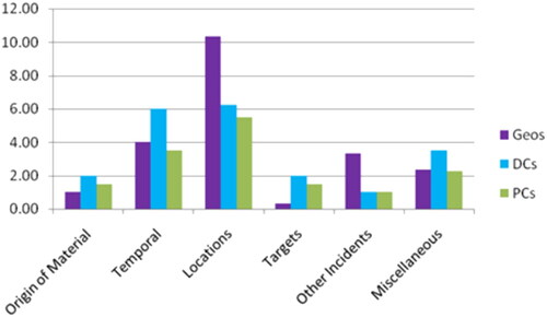
As can be seen in , the DC group produced the most considerations in the Origin of Material, Temporal, Targets and Miscellaneous themes, whilst the geos dominated the Locations and Other Incidents themes.
Qualitative analysis
Examining the considerations made in more detail, some investigative aspects are more prominent in the geos’ responses and others in the police officers’ responses. Below is a selection of considerations made, categorised into the same themes as the quantitative data.
Origin of material
The police officers voiced eight considerations with regards to whether the offender deliberately brought the items to be burnt to the scene or whether s/he just happened to find them (e.g., ‘…are there public bins nearby where you could get things from?’, or ‘items could have been collected en route to scene of crime’) whilst the geos voiced none on this particular topic. Identifying this might enable the investigation to glean the level of premeditation of the offence and a partial route taken by the offender if items were picked up from other locations.
Temporal
On the other hand, the geos spent time considering the relationship between timings and locations (e.g., ‘Plot offences against times, days & dates; see if there is any form or pattern’). Four such related considerations were made by the geos, compared to two mentions by the police officers. As many actions, even criminal ones, are down to rational choice processes, it follows that there is reasoning behind why perpetrators commit offences at certain locations and at certain times, the analysis of which could prove highly useful in an investigation.
Locations
All geos placed great importance on a personal scene visit, making statements such as ‘Visit the scene to gain understanding of demographics’, in order to identify potential routes travelled by the offender, access and exit options, the nature of the locations (social daytime, social night time, commuter, residential, etc.), and anything else that could be learned from the crime scene. All geos noted that they would conduct a scene visit. Of the police groups, only two probationers stated they would do so, of whom one said they would want to do that in order to see if they could establish a link between the addresses, and another stated they would look into victims’ rubbish bins (presumably external) to see where some of the material burnt and put through the letterboxes came from and what it was, and to establish how far away from each other the locations are. They did not appear to consider the nature of the locations nor the routes, whereas the geos did.
On the other hand, the officers made five considerations concerning which mode of transport the offender might have used, compared to zero from the geos (e.g., ‘Person might not drive, close locations’). Identifying how the perpetrator moved around can help determine how far away they came from, how well they might have known the area and perhaps if they triggered automatic number plate recognition (ANPR) cameras.
A point which was considered by all geos but none of the two other groups’ participants was the movement of the offender, the victim and witnesses before or after the offence (e.g., ‘Movements of offenders sighted leaving the scene or prior?’). These can be very significant, as where the offender came from could be highly informative and furthermore, the offender’s direction of travel following an offence can be indicative of their home location (Büchler & Leineweber, Citation1991; Rossmo, Citation2000).
Targets
Two of the comments made by detectives with regards to the offender’s choice of targets are noteworthy, and will be highlighted in the Discussion section below. These are that if the offender was not targeting particular victims but ‘just chooses a house as they’re walking past it [this] makes our job a lot harder’ and, in relation to the targets affected: ‘…if completely random that’s a complication’.
Other incidents
There was also a difference in the consideration of pre-cursor offences, which are forerunner offences carried out by the same perpetrator, often of lesser severity, which might not necessarily have been reported to police. Intelligence reports and witnesses to those precursors might provide valuable information and could potentially allow for a wealth of additional intelligence to be gathered as witnesses might know more about such incidents than about the main offence under investigation. Another advantage of identifying precursor offences is the fact that in being able to add precursor offences to the crime in question provides a richer sequence of events with more locations and timings to be included in the analysis, potentially making any inferences stronger. Therefore, the information and intelligence of precursor offences that can be linked to later crimes can provide an indication of where the offender was travelling from and possibly where s/he might live. The three geos considered precursor offences on five separate occasions (e.g., ‘…incidents/offences that took place before the 1st offence…’) whilst the eight police officers considered them only twice.
Miscellaneous
There was an error in the information provided in the case material of the arson series, as one day of the week was given wrongly in the table listing the offences. This means that it was not clear from the materials provided exactly how many days lay between that particular offence and the ones before and after it. This was not an intentional aspect of the study, but rather was down to how the case was received by the researcher. This offered up an interesting opportunity to observe how many of the participants noticed this inaccuracy when working through the case simulation documents. It transpired that all geos noticed and commented on the error in the information provided (e.g., ‘…but offence 2 has a mistake in the data’) and on the need to get this rectified before any meaningful analysis could be done, whilst none of the participants across the two police groups noticed this error. Not spotting such errors could have potential implications on the analysis of the timeline and other aspects of the rest of the investigation.
Conversely, the geos did not voice considerations regarding the possibility of there being more than one offender, whilst the officers did so five times (e.g., ‘one offender or group going round together’). PCs and DCs also made four mentions of potential mental health issues, compared to none made by the geoprofilers: ‘In my experience with arsons, high percentage people with mental health problems, learning difficulties’.
Discussion
The focus of this pilot study was to establish the existing level of geographic and temporal reasoning capabilities in an investigative context within police officers who have not had training on geographic profiling. The aim of this research was not to ascertain which group of participants would help solve a case, as the accuracy of considerations was not of interest here and was not ascertained. Therefore, participants’ output was not evaluated based on whether it would have benefited the investigation or not, but instead it was based on their considerations of geographic and temporal principles and the quantity and quality of these considerations. Quantitatively, the DC and geo groups were almost identical in terms of how many investigative considerations they made in relation to geographic and temporal aspects of a crime. This suggests that, given that the probationer group produced around 25% fewer considerations, geographic and temporal decision-making in an investigative context can clearly already be applied by experienced detectives to a certain extent.
Indeed, one of the most basic applications of geographic profiling, predicting the home location of a serial offender, has been shown to be performed by police officers informed of general spatial patterns of offending behaviour as accurately as computer geographic profiling systems (Bennell et al., Citation2007). This suggests that some quantitative aspects of GP can possibly be applied by the police quite easily, either with some basic training, or as was suggested by this research, even without it. Examining the data from a qualitative and content-based perspective however, a different pattern emerges.
Considering the comments made during the interviews, there does appear to be a gap in the level of understanding of the importance of geographic considerations: One detective noted that if the offender was not targeting a particular victim but ‘just chooses a house as they’re walking past it [this] makes our job a lot harder’, which suggests a lack of awareness of routine activities and the rich investigative opportunities that a spontaneous crime such as this provides. This is because there will usually be a connection between the location or route and the offender (i.e., a reason for the offender being on that route). The same could be said about a similar comment made by another DC: ‘…or if completely random that’s a complication’. In actual fact, if an offender did spontaneously decide to offend as s/he was walking past the victim’s house, that provides rich investigative leads as s/he was there for another reason (e.g., on her/his way home from work or a social engagement, going shopping, going to work or to an appointment) and it may well not have been the first nor the last time that s/he passed through that location.
Furthermore, practicalities need to be considered in order for advice to be deemed feasible: One police officer suggested using a helicopter, and another wondered if an officer could sit in a local fast food shop and watch if anyone retains the packaging after consuming food, which are both extremely resource-intensive strategies as well as potentially counter-productive - with that amount of visible surveillance, it is unlikely an offender could be caught in the act. At first glance, there appears to be no clear-cut difference between the areas or themes that the geos considered but not the police officers, or vice versa. However, there do appear to be some nuanced dissimilarities. Aspects that the geographic profilers paid attention to but not the police officers (spotting an error in the data, visiting the scene, including precursor offences, analysing offender and others’ movements, as well as analysing the relationship between timings and locations) are very deep-rooted in geographic profiling (Knabe-Nicol & Alison, Citation2011). These are elementary aspects of a geographic/temporal analysis, yet not necessarily aspects of every-day policing. Therefore, it is not surprising that they are less at the forefront of the officers’ minds. Conversely, although the aspects that the police considered but not the geographic profilers (items brought to the scene or found nearby, mode of transport, one offender or more, and mental health issues of the offender’s) also carry weight in terms of having great potential for spatial and temporal analysis, they perhaps are already more integrated into routine investigative processes. One could argue that the two approaches therefore complement each other somewhat and offer a more rounded investigative approach to this arson series when combined. In fact, some investigative areas do overlap.
One study found that experienced car crime investigators were no better at linking car crimes than were investigators experienced in other areas (Santtila et al., Citation2004). That research further identified that those who correctly linked the right crimes (in either participant group) had paid more attention to locations and timings of the offences as well as considering the possibility of chained takings (stealing several cars in the same night, possibly in a directional and/or linear pattern), which are considerations that are fundamental in GP. The fact that 37% of police officers in this pilot study stated they had heard of GP before does not imply that they understand it or even utilise it in any way. Even though the sample size of this pilot study was very small, it suggests that at least to some extent, whilst a number of GP considerations are already inherent in investigations, some of the rich capabilities this technique offers are going unrecognised and unused within the police. Interestingly, whilst the geos did not mention any of the considerations with regards to where source materials might come from, the offender’s mental health or mode of transport in this particular case simulation, the preceding two stages of ACTA performed in the original data collection with the geos have shown that these considerations do form part of the fundamental deliberations a geo works through when analysing an offence (Knabe-Nicol & Alison, Citation2011). It is not known why they did not mention them again during the case simulation. It is possible that they felt it had already been mentioned during the previous two ACTA stages and they therefore did not feel it was necessary to repeat it during the simulation interview stage.
Future directions & limitations
The sample sizes of the participant groups for this pilot study were very small, as they included a highly specialised group of experts. It is recommended that this study be replicated with a much larger sample size of police officers of varying levels of experience in order to further test the current findings. Any research that is carried out on a highly specialised team of experts is necessarily going to be faced with small sample sizes. On the other hand, the simulation case was carried out using 75% of the geoprofilers in the UK at the time, and even though the actual number may be small as a sample size, this research is very highly representative of the sample in question.
The research was carried out in the time leading up to a previous publication in 2011. It is unknown whether the processes employed at the time still reflect current GP practice. Whilst the four geos at the time were since reduced to one, there are many police analysts trained in geographic profiling, making them the bulk of GP practitioners. Their views and some of their procedures have been described in recent more literature (e.g. Emeno et al., Citation2016); Marsden and Taylor (Citation2022) and Öhrn (Citation2019).
Further studies could therefore include police analysts as a separate participant group, as they have specialist training in analysing patterns of offending, to see if they use geographic profiling principles any differently to how police officers and geos do. Targeted inputs to police officers could be developed and delivered, after which the investigative processes and outcomes of the delegates of those inputs could be compared to equivalent officers’ work who have not received the training, in order to gauge any value added by the input.
A cognitive task analysis such as the one utilised for this research will always be dependent on participants actually verbalising all their thought processes. If one of them has a specific thought but finds it irrelevant, this thought or topic will then appear not to have been present at all, potentially leading the researcher to falsely conclude that this was not considered by the participant, when the latter had simply failed to articulate it. Therefore, whilst some things the researcher will note as not having featured in the participant’s thought process will in fact not have been considered, other thoughts might have occurred to the individual but may simply not have been mentioned. This might of course skew the resulting analysis somewhat.
On the other hand, participants might have ‘over-performed’ as they were in a situation where a researcher was listening closely and writing down what they were saying and this might have led some to put more effort into their thought processes than they would do in their day-to-day job. Even though the police participants were by their own admission not familiar with geographic profiling, they were aware from the participant information sheet and the title of the consent form that this research was in relation to geographic profiling. It is therefore conceivable that they made specific efforts to focus their thoughts on geographic aspects in order to perform well at this task, being fully aware they were under scrutiny. It is not known if they would perform to the same level as part of their routine occupation if no-one was sitting in front of them writing down their almost every word after having introduced the research as a study on geographic profiling.
Conclusion
This research suggests that a number of geographic profiling principles are already being applied in some measure within the police. However, some of the fundamental yet in-depth processes of geographic profilers, such as the very careful analysis of timings and locations, their relation to each other, then tying that in with offender and victim movements, analysing the scene in detail and including precursor offences etc., were lacking among the police sample in this research. It could therefore be surmised that targeted inputs conveying more understanding of geographic profiling might support the police in developing these skills further in order to use them more effectively and not miss out on investigative opportunities. Furthermore, it might be worthwhile, at least for initial research purposes, for someone with a very sound knowledge of geographic profiling to review some unsolved police cases in order to assess the level of geographic & temporal analyses that could have been conducted and if they would have provided any further lines of enquiry. If that initiative finds that some of these cases should be re-opened, then we know there is further work to be done, and those cold-case reviews from a GP perspective should be rolled out further. It might even be advisable to have a GP-trained individual in every force to assist in the large number of cases for which the NCA-employed geoprofiler is not consulted. That individual is available to all UK police forces for the most complex and serious crimes which warrant his input. However, all the other cases currently have no support from a geographic and temporal perspective, and until a review or appropriate research project such as the one suggested above is put in place, it is not known how many investigative opportunities have been missed because of that. It is the conclusion of this study, however, that as a number of GP principles are already inherent within police investigations, yet others are not, that equipping detectives with basic to advanced knowledge of GP may greatly enhance investigative capabilities of the police in the UK. Furthermore, in the many cases which never cross the NCA geoprofiler’s desk, upskilling active police personnel could potentially help solve a number of crimes that would have previously remained unsolved.
Disclosure statement
No potential conflict of interest was reported by the author(s).
Additional information
Notes on contributors
Susanne Knabe-Nicol
Susanne Knabe-Nicol is program leader for the BA Criminology with Policing & Investigations at Middlesex University, London. She teaches policing, investigations, investigative psychology and criminology there. Before that, she was Director of Communications at the Cambridge Centre for Evidence-Based Policing and prior to that she worked for Suffolk & Norfolk Constabularies in a number of civilian roles, including investigator. She set up www.PoliceScienceDr.com, with the mission to make research findings more accessible to law enforcement. Susanne has a BSc in Psychology, an MSc in Interactive Multimedia, and an MSc and PhD in Investigative Psychology.
Laurence Alison
Laurence Alison MBE has an international track record of publishing on the subject of high stakes decision making, investigative profiling and investigative interviewing. He is Chair in Forensic and Investigative Psychology at the University of Liverpool. PhD Forensic & Investigative Psychology, 1998 (University of Liverpool). MSc Forensic & Investigative Psychology (Distinction), 1994 (University of Surrey). BSc Psychology (Distinction), 1993 (University College London).
References
- Amir, A. (1971). Patterns in forcible rape. Chicago University of Chicago Press.
- Aygin, D. T., Cox, L. A., Faulkner, S. C., Stevens, M. C. A., Verity, R., & Le Comber, S. C. (2021). Double cross: Geographic profiling of V-2 impact sites. Journal of Spatial Science, 66(2), 1–14. https://doi.org/10.1080/14498596.2019.1642249
- Baber, C. (2010). Distributed cognition at the crime scene. AI & Society, 25(4), 423–432. https://doi.org/10.1007/s00146-010-0274-6
- Baber, C., & Butler, M. (2012). Expertise in crime scene examination: Comparing search strategies of expert and novice crime scene examiners in simulated crime scenes. Human Factors, 54(3)June 2012, 413–424. https://doi.org/10.1177/0018720812440577
- Bennell, C., Snook, B., Taylor, P. J., Corey, S., & Keyton, J. (2007). It’s no riddle, choose the middle: The effect of number of crimes and topographical detail on police officer predictions of serial burglars’ home locations. Criminal Justice and Behavior, 34(1), 119–132. https://doi.org/10.1177/0093854806290161
- Berezowski, V., MacGregor, D., Ellis, J., Moffat, I., & Mallett, X. (2023). More than an offender location tool: Geographic profiling and body deposition sites. Journal of Police and Criminal Psychology, 38, 3–19.
- Brantingham, P. J., & Brantingham, P. L. (1981). Environmental criminology. Sage Publications.
- Brantingham, P. J., & Brantingham, P. L. (1984). Patterns in crime. MacMillan.
- Brantingham, P. L., & Brantingham, P. J. (1991). Notes on the geometry of crime. In P. J. Brantingham & P. L. Brantingham (Eds.), Environmental criminology (2nd ed., pp. 27–54). Waveland Press.
- Brantingham, P. L., & Brantingham, P. J. (1993). Environment, routine, and situation: Toward a pattern theory of crime. In R. V. Clarke & M. Felson (Eds.), Routine activity and rational choice (pp. 259–294). Transaction Publishers.
- Brantingham, P. J., & Brantingham, P. L. (2008). Crime pattern theory. In R. Wortley & L. Mazerolle (Eds.), Environmental criminology and crime analysis (pp. 78–93). Willan Publishing.
- Büchler, H., & Leineweber, H. (1991). The escape behaviour of bank robbers and circular blockade operations by the police. In E. Kube & H. U. Störzer (Eds.) Police research in the Federal Republic of Germany: 15 years research within the Bundeskriminalamt (pp. 199–208). Springer – Verlag.
- Canter, D. V., Coffey, T., Huntley, M., & Missen, C. (2000). Predicting serial killers’ home base using a decision support system. Journal of Quantitative Criminology, 16(4), 457–478. https://doi.org/10.1023/A:1007551316253
- Canter, D. V., & Gregory, A. (1994). Identifying the residential location of rapists. Journal - Forensic Science Society, 34(3), 169–175. https://doi.org/10.1016/s0015-7368(94)72910-8
- Canter, D. V., & Larkin, P. (1993). The environmental range of serial rapists. Journal of Environmental Psychology, 13(1), 63–69. https://doi.org/10.1016/S0272-4944(05)80215-4
- Chainey, S., & Ratcliffe, J. H. (2005). GIS and crime mapping. Wiley.
- Cohen, L. E., & Felson, M. (1979). Social change and crime rate trends: A routine activity approach. American Sociological Review, 44(4), 588–608. https://doi.org/10.2307/2094589
- Cornish, D. B. (1993). Theories of action in criminology: Learning theory and rational choice approaches. In R. V. Clarke & M. Felson (Eds.), Routine activity and rational choice (pp. 351–382).
- Curtis-Ham, S., Bernasco, W., Medvedev, O. N., & Polaschek, D. L. L. (2020). A framework for estimating crime location choice based on awareness space. Crime Science, 9(1), 1. https://doi.org/10.1186/s40163-020-00132-7
- Curtis-Ham, S., Bernasco, W., Medvedev, O. N., & Polaschek, D. L. L. (2022). A new geographic profiling suspect mapping and ranking technique for crime investigations: GP-SMART. Journal of Investigative Psychology and Offender Profiling, 19(3), 103–117. https://doi.org/10.1002/jip.1585
- Daniell, C. (2008). Geographic profiling in an operational setting: The challenges and practical considerations, with reference to a series of sexual assaults in Bath, England. In Chainey, S. & Tompson, L. (Eds.), Crime mapping case studies: Practice and research. John Wiley & Sons.
- Davies, A., & Dale, A. (1995). Locating the stranger rapist (Special Interest Series: Paper 3). Police Research Group, Home Office Police Department.
- Doney, R. H. (1990). The aftermath of the Yorkshire Ripper: The response of the United Kingdom police service. In Egger, S. (Ed.), Serial murder: An elusive phenomenon (pp. 95–112). Praeger Publishing.
- Emeno, K., Bennell, C., Snook, B., & Taylor, P. J. (2016). Geographic profiling survey: A preliminary examination of geographic profilers’ views and experiences. International Journal of Police Science & Management, 18(1), 3–12. https://doi.org/10.1177/1461355715621070
- Fleiss, J. L. (1981). Statistical methods for rates and proportions. (2nd ed.). Wiley.
- Godwin, M. (1996). Mapping human predators: The geographical behaviour of fifty-four American serial killers. Retrieved from http://www.geocomputation.org/1996/abs040.htm
- Górski, M. (2022). Geographic profiling and event prediction for seventeenth- and eighteenth-century pirates. The Professional Geographer, 74(4), 781–791. https://doi.org/10.1080/00330124.2022.2075405
- Herrnstein, R. J. (1990). Rational choice theory – necessary but not sufficient. American Psychologist, 45(3), 356–367. https://doi.org/10.1037/0003-066X.45.3.356
- Hirama, K., Yokota, K., Otsuka, Y., Watanabe, K., Yabe, N., Yokota, R., & Hawai, Y. (2023). Geographical profiling incorporating neighbourhood-level factors using spatial interaction modelling. Journal of Investigative Psychology and Offender Profiling, 20(2), 135–150. https://doi.org/10.1002/jip.1611
- Kind, S. (1987). Navigational ideas and the Yorkshire ripper investigation. Journal of Navigation, 40(3), 385–393. https://doi.org/10.1017/S0373463300000631
- Knabe, S. (2008). Geographic Profiling under the microscope – a critical examination of the utility of Geographic Profiling and expert Geographic Profilers University of Liverpool. (Unpublished MSc Dissertation)
- Knabe-Nicol, S., & Alison, L. (2011). The cognitive expertise of geographic profilers. In L. Alison & L. Rainbow (Eds.), Professionalising offender profiling: Forensic and investigative psychology in practice (pp. 126–159). Routledge.
- Kocsis, R. N., & Irwin, H. J. (1997). An analysis of spatial patterns in serial rape, arson, and burglary: the utility of the circle theory of environmental range for psychological profiling. Psychiatry, Psychology and Law, 4(2), 195–206. https://doi.org/10.1080/13218719709524910
- Levine, N. (2000). CrimeStat: A spatial statistics program for the analysis of crime incident locations (Version 1.1). National Institute of Justice.
- Marsden, A., & Taylor, M. (2022). The development of a new capability: Geographic Profiling Analysis in Australia. In M. Bland, B. Ariel, & N. Ridgeon (Eds.), The crime analyst’s companion (pp. 125–139). Springer International Publishing.
- McRobert, A. P., Williams, A. M., Ward, P., & Eccles, D. W. (2009). Tracing the process of expertise in a simulated anticipation task. Ergonomics, 52(4), 474–483. https://doi.org/10.1080/00140130802707824
- Meaney, R. (2004). Commuters and marauders: An examination of the spatial behavior of serial criminals. Journal of Investigative Psychology and Offender Profiling, 1(2), 121–137. https://doi.org/10.1002/jip.12
- Mburu, L., & Helbich, M. (2015). Evaluating the accuracy and effectiveness of criminal geographic profiling methods: The case of Dandora, Kenya. The Professional Geographer, 67(1), 110–120. https://doi.org/10.1080/00330124.2014.886921
- Militello, L. G., Hutton, R. J. B., Pliske, R. M., Knight, B. J., & Klein, G. (1997). Applied Cognitive Task Analysis (ACTA) Methodology. (Rep. No. NPRDCTN-98-4). Navy Personnel Research and Development Center.
- Öhrn, M. (2019). [We look at crime through the lens of geographic behaviour: Geographic profiling in operational settings]. [Masters thesis]. University of Gothenburg. ]. https://gupea.ub.gu.se/handle/2077/59807
- Perry, W. C., McInnis, B., Price, C. C., Smith, S. C., & Hollywood, J. S. (2012). Using predictions to support police operations. In Predictive policing: The role of crime forecasting in law enforcement operations (p. 67). RAND.
- Raab, M., & Johnson, J. G. (2007). Expertise-based differences in search and option-generation strategies. Journal of Experimental Psychology. Applied, 13(3), 158–170. https://doi.org/10.1037/1076-898X.13.3.158
- Reber, A. S. (1985). The penguin dictionary of psychology. Penguin.
- Rhodes, W. M., & Conly, C. (1981). Crime and mobility: An empirical study. In P. J. Brantingham, & P. L. Brantingham (Eds.), Environmental criminology (pp. 167–188). Sage.
- Rossmo, D. K. (1995). Place, space, and police investigations: Hunting serial violent criminals. Crime Prevention Studies, 4, 222.
- Rossmo, D. K. (2000). Geographic profiling. CRC Press.
- Santtila, P., Korpela, S., & Häkkänen, H. (2004). Expertise & decision-making in the linking of car crime series. Psychology, Crime & Law, 10(2), 97–112. https://doi.org/10.1080/1068316021000030559
- Schraagen, J. M., & Leijenhorst, H. (2001). Searching for evidence: Knowledge and search strategies used by forensic scientists. In E. Salas & G. Klein (Eds.), Linking expertise and naturalistic decision making (pp. 263–274). Lawrence Erlbaum.
- Snook, B., Canter, D. V., & Bennell, C. (2002). Predicting the home location of serial offenders: A preliminary comparison of the accuracy of human judges with a geographic profiling system. Behavioral Sciences & the Law, 20(1–2), 109–118. https://doi.org/10.1002/bsl.474
- Snook, B., Taylor, P. J., & Bennell, C. (2004). Geographic profiling: The fast, frugal and accurate way. Applied Cognitive Psychology, 18(1), 105–121. https://doi.org/10.1002/acp.956
- Snow, J. (1855). On the mode of communication of cholera.
- Stevens, M. C. A., Ray, G., Faulkner, S. C., & Le Comber, S. C. (2020). Investigating Sherlock Holmes: Using geographic profiling to analyze the novels of Arthur Conan Doyle. The Professional Geographer, 72(4), 566–574. https://doi.org/10.1080/00330124.2020.1758575
- Stevenson, M. D., Rossmo, D. K., Knell, R. J., & Le Comber, S. C. (2012). Geographic profiling as a novel spatial tool for targeting the control of invasive species. Ecography, 35(8), 704–715. https://doi.org/10.1111/j.1600-0587.2011.07292.x
- Tamura, M., & Suzuki, M. (1997). Criminal profiling research on serial arson. 1. Examination of circle hypothesis estimating offender’s residential area. Reports of the National Research Institute of Police Science, Research on Prevention of Crime and Delinquency, 38, 13–25.
- Tuthill, K. (2003). John Snow and the Broad Street Pump. On the Trail of an Epidemic. Available from http://www.ph.ucla.edu/epi/snow/snowcricketarticle.html;
- Wang, M., Ni, B., Hua, X.-S., & Chua, T.-S. (2012). Assistive tagging: A survey of multimedia tagging with human-computer joint exploration. ACM Computing Surveys, 44(4), 1–24. https://doi.org/10.1145/2333112.2333120
- Warren, J. I., Reboussin, R., & Hazelwood, R. R. (1995). The geographic and temporal sequencing of serial rape. U.S. Government Printing Office.