
Abstract
The natural behaviour of the earth’s surface is proceeding through morphometric analyses and its environmental aspects. Different aspects of morphometric analyses depends upon geological transformation of earth surface. The structure of landscape determines the river flow from upper to lower elevation. The morphometric studies of river integrates the new geo morphological features with the climatic factors such as rainfall, temperature, atmospheric pressure and wind. The drainage map is prepared using the toposheets, delineating the streams and watershed boundary. The strahler method classifies the stream orders for this sophisticated morphometric analyses. The quantitative morphometric analysis carried out in Neyyar sub-watershed includes Network analysis; Basin geometry; Texture analysis and Relief characteristics. The relief characteristics were used to generate the hypsometric curve which exhibit the monadnock and reliefs of coastal morphology. Drainage, Drainage Density, Geomorphology, Landuse/Landcover, and Slope were prepared using Geographic Information Systems (GIS). The present study concludes the influence of the parameters and thematic data in understanding the geomorphological problems and stating a sustainable development of water resources in Neyyar sub-watershed.
1. Introduction
Natural disasters like landslide, earthquake, flood, drought and cyclone are threatening mankind and causes loss of life and property damage. Such hazards have grown over the years due to the rapid growth of population and physical resources. The study of natural hazards and their effects happened to be one of the most dynamic areas of morphology. Morphological studies include the quantitative analysis of landform shapes and the processes modifying those landforms. Traditionally, morphological approaches focuses on field observation, survey and laboratory test. Remote sensing (RS), computer-assisted mapping, and Geographic Information Systems (GIS) have advanced rapidly since 1970. In addition, the high-resolution satellite imagery, ground-based monitoring and computer based topographic models are now readily available at free or low cost. Hence, the RS and GIS based morphological approaches have considerable advantages over traditional geomorphological study.
In the present study, morphometric analyses of the Neyyar River Basin, Southern Kerala, India is examined using a drainage map, topography models and satellite imagery. The Neyyar River Basin area consists a number of dynamic, interrelated physical, social and economic factors (Suresh Babu & Thrivikramaji, Citation1993). The Thiruvananthapuram city is built on seven hills by the sea shore and is located (8° 5′ N and 76° 9′ E) on the west coast, near the southern tip of mainland India. The city spans an area of 214.86 km2 and is bounded by the Arabian Sea to its west and the Western Ghats to its east. The State of Kerala is blessed with 44 rivers, numerous lakes, ponds, estuaries and backwater systems. Hence, in the present day, an attempt has been made to analyse the basic aspects of the Neyyar sub-watershed in Thiruvananthapuram district, Southern Kerala. Eighty five quantitative analyses parameters were carried out thoroughly by Pareta and Pareta (Citation2011a; Citation2011b) in the Yamuna basin and Karwan watershed, respectively on considering the geology, geomorphology, physiography, landuse/landcover and lineaments for groundwater exploitation. Satellite remote sensing has an ability of obtaining the synoptic view of a large area at one time, which is very useful in analysing the drainage morphometry. GIS has proved to be an efficient tool in drainage delineation (Kulkarni, Davalbhakt, & Waikar, Citation2014; Rekha, George, & Rita, Citation2011). The application of RS and GIS for the analysis of morphometric parameters is found to be of immense utility in watershed prioritization for soil, water conservation and natural resources management (Ali & Ali, Citation2014; Khare, Mondal, Mishra, Kundu, & Meena, Citation2014).
2. Study area
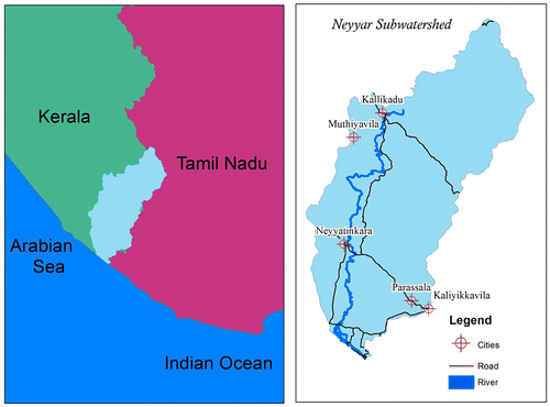
The Neyyar River is one among the 44 west flowing streams of Kerala (Figure ). It runs for a length of 56 km and is the southernmost river of the State. The sub-watershed lies between 8° 17′2″ N to 8° 53′2″ N latitude and 76° 40′2″ E to 70° 17′2″ E longitude. The total drainage area of the sub-watershed is 497 km2. The Neyyar River basin spread over 18 panchayats of the Thiruvananthapuram district originates from the Agasthya mala at an elevation of about 1860 m above mean sea level (MSL). It then flows rapidly following the steep terrain and reaches the flat plains. It flows down in a southwesterly direction in the mountainous region and then takes a westerly course up to Ottasekharamangalam where it again turns west and from Valappallikonam traces a southwesterly course till it empties into the Arabian Sea. The general elevation ranges from 1500 m in the upper region, 200 m in the middle region and therfore less than 2 m in the lower region. The broad landforms include medium hills and isolated hill rocks in the upper region, lateritic mounds and uplands at the lower region of the watershed. The larger part of the Neyyar sub-watershed is composed of crystalline rocks like Charnokite, Gneisses of different categories, and their altered products (Suresh Babu & Thrivikramaji, Citation1993).
Figure 1. General keymap of Neyyar sub-watershed tells about the location and its pathway of roads, Neyyar river, and settlements.
3. Methodology
The study is effectively done using modern RS and GIS techniques. The map of the Neyyar sub-watershed drainage was prepared with the help of Survey of India (SOI) toposheets and then it was digitized. SOI toposheets, 58H/2, H/3, and H/6 on the scale of 1:50,000 were used for the present study. From the streams, it is easy to extract the stream order following the Strahler method. Further, the cited formula is used to implement the morphometric analyses as shown in the following tables , and . The methodology includes the various aspects of the morphometric condition over the sub-watershed and it derived the basic characteristics of the sub-watershed such as aerial, linear and relief. The derived formula was further proposed to eradicate detailed morphometric study with the statistical methods and mathematical calculation using GIS software from the various authors. Aster-GDEM (describes the relief characters based upon slope percentage) and Landsat 8 (False colour combination to interpret geomorphology) were used to prepare various thematic maps in GIS. Drainage is ditized from the toposheets of the study area and the density is calculated by grid-based 1 km2 of stream length. This also classifies first-level National Remote Sensing Centre (NRSC) Landuse/Landcover using Supervised Classification.
4. Results and discussions
4.1. Morphometric analysis
The shape and dimensions of the landforms is measured by the mathematical approaches to describe the geomorphic conditions and hydrological processes and this type of landform is known as morphometry. The basic parameters for the investigation consist of area, altitude, volume, slope, profile, and texture of landforms. The GIS technique implements different morphometric parameters to link the drainage morphometry, properties of landforms, soils and eroded lands (Pareta & Pareta, Citation2012). The morphometric characteristics of different sub-watersheds show their relative characteristics with respect to the hydrologic response of the watershed (Ali & Ali, Citation2014). Yunus, Oguchi, and Hayakawa (Citation2014) achieved twenty one morphometric parameters for 36 sub-basins where it had interpreted the fluvial and hillslope erosion using Principal Component Analysis and its scores. Morphometric analyses of the Neyyar sub-watershed are chiefly based on the GIS technique and its statistical methods. Morphometric analyses are broadly classified on the basis of three aspects ‘linear’, ‘aerial’ and ‘relief’ (da Cunha & Bacani, Citation2016; Deepak, Arun, Prabash, Sananda, & Pramod, Citation2014; Rekha et al., Citation2011). But, this study is implemented on four aspects ‘Network analysis’, ‘Basin geometry’, ‘Texture analysis’ and ‘Relief characteristics’.
4.1.1 Network analysis
In this drainage network analysis, number of morphometric characters behaves in a linear aspects way; they are Stream Order (Su); Stream Number (Nu); Bifurcation Ratio (Rb); Weighted Mean Bifurcation Ratio (Rbwm) and these were calculated using GIS statistical methods (Table ). The Stream Length (Lu); Mean Stream Length (Lum); Stream Length Ratio (Lurm) are calculated and tabulated (Table ). The Length of Main Channel (Cl); Channel Index (Ci), Valley Index (Vi) and Rho Coefficient (ρ) are also estimated (Table ).
Table 1. Stream order, streams number, and bifurcation ratios in Neyyar sub-watershed.
Table 2. Stream length and stream length ratio in Neyyar sub-watershed.
Table 3. Formulas, reference, and result of drainage network in Neyyar sub-watershed.
4.1.2. Basin geometry
The basin geometry is recognised by morphometric condition in a watershed area/perimeter and it is coined as aerial aspects. Stream order wise mean area (Am), Area ratio (Ar), Mean area ratio (Arm) and Weighted mean area ratio (Arwm), were described based on the areal coverage of the stream (Table ). Basin geometry comprises of Length of the basin (Lb); Basin area (A); Basin Perimeter (P); Length Area Relation (Lar); Lemniscate’s (k); Form Factor (Ff); Elongation Ratio (Re); Texture Ratio (Rt); Circularity Ratio (Rc); Drainage Texture (Dt); Compactness Coefficient (Cc); Fitness Ratio (Rf); Wandering Ratio (Rw); Watershed Eccentricity (τ); Centre of Gravity of the Watershed (Gc) and Sinuosity Index (Si) were calculated using formulae mentioned in Table .
Table 4. Stream order, stream order wise mean area in Neyyar sub-watershed.
Table 5. Formulas, reference, and result of basin geometry in Neyyar sub-watershed.
4.1.3. Drainage texture analysis
Land surface pattern and its specific nature is categorized through the texture analysis for better understanding of the Neyyar sub-watershed. It mostly deals with the characters of geomorphic condition as hard or smooth terrain. It is also combined with both linear and aerial aspects. This analysis results in delineating the morphometric parameters of Drainage Density (DD); Constant of Channel Maintenance (1/Dd); Drainage Intensity (DI); Infiltration Number (If); Drainage Pattern (Dp) and Length of Overland Flow (Lg) in Table .
Table 6. Formulas, reference, and result of drainage texture analysis in Neyyar sub-watershed.
4.1.4. Relief characteristics
The Aster G-DEM denotes the elevation which is generally used for slope aspect and its terminology. The hypsometric curve identifies three types of landforms namely young, mature and monadnock (Strahler, Citation1956) observed in hypsometric integral. Thus, it varies in altitude and area within the Neyyar sub-watershed (Table ) which together executes the hypsometric curve (Figure ).
Table 7. Different stages of hypsometric estimation.
Figure 2. Hypsometric curve defines the relief characteristics to determine the soil erosion.
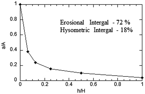
The hypsometric curve explains the rejuvenation through the tectonic activities (Farhan, Anbar, Enaba, & Al-Shaikh, Citation2015). From the Digital Elevation Model (DEM) we have calculated the morphometric parameters such as Relief Ratio (Rhl); Relative Relief (Rhp); Absolute Relief (Ra); Channel Gradient (Cg); Ruggedness Number (Rn); Melton Ruggedness Number (MRn); Dissection Index (Dis); Gradient Ratio (Rg); Gradient and Channel; Slope (Sgc); Slope Analysis (Sa); Average Slope of the Watershed (S); Hypsometric Analysis (Hs); Clinographic Analysis (Cga); Erosion Surface (Es); Longitudinal Profiles (Lp) and Concavity Index (Ca) which are derived in detail at (Table ).
Table 8. Formulas, reference, and result of relief characteristics in Neyyar sub-watershed.
Morphometric analyses were formulated by several authors in the past decades using RS and GIS. The simplest way is to collect the information in a systematic manner and to calculate the area, length, volume, depth, height, etc. observed by GIS. The DEM is a useful tool for developing the hydrological routing parameter for hydrological studies. Relief character is usually tough to obtain as spatial elevation of an area.
4.2. Thematic maps
The GIS helps to prepare the thematic maps to recognize the various characters of land morphology conditions. Similarly, DEM, drainage, drainage density, geomorphology, landuse/landcover and slope organized to manage the water resources naturally. Several thematic behaviours explain the whole part of Neyyar sub-watershed and thereby it defines the shape and dimension of sub-wateshed and it causes a river flow movement from high to low relief due to gravitational pull.
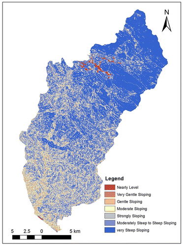
DEM represent the basic topography of landscape features which describes the North side of Neyyar sub-watershed shows higher relief about 1500 m and thereby south side of Neyyar sub-watershed show the low relief about 2 m (Figure ). The study region has seven stream orders where most of the first and second stream orders are coarse occupied at the top of Neyyar sub-watershed and it drains into the Neyyar reservoir (Figure ). Therefore, it is noticed and defined that the Neyyar drainage basin has dendritic pattern. Drainage density of Neyyar sub-watershed is denser at the northern part which decreases towards southern direction. It depends heavily upon the stream orders where it is coarser and finer and it gives the spatial resolution in volume of water (Figure ). The geomorphologic features are clearly examined and deliver that top portion of Neyyar sub-watershed occupied by the structural hill; which have the geology of Charnokite and Gneiss. Plateau moderately dissected is almost occupied and represents the moderately weathered region caused by the activity of water erosion. Rock exposure, residual mount and linear ridges are generally segregated from the structural hills. Coastal plain and beach is formed as part of coastal morphology (Figure ). Landuse/Landcover of this area is almost covered by scrubland which was 75% of Neyyar sub-watershed, 20% of forest area and remaining area of barren land, buildup land, and water bodies (Figure ). This is due to semi humid climate and it is fertile due to weathered deposit. Aster G-DEM of Neyyar watershed has used to seven classes using Integrated Mission for Sustainable Development method (Figure ). Very steep sloping takes place at forest area and coarse drainage pattern. Nearly level is aligned over the Neyyar reservoir. Alternate sloping is distributed randomly over the Neyyar sub-watershed.
Figure 3. Aster G-DEM of Neyyar sub-watershed gives the detailed topography which deals with the relief characteristics.
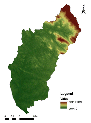
Figure 4. Neyyar sub-watershed holds up to seven stream orders classified through the Strahler method, determine the drainage network system.
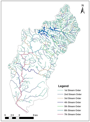
Figure 5. Drainage networks of Neyyar sub-watershed deals with the grid-based methods to understand the volume of water holding capacity.
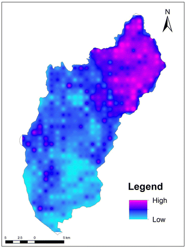
Figure 6. Geomorphology of Neyyar sub-watershed using Landsat imagery interprets the different morphology condition from the young to mature stage of River.
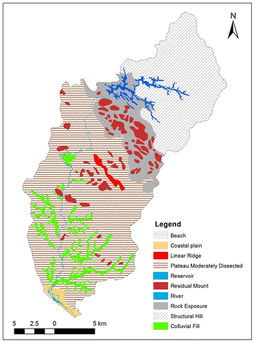
Figure 7. Landuse/landcover of Neyyar sub-watershed using Landsat imagery interprets the NRSC level 1 Classification, to understand the natural and artificial usage in the earth surface.
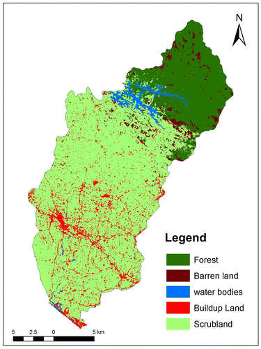
Figure 8. Slope of Neyyar sub-watershed using Aster-DEM classified through IMSD level, which deals with the nearly level to very steep sloping.
Neyyar sub-watershed has assigned its character and behaviour by the various thematic preparations reveals the defined planning for water resources development. It indicates as a direct way for obtaining the characteristics through climate morphology like rainfall, temperature, atmospheric pressure, wind wind etc. It also indirectly signifies the geological formation and its tectonic activities within the Neyyar sub-watershed.
5. Conclusion
The civilisation and urbanisation patterns have been stronger near river system. Urbanisation near river system affects its physical process and further changes the natural vegetation into various landuse patterns. In India, west flowing rivers almost receive high rainfall on their monsoon so it has high vegetation covered area. They have small watershed area and it experiences different morphology throughout the river. From this study, Neyyar sub-watershed starts from highly elevated area and ends in Arabian Sea. Quantitative morphometric analyses in Neyyar sub-watershed are briefly executed by measuring the shape and dimension of earth surface in mathematical approach with the help of GIS and RS and detail tabulation mentioned above. The various aspects of morphometric analyses are modified in this study to assemble more information about the different landform formed by the process of fluvial geomorphology. Over Neyyar sub-watershed it is observed that the regions with steep slope along with less vegetation cover contributes to high erosion and surface runoff. Thus, morphometric analysis shows the brief description about the causes and behavior of water resource formation due to geological landforms.
References
- Ali, U., & Ali, S. A. (2014). Analysis of drainage morphometry and watershed prioritization of Romushi-Sasar catchment, Kashmir valley, India using remote sensing and GIS technology. Journal of Advanced Research, 2, 5–23.
- Black, P. E. (1972). Hydrograph response to geometric model watershed characteristics and precipitation variables. Journal of Hydrology, 17, 309–329.10.1016/0022-1694(72)90090-X
- Broscoe, A. J. (1959). Quantitative analysis of longitudinal stream profiles of small watersheds ( Project N. 389-042, Tech. Bep. 18). New York, NY: Columbian University.
- Brown, E. H. (1952). The river Ystwyth, Cardiganshire: A geomorphological analysis. Proceedings of the Geologists' Association, 63, 244–269.
- Chorley, R. J. (1969). Introduction to fluvial processes. London: Methuen.
- da Cunha, E. R., & Bacani, V. M. (2016). Morphometric characterization of a watershed through SRTM data and geoprocessing technique. Journal of Geographic Information System, 8, 238.10.4236/jgis.2016.82021
- Deepak, K., Arun, M., Prabash, K. M., Sananda, K., & Pramod, K. M. (2014). Morphometric analysis for prioritization using remote sensing and GIS techniques in a hilly catchment in the state of Uttarakhand, India. Indian Journal of Science and Technology, 7, 50–62.
- Faniran, A. (1968). The index of drainage intensity – A provisional new drainage factor. Australian Journal of Science, 31, 328–330.
- Farhan, Y., Anbar, A., Enaba, O., & Al-Shaikh, N. (2015). Quantitative analysis of geomorphometric parameters of Wadi Kerak, Jordan, using remote sensing and GIS. Journal of Water Resource and Protection, 7, 456–475.10.4236/jwarp.2015.76037
- Gravelius, H. (1914). Grundrifi der gesamten gewcisserkunde, Band I: Flufikunde [Compendium of Hydrology, vol. I. Rivers, in German]. Berlin: Goschen.
- Hack, J. T. (1957). Studies of longitudinal stream profiles in Virginia and Maryland. U.S. Cool. Survey Prof. Paper 294- B, B45-897.
- Horton, R. E. (1932). Drainage-basin characteristics. Transactions, American Geophysical Union, 13, 350–361.10.1029/TR013i001p00350
- Horton, R. E. (1945). Erosional development of streams and their drainage basins. Geological Society of America Bulletin, 56, 275–370.10.1130/0016-7606(1945)56[275:EDOSAT]2.0.CO;2
- Khare, D., Mondal, A., Mishra, P. K., Kundu, S., & Meena, P. K. (2014). Morphometric analysis for prioritization using remote sensing and GIS techniques in a hilly catchment in the state of Uttarakhand, India. Indian Journal of Science and Technology, 7, 1650–1662.
- Kulkarni, U. D., Davalbhakt, H. A., & Waikar, M. L. (2014). Geomorphological analysis of tank catchment using geographical information system: A case STUDY. International Journal of Emerging Technology and Advanced Engineering, 4, 867–872.
- Melton, M. A. (1957). An analysis of the relations among elements of climate, surface properties and geomorphology ( Project NR 389042, Tech. Rep. 11). New York, NY: Columbia University.10.21236/AD0148373
- Melton, M. A. (1965). The geomorphic and paleoclimatic significance of alluvial deposits in Southern Arizona. The Journal of Geology, 73, 1–38.10.1086/627044
- Miller, V. C. (1953). A quantitative geomorphic study of drainage basin characteristics in the Clinch Mountain area, Virginia and Tennessee ( Of. Nav. Res. Proj. NR 389-042, Tech. Rep. 3, PhD dissertation). Columbia University, p.30.
- Mueller, J. E. (1968). An introduction to the hydraulic and topographic sinuosity indexes 1. Annals of the Association of American Geographers, 58, 371–385.10.1111/j.1467-8306.1968.tb00650.x
- Pareta, K. (2004). Hydro-Geomorphology of Sagar District (M.P.): A Study through Remote Sensing Technique. Proceeding in XIX M. P. Young Scientist Congress, Madhya Pradesh Council of Science & Technology (MAPCOST). Bhopal.
- Pareta, K., & Pareta, U. (2011a). Quantitative morphometric analysis of a watershed of Yamuna basin, India using ASTER (DEM) data and GIS. International Journal of Geomatics and Geosciences, 2, 248–269.
- Pareta, K., & Pareta, U. (2011b). Hydromorphogeological study of Karawan watershed using GIS and remote sensing techniques. International Scientific Research Journal, 3, 243–268.
- Pareta, K., & Pareta, U. (2012). Quantitative geomorphological analysis of a watershed of Ravi River Basin, HP India. International Journal of Remote Sensing and GIS, 1, 41–56.
- Patton, P. C., & Baker, V. R. (1976). Morphometry and floods in small drainage basins subject to diverse hydrogeomorphic controls. Water Resources Research, 12, 941–952.10.1029/WR012i005p00941
- Rao, D. P. (2002). Remote sensing application in geomorphology. Tropical ecology, 43, 49–59.
- Rekha, B. V., George, A. V., & Rita, M. (2011). Morphometric analysis and micro-watershed prioritization of Peruvanthanam sub-watershed, the Manimala River Basin, Kerala, South India. Environmental Research, Engineering and Management, 57, 6–14.
- Rich, J. L. (1916). A geographical method of determining the average inclination of a land surface from a contour map. Transaction, Illinois Academy of Science, 9, 195–199.
- Schumm, S. A. (1956). Evolution of drainage systems & slopes in badlands at Perth Anboy, New Jersey. Geological Society of America Bulletin, 67, 597–646.10.1130/0016-7606(1956)67[597:EODSAS]2.0.CO;2
- Singh, S., & Dubey, A. (1994). Geoenvironmental planning of watersheds in Indian. Allahabad: Chugh Publications.
- Smart, J. S., & Surkan, A. J. (1967). The relation between mainstream length and area in drainage basins. Water Resources Research, 3, 963–973.10.1029/WR003i004p00963
- Snow, R. S., & Slingerland, R. L. (1987). Mathematical modeling of graded river profiles. The Journal of Geology, 95, 15–33.10.1086/629104
- Sreedevi, P. D., Subrahmanyam, K., & Shakeel, A. (2005). The significance of morphometric analysis for obtaining groundwater potential zones in a structurally controlled terrain. Environmental Geology, 47, 412–420.
- Strahler, A. N. (1952). Hypsometric analysis of erosional topography. Bulletin of the Geological Society of America, 63, 17–42.
- Strahler, A. N. (1953). Revisions of Horton’s quantitative factors in erosional terrain. Transactions American Geophysical Union, 34, 345.
- Strahler, A. N. (1956). Quantitative slope analysis. Geological Society of America Bulletin, 67, 571–596.10.1130/0016-7606(1956)67[571:QSA]2.0.CO;2
- Strahler, A. N. (1964). Quantitative geomorphology of drainage basin and channel network. In V. T. Chow (Ed.), Handbook of Applied Hydrology, New York, NY: McGraw-Hill.
- Suresh Babu, D. S., & Thrivikramaji, K. P. (1993). Paleogeographic interpretation of Kerala beach placers, southwest coast of India. Indian Journal of Marine Sciences, 22, 203–208.
- Wentworth, C. K. (1930). A simplified method of determining the average slope of land surface. America Journal of Science, Series 5(Newhaven Connecticut), 20, 184–190.
- Yunus, A. P., Oguchi, T., & Hayakawa, Y. S. (2014). Morphometric analysis of drainage basins in the Western Arabian Peninsula using multivariate statistics. International Journal of Geosciences, 5(5), 527.