
 ?Mathematical formulae have been encoded as MathML and are displayed in this HTML version using MathJax in order to improve their display. Uncheck the box to turn MathJax off. This feature requires Javascript. Click on a formula to zoom.
ABSTRACT
We analysed the recent involution of glaciers in the Bernina group (Italy), which are shrinking thus permitting a rapid enlargement of the forelands. We delimited glacier outlines upon aerial photographs (1954 and 1981 stereo pairs analysed through an optical system) and orthophotos (2003 and 2007 digital imagines directly managed via GIS software). All the obtained data were overlapped and compared. The estimated glacier area change during 1954–2007 was −36.5 ± 2.4% (−16.2 ± 0.4 km2). The changes sped up more recently; in fact, during 1981–1954 (27 years) the variation was −0.206 km2/y, against −0.387 km2/y during 1981–2003 (22 years), and −0.535 km2/y during 2007–2003 (4 years). In the 1954–2007 period, the forelands experienced a continuous increase (+14.7 km2). Moreover, the analysis of the colour orthophotos allowed observations of: (i) changes affecting shape and geometry of glaciers (growing rock outcrops, tongue separations, increasing supraglacial debris and collapse structures) and (ii) main features of glacier forelands (bare rock exposures, debris and sediments and, in the latter case, occurrence of vegetation colonizing such pristine areas). Glacier forelands resulted also subjected to the action of melting water, debris transport, and periglacial processes, with consequences on landscape and geoheritage.
1. Introduction
The retreat of glaciers, from Alpine areas (Haeberli & Beniston, Citation1998) to Antarctica (Cook, Fox, Vaughan, & Ferrigno, Citation2005; Frezzotti & Orombelli, Citation2014; Rott, Skvarca, & Nagler, Citation1996), during the last few decades, is widely reported as a clear and unambiguous sign of global warming (Oerlemans, Citation2005).
The recent rapid area and volume loss of mountain glaciers in response to climate warming has been reported at high and low latitudes all over the Planet (e.g., Falaschi, Bravo, Masiokas, Villalba, & Rivera, Citation2013; Gardent, Rabatel, Dedieu, & Deline, Citation2014; Kaser, Cogley, Dyurgerov, Meier, & Ohmura, Citation2006; Rabatel et al., Citation2013; Smiraglia et al., Citation2015; Wang, Siegert, Zhou, & Franke, Citation2013). The largest part of mountain glaciers and small ice caps have been generally retreating ever since the end of the Little Ice Age (LIA) but more recently glaciers began melting at rates that can hardly be explained only by natural climate variability (Dyurgerov & Meier, Citation2000; IPCC, Citation2013).
In particular, a tremendously rapid glacier retreat was found in the southernmost parts of Europe (Spain, Apennines of central Italy, and the Balkans) ever since the LIA (see Branda et al., Citation2010; D’Orefice, Pecci, Smiraglia, & Ventura, Citation2000; González Trueba, Martín Moreno, Martínez de Pisón, & Serrano, Citation2008; Hughes, Citation2009, Citation2010), dramatically decreasing therein glacier presence, reduced in some areas to a mere relic of the past coverage.
Glacier shrinkage is particularly severe upon the Alps and it is likely driven by the rapid increase in air temperature during the last few decades (IPCC, Citation2013). In facts, in the Alps atmospheric warming was found to more than double the global mean value over the last 50 years (Böhm et al., Citation2001), with a significant summer warming since 1970 (Casty, Wanner, Luterbacher, Esper, & Böhm, Citation2005; Leonelli et al., Citation2016).
Glacier geometry changes are key variables with respect to strategies for early detection of enhanced greenhouse effects on climate (Hoelzle, Haeberli, Dischl, & Peschke, Citation2003; Kuhn, Citation1980).
The terminus fluctuation data, collected in the Alps over the last two centuries, display a fairly constant retreating trend, with reduction of length from several hundreds of metres (in the case of smaller glaciers) to a few kilometres (in the case of larger ones, Citterio et al., Citation2007; Hoelzle et al., Citation2003). This dominating trend showed only one meaningful pause: between the Fifties and Nineties of the past century, a significant percentage of glaciers all over the World were found advancing (Patzelt, Citation1985; Wood, Citation1988) including 85% in Italy (Citterio et al., Citation2007). After this limited (in magnitude and rates) glacier advance, retreating became dominant again (Hoelzle et al., Citation2003).
The mass balance records, measured within the Alps over the last six decades, indicate strong ice losses accelerating more recently (i.e., 1985-hitherto, Zemp, Citation2008b; Zemp, Haeberli, Hoelzle, & Paul, Citation2006; Zemp, Paul, Hoelzle, & Haeberli, Citation2008a).
The shrinkage of mountain glaciers is followed by a progressive increase of supraglacial debris coverage (Azzoni et al., Citation2018; Cannone, Diolaiuti, Guglielmin, & Smiraglia, Citation2008; Diolaiuti, D’agata, Meazza, Zanutta, & Smiraglia, Citation2009; Diolaiuti & Smiraglia, Citation2010) which contribute to the transformation from debris free glaciers to partially or totally debris covered ones. Supraglacial debris mantle frequently supports plant germination (Caccianiga et al., Citation2011), thus making grass and shrubs common features at the glacier surface also at high elevations (Pelfini & Leonelli, Citation2014). Moreover also trees can grow at the glacier surface whenever the following conditions are found: (1) the glacier terminus altitude is found below the treeline, (2) the rock debris is thick enough and, (3) the glacier surface velocity is low; in these cases actual forests at the glacier surface can be observed (Caccianiga et al., Citation2011, Citation2012; Pelfini, Santilli, Leonelli, & Bozzoni, Citation2007).
Other changes linked to glacier shrinkage are collapse structures at the glacier surface and a modified crevasse evolution which strongly influence glacier hazard and risk conditions (Diolaiuti et al., Citation2006) thus requiring accurate and updated surveys (Azzoni et al., Citation2017; Fugazza et al., Citation2018).
Concerning glacier area changes, the geometry features most used to evaluate glacier shrinkage and its magnitude, Maisch (Citation2000) reported a general Alpine decrease of 27% from the mid-nineteenth century to the mid-1970s, and losses even stronger in some subregions of the Alps.
Glacier area data are generally available through glacier inventories, suitable tools to investigate mountain glaciation in a changing climate (Paul, Kääb, Maisch, Kellenberger, & Haeberli, Citation2004). In fact, glacier inventories should be carried out at intervals compatible with the characteristic response time of mountain glaciers (a few decades or less in the case of small glaciers), and the currently observed glacier down-wasting calls for frequent updates of inventories (Paul, Frey, & Le Bris, Citation2011; Paul, Kääb, & Haeberli, Citation2007; Pfeffer et al., Citation2014).
“The New Italian Glacier Inventory” published in 2015 represents an actual updated data base describing the whole Italian glaciation (Smiraglia et al., Citation2015; Smiraglia & Diolaiuti, Citation2015). A first comparison between the total Italian glacier area reported in this new inventory and the glacier coverage value from the past Italian national inventory (CGI-CNR, Citation1959, Citation1961a, Citation1961b, Citation1962) suggests an overall reduction of the glacier extent of about 30% (i.e., from 526.88 km2 in the Sixties to 369.90 km2 in the present time). The strongest area reduction was found affecting small glaciers (i.e., glaciers with area < 1 km2), these latter cover roughly 80% of the census in the Alps and make an important contribution to water resources (Citterio et al., Citation2007; D’Agata, Bocchiola, Maragno, Smiraglia, & Diolaiuti, Citation2014; Diolaiuti, Bocchiola, D’agata, & Smiraglia, Citation2012b; Diolaiuti, Bocchiola, Vagliasindi, D’agata, & Smiraglia, Citation2012a; Bonardi et al. Citation2012). These data are in agreement with findings from previous European authors. Paul et al. (Citation2004) evaluated that 44% of the Swiss glacier area decrease during 1973–1998/1999 was charged to glaciers smaller than 1 km2, encompassing 18% of the total area in 1973. From the new Swiss Glacier Inventory (SGI2010, see Fischer, Huss, Barboux, & Hoelzle, Citation2014), the total glacierized area resulted 944.3 ± 24.1 km2 and the area change is −362.6 km2 (i.e., −27.7%) between 1973 and 2010. Lambrecht and Kuhn (Citation2007) reported that the Austrian glaciers experienced an area change of about −17% during 1969–1998. Gardent et al. (Citation2014) realized the first multitemporal French Glacier Inventory. They found that glaciers in the French Alps covered 369 km2 in 1967/71 and 275 km2 in 2006/09 thus giving an extent decrease by 25% between 1967–71 and 2006–09.
This strong and stronger glacier area retreat resulted coupled with fast and faster enlargement of glacier forelands. In fact, the ongoing retreat of the glacier snouts is driving the exposure of areas previously covered by ice. In these pristine territories, exogenous phenomena can operate through mass wasting action, melting and running water processes and gravitative phenomena (Pelfini & Bollati, Citation2014). Moreover, the widening of glacier forelands often reveals wood remnants crucial to reconstruct the past glacial and climatic history (e.g., Pelfini et al., Citation2014; St-Hilayre & Smith, Citation2017). The responses of the environmental systems to the retreat of glacier tongues are complex and with contributions from different biotic and abiotic features. The newly exposed areas are fast changing sites (Staines et al., Citation2015) where paraglacial and periglacial processes have implications for environmental hazard and risk conditions (Mergili, Kopf, & Muellebner, Citation2012). These latter are mainly due to the unconsolidated sediment present at the glacier forelands (in some cases also containing heterogenic ground ice) and susceptible of rapid modifications in relation to climate warming thus influencing both geomorphic processes and sediment supply to the processes acting down valley (Bosson et al., Citation2015); furthermore melting water as well as ground water may affect depositional landforms in areas of glacier retreat (Levy, Robinson, Krause, Waller, & Weatherill, Citation2015) and proglacial lakes and water ponds develop and undergo to spatial and temporal variations (Geilhausen, Morche, Otto, & Schrott, Citation2012; Salerno et al., Citation2014) with also biological consequences (Sommaruga, Citation2015). The newly exposed areas show the beginning of soil development (D’Amico, Freppaz, Leonelli, Bonifacio, & Zanini, Citation2015; Egli, Wernli, Kneisel, & Haeberli, Citation2006) both on sparse till deposits and on well-shaped moraine ridges (Kabala & Zapart, Citation2012); the chrono-sequences at the glacier forelands also represent favourable substrates for biological colonization; these pristine areas show successions of: arthropods (e.g., carabides, Schlegel & Riesen, Citation2012) also delayed by different environmental factors (Brambilla & Gobbi, Citation2014; Gobbi et al., Citation2007), bacterial communities (Meola, Lazzaro, & Zeyer, Citation2014), yeasts (Turchetti et al., Citation2008), plants (e.g., Cannone et al., Citation2008; Moreau, Mercier, Laffly, & Roussel, Citation2006) and trees (Garavaglia, Pelfini, & Bollati, Citation2010, Garavaglia, Pelfini, & Motta, Citation2010).
In this contribution we summarized the ongoing (i.e., last 50 years) trend affecting an important Alpine glacierized group (namely, Bernina Group), characterized by strong and accelerating glacier decrease and the consequent widening of the glacier forelands.
The aims of this paper, after a brief review on the previous scientific researches carried out in the Bernina group, are: (1) to analyse in detail magnitude and rates of a) glacier areas decrease, and b) glacier forelands enlargement and, (2) to discuss implications for landscape and human environment (including geoheritage and social/economic/touristic activities).
The Bernina glacierized group (Lombardy Alps) was chosen both due to the abundance of high quality aerial photos, useful to reconstruct the glacier history over the last half century (i.e., 1954–2007), and due to its representativeness, because the glaciers therein approximate in size, morphology and shape the “mean Italian glacier” (see Citterio et al., Citation2007; Smiraglia et al., Citation2015). Moreover, the Bernina massif has been previously studied by geologists, geographers, ecologists, botanists, etc. for the peculiarity of the region mainly with respect to its Swiss sector (see references cited in the following paragraph) thus suggesting to analyse and describe the Italian side as well.
2. The Bernina glaciers: main features and previous investigations
The Italian sector of the Bernina group covering about 60 km2, is nested within the Municipality of Chiesa Valmalenco (upper Valtellina, Lombardy), near the Italian-Swiss border. It is the mountain group featuring the highest peak of Lombardy, Punta Perrucchetti 4020 m asl, the last Italian peak before Bernina, 4049 m asl on the Swiss side. The area is labelled as a “Site of Community Importance” (SCI), under the 92/43/EEC directive (ECC Citation92/43). Two SCIs are present here: they are named “Monte di Scerscen-Ghiacciaio di Scerscen-Monte Motta” (SCI code: IT2040016) and “Disgrazia-Sissone” (SCI code: IT2040017), respectively, and they are managed by the Sondrio Province Authority.
Presently, about forty (40) glaciers are located in the Italian sector of the Bernina Group, covering altogether an area of approx. 28 km2, with different shapes, sizes and morphologies (, where the coordinates of each glacier are reported as well).
Figure 1. Location Map. The blue glacier boundaries described glacier limits in the 1954, instead the red outlines showed glaciers in the 2007. The base layer is the 2007 colour orthophotos (CGR BLOM). Scerscen Superiore, Scerscen Inferiore, Fellaria Est and Fellaria Ovest are the main glacier bodies of the Bernina group – Italian sector (4.92, 4.80, 4.85 and 4.35 km2, respectively, these glaciers are labelled as SS, SI, FE and FO, geolocation is reported in Tab.1).
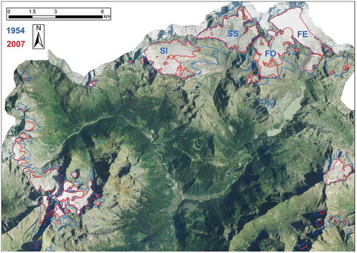
Table 1. The 41 glaciers we analysed (since they are common to all the database). The coordinates here reported are referred to the WGS84 System and describe the mean geographic location of each glacier.
The size and features of Bernina glaciers are important, particularly when compared against other mountain groups with similar elevation range.
Scerscen Superiore, Scerscen Inferiore, Fellaria Est and Fellaria Ovest are the main glacier bodies of the Bernina group – Italian sector (4.92, 4.80, 4.85, and 4.35 km2, respectively, see Figure 1 where these glaciers are labelled as SS, SI, FE, and FO, and where the coordinates are reported as well).
Previous studies on the Bernina massif, mainly performed in the Swiss territory, range from geology (e.g., Mohn, Manatschal, Beltrando, Masini, & Kusznir, Citation2012; Mohn, Manatschal, & Muntener, Citation2011), to geomorphology (e.g., reconstructions of the Holocene changes and glacier history, Hormes, Muller, & Schluchter, Citation2001; Joerin, Stocker, & Schluchter, Citation2006; Pelfini, Citation1999; Pelfini & Smiraglia, Citation1994; Pelfini, Smiraglia, & Diolaiuti, Citation2002), from remote sensing (Bolch & Kamp, Citation2006), to field glaciology (e.g., measurements of terminus fluctuations and mass balance data, Comitato Glaciologico Italiano, Comitato Glaciologico Italiano, Citation1914–1977; Citation1978–2016), from glacier modelling (Frank & Linsbauer, Citation2012; Klok, Greuell, & Oerlemans, Citation2003; Klok & Oerlemans, Citation2002; Linsbauer, Paul, Machguth, & Haeberli, Citation2013; Zekollari And Uybrechts, Citation2015), to glacier meteorology (Oerlemans, Citation2001; Oerlemans & Klok, Citation2002; Oerlemans & Knap, Citation1998), and glacier hydrology (Pellicciotti, Carenzo, Bordoy, & Stoffel, Citation2014).
Investigations at glacier forelands were performed on the Swiss sector of the Bernina Group, with a particular focus on weathering processes and soil properties and development (Arnaud, Temme, & Lange, Citation2014; Egli, Mavris, Mirabella, & Giaccai, Citation2010; Mavris et al., Citation2010), clay mineral evolution along soil chronosequences (Mavris et al., Citation2010), soil features which support plant colonization (Burga et al., Citation2010). In some cases, data from pollen and macrofossil allowed reconstruction of glacier fluctuations and reforestation of the forelands at Bernina Pass during the Late glacial period and the Holocene (Burga, Citation1999; Zoller, Athanasiadis, & Heitz-Weniger, Citation1998). The most recent researches have locally detected an upward shift of alpine plants (Gian-Reto, Beißner, & Burga, Citation2005), the consequent increasing floristic similarity of mountain summits (Jurasinski & Kreyling, Citation2007) and a shift of macroinvertebrate assemblage along the longitudinal alpine stream gradients at the base of Roseg and Tschierva glaciers (Sertić Perić, Robinson, Schubert, & Primc, Citation2015). Last but not least Fischer, Amann, Moore, and Huggel (Citation2010), Frey, Haeberli, Linsbauer, Huggel, and Paul (Citation2010), Garavaglia, Pelfini, Bini, Arzuffi, and Bozzoni (Citation2009), analysed the implications for hazard and risk conditions of changes in the landscape and in particular they focus on: slope instability phenomena, glacier lake formation, and debris flow fans, respectively. Finally, the Bernina landscape has been considered also for peculiarities of its railway (the highest one of Europe) (Bebi, Citation2011; Boksberger, Anderegg, & Schuckert, Citation2011) and for the role it plays in promoting tourism in these areas. At the knowledge of the authors of this paper in the Italian sector of the Bernina Group no previous studies over long time frame (50 years or more) focusing on magnitude and rates of glacier changes and/or on expansion glacier forelands were performed.
3. Data collection and methods
In order to evaluate glacier area changes for the whole Italian sector of the Bernina group over the last 50 years, we analysed aerial photos and orthophotos dating back since 1954 until 2007. We compiled the 1954, 1981, 2003, and 2007 records by defining glacier outlines upon the aerial photographs (1954 and 1981 stereo pairs) and the orthophotos (2003 and 2007 digital colour images).
The 2003 and 2007 data were obtained by manually digitizing the glacier boundaries upon registered colour digital orthophotos (named Volo Italia, 2003 and Volo Italia, 2007, by Compagnia Generale Riprese Aeree – CGR (CGR Citation2003, Citation2007), featuring a planimetric accuracy equal to ± 1 m). These orthophotos are purchasable products (distributed by CGR), featuring a planimetric resolution specified by 1 pixel with size 0.5 m × 0.5 m.
Concerning the 1954 and 1981 records, they were obtained by analysing the stereo pairs (aerial photos at a scale of c. 1:20,000) with an optical stereoscopic system to obtain a 3D view of the glacierized area. Then, the glacier limits observed upon the photos were reported as polygons in a GIS environment. The 1:10,000 scale Technical Regional Map (CTR) of Lombardy Region was used as a raster base. The topographic data reported in the CTR are referred to the beginning of the Eighties of the past century, thus allowing the evaluation of the reliability and accuracy of our findings from the 1981 aerial photos. The planimetric accuracy of the 1954 and 1981 data is ± 5 m.
The glacier area records (i.e., 1954, 1981, 2003 and 2007) we developed were compared together to evaluate both glacier shrinkage and forelands expansion in the period 1954–2007 and in the time windows 1954–1981, 1981–2003, and 2003–2007.Furthermore, to describe features and characteristics of the glacier forelands we overlapped the 1954 and 2007 glacier boundaries using as base layer the 2007 orthophoto. Then by visual inspection we investigated the areas abandoned by ice in the 1954–2007 time window evaluating the extent of: (i) exposed rock areas, (ii) unconsolidated sediments, and (iii) water ponds and newly formed glacial lakes. This analysis permitted to describe not only the extent and the enlargement rates of the glacier forelands but also their features.
The area values we computed feature a final planimetric precision value which was evaluated according to Vögtle and Schilling (Citation1999) and Minora et al. (Citation2016). The area precision for each glacier was evaluated by buffering the glacier perimeter, considering the area uncertainty (Linear Resolution Error or LRE). The LRE is generally considered as half the resolution of the image pixel, that is, in our case 0.5 m for the 2003 and 2007 imagines and 2.5 m for the 1954 and 1981 data. This error may be too low for debris pixels, because glacier limits are more difficult to distinguish when ice is covered by debris (Paul et al., Citation2009). Therefore, we set the error for debris pixels to be three times that of clean ice. The precision of the whole Bernina glacier coverage was estimated as the root squared sum (RSS) of the buffer areas for 1954, 1981, 2003, and 2007:
where AEyr is the areal error of year (1954 or 1981 or 2003 or 2007), pi is the ith glacier perimeter, LREyr is the LRE of year (1954 or 1981 or 2003 or 2007), and N is the total number of glaciers in the record.
Finally, the total error in area change (AEarea change 1954–1981, 1981–2003, Citation2003–2007, and 1954–2007) was then calculated as the RSS of the areal errors related to each glacier in the 1954 and 1981, 2003 and 2007 and 1954–2007 (Equation 2 where we computed the RSS for the changes in the time window 1954–2007).
4. Results
4.1. Glacier area changes
The Bernina glacierized area was 45.18 km2 in 1954 (50 ice bodies), 39.58 km2 in 1981 (54 ice bodies), 30.58 km2 in 2003 (59 ice bodies), and 28.19 km2 in 2007 (49 glaciers) ().
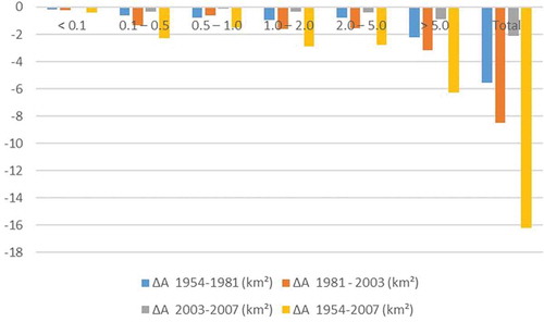
Figure 2. Glacier area change (values are reported as km2) per size classes over time.
Albeit the Bernina glaciers generally underwent losses in area (losing the largest part of their tongues) an increase in their number was observed at times (i.e., 1954–1981 and 1981–2003). This increase is caused by fragmentation of previous larger glaciers, which generates smaller ones, and it is typical of the ongoing deglaciation phase. A similar behaviour was reported, for example, by Knoll and Kerschner (Citation2009) for the Tyrolean glaciers (Eastern Alps) where more than smaller 50 glaciers derived from the disintegration of previously larger ones, and by Diolaiuti, Maragno, D’Agata, Smiraglia, and Bocchiola (Citation2011) for Dosdè Piazzi glaciers analysed in the time window 1954–2003.
In order to evaluate the area changes of Bernina glaciers we only compared the surface coverage of glaciers present in all the datasets. The records for 1954, 1981, 2003, and 2007 were considered, thus allowing to evaluate the evolution of 41 glaciers common to all the records and listed in (with the coordinates in the WGS84 System).
To analyse in more depth the relations between glacier size and area changes, the Bernina area data were analysed by classifying the glaciers according to the following size classes: < 0.10 km2, 0.10–0.5 km2, 0.5–1 km2, 1–2 km2, 2–5 km2, 5–10 km2, and >10 km2. These are the same as those applied in previous studies upon Lombardy glaciers’ shrinking (Citterio et al., Citation2007, Citation2012b; Diolaiuti et al., Citation2012a, Citation2011) upon Adamello glaciers’ variations during 1981–2003 (Maragno et al., Citation2009) and analysing Ortles Cevedale glaciers in the time window 1954–2007 (D’Agata et al., Citation2014). The same classes were initially introduced by Paul et al. (Citation2004) for Swiss glaciers, were used by Knoll and Kerschner (Citation2009) for analysing Austrian glacier changes and were used here to allow a proper comparison with the results therein.
Our data also underline that several glaciers have shifted from the largest size classes to the smallest ones. In fact, analysing glacier size distribution, it can be noticed that in the Bernina group of the 31 glaciers () with areas over 0.1 km2 in 1954, only 17 remained in 2007.
Table 2. Number of glaciers in the Bernina Group over time.
To avoid inconsistencies like the apparent gain in area for those classes that acquired more glaciers from the larger classes than they lost to the smaller ones, the area change values plotted in were obtained by crediting the contribution of each glacier according to the class it belonged to in 1954. Thus, the evaluations of area changes were not affected by class shifts.
Considering these 41 common glaciers, the Bernina glacierized area results 44.37 km2 ± 0.7% in 1954, 38.82 km2 ± 0.6% in 1981, 30.32 km2 ± 0.3% in 2003, and 28.18 km2 ± 0.3% in 2007 ( and ). The area changes between 2007 and 1954 were −16.19 km2 ± 1.3 % (−36.5 % of the area coverage in 1954), with a fastest rate in the last period; in fact, calculating the mean rate it resulted: −0.206 km2/y during 1954–1981, against −0.387 km2/y during 1981–2003, and −0.535 km2/y during 2003–2007 ().
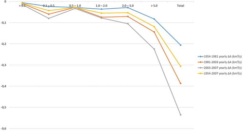
Figure 3. Mean yearly area change (km2/yr, y axis) evaluated in the different time windows (see the legend) and considering the size classes (x axis).
From it is seen that during 1954–2007 glaciers smaller than 0.1 km2 lost c. 71.6% of their initial areas. However, this strong decrease accounts for 2.7% only of the whole glacier area loss. In the 50-year long period, glaciers with their area in the range 0.1–0.5 km2 lost c. 64.4% of the surface they covered in 1954, thus contributing for 14% of the whole area loss. If we consider larger glaciers, like those in the size class 0.5–1.0 km2, they lost about 54.6% of their surface, that is, 9.2% of the total glacier reduction.
Table 3. Area coverage of glaciers in the Bernina Group over time.
Table 4. The area changes of the 41 glaciers we analysed reported as percentage with respect to the size class change and the total area change.
Glaciers in the class 1.0–2.0 km2 reduced their area by 74.8%, and their loss represents c. 17.9% of the whole glacier retreat.
Eventually, the contribution to the total area loss given by glaciers with area smaller than 1 km2 during the period 1954–2007 was 25.9% (with respect to their total coverage in 1954), lower than the contribution the greater (area > 1 km2) glaciers (which was 74.1%).
The largest glaciers (area > 5 km2) reduced their area by 25.1%, and their loss represents c. 39.1% of the whole area retreat.
Considering the different time windows of the analysis (i.e., 1954–1981, 1981–2003, and 2003–2007) one finds that the first class (<0.1 km2) always considerably decreased with respect to its previous surface coverage (by 24.5%, 50%, and 24.8% against the 1954, 1981, and 2003 area value), but still it contributed slightly to the total loss (always about 2.7%). Differently, the size class >5 km2 was the most influent upon the overall reduction. The glaciers therein decreased by 8.9% during 1954–1981, by 13.8% during 1981–2003, and by 4.6% during 2003–2007, with a contribution to the overall loss of 40.6%, 37.3%, and 42.2% respectively.
This behaviour is partially due to the different reaction times (sensu Hoelzle et al., Citation2003) characterizing each glacier size-class. In addition it may be linked to a shorter persistence of snow accumulation (Pelto, Citation2010) and is also influenced by the ongoing glacier morphological evolution (e.g., growing rock outcrops, tongue separations, formation of pro-glacial lakes, increasing supraglacial debris and collapse structures down wasting processes) and the subsequent positive feedbacks (albedo lowering, increasing long wave radiation from rock outcrops, heat storage due to supraglacial water ponds) affecting most glaciers can act as drivers of the increasing reduction rates of recent years (). These results are consistent with those reported by Paul et al. (Citation2004, Citation2007), Maragno et al. (Citation2009), Pelto (Citation2010) and Diolaiuti et al. (Citation2011), Azzoni et al. (Citation2017, Citation2018). Several of these papers underlined that increased rock outcrops are key indicators of down wasting and if these occur in the upper half-former accumulation zone a temperate glacier is expected to not survive.
4.2. Evolution of glacier forelands
As regards the ongoing widening of glacier forelands we evaluated the changes in their extent over time and we analysed features and processes.
In the time window of our analyses the Bernina glaciers abandoned an area of about 16.2 km2 ± 1.3%. This glacier reduction results in both the exposure of outcropping rocks and nunataks (1.30 km2), in the expansion of glacier forelands (14.67 km2), and in the formation of glacial lakes and water ponds (0.17 km2).
We focused our attention on the glacier forelands by analysing on the most recent orthophotos (2007 flight) their features and in particular applying a manual classification of such areas to underline if they show bare rock or unconsolidated sediments and if glacial lakes and water ponds are occurring in the areas recently abandoned by ice. In this way, 143 parcels were detected at the snout of the 41 analysed glaciers. Sixty-one (61) parcels, totally 2.65 km2 wide, resulted made by bare rock exposures and eighty-two (82) parcels, altogether 12.02 km2 wide, were found made by unconsolidated sediment, thus underling that the 82% of the newly exposed areas are subjected to runoff and meltwater actions and gravitative processes and represent unstable and potentially fast changing environments ().
Table 5. Features of the glacier forelands analysed by visual inspection of the 2007 orthophotos.
The one hundred and forty-three (143) parcels feature a wide range of size variability: the smallest ones were found 0.0009 km2 and 0.0031 km2 wide, for bare rock and unconsolidated sediment (i.e.,: till deposits), respectively; the largest ones result 1.1843 km2 and 1.2225 km2 wide, for bare rock and unconsolidated sediment, respectively.
The size of the newly exposed areas resulted linearly related with glacier area and the widest rock and debris exposures occur at the snout of the biggest glaciers ().
Moreover we also detected 18 water bodies varying their size from the maximum value of 0.052 km2 (found analysing the lake in the proglacial area of Scerscen Inferiore glacier, see geolocation in ) to the minimum of 0.0003 km2 (featured by the Lake in the foreland of Pizzo Varuna Glacier, see geolocation in ). The mean lake size is found equal to 0.015 km2 and altogether the 18 lakes cover an area of 0.17 km2.
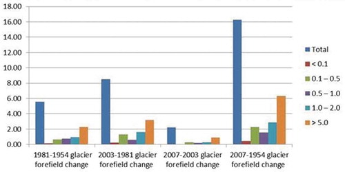
As regards the temporal evolution of such phenomena, from . it can be noticed that the widest enlargement of the proglacial areas occurred in the time frame 1981–2003 (more than 50% of the total deglaciation) and the result is the same considering all the glacier size classes thus suggesting this period was the most important in offering new environments.
Figure 4. Diagram showing the area abandoned by glaciers and then acquired by forelands in the time windows we analysed (1954–1981, 1981–2003, and 2003–2007). The purple bars indicate enlargement of areas abandoned by glaciers smaller than 1 km2, the green bars indicate increases of zones abandoned by glaciers in the range 0.1–0.5 km2, the violet bars indicate areas free from glaciers ranging from 0.5–1.0 km2, the light blue bars indicate areas deglaciated from glaciers 1.0–2.0 km2 wide and the brown bars indicate areas deriving from retreating glaciers wider than 5.0 km2.
Field investigations performed on some selected glacier forefield areas by the authors of this contribution suggested that whenever present, debris and unconsolidated sediment at glacier forelands are generally thicker than 0.5 m and, in several cases, they reach 1 m of depth. Considering such depth values featured by the debris layer mantling the 12.02 km2 of glacier forelands it gives a rock debris volume ranging from 0.006 to 0.012 km3. This material is continuously reworked, transported and re-deposited by meltwater and runoff, by gravitative processes and makes highly dynamic and fast changing these pristine areas.
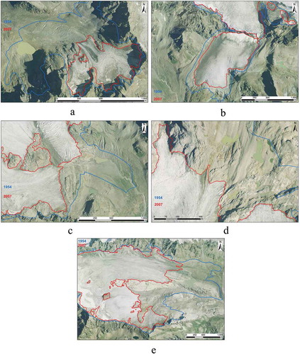
An example of the changes occurred at the glacier fore fields is appreciable in where close-up images are shown.
Figure 5. (a) Caspoggio glacier (570,507 E, 5,131,991 N): it is appreciable a newly formed lake in the glacier foreland, moreover unconsolidated sediment and a bare rock area (i.e., roche moutonée) are also visible in the flat area which is strongly re-worked by meltwater. (b) Fellaria est glacier (573,364 E, 5,135,156 N): a proglacial lake is visible on the left hydrographical side, this was in the past (i.e., 1954) an ice contact lake; moreover also unconsolidated sediment re-worked by meltwater is present. A rock exposure (i.e., roche montonée) is also visible. (c) Fellaria Ovest glacier (571,746 E, 5,133,777 N): a newly formed lake is present in the glacier foreland area. Unconsolidated sediment reworked by melting water is also visible together with a wide flat area featuring vegetation (shrubby and grass one) occurrence. (d) Pizzo Scalino glacier (575,946 E, 5,125,974 N): seven newly formed lakes are visible in the glacier foreland area. (e) Scerscen Inferiore glacier (565,177 E, 5,133,396 N): a newly formed lake is present, moreover also unconsolidated sediment and bare rock areas are visible.
5. Discussion and conclusion
The above reported data describing the recent retreat of glaciers and the expansion of forefields in the Bernina group give clear evidence of the rapid and accelerating climate change impacts affecting the high mountain environment and its surrounding.
In fact, the analysis of Bernina glaciers here performed underlines a stronger reduction of glacier coverage over half a century as well as an increasing widening of proglacial areas.
The glacier area change between 2007 and 1954 was −16.2 ± 0.4 km2 (−36.5% of the area coverage in 1954).
The glacier surface reduction is enhanced more recently; the area change during was −2.14 km2 in the period 2003–2007 (4 years, average value −0.535 km2/y), −8.51 km2 in the time window 1981–2003 (22 years, average value −0.387 km2/y), and −5.55 km2 for the interval 1954–1981 (27 years, average value −0.206 km2/y).
This glacier reduction results in both the exposure of outcropping rocks and nunataks (1.30 km2) and in the expansion of glacier forelands (14.67 km2) where proglacial lakes and water ponds are also present (0.17 km2).
The 82% of the newly exposed areas were found made by unconsolidated till deposits thus making them subject to meltwater actions, runoff and gravitative processes thus representing unstable and potentially fast changing environments. The widest enlargement of the proglacial areas occurred in the time frame 1981–2003 (more than 50% of the total deglaciation, see ) and the result is the same considering all the glacier size classes thus suggesting this period was the most important in offering new environments.
Our results about glacier reduction are consistent with glacier retreat and warming trends highlighted in the last decades at mid-latitudes (Kaab et al., Citation2002; Citterio et al., Citation2007; D’Agata et al., Citation2014; Diolaiuti et al., Citation2012b, Citation2011; Knoll & Kerschner, Citation2009; Maragno et al., Citation2009; Paul et al., Citation2007, Citation2004). Results regarding glacier forefields widening are instead a novelty as commonly such changes are not estimated.
The results here support the idea that small glaciers with narrow altitudinal range are losing more of their area, also noted in other studies (Diolaiuti et al., Citation2012b, Citation2011; Kaser & Osmaston, Citation2002; Mark & Seltzer, Citation2005; Racoviteanu, Arnaud, Williams, & Ordonez, Citation2008). This may be explained by ascent of the year round ablation zone in response to raising of the ELA under climate warming conditions (Kaser & Osmaston, Citation2002). In contrast, larger glaciers have a wider altitudinal range, with ELAs well below the maximum elevation at the glacier head.
Moreover, analysing glacier size distribution, it can be noticed that in the Bernina group of the 31 glaciers () with areas over 0.1 km2 in 1954, only 17 remained in 2007. This is critical since it is the smaller glacier sizes that have lost area proportionally the most.
Extrapolations of developments documented by repeated glacier inventories (Kaab et al., 2002; Paul et al., Citation2004) and provided by numerical models (Oerlemans & Knap, Citation1998) both suggest that the disappearance of several mountain glaciers is quite likely a matter of few decades (Haeberli, Citation2008). Also Bernina glaciers could experience such ominous scenario if no meaningful changes will occur in the climate trend.
The ongoing glacier shrinkage and the consequent proglacial area widening, are changing in a deep way the mountain landscape of Lombardy Alps (where the Italian side of Bernina Group is located), which are expected first to show features and landforms now visible within the Pyrenees (where the present glaciation is the relict of the previous one and is formed by small cirque glaciers, see González Trueba et al., Citation2008) and, in a second phase to resemble the Apennines (where only the Calderone Glacier can be found, actually classified as a debris covered glacieret together with small snow fields, see Branda et al., Citation2010; Pecci et al. Citation2008).
Geodynamically wise it is now occurring the transition from the glacial system to the paraglacial one (Ballantyne & Benn, Citation1994, Citation1996; Curry and Ballantyne, Citation1999). The areas where in the recent past the main shaping and driving factors were glaciers are now subject to the action of melting water, adding its action to the runoff one, slope evolution and dynamics and periglacial processes. Morphological changes develop at different rates in relation with shape and features of the newly exposed areas. Bare rock exposures (e.g., roches moutonneé, smoothed surfaces, etc.…) accomplish meltwater runoff while unconsolidated till deposit are unstable and can be remobilized by running waters or by gravitative processes.
Under such changing environmental features, the new territories are available for plant and trees colonization as observed in the Ortles-Cevedale Group (Garavaglia et al., Citation2010), and at the Forni glacier forefield where in the last years saples are germinating just very few years after the glacier margin retreat (Pelfini, unpublished data).
The melting of glaciers not only has obvious impacts on the surrounding ecosystems, but it also has adverse consequences upon the value of the sites where they are located, in the context of natural and geo heritage. Heritage is an irreplaceable source of life and inspiration, it is humankind’s legacy from the past, with which we live in the present and pass on to future generations (UNESCO, Citation2007).
Also the GEO-Heritage (Bosson & Reynard, Citation2012) properties could be exposed to the unfavourable effects of changing climate and this is particularly the case of mountain glaciers, among the most fascinating elements of the high elevation environment.
In fact, the consequences of glacier shrinkage on the Alpine natural and cultural heritage have not been deepened at all and only few studies have been carried out (among the others, UNESCO, Citation2007; Haeberli, Citation2008; Diolaiuti & Smiraglia, Citation2010; Garavaglia et al., Citation2010; Bollati, Smiraglia, & Pelfini, Citation2013; Bollati, Pellegrini, Reynard, & Pelfini, Citation2017; Pelfini & Bollati, Citation2014).
In this context, our study can contribute to evaluate the impacts of glacier decrease on a fragile glacierized areas, as the Bernina group, in term of impact on landscape features and related shaping processes (Bollati et al., Citation2017) and on geoheritage and geodiversity (sensu Bollati, Leonelli, Vezzola, & Pelfini, Citation2015; Eberhard, Citation1997; Gray, Citation2004; Zwolinski, Citation2004; Piacente, Citation2005; Reynard & Coratza, Citation2007; Serrano & Ruiz-Flaňo, Citation2007) or better geomorphodiversity. Further researches need to more focus on glacier foreland changes (especially sediment budget, depositional landforms evolution, etc.) as the transition from glacial to paraglacial environments implies huge changes in terms of slope connectivity, sediment transport, erosion rate, etc. (e.g., Slaymaker, Citation2011; Wilson, Citation2017). Moreover a focus on human perception of climate changes (Garavaglia, Diolaiuti, Smiraglia, Pasquale, & Pelfini, Citation2012) and related implication for glacier (Diolaiuti et al., Citation2006) and glacial forelands fruition are important as a first approach to risk education. Finally a careful dissemination of knowledge related to such fragile environments both to a general public as well as in geo-education (Garavaglia & Pelfini, Citation2011) is crucial in helping people to get awareness for what concern environmental changes under changing climatic conditions.
Disclosure statement
No potential conflict of interest was reported by the authors.
Additional information
Funding
Related Research Data
References
- Arnaud, J. A., Temme, M., & Lange, K. (2014). Pro-glacial soil variability and geomorphic activity – The case of three Swiss valleys. Earth Surface Processes And Landforms, 39, 1492–1499.
- Azzoni, R. S., Fugazza, D., Zennaro, M., Zucali, M., D’Agata, M., Maragno, D., … Diolaiuti, G. A. (2017). Recent structural evolution of Forni glacier tongue (Ortles-Cevedale Group, Central Italian Alps). Journal of Maps, 13(2), 870–878.
- Azzoni, R. S., Fugazza, D., Zerboni, A., Senese, A., D’Agata, C., Maragno, D., … Diolaiuti, G. A. (2018). Evaluating high-resolution remote sensing data for reconstructing the recent evolution of supra glacial debris a study in the Central Alps (Stelvio Park, Italy). Progress in Physical Geography, 42, 3–23.
- Ballantyne, C. K., & Benn, D. I. (1996). Paraglacial slope adjustment during recent deglaciation and its implications for slope evolution in formerly glaciated environments. In M. G. Anderson & S. M. Brooks (Eds.), Advances in hillslope processes (Vol. 2, pp. 1173–1195). Chichester: Wiley.
- Ballantyne, C. K., & Benn, D. I. (1994). Paraglacial slope adjustment and resedimentation following glacier retreat, Fabergstolsdalen, Norway. Arctic and Alpine Research, 25, 255–269.
- Bebi, J. (2011). Maintenance of overhead contact lines at Rhätische Bahn. Trade Journal ISSN: 00135437, 109(3), 135–139.
- Böhm, R., Auer, I., Brunetti, M., Maugeri, M., Nanni, T., & Schöner, W. (2001). Regional temperature variability in the European Alps: 1760–1998 from homogenized instrumental time series. International Journal of Climatology, 21, 1779–1801.
- Boksberger, P., Anderegg, R., & Schuckert, M. (2011). Structural change and re-engineering in tourism: A chance for destination governance in Grisons, Switzerland? Tourist Destination Governance Practice, Theories and Issues, 230, 145–158.
- Bolch, T., & Kamp, U. (2006). Glacier mapping in high mountains using DEMs, Landsat and ASTER Data. Grazer Schriften der Geographie und Raumforschung Band, 41(37), 48.
- Bollati, I., Leonelli, G., Vezzola, L., & Pelfini, M. (2015). The role of ecological value in geomorphosite assessment for the debris-covered miage glacier (Western Italian Alps) based on a review of 2.5 centuries of scientific study. Geoheritage, 7, 119–135.
- Bollati, I., Pellegrini, M., Reynard, E., & Pelfini, M. (2017). Water driven processes and landforms evolution rates in mountain geomorphosites: Examples from Swiss Alps. Catena, 158, 321–339.
- Bollati, I., Smiraglia, C., & Pelfini, M. (2013). Assessment and selection of geomorphosites and trails in the Miage Glacier area (Western Italian Alps). Environmental Management, 51(4), 951–967.
- Bonardi, L., Rovelli, E., Scotti, R., Toffaletti, A., Urso, M., & Villa, F. (2012). I ghiacciai della Lombardia, evoluzione ed attualità Hoepli (p. 328). Milano.
- Bosson, J. B., Deline, P., Bodin, X., Schoeneich, P., Baron, L., Gardent, M., & Lambiel, C. (2015). The influence of ground ice distribution on geomorphic dynamics since the Little Ice Age in proglacial areas of two cirque glacier systems. Earth Surface Processes And Landforms, 40(5), 666–680.
- Bosson, J. B., & Reynard, E. (2012). Geomorphological heritage, conservation and promotion in high-alpine protected areas. Eco Mont-Journal On Protected Mountain Areas Research, 4(1), 13–22.
- Brambilla, M., & Gobbi, M. (2014). A century of chasing the ice: Delayed colonisation of ice-free sites by ground beetles along glacier forelands in the Alps. Ecography, 37(1), 33–42.
- Branda, E., Turchetti, B., Diolaiuti, G., Pecci, M., Smiraglia, C., & Buzzini, P. (2010). Yeast and yeast-like diversity in the southernmost glacier of Europe (Calderone Glacier, Apennines, Italy). FEMS Microbiology Ecology, 72(2010), 354–36.
- Burga, C., Krüsi, B., Egli, M., Wernli, M., Elsener, S., Ziefle, M., … Mavris, C. (2010). Plant succession and soil development on the foreland of the Morteratsch glacier. Flora, 205(9), 561–570.
- Burga, C. A. (1999). Vegetation development on the glacier forefield Morteratsch (Switzerland). Applied Vegetation Science, 2, 17–24.
- Caccianiga, M., Andreis, C., Diolaiuti, G., D’Agata, C., Mihalcea, C., & Smiraglia, C. (2011). Alpine debris-covered glaciers as a habitat for plant life. The Holocene, 21, 1011–1020.
- Cannone, N., Diolaiuti, G., Guglielmin, M., & Smiraglia, C. (2008). Accelerating climate change impacts on alpine glacier forefield ecosystems in the European Alps. Ecological Applications, 18(3), 637–648.
- Casty, C., Wanner, H., Luterbacher, J. L., Esper, J., & Böhm, R. (2005). Temperature and precipitation variability in the European Alps since 1500. International Journal of Climatolology, 25, 1855–1880.
- Citterio, M., Diolaiuti, G., Smiraglia, C., D’Agata, C., Carnielli, T., Stella, G., & Siletto, G. B. (2007). The fluctuations of Italian glaciers during the last century: A contribution to knowledge about Alpine glacier changes. Geografiska Annaler: Series A Physical Geography, 89, 164–182.
- Comitato Glaciologico Italiano. (1914–1977). Campagne Glaciologiche. Bollettino Del Comitato Glaciologico Italiano, SI and SII, 1–25.
- Comitato Glaciologico Italiano. (1978–2016). Campagne Glaciologiche. Geografia Fisica e Dinamica Quaternaria, 1–39.
- Comitato Glaciologico Italiano – Consiglio Nazionale Delle Ricerche. (1959). Catasto dei Ghiacciai Italiani, Anno Geofisico Internazionale 1957–1958. Elenco generale e bibliografia dei ghiacciai italiani, 1, 172.
- Comitato Glaciologico Italiano – Consiglio Nazionale Delle Ricerche. (1961a). Catasto dei Ghiacciai Italiani, Anno Geofisico Internazionale 1957–1958. Ghiacciai del Piemonte. Torino, Comitato Glaciologico Italiano, 2, 324.
- Comitato Glaciologico Italiano – Consiglio Nazionale Delle Ricerche. (1961b). Catasto dei Ghiacciai Italiani, Anno Geofisico Internazionale 1957–1958. Ghiacciai della Lombardia e dell’Ortles-Cevedale.Torino, Comitato Glaciologico Italiano, 3, 389.
- Comitato Glaciologico Italiano – Consiglio Nazionale Delle Ricerche. (1962). Catasto dei Ghiacciai Italiani, Anno Geofisico Internazionale 1957–1958. Ghiacciai delle Tre Venezie (escluso Ortles-Cevedale) e dell’Appennino. Torino, Comitato Glaciologico Italiano, 4, 309.
- Compagnia Generale Riprese Aeree – CGR. (2003). Volo Italia 2003, Program “it2003”™/TerraItaly™2003”. Retrieved from http://www.terraitaly.it/product.tpl
- Compagnia Generale Riprese Aeree – CGR. (2007). Volo Italia 2007, Program “it2007”™/TerraItaly™2007”. Retrieved from http://www.terraitaly.it/product.tpl
- Cook, A. J., Fox, A. J., Vaughan, D. G., & Ferrigno, J. G. (2005). Retreating glacier fronts on the Antarctic Peninsula over the past half-century. Science, 308, 541–544.
- Curry, A. M, & Ballantyne, C. K. (1999). Paraglacial modification of glacigenic sediment. Geografiska Annaler, Series A: Physical Geography, 81, 409-419. doi:10.1111/geoa.1999.81.issue-3
- D’Agata, C., Bocchiola, D., Maragno, D., Smiraglia, C., & Diolaiuti, G. A. (2014). Glacier shrinkage driven by climate change during half a century (1954–2007) in the Ortles-Cevedale group (Stelvio National Park, Lombardy, Italian Alps). Theoretical and Applied Climatology, 116(1–2), 169–190.
- D’Amico, M. E., Freppaz, M., Leonelli, G., Bonifacio, E., & Zanini, E. (2015). Early stages of soil development on serpentinite: The proglacial area of the Verra Grande Glacier, Western Italian Alps. Journal Of Soils And Sediments, 15(6), 1292–1310.
- D’Orefice, M., Pecci, M., Smiraglia, C., & Ventura, R. (2000). Retreat of Mediterranean glaciers since the Little Ice Age: Case study of Ghiacciaio del Calderone, Central Apennines, Italy. Arctic, Antarctic and Alpine Research, 32, 197–201.
- Diolaiuti, G., Bocchiola, D., D’agata, C., & Smiraglia, C. (2012b). Evidence of climate change impact upon glaciers’ recession within the Italian alps: The case of Lombardy glaciers. Theoretical and Applied Climatology, 109(3–4), 429–445.
- Diolaiuti, G., Bocchiola, D., Vagliasindi, M., D’agata, C., & Smiraglia, C. (2012a). The 1975–2005 glacier changes in Aosta Valley (Italy) and the relations with climate evolution. Progress in Physical Geography, 36(6), 764–785.
- Diolaiuti, G., D’agata, C., Meazza, A., Zanutta, A., & Smiraglia, C. (2009). Recent (1975–2003) changes in the Miage debris-covered glacier tongue (Mont Blanc, Italy) from analysis of aerial photos and maps. Geografia Fisica e Dinamica Quaternaria, 32, 117–127.
- Diolaiuti, G., Maragno, D., D’Agata, C., Smiraglia, C., & Bocchiola, D. (2011). Glacier retreat and climate change: Documenting the last fifty years of Alpine glacier history from area and geometry changes of Dosdè Piazzi glaciers (Lombardy-Alps, Italy). Progress in Physical Geography, 35(2), 161–182.
- Diolaiuti, G., & Smiraglia, C. (2010). Changing glaciers in a changing climate: How vanishing geomorphosites have been driving deep changes on mountain landscape and environment. Géomorphologie: relief, processus, environnement (GRPE), 2, 131–152.
- Diolaiuti, G., Smiraglia, C., Pelfini, M., Belò, M., Pavan, M., & Vassena, G. (2006, April). The recent evolution of an Alpine glacier used for summer skiing (Vedretta Piana, Stelvio Pass, Italy). Cold Regions Science and Technology, 44(3), 206–216.
- Dyurgerov, M. B., & Meier, M. F. (2000). Twentieth century climate change: Evidence from Small Glaciers. Proceedings of the National Academy of Sciences, 97, 1406–1411.
- Eberhard, R. (1997). Pattern and Processes: Towards a regional approach to national estate assessment of geodiversity (Technical Series n°2). Camberra: Australian Heritage, Commission and Environment Forest Taskforce, Environment Australia, p. 102.
- ECC 92/43. Retrieved from https://eur-lex.europa.eu/legal-content/EN/TXT/PDF/?uri=CELEX:31992L0043&from=EN
- Egli, M., Mavris, C., Mirabella, A., & Giaccai, D. (2010). Soil organic matter formation along a chronosequence in the Morteratsch proglacial area (Upper Engadine, Switzerland). Catena, 82(2010), 61–69.
- Egli, M., Wernli, M., Kneisel, C., & Haeberli, W. (2006). Melting glaciers and soil development in the proglacial area Morteratsch (Swiss Alps): I. Soil type chronosequence. Arctic Antarctic And Alpine Research, 38(4), 499–509.
- Falaschi, D., Bravo, C., Masiokas, M., Villalba, R., & Rivera, A. (2013). First glacier inventory and recent changes in glacier area in the Monte San Lorenzo Region (47 degrees S), Southern Patagonian Andes, South America. Arctic Antarctic And Alpine Research, 45(1), 19–28.
- Fischer, L., Amann, F., Moore, J. R., & Huggel, C. (2010). Assessment of periglacial slope stability for the 1988 Tschierva rock avalanche (Piz Morteratsch, Switzerland). Engineering Geology, 116(1–2), 32–43.
- Fischer, M., Huss, M., Barboux, C., & Hoelzle, M. (2014). The new Swiss Glacier Inventory SGI2010: Relevance of using high-resolution source data in areas dominated by very small glaciers. Arctic, Antarctic, and Alpine Research, 46(4), 933–945.
- Frank, P., & Linsbauer, A. (2012). Modeling of glacier bed topography from glacier outlines, central branch lines, and a DEM. International Journal of Geographical Information Science, 26(7), 1173–1190.
- Frey, H., Haeberli, W., Linsbauer, A., Huggel, C., & Paul, F. (2010). A multi-level strategy for anticipating future glacier lake formation and associated hazard potentials. Natural Hazards and Earth System Sciences, 10, 39–352.
- Frezzotti, M., & Orombelli, G. (2014). Glaciers and ice sheets: Current status and trends. Rendiconti Lincei-Scienze Fisiche E Naturali, 25(1), 59–70.
- Fugazza, D., Scaioni, M., Corti, M., D’Agata, C., Azzoni, R. S., Cernuschi, M., … Diolaiuti, G. A. (2018). Combination of UAV and terrestrial photogrammetry to assess rapid glacier evolution and map glacier hazards. Natural Hazards and Earth System Sciences, 18, 1055–1071.
- Garavaglia, V., Diolaiuti, G., Smiraglia, C., Pasquale, V., & Pelfini, M. (2012). Evaluating tourist perception of environmental changes as a contribution to managing natural resources in glacierized areas: A case study of the Forni Glacier (Stelvio National Park, Italian Alps). Environmental Management, 50(6), 1125–1138.
- Garavaglia, V., & Pelfini, M. (2011). Glacial geomorphosites and related landforms: A proposal for a dendrogeomorphological approach and educational trails. Geoheritage, 3, 15–25.
- Garavaglia, V., Pelfini, M., Bini, A., Arzuffi, L., & Bozzoni, M. (2009). Recent evolution of debris-flow fans in the Central Swiss Alps and associated risk assessment: Two examples in Roseg Valley. Physical Geography, 30(2), 105–129.
- Garavaglia, V., Pelfini, M., & Motta, E. (2010). Glacier stream activity in the proglacial area of an italian debris covered glacier: An application of dendroglaciology. Geografia Fisica e Dinamica Quaternaria, 33(1), 15–24.
- Gardent, M., Rabatel, A., Dedieu, J. P., & Deline, P. (2014). Multitemporal glacier inventory of the French Alps from the late 1960s to the late 2000s. Global and Planetary Change, 120, 24–37.
- Geilhausen, M., Morche, D., Otto, J. C., & Schrott, L. (2012). Sediment discharge from the proglacial zone of a retreating Alpine glacier. Zeitschrift Fur Geomorphologie, 57(2), 29–53.
- Gian-Reto, W., Beißner, S., & Burga, C. A. (2005). Trends in the upward shift of alpine plants. Journal of Vegetation Science, 16, 541–548.
- Gobbi, M., Rossaro, B., Vater, A., De Bernardi, F., Pelfini, M., & Brandmayr, P. (2007). Environmental features influencing Carabid beetle (Coleoptera) assemblages along a recently deglaciated area in the Alpine region. Ecological Entomology, 32, 282–289.
- González Trueba, J. J., Martín Moreno, R., Martínez de Pisón, E., & Serrano, E. (2008). “Little Ice Age” glaciation and current glaciers in the Iberian Peninsula. The Holocene, 18, 551–568.
- Gray, M. (2004). Geodiversity valuing and conserving abiotic nature (pp. 434). Chichester: Wiley.
- Haeberli, W. (2008). Changing view of Changing glaciers. In B. Orlove, E. Wiegandt, & B. H. Luckman (Eds.), Darkening Peaks: Glacier retreat, science and society (pp. 23–32). Los Angeles: University of California Press.
- Haeberli, W., & Beniston, M. (1998). Climate change and its impacts on glaciers and permafrost in the Alps. Ambio, 27, 258–265.
- Hoelzle, M., Haeberli, W., Dischl, M., & Peschke, W. (2003). Secular glacier mass balances derived from cumulative glacier length changes. Global and Planetary Change, 36, 295–306.
- Hormes, A., Muller, B. U., & Schluchter, C. (2001). The Alps with little ice: Evidence for eight Holocene phases of reduced glacier extent in the Central Swiss Alps. The Holocene, 11(3), 255–265.
- Hughes, P. D. (2009). Twenty-first Century Glaciers in the Prokletije Mountains, Albania. Arctic, Antarctic and Alpine Research, 4, 455–459.
- Hughes, P. D. (2010). Little Ice Age glaciers in Balkans: Low altitude glaciation enabled by cooler temperatures and local topoclimatic controls. Earth Surface Processes and Landforms, 35, 229–241.
- IPCC. (2013) Summary for policymakers. In: Climate Change 2013: The Physical Science Basis Contribution of. Working Group I to the Fifth Assessment Report. Retrieved from http://www.climatechange2013.org/images/report/WG1AR5_SPM_FINAL.pdf
- Joerin, U. E., Stocker, T. F., & Schluchter, C. (2006). Multicentury glacier fluctuations in the Swiss Alps during the Holocene. The Holocene, 16, 697–704.
- Jurasinski, G., & Kreyling, J. (2007). Upward shift of alpine plants increases floristic similarity of mountain summits. Journal of Vegetation Science, 18, 711–718.
- Kääb, A., Paul, F., & Maisch, M. (2002). The new remote sensing derived swiss glacier inventory: II. First results. Annals of Glaciology, 34(1), 362–366.
- Kabala, C., & Zapart, J. (2012). Initial soil development and carbon accumulation on moraines of the rapidly retreating Werenskiold Glacier, SW Spitsbergen, Svalbard archipelago. Geoderma, 175, 9–20.
- Kaser, G., Cogley, J. C., Dyurgerov, M. B., Meier, M. F., & Ohmura, A. (2006). Mass balance of glaciers and ice caps: Consensus estimates for 1961–2004. Geophysical Research Letters, 33, L19501.
- Kaser, G., & Osmaston, H. (2002). Tropical glaciers. Cambridge, UK: Cambridge University Press.
- Klok, E. J., Greuell, W., & Oerlemans, J. (2003). Temporal and spatial variation of the surface albedo of Morteratschgletscher, Switzerland, as derived from 12 Landsat images. Journal of Glaciology, 48(163), 491–502.
- Klok, E. J., & Oerlemans, J. (2002). Model study of the spatial distribution of the energy and mass balance of Morteratschgletscher, Switzerland. Journal of Glaciology, 48(163), 505–518.
- Knoll, C., & Kerschner, H. (2009). A glacier inventory for South Tyrol, Italy, based on airborne laser scanner data. Journal of Glaciology, 50, 46–52.
- Kuhn, M. (1980). Climate and glaciers. Iahs, 131, 3–20.
- Lambrecht, A., & Kuhn, M. (2007). Glacier changes in the Austrian Alps during the last three decades, derived from the new Austrian glacier inventory. Annals of Glaciology, 46, 177–184.
- Leonelli, G., Coppola, A., Baroni, C., Salvatore, M. C., Maugeri, M., Brunetti, M., & Pelfini, M. (2016). Multispecies dendroclimatic reconstructions of summer temperature in the European Alps enhanced by trees highly sensitive to temperature. Climatic Change, 137(1–2), 275–291.
- Levy, A., Robinson, Z., Krause, S., Waller, R., & Weatherill, J. (2015). Long-term variability of proglacial groundwater-fed hydrological systems in an area of glacier retreat, Skeioararsandur, Iceland. Earth Surface Processes And Landforms, 40(7), 981–994.
- Linsbauer, A., Paul, F., Machguth, H., & Haeberli, W. (2013). Comparing three different methods to model scenarios of future glacier change in the SwissAlps. Annals Of Glaciology, 54(63), 241–253, Part: 2.
- Maisch, M. (2000). The longterm signal of climate change in the Swiss Alps. Glacier retreat since the Little Ice Age and future ice decay scenarios. Geografia Fisica e Dinamica Quaternaria, 23, 139–152.
- Maragno, D., Diolaiuti, G., D’Agata, C., Mihalcea, C., Bocchiola, D., Bianchi Janetti, E., … Smiraglia, C. (2009). New evidence from Italy (Adamello Group, Lombardy) for analysing the ongoing decline of Alpine glaciers. Geografia Fisica e Dinamica Quaternaria, 32, 31–39.
- Mark, B. G., & Seltzer, G. O. (2005). Evaluation of recent glacier recession in the Cordillera Blanca, Peru (AD 1962–1999): Spatial distribution of mass loss and climatic forcing. Quaternary Science Reviews, 24(20–21), 2265–2280.
- Mavris, C., Egli, M., Plötze, M., Blum, J. D., Mirabella, A., Giaccai, D., & Haeberli, W. (2010). Initial stages of weathering and soil formation in the Morteratsch proglacial area (Upper Engadine, Switzerland). Geoderma, 155(3–4), 359–371.
- Meola, M., Lazzaro, A., & Zeyer, J. (2014). Diversity, resistance and resilience of the bacterial communities at two alpine glacier forefield safter a reciprocal soil transplantation. Environmental Microbiology, 16(6), 1918–1934.
- Mergili, M., Kopf, C., & Muellebner, B. (2012). Changes of the cryosphere and related geohazards in the high-mountain areas of Tajikistan and Austria: A comparison. Geografiska Annaler Series A-Physical Geography, 94A(1 Special Issue), 79–96.
- Minora, U., Bocchiola, D., D’Agata, C., Maragno, D., Mayer, C., Lambrecht, A., … Diolaiuti, G. (2016). Glacier area stability in the Central Karakoram National Park (Pakistan) in 2001–2010: The “Karakoram Anomaly” in the spotlight. Progress in Physical Geography, 1–32. doi:10.1177/0309133316643926
- Mohn, G., Manatschal, G., Beltrando, M., Masini, E., & Kusznir, N. (2012). Necking of continental crust in magma-poor rifted margins: Evidence from the fossil Alpine Tethys margins. Tectonics, 31(TC1012). doi:10.1029/2011TC002961
- Mohn, G., Manatschal, G., & Muntener, O. (2011). Rift-related from the Austroalpine SE-Switzerland. International Journal of Earth Sciences (Geologische Rundschau), 100, 937–961.
- Moreau, M., Mercier, D., Laffly, D., & Roussel, E. (2006). Impacts of recent paraglacial dynamics on plant colonization: A case study on Midtre Lovenbreen foreland, Spitsbergen (79 degrees N). Geomorphology, 95(1–2), 48–60.
- Oerlemans, J. (2001). Glaciers and Climate Change. Rotterdam: A.A. Balkema Publishers.
- Oerlemans, J. (2005). Extracting a climate signal from 169 glacier records. Science, 308, 675–677.
- Oerlemans, J., & Klok, E. J. (2002). Energy balance of a glacier surface: Analysis of AWS data from the Morteratschgletscher, Switzerland. Arctic, Antarctic and Alpine Research, 34(123), 115–123.
- Oerlemans, J., & Knap, W. H. (1998). A 1 year record of global radiation and albedo in the ablation zone of Morteratschgletscher, Switzerland. Journal of Glaciology, 44(147), 231–238.
- Patzelt, G. (1985). The period of glacier advances in the Alps, 1965 to 1980. Zeitschrift für Gletscherkunde und Glazialgeologie, 21, 403–407.
- Paul, F., Barry, R. G., Cogley, J. G., & Frey, H. (2009). Recommendations for the compilation of glacier inventory data from digital sources. Annals of Glaciology, 50(53), 119–126.
- Paul, F., Frey, H., & Le Bris, R. (2011). A new glacier inventory for the European Alps from Landsat TM scenes of 2003: Challenges and results. Annals of Glaciology, 52(59), 144–152.
- Paul, F., Kääb, A., & Haeberli, W. (2007). Recent glacier changes in the Alps observed from satellite: Consequences for future monitoring strategies. Global and Planetary Change, 56, 111–122.
- Paul, F., Kääb, A., Maisch, M., Kellenberger, T., & Haeberli, W. (2004). Rapid disintegration of Alpine glaciers observed with satellite data. Geophysical Research Letters, 31, L21402.
- Pecci, M., D’Agata, C., & Smiraglia, C. (2008). Ghiacciaio del Calderone (Apennines, Italy): The mass balance of a shrinking Mediterranean glacier. Geografia Fisica E Dinamica Quaternaria, 31(1), 55–62.
- Pelfini, M. (1999). Dendrogeomorphological study of glacier fluctuations in the Italian Alps during the Little Ice Age. Annals of Glaciology, 28, 123–128.
- Pelfini, M., & Bollati, I. (2014). Landforms and geomorphosites ongoing changes: Concepts and implications for geoheritage promotion. Quaestiones Geographicae, 33(1), 131–143.
- Pelfini, M., Diolaiuti, G., Leonelli, G., Bozzoni, M., Bressan, N., Brioschi, D., & Riccardi, A. (2012). The influence of glacier surface processes on the short-term evolution of supraglacial tree vegetation: The case study of the Miage Glacier, Italian Alps. The Holocene, 22(8), 847–857.
- Pelfini, M., & Leonelli, G. (2014). First results of the participatory approach for monitoring supraglacial vegetation in Italy. Geografia Fisica e Dinamica Quaternaria, 37(1), 23–27.
- Pelfini, M., Leonelli, G., Trombino, L., Zerboni, A., Bollati, I., Merlini, A., … Diolaiuti, G. (2014). New data on glacier fluctuations during the climatic transition at similar to 4,000 cal. year BP from a buried log in the Forni Glacier forefield (Italian Alps). Rendiconti Lincei-Scienze Fisiche e Naturali, 25(4), 427–437.
- Pelfini, M., Santilli, M., Leonelli, G., & Bozzoni, M. (2007). Investigating surface movements of debris-covered Miage glacier,Western Italian Alps, using dendroglaciological analysis. Journal of Glaciology, 53(180), 141–152.
- Pelfini, M., & Smiraglia, C. (1994). Nuove ipotesi sulla massima espansione olocenica del Ghiacciaio della Ventina (Valtellina, Alpi Retiche). Geografia Fisica e Dinamica Quaternaria, 17, 103–106.
- Pelfini, M., Smiraglia, C., & Diolaiuti, G. (2002). I Ghiacciai della Val Sissone (Valtellina, Alpi Retiche) e la loro storia olocenica. Il Quaternario, 15(1), 3–9.
- Pellicciotti, F., Carenzo, M., Bordoy, R., & Stoffel, M. (2014). Changes in glaciers in the Swiss Alps and impact on basin hydrology: Current state of the art and future research. Science Of The Total Environment, 493, 1152–1170.
- Pelto, M. S. (2010). Forecasting temperate alpine glacier survival from accumulation zone observations. The Cryosphere, 4, 67–75.
- Pfeffer, W. T., Arendt, A. A., Bliss, A., Bolch, T., Cogley, J. G., Gardner, A. S., … Sharp, M. J., & The Randolph Consortium. (2014). The Randolph glacier inventory: A globally complete inventory of glaciers. Journal of Glaciology, 60(221), 537–552.
- Piacente, S. (2005). Geosites and geodiversity for a cultural approach to geology. In Piacente S., Coratza P. (Eds.), Geomorphological sites and geodiversity. Il Quaternario, 18, 11–14.
- Rabatel, A., Francou, B., Soruco, A., Gomez, J., Caceres, B., Ceballos, J. L., … Scheel, M. (2013). Current state of glaciers in the tropical Andes: A multi-century perspective on glacier evolution and climate change. The Cryosphere, 7(1), 81–102.
- Racoviteanu, A. E., Arnaud, Y., Williams, M. W., & Ordonez, J. (2008). Decadal changes in glacier parameters in the Cordillera Blanca, Peru, derived from remote sensing. Journal of Glaciology, 54(186), 499–510.
- Reynard, E., & Coratza, P. (2007). Geomorphosites and geodiversity: A new domain of research. Geografica Helvetica, 62, 138–139.
- Rott, H., Skvarca, P., & Nagler, T. (1996). Rapid collapse of northern Larsen Ice Shelf, Antarctica. Science, 271, 788–792.
- Salerno, F., Gambelli, S., Viviano, G., Thakuri, S., Guyennon, N., D’Agata, C., … Bocchiola, D. (2014). High alpine ponds shift upwards as average temperatures increase: A case study of the Ortles-Cevedale mountain group (Southern Alps, Italy) over the last 50 years. Global and Planetary Change, 120, 81–91.
- Schlegel, J., & Riesen, M. (2012). Environmental gradients and succession patterns of carabid beetles (Coleoptera: Carabidae) in an Alpine glacier retreat zone. Journal of Insect Conservation, 16(5), 657–675.
- Serrano, E., & Ruiz-Flaňo, P. (2007). Geodiversity. A theoretical and applied concept. Geografica Helvetica, 62, 140–147.
- Sertić Perić, M., Robinson, C. T., Schubert, C. J., & Primc, B. (2015). Stable isotopes as proxies for food sourcing in alpine streams undergoing glacial recession ESIR Isotope Workshop XIII - Book of Abstracts/Krajcar Bronić, Ines; Horvatinčić, Nada; Obelić, Božidar (ur.) (pp. 49). Zagreb: Ruđer Bošković Institute. (ISBN: 978-953-7941-08-6).
- Slaymaker, O. (2011). Criteria to distinguish between periglacial, proglacial and paraglacial environments. Quaestiones Geographicae, 30(1), 85–94.
- Smiraglia, C., Azzoni, R. S., D’Agata, C., Maragno, D., Fugazza, D., & Diolaiuti, G. A. (2015). The evolution of the Italian glaciers from the previous data base to the New Italian Inventory. Preliminary considerations and results. Geografia Fisica e Dinamica Quaternaria, 38(1), 79–87.
- Smiraglia, C., & Diolaiuti, G. (Eds.). (2015). The New Italian Glacier Inventory (p. 400). Bergamo: Ev-K2-CNR Publ. Retrieved from http://users.unimi.it/glaciol
- Sommaruga, R. (2015). When glaciers and ice sheets melt: Consequences for planktonic organisms. Journal of Plankton Research, 37(3), 509–518.
- Staines, K. E. H., Carrivick, J. L., Tweed, F. S., Evans, A. J., Russell, A. J., Johannesson, T., & Roberts, M. (2015). A multi-dimensional analysis of pro-glacial landscape change at Solheimajokull, southern Iceland. Earth Surface Processes And Landforms, 40(6), 809–822.
- St-Hilaire, V. M., & Smith, D. J. (2017). Holocene glacier history of Frank Mackie Glacier, northern British Columbia Coast Mountains. Canadian Journal of Earth Sciences, 54(1), 76–87.
- Turchetti, B., Buzzini, P., Goretti, M., Branda, E., Vaughan-Martini, A., Diolaiuti, G., … Smiraglia, C. (2008). Psychrophilic yeasts in glacial environments of Alpine glaciers. FEMS Microbiology Ecology, 63, 73–83.
- UNESCO. (2007). Case studies on climate change and world heritage (p. 82). Retrieved from http://whc.unesco.org/en/activities/473/
- Vogtle, T., & Schilling, K. J. (1999). Digitizingmaps. In H.-P. Bahr & T. Vogtle (Eds.), Error modelling in GIS environment, GIS for environmental monitoring (Chap. 3, pp. 201–216). Stuttgart, Germany: Schweizerbart.
- Wang, X., Siegert, F., Zhou, A. G., & Franke, J. (2013). Glacier and glacial lake changes and their relationship in the context of climate change, Central Tibetan Plateau 1972–2010. Global and Planetary Change, 111, 246–257.
- Wilson, P. (2017). Periglacial and Paraglacial Processes, Landforms and Sediments. In P. Coxon, S. McCarron, & F. Mitchell (Eds.), Advances in Irish quaternary studies (Vol. 1, pp. 217–254). Atlantis Press, UK: Book Series: Atlantis Advances in Quaternary Science.
- Wood, F. (1988). Global alpine glacier trends 1960s to 1980s. Artic, Alpine and Antarctic Research, 20, 404–413.
- Zekollari, H., & Huybrechts, P. (2015). On the climate–Geometry imbalance, response time and volume–Area scaling of an alpine glacier: Insights from a 3-D flow model applied to Vadret da Morteratsch, Switzerland. Annals of Glaciology, 56(70), 51–62.
- Zemp, M., Paul, F., Hoelzle, M., & Haeberli, W. (2008a). Glacier fluctuations in European Alps 1850–2000: An overview and spatio-temporal analysis of available data. In B. Orlove, E. Wiegandt, & B. H. Luckman (Eds.), Darkening peaks: Glacier retreat, science and society (pp. 152–167). Los Angeles: University of California Press.
- Zemp, M. (2008b). United Nations environment programme, World Glacier Monitoring Service - Global glacier changes: Facts and figures. UNEP/Earthprint, 2008, 88.
- Zemp, M., Haeberli, W., Hoelzle, M., & Paul, F. (2006). Alpine glaciers to disappear within decades? Geophysical Research Letters, 33, L13504.
- Zoller, H., Athanasiadis, N., & Heitz-Weniger, A. (1998). Late-glacial and Holocene vegetation and climate change at the Palu glacier, Bernina pass, Grisons canton, Switzerland. Vegetation History and Archaeobotany, 7(4), 241–249.
- Zwolinski, Z. (2004). Geodiversity. In A. S. Goudie (Ed.), Encyclopaedia of geomorphology (Vol. 1, pp. 417–418). London: Routledge.