
ABSTRACT
While previous socio-ecological systems research has shown relationships between local knowledge and the assignment of landscape values, the relationships between value assignment and more nuanced forms of local knowledge remain less understood. This study makes use of public participation geographic information systems (PPGIS), a method for identifying and mapping landscape attributes important to local communities. We use this method to assess the spatial associations between three landscape attributes often overlooked in the PPGIS literature: landscape values, self-reported knowledge about different types of landscape management practices and land-use types. We analyzed responses from residents of Mjölby kommun, Sweden (n = 301) using Monte Carlo simulations and density-based clustering. Overall, we found stronger spatial associations between landscape values and land-use types compared with landscape values and self-reported knowledge about landscape management. For example, significant positive associations were found between aesthetic and recreation values and certain land-use types, but there was no association between these values and self-reported knowledge. The land-use type to which a landscape value is assigned is sometimes supported by self-reported knowledge (especially for underrepresented landscape values), while self-reported knowledge did not provide a conclusive pattern about value assignment on its own. We discuss the implications of using PPGIS in integrated landscape management for building multifunctionality in landscape management by addressing the values of different land-use stakeholders, and the potential benefits of increased inclusivity in forms of local knowledge.
EDITED BY:
Introduction
The ‘relational turn’ in ecosystem management is characterized by a shift away from focusing on separate interactions towards emphasizing unfolding relationships between humans and ecosystems (West et al. Citation2020), stemming from the relational values concept, which describes those values deriving from relationships between humans and nature (Chan et al. Citation2016). This relational turn invites consideration of diverse knowledges for decision-making, as well as an appreciation of the inherent uncertainty in all knowledge systems (Tengö et al. Citation2017). The Intergovernmental Science-Policy Platform on Biodiversity and Ecosystem Services (IPBES) frequently emphasize the importance of expert and scientific forms of information (Díaz et al. Citation2015), as well as the inclusion of plural values and knowledge into decision-making, defined as the recognition of differing values held by diverse stakeholders that cannot be reduced to one another or to some ultimate value (Arias-Arévalo et al. Citation2017; Pereira et al. Citation2018; Zafra-Calvo et al. Citation2020). Yet knowledge among experts is also diverse, taking account of different epistemic worldviews and understandings of human-nature relationships (Hakkarainen et al. Citation2020). In some cases, a distinction is made between generalizable and context-specific knowledge, in order to recognize the importance of local communities’ knowledges and place-based experiences (Díaz et al. Citation2018). To partially account for this complexity, new processes are being developed to work with indigenous, local and scientific knowledge, including empowering dialogues and shared governance arrangements, and promoting activities in-situ where knowledge can be validated (Tengö et al. Citation2017; Hill et al. Citation2020). At the same time, issues surrounding the temporal nature of landscape management have prompted a greater recognition of the contemporary processes that shape how humans connect with their environment (Stenseke Citation2016). While an inherently complex process, considering local knowledge alongside other knowledge types in landscape management has the potential to address these spatial and temporal issues (Raymond et al. Citation2010).
To date, the public participation geographic information systems (PPGIS) literature has exhibited a less-nuanced understanding of the diversity of knowledge systems, and how to weave them to support landscape management. Despite the existence of multiple forms of local knowledge (Raymond et al. Citation2010; Fazey et al. Citation2018, Citation2020), much of PPGIS research has focused on experiential place-based knowledge, i.e. local knowledge from the perspective of familiarity, or personal or social experiences with landscape. Brown (Citation2012) refers to this understanding of place from lived experience as a ‘type of knowledge that is earned rather than learned’ (p. 8). It is often operationalized using the indicator of familiarity with an entire region. For example, respondents’ knowledge of the study area has been observed to influence the type and amount of spatial data they map in PPGIS studies (Brown and Kyttä Citation2014), as well as the overall mapping effort (Brown et al. Citation2012). Survey respondents less familiar with an area are more likely to map abstract, nonexperiential landscape values (e.g. intrinsic values) compared with those with greater study area familiarity (Brown, Citation2004). When comparing results across three PPGIS studies in National Forests in the U.S., Brown and Reed (Citation2009) found that respondents who report more familiarity with a given area tend to identify more landscape values and special places (those important to survey participants) than respondents reporting less familiarity. The spatial distribution of landscape values can also vary according to respondents’ knowledge about the region. Raymond and Brown (Citation2007) found that tourists with less overall knowledge of the region were more likely to assign values to popular locations along the Great Ocean Road in Victoria, Australia, or in the Otway Hinterland, whereas residents with higher knowledge of the region assigned more values and indicated more hotspots of landscape values across the region. Similarly, Munro et al. (Citation2017) found that visitor mapping hotspots largely correspond to well-known tourism destinations.
Experiential place-based knowledge is also considered with respect to the consistency between landscape values and specific land-use types (Brown Citation2015; Brown et al. Citation2018). This approach is displayed in multiple studies; for example, depending on sub-group, recreational or instrumental values can be more tightly clustered along roads (Brown Citation2013; Sherrouse et al. Citation2014; van Riper et al. Citation2020) or in villages (Fagerholm et al. Citation2012). Conversely, symbolic and intrinsic values tend to be assigned more diffusively across the landscape, often in natural areas (Raymond and Brown Citation2006). Proportionately more values for ecosystem services may be assigned to forest areas and waterbodies, and fewer to agricultural areas (Raymond et al. Citation2009; Brown and Brabyn Citation2012; Brown Citation2013). Also, participants tend to favor tourism and oppose land development in protected areas (Raymond and Brown Citation2006; Engen et al. Citation2018), although samples of residents can have conflicting values about the development of tourism in natural areas (Plieninger et al. Citation2018). However, differences in local knowledge may not always be spatially manifested. For example, while frontcountry and backcountry recreationists in Denali National Park, Alaska, could be distinguished based on their level of local knowledge about certain aspects of Denali’s natural resources, the spatial differences in value assignment were less apparent (van Riper et al. Citation2020). Front-country respondents assigned symbolically important values in accessible locations, while backcountry respondents assigned more diverse landscape values to a broader, yet overlapping, expanse within the protected area (van Riper et al. Citation2020).
Despite these advancements, PPGIS literature to date has placed little emphasis on the relationship between self-reported knowledge (knowledge that comes from local communities about a specific topic or location), landscape values and land-use types. It is critical to surface relationships between knowledge, landscape values and land-use types in order to contextualize landscape management policies by accounting for the landscape management knowledge of regional populations. Self-reported knowledge about a specific topic or location can be reported by respondents based on Likert scales (see, for example, Raymond and Brown Citation2007; Kearney and Bradley Citation2011; van Riper et al. Citation2017; Vulturius et al. Citation2020) and can be influenced by multiple individual and socio-economic factors, such as level of education on a given topic, personal experiences and cultural influences, or interactions across these (Munro and Moore Citation2005; Pannell et al. Citation2006; Gifford and Nilsson Citation2014; Varghese and Crawford Citation2020). Discrepancies between self-reported and objectively assessed knowledge in an individual suggest that these knowledge metrics should be regarded critically (Stoutenborough and Vedlitz Citation2014). Connections have been made between high levels of self-reported environmental knowledge about the environment and pro-environmental or ecological behavior (Fielding and Head Citation2012; Otto and Pensini Citation2017). Similarly, self-reported knowledge aligns with the premise of ‘ideologically motivated cognition’ in which high levels of knowledge about the environment correlate with ideological commitments to protect it (Drews and van den Bergh Citation2016, p. 6).
In this study, we aim to examine the relationships between self-reported knowledge about landscape management (hereafter self-reported knowledge), landscape values and land-use types. In doing so, we highlight a critical question about how eliciting diverse forms of local knowledges and values can contribute to integrated landscape management in practice. We argue that combining a more nuanced understanding of local knowledge together with spatial assessments of the relationships between landscape values and land-use types will enable landscape management practitioners and scientists to target landscape management to both diverse values and knowledges.
Materials and methods
Study area
Mjölby municipality, or Mjölby kommun, is in Sweden’s Östergötland County in the south-central portion of the country, about 10 km from Lake Vättern. The municipality is 557.2 square kilometers in size (), part of Östergötland’s multifunctional landscape composed of meadows, forests, and oak wood-pastures (Garrido et al. Citation2017). These areas are not only valued for cultural, recreational and aesthetic reasons but are also some of the most biodiverse habitats in Sweden (Garrido et al. Citation2017). Silvo-pastoralist activities feature heavily, in which grazing and forestry are handled as a mixed land-use entity, molding a unique landscape that presents specific challenges for conservation and the continuation of traditional landscape uses (Garrido et al. Citation2017; Torralba et al. Citation2018). Primary drivers contributing to the deterioration of oak wood-pasture landscapes include the loss of traditional grazing systems and land abandonment (Torralba et al. Citation2018).
Figure 1. Map displaying location of study site within Östergötland County, Sweden, with inset displaying Mjölby kommun and 2 kilometer buffer zone used for data analysis.
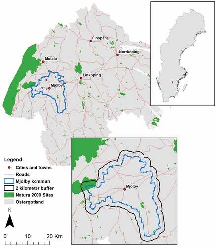
The study area is predominantly composed of agricultural and forest and semi-natural areas (CLC Citation2018). The largest land-use types are non-irrigated arable land, which features in the north of the study site, and coniferous forests, which occur mainly in the south. A total of approximately 9.8 square kilometers of Mjölby kommun are protected as Natura 2000 sites (Natura Citation2000Data- the European Network of Protected Sites, 2020). Importantly, Mjölby kommun is home to the Natura 2000 site Västra Harg, a small yet locally important protected area in the southern portion of the municipality. The protection of the mixed-use landscapes found here and in the rest of Mjölby kommun tie closely with Sweden’s environmental policy objectives: for example, the stated goals of sustainable forestry, a varied agricultural landscape, and a rich diversity of plant and animal life. These objectives are affected by intensive land-use and land abandonment, affecting cultural heritage in connection with the landscape (Sverige Citation2013).
Sampling and survey administration
We conducted a random sample of 1,200 property owners in Mjölby kommun, with no minimum requirement for length of residence in the municipality (data provided by the Swedish governmental agency Lantmäteriet). In May 2019, we sent these individuals a postal survey invitation, which provided an overview of the purpose and scope of the research, a link to the online survey, and information necessary to comply with human research ethics and GDPR requirements at the University of Helsinki. This included a privacy statement concerning how participant data would be used during and after the project. We sent a reminder letter in July 2019, a month prior to the survey closing.
Survey technique
We designed a PPGIS survey in order to collect data about the landscape values and self-reported knowledge about landscape management of residents in Mjölby kommun (refer to Raymond et al. Citation2010 for distinctions between knowledge types). We constructed the survey using Maptionnaire’s online software in both Swedish and English. Maptionnaire is a map-based survey tool designed to facilitate community engagement through a spatial understanding of local needs (https://maptionnaire.com). The survey took approximately 30 minutes to complete (link to survey in Swedish and English can be found at https://app.maptionnaire.com/en/6086/). Collaboration with local stakeholders in the Östergötland County Administrative Board and sustainability researchers familiar with the study site was important for the survey design, as this allowed for the inclusion of survey questions and concepts that were relevant for participants (for example, the effects of wild boars and other invasive/pest species).
To gather information on knowledge about landscape management, we first asked respondents to self-report their level of knowledge on seven landscape management issues on a Likert scale of 1 to 4, with 1 representing ‘not knowledgeable’ and 4 representing ‘very knowledgeable’. We considered the following areas of knowledge: (1) Agriculture; (2) Forestry; (3) Protected area management; (4) Wild boar management; (5) Climate change’s effects on the local environment; (6) Native Biodiversity; (7) Non-native biodiversity.
Second, we asked survey participants to identify and map their values as points on an online map of Mjölby kommun according to a typology () adapted from Plieninger et al. (Citation2018). These mapped values indicate participants’ experiential knowledge about the landscape. Respondents were not limited in the number of values they could assign. The final section of the survey asked respondents for socio-demographic information.
Table 1. Definitions of landscape values provided in survey, adapted from Plieninger et al. (Citation2018)
Analysis
Comparing landscape values, socio-demographics and self-reported knowledge
We compared the representativeness of study participants with municipal census data on the variables of age (18–50, 51–64, 65+), gender (male, female, other), employment status (employed, unemployed, retired), and education level (university-level education completed, not completed). Because of the high mean age of respondents, it was necessary to categorize respondents into intervals that allowed for an even distribution of respondents, and thus create respondent categories of similar sizes.
For the purposes of analysis, we categorized respondents’ self-reported knowledge into those who were less knowledgeable or more knowledgeable about each landscape management issue. The category ‘Less Knowledgeable’ (hereafter LK) included Likert responses of 1 (Not knowledgeable). The category ‘More Knowledgeable’ (hereafter MK) included responses from 2 to 4 (from Somewhat to Very Knowledgeable). This categorization was necessary because of the relatively low mean for all levels of knowledge.
All statistical analyses were performed using IBM SPSS Statistics 26. Our data did not meet the assumptions for conducting an asymptotic test, as our expected frequencies less than 5. Thus, we performed Monte Carlo simulations in order to understand the strength of the relationship between different types of self-reported knowledge of landscape management topics and socio-demographics. All Monte Carlo simulations in this study were set to run 10,000 times at a 99% confidence level. The models included the adjusted standardized residual (ASR ± 2) in order to account for small sample sizes. We defined statistically significant differences as p < 0.05.
Using Monte Carlo simulations, we then generated chi-square statistics and standardized residuals to determine whether LK and MK respondents were proportionately more likely to assign certain value types within the study site. We ran the Monte Carlo simulations based on whether respondents assigned a certain type of value (no/yes), and their self-reported level of knowledge (LK/MK).
Examining clusters of landscape values, land-use, and self-reported knowledge
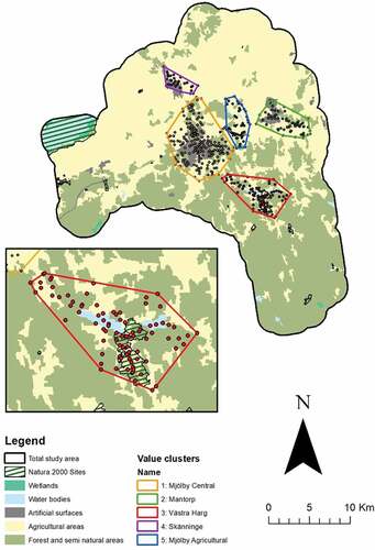
All spatial analyses were performed using ArcMap 10.3.1. Prior to the analysis, we included a two-kilometer buffer zone around the boundary of Mjölby kommun, in order to capture most landscape values, but also exclude spatial outliers (see Brown Citation2006) (). Derived from methods used in Muñoz et al. (Citation2019), we used the Density-Based Clustering DBSCAN algorithm to determine highly value-dense locations in the study site for both levels of self-reported knowledge based on given parameters. We decided that the DBSCAN algorithm was suitable for our research objective as an inductive approach to cluster analysis that automatically finds clusters based on given parameters. Using DBSCAN, we searched for core points, defined as points where a minimum of 10 other points fell within the search radius. Border points were those which fell within the search radius of core points, but which did not have 10 points within their search radius. We determined an appropriate search radius to be 1000 m by using the Near tool to calculate the average Euclidean distance between all value points (i.e. the average nearest distance of one point to another). For each cluster, we then used Monte Carlo simulations to determine significant proportional differences in value assignments between differing levels of knowledge about landscape management.
Finally, we conducted Monte Carlo simulations in order to assess whether land-use types were more likely to affect the assignment of values than self-reported knowledge per density-based cluster. Using the CORINE Land Cover (2018) and the Natura 2000 European Environment Agency (2020) datasets, we were able to observe proportional differences in value assignments based on landscape classes. Because Natura 2000 sites are distinct from and overlap multiple CORINE land cover types, we analyzed the effects of these two land cover classes separately from one another. Additionally, we found that one density cluster featured the Natura 2000 site Västra Harg, prompting closer examination. For this reason, we further tested the relationship between self-reported knowledge and values inside the protected area, and whether certain values were more likely to be assigned inside and outside of Västra Harg.
Results
Socio-demographics and self-reported knowledge: study site
From the 1200 randomly selected invitees, we received 301 responses (25% response rate) and 1276 mapped points representing landscape values. Of the 301 respondents, 27% reported their gender as female and 35% as male. The remaining respondents did not provide an answer. Compared to statistics at the municipal level, a greater proportion of respondents reported as men (50.5%) than women (49.5%) (Statistical Database, Citation2020). No respondents reported their gender as ‘other’. Overall, the self-reported age of survey participants was slightly younger compared with residents in Mjölby kommun, with 14.29% reporting their age as 65 or above in the survey, compared to 27.8% in the municipality (Svensson Citation2019). The median age of respondents was 55; approximately 50% of respondents were between 45 and 65 years of age.
At the time of the survey, 29% of respondents had completed a university-level education, while 31% had not. The remaining 40% did not provide their education level. Individuals were more formally educated at the municipal level, as 75.7% had completed a university-level education, while 22.6% had not (Statistical Database, Citation2020). 42.3% of survey respondents reported to be employed (part-time, full-time or self-employed) compared to 67.4% of the Östergötland population (Statistical Database, Citation2020) (refer to for a description of socio-demographics).
Table 2. Socio-demographics of sample compared to statistics from Mjölby kommun and Östergötland County
Self-reported knowledge about all landscape management sectors was consistently below the median score of 2 out of 4. The highest mean scores in knowledge were reported in native biodiversity (1.97) and climate change (1.87), while the lowest mean scores were reported in wild boar and protected area management (1.68). Some proportional differences in knowledge levels were apparent with regard to gender and age. Women were more likely to report themselves as knowledgeable about forestry (p = 0.016, ASR = 2.4), wild boar management (p = 0.038, ASR = 2.1) and non-native biodiversity (p = 0.019, ASR = 2.3). Respondents aged 65 and older were more likely to be knowledgeable about protected area management, while those age 18–50 were less likely to be knowledgeable about this topic (p = 0.018, ASR = 2.7, 2 respectively). No significant differences in knowledge level appeared in the 51–65 age group. Retired survey respondents were more likely to report themselves as knowledgeable about protected area management. Employment status otherwise had no effect on knowledge about landscape management issues.
Landscape values and self-reported knowledge: study site
Out of 301 respondents, 193 (64.12%) assigned 1,276 landscape value points (average of 6.61). The most frequently assigned values were recreational (24% of total points) and aesthetic (19%). Religious/spiritual (2%) and cultural identity values were the least frequently assigned values (2% and 5%, respectively).
Overall, self-reported knowledge did not significantly correlate with value assignment, but some differences emerged when examining specific areas of knowledge (see supporting material). Those who reported themselves as more knowledgeable about protected area management were more likely to assign religious/spiritual values (p = 0.03, ASR ± 2.2). Those who self-reported more knowledge about non-native biodiversity assigned proportionately more agriculture values (p = 0.002, ASR ±3.1), but contrary to expectations, knowledge about native (p = 0.103) and non-native biodiversity was not significantly related to the assignment of native biodiversity values. Knowledge about wild boar management correlated with the assignment of multiple landscape values; the percentage of harvest (p = 0.01, ASR ± 2.6) and personal identity values (p = 0.044, ASR ± 2) differed significantly between LK and MK participants. Strong proportional differences also emerged in respondents assigning forestry (p = 0.001, ASR ± 3.2) and native biodiversity values (p = 0.003, ASR ± 3).
Landscape values and self-reported knowledge: density clusters
Next, we examined the associations between landscape values and self-reported knowledge within density clusters. Density-based analysis of values returned ten clusters indicating value-dense areas in Mjölby kommun, as well as a group of dispersed points classified as noise unassociated with any cluster. Of the ten clusters, we rejected five for having groups of fewer than 20 points and not including every value type ().
Figure 2. Density-based clusters indicating perimeters of highly value-dense areas in Mjölby kommun. Includes main CORINE land cover classes. Inset map displays Västra Harg cluster, with the Västra Harg Natura 2000 site.
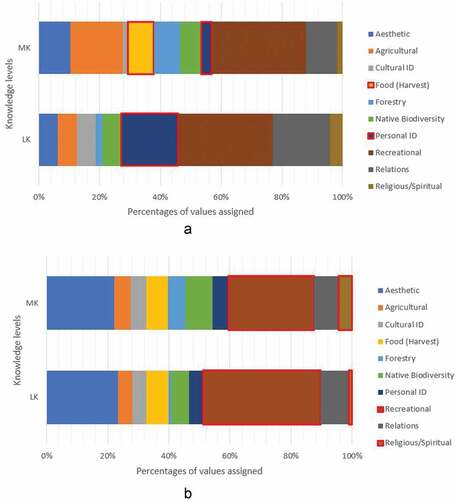
In general, few significant proportional differences appeared between knowledge about land management issues and value assignments in density clusters. While knowledge about wild boar management corresponded with value assignment at the study site level, this had no impact on value assignments in any value cluster. However, in the Mjölby Central cluster, the percentage of religious/spiritual (p = 0.04, ASR = ±2.1) and recreational values (p = 0.04, ASR ± 2.5) differed by knowledge about forestry (). Similarly, we found significant proportional differences in the Västra Harg cluster between those LK and MK about non-native biodiversity and the assignment of harvest values (p = 0.024, ASR ± 2.1), and personal identity values (p = 0.024, ASR ±2.6) (). No significant relationships between level of knowledge and value assignments appeared inside and outside of protected areas in the Västra Harg cluster.
Figure 3. (a) Percentages of values assigned by those more knowledgeable and less knowledgeable about forestry in cluster 1. Values outlined in red indicate significant proportional differences. MK and LK refer to respondents more and less knowledgeable about forestry, respectively. (b) Percentages of values assigned by those more and less knowledgeable about non-native biodiversity in cluster 3. Values outlined in red indicate significant proportional differences. MK and LK refer to respondents more and less knowledgeable about non-native biodiversity, respectively.
Associations between landscape values, self-reported knowledge, and land-use type: density clusters
shows proportional differences in land-use types in each density cluster. We found that the study site was represented predominantly by agricultural area, but the Mjölby Central and Västra Harg clusters under and over-represented agricultural land, respectively. Additionally, forest and semi-natural areas and Natura 2000 sites were over-represented in cluster 3, which includes almost the entire Natura 2000 site Västra Harg. While Mjölby kommun’s proportion of artificial surfaces is relatively small (1.53%), clusters Mjölby Central, Mantorp, and Skänninge include built areas that increased their share of artificial surfaces.
Table 3. Area calculations of landscape use types in each density-based cluster. All areas are in hectares (ha). The largest land-use types are indicated in bold
Overall, our Monte Carlo simulations suggest that land-use types were a more significant indicator of the values assigned in each cluster compared with self-reported knowledge. In the Mjölby Central cluster, recreational values, the most frequently assigned value type in the survey, were more likely to be found in forest and semi-natural areas (p < 0.001, ASR 3.96) (). Personal identity values tended to occur in specific clusters and land-use types. In the Mjölby Central cluster, personal identity values were more likely to occur in agricultural areas (p < 0.001, ASR = 2.5), despite this land-use types being underrepresented in the cluster (). Conversely, personal identity values were negatively associated with forest and semi-natural areas (p < 0.001, ASR = −2.54). When examining under-represented value types, we found that cultural identity values were more likely to be assigned to artificial surfaces in the Mjölby Central cluster (p < 0.001, ASR = 3.34) and were less likely to be assigned to its forest and semi-natural areas (p < 0.001, ASR = −2.9).
Figure 4. (a) Landscape values assigned to landscape uses in the Mjölby Central density cluster. (b) Landscape values assigned to landscape uses in the Mantorp density cluster. (c) Landscape values assigned to landscape uses in the Västra Harg density cluster. (d) Landscape values assigned to landscape uses in the Skänninge density cluster. Concentric circles represent the ASR, for which significant results are defined at ± 2. Positive associations are indicated in green, moving to negative associations in red towards the center.
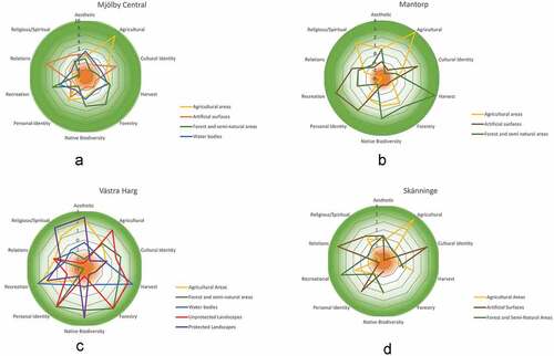
In the Mantorp cluster, recreational values were more strongly associated with artificial surfaces (p < 0.001, ASR = 2.83) (). As in the Mjölby Central cluster, personal identity values were also negatively associated with forest and semi-natural areas (p < 0.001, ASR = −2.1). Religious/spiritual values, the least represented value type, were more likely to be assigned to this cluster’s agricultural areas (p < 0.001, ASR = 2.35).
In the Västra Harg cluster, recreational values were negatively associated with forest and semi-natural areas (p = 0.016, ASR = −2.93) but positively associated with waterbodies (p = 0.001, ASR = 2.14) (). Aesthetic values were the second most frequently assigned value type. These values were most relevant in the Västra Harg cluster and were more likely to be assigned to agricultural areas (p = 0.016, ASR = 2.1), despite this land-use type being under-represented in the cluster (). Aesthetic values were also more likely to be assigned inside the Västra Harg Natura 2000 site (p = 0.001, ASR 2.4). Here, personal identity values were assigned to unprotected areas (p < 0.001, ASR = 2). Notably, religious/spiritual values were positively associated with protected landscapes in the Västra Harg cluster (p = 0.016, ASR = 2.3).
Similar to the Mjölby Central cluster, recreational values were also positively associated with forest and semi-natural areas in the Skänninge cluster (p < 0.001, ASR 2.63) (). Here, under-represented cultural identity values were also more associated with artificial surfaces (p < 0.001, ASR = 2.8) and negatively associated with its agricultural areas (p < 0.001, ASR = −2.13).
An obvious degree of consistency between landscape values and land-use types was evident in some cases. For example, agricultural values were frequently strongly associated with agricultural land-use types, and forestry values with forestry land-use types. For this reason, we excluded these results from analysis. Finally, the Mjölby agricultural cluster did not return significant results on the relationship between land-use and values.
Discussion
Overall, we found stronger spatial associations between landscape values and land-use types compared with landscape values and self-reported knowledge about landscape management. The land-use type to which a landscape value is assigned is sometimes supported by self-reported knowledge, while self-reported knowledge did not provide a conclusive pattern about value assignment on its own. Given these differences, we propose that a more holistic understanding of local knowledge and landscape value assignment is needed, accounting for self-reported knowledge about landscape management issues, in addition to more classical PGGIS studies focusing on the relationships between landscape values, land-use type and general familiarity with a study region.
Here, we identify three main intersections between landscape values and the forms of local knowledge in this study: 1) value types over-represented in PPGIS research with strong links to land-use; 2) value types under-represented in PPGIS research with strong links to land-use; 3) value types under-represented in PPGIS research grounded in both land-use and self-reported knowledge. While certain landscape values may be under-represented in PPGIS research, spatial variations in their assignment linked to self-reported knowledge can help derive motivations about landscape values among diverse groups.
Over-represented values and land-use
We found that the frequent assignment of recreational and aesthetic values was largely unaffected by self-reported knowledge. We propose this could be because these values are not generally derived from formalized, explicit knowledge but are often more tacit or implicit in scope (following Raymond et al. Citation2010). Knowledge about landscape management can be technical and abstracted from context and therefore may have less impact upon aesthetic and recreational value assignment. Recreational and aesthetic values were the most frequently assigned to the landscape at 43% of the total values mapped, an important pattern that aligns with many past value-mapping studies using PPGIS methods (Brown and Brabyn Citation2012; Muñoz et al. Citation2019; Munro et al. Citation2017; Plieninger et al. Citation2018; Sherrouse et al. Citation2014; van Riper et al. Citation2012).
Under-represented values and land-use
In this research, we allowed participants to identify and map personal and cultural identity values using pre-determined operational definitions. Spatial patterns of these values highlighted perceptions of how the collective and individual identities of Mjölby kommun’s residents are shaped by the landscape. In this study, cultural identity values often linked to artificial surfaces in density clusters and significantly disconnected from forested and semi-natural and agricultural areas. Cultural identity values also had no significant connection to knowledge about landscape management. These results contribute to a pattern of tacit values that are more likely to be grounded in land-use than self-reported knowledge and aligns with previous work indicating that cultural identity helps to surface place-based meaning (Davenport and Anderson Citation2005). However, the decreased frequency of cultural value assignment (5% of the total values mapped) illustrates that individualized PPGIS mapping may not be the best method for assessing community-wide cultural values. Cultural identity values may instead be developed through social interaction, a factor not considered with PPGIS research conducted with individuals (Kenter et al. Citation2016).
Under-represented values across both land-use and self-reported knowledge
Interesting distinctions appeared when considering both land-use and self-reported knowledge with the assignment of personal identity and religious/spiritual values, the least frequently mapped values at 9% of the total values assigned. With regard to personal identity values, we saw that these were associated with certain agricultural landscapes and dissociated from forested and semi-natural landscapes and protected areas. In parallel, MK respondents about wild boar management were more likely to assign personal identity values at the study site level (these MK respondents were also more likely to assign native biodiversity, harvest, and forestry values). Knowledge about wild boar management was less important at the density cluster level. This interesting result could stem from the fact that wild boars are mobile in the landscape and effect high levels of impact across land-use types (Campbell and Long Citation2009; Gren et al. Citation2020). These respondents may also have livelihoods and lifestyles, and thus personal identity, linked to the agricultural landscapes at stake in the management of wild boars, a view supported by past research indicating farmers are more likely to have negative views towards wild boars (Harper et al. Citation2016).
Meanwhile, religious/spiritual values were more likely to be assigned to the Västra Harg Natura 2000 site and certain agricultural areas, corroborating previous research indicating similar patterns (Raymond and Brown Citation2006; Zoderer et al. Citation2016). Greater knowledge about protected area management also reflected a greater likelihood to assign religious/spiritual values at the study site level. This result is consistent with past work on social values of users and practitioners of protected areas, who identify protected areas with intangible experiences related to tranquility and the opportunity to escape modern life (Pike et al. Citation2011).
Limitations and future directions
A limitation of this study was the left skew to self-reported knowledge, meaning most respondents reported weak to moderate knowledge about natural resource management issues. This may be partly due to cultural reasons but was also partly a result of our sampling strategy, as we focused on randomly sampling residents who may not be tied to landscape management sectors. This was evident from our results, which indicated that residents were more knowledgeable about topics in native biodiversity and climate change, than, for example, wild boar and protected area management. However, knowledge is not evenly distributed. This is emphasized, for example, by the growing rural–urban divide through the development of the knowledge economy (Li et al. Citation2019) and gendered access to ‘knowledge required for agency’ in Sweden (Ledman et al. Citation2018, p. 98). While this sampling decision was most appropriate for this study based on available resources, we recommend that future PPGIS studies intending to examine these forms of knowledge use a random stratified sampling technique in which respondents are grouped based on known levels of self-reported knowledge. Additionally, representativeness was complicated by decreased response rate to socio-demographic questions. For these reasons, it is difficult to extrapolate the study data to the wider population of Mjölby kommun; however, it is still possible to observe patterns through the data provided and look for avenues for future PPGIS research in self-reported knowledge and values.
Implications for integrated landscape management
Integrated landscape management policy increasingly draws upon local and scientific knowledge. Protected area management plans also benefit through recognizing the importance of diverse knowledges and hence diverse values (Pike et al. Citation2011). This is particularly important for multifunctional landscapes such as Västra Harg in our study, which is a mosaic landscape defined by more or less conspicuous edges and boundaries that simultaneously separate and connect different land uses, interests, conservation goals, and human activities. This study can help landscape managers tailor their strategies to integrate the discrete associations between landscape values and land-uses and the type and level of local knowledge about landscape management. We found significant associations of self-reported knowledge with age and some value types, which can inform management not only on which values are important for whom and where, but also what are potential areas of concern. For example, there was generally low societal knowledge about landscape management practices in the area, and a particular lack of knowledge on protected area management among the younger population. Thus, educational materials, exhibitions and training workshops could be used to further promote learning and sense of community. Future research could then investigate if an increase in knowledge about local landscape management would more strongly influence value assignment and pro-environmental behavior (Fielding and Head Citation2012; Otto and Pensini Citation2017).
Conclusion
This study examined the relationships between landscape values, self-reported knowledge about landscape management, and land-use types. Overall, our results corroborate past research suggesting that there are strong links between landscape values and land-use (Brown and Fagerholm Citation2015). For example, we found strong associations between tacitly understood values and land-use, particularly for recreational and aesthetic values. However, other landscape values under-represented in this study and others in the PPGIS literature (cultural identity, personal identity, and religious/spiritual values) also had strong associations to self-reported knowledge about landscape management. Therefore, the potential for diversity in knowledge should be accounted for in integrated landscape management planning. Communities as a whole could benefit from this approach in the future. For example, landscape managers may target educational material for residents, thereby promoting community learning, while also engaging with more diverse landscape values. We recommend testing these methods in other case study sites where knowledge dynamics can be further examined and untangled in order to better understand these context-specific relationships.
Supplementar Material
Download PDF (412.2 KB)Acknowledgments
ENVISION was funded through the 2017–2018 Belmont Forum and BiodivERsA joint call for research proposals, under the BiodivScen ERA-Net COFUND programme, and with the support of the following national funders: Swedish Research Council for Sustainable Development (FORMAS), Federal Ministry of Education and Research, Germany, Netherlands Organisation for Scientific Research (NWO), National Science Foundation, United States (NSF), National Park Service, United States (NPS) and the Ministerio de Ciencia e Innovación, Spain.
AIHM acknowledges funding through the European Union’s Horizon 2020 research and innovation programme under the Marie Sklodowska‐Curie Actions, grant agreement number H2020-MSCA-IF-2018-840207. Open access funded by Helsinki University Library.
Supplementary material
Supplemental data for this article can be accessed here.
Disclosure statement
No potential conflict of interest was reported by the author(s).
Additional information
Funding
References
- Arias-Arévalo P, Martín-López B, Gómez-Baggethun E. 2017. Exploring intrinsic, instrumental, and relational values for sustainable management of social-ecological systems. Ecol Soc. 22:art43. doi:10.5751/ES-09812-220443.
- Brown G. 2004. Mapping spatial attributes in survey research for natural resource management: methods and applications. Soc Nat Resour. 18:17–39. doi:10.1080/08941920590881853.
- Brown G. 2006. Mapping landscape values and development preferences: a method for tourism and residential development planning. Int J Tourism Res. 8:101–113. doi:10.1002/jtr.562.
- Brown G. 2012. Public participation GIS (PPGIS) for regional and environmental planning: reflections on a decade of empirical research. J Urban Reg Inf Syst Inf Assoc. 25:12.
- Brown G. 2013. The relationship between social values for ecosystem services and global land cover: an empirical analysis. Ecosyst Serv. 5:58–68. doi:10.1016/j.ecoser.2013.06.004.
- Brown G. 2015. Engaging the wisdom of crowds and public judgement for land use planning using public participation geographic information systems. Aust Planner. 52:199–209. doi:10.1080/07293682.2015.1034147.
- Brown G, Brabyn L. 2012. An analysis of the relationships between multiple values and physical landscapes at a regional scale using public participation GIS and landscape character classification. Landsc Urban Plan. 107:317–331. doi:10.1016/j.landurbplan.2012.06.007.
- Brown G, Fagerholm N. 2015. Empirical PPGIS/PGIS mapping of ecosystem services: a review and evaluation. Ecosyst Serv. 13:119–133. doi:10.1016/j.ecoser.2014.10.007.
- Brown G, Kyttä M. 2014. Key issues and research priorities for public participation GIS (PPGIS): a synthesis based on empirical research. Appl Geogr. 46:122–136. doi:10.1016/j.apgeog.2013.11.004.
- Brown G, Reed P. 2009. Public participation GIS: a new method for use in national forest planning. For Sci. 55:166–182. doi:10.1093/forestscience/55.2.166.
- Brown G, Sanders S, Reed P. 2018. Using public participatory mapping to inform general land use planning and zoning. Landsc Urban Plan. 177:64–74. doi:10.1016/j.landurbplan.2018.04.011.
- Brown G, Weber D, Zanon D, de Bie K. 2012. Evaluation of an online (opt-in) panel for public participation geographic information systems surveys. Int J Public Opin Res. 24:534–545. doi:10.1093/ijpor/eds001.
- Campbell TA, Long DB. 2009. Feral swine damage and damage management in forested ecosystems. For Ecol Manage. 257:2319–2326. doi:10.1016/j.foreco.2009.03.036.
- Chan KMA, Balvanera P, Benessaiah K, Chapman M, Díaz S, Gómez-Baggethun E, Gould R, Hannahs N, Jax K, Klain S et al. 2016. Why protect nature? Rethinking values and the environment. Proc. Natl. Acad. Sci. 113:1462–1465. https://doi.org/10.1073/pnas.1525002113
- CLC. 2018. 2018 — Copernicus land monitoring service [WWW Document]. Copernicus. accessed 2020 Oct 12. https://land.copernicus.eu/pan-european/corine-land-cover/clc2018.
- Davenport MA, Anderson DH. 2005. Getting from sense of place to place-based management: an interpretive investigation of place meanings and perceptions of landscape change. Soc Nat Resour. 18:625–641. doi:10.1080/08941920590959613.
- Díaz S, Demissew S, Carabias J, Joly C, Lonsdale M, Ash N, Larigauderie A, Adhikari JR, Arico S, Báldi A, et al. 2015. The IPBES conceptual framework — connecting nature and people. Curr Opin Environ Sustainability Open Issue. 14:1–16. doi:10.1016/j.cosust.2014.11.002.
- Díaz S, Pascual U, Stenseke M, Martín-López B, Watson RT, Molnár Z, Hill R, Chan KMA, Baste IA, Brauman KA, et al. 2018. Assessing nature’s contributions to people. Science. 359:270–272. doi:10.1126/science.aap8826.
- Drews S, van den Bergh JCJM. 2016. Public views on economic growth, the environment and prosperity: results of a questionnaire survey. Global Environ Change. 39:1–14. doi:10.1016/j.gloenvcha.2016.04.001.
- Engen S, Runge C, Brown G, Fauchald P, Nilsen L, Hausner V. 2018. Assessing local acceptance of protected area management using public participation GIS (PPGIS). J Nat Conserv. 43:27–34. doi:10.1016/j.jnc.2017.12.002.
- Fagerholm N, Käyhkö N, Ndumbaro F, Khamis M. 2012. Community stakeholders’ knowledge in landscape assessments – mapping indicators for landscape services. Ecol Indic. 18:421–433. doi:10.1016/j.ecolind.2011.12.004.
- Fazey I, Moug P, Allen S, Beckmann K, Blackwood D, Bonaventura M, Burnett K, Danson M, Falconer R, Gagnon AS, et al. 2018. Transformation in a changing climate: a research agenda. Clim Dev. 10:197–217. doi:10.1080/17565529.2017.1301864.
- Fazey I, Schäpke N, Caniglia G, Hodgson A, Kendrick I, Lyon C, Page G, Patterson J, Riedy C, Strasser T, et al. 2020. Transforming knowledge systems for life on earth: visions of future systems and how to get there. Energy Res Soc Sci. 70:101724. doi:10.1016/j.erss.2020.101724.
- Fielding KS, Head BW. 2012. Determinants of young Australians’ environmental actions: the role of responsibility attributions, locus of control, knowledge and attitudes. Environ Educ Res. 18:171–186. doi:10.1080/13504622.2011.592936.
- Garrido P, Elbakidze M, Angelstam P. 2017. Stakeholders’ perceptions on ecosystem services in Östergötland’s (Sweden) threatened oak wood-pasture landscapes. Landsc Urban Plan. 158:96–104. doi:10.1016/j.landurbplan.2016.08.018.
- Gifford R, Nilsson A. 2014. Personal and social factors that influence pro-environmental concern and behaviour: a review. Int J Psychol. 49:141–157. doi:10.1002/ijop.12034.
- Gren I-M, Andersson H, Mensah J, Pettersson T. 2020. Cost of wild boar to farmers in Sweden. Eur Rev Agric Econ. 47:226–246. doi:10.1093/erae/jbz016.
- Hakkarainen V, Anderson CB, Eriksson M, van Riper CJ, Horcea-Milcu A, Raymond CM. 2020. Grounding IPBES experts’ views on the multiple values of nature in epistemology, knowledge and collaborative science. Environ Sci Policy. 105:11–18. doi:10.1016/j.envsci.2019.12.003.
- Harper EE, Miller CA, Vaske JJ, Mengak MT, Bruno S. 2016. Stakeholder attitudes and beliefs toward wild pigs in Georgia and Illinois. Wildl Soc Bull. 40:269–273. doi:10.1002/wsb.653.
- Hill R, Adem Ç, Alangui WV, Molnár Z, Aumeeruddy-Thomas Y, Bridgewater P, Tengö M, Thaman R, Adou Yao CY, Berkes F, et al. 2020. Working with Indigenous, local and scientific knowledge in assessments of nature and nature’s linkages with people. Curr Opin Environ Sustainability. 43:8–20. doi:10.1016/j.cosust.2019.12.006.
- Kearney AR, Bradley GA. 2011. The effects of viewer attributes on preference for forest scenes: contributions of attitudes, knowledge, demographic factors, and stakeholder group membership. Environ Behav. 43:147–181. doi:10.1177/0013916509353523.
- Kenter JO, Reed MS, Fazey I. 2016. The deliberative value formation model. Ecosyst Serv Shared Plural Cult Values. 21:194–207. doi:10.1016/j.ecoser.2016.09.015.
- Ledman K, Rosvall P-Å, Nylund M. 2018. Gendered distribution of ‘knowledge required for empowerment’ in Swedish vocational education curricula? J Vocational Educ Training. 70:85–106. doi:10.1080/13636820.2017.1394358.
- Li Y, Westlund H, Liu Y. 2019. Why some rural areas decline while some others not: an overview of rural evolution in the world. J Rural Stud. 68:135–143. doi:10.1016/j.jrurstud.2019.03.003.
- Muñoz L, Hausner V, Brown G, Runge C, Fauchald P. 2019. Identifying spatial overlap in the values of locals, domestic- and international tourists to protected areas. Tourism Manage. 71:259–271. doi:10.1016/j.tourman.2018.07.015.
- Munro JK, Moore SA. 2005. Using landholder perspectives to evaluate and improve recovery planning for Toolibin Lake in the West Australian wheatbelt. Ecol Manage Restor. 6:111–117. doi:10.1111/j.1442-8903.2005.00227.x.
- Munro J, Pearce J, Brown G, Kobryn H, Moore SA. 2017. Identifying ‘public values’ for marine and coastal planning: are residents and non-residents really so different? Ocean Coast Manage. 148:9–21. doi:10.1016/j.ocecoaman.2017.07.016.
- Natura 2000 data- the European network of protected sites [WWW Document]. 2020. European Environment Agency. accessed 2020 Oct 12. https://www.eea.europa.eu/data-and-maps/data/natura-11.
- Otto S, Pensini P. 2017. Nature-based environmental education of children: environmental knowledge and connectedness to nature, together, are related to ecological behaviour. Global Environ Change. 47:88–94. doi:10.1016/j.gloenvcha.2017.09.009.
- Pannell DJ, Marshall GR, Barr N, Curtis A, Vanclay F, Wilkinson R. 2006. Understanding and promoting adoption of conservation practices by rural landholders. Aust J Exp Agric. 46:1407–1424. doi:10.1071/EA05037.
- Pereira LM, Karpouzoglou T, Frantzeskaki N, Olsson P. 2018. Designing transformative spaces for sustainability in social-ecological systems. Ecol Soc. 23:art32. doi:10.5751/ES-10607-230432.
- Pike K, Johnson D, Fletcher S, Wright P. 2011. Seeking spirituality: respecting the social value of coastal recreational resources in England and Wales. J Coast Res. 61:194–204. doi:10.2112/SI61-001.14.
- Plieninger T, Rana HÁA, Fagerholm N, Ellingsgaard GF, Magnussen E, Raymond CM, Olafsson AS, Verbrugge LNH. 2018. Identifying and assessing the potential for conflict between landscape values and development preferences on the Faroe Islands. Global Environ Change. 52:162–180. doi:10.1016/j.gloenvcha.2018.07.006.
- Raymond C, Brown G. 2006. A method for assessing protected area allocations using a typology of landscape values. J Environ Plann Manage. 49:797–812. doi:10.1080/09640560600945331.
- Raymond C, Brown G. 2007. A spatial method for assessing resident and visitor attitudes towards tourism growth and development. J Sustainable Tourism. 15:520–540. doi:10.2167/jost681.0.
- Raymond CM, Bryan BA, MacDonald DH, Cast A, Strathearn S, Grandgirard A, Kalivas T. 2009. Mapping community values for natural capital and ecosystem services. Ecol Econ. 68:1301–1315. doi:10.1016/j.ecolecon.2008.12.006.
- Raymond CM, Fazey I, Reed MS, Stringer LC, Robinson GM, Evely AC. 2010. Integrating local and scientific knowledge for environmental management. J Environ Manage. 91:1766–1777. doi:10.1016/j.jenvman.2010.03.023.
- Sherrouse BC, Semmens DJ, Clement JM. 2014. An application of Social Values for Ecosystem Services (SolVES) to three national forests in Colorado and Wyoming. Ecol Indic. 36:68–79. doi:10.1016/j.ecolind.2013.07.008.
- Statistical database [WWW Document]. 2020. SCB. accessed 2020 Dec 15. https://www.statistikdatabasen.scb.se/pxweb/en/ssd/START__UF__UF0506/.
- Stenseke M. 2016. Integrated landscape management and the complicating issue of temporality. Landscape Res. 41:199–211. doi:10.1080/01426397.2015.1135316.
- Stoutenborough JW, Vedlitz A. 2014. The effect of perceived and assessed knowledge of climate change on public policy concerns: an empirical comparison. Environ Sci Policy. 37:23–33. doi:10.1016/j.envsci.2013.08.002.
- Svensson A. 2019. Befolkningsstatistik [WWW Document]. Mjölby. accessed 2020 Dec 15. https://www.mjolby.se/34988.html.
- Sverige N. 2013. Sweden’s environmental objectives: an introduction. Stockholm: Swedish Environmental Protection Agency.
- Tengö M, Hill R, Malmer P, Raymond CM, Spierenburg M, Danielsen F, Elmqvist T, Folke C. 2017. Weaving knowledge systems in IPBES, CBD and beyond—lessons learned for sustainability. Curr Opin Environ Sustainability Open Issue Part II. 26–27:17–25. doi:10.1016/j.cosust.2016.12.005.
- Torralba M, Fagerholm N, Hartel T, Moreno G, Plieninger T. 2018. A social-ecological analysis of ecosystem services supply and trade-offs in European wood-pastures. Sci Adv. 4:eaar2176. doi:10.1126/sciadv.aar2176.
- van Riper CJ, Foelske L, Kuwayama SD, Keller R, Johnson D. 2020. Understanding the role of local knowledge in the spatial dynamics of social values expressed by stakeholders. Appl Geogr. 123:102279. doi:10.1016/j.apgeog.2020.102279.
- van Riper CJ, Kyle GT, Sherrouse BC, Bagstad KJ, Sutton SG. 2017. Toward an integrated understanding of perceived biodiversity values and environmental conditions in a national park. Ecol Indic. 72:278–287. doi:10.1016/j.ecolind.2016.07.029.
- van Riper CJ, Kyle GT, Sutton SG, Barnes M, Sherrouse BC. 2012. Mapping outdoor recreationists’ perceived social values for ecosystem services at Hinchinbrook Island National Park, Australia. Appl Geogr. 35:164–173. doi:10.1016/j.apgeog.2012.06.008.
- Varghese J, Crawford SS. 2020. A cultural framework for Indigenous, Local, and Science knowledge systems in ecology and natural resource management. Ecol Monogr. e01431. doi:10.1002/ecm.1431.
- Vulturius G, André K, Swartling ÅG, Brown C, Rounsevell M. 2020. Successes and shortcomings of climate change communication: insights from a longitudinal analysis of Swedish Forest owners. J Environ Plann Manage. 63:1177–1195. doi:10.1080/09640568.2019.1646228.
- West S, Haider LJ, Stålhammar S, Woroniecki S. 2020. A relational turn for sustainability science? Relational thinking, leverage points and transformations. Ecosyst People. 16:304–325. doi:10.1080/26395916.2020.1814417.
- Zafra-Calvo N, Balvanera P, Pascual U, Merçon J, Martín-López B, van Noordwijk M, Mwampamba TH, Lele S, Ifejika Speranza C, Arias-Arévalo P, et al. 2020. Plural valuation of nature for equity and sustainability: insights from the Global South. Global Environ Change. 63:102115. doi:10.1016/j.gloenvcha.2020.102115.
- Zoderer BM, Tasser E, Erb K-H, Lupo Stanghellini PS, Tappeiner U. 2016. Identifying and mapping the tourists’ perception of cultural ecosystem services: a case study from an Alpine region. Land Use Policy. 56:251–261. doi:10.1016/j.landusepol.2016.05.004.