Abstract
This paper will outline the development and continual enhancement of a suite of field-orientated problem-based exercises with associated suitable field sites for the applied geoscience courses at the University of Portsmouth. The two principal degree pathways considered are BEng Engineering Geology and Geotechnics and BSc Geological Hazards. Some of the material developed is being enhanced further for use on the MSc Geohazard Assessment and MSc Engineering Geology programmes.
These exercises developed include innovations in the learning, teaching and assessment of the field-based skills required of a modern applied geoscientist. The key aspects of student engagement, lateral thinking skills and resource use are developed within these field-based programmes and associated scenario-based exercises.
Introduction
Geology and Applied Geology are principally field-based disciplines. For undergraduate students the ‘field’ could be considered as their most significant learning environment.
For over 40 years staff in the now School of Earth and Environmental Sciences at Portsmouth have developed and led fieldwork programmes, yet despite this long experience very little work has been undertaken in the research and learning development of this work outside of the actual trips themselves. All such development has usually been undertaken during the ‘live’ field visits with the undergraduates. Very little time was available in the field for the reconnaissance of new potentially more suitable sites for the exercises. Over this period the field-based learning has progressed from simple ‘lectures in the field’ to more sophisticated student-orientated exercises that have been designed to develop more individual skills such as self-reliance; the ability to work in teams; and the ability to organise, manage and report a field-based programme of investigation, all based around a variety of geological settings and applied geoscience problems.
Increasingly, we are using problem-based exercises to develop these key skills that are required of a geoscientist such as engineering geologists and geological hazard specialists graduating from the School. A portfolio of such exercises is now available in its initial form. This is undergoing further development and research to engage the participating students, to further refine these innovations in learning, teaching and particularly assessment in this field-based environment.
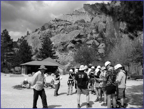
The current Applied Geoscience fieldwork programme at Portsmouth is a major element of the degree pathways and comprises some 75 to 80 days spread over the three years of the courses. The emphasis in the first two years is strongly towards providing the observational, recording, synthesising and problem-solving skills required of a modern applied geologist. Areas such as the Isle of Wight, Dorset, North Devon and Kent are currently visited in the UK, with overseas trips to various regions of France and Spain.
The courses culminate in a study tour of geological hazard and engineering geological sites (currently in France) that integrate the various strands of the pathways and provide an overview of the diversity of geological hazards and engineering geological problems in the natural world.
Level 1 Applied Geoscience Programme
The Level 1 field programme is principally concerned with introducing students to basic field geology and no previous geological experience or knowledge is assumed.
At the end of the year, the students embark on their major field course for the session, which is an extended trip, developing further field geology and introducing basic geological mapping techniques. Currently this work is undertaken in the Sierra Norte Mountains close to Madrid. This more exotic location, compared, for example, to the more conventional sites such as the Lake District, acts as a major incentive for students throughout their first year at the university.
Table 1 Locations and activities undertaken for the Level 1 Applied Geoscience fieldwork programme.
Level 2 Applied Geoscience Programme
The Level 2 field programme is primarily a series of techniques-based trips where the fundamental applied geoscience field skills are developed.
These skills include Quaternary sediments logging, geomorphological mapping, rock mass assessment, discontinuity surveys and thematic geohazard assessments.
Level 3 Applied Geoscience Programme
At Level 3 more specialised fieldwork is undertaken with the focus on the integration of the applied geoscientific skills developed within the Level 2 programme.
Table 2 Locations and activities undertaken for the Level 2 Applied Geoscience fieldwork programme.
Table 3 Locations and activities undertaken for the Level 3 Applied Geoscience fieldwork programme.
Problem-based Exercises
Increasingly, the focus of these fieldwork programmes has been to introduce specific ‘problems’ associated with the area visited that applied geoscientists might need to solve. These problems could be real, for example, a by-pass for the Cotswolds village of Broadway, or they could be hypothetical, such as a deep level nuclear waste repository for the Malvern Hills. outlines the current portfolio of these ‘real world’ exercises and Box 1 gives an example of the problem set for the Villerville exercise. Increasingly, the field-based activities are being supplemented with pre and post workshops at the University in Portsmouth.
Table 4 Some examples of the current portfolio of problem-based exercises in the applied geosciences.
Box 1 Example of a Problem Based-Exercise in Villerville, Normandy
Geomorphological terrain evaluation and hazard assessment of the Villerville-Cricqueboeuf region, Normandy, France.
Location
This investigation will concentrate on a section of the Calvados coast in Normandy, France, between the towns of Villerville and Hennequeville, an area that has been repeatedly affected by landslides. The site is of particular interest following a particularly intense rainstorm, which produced a sequence of slope failures and the presence of a large-scale coastal landslide complex, which has resulted in the total or partial destruction of local buildings and road infrastructure.
Scope of the investigation
Following an intense rainstorm in May 2003, several towns on the Normandy coast experienced severe flooding and a number of landslides occurred in the Villerville region, resulting in significant damage to local infrastructure and housing. The problems have been further compounded by the presence of a series of active coastal landslide complexes in the region.
As a result, Portsmouth Geomorphological Services has been commissioned to undertake a rapid terrain evaluation and hazard assessment of the coastal area between Villerville and Hennequeville, and produce a series of maps and short reports for the local planning team. As part of this investigation, you will work in teams of four and undertake a rapid reconnaissance of the area over three days to collect field information from which a hazard and risk assessment will be produced.
Student Feedback
As part of the evaluation and review of the developed field programmes, students were asked to provide more ‘colloquial’ feedback than would normally be provided via the University’s formal unit-based feedback system. While away on the trips, they were asked to complete a series of daily fieldwork logs or ‘Flogs’ (aka Blogs!) containing the following:
What I enjoyed and thought was good about the field day
What I didn’t enjoy about the field day
How I would improve the field day if I was running the course
The returns were generally much higher than with the more formal system. Generally, the comments were positive and, interestingly, virtually no students commented on how to improve the various trips. They very much enjoyed the group and problem-based work, commenting that it was good to experience and put into practice what they had learnt in the campus based lecture programme. Apart from the usual complaints about the weather, the hotel food and, surprisingly, some concerns about being cut off by the tide, and staff minibus driving, the main issue raised were about trip preparation. Many students felt that a more formal classroom briefing would have been helpful, together with some preparatory reading and references. Several of the field courses have pre-reading lists, but not all. None of the fieldwork has an explicit technical briefing session before arrival in the field area. Once in the field, the students very much liked being left to organise themselves and get on with the problem-based tasks. They enjoyed the teamwork and dealing with real problems. They liked ‘working it out for themselves’ with appropriate support from the staff. The main skills issues that they brought up were concerning some basic map reading problems, dealing with the more systematic and perhaps tedious tasks, such as logging and understanding the difference between concave and convex when geomorphological mapping!
Plate 1 Students developing a series of applied geoscience skills in the Malvern Hills. Rock mass assessment, discontinuity surveys and scan lines together with some basic field surveying techniques are taught.
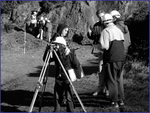
Plate 2 The seismic forensic exercise at the Claps du Luc landslide, Drome, France.
Conclusions
Applied geoscience fieldwork lends itself well to problem-based exercises. The students greatly enjoy the scenarios that are set and benefit from the team-based approach to solving the various problems. The field remains the key learning environment for geoscience and should be considered as their most significant learning environment, where the integration of all of the major learning skills can be integrated in an interesting and innovative manner.
Acknowledgements
This project has been part funded by the GEES Subject Centre Small-Scale Project Funding Scheme ‘Bringing the Real World into the GEES Student Learning Experience’.