Abstract
Google Earth is a web-based virtual globe, launched in 2005, that offers significant potential as a teaching tool and a learning resource for undergraduate geography, earth and environmental science students, as well as other disciplines. In 2008, 56 undergraduate geography students were surveyed regarding their prior use of Google Earth to inform the delivery of classes that used Google Earth. Surprisingly, 25% of students had not previously used Google Earth and, amongst those that had, only 23% had used it in academic study, and only 11% had used it in a taught class. Differences between first and final year students were evident, with 40% of first year, but only 18% of final year, students having used Google Earth previously for academic study, possibly reflecting time since the launch, and the differential use of Google Earth in schools, colleges and university. Although the situation is likely to change rapidly, tutors may not assume all students have used Google Earth prior to university, and those that have may not have used it in academic study, and even less likely in a taught class.
Introduction
Google Earth is a freely available software package that may be downloaded from the Internet and provides satellite images and Geographic Information System (GIS) functions that are relatively easy to use. Academic research that employs Google Earth spans a number of disciplines. Geography, earth and environmental science subjects would perhaps be expected to make use of the technology in a range of landscape and environmental research projects (e.g. CitationNourbakhsh et al., 2006; McCaffrey et al., 2008; Thorndycraft and Thompson, 2008), however, health (e.g. CitationBoulos, 2005; Sundvall et al., 2007; Lefer et al., 2008; Kamadjeu, 2009), planning (CitationBall et al., 2007), tourism (e.g. CitationCao et al., 2006), water technology (CitationImberger et al., 2006), biodiversity (e.g. CitationKatsarapong et al., 2007), archaeology (e.g. CitationParcak, 2007) and urban development (e.g. CitationPugnaloni et al., 2007; Monkkonen, 2008) are also using the technology successfully.
Google Earth launched its Outreach programme in 2007, however, its use in Higher Education (HE) as a learning and teaching resource has not been extensively documented in the literature, although initiatives at secondary school level are beginning to be discussed (e.g. CitationPatterson, 2007; Buchanan-Dunlop, 2008; Schultz et al., 2008). A survey of literature conducted by the author, using the ISI Web of Knowledge database (conducted 30th March 2009), indicated that only 38 published articles (journal and conference papers) contain “Google Earth” in the title and 123 identified “Google Earth” as a topic. This apparent slow take up of the technology at the HE level is one of the stimuli for this research. In contrast, the use of Google Earth in business and industry is beginning to gather pace (CitationForesman, 2008). Indeed, the Google Earth website highlights the growing application of the technology to industry and business, with relevance to employment areas in commercial and residential real estate, architecture and engineering, insurance, media, public and NGO’s, national and local government, and defence, security and intelligence.
The current project is funded by the Higher Education Academy Subject Centre for Geography, Earth and Environmental Sciences (HEA-GEES) and is particularly examining the use of Google Earth in sustainable development education. However, potential exists to use Google Earth more broadly in blended learning (CitationDavis and Fill, 2007), or in conventional classroom, laboratory and field settings, whether in supervised groups or self-directed across University curricula. It has application in almost any subject area studied at HE Institutions and so should have broad relevance. Also, it clearly has the potential to support student outreach programmes and off-campus activities, such as expeditions and voluntary placements (e.g. CitationWinlow, Simm and Haslett, 2007). It is hoped that this research will help to promote Google Earth in the University portfolio of online learning resources in the UK and abroad.
One of the challenges of using any technology in student learning is the provision of appropriate training in its use. For this study, a small-scale survey was undertaken in order to ascertain prior student experience of using Google Earth, and the context of that use, the results of which could then be used to inform the training provided and the way tutors approach the use of Google Earth in their teaching. The aim of this paper is to report and discuss the results of that survey.
Methods
Two groups of students, studying undergraduate geography modules, were surveyed in the Department of Geography at Bath Spa University in Semester 2 of academic year 2007–2008. Group A comprised first year (Certificate-level) undergraduates and Group B final year (Honourslevel) undergraduate students. Given the relatively recent emergence of Google Earth, these groups were chosen to see if students (Group A) had been introduced to Google Earth prior to coming to University (e.g. in school or college) or if they had used it in their studies at University (Group B).
The survey was undertaken using a questionnaire completed by the students in class and then handed to the tutor. The questionnaire asked only three questions of the students:
Have you ever used Google Earth before?
If yes, have you ever used Google Earth in academic study?
If yes, have you ever used Google Earth in a taught class before?
The survey was undertaken immediately prior to a class in which all the students went on to use Google Earth in a taught academic session ().
Results
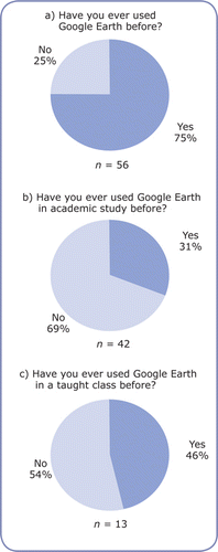
Fifty-six undergraduate students responded to the survey, comprising 33 first year (Group A) and 23 final year (Group B) students, and these data are presented in . Of the Group A students, 76% had used Google Earth before and, of those, 40% had used it in academic study, with only 50% of those having used it in a taught class before (). Of the Group B students, 74% had used Google Earth before, but only 18% had used it in academic study, and only 33% (1 student) of these had ever used it in a taught class before (). Within the totals for the combined group data, overall 75% of students had used Google Earth before, but of these, only 31% had used it for academic study, and only 46% of these (6 students) had used Google Earth in a taught class (). Therefore, only 11% of students surveyed had used Google Earth in a taught class before, and only 23% had used it in academic study of any kind. Some students who had used Google Earth before were informally asked about the context of the use, which included ‘A’ Level work at school and college, but also many said that they used it at home for recreation more than for study, with one student stating that they had added data (a photograph) to Google Earth as, what CitationGoodchild (2007) might call, ‘volunteered geography’. A few students also questioned whether “it was allowed” or appropriate to use web-based software, such as Google Earth, for academic study.
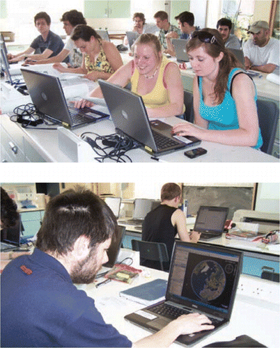
Figure 1 Students using Google Earth in a taught class, some for the first time.
Discussion
Although there are very similar percentages (c. 75%) of students from Group A (first year) and Group B (final year) who have used Google Earth before, there are considerably fewer final year students that have used it for academic study. One reason for this might be the relatively recent development of Google Earth and its public launch in June 2005. Most of the final year students surveyed in this study would have enrolled in the University in September 2005, whereas the first year students arrived in September 2007. Therefore, the only opportunities for prior use for these final year students would have been through their University studies, and it seems the opportunities were not presented to them and/or they were largely unaware of the academic applications Google Earth presents for geography undergraduate study. However, during the same time period, it appears that schools and colleges have used Google Earth slightly more and/ or students have been encouraged to use it, which is reflected in the higher number of first year students that have used it before in academic study.
Table 1 Results of 1st Year, 3rd (final) Year, and combined student respondents to the Google Earth prior use survey. Note that the percentages for questions b and c are based on the subtotals responding ‘yes’ to the previous question.
Surprisingly, 25% of students have not used Google Earth before, and less than a quarter of all students surveyed (23%) have used Google Earth in academic study, and only 11% have used it in class. This suggests that tutors, as well as students, are unaware of the potential Google Earth presents for blended learning, and that students are not being shown how to use it for academic study and/or not encouraged to use it. Although it is likely that this situation will change rapidly, especially given the rise in training in Google Earth offered by organisations such as the Royal Geographical Society (with IBG), this study suggests that some training is required to help tutors explore the potential of Google Earth for their teaching and their students learning. The low number of publications in the academic literature that cite the use of Google Earth (n = 123; ISI Web of Knowledge survey), suggests that this case study is not atypical.
Following this small survey, and the clear lack of experience in using Google Earth for academic study, students were given basic training in Google Earth functions to enable them to navigate around the digital globe, view landscapes from different perspectives, locate the field of view using latitude and longitude coordinates, download images of the field of view, and to establish altitude and compile topographic cross-sections. Tutors in the department were also encouraged to consider the use of Google Earth in their teaching.
Conclusions
This study surveyed 56 undergraduate geography students regarding their prior use of Google Earth. Although 75% had used Google Earth before, only 23% had previously used it for academic study, and only 11% had used it as part of a taught class. The main conclusions from this survey are that:
tutors can not assume that students will know how to use Google Earth and that training in its basic functions will be necessary, as 25% of those surveyed here have not previously used Google Earth at all, and only 23% have used it in academic study.;
schools and colleges may be ahead of universities in using Google Earth for study and/or encouraging its use by students in their private study, as the first years students had used Google Earth more in academic study than the final year students;
given the launch of Google Earth in 2005, newly recruited students are more likely to have more experience of using Google Earth in academic study than existing students;
both tutors and students should consider the potential applications of Google Earth for academic study, both as a teaching tool and a learning resource, particularly in blended learning contexts; and,
tutors might want to take advantage of training provided in Google Earth by organisations such as the Royal Geographical Society.
Figure 2 Results of 1st Year student respondents to the Google Earth prior use survey. Note that the percentages for questions b and c are based on the subtotals responding ‘yes’ to the previous question.
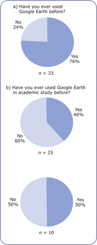
Figure 3 Results of 3rd (final) Year student respondents to the Google Earth prior use survey. Note that the percentages for questions b and c are based on the subtotals responding ‘yes’ to the previous question.
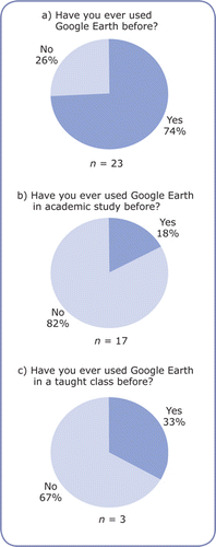
Figure 4 Results of combined student respondents to the Google Earth prior use survey. Note that the percentages for questions b and c are based on the subtotals responding ‘yes’ to the previous question.
Acknowledgements
This research is funded through a Small Project Grant from the Higher Education Academy Subject Centre for Geography, Earth and Environmental Sciences (HEAGEES). Undergraduate students at Bath Spa University are thanked for their participation in the survey.
References
- BallJ., CapanniN. and WattS., (2007) Virtual Reality for Mutual Understanding in Landscape Planning. International Journal of Social Sciences, 2, 78-88.
- BoulosM. N. K. (2005) Web GIS in practice III: creating a simple interactive map of England’s Strategic Health Authorities using Google Maps API, Google Earth KML, and MSN Virtual Earth Map Control. International Journal of Health Geographics, doi:10.1186/1476-072X-4-22.
- Buchanan-DunlopJ. (2008) Using Google Earth for fieldwork. Workshop run at the Geographical Association Conference, Guildford, Surrey.
- CaoY., KlammaR., SpaniolM., JarkeM., ToubekisG. and JansenM. (2006) Spatiotemporal Thematic Maps for Sustainable Development of Heritage Site Tourism. Proceedings, InterCarto — InterGIS 12, Berlin 2006, 1-12.
- DavisH. C. and FillK. (2007) Embedding blended learning in a university’s teaching culture: experiences and reflections. Journal of Educational Technology, 38, 817-828.
- ForesmanT. W. (2008) Evolution and implementation of the Digital Earth vision, technology and society. International Journal of Digital Earth, 1, 4-16.
- GoodchildM. F. (2007) Citizens as sensors: the world of volunteered geography. GeoJournal, 69, 211-221.
- ImbergerJ., WoodC. and MartiC. (2006) Centre for water research: leading edge technology wins international projects. Journal of the Australian Water Association, September, 73-76.
- KamadjeuR. (2009) Tracking the polio virus down the Congo River: a case study on the use of Google Earth™ in public health planning and mapping. International Journal of Health Geographics, 8, DOI: 10.1186/1476-072X-8-4.
- KatsarapongW., SrisangW., JaroensutasineeK. and JaroensutasineeM. (2007) Thailand National Biodiversity Database System with webMathematica and Google Earth. Proceedings of the World Academy of Science, Engineering and Technology, 21, 397-400.
- LeferT. B., AndersonM. R., FornariA., LambertA., FletcherJ. and BaqueroM. (2008) Using Google Earth as an innovative tool for community mapping. Public Health Reports, 123, 474-480.
- McCaffreyK. J. W., FeelyM., HennessyR. and ThompsonJ. (2008) Visualization of folding in marble outcrops, Conemara, western Ireland: an application of virtual outcrop technology. Geosphere, 4, 588-599.
- MonkkonenP. (2008) Using online satellite imagery as a research tool mapping changing patterns of urbanization in Mexico. Journal of Planning Education and Research, 28, 225-236.
- NourbakhshI., SargeantR., WrightA., CramerK., McLendonB. and JonesM. (2006) Mapping disaster zones. Nature, 439, 787-788.
- ParcakS. (2007) Google Earth and Egyptian archaeology: not just another pretty picture. Paper presented at the annual meeting of the The 58th Annual Meeting of the American Research Center in Egypt. From http://www.allacademic.com/meta/p187717_index.html
- PattersonT. C. (2007) Google Earth as a (not just) geography education tool. Journal of Geography, 106, 145-152.
- PugnaloniF., IssiniG., FangiG. and DangM. N. (2007) 3D digital reconstruction of Hue Complex of Monuments (Vietnam) and web application for a sustainable urban development. XXI International CIPA Symposium, 01-06 October 2007, Athens, Greece. From: http://cipa.icomos.org/fileadmin/papers/Athens2007/FP123.pdf
- SchultzR. B., KerskiJ. J. and PattersonT. C. (2008) The use of virtual globes as a spatial teaching tool with suggestions for metadata standards. Journal of Geography, 107, 27-34.
- SundvallE., NyströmM., ForssM., ChenR., PeterssonH. and ÅhlfeldtH. (2007) Graphical overview and navigation of electronic health records in a prototyping environment using Google Earth and openEHR archetypes. In: K.Kuhnet al, (eds) Medinfo 2007. IOS Press, 1043-1047.
- ThorndycraftV. and ThompsonD(2008) Google Earth, virtual fieldwork and quantitative methods in geomorphology. Geophysical Research Abstracts, 10, EGU2008-A-01510.
- WinlowH., SimmD. and HaslettS. (2007) Extended work-related placements in developing countries: supporting remote learning and assessment. Planet, 18, 28-32.