
Abstract
This paper presents preliminary results from an ethnoarchaeological study of animal husbandry in the modern village of Bestansur, situated in the lower Zagros Mountains of Iraqi Kurdistan. This research explores how modern families use and manage their livestock within the local landscape and identifies traces of this use. The aim is to provide the groundwork for future archaeological investigations focusing on the nearby Neolithic site of Bestansur. This is based on the premise that modern behaviours can suggest testable patterns for past practices within the same functional and ecological domains. Semi-structured interviews conducted with villagers from several households provided large amounts of information on modern behaviours that helped direct data collection, and which also illustrate notable shifts in practices and use of the local landscape over time. Strontium isotope analysis of modern plant material demonstrates that a measurable variation exists between the alluvial floodplain and the lower foothills, while analysis of modern dung samples shows clear variation between sheep/goat and cow dung, in terms of numbers of faecal spherulites. These results are specific to the local environment of Bestansur and can be used for evaluating and contextualising archaeological evidence as well as providing modern reference material for comparative purposes.
Introduction
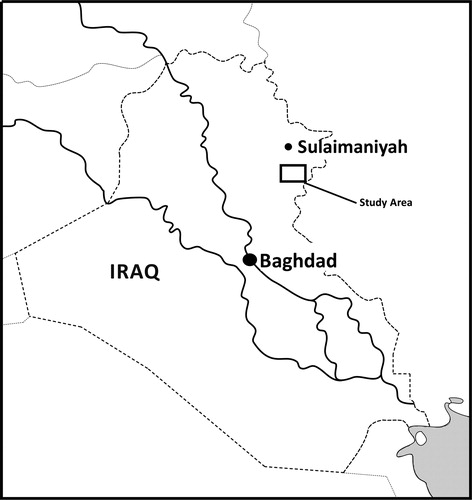
Ethnoarchaeological research has increasingly played an important role in the understanding and interpretation of archaeological deposits (see David and Kramer Citation2001: 1–32). This paper examines the modern rural village of Bestansur in the foothills of the Zagros Mountains, Iraqi Kurdistan (). This ethnographic research has been developed in the context of our excavations at the Early Neolithic site of Bestansur, located beside the modern village, and aims to contribute to archaeological analyses within the framework of the Central Zagros Archaeological Project (http://www.czap.org).
Figure 1. Location of the study area.
The purpose of this study is to elucidate aspects of the rural society and economy and how these function in the landscape and environment surrounding the village. Understanding the interplay of the varying environmental factors at a local and regional level, and their influences on animal husbandry (e.g. Bendrey Citation2011) and arable farming practices (e.g. Dreslerová et al. Citation2013) are essential for developing understanding of animal and plant use and economies at archaeological sites.
This programme of ethnoarchaeological research integrates closely with our ongoing research on mapping modern landscape isotopic and ecological variables (Bendrey et al. Citation2013). Modern behaviours can suggest testable patterns for past practices within the same topographical and ecological contexts (e.g. seasonal use of different altitudes for animal grazing), and if these areas are distinguishable by analyses of the modern biosphere, we may then be able to infer past use of these areas from isotopic analysis of archaeological finds (e.g. enamel in animal teeth formed at different seasons CitationBendrey et al. in press, Balasse et al. Citation2002b). It is essential to understand the full social and environmental context for integrated farming systems, to explore the drivers behind mobility, such as how mobile herding practices may be associated with differing local resource pressures.
This research aims to
| • | Understand how modern families use and manage their livestock within the local landscape (seasonally/geographically) and elucidate links between animal and plant resources that are an essential consideration for the elaboration of early Neolithic practices and the emergence of farming communities (e.g. Bogaard Citation2005; Henton Citation2012). | ||||
| • | Explore signatures left behind by the occupations and activities of this rural community (e.g. dung and local stable isotope ecology) that can potentially be identified as archaeological signatures on Neolithic sites such as Bestansur. | ||||
| • | Link the rural community to the physicality of the landscape, seasonality, climate and the overall context of the village, and evaluate constraints of the local environment on modern plant and animal husbandry. | ||||
In addition to addressing the need to explore signatures that may represent specific behaviours, which could be recognised archaeologically, our research strategy involves the creation of comparative datasets for which there is a requirement and demand (Lancelotti and Madella Citation2012). Creating our comparative datasets involves modern study of the use of plants and dung and to investigate spatial patterns of animal husbandry through isotopic analysis.
Study Area
Iraqi Kurdistan has a semi-arid climate with a strong continental component, characterised by cold and snowy winters and long, warm and dry summers () (Maran and Stevanovic Citation2009). Normally there is no rainfall between June and September. Variation in the topography of Iraqi Kurdistan significantly influences rainfall distribution, with precipitation rates decreasing from the mountains of the north-east to the desert-steppe of the south-west (Maran and Stevanovic Citation2009: 21–22). The significance of water availability on pastoral and arable farming is not just a question of the quantity of precipitation, but also evaporation rates, amongst other variables (Lioubimtseva and Henebry Citation2009; Bendrey Citation2011). presents average temperature, evaporation rate and rainfall for the region.
Table 1. Seasonal variation in the climate of Iraqi Kurdistan
The modern settlement of Bestansur is a rural farming village of approximately 50 households, located at c.550 m above sea level and c.700 m from the archaeological site (). The environment around the village of Bestansur can be split into different ecological and functional domains (Bendrey et al. Citation2012) ( to ). There are three distinct physical zones around Bestansur: the river catchment area, the farmed alluvial plains and the limestone foothills ( to 5, respectively). There is one main water source in the village, a large karst aquifer (Saed Ali Citation2008) located directly below the village (). Impermeable beds around Bestansur prevent groundwater from percolating deeper (Saed Ali Citation2008), resulting in a substantial water source for the people of Bestansur.
Figure 2. A simplified map of the local landscape around the modern village and archaeological mound of Bestansur, Iraqi Kurdistan. GPS Points: Plant, soil and water sample locations from the river catchment area, farmed alluvial plains and limestone foothills (referenced in text).
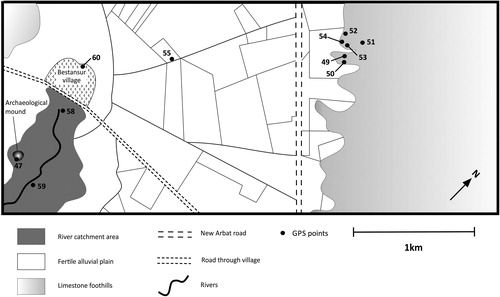
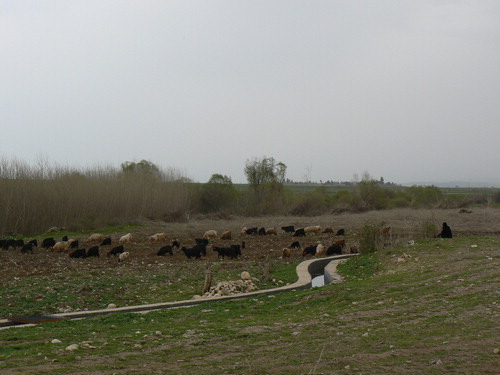
Figure 3. A goat herd daily grazing near to the archaeological mound in the river catchment area, Bestansur, Iraqi Kurdistan, spring 2012.
Archaeological excavations at Bestansur are investigating a Neolithic phase of activity at the site (http://www.czap.org). These deposits at Bestansur represent an Early Neolithic settlement, with rectilinear pise architecture, which is located within the river catchment area. The research presented in this paper is aimed at providing the groundwork for ongoing archaeological investigations at the site.
The geology of the area is characterised by Cretaceous bedrock overlain by Quaternary alluviation in the area, which supports modern arable farming (Saed Ali Citation2008). Beds of sandstone or siltstone are inter-bedded with shale, marl or marly limestone being characterised by Cretaceous age rocks such as pelagic limestone and clastic rocks (Saed Ali Citation2008). The land around Bestansur consists principally of a gently sloping agricultural plain which now makes up the main cultivation land in this area, with the surface of the landscape composed of slightly undulating thick alluvial sediments recharged mainly by the direct infiltration of rainfall (Saed Ali Citation2008). Saed Ali (Citation2008) identifies slight differences in age between the geology of the foothills and that of the alluvial Shaharizor Plain where Bestansur is located.
Research Context
Extensive ethnographic research has previously been carried out in the Zagros region of central western Iran during the 1970s and early 1980s. Studies focused on pastoral nomadism and transhumant stockbreeding groups (Hole Citation1978); economy, household size and village/domestic architecture (Kramer Citation1979, Citation1982); technology, the functions of artefacts and the nature of particular techniques (Watson Citation1979); and the correlation of the village with the land/environment, animals and plants (Kramer Citation1982). Limitations in extrapolating ethnographic observations to archaeological inference have been widely discussed (London Citation2000; David and Kramer Citation2001; Hamilakis and Anagnostoppoulos Citation2009). The ethnoarchaeological approach we follow is more archaeologically orientated, generating hypotheses from modern-day research that can be tested with archaeological datasets.
Linking Ethnography to Past Landscape and Resource Use
There is significant debate as to the expression of practices of mobility in the archaeological past. Research has been hampered by the fact that mobile groups often leave behind only ephemeral traces (Cribb Citation1991). Within the Near East, recent research by Porter argues for a re-positioning of our ideas on the degree of mobility of populations and that archaeological models be based more on the evidence than assumptions. We address this by considering the availability of geographically and seasonally discrete resources in the landscape around modern-day Bestansur, interviewing local families to understand current and recent patterns of land use (especially involving livestock movement), which will ultimately link in with knowledge on the full range of mobile subsistence practices in the region, from sedentary farming through to fully mobile pastoralism (e.g. Hole Citation1978; Gilbert Citation1983; Abdi Citation2003; Porter Citation2012).
In recent years, it has become possible to directly test assumed patterns of archaeological mobility for past populations, through analysis of the isotopic composition of preserved skeletal tissues that can be used as proxies for understanding geographical origins and movements of the individuals concerned (Balasse et al. Citation2002a; Mashkour et al. Citation2005; CitationBendrey et al. in press). A range of researchers have used studies of stable isotopes in archaeological specimens to explore questions of the ecology, management and dietary history of prehistoric animals, including analysis of oxygen isotope (δ18O) composition from sequential enamel samples to investigate birth seasonality in past animal populations (Balasse and Tresset Citation2007; Britton et al. Citation2009; Henton et al. Citation2010; Blaise and Balasse Citation2011; Henton Citation2012), which can be used to infer past herd management strategies and seasonal availability of food resources (e.g. Balasse et al. Citation2003). Linking data on strontium isotope ratios to the seasonal sequence identified from the δ18O values allows assessment of seasonal movement of the animal in relation to underlying geology (Balasse et al. Citation2002b; Evans et al. Citation2006; Britton et al. Citation2009). This has been undertaken to great effect in an ongoing project in the Altai Mountains, Mongolia, where local variation in geology and regional variation in oxygen isotope composition is providing detailed understanding of geographic origins and movements of animals, and the territories and migrations of the Iron Age pastoral nomads (CitationBendrey et al. in press).
Part of the study presented here involves isotopically mapping the local landscape to investigate potential variation in local biosphere values (Bendrey et al. Citation2012). It is envisaged this will form the basis for a control ‘map’ of the local region on which to test landscape-movement models generated by the ethnographic data. Ultimately, the aim is to analyse archaeological specimens from Bestansur and compare their isotopic compositions with these modern data, providing the framework to make inferences on past mobility and resource use in the local landscape.
Dung is a major signature of occupation and activity that is also explored in this study. To date ethnographic and experimental modern animal dung studies are limited, and where they exist these datasets are often small (). However, reference collections and comparative data from different types of animal dung are increasing. The small datasets which currently exist have provided important comparative information for archaeological studies (Lancelotti and Madella Citation2012; Portillo et al. Citation2012, Citation2014).
Table 2. Key ethnographic and experimental dung research by theme with references
Archaeological studies of animal dung are increasingly common although there is no standardised criteria for identification and analysis, numerous methods are currently employed (Shahack-Gross Citation2011: 206). Livestock dung at archaeological sites has been studied since the 1980s () and research concerning animal dung, its recognition, contents, use and survival are increasing. It is now widely recognised how useful the study of animal dung is as an archaeological resource ().
Table 3. Key archaeological dung research by theme with references
Phosphorus has long been regarded as a good indicator of human activity (Middleton and Price Citation1996), and elevated phosphorus is usually considered to be the principle indicator of the presence of dung in archaeological samples (Holliday and Gartner Citation2007; Lancelotti and Madella Citation2012). Phosphorus enters the soil through decomposition of organic materials and waste (Parnell et al. Citation2001; Holliday Citation2004; Roos and Nolan Citation2012). Organic matter deposited into sediments decomposes and organic phosphorus becomes ‘fixed’ relative to other ions and is absorbed onto surfaces of clay minerals or bound to iron, aluminium or calcium to form Fe-, Al or Ca-phosphate minerals (Holliday and Gartner Citation2007; Roos and Nolan Citation2012).
A recent study has shown that the application of portable X-ray fluorescence (pXRF) analysis in the field (rather than in laboratory conditions) is remarkably low at only 18% of 200 peer reviewed papers (Frahm and Doonan Citation2013). There is extensive ongoing debate about the accuracy and precision of handheld XRF devices and their successful application to archaeological contexts with significant results, and there is much scepticism over analytical performance (Frahm Citation2013; Frahm and Doonan Citation2013). Inter-instrument performance of pXRF equipment has proved that between different instruments statistically identical results are not produced (Goodale et al. Citation2012). Numerous highlighted limitations in the archaeological application of pXRF are recognised such as low precision, variable analytical accuracy, lack of instrument calibration and data correction, ignorance of surface morphology effects and difficulties with quantification due to a lack of appropriate standards (Goodale et al. Citation2012; Frahm Citation2013). While these limitations of pXRF are recognised, there are also advantages in using pXRF in archaeological applications such as rapid analysis, relatively good analytical precision for many elements, affordable portable technique and non-destructive analysis of samples (Goodale et al. Citation2012).
Portable XRF as a technique for elemental analysis may not be useful for in situ investigation of deposits in all environments and for all research goals (Frahm and Doonan Citation2013). However, the application within archaeological contexts to detect elevated levels of phosphorus, which are potentially indicative of animal dung, can be successful and therefore offers a useful technique that can be employed in this context. Furthermore, it can provide a basis for further in-field tests such as smear slide analysis which can confirm the presence of animal dung. Applying this methodology to our research with this specific objective provides a useful tool in the analysis of archaeological deposits, where the presence of elevated phosphorus within sediments is indicative of organic waste. Analysing modern dung samples by pXRF in comparison to a baseline dataset provided by modern natural soils provides comparative phosphorus values which can be applied to future archaeological investigations.
In addition to phosphorous values, phytoliths and spherulites may also be analysed in the study of animal dung. Phytoliths survive in dung and can provide a useful tool in archaeology for analysis of animal diet and inferring environment/ecology (Ghosh et al. Citation2008; Portillo et al. Citation2010; Shahack-Gross Citation2011). Calcareous spherulites are produced in the gut of animals during digestion and survive passage through the animal, they survive in dung deposits and are easily identified microscopically (Canti Citation1998). Numbers of faecal spherulites vary between species with sheep and goat being prolific producers of spherulites. Highest numbers of spherulites are produced by ruminant herbivores, numbers are low in omnivores and low-absent in carnivores (Canti Citation1999). Microscopic analysis of phytoliths and spherulites from modern dung samples provides a reference dataset that can be applied to archaeological investigations.
Methodology
Various complementary methods of investigation were undertaken in order to link the ethnographic observations and microscopic signatures of activity to scientific archaeological applications (Bendrey et al. Citation2013). These fall into three broad categories specifically designed to address our main research aims:
| • | Environmental characterisation: Was conducted to address the physicality of the landscape and provide a context in which to understand how the rural community's farming system is linked to this. The scientific analytical methodology applied for this modern characterisation also has potential archaeological applications. Specific methods employed were
| ||||
| • | Semi-structured interviews: This used a questionnaire, but allowed discussion to expand naturally where appropriate. The questionnaire was formatted to address modern use and management of livestock within the local landscape and elucidate links between animal and plant resources. This provided information on how the rural community is connected with the physical landscape (seasonality/geography) and directed sampling concerned with exploring signatures of occupation and activity. | ||||
| • | Dung sampling and analysis: Was carried out across the village and local landscape to explore signatures of occupation and use and create reference collections that permit ethnographic data to be robustly applied to archaeological situations. | ||||
Environmental Characterisation
A systematic study was undertaken, characterising the local landscape within the local environment following a ∼3 km transect across the three ecological and landscape domains identified around the village (). This involved the collection of samples for isotope analysis (water and plant material) and soil characterisation (soil samples for X-ray diffraction (XRD) and XRF).
Strontium Isotope Analysis
Twenty-five plant samples were collected from locations including the edges of cultivated fields and track ways, grazed fallow fields, margins of streams and the slopes of Bestansur mound. Multiple specimens were obtained for each collection with individuals selected that represented as many features of the complete plant as possible including flowers and/or fruits. Digital photographs and GPS readings were obtained for each collection (using a Panasonic DMC FZ100 camera and Garmin eTrex H, high sensitivity handheld GPS). Plants were pressed and dried before being exported to the UK and deposited at the University of Reading and Kew Herbaria for their curation and identification.
Leaf material was submitted for isotopic analysis from five plant samples representing the three ecological/functional domains identified along the transect (). These samples represent a preliminary dataset that will be expanded in the future. Specimens for isotopic analysis were collected from uncultivated areas to limit the potential effects of fertiliser on the resulting strontium isotope signatures (Vitòria et al. Citation2004).
Samples were weighed into pre-cleaned pressure vessels in a clean laboratory environment. After addition of 8M nitric acid, the samples were left overnight to pre-digest at room temperature. Further acid and hydrogen peroxide were next added before the samples were digested in a microwave oven, the program holding them at 175°C for 20 minutes. The final digestions were then allowed to dry down overnight on a hotplate.
The samples back into solution in nitric acid and hydrogen peroxide before allowing them to dry down once more. The final stage prior to strontium separation was to convert the in 6M HCl and evaporated to dryness.
The sample was taken up in 2·5 M HCl. Strontium was separated using conventional, Dowex® AG50 X8 resin ion exchange methods.
The Sr isotope compositions were determined by thermal ionisation mass spectroscopy using a Thermo Triton multi-collector mass spectrometer. Samples were loaded onto single re-filament following the method of Birck (Citation1986). The international standard NBS987 gave a 87Sr/86Sr ratio of 0·710254 ± 0·000006 (1SD, n = 10). All data are measured to better than ±0·000010 (2SE) internal precision. Strontium procedural blanks provided a negligible contribution.
Oxygen Isotope Analysis
Water samples were collected both from the Tanjero River, near its source (GPS 58), and from falling precipitation on days it rained (GPS 60). Ten water samples have been submitted for analysis of oxygen and hydrogen stable isotope composition at the University of Reading. We are currently awaiting these results for incorporation into this research; therefore, these results are not presented in this paper. Precipitation and river waters sampled in this project will act as comparative controls for likely input values to past animals, and so help interpret seasonal records, from sequential analysis of δ18O values in archaeological animal teeth.
Sampling/Analysis of Soils from the Alluvial Floodplains and Limestone Foothills
In order to assess the local sediments and geology five natural soil samples were collected from two of the three ecological/functional domains, the alluvial floodplains and the limestone foothills, surrounding the modern village of Bestansur (, GPS points 49, 51–53 and 59). Approximately 200 g of soil was placed in a sample bag and the GPS location recorded (GPS: 49, 51–53, 59). The samples were analysed using a Philips PW 1480 X-Ray fluorescence spectrometer with a dual anode Sc/Mo 100 kV 3 kW X-Ray tube and a Siemens D5000 X-Ray Diffraction Spectrometer. These samples were also analysed prior to sample preparation on a Niton XL3t GOLDD+ portable XRF analyser so that results could be directly comparable to modern and archaeological datasets analysed in situ during fieldwork.
Semi-structured Interviews
Interviews provided the opportunity to collect information on how plant and animal management are integrated and function sustainably at the level of individual households within the village's structure and economy. A questionnaire was designed with an animal-based component aimed at investigating modern husbandry practices within the local landscape and the environmental context. A supplementary plant-based component explored the role and function of informant's ‘kitchen gardens’. This term is used here to describe those gardens in which some, or all, of the plants being cultivated are for household consumption (also commonly referred to as ‘homegardens’ (Vogl et al. Citation2004) or the practice of ‘garden agriculture’ (Bogaard Citation2004)). For this, informants were asked about the purpose of their garden, what plants they grow and management strategies (e.g. seasonal planting, watering regimes) with a specific focus on links with animal management (e.g. manuring, foddering). The ethnographic data generated by these interviews helped direct modern data collection.
Dung Sampling and Analysis
A framework of strategic dung sampling was carried out with animal dung systematically sampled from animal pens in order to carry out analysis on known samples. We investigated the chemical signatures, specifically phosphorus values, and microscopic identification of dung deposits (through the presence of calcareous spherulites) and traces of animal diet, grazing/foddering patterns and how these are represented in the plant silica phytoliths extracted from the dung.
The ideal sample for XRF analysis has a flat and smooth surface, as surface irregularities introduce errors because x-rays are sensitive to topography (Frahm Citation2013). Within the wider Central Zagros Archaeological Project pXRF is being used to conduct minimally invasive in situ analyses of archaeological sediments to detect the presence of residual chemical signatures, specifically elevated phosphorus, as a potential indicator of the presence of animal dung. Therefore, unfortunately, in this context sample surfaces cannot be flat and smooth like the desired ideal sample; this represents one of the limitations of pXRF analysis of in situ archaeological sediments during fieldwork. For this reason, modern dung samples utilised within this research have not been prepared prior to analysis, as although it is recognised that the precision of measurements would increase with preparation through grinding, by grinding the dung samples the resulting readings would be ineffective for their intended purpose – which is to compare them to archaeological sediments that are also not prepared but analysed in situ. The analysis of dung samples by pXRF was therefore carried out directly in the field on raw, dried, non-prepared samples. In this study, the samples tested by pXRF are analysing total phosphorus in the samples, this approach has been applied in studies in the past for site prospection and spatial interpretations (Holliday and Gartner Citation2007; Roos and Nolan Citation2012; Hayes Citation2013).
Eleven modern dung samples from sheep/goats and cows were selected for preliminary analysis. Five of the six samples from sheep/goat dung were collected from mixed pens, the sixth originating from an individual young sheep. The samples were dried, then tested with the Niton XL3t GOLDD+ portable XRF analyser to characterise elements present (specifically phosphorus values). The modern dung samples were then burnt in an oven at 550°C for 4 hours to remove organic matter and c.100–200 mg was mounted onto a glass slide. The spherulites and phytoliths were then counted and quantified in 20 fields of view at a magnification of ×400 following a methodology similar to Katz et al. (Citation2010). The numbers and types of spherulites and phytoliths could then be related back to species and comparisons made between datasets.
Results and Interpretation
Strontium Isotope Analysis
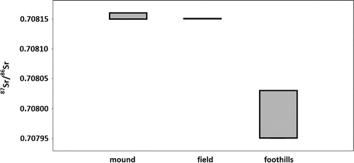
Our initial strontium isotope data indicate that the mound and fields have similar Sr values and that it may be possible to distinguish between the alluvial plain and the limestone foothills, which produced comparatively lower Sr values (; ). It is hoped continued sampling will generate further values for each area (and the wider landscape) to support these initial findings. This would form a foundation to explore possible Neolithic animal husbandry against the baseline of ethnographic data collected (i.e. time spent grazing in the different locations).
Table 4. Identification and location of collected plant samples with Citation87Sr/86Sr values
Soil Analysis: Samples Collected from the Alluvial Floodplains and Limestone Foothills
Utilising both the XRF () and XRD results from the natural soil samples, approximate semi-quantitative proportions of visible minerals in the natural sediments have been calculated (); this is carried out by using the approximate mass percentages.
Table 5. Results of x-ray fluorescence, results displayed as major elements in weight per cent and trace elements in parts per million (ppm)
Table 6. Semi-quantitative results of minerals present from x-ray diffraction*
Results from the XRF and XRD characterise the natural sediments around Bestansur as generally having a high clay content with the presence of quartz and iron-oxides. The clays that dominate these samples are predominantly montmorillonite or a similar smectite with a trace of kaolinite. The XRF results are consistent for these sediments being derived from limestone and marl bedrocks (containing calcium oxide and silicon dioxide). These results are similar to previously tested archaeological materials used to make pise walls at the Neolithic site of Bestansur (Matthews Citation2012), indicating that local sediments were an ideal natural resource for utilisation in the Neolithic village for construction purposes. Today, they are still utilising these in construction within the modern village, to build ovens/tanours, make mud bricks or to use as cement often in the construction of perimeter walls (specifically selecting the reddish rather than green clays). The results from the sediment analysis indicate that the natural material surrounding Bestansur is probably fairly sticky and cohesive, illustrating ideal properties for the use of this natural resource within the communities today.
presents the results for P2O5 values recorded by the lab-based XRF, the conversion into parts per million (ppm) phosphorus, and the results for phosphorus taken using the pXRF analyser (ppm). The phosphorus recorded as an oxide on the lab-based XRF (P2O5) has a slightly elevated value, between 349 and 1614 ppm (when converted from P2O5, see ). In comparison, the results from the pXRF analysis do not detect elevated phosphorus in any of the samples tested, the value is below the limit of detection (LOD) for phosphorus (<LOD). The LOD is the smallest concentration of an element that can be detected with reasonable certainty, generally regarded as indicating whether an element is present or not, but does not imply a value obtained is accurate (Niton Citation2014). This reinforces the reduced analytical precision of portable instruments but provides a comparable reading to the dung deposits (analysed by pXRF in situ) and for future comparison to archaeological deposits (also analysed in situ).
Table 7. Results for P2O5 values recorded by the lab-based XRF and the results for phosphorus taken using the pXRF analyser
Semi-structured Interviews
Four families from Bestansur village were interviewed to investigate human, plant and animal interactions; three families (Households 1, 2 and 4) provided information on present day activities ( and ), one (Household 4) on past and present activities (Tables 8–10) and the fourth (Household 3) gave information about activities c.70 years ago in the past (Tables and ).
Table 8. Households interviewed
Table 9. Questionnaires results from two families in relation to animal management in the past*
Table 10. Questionnaires results from three families in relation to present animal and plant management*
The results from informants discussing past and present practices provide information on the continuity of practices over time and demonstrate that there has been a relatively recent shift in grazing patterns (Tables –). In the past villagers grazed their animals on the limestone foothills for three months during the spring; a practice which is no longer in existence. The main catalyst for this change was described as the construction of the main road heading from Arbat travelling east over the border into Iran (). This effectively divides the landscape into two zones; the zone around the village containing the river catchment area () and the farmed alluvial floodplains () and the zone furthest from the village containing the limestone foothills ().
Table 11. Seasonal husbandry practices and land use
Figure 4. Sheep and goats daily grazing in fallow fields, on the alluvial flood plain Bestansur, Iraqi Kurdistan, summer 2012.
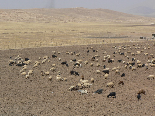
Figure 5. View towards the limestone Zagros foothills, looking northeast, from the village of Bestansur.
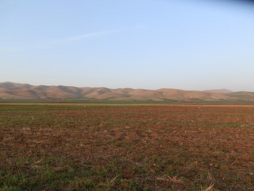
Figure 6. Strontium isotope ratios from plants growing on the foothills, fields and river catchment area (mound).
In addition to the changes which have occurred over time the informants also detailed the shifting patterns of land use and practice between seasons with the temporary penning of sheep/goat in the fallow fields during the summer months ( and ), which contrasts with cattle which are always kept in yards and enclosures within the village ( and ).
Figure 7. Sheep and goats being temporarily penned in fallow fields during the summer.
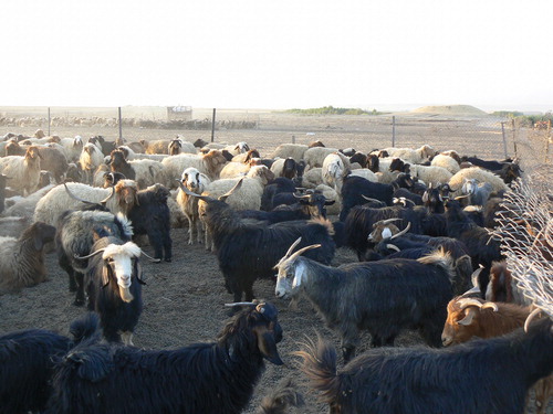
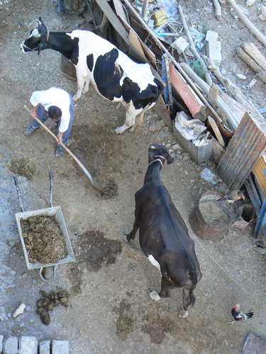
Figure 8. Cattle kept in yards/enclosures within the village.
Before the 1980s with the introduction of gas cooking and heating, dung was used as a fuel (). Today, dung is only used as a fertiliser, either directly deposited onto fallow fields during grazing or penning, collected into dung heads and added to ‘kitchen gardens’ ().
It is also evident that integration of plant and animal resources exists in the form of local consumption at a household and village level. Both today and in the past animals were raised for meat to be sold at market (Tables and ). To some degree this integration extends more externally in the form of regional consumption with related inputs and outputs cycled back into the local village economy ().
Figure 9. Animals, plants and the local economy. Simplified diagram of inputs/outputs and local/regional consumption.
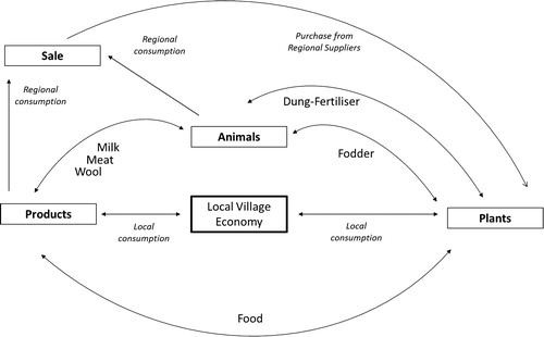
Today, household ‘kitchen gardens’ serve several purposes including provision of food, fodder and decoration see for the list of food plants cultivated. In contrast to animal resources these are solely consumed locally; however, food plants are also purchased from regional suppliers. Although small, our preliminary dataset clearly shows variations in garden size, household gender roles and plants grown (). Overall, the local village economy demonstrates a complex integration of people, plants and animals (using both primary and secondary products), that operates at both a local and regional level ().
Animal Dung Analysis
Eleven modern dung samples were collected and analysed for their phosphorus content, numbers of faecal spherulites and numbers/type of identifiable phytoliths ( and ).
Figure 10. Phytoliths and spherulites have been extracted and quantified from the dung collected from sheep/goat pens and cow sheds in Bestansur. 1: Dung samples being collected from sheep/goat pens. 2: Spherulites from sample ‘Household 2 #2’. 3: Spherulites from ‘Household 2 #3’. 4: Multicelled elongate dendritic husk phytoliths from Hordeum (barley) from ‘House hold 2 #4’. 5: Multicelled elongate smooth phytolith from grass stem/leaves from sample ‘House hold 2, cow far end’. 6: Stacked multicelled bulliform phytoliths from Phragmites (reed) from sample ‘Household 1 cow #1’. 7: Multicelled elongate dendritic husk phytoliths from Triticum (wheat) from sample ‘Household 1-Cow dung heap’.
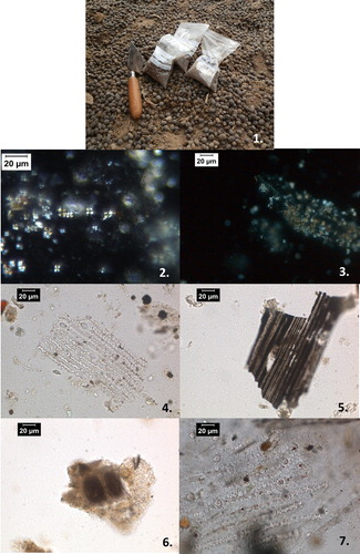
Table 12. Results of phosphorus values, spherulite and phytolith extraction from modern dung samples*
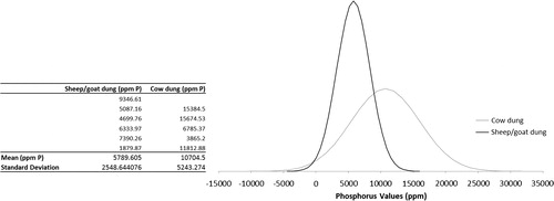
Comparing the averages, it initially appears that phosphorus values are higher in the cow dung comparatively to the sheep/goat dung (). However, when calculating the standard deviation and plotting the normal distribution of these results to determine whether the probability that this observation is correct it becomes apparent that there is in fact an overlap between the distribution curves for the sheep/goat and cow dung (). Therefore, the probability that these values exhibit a statistical difference is low. The peak represents the mean and the spread either side of the mean is determined by the standard deviation ().
Figure 11. Normal distribution for sheep/goat and cow dung showing the bell-shaped density curve described by its mean and standard deviation. The Peak represents the mean and the spread either side of the mean is determined by the standard deviation.
In order to place the phosphorus readings from dung samples taken with the pXRF in the field within the context of the surrounding natural sediments we can compare the phosphorus (ppm) and phosphorus oxide (P2O5) values. P2O5 values were obtained from the laboratory XRF for the five natural soil samples and have been converted to ppm to make comparable with the pXRF readings (). Values for phosphorus (converted from P2O5) are between 349 and 1614 ppm phosphorus and are generally lower that the phosphorus readings from the dried modern dung (with the exception of one value – ). However, within this study animal dung is being analysed by pXRF in the field to enable future comparison to archaeological materials. Portable XRF results are documented to have less precision and accuracy with a lower LOD for elements. However, as portable instrumentation is utilised in the field within this study and within the wider project, these phosphorus values obtained on the modern dung must be compared against values for the natural sediments by the same means of instrumentation. shows that the readings obtained with the pXRF (in order to be comparable) on the natural samples analysed exhibit a <LOD for phosphorus. Therefore, archaeologically when analysed by pXRF a deposit with elevated phosphorus could be indicative of animal dung, whereas a deposit with <LOD could be indicative of a natural soil.
There are clear differences between the faecal spherulite numbers, the average number counted over 20 fields of view, sheep/goat dung being 1230 spherulites in comparison to cow dung which is on average 0·6 spherulites. Distinction between sheep and goat dung has not been made in five of the six samples analysed because they originated from mixed penning ().
In general, there are very clear differences between the spherulite results between sheep/goat and cow dung. There is one clear outlier, Household 1 sheep, which produced minimal spherulites (), which can be explained by the age of the animal. The dung samples from household 2 sheep/goats derived from a sub-adult to adult herd, whereas Household 1 sheep was a young animal, c.6 months old. Previous analysis of animal dung from lambs and adult sheep has shown that spherulites are not produced by young animals and therefore the faeces of young lambs do not contain spherulites (Brochier et al. Citation1992). The presence of only 4 spherulites counted from Household 1 sheep dung supports this previous research, the fact that some are present could perhaps represent the beginning of faecal spherulite production.
The phytolith morphotypes identified were similar in both sheep/goat and cow dung. These findings are supported by the results from the semi-structured interviews, which suggested that there was little variation in the diet of sheep/goats and cows (Tables and ). However, there is a higher average percentage of dicotyledon phytoliths in the sheep/goat dung (8%) in comparison to the cow dung (1%). This suggests that sheep and goats are more prone to browsing on the leaves of shrubs and trees than cows. This small 7% difference is significant due to the limited production of phytoliths within dicotyledonous plants in comparison to prolific phytolith production in monocotyledonous plants (Shillito Citation2013). Dicots produce very low numbers of phytoliths up to twenty times less than monocots (Albert et al. Citation2003; Jenkins and Rosen Citation2007). The diet of Household 1 sheep was known to include tree leaves and bark, but conversely no dicot phytoliths were recovered from the dung sample. This sample was collected from an animal kept within the property enclosure of the household and not grazed daily and whose diet was observed to be relatively variable and inconsistent. Therefore, the dung sample could have been collected from a sample that represented a period of time when only monocots had been consumed. In comparison, the animals from Household 2 were taken out to graze along the same daily route. Therefore, the phytolith assemblage observed in the dung samples obtained from these animals represents a consistent and repetitive diet.
These results give an indication of the variation between species and the specific composition of the different animal dungs; this information can then be used in the analysis of archaeological dung deposits. The distinction between types of animal dung identified in micromorphological thin section can be inferred by the numbers of faecal spherulites and the phytolith assemblage present. However, the analyst must always take into consideration taphonomic processes that affect the deposition and burial of animal dung, as well as the context that the deposits are recovered in. These samples analysed in this small dataset are unburnt animal dung samples collected from the surface (meaning they have not been subject to sub-surface taphonomic processes). The recovery of dung in various archaeological deposits will result in differential preservation of the dung, these deposits include middens, ash, compacted pen deposits, building materials. Faecal spherulites dissolve/degrade in a pH of above 7 (Canti Citation1999) and above temperatures of approximately 650–900°C (Matthews Citation2010). Phytoliths do not survive in a pH above 8·5 and silica phytoliths melt at temperatures of above approximately 850°C (Canti Citation2003).
Discussion, Conclusion and Future Direction
The preliminary results presented here come from a small dataset, but indicate that a huge wealth of information is embedded in local rural communities which can be readily accessed and utilised to aid archaeological interpretation. Such information risks being lost as these practices and traditions are being abandoned and younger generations lack the first-hand experience and knowledge of their forbearers. However, by recording oral histories of the rural life of this area we are learning about changing practices and relationships within the surrounding countryside. The marked differences between the practices of families with large and small herds as well as the contrast to just c.70 years ago highlights the need for extensive investigation into local knowledge, the continuity of these practices over time and how they are constrained within the local landscape.
Analysis of species-specific dung samples has enabled the assessment of variation in spherulite production, phytolith concentration and phosphorus values across different species. While the phosphorus values generally appear higher in cow dung, the overlap of the normal distribution curves shows that this difference is not statistically significant within the small dataset analysed. The dung samples analysed exhibit a clear variation in faecal spherulites between samples from different species. Adult sheep/goats produce more spherulites in comparison to cows; however, clear outliers have been recognised in the form of low faecal spherulite production in immature sheep. The archaeological interpretation of animal dung to species should therefore be cautiously used without further clarifying evidence, for example species specific GC MS (see Bull et al. Citation1999; Shillito et al. Citation2011a). This variation between species observed in this preliminary dataset reinforces existing work on spherulite production (Canti Citation1999) but also provides a region-specific dataset comparable within the environment of our archaeological study area ( and ). The average percentage difference in dicot phytoliths suggests that sheep and goats generally are more prone to browsing on the leaves of shrubs and trees than cows. The absence of dicot phytoliths from Household 1 sheep dung can be attributed to specific grazing patterns and inconsistency in feeding regimes. These results have potentially significant implications for the interpretation of variations in archaeological dung signatures found across Early Neolithic sites. To date, only herbivore dung has been analysed within this study and as an expansion of this reference collection we will collect and analyse dung from a wider range of animals within the vicinity of Bestansur including separate sheep and goat samples and omnivores.
Results from preliminary isotope analysis demonstrate measurable variation exists in the physical environment. This is based on a number of small datasets, which will be expanded in the future, to test whether the differences in the values present here are significant and meaningful for archaeological applications. Areas around the archaeological mound at Bestansur and the farmed fields of the alluvial floodplain have different strontium isotope values compared to those in the limestone foothills. These control data can be used as a framework to infer seasonal landscape movements, or not, of analysed Neolithic animal remains in relation to the underlying geology. Isotopic analyses of local river and precipitation samples taken at different times of the year will also act as proxy control data for input values to the archaeological livestock in the final analysis. Further collection and analysis of samples is planned to substantiate the pattern identified here. Plant and water samples collected during the spring 2013 field season are currently being considered for strontium and oxygen isotope analysis.
This first phase of ethnoarchaeological research at Bestansur has mainly been exploratory with subsequent phases designed to more rigorously test our preliminary findings. Future expansion of this dataset is also required, with additional families (locally and regionally) being interviewed, and further laboratory analysis on existing samples collected during this first phase of ethnographic study at Bestansur. Additional work currently being carried out includes assessing the changes which occur in dung signatures as a result of exposure to fire (Elliott et al. Citation2013). The recovery and identification of charred macrobotanical assemblages originating from animal dung in archaeological deposits at Neolithic sites in Southwest Asia has been frequently discussed (Miller and Smart Citation1984; Miller Citation1996; Charles Citation1998; Wallace and Charles Citation2013). Carrying out experimental dung burning would therefore enable an expansion of the reference collection, which can be linked back to the archaeological data, for both macrobotanical and phytolith assemblages. It will enable us to observe taphonomic changes and preservation of the components in different types of dung resulting from exposure to fire. We are also currently undertaking a review of grazing patterns based on discussion with informants and direct observation of both sheep/goat and cattle herds (involving an integrated programme of GPS mapping of mobility). By directly observing animal herds and their grazing patterns, information that may have been ‘lost in translation’ or unintentionally omitted is gained. For example, the duration and pattern of grazing enables observations between preferential grazing and ‘accidental grazing’ of animals in transit.
This ongoing research is generating a more meaningful and accurate dataset to inform on, and link back to, our archaeological material.
Acknowledgements
This research was carried out within the framework of the Central Zagros Archaeological Project (CZAP). We would like to thank the co-directors Professor Roger Matthews and Dr Wendy Matthews for their support and guidance with this research. And we would like to thank the Arts and Humanities Research Council (AHRC) who funded this research as part of a four year CZAP research framework. We would like to thank Franz Street and Mike Andrews with their assistance with the XRF and XRD processing and interpretation and also the Reading and Kew Herbariums for their identifications of the modern plant material, in particular Sue Mott (Reading) and Mark Nesbitt (Kew) for their advice and assistance. We would like to especially thank the families of Bestansur, without which this research would not have been possible.
References
- Abdi, K. 2003. The early development of pastoralism in the Central Zagros mountains. Journal of World Prehistory 17, 395–448.
- Albert, R. M., Bar-Yosef, O., Meignen, L. and Weiner, S. 2003. Quantitative phytolith study of hearths from the Natufian and Middle Palaeolithic levels of Hayonim Cave (Galilee, Israel). Journal of Archaeological Science 30, 461–80.
- Albert, R. M., Shahack-Gross, R., Cabanes, D., Gilboa, A., Lev-Yandun, S., Portillo, M., Sharon, I., Boaretto, E. and Weiner, S. 2008. Phytolith rich layers from the Late Bronze Age and Iron Ages at Tell Dor (Israel): mode of formation and archaeological significance. Journal of Archaeological Science 35, 57–75.
- Anderson, S. and Ertug-Yaras, F. 1998. Fuel fodder and faeces: an ethnographic and botanical study of dung fuel use in central Anatolia. Environmental Archaeology 1, 99–110.
- Balasse, M. and Tresset, T. 2007. Environmental constraints on the reproductive activity of domestic sheep and cattle: what latitude for the herder? Anthropozoologica 42, 71–88.
- Balasse, M., Ambrose, S., Smith, A. and Price, D. 2002a. The seasonal mobility model for prehistoric herders in the south-west Cape of South Africa assessed by isotopic analysis of sheep tooth enamel. Journal of Archaeological Science 29, 917–32.
- Balasse, M., Stanley, A. H., Smith, A. B. and T. D., P. 2002b. The seasonal mobility model for prehistoric herders in the south-western cape of South Africa assessed by isotopic analysis of sheep tooth enamel. Journal of Archaeological Science 29, 917–32.
- Balasse, M., Smith, A., Ambrose, S. and Leigh, S. 2003. Determining sheep birth seasonality by analysis of tooth enamel oxygen isotope ratios: the Late Stone Age site of Kasteelberg (South Africa). Journal of Archaeological Science 30, 205–15.
- Bendrey, R. 2011. Some like it hot: environmental determinism and the pastoral economies of the later prehistoric Eurasian steppe. Pastoralism: Research, Policy and Practice, 1, 1–16.
- Bendrey, R., Whitlam, J., Elliott, S. and Martin, G. 2012. Chapter Eight: Modern Landscape Transect Sampling Programme in Matthews, R. and Matthews, W. (eds.), Excavations at Bestansur, Sulaimaniyah Province, Kurdistan Regional Government, Republic of Iraq 17th March–24th April 2012. Unpublished Central Zagros Archaeological Project Archive Report: 101–105.
- Bendrey, R., Whitlam, J. and Elliott, S. 2013. Ethnoarchaeological research in Iraqi Kurdistan. Association for Environmental Archaeology Newsletter 122, 3–4.
- Bendrey, R., Lepetz, S., Zazzo, A., Balasse, M., Turbat, T., Giscard, P.-H., Vella, D., Zaitseva, G. I., Chugunov, K. V., Ughetto, J., Debue, K. and Vigne, J.-D. in press. Nomads, horses and mobility: an assessment of geographic origins of Iron Age horses found at Tsengel Khairkhan and Baga Turgen Gol (Mongolian Altai) based on oxygen isotope compositions of tooth enamel in Mashkour, M. and Beech, M. (eds.), Proceedings of the 9th ASWA Conference, Al Ain. Oxford: Oxbow.
- Birck, J. L. 1986. Precision K–Rb–Sr isotopic analysis – application to Rb–Sr chronology. Chemical Geology 56, 73–83.
- Blaise, E. and Balasse, M. 2011. Seasonality and season of birth in modern and late Neolithic sheep from south-eastern France using tooth enamel δ18O analysis. Journal of Archaeological Science 38, 3085–93.
- Bogaard, A. 2004. Neolithic Farming in Central Europe: An Archaeobotanical Study of Crop Husbandry Practices. London: Routledge.
- Bogaard, A. 2005. ‘Garden agriculture’ and the nature of early farming in Europe and the Near East. World Archaeology 37, 177–96.
- Britton, K., Grimes, V., Dau, J. and Richards, M. P. 2009. Reconstructing faunal migrations using intra-tooth sampling and strontium and oxygen isotope analyses: a case study of modern caribou (Rangifer tarandus granti). Journal of Archaeological Science 36, 1163–72.
- Brochier, J. E., Villa, P., Giacomarra, M. and Tagliacozzo, A. 1992. Shepherds and sediments: Geo-ethnoarchaeology of pastoral sites. Journal of Anthropological Archaeology 11, 47–102.
- Bull, I. D. and Evershed, R. P. 2012. Organic geochemical signatures of ancient manure use, pp. 31–77 in Jones, R. (ed.), Manure Matters. Historical, Archaeological and Ethnographic Perspectives. Farnham: Ashgate Publishing Limited.
- Bull, I. D., Simpson, I. A., Van Bergen, P. F. and Evershed, R. P. 1999. Muck‘n'molecules: organic geochemical methods for detecting ancient manuring. ANTIQUITY-OXFORD- 73, 86–96.
- Bull, I. D., Lockheart, M. J., Elhmmali, M. M., Roberts, D. J. and Evershed, R. P. 2002. The origin of faeces by means of Biomarker Detection. Environment International 27, 647–54.
- Canti, M. 1998. The Micromorphological Identification of Faecal Spherulites from Archaeological and Modern Materials. Journal of Archaeological Science 25, 435–44.
- Canti, M. G. 1999. The production and preservation of faecal spherulites: animals, environment and taphonomy. Journal of Archaeological Science 26, 251–8.
- Canti, M. G. 2003. Aspects of the chemical and microscopic characteristics of plant ashes found in archaeological soils. Catena 54, 339–61.
- Charles, M. 1998. Fodder from dung: the recognition and interpretation of dung-derived plant material from archaeological sites. Environmental Archaeology: The Journal of Human Palaeoecology 1, 111–22.
- Charles, M., Halstead, P. and Jones, G. 1998. The archaeology of fodder: introduction. Environmental Archaeology: The Journal of Human Palaeoecology, 1, i–ii.
- Cribb, R. 1991. Nomads in Archaeology. Cambridge: Cambridge University Press.
- David, N. and Kramer, C. 2001. Ethnoarchaeology in Action. Cambridge: Cambridge University Press.
- Dreslerová, D., Kočár, P., Chuman, T., Šefrna, L. and Poništiak, Š. 2013. Variety in cereal cultivation in the Late Bronze and Early Iron Ages in relation to environmental conditions. Journal of Archaeological Science 40, 1988–2000.
- Elliott, S., Bendrey, R. and Rouf, K. 2013. Chapter eleven: ethnography of animal Husbandry, Bestansur, in Matthews, R. and Matthews, W. (eds.), Excavations at Bestansur, Sulaimaniyah Province, Kurdistan Regional Government, Republic of Iraq 21st March–24th April 2013. Unpublished Central Zagros Archaeological Project Archive Report: 85–92.
- Evans, J. A., Chenery, C. A. and Fitzpatrick, A. P. 2006. Bronze Age childhood migration of individuals near Stonehenge, revealed by strontium and oxygen isotope tooth enamel analysis. Archaeometry 48, 309–21.
- Forbes, H. 1998. European agriculture viewed bottom-side upwards: fodder: and forage-provision in a traditional Greek community. Environmental Archaeology 1, 19–34.
- Forbes, H. 2012. Lost souls: ethnographic observations on manuring practices in a Mediterranian community, pp. 159–72 in Jones, R. (ed.), Manure Matters: Historical, Archaeological and Ethnographic Perspectives. Aldershot: Ashgate.
- Frahm, E. 2013. Validity of ‘off-the-shelf’ handheld portable XRF for sourcing Near Eastern obsidian chip debris. Journal of Archaeological Science 40, 1080–92.
- Frahm, E. and Doonan, R. C. 2013. The technological versus methodological revolution of portable XRF in archaeology. Journal of Archaeological Science 40, 1425–34.
- Ghosh, R., Gupta, S., Bera, S., Jiang, H., Li, X. and Li, C. 2008. Ovi-caprid dung as an indicator of paleovegetation and paleoclimate in northwest China. Quaternary Research 70, 149–57.
- Gilbert, A. S. 1983. On the origins of specialized nomadic pastoralism in western Iran. World Archaeology 15, 105–19.
- Goodale, N., Bailey, D. G., Jones, G. T., Prescott, C., Scholz, E., Stagliano, N. and Lewis, C. 2012. pXRF: a study of inter-instrument performance. Journal of Archaeological Science 39, 875–83.
- Haddad, R. H., Smoor, P. B., Basho, D. Y., Sarbaro, S. K., Al-Azzawi, A. L. and Damarchi, M. S. 1975. Ground Water Resources of Erbil Area. IARNR Technical Bulletin, 70, Baghdad, Iraq; Institute for Applied Research on Natural Resources.
- Hall, A. and Kenward, H. 1998. Disentangling dung: pathways to stable manure. Environmental Archaeology 1, 123–6.
- Halstead, P. and Tierney, J. 1998. Leafy hay: an ethnoarchaeological study in NW Greece. Environmental archaeology 1, 71–80.
- Hamilakis, Y. and Anagnostoppoulos, A. 2009. What is Archaeological Ethnography? Public Archaeolaeology 8, 65–87.
- Hayes, K. 2013. Parameters in the use of pXRF for archaeological site prospection: a case study at the Reaume Fort Site, Central Minnesota. Journal of Archaeological Science 40, 3193–211.
- Henton, E. 2012. The combined use of oxygen isotopes and microwear in sheep teeth to elucidate seasonal management of domestic herds: the case study of Çatalhöyük, central Anatolia. Journal of Archaeological Science 39, 3264–76.
- Henton, E., Meier-Augenstein, W. and Kemp, H. F. 2010. The use of oxygen isotopes in sheep molars to investigate past herding practices at the Neolithic settlement of Çatalhöyük, Central Anatolia. Archaeometry 52, 429–49.
- Hole, F. 1978. Pastoral Nomadism in Western Iran, pp. 127–67 in Gould, R. A. (ed.), Explorations in Ethnoarchaeology. Albuquerque: University of New Mexico Press.
- Holliday, V. T. 2004. Soils in Archaeological Research. Oxford: Oxford University Press.
- Holliday, V. T. and Gartner, W. G. 2007. Methods of soil P analysis in archaeology. Journal of Archaeological Science 34, 301–33.
- Jenkins, E. L. and Rosen, A. 2007. The phytoliths, pp. 429–36 in Finlayson, B. and Mithen, S. (eds.), The Early Prehistory of Wadi Faynan, Southern Jordan: Archaeological Survey of Wadis Faynan, Ghuwayr and Al-Bustan and Evaluation of the Pre-pottery Neolithic A Site of WF16. Oxford: Oxbow Books.
- Jones, G. 1998. Distinguishing food from fodder in the archaeobotanical record. Environmental Archaeology 1, 95–8.
- Jones, R. 2012a. Understanding Medieval Manure, pp. 145–58 in Jones, R. (ed.), Manure Matters. Historical, Archaeological and Ethnographic Perspectives. Farnham: Ashgate Publishing Limited.
- Jones, R. 2012b. Why Manure Matters, pp. 1–11 in: Jones, R. (ed.), Manure Matters. Historical, Archaeological and Ethnographic Perspectives. Farnham: Ashgate Publishing Limited.
- Katz, O., Cabanes, D., Weiner, S., Maeir, A. M., Boaretto, E. and Shahack-Gross, R. 2010. Rapid phytolith extraction for analysis of phytolith concentrations and assemblages during an excavation: an application at Tell es-Safi/Gath, Israel. Journal of Archaeological Science 37, 1557–63.
- Kenward, H. and Hall, A. 1997. Enhancing Bioarchaeological Interpretation using indicator groups: Stable manure as a Paradigm. Journal of Archaeological Science 24, 663–73.
- Kramer, C. 1979. An archaeological view of a contemporary Kurdish village: domestic architecture, household size, and wealth, pp. 139–63 in Kramer, C. (ed.), Ethnoarchaeology: implications of Ethnography for Archaeology. New York: Columbia University Press.
- Kramer, C. 1982. Village Ethnoarchaeology: Rural Iran in Archaeological Perspective. New York: Academic Press.
- Lancelotti, C. and Madella, M. 2012. The ‘invisible’ product: developing markers for identifying dung in archaeological contexts. Journal of Archaeological Science 38, 953–63.
- Lioubimtseva, E. and Henebry, G. M. 2009. Climate and environmental change in arid Central Asia: Impacts, vulnerability, and adaptations. Journal of Arid Environments 73, 963–77.
- London, G. 2000. Ethnoarchaeology and Interpretations of the Past. East Archaeology 63, 2.
- Macphail, R. I. and Goldberg, P. 1985. Recent advances in micromorphological interpretations of soils and sediments from archaeological sites, pp. 1–24e in Barham, A. J. and Macphail, R. I. (eds.), Archaeological Sediments and Soils: Analysis, Interpretation and Management. London: Institute of Archaeology, University College London.
- Macphail, R. I., Courty, M. A., Hather, J. and Wattez, J. 1997. The soil micromorphological evidence of domestic occupation and stabling activities, pp. 53–88 in Maggi, R. (ed.), Arene Candide: A Functional and Environmental Assessment of the Holocene sequences excavated by Bernado Brea (1940–1950). Umana: Meomorie dell Instituto di Paleontologia.
- Macphail, R. I., Cruise, G. M., Allen, M. J., Linderholm, J. and Reynolds, P. 2004. Archaeological soil and pollen analysis of experimental floor deposits; with special reference to Butzer Ancient Farm, Hampshire, UK. Journal of Archaeological Science 31, 175–91.
- Maran, A. and Stevanovic, Z. 2009. The Iraqi Kurdistan Environment: An Invitation to Discover, Belgrade, IK: Consulting Engineers, Ltd.
- Mashkour, M., Bocherens, H. and Moussa, I. 2005. Long distance movement of sheep and goats of Bakhtiari nomads tracked with intra-tooth variations of stable isotopes (13C and 18O), pp. 113–124 in Davies, J., Fabiš, M., Mainland, I., Richards, M. and Thomas, R. (eds.), Diet and Health in Past Animal Populations: Current Research and Future Directions. Oxford: Oxbow books.
- Matthews, W. 2005. Micromorphological and microstratigraphic traces of uses and concepts of space, pp. 355–98 in Hodder, I. (ed.), Inhabiting Çatalhöyük, Reports from the 1995–99 Seasons. Ankara: British Institute of Archaeology.
- Matthews, W. 2008. Micro-contextual analysis of plant remains: study of human-environment inter-relationships in early agricultural and urban settlements in the Ancient Near East, pp. 143–55 in Kühne, H., Czichon, R. M. and Kreppner, F. J. (eds.), Volume 1: The Reconstruction of the Environment: Natural Resources and Human Interrelationships through Time. Art History: Visual Communication. Wiesbaden: Harrassowitz Verlag.
- Matthews, W. 2010. Geoarchaeology and taphonomy of plant remains and microarchaeological residues in early urban environments in the Ancient Near East. Quaternary International 214, 98–113.
- Matthews, W. 2012. Chapter Four: Architecture, traces of activities and site formation processes, in Matthews, R. and Matthews, W. (eds.), Excavations at Bestansur and Shimshara, Sulaimaniyah Province, Kurdistan Regional Government, Republic of Iraq 18th August – 27th September 2012. Central Zagros Archaeological Project Archive Report: 19–28.
- Matthews, W., French, C. A. I., Lawrence, T., Cutler, D. F. and Jones, M. K. 1997. Microstratigraphic traces of site formation processes and human activities. World Archaeology 29, 281–308.
- Middleton, W. D. and Price, D. T. 1996. Identification of activity areas by multi-element characterization of sediments from modern and archaeological house floors using inductively coupled plasma-atomic emission spectroscopy. Journal of Archaeological Science 23(5): 673–687.
- Miller, N. and Smart, T. L. 1984. Intentional Burning of Dung as a fuel: a mechanism for the incorporation of charred seeds into the archaeological record. Journal of Ethnobiology 4, 15–28.
- Miller, N. F. 1996. Seed eaters of the ancient Near East: human or herbivore? Current Anthropology 37, 521–8.
- Niton, T. S. 2014. General XRF Glossary. http://www.niton.com/en/portable-xrf-technology/xrf-glossary/general-xrf-glossary#16d368f8-37c4-4d21-a9c8-d34218f0361e [Online].
- Parnell, J. J., Terry, R. E. and Golden, C. 2001. Using in – field phosphate testing to rapidly identify middens at Piedras Negras, Guatemala. Geoarchaeology 16, 855–73.
- Porter, A. 2012. Mobile Pastoralism and the Formation of Near Eastern Civilizations: Weaving Together Society. Cambridge: Cambridge University Press.
- Portillo, M., Albert, R. and Henry, D. 2009. Domestic activities and spatial distribution in Ain Ab Nukhayla (Wadi Rum, Southern Jordan): The use of phytoliths and spherulites studies. Quaternary International 193, 174–83.
- Portillo, M., Albert, R. M., Kadowak, S. and Nishiak, Y. 2010. Domestic activities at Early Neolithic Tell Seker al-Aheimar (Upper Khabur, Northeastern Syria) through phytoliths and spherulites studies, pp. 19–30 in Delhon, C., Théry-Parisot, I. and Thiébault, S. (eds.), Des hommes et des plantes: exploitation du milieu et gestion des ressources végétales de la Préhistoire à nos jours. Antibes: ADPCA.
- Portillo, M., Valenzuela, S. and Albert, R. 2012. Domestic patterns in the Numidian site of Althiburos (northern Tunisia): The results from a combined study of animal bones, dung and plant remains. Quaternary International 275, 84–96.
- Portillo, M., Kadowaki, S., Nishiaki, Y. and Albert, R. M. 2014. Early Neolithic household behavior at Tell Seker al-Aheimar (Upper Khabur, Syria): a comparison to ethnoarchaeological study of phytoliths and dung spherulites. Journal of Archaeological Science 42, 107–18.
- Powers, A. H., Padmore, J. and Gilbertson, D. D. 1989. Studies of late prehistoric and modern opal phytoliths from coastal sand dunes and machair in Northwest Britain. Journal of Archaeological Science 16, 27–45.
- Reddy, S. N. 1999. Fuelling the hearths in India: the role of dung in paleoethnobotanical interpretation. Paleorient 24, 61–70.
- Roos, C. I. and Nolan, K. C. 2012. Phosphates, plowzones, and plazas: a minimally invasive approach to settlement structure of plowed village sites. Journal of Archaeological Science 39, 23–32.
- Rosen, A. M., Savinetsky, A. B., Plakht, Y., Kisseleva, N. K., Khassanov, B. F., Pereladov, A. M. and Haiman, M. 2005. Dung in the desert: preliminary results of the Negev Holocene Ecology Project. Current Anthropology 46, 317–27.
- Saed Ali, S. 2008. Geologija i hidrogeologija arazurpiramagrun basena u oblasti sulejmanije, severoistoèni irak. univerzitet u beogradu rudarsko-geoloki fakultet. Beograd. Available on-line: http://www.kurdistan-geology.com/PDF/Thesis/PhD%20thesis%20of%20Dr%20Salahaddin%20Saed%20Ali,%20hydrogeology%20of%20Sharazoor%20basin,%202008.pdf.
- Shahack-Gross, R. 2011. Herbivorous livestock dung: formation, taphonomy, methods for identification, and archaeological significance. Journal of Archaeological Science 38, 205–18.
- Shahack-Gross, R. and Finkelstein, I. 2008. Subsistence practices in an arid environment: a geoarchaeological investigation in an Iron Age site, the Negev Highlands, Israel. Journal of Archaeological Science 35, 965–82.
- Shahack-Gross, R., Marshall, F. and Weiner, S. 2003. Geo-Ethnoarchaeology of Pastoral sites: the identification of livestock enclosures in Abandonned Maasai Settlements. Journal of Archaeological Science 30, 439–59.
- Shahack-Gross, R., Marshall, F., Ryan, K. and Weiner, S. 2004. Reconstruction of spatial organization in abandoned Maasai settlements: implications for site structure in the Pastoral Neolithic of East Africa. Journal of Archaeological Science 31, 1395–411.
- Shahack-Gross, R., Albert, R., Gilboa, A., Nagar-Hilman, O., Sharon, I. and Weiner, S. 2005. Geoarchaeologi in an urban context: the uses of space in a Phoenician monumental building at Tell Dor (Israel). Journal of Archaeological Science 32, 1417–31.
- Shillito, L.-M. 2013. Grains of Truth or transparent blindfolds? A review of current debates in archaeological phytolith analysis. Vegetation History and Archaeobotany 22, 71–82.
- Shillito, L.-M., Bull, I. D., Matthews, W., Almond, M. J., Williams, J. M. and Evershed, R. P. 2011a. Biomolecular and micromorphological analysis of suspected faecal deposits at Neolithic Çatalhöyük, Turkey. Journal of Archaeological Science 38, 1869–77.
- Shillito, L.-M., Bull, I. D., Matthews, W., Almond, M. J., Williams, J. M. and Evershed, R. P. 2011b. Biomolecular and micromorphological analysis of suspected faecal deposits at Neolithic Çatalhöyük, Turkey. Journal of Archaeological Science 38, 1869–977.
- Sillar, B. 1999. Dung by preference: the choice of fuel as an example of how Andean pottery production is embedded within wider technical, social and economic practices. Archaeometry, 42, 43–60.
- Valamoti, S. M. 2013. Towards a distinction between digested and undigested glume bases in the archaeobotanical record from Neolithic northern Greece: a prelimimary experimental investigation. Environmental Archaeology 18, 31–42.
- Varisco, D. 2012. Zibl and Zirā’a: Cominf to terms with manure in Arab Agriculture, pp. 129–43 in Jones, R. (ed.), Manure Matters. Historical, Archaeological and Ethnographic Perspectives. Farnham: Ashgate Publishers Limited.
- Vitòria, L., Otero, N., Soler, A. and Canals, À. 2004. Fertilizer characterization: isotopic data (N, S, O, C, and Sr). Environmental Science Technology 38, 3254–62.
- Vogl, C. R., Vogl-Lukasser, B. and Puri, R. K. 2004. Tools and methods for data collection in thnobotanical studies of homegardens. Field Methods 16, 285–306.
- Wallace, M. and Charles, M. 2013. What goes in does not always come out: the impact of the ruminant digestive system of sheep on plant material, and its importance for the interpretation of dung-dervived archaeobotanical assemblages. Environmental Archaeology 18, 18–30.
- Watson, P. J. 1979. Archaeological Ethnography in Western Iran. Tuscon: Univeristy of Arizona Press for the Wenner-Gren Foundation for Anthropological Research Inc.
- Wattez, J., Courty, M. A. and Macphail, R. I. 1990. Burnt organo-mineral deposits related to animal and human activities in Prehistoric caves, pp. 431–9 in Douglas, L. A. (ed.), Soil Micromorphology: A Basic and Applied Science. Amsterdam: Elsevier.
- Zimmermann, W. H. 1999. Why was cattle stalling introduced in Prehistory? The significance of byre and stabale and of outwintering, pp. 301–18 in Fabech, C. and Ringtved, J. (eds.), Settlement and Landscape. Proceedings of a Conference in Arthus, Denmark. Arthus: Jutland Archaeological Society.