Abstract
This paper presents data derived from extensive rockfall investigations in the Karwendel Mountains and in the Ammer Mountains near the German-Austrian border. The rock faces in the areas investigated consist of Mesozoic limestone and dolostone. The debris was quantified by means of more than 60 rockfall collectors, which were emptied regularly. Air and rock temperature data were measured by a meteorological station and by several dataloggers equipped with pT100 temperature probes.
The temporal distribution of rockfall was highly variable, which is due to the combination of several trigger parameters. A statistical analysis of the dataset revealed that various meteorological conditions enhance the probability of rockfall occurrence. Deep frost in winter, freezing and thawing during wet weather conditions, and wetting/drying contribute to the weathering of the rock faces investigated. The actual removal, leading to rockfall, is triggered by a complex combination of frost shattering, temperature fluctuations, and downwash by precipitation. Despite the irregular patterns, it is evident that the mean removal in the summer months is much higher than in winter, which is probably due to the lack of water in the cold season. Even a large number of temperature oscillations across zero do not seem to affect weathering as long as there is an insufficient moisture supply.
Introduction
Rockfall is a widespread process in steepland environments all over the world and is an important contribution to sediment balance. The visible expression of rockfall is vast talus accumulations at the foot of rockwalls, especially in arctic and alpine regions. These features are commonly regarded as closely connected with frost weathering, especially freeze-thaw activity, which is one of the “basic tenets” of weathering in cold environments (CitationHall et al., 2002). However, in recent years the long-neglected importance of chemical weathering processes in cold regions has been repeatedly pointed out (e.g., CitationThorn et al., 2001). Even for the weathering of steep rock faces, other weathering processes like hydration or swelling and shrinking caused by moisture fluctuations have been discussed (CitationFahey and Dagesse, 1984; CitationHall and Hall, 1996). CitationHall (1997) and CitationHall and André (2001) spoken out in favor of the long-neglected weathering by temperature fluctuations even in the absence of water. Despite this reappraisal, the principal importance of frost weathering for debris production and rockwall retreat is not questioned. Direct evidence for the efficacy of freeze-thaw processes at free faces was recently found by, e.g., CitationMatsuoka (2001) and CitationIshikawa et al. (2004).
What, however, is still poorly understood are the actual mechanisms of frost shattering, as well as the controlling lithological and climatic parameters (CitationLautridou, 1988). The suggested critical temperature for frost weathering has not yet been unequivocally established, and varies according to author from 0°C to −22°C (CitationMatsuoka, 2001). As CitationWalder and Hallett (1986) pointed out, the time spent in the “frost cracking window” with subzero temperatures allowing segregation ice growth is probably more important for weathering than the number of freeze-thaw cycles. Furthermore, numerous laboratory investigations showed that rock pieces are very little affected by subzero temperatures as long as there is not a sufficient supply of moisture (CitationWiman, 1963; CitationLitvan, 1980; CitationHall, 1988). CitationPrick (1997) established a critical degree of saturation as a threshold value for the frost susceptibility of rocks.
However, all of these laboratory approaches mainly investigate “micro-gelivation” (CitationTricart, 1956), the initial weakening of inherently sound rock pieces. A natural rockwall, by contrast, represents a highly irregular system which generally cannot be simulated in a laboratory. “Standardization of methods and conditions … may not help solve what happens in nature … but simply what happens in standardized experiments” (CitationHall, 1988, p. 380). In natural rock outcrops, bedrock disintegration is primarily determined by pre-existing macrofractures that experience freezing of the water filling the cracks (“macro-gelivation”). This process of crack growth in natural rock cannot be unequivocally related to a single type of weathering. CitationIshikawa et al. (2004) monitored slow, cumulative crack growth by wetting and drying, while rapid crack extension was related to frost action. Thus, despite the growing body of laboratory data, there is still a need for more field data to answer the question: What is actually happening in nature?
Discussing rockfall and cold region weathering, it is important to keep in mind that rockfall is not a weathering process but a form of transport. The final detachment of a single piece of rock may be delayed from weathering, which renders establishing the correlation between, e.g., freeze-thaw cycles and rockfall occurrences difficult (CitationLuckman, 1976). Several attempts have been undertaken to establish the quantity of rockfall and its relationship to meteorological parameters. The frequently cited, guiding work of CitationRapp (1960) provides removal data from different sources and methods of measurements. Among other things Rapp analyzed were railway company records to establish annual and inter-annual rockfall patterns. Further methods of rockfall measurement, like laying out netting on talus cones (CitationLuckman, 1976), painting rock areas of a defined size (CitationMatsuoka, 1990; CitationMatsuoka et al., 1996), or collecting debris accumulated on snow fields (CitationRapp, 1960; CitationNyberg, 1991) are appropriate for a quick survey of rockfall distribution, but are less suitable for a survey of temporal variations.
The temporal distribution of rockfall has been registered acoustically by various researchers, mostly while conducting other fieldwork. The results show interesting diurnal patterns (CitationÅkerman, 1983), as well as an enhanced frequency of rockfall occurrences during certain weather conditions like rainfall and snowmelt (CitationGardner, 1980) and after freeze-thaw (CitationFrancou, 1982). However, data covering a whole year, or even several years, is not available from the papers cited, and the absolute quantity of weathered debris is unknown.
This paper presents data mainly derived from extensive rockfall investigation in the Karwendel Mountains (CitationSass, 1998), previously unpublished in English, along with new data from the Ammer Mountains (Germany). The aim of this contribution is to add to the comparatively small body of rockfall data, with the focus on temporal patterns of removal. Spatial rockfall distribution is discussed in detail in CitationSass (2005a).
Methodology
The amount of rockfall was quantified by means of collectors made of iron rods and wire mesh (). The collectors covered a catchment area of 4–12 m2 (rock surface), which depended upon the microtopography of the rock investigated. Similar methods were applied by CitationDouglas (1980), CitationFahey and Lefebure (1988), and CitationNyberg (1991). All of these authors used various types of boxes placed at the foot of rock outcrops. However, the number of collectors in these studies was comparatively low.
The mesh size of the wire netting used in this investigation was 10 mm. At some test sites, the collectors were additionally covered with finer netting (1 mm). However, the effect on the total removal rates measured was negligible as the weight distribution was clearly dominated by coarser stones (20–200 mm). The catchment area of each collector was measured by use of folding rulers and field sketches. Small steps, rock towers, or overhangs, which provided a natural upper delimitation of the catchment area, were favored. The approximate error of the contribution area was determined by dropping rock pieces from different points of the catchment areas. Since rock pieces may bounce and miss the collector (or hit the mesh coming from outside the catchment) the accuracy ranges from 10% to 25% depending upon the microtopography of each site.
For the interpretation of the temporal rockfall distribution, the distinction between primary and secondary rockfall is essential. Primary rockfall is detached by frost weathering or other weathering processes and instantly tumbles down. Secondary rockfall consists of debris which was previously loosened and which has temporally accumulated on ledges and less inclined parts of the rock wall. The further transport of these rock pieces may be triggered by rainfall, frost, wind, or even game or birds. Even on very steep rock outcrops, surprisingly high amounts of loose debris can be found on almost every small rock shelf. Furthermore, even “primary detached” rock pieces are likely to need several freeze-thaw cycles before they actually lose contact with the rock body. This leads to the conclusion that “unless they are large or leave visible scars, few rockfalls can be unequivocally classified as primary or secondary in origin”(CitationLuckman, 1976, p. 288). A possible dislocation in the relation between the temporal rockfall distribution and meteorological parameters has to be kept in mind.
Test Sites
The major portion of the investigations was carried out in the Dammkar area. The area investigated is situated in the Karwendel Mountains, next to Mittenwald, immediately adjacent to the German-Austrian border (). The Dammkar cirque is surrounded by steep rockwalls several hundred meters high, which consist of massive or thick-bedded, Mesozoic limestones. The most prominent rock series is named “Wettersteinkalk”, a framestone or biomicrite with a rather low porosity (1%–5%) mainly caused by narrow fissures. The highest elevation of the area studied is the Tiefkarspitze (2430 m).
The Tegelberg area, where some additional investigations were conducted, is located in the Ammer Mountains at the northernmost edge of the northern Alps (). The comparatively small rockwalls in this area predominantly consist of “Hauptdolomit”, an intensely fractured dolostone. The porosity ranges from 2%–10%, with similar pore characteristics as the Wettersteinkalk (mainly narrow fissures). The highest summit of the area is the Branderschrofen (1880 m).
In the valleys near the areas investigated, the mean annual temperature is 6–7°C (), while at the Dammkar meteorological station (2200 m), a mean annual temperature near freezing point was measured. According to the data of the stations in the vicinity, the mean annual temperature at the Tegelberg site is estimated to be 3–4°C.
The precipitation shows a pronounced summer maximum, with an annual total of 1300–1400 mm in the valley floors (). At the weather stations on the nearby Wendelstein and Zugspitze summits, a considerable error in measurement must be expected due to the wind-exposed location of the rain gauges. Thus, reliable annual rainfall data from the immediate areas of investigation are not available. However, precipitation increases considerably with elevation. Snow cover usually prevails from December to April in the Tegelberg area and from November to May in the Dammkar area.
Instrumentation
The more than 60 rockfall collectors in the Dammkar area covered a wide range of aspects and different microtopographies between 1500 and 2350 m a.s.l. In summer, the collectors in the central part of the study area were emptied weekly or at least every two weeks, depending upon the weather conditions. In winter, more than 10 collectors were emptied and repaired every 3–4 weeks. However, some of the sites were not always accessible during the winter periods due to alpine dangers. The sampling posts in the secluded parts of the Dammkar area were visited only in summer. The investigations were carried out between 1995 and 1998. A selection of sampling posts were emptied regularly and kept in repair from 1999 to 2003. Thus, for these collectors a total survey period of nine years is available. The grain size distribution of each sample was determined by sieving. However, the size of the debris was obviously determined by the joint density of the rock. Thus, no further conclusions could be drawn from this data.
The climatic data was established at a meteorological station situated at an elevation of 2200 m and located on an easily accessible ridge approximately in the center of the study area. The station was equipped with air temperature, ground temperature, humidity, radiation, wind, and precipitation sensors, which delivered data hourly. Due to the exposed, windy location, the precipitation data did not reflect the actual rainfall. However, the temporal course (not the absolute values) of precipitation could be derived from the data. Furthermore, six THIES Clima dataloggers equipped with pT100 probes measured rock temperatures in different aspects (north, south, east, and west) and in different rock depths (0, 5, and 15 cm). Data was collected hourly. Four of the loggers were installed in the four main orientations in similar elevation (2180–2310 m), and the two remaining devices were installed at an elevation of 1800 m, facing due north and due south. The slope of the rock faces ranged from 70° to 90°. The 5- and 15-cm temperature sensors were fitted tightly into separate 8-mm holes drilled into the rock face. The remaining gap around the cables leading from the sensors was subsequently sealed with rubber cement. The surface sensors were fixed to the rock by use of gypsum mortar. The mortar was spread around and thinly over the sensor. The albedo of the light limestone and of the plaster was very similar.
Due to the very rough field conditions, more and more loggers broke down in the course of the investigations. In some instances, missing data had to be interpolated from neighboring test sites to provide a continuous database.
Additional studies on rockfall were carried out in 2001–2003 in five other areas of the northern Alps (CitationSass, 2005a). In the easily accessible Tegelberg area, a number of rockfall collectors (11 in 2001, 13 in 2002 and 2003) were emptied roughly every two to three weeks from May to October in the three years of investigation. Air temperature data area was derived from measurements recorded by the avalanche commission of the Bavarian Department of Water Affairs near the cable car station of the Tegelbergbahn (1720 m a.s.l.). The rock temperatures were measured only in 2001 with two MICROMEC data loggers equipped with pT-100 sensors. Due to a limited number of data loggers, the microclimatic measurements had to be broken off in spring 2002. The two test sites were situated at vertical rock outcrops at an elevation of 1500 and 1550 m, facing due north and due south, respectively. The sensors were installed in a manner similar to the Dammkar area.
Results
DAMMKAR AREA—MICROCLIMATE
Due to the limited scope of the paper, the microclimatic data is only briefly summarized. A more detailed discussion of the results is given in CitationSass (1998).
During all the seasons in the period measured, the rock surface temperature at the site facing north was similar to the air temperature records, while the mean values from the site facing south were approximately 3°C higher. Due to greater solar radiation, the maximum temperatures and the daily amplitudes were markedly higher at the site oriented to the south than at the one facing north. Thus, freeze-thaw cycles were much more frequent in southerly aspects (north: 0.27 freeze-thaw events per day, south: 0.45 per day). At south-facing rockwalls, freeze-thaw activity was confined mainly to the winter months, where the insolation frequently causes daily fluctuations across the freezing point. At north-facing sites, most of the freeze-thaw cycles were recorded in spring and autumn, while in the winter months continuous frost prevailed. The number of frost cycles considerably decreased with rock depth, to values of 0.14 per day (north) and 0.39 per day (south) at a depth of 5 cm. Almost all freezing and thawing was related to daily fluctuations or to changing weather conditions (like passing cold fronts). Multiple fluctuations across the freezing point during one day, e.g., caused by cloud shading, were almost never registered. The maximum cooling rate (highest temperature gradient during one daily temperature cycle) at the rock surface during freeze-thaw events was −8.3°C h−1, measured facing west in autumn 1995. However, such temperature drops were rare and remained limited to autumn days with comparatively cool air and strong insolation. The “mean maximum cooling rate” during subzero temperatures was 0.7°C h−1 at the site facing north and 2.1°C h−1 at the sites facing south and west. At a depth of 5 cm, this value diminished to 0.4 and 0.9°C h−1, respectively. Rates of temperature change exceeding 2°C min−1, as required for thermal shock (CitationHall, 1997; CitationHall and André, 2001), were not registered. However, a temporal data resolution of 1 h may be too low for significant results.
The total duration of subzero temperatures was markedly higher in northerly orientation (north: 5500 hr a−1, south: 3900 hr a−1). Furthermore, a much longer duration of deeper frost (e.g., <−5°C, <−10°C) was registered here. The results presented here are similar to those of CitationVorndran (1969), CitationFahey and Lefebure (1988), and CitationCoutard and Francou (1989).
DAMMKAR AREA—ROCKFALL
The temporal distribution of rockfall was highly variable. At most of the test sites, rockfalls with several large stones alternated with periods in which virtually no removal took place. The sampling interval of one week or longer was sometimes still too long to establish the actual trigger mechanism of each singular event. Thus, the relation between weekly rockfall data and hourly resolution temperature records was not always unequivocal.
The dataset of the “Kirchl N1” site (2180 m, northerly aspect) provides a good example of the irregular removal patterns (). The amounts of debris found in the collector were evenly distributed over the corresponding sampling interval. The shorter the intervals, the sharper the singular events are reflected in the dataset. In some of the longer intervals in winter (best example: 3 February 1996 to 24 May 1996), it is likely that the registered rockfall was equally concentrated over a few days; probably during snow melt at the end of the period. Despite the irregular patterns, it is evident that the mean removal in summer is much higher than in winter. High columns in the diagram frequently occur in spring, which may be related to winter frost retreating from the rockwalls (CitationMatsuoka and Sakai, 1999). However, periods with equally high removal rates are also abundant in summer and autumn. Some rockfalls in the summer months correlated to freeze-thaw cycles (see and ). However, in some other intervals with apparently favorable freeze-thaw conditions, practically no removal took place. For many events no unequivocal meteorological trigger mechanism could be established.
In , the rockfall at four different sites is compared to air temperatures (2200 m) and precipitation. (Rock surface temperatures differ slightly from the given air temperatures; however, the principal temperature characteristics remain the same.) At all collectors presented in , a more or less pronounced maximum removal was registered at the end of August/beginning of September 1995. In this interval, long-lasting rainfall occurred, turning to snow on 28 August 1995. By the time freeze-thaw activity started, the rock body was visibly very wet. A similar meteorological occurrence (drop to subzero temperatures during wet weather) at the end of September also caused a slightly enhanced rockfall activity at three collectors. A more pronounced maximum at the Kirchl sites may be hidden by the longer sampling interval. In the extraordinarily warm and dry October 1995, only a few rockfalls were registered. The unexpected peak at the Kirchl 1 collector was caused by one single large rock piece that for unknown reasons found its way onto the wire netting during this period. The air temperature frost cycles on 21 October 1995 caused subzero rock temperatures only at north-facing sites; the peak of Kirchl 2 may be related to this freeze-thaw. The intense frost at the beginning of November did not cause considerably enhanced removal, probably because the rock was largely dried out after a warm and sunny October.
displays the temporal rockfall distribution at three collectors in the lower areas of the Dammkar in 1997. The daily air temperatures at 1800 m were interpolated between the values of the Dammkar meteorological station (2200 m) and the data of the Mittenwald station (950 m). The temperature curve only provides a rough estimate of the expected rock temperatures; however, more accurate microclimatic data is only available for parts of the entire time span. In the time intervals in which rock temperature data is available, the measurements show a satisfactory coincidence with the interpolated curve.
Several periods of enhanced rockfall activity are reflected in the dataset. During the first of these intervals at the beginning of March, alternating, relatively mild weather conditions prevailed, during which rainfalls mixed with wet snow. In the first weeks of May, a period of warm, sunny weather changed to a cold period with rain and subsequent snowfall. These conditions led to heightened rockfall values at several collectors, not all of which are presented here. By way of contrast, some freeze-thaw cycles at the end of May did not lead to equally enhanced removal. The summerly rockfall peak in July seemed to be related to passing cold fronts with heavy rainfalls; frost was absent in this period. The pronounced maximum in the middle of October was once more connected with temperatures sinking below zero during heavy precipitation. The exceptional peak in rockfalls of the Kreuzwand site was caused by a slide of numerous rock pieces mingled with wet snow.
TEGELBERG AREA—ROCKFALL
In the Tegelberg area, the temporal patterns of rockfall were mostly similar between the 13 test sites. Thus, for greater significance the average rockfall rate of all collectors was calculated. The total removal rate along with some meteorological data for each interval are presented in . Once more, air temperatures were used to give a rough idea of the prevailing weather conditions. The exact microclimatologic conditions differ from site to site. Thus, using rock temperature data would not improve the correlation with the total removal in the area. In “critical” instances (i.e., freeze-thaw cycles), the temperature data was cross-checked with the rock temperature data, when available.
In 2001, most removal was registered in spring and early summer. This period was determined by the frequent occurrence of cold fronts, which caused rainfall and snowfall with air and rock temperatures frequently crossing the freezing point. The highest rockfall peak occurred in the second half of May (first column). However, only six collectors were functioning at this time; three of these six collectors registered increased removal. Despite the lower temperature minima and the higher precipitation in June, the amount of rockfall gradually decreased in the course of the first six sampling intervals. Surprisingly, the removal rate distinctly increased in August and early September, in a frost-free period without any exceptional weather conditions. The height of the columns is of limited significance, because it is determined by the quantity of singular rockfall occurrences. However, more than half of the collectors showed enhanced values. The recommencing freeze-thaw activity in September only caused a very moderate increase in rockfall rates, with only 4 of 11 collectors showing enhanced removal rates and the overall mean of all the collectors being much lower than in the preceding weeks. Later, frost occurrences in October had no effect on the rockfall rate. In these intervals, the lowest values were registered, with none of the collectors showing enhanced rockfall.
In 2002, almost the entire six-month period of measurement remained frost-free. There was a very distinct peak in the first half of July, which was registered at all 13 collectors. Hence, this maximum value was not related to one single, anomalous rockfall. The interval in question between 27 June 2002 and 12 July 2002 was neither outstanding for very high or low temperatures, nor for exceptional rainfall. However, in the preceding period, it was uncommonly hot (air temperatures of more than 25°C at an elevation of 1720 m), while in the aforementioned interval, a rather high daily amount of rainfall was registered (38.4 mm on 03 July 2002). At the end of September, a cold front crossed the area of investigation, during which freeze-thaws occurred several times during rainy weather. A comparison to similar weather conditions in 2001 showed that in all probability subzero rock temperatures occurred. However, the removal rates of nearly all collectors remained well under average.
DAMMKAR AREA—LONG-TERM VARIABILITY
Some test sites of the Dammkar area have been observed for a total period of (to date) nine years. The data of two collectors, one exposed to the south and one to the north, are presented in . The overall fluctuation of the annual rockfall rates of these two collectors was comparatively low (disregarding the summer and winter values). The standard deviation was 0.44 at Dammkarscharte and 0.28 at Kirchl 2. This means that the order of magnitude of the removal rate measured is quite reliable for an estimate of the actual rates of rockwall retreat.
In the years where both summer and winter values are available, the removal rate in summer was significantly higher. However, the difference was obviously much larger at the site facing north. The winter of 2002–2003 at the Dammkarscharte seems to be an exception to the rule. The high removal rate was probably due to the early snowmelt in the warm spring of 2003, combined with a (too) late emptying of the collectors. Hence, several weeks of probably intense rockfall in early summer were added to the “winter” value. In the preceding, very dry summer of 2003 very little removal was registered.
In the interval 2000–2001, the Kirchl site stood out for its comparatively low values, while at the Dammkarscharte site the highest annual total of removal was registered. No reason for this result could be established from the climatic data of the surrounding stations.
Discussion
METEREOLOGIC CONTROLS ON ROCKFALL
Due to the highly variable removal rate, it was difficult to establish a direct mathematical correlation between the amount of rockfall and meteorological parameters. A regression analysis, for example between the number of freeze-thaw cycles or the frost depth and the rockfall in the corresponding interval, produced no clear results. For a statistical analysis of the favorable weather conditions, the rockfall data of the Dammkar area was homogenized and classified (). The individual measurements (i.e., the amount of rockfall in one sampling interval at one collector) were compared to the median of all measurements at the collector, and distributed among five classes (far above average/above average/mean/below average/far below average). Only the 11 collectors in the vicinity of the rock temperature data loggers were considered. Subsequently, the time intervals were classified with regard to the prevailing weather conditions. Frost periods with long-lasting subzero temperatures (mainly in winter at sites exposed to the north) were not considered for the calculation, due to the generally too long sampling intervals. However, in these periods, almost no rockfall was registered. Only intervals not exceeding four weeks were taken into account, which could be unequivocally classified as follows:
Freeze-thaw events: all intervals with rock surface temperature crossing zero, regardless of the mean temperature;
Freeze-thaw, ØT > 0°: frost occurrences with temperature dropping from on average positive values to subzero values and vice versa (typical course of freeze-thaw in spring, summer, and autumn);
Freeze-thaw, ØT < −2°: frozen rock warming up to positive temperatures due to insolation, and freezing once again in the evening (typical course of a diurnal freeze-thaw event in winter);
High precipitation: at least one day in the interval considered with precipitation greater than 30 mm;
Medium or low precipitation: no day in the interval with precipitation greater than 12 mm;
Freeze-thaw + precipitation: intervals with rainfall or snowfall at the time the temperature dropped to subzero values (see and for examples).
The distribution of the classified rockfall rates during certain weather conditions was compared to the overall distribution of all analyzed events. The significance of the deviations found was checked by use of the chi2 test (). A more sophisticated comparison between rockfall and frost penetration depth or duration of subzero temperatures would require temperature data from each sampling site.
It is evident from that no generally enhanced removal can be found during freeze-thaw events. A slight increase in the frequency of above-average rockfall occurrences is shown during frost periods in the summer months (ØT > 0°C), especially at the northerly oriented sites. Surprisingly, during periods of “winterly” freeze-thaw activity (ØT < −2°C), a distinct decrease of rockfall (i.e., a decreasing probability of heavy rockfall events) occurs. This statistical result reflects the observations from some south-exposed sites where very low removal rates occurred in the winter months even in periods with daily temperature fluctuations across the freezing point, penetrating 15 cm and deeper into the rock. The probable reason is the lack of unfrozen water, which prevents frost weathering from taking place. This interpretation is supported by extensive rock moisture measurements in the same area of investigation (CitationSass, 1998, Citation2004, Citation2005b). At sites exposed to the north, the rock only thawed superficially during these short winterly freeze-thaw events.
Furthermore, significantly enhanced debris removal occurred in periods of above-average precipitation. In times of average or low precipitation, an equally significant decrease in rockfall was recorded. The most frequent occurrence of rockfall was observed in periods determined by freeze-thaw activity concurrent with rainfall and snowfall (see and for examples).
In the Dammkar area, rockfall was almost evenly distributed in spring, summer, and autumn, and much lower in winter. An analysis of the entire database reveals a bimodal distribution with (weak) maxima in spring and autumn. The long-term measurements confirm the generally lower removal rates in winter. This is particularly evident at north-facing rockwalls, while at southerly oriented sites, the rockfall rates are more evenly distributed. This is probably due to the insolation of south-facing rockwalls, leading to a shorter duration of snow cover and to an occasional supply of meltwater in these positions. However, the overall removal is significantly higher in northerly exposition (CitationSass, 1998, Citation2005a). This is probably due to a combination of deeper frost and better moisture supply.
In the Tegelberg area, enhanced rockfall was mainly registered in spring and early summer. In autumn, similar meteorological conditions as in spring did not result in equally heightened values. In these intervals, the lowest rockfall rates were registered and none of the collectors showed heightened removal. However, more than half of the collectors in 2001 and all collectors in 2002 contributed to a pronounced rockfall peak in summer, which is definitely not influenced by any kind of freeze-thaw activity. The triggering mechanisms are not fully understood. The detachment of secondary rockfall by rainfall or weathering caused by moisture fluctuations during the succession of sunny and rainy periods might provide a plausible explanation. This hypothesis is supported by the results of CitationIshikawa et al. (2004), who registered “sub-critical” crack growth in rainfall periods. In the uncommonly hot summer of 2003, thermal expansion probably caused an additional destabilization of rock that had been largely loosened, so that the heavy rainfalls in this period could easily remove large amounts of debris. However, this explanation is not completely satisfactory as even higher precipitation, of up to 50.5 mm per day at the end of August, caused no noticeably enhanced removal.
IMPLICATIONS FOR WEATHERING
Certain meteorological conditions obviously coincide with an enhanced rockfall rate. Relations between rockfall and freeze-thaw activity and between rockfall and precipitation exist in principle. However, correlations over the entire database are rather weak and sometimes inconsistent. This may be partly related to the long sampling intervals; however, despite a much greater temporal resolution of their acoustic registration of rockfall, CitationLuckman (1976) and CitationGardner (1980) also arrived at the conclusion that few rockfall occurrences can be unequivocally related to distinct triggering mechanisms. The main obstruction to making quantitative correlations is the time lag between the “weathering” event and the final detachment of the rock piece (“secondary rockfall”; CitationLuckman, 1976). Thus, the study was not designed to confirm or reject general concepts of frost weathering as provided by CitationMcGreevy and Whalley (1985) or CitationWalder and Hallett (1986). However, the dataset allows some basic conclusions toward the weathering processes involved.
The combination of the aforementioned factors (freeze-thaw cycles during wet weather conditions) seems to be particularly conducive to rockfall. Enhanced removal in such periods (or shortly after these periods) was observed by CitationRapp (1960), CitationDouglas (1980), CitationFrancou (1982), CitationGardner (1983), and CitationFahey and Lefebure (1988). Furthermore, CitationMatsuoka (2001) and CitationIshikawa et al. (2004) registered crack extension in periods characterized by a coincidence of rainfall and subzero temperatures, which correlates well with the rockfall patterns observed. Thus, many of the removal peaks observed in spring, summer, and autumn are related to superficial frost wedging in freeze-thaw periods with sufficient water supply.
However, the interconnection is frequently concealed by the effects of rainfall and temperature fluctuations above zero. Several kinds of weathering mechanisms related to wetting and drying (hydration, swelling and shrinking, limestone solution) are likely to contribute to periods of enhanced rockfall. Joint widening by “stress corrosion cracking”, caused by water entering the cracks and weakening the rock strength, was directly observed by CitationIshikawa et al. (2004). Probably, these processes are particularly active in summer, due to the pronounced rock moisture fluctuations between sunny and rainy periods (CitationSass, 1998, Citation2005b). Furthermore, precipitation probably triggers secondary rockfalls as well. The additional weight of the water within the rock, or even the splash effect of falling raindrops, may cause pre-weathered debris to tumble down. This connection of rockfall with summer rainfall has also been suggested by CitationÅkerman (1983) and CitationNyberg (1991).
In the winter months, the overall removal is considerably lower, especially at north-facing rockwalls. The ratio between removal in summer and removal in winter ranges from 2:1 to 5:1. However, an exact ratio cannot be established due to the poorly defined delimitation between “summer” and “winter”. Similar results were obtained by CitationCaine (1976), while CitationMatsuoka (1990) stated slightly higher removal in winter. A probable reason is the equally rough distinction between the seasons in question, as well as to the comparatively rainy winters in Matsuoka's study areas in the Japanese Alps.
There are two intersecting reasons for the low rockfall rates in winter. First, during the continuous winter frost in northerly aspects, the deeper rock body is sealed with ice, which prevents already detached rock pieces from falling. Instead, the long-lasting frost may promote the formation of segregation ice and the cracking of inherently sound rock. This process probably contributes to enhanced rockfall rates in spring. Second, the limited water supply near the surface prevents frost wedging from occurring. This is particularly evident for south-facing sites, where the rock gradually dries out during the winter months (CitationSass, 1998). During diurnal freeze-thaw, the rock thaws down to a depth of several centimeters or even decimeters due to radiation. However, apart from sites in the immediate vicinity of snow fields, there is usually no water supply. As a consequence, these “dry” frost cycles do not advance the removal rate at all. Therefore, the absolute number of fluctuations across the freezing point is of little consequence for weathering during times of low water supply.
In both areas of investigation, enhanced rockfall in spring was found. According to the considerations above, two probable reasons apply. First, detached rock pieces related to ice formation in winter fall down as soon as the rock thaws to a considerable depth. Furthermore, pre-weathered material which was loosened by frost action in winter is finally detached in the early summer periods due to shallow freeze-thaw cycles, rainfall, and thermal fluctuations. Evidence of this type of pre-weathering is found in the Tegelberg area, where certain meteorological conditions (freeze-thaw cycles, heavy rainfall) are likely to cause enhanced removal in spring, while similar conditions in autumn remain virtually ineffectual. Second, moisture availability rapidly increases in spring due to meltwater and to the onset of liquid precipitation. Refreezing of meltwater beneath the snow cover in the cracks of the still frozen rock (CitationMatsuoka, 2001) may also contribute to the rockfall peak.
CitationMatsuoka (2001) established seasonal peaks of joint widening in spring and autumn. In the Dammkar area, an indistinct secondary rockfall maximum in autumn was registered, which seemed to be related to the generally higher frequency of freeze-thaw cycles in this season. However, in the Tegelberg area a decrease of rockfall in autumn was established (see above). This temporal pattern might indicate that the suspected pre-weathered material, formed in the winter half-year, was largely removed from the rock faces at this time. The observed freeze-thaw cycles were probably only capable of freezing the rock down to a few centimeters. Unfortunately, detailed rock temperature data of this period are not available.
CONCLUSIONS
Summing up, the following conditions are likely to contribute to the weathering of the rock faces investigated: long-lasting deep frost in winter, freeze-thaw activity in spring, summer and autumn with an adequate supply of moisture, and wetting and drying by liquid precipitation. The actual removal, leading to rockfall, is triggered by a complex combination of direct frost shattering, temperature fluctuations and downwash by precipitation. The superposition of all these parameters causes apparently random rockfall patterns. However, after detailed analysis of the data many of the patterns observed can be explained. Moisture supply is considered to be a key determining factor for both frost weathering and rockfall.
Regarding only the rockfall in the summer half-year, the calculated average rate of rockwall retreat is 0.17 mm a−1 for the Dammkar area and 0.13 mm a−1 for the Tegelberg area. When only the rockfall collectors which delivered removal rates over the entire year are taken into consideration, the average backweathering rate diminishes to 0.1 mm a−1 in the Dammkar area (for more details, see CitationSass, 1998, Citation2005a). This is well within the order of magnitude of previous estimates in similar areas of investigation (). A more comprehensive compilation of rockwall retreat rates is provided in CitationSass and Wollny (2001).
FIGURE 1. Rockfall collector “Kreuzklamm”, Dammkar area. The collector is made of netting, while for most of the other collectors wire mesh was used. The width of the collector is 1 m; the rockwall above is inclined approximately 65°. A schematic diagram of the devices is on the upper left
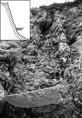
FIGURE 2. Location of the study sites “Dammkar” and “Tegelberg”
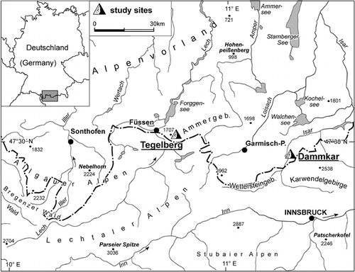
FIGURE 3. Rockfall registered at the collector “Kirchl 1”, 1995–1997. The width of the columns reflects the length of the respective service interval
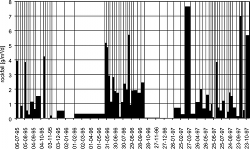
FIGURE 4. Rockfall at various test sites of the upper Dammkar area, 1995. Air temperature and precipitation measured at the meteorological station at 2200 m
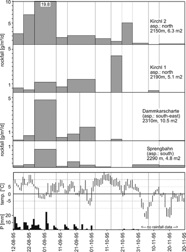
FIGURE 5. Rockfall at various test sites of the lower Dammkar area, 1997. Temperature measured at 1800 m, missing intervals interpolated from the meteorological stations at 2200 and 950 m. Precipitation measured at the Mittenwald station (950 m)
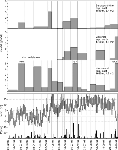
FIGURE 6. Mean removal rate of all collectors in the Tegelberg area, 2001 and 2002. Above the columns: mean temperature, minimum temperature and total amount of precipitation during the sampling intervals. “Front”: freeze-thaw activity with coincident precipitation. Inside the columns: number of test sites showing above-average rockfall (compared to total number of collectors)
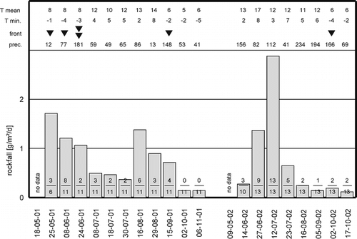
FIGURE 7. Long-term removal rates (nine years) at the test sites “Dammkarscharte” and “Kirchl 2”, Dammkar area. From 1998 to 2001, no separated summer and winter values are available
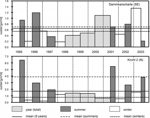
TABLE 1 Mean annual temperature and precipitation at various weather stations near the areas of investigation. Dammkar area: own measurements from 1995 to 1997, no precipitation data available for the winter months
TABLE 2 Percental distribution of the rockfall rates on different classes during various weather conditions. ↑: positive deviation (higher removal); ↓: negative deviation (lower removal); α: level of significance (chi2 test)
TABLE 3 Rates of rockwall retreat derived from measurements using netting or other kinds of rockfall collectors
Acknowledgments
I am obliged to DFG (Deutsche Forschungsgemeinschaft) for funding and to the cable car companies in the areas of investigation for their generous support. I am indebted to my supervisor, Prof. K. Rögner, for his trust and encouragement. Furthermore, I wish to thank Anthony Hornby and Chris Stearn for their corrections of the English, and the student assistants for their assistance in the field. The suggestions and helpful comments of Stephan Gruber on an earlier version of the manuscript are greatly appreciated.
Notes
Revised ms submitted February 2005
Related Research Data
References Cited
- Åkerman, H. J. 1983. Notes on talus morphology and processes in Spitsbergen. Geografiska Annaler 66A:267–84.
- André, M-F. 1997. Holocene rockwall retreat in Svalbard: a triple-rate evolution. Earth Surface Processes and Landforms 22:423–440.
- Becht, M. 1995. Untersuchungen zur aktuellen Reliefentwicklung in alpinen Einzugsgebieten. Münchener Geographische Abhandlungen, A47: 187 pp.
- Caine, T. N. 1976. The influence of snow and increased snowfall on contemporary geomorphic processes in alpine areas. In Steinoff, H. D., and Ives, J. D. (eds.), Ecological impacts of snowpack augmentation in the San Juan Mountains, Colorado. Fort Collins: Colorado State University, San Juan Ecology Project.
- Coutard, J-P. and B. Francou . 1989. Rock temperature measurements in two alpine environments: Implications for frost weathering. Arctic and Alpine Research 21:399–416.
- Douglas, G. R. 1980. Magnitude frequency study of rockfall in Co. Antrim, N-Ireland. Earth Surface Processes and Landforms 5:123–129.
- Fahey, B. D. and D. F. Dagesse . 1984. An experimental study of the effect of humidity and temperature variation on the granular disintegration of argillaceous carbonate rocks in cold climates. Arctic and Alpine Research 16:291–298.
- Fahey, B. D. and T. H. Lefebure . 1988. The freeze-thaw weathering regime at a section of the Niagara Escarpment on the Bruce Peninsula, southern Ontario, Canada. Earth Surface Processes and Landforms 13:293–304.
- Francou, B. 1982. Chutes de pierres et éboulisation dans les parois de l'étage périglaciaire. Revue de Géographie Alpine 70:279–300.
- Gardner, J. S. 1980. Frequency, magnitude, and spatial distribution of mountain rockfalls and rockslides in the Highwood Pass area, Alberta, Canada. In Coates, D. R., and Vitek, J. D. (eds.), Thresholds in Geomorphology. London: Allen & Unwin, 267–295.
- Gardner, J. S. 1983. Rockfall frequency and distribution in the Highwood Pass area, Canadian Rocky Mountains. Zeitschrift für Geomorphologie 27:311–324.
- Hall, K. 1988. A laboratory simulation of rock breakdown due to freeze-thaw in a maritime antarctic environment. Earth Surface Processes and Landforms 13:369–382.
- Hall, K. 1997. Rock temperatures and implications for cold region weathering, I: new data from Viking Valley, Alexander Island, Antarctica. Permafrost and Periglacial Processes 8:69–90.
- Hall, K. and M-F. André . 2001. New insight into rock weathering from high-frequency rock temperature data: an antarctic study of weathering by thermal stress. Geomorphology 41:23–35.
- Hall, K. and A. Hall . 1996. Weathering by wetting and drying: Some experimental results. Earth Surface Processes and Landforms 21:365–376.
- Hall, K. , C. E. Thorn , N. Matsuoka , and A. Prick . 2002. Weathering in cold regions: some thoughts and perspectives. Progress in Physical Geography 26:4 577–603.
- Ishikawa, M. , Y. Kurashige , and K. Hirakawa . 2004. Analysis of crack movement observed in an alpine bedrock cliff. Earth Surface Processes and Landforms 29:883–891.
- Lautridou, J-P. 1988. Recent advances in cryogenic weathering. In Clark, M. J. (ed.), Advances in periglacial geomorphology. New York: Wiley.
- Litvan, G. G. 1980. Freeze-thaw durability of porous building materials. American Society for Testing and Materials, Special Technical Publication 691: 455–463.
- Luckman, B. H. 1976. Rockfalls and rockfall inventory data: Some observations from Surprise Valley, Jasper National Park, Canada. Earth Surface Processes and Landforms 1:287–298.
- Matsuoka, N. 1990. The rate of bedrock weathering by frost action: Field measurements and a predictive model. Earth Surface Processes and Landforms 15:73–90.
- Matsuoka, N. 2001. Direct observation of frost wedging in alpine bedrock. Earth Surface Processes and Landforms 26:601–614.
- Matsuoka, N. and H. Sakai . 1999. Rockfall activity from an alpine cliff during thawing periods. Geomorphology 28:309–328.
- Matsuoka, N. , K. Morikawi , and K. Hirakawa . 1996. Field experiments on physical weathering and wind erosion in an antarctic cold desert. Earth Surface Processes and Landforms 21:687–699.
- McGreevy, J. P. and W. B. Whalley . 1985. Rock moisture content and frost weathering under natural and experimental condition: A comparative discussion. Arctic and Alpine Research 17:337–346.
- Nyberg, R. 1991. Geomorphic processes at snowpatch sites in the Abisko Mountains, northern Sweden. Zeitschrift für Geomorphologie 35:321–343.
- Prick, A. 1997. Critical degree of saturation as a threshold moisture level in frost weathering of limestones. Permafrost and Periglacial Processes 8:91–99.
- Rapp, A. 1960. Recent development of mountain slopes in Kärkevagge and surroundings, northern Scandinavia. Geografiska Annaler 42:65–201.
- Sass, O. 1998. Die Steuerung von Steinschlagmenge und -verteilung durch Mikroklima, Gesteinsfeuchte und Gesteinseigenschaften im westlichen Karwendelgebirge (Bayerische Alpen). Münchener Geographische Abhandlungen B29, 175 pp.
- Sass, O. 2004. Rock moisture fluctuations during freeze-thaw cycles—preliminary results derived from electrical resistivity measurements. Polar Geography 28:1 13–31.
- Sass, O. 2005a. Spatial patterns of rockfall intensity in the northern Alps. Zeitschrift für Geomorphologie Suppl., Vol. 138:51–65.
- Sass, O. 2005b. Rock moisture measurements: techniques, results, and implications for weathering. Earth Surface Processes and Landforms, . 30:347–359.
- Sass, O. and K. Wollny . 2001. Investigations regarding alpine talus slopes using ground penetrating radar (GPR) in the Bavarian Alps, Germany. Earth Surface Processes and Landforms 26:10 1071–1086.
- Thorn, C. E. , R. G. Darmody , J. C. Dixon , and P. Schlyter . 2001. The chemical weathering regime of Kärkevagge, arctic-alpine Sweden. Geomorphology 41:37–52.
- Tricart, J. 1956. Etude expérimentale du problème de la gélivation. Biuletyn Peryglacjalny 4:285–318.
- Vorndran, E. 1969. Untersuchungen über Schuttentstehung und Ablagerungsformen in der Hochregion der Silvretta (Ostalpen). Schriften des Geographischen Instituts der Universität Kiel 29, 140 pp.
- Walder, J. S. and B. Hallet . 1986. The physical basis of frost weathering: Toward a more fundamental and unified perspective. Arctic and Alpine Research 18:27–32.
- Wiman, S. 1963. A preliminary study of experimental frost weathering. Geografiska Annaler 45:113–121.