
Abstract
Recent literature has demonstrated the importance of fieldwork in geology. However, as resources become scarce, field experiences are often targeted for cuts. This was the case at the University of Calgary when massive enrollments placed a tremendous burden on resources. In courses throughout, field trips and other excursions were eliminated, making it so students do not have any field experiences until their third year. In response, we have developed three virtual field experiences (VFEs) of geologically relevant locations near Calgary. A burgeoning technology, VFEs offer advantages of convenience and versatility when compared to actual field trips. Our VFEs comprise drone-captured images used to form high-resolution 2-D photomosaics and 3-D computer models. We piloted one VFE in an introductory geology course. We wanted to understand how students engaged with the models so that we could make the VFE as effective as possible. Observing student engagement over two iterations allowed us to make changes to the activity. We found that students had difficulties with the VFE’s open endedness. They also demonstrated difficulty with the relationship between observations and inferences. This is indicative of a broader issue with how geology (or science in general) is taught. Traditional instruction in geology places great emphasis on the “what” of geology as opposed to the “how.” We contend that teaching geology with more emphasis on how geology works will help students develop a better understanding of the relationship between inference and observation, enhancing their fieldwork and their understanding of science.
Introduction
From the earliest days of geology, investigating the processes on Earth happened largely in the field. In fact, field observations have played a role in many of the “big ideas” concerning how we understand Earth—from the designation of eons, periods, and epochs of the geologic time scale (Rudwick, Citation1985), to the historical nature of Earth (Cutler, Citation2003; Rudwick, Citation2014), to the idea of deep time (Repcheck, Citation2003; Şengör, Citation2001), and finally to the development of a consensus view concerning the dynamics of Earth: the theory of plate tectonics (Frankel, Citation2012; Glen, Citation1982; Oreskes, Citation1999; Oreskes & LeGrand, Citation2001). Furthermore, some evidence supports that students learn more effectively about Earth through engaging in fieldwork (Elkins & Elkins, Citation2007). More recently, although much investigation takes place in the lab, it is typical for queries to end in students heading back out into the field to collect samples, test predictions, develop initial interpretations, or garner more evidence to support an earlier interpretation. According to most geologists, “the field” is an indispensable part of teaching and learning in the discipline of geology (Petcovic, Stokes, & Caulkins, Citation2014). Mogk and Goodwin (Citation2012) summarized that fieldwork helps students learn how geology is done through embodied experiences, develop inscriptions—artifacts of the data collection and management derived from fieldwork—and get socialized into the community of practicing geologists.
It makes sense within such a learning context that geoscience departments maintain, as a staple of their programs, at least one and often multiple field courses or field schools (Drummond & Markin, Citation2008). Field school is traditionally a multiweek course involving a small class of students (20 to 40) who travel to areas of geologic interest to spend time observing and ideally interpreting geologic features, usually by developing maps with associated cross-sections. It is an indispensable part of a student’s socialization into the community of geoscientists. Short, class-based field excursions also typify geoscience programs, in which the instructor might take a class on a multistop trip, from a few hours to a couple of days, to see aspects of the local geology pertinent to the course work. This supplementary work helps students have embodied and situated experiences (Hutchins & Renner, Citation2012) and develop visual-spatial skills (Hutchins & Renner, Citation2012; Kastens & Ishikawa, Citation2006) important for doing geology. A geophysics class may also incorporate lab- or field-based activities using a particular instrument (e.g., radar, gravimeter) to measure variations in material properties, and then discuss potential limitations in the measurements that aid interpretations of the data. With both types of activities, developing that capacity to make logical conclusions that flow from the available data is a key focus of the learning experience.
Taking a group of students on a trip away from their college or university campus presents many challenges, however; so much so that in some cases these peak learning opportunities are out of reach. Challenges include the logistics of finding time to spend out in the field, transporting students from the campus to the field, and creating an experience that maximizes achievement of course learning goals while not becoming an event that students perceive as simply time away from academic learning. Another hurdle can be as mundane as class sizes. As an example, over the past decade our introductory geology course has climbed from about 100 students in its first year of 2007 to just over 400 students in 2017, with a peak of over 500 students in 2013. With this increased student load, maintaining quality learning experiences for students has placed undue stress on the department’s resources, with the unfortunate casualty being class field trips. Taking 500 students out to a road-cut and expecting useful learning to occur is unreasonable (apart from the obvious transportation, resources, and safety considerations for such a large group). Thus, geology students in our department do not get an actual field experience until they start their third year, when they take the mandatory field school that has also been altered to accommodate the burgeoning student numbers. This article discusses one viable way to fill this gap: virtual field experiences (VFEs).
VFEs are the result of collecting, curating, compiling, and processing visual data from a geologic location of interest, and provide the means to augment students’ field experiences within the confines of the allotted resources. In the introductory geology course, we created a number of VFEs that were integrated into students’ scheduled lab time. The design of the VFEs allows students to explore a location and use the image data to help answer questions posed by the lab. VFEs are intended to help novice students begin to develop some process skills that are emphasized in field school while also encouraging upper-level students to further practice such skills as making inferential claims based on data and reaching some understandings of general content material. Our goal with this article is to describe our process in implementing a new teaching tool by observing student interactions with that tool and revising and reimplementing it in light of those observations. Specifically, we wanted to answer these questions: How do introductory geology students approach and manage the tasks of the VFE? And what are the implications of these data for future iterations of VFE implementation? We will also make some guiding generalizations based on those observations.
Review of the literature
In tandem with the rapidly developing digital technology useful for scientific inquiry is the growing popularity of virtual field experiences or virtual field trips. Many software programs have been generated for creating digital images: ArcGIS, Google Earth, and Prezi, among others, are being used as platforms for housing this digital data.Footnote1 This has allowed many instructors to create such activities for their students; further, many different kinds of VFEs exist. Some are highly structured, with a specific sequence of designated “stops” at each site, along with text describing the geology of that particular location. Others allow students the freedom to process data derived from locations of interest within the data at their own pace and inclination. The VFEs our group designed are considerably more open ended, with few designations of points of interest to attract students’ attention. Instead, they actually display the data en masse. This affords students the freedom to pan and zoom where they wish as they try to make sense of the data, as if they had been left in the field with limited background information about the area (e.g., topographic maps, surface geology maps, or rock samples) and they had to explore and interpret it themselves. Although VFEs have become more prevalent in instruction, few researchers have studied their efficacy. Most of the published information about VFEs focuses on rationales for instituting such activities in class, as well as accounts of the advantages and disadvantages of incorporating VFEs in instruction.
What the VFEs afford
There are many reasons why instructors have chosen to create and implement VFEs in their courses. With ever-tightening budgets, many have seen the VFE as a way to avoid the cost of field excursions (Jacobson, Militello, & Baveye, Citation2009; Litherland & Stott, Citation2012). Also, increasingly, educators are aware of creating a more inclusive classroom environment. Fieldwork, by its nature, can pose obstacles to some, especially those with mobility constraints. Thus, the VFE can be a way to level the field, so to speak, for those who would otherwise have trouble navigating it (Atchison, Citation2011; Stainfield, Fisher, Ford, & Solem, Citation2000). Boyle et al. (Citation2007) and Litherland and Stott (Citation2012) also pointed out that the predictable classroom location of the VFE activities can mitigate the anxiety some students (especially novices) feel about investigating in the field. These various factors therefore can open up the number of students who actually participate in the VFE, which in turn increases the intellectual talent involved in the investigation (Gilley, Atchison, Feig, & Stokes, Citation2015).
Not only does the incorporation of the VFEs into course instruction help increase accessibility for students in lieu of actual fieldwork, they can also use it to supplement fieldwork that does take place within the course (Litherland & Stott, Citation2012; Peat & Taylor, Citation2005). Hesthammer and colleagues (2002) found that VFEs helped to give students an overview of the fieldwork to be done. Others have found that VFEs are also useful in providing previews and reviews of fieldwork (Çaliskan, Citation2011), and they can give structure to postfieldwork activities (Bentley, Citation2014).
Whether VFEs are used to supplement fieldwork or to fill the need for fieldwork, many instructors have expressed the advantages of incorporating this type of instructional strategy into their courses. For instance, students have a great deal more freedom to explore with a VFE than with traditional fieldwork. They can work at their own pace (Arrowsmith, Counihan, & McGreevy, Citation2005; Fletcher, France, Moore, & Robinson, Citation2002), revisit locations as often as necessary (Hurst, Citation1998), and manage their time better, as there are fewer time constraints and more overall flexibility. In addition, physical barriers in the field no longer present impediments (Arrowsmith et al., Citation2005). Other logistical barriers—such as poor weather conditions, access to food, transportation issues, and directions to the site—also become nonissues with the VFE. Finally, the versatility of the models helps students develop a better idea of scale (Bailey, Whitmeyer, & DePoar, Citation2012), as well as giving them opportunities to develop understanding of the physical processes occurring within the context of the VFE (Li & Liu, Citation2003).
We want to point out that experiences in the field are superior for students compared to experiences with the VFEs. The VFE is a reasonable alternative when resources are otherwise strained. Also, due its novelty in structure, the VFE could be a source of greater engagement for students. Nonetheless, as with any model, some authors using VFEs in instruction have pointed out some significant limitations.
The limitations of VFEs
The literature reveals only a few reported limitations to consider when implementing VFE-type activities in class. The predominant concern is that VFE activities cannot reproduce the collaborative/social interactions that would occur in the field (Bailey et al., Citation2012; Çaliskan, Citation2011; Stumpf, Douglass, & Dorn, Citation2008), and thus instructors need to be explicit about emphasizing teamwork (Arrowsmith et al., Citation2005). The second noted limitation is that the VFE is not able to reproduce other actual sensations that students would experience in the field—for example, smells, sounds, and the sensation of the body in that particular space (Hurst, Citation1998). These types of experiences are rarely given much consideration, but recent investigations into the embodied nature of the mind (Clark, Citation2011; Hutchins & Renner, Citation2012; Lakoff & Johnson, Citation1999; Shapiro, Citation2011) tell us that a great deal of student thinking and learning takes place through modes other than just the visual.
As the previous section demonstrates, incorporating VFEs into instruction has several benefits for students; however, we still know little about how the learning that takes place when students engage in such activities compares to that which takes place during real field activities. Litherland and Stott (Citation2012) reported increased participation in classes when VFEs were implemented, and Clary and Wandersee (Citation2010) noted that students self-reported that VFEs had enhanced their learning of the course work. When actually measuring knowledge gains, Stumpf et al. (Citation2008) found these to be similar between virtual and actual field experiences, whereas Stott and Nuttall (Citation2010) reported that students did not develop better understandings after a VFE than they did through actual fieldwork. Given the limited research to date on VFEs, these findings are promising, as they suggest that the use of virtual fieldwork—in place of actual fieldwork—achieves at least similar learning outcomes.
Our theoretical framework for VFE development
According to the National Research Council (Citation2006, p. 195), the goals of laboratory experiences (this could be in lab or field experiences) are multifaceted. These include:
enhancing mastery of subject matter,
developing scientific reasoning,
understanding the complexity and ambiguity of empirical work,
developing practical skills understanding the nature of science,
cultivating interest in science and in learning science, and
developing teamwork abilities.
In general, we wanted to create an activity that addressed as many skills associated with fieldwork as possible (e.g., Mogk & Goodwin, Citation2012), with the understanding that although we might not be able to address all of these skills, our activity would be an improvement relative to the current student experience. Skills we considered transferrable to the VFE platform included the iterative or hermeneutic analysis and interpretation of data, temporal and spatial visualization (being able to see what a geologist sees), and working in a community of geoscientists.
As Frodeman (Citation1995) described, geology is a historical and interpretive science. Geologists observe the environment, record observations from the rocks or landscape, and interpret them in the process of constructing a history responsible for those observed phenomena. Part of our motivation was to provide this experience to students without needing to enter the field. The VFE allows students to explore the terrain at various scales and offers some structural components, allowing for the interpretation and development of a geologic story for the field site. This type of activity would also help students hone their visual-spatial (Kastens & Ishikawa, Citation2006) and temporal reasoning skills (Dodick & Orion, Citation2003, Citation2006).
Multiple sketching activities were incorporated into the VFE in order to facilitate improvement in visual-spatial reasoning. Mogk and Goodwin (Citation2012, p. 145) noted, “the field setting is where geoscientists initially translate nature into culture, i.e., where we begin to create representations based on communally tested and accepted practices (i.e., maps, graphs, visualizations) that explain, confirm, rationalize, and externalize our understanding of Earth.” In our VFE, students had the opportunity to sketch the entire field site as well as any points of interest to them. In addition to the orthomosaic of the expanse of Mount Yamnuska, we included one important area of the field site as an inset image with higher resolution. This inset was an exposure of the McConnell Thrust Fault, which forced Paleozoic limestones over the top of Mesozoic fluvial sandstones. The intent with this inset was to encourage students to start separating useful data from “noise” in a virtual field setting, to start seeing what a geologist sees. This would be a first step in introducing students to the hermeneutic process of geology (Frodeman, Citation1995). Students retrieve data, start to formulate a hypothesis for the problem, and go back to look at the field again with “new eyes” influenced by the hypothesis or multiple working hypotheses (Chamberlin, Citation1965/1890). New data might then affect the initial hypothesis, subsequently changing the nature of data from the site, and on, and on.
Mogk and Goodwin (Citation2012, p. 149) also pointed out the sociocultural benefits of doing fieldwork that we hoped to encourage with our VFEs. Socialization into a community of practice includes examples of “language translated into practice, tools used to acquire organize and advance community knowledge, shared ethics and values, and collective understanding of limits and uncertainties.” In this vein, students were encouraged to explore the VFE field site in groups, discriminating data from noise and coming to understand the limits of interpretation as that interpretation developed over time. Such skills are not the focus in classrooms and lecture halls.
Where our VFE does not overlap well with the goals of fieldwork as outlined in Mogk and Goodwin (Citation2012) is the embodied experience of fieldwork compared to the lab setting and virtual landscape of the VFE. Mogk and Goodwin asserted that “[s]trong sensory inputs associated with immersion in a physical field setting are ascribed to impacts on the affective domain, which in turn, are strongly coupled with cognitive memory functions” (2012, p. 135). The idea is that the act of simply being in the field—scrambling over rocks, smelling the fragrances of the outdoors, and hearing the sounds of nature—is connected to the actual science in which the students are partaking. This, of course, is not happening in our laboratory experiences. However, although these experiences are not available first hand, there is the possibility the VFE could evoke the memories of such experiences in students who have them through a “cascade of associations” (Kahneman, Citation2011) or “experiential gestalt” (Lakoff & Johnson, Citation1999), thereby maintaining a connection between the lab and the natural environment.
In our initial research, we did not aim to measure knowledge gains of students as a result of engaging in the VFE. Our main priorities were instead to explore how the students actually approached the tasks asked of them during the VFE, and to use that information as a way to enhance the design of the VFE and increase its efficacy. Below, we report on two successive implementations of the Mount Yamnuska VFE (see description below) in a large-enrollment (n ≈ 400 students), introductory geology class for science majors.
Methods and findings
Picking locations of geologic interest
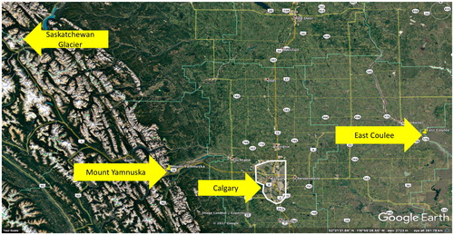
When considering which locations would be ideal for making the VFEs, we were not short on possibilities. With our location, near the Canadian Rocky Mountains to the west and the badlands of southern Alberta to the east, we could choose between several locations with regional relevance that would generate considerable student engagement. We also had as a secondary goal that the VFEs be infused with sufficient detailed data that they might become inquiry projects in more upper-level geoscience classes, in addition to the introductory classes that were our immediate focus. This would allow upper-level students to see the same sites but through different lenses, as they encountered them in additional courses (for instance, surficial geology, sedimentology, or structural geology). We picked three locations: Mount Yamnuska, the Saskatchewan Glacier (part of the Columbia Icefields on the border between Banff and Jasper National Parks), and an outcrop in East Coulee, near Drumheller, Alberta ().
Figure 1. Google Earth image of Calgary, Alberta, with the three VFE sites (Mount Yamnuska, Saskatchewan Glacier, and East Coulee) highlighted. The width of the image represents approximately 370 kilometers.
Mount Yamnuska
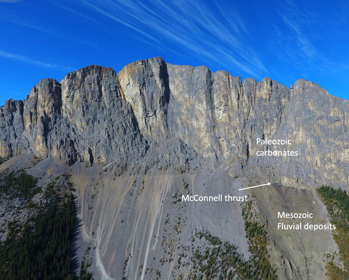
Driving west from the city of Calgary on the Trans-Canada Highway, Mount Yamnuska () is the first peak as one enters the Front Ranges. From the highway, Yamnuska displays an approximately 500 m vertical cliff face and is about 2.5 km across. The cliffs are made up of Paleozoic limestones, which sit on Mesozoic fluvial sandstones. We picked this location because it is familiar to the majority of the students, but also because of this chronological anomaly of older rocks sitting atop younger rocks. The contact between the two rock units (the McConnell Thrust) is visible along some of the base of the cliff face. Site access is relatively easy, as it is a 45-minute drive (approximately) west from Calgary, followed by a two- to four-hour round-trip hike to the base of the escarpment, where the fault contact is visible. We saw the accessibility of the site as a positive feature, as students could visit it on their own after completing the VFE to reinforce their learning and build on their understanding of the site.
Figure 2. Photomosiaic of Mount Yamnuska showing Paleozoic cliff-forming carbonate rocks overlying Mesozoic fluvial sandstones, forming the slope beneath the cliff. The McConnell Thrust Fault trace is visible at the base of the cliff toward the right, middle of the photograph, to just before the tree coverage starts.
Saskatchewan Glacier
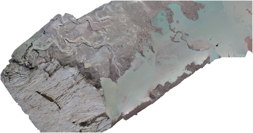
The Saskatchewan Glacier () is located approximately a four-hour drive north and west of Calgary on the Icefields Parkway through Banff National Park. It is one of eight major glaciers that make up the Columbia Icefields. The surrounding mountains are mainly Paleozoic carbonates and create impressive relief all through this area. The location is visually stunning. We picked it because of its visual appeal, but also because some wonderful surficial geology features—both glacial and fluvial—are visible with the active melting of the glacier, which students can focus on during their engagement with the VFE. Although it is a longer drive from Calgary than Yamnuska and access is more challenging, it can still be considered a site of local interest.
Figure 3. The toe of the Saskatchewan Glacier (left) showing meltwaters running from the glaciers into the adjacent lake. The valley width is approximately 270 meters across.
East Coulee
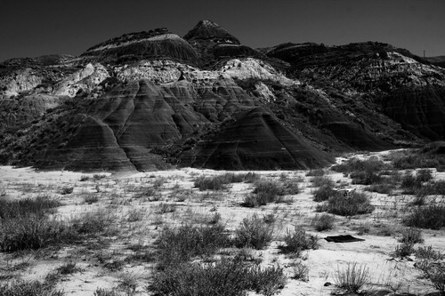
The badlands of the Red Deer River Valley are a two-hour drive to the east of Calgary, where ice and melt water from the last glacial maximum have carved through the overlying glacial sediments into the flat-lying Mesozoic strata, which include fluvial sands and silts, volcanic ash beds, tongues of marine shale, and plenty of dinosaur fossils. East Coulee () is just minutes outside of Drumheller, the home of the Royal Tyrrell Museum of Palaeontology. The museum is famous for its dinosaur collection, which breathed life back into the old coal-mining town; it would be well known to many of our geoscience students. In addition to name recognition, we picked this site because of its relatively simple stratigraphy.
Figure 4. Image of the outcrop at East Coulee. Note the characteristic “bad lands” topography as well as the regular sedimentary layering.
Collecting, compiling, and curating VFE data
We had originally planned to collect digital imagery in a number of different modes, such as GigaPan photos and 360-degree stitched photos, but eventually we decided to use the expertise of Automated Aeronautics, which operates unmanned aerial vehicles, or drones, with attached cameras. The data collected by Automated Aeronautics produced a far superior product for what we were looking to do than our first plan. With their setup, we were able to capture thousands of georeferenced images of each site of interest that could later be assembled into large photo mosaics, and also three-dimensional computer models.
Once the data were gathered in each location (Mount Yamnuska in August 2016; East Coulee and Saskatchewan Glacier in July 2017), V-GEO Tours (a subsidiary of Automated Aeronautics) processed the data and built the photo mosaics and the three-dimensional models.Footnote2 We piloted the Mount Yamnuska VFE with students first, as it was the first for which we collected data. In building the VFE and associated tasks for students, we relied on a recent report about how to structure effective laboratories for science classes. The National Research Council (Citation2006), in its executive summary of this report on laboratory work in U.S. high schools, made four recommendations to educators for producing effective laboratory experiences:
Maintain clear learning outcomes.
Sequence laboratories to follow course instruction.
Emphasize learning content along with scientific processes.
Incorporate enough student reflection and discussion.
The learning outcomes we sought to emphasize were more oriented to process than content. We wanted students to develop a strategy for approaching the field—specifically, how to scan the location for significant features and how to use the zoom-in/out tool to begin building their “big picture” by using smaller sections of focus. We wanted them to develop an iterative approach, moving between the big picture and the details; between inferences and observations; between theory and data. We implemented the VFE as the last lab of the fall 2016 term to take advantage of students having been exposed to the most geologic information by that point in the course content. This would give them the best chance of identifying the most salient portions of the VFE and thus interpreting them accurately. We developed the VFE to fit within the students’ three-hour weekly lab period.
In contrast to many available virtual field trips that highlight specific points of interest and give an expert’s interpretation, we thought it important to emphasize a more inquiry-based approach. Inquiry, in a science education context, is a messy term with about as many definitions as there are definers. The idea we had in mind most closely resembles that of Bybee (Citation2006), in that we interpret inquiry as:
engaging the learner in scientifically oriented questions,
prioritizing evidence in support of an explanation,
connecting knowledge with the broader scientific base, and
encouraging students to communicate/argue their explanations to others.
With this in mind, instead of identifying all the places of interest in the VFE and pointing students to them for interpretation, we chose to leave the photo mosaic open and free of any annotations that would direct students about what to look at and how to interpret it. We wanted students to approach the VFE as if they were walking into the field for the first time, looking for their own points of geologic interest and making their own interpretations, based on what they had learned in the course so far. This is similar to the field school experience they will have when they reach that milestone. We encouraged students to work in groups of two to four, so they might rely on each other during the interpretation of the data, thereby leveraging the potential benefits of teamwork and social interaction.
Pilot implementation
Due to the number of students in the course (about 400), there were approximately 20 lab sections of 20 students run every week. Prior to the lab implementation, students downloaded Google Earth onto their computers and printed out the lab sheet (see Supplemental file) with the instructions and questions. During the lab, they downloaded the Mount Yamnuska photo mosaic, saved as a .kmz file, into Google Earth. This placed the photo mosaic onto the landscape in Google Earth, so they could see it in the context of the surrounding topography. To understand how the students were experiencing the VFE, we asked for volunteers who would be willing to be observed during the implementation. One of the authors acted as participant observer and took field notes while observing two different groups of students engaged in the VFE. We also gathered observational data and reported perceptions of the graduate teaching assistants (GTAs) of each of the 24 different lab sections. We did not give the GTAs any special training for implementing the VFE, except for the technical portion for how to get the .kmz file into Google Earth. We did tell the GTAs that the emphasis was on geologic process and not product, so they were to limit the amount of direction they might give students. They were to answer student questions not by pointing out the answer but by turning the question back on them; have it be their investigation.
Student population of GLGY 201, 2016, and 2017
GLGY 201 is an introductory geology course and draws students from the entire campus. In 2016, there were 387 students enrolled, of them, 54% were female, 58% came from the faculty of science—the vast majority of whom were biological science majors, and 10% geoscience majors—32% came from the faculty of arts, almost 5% from business, and the last 5% from various other faculties. The average age of the students was 20.2 years. The vast majority classified themselves as Canadian residents (94%). The demographics of the 2017 cohort are very similar to 2016, although the total number of students was down by 60 students (327) from the previous year. There were 56% female students. The majority of students, again, came from the faculty of science (52%), followed by the faculty of arts (38%), business (5%), and other (5%). The average age of the students (20.1) was also similar to the previous year. Again, the vast majority of students claimed Canadian residency (94%). Although most students claimed Canadian residency, they did identify as citizens from 44 different countries.
Researcher observations
The following summarizes our findings from direct observation of student groups by the project principle investigators (PIs). We found that the students had difficulties with the open-ended nature of the VFE, and also demonstrated other, broader study issues.
Students struggled with what constitutes good field notes. They were much more concerned with the precision of their sketches than more fundamental relationships among formations, so they often spent up to an hour creating, tracing, erasing, and recreating their initial sketch of the field site—to make it “just like” the photo. One participant stated, “I wish I had taken an art class.”
Students appeared to feel compelled to use technical vocabulary, but their usage was often incorrect. For instance, one of the participants, when trying to identify the type of rock presenting on the upper portion of Mt. Yamnuska, said, “I’m going to go with metamorphic because the rocks are inconsistent.” When discussing some apparent linear features in the rock face, one student asked, “Would that be a horizontal bedding or a vertical bedding? Would that be a bedding? A striation?” Here students observed light colored portions of the cliff face in a vertical orientation with darker colored rock between the lighter colored rock vertically bedded. In the photo, the color difference was really an artifact of weathering, as all the rock was a bedded (10s centimeter to meter thick) limestone with a slight dip to the southwest. As this vocabulary was quite new to them, it was not surprising perhaps that their understanding was not comparable to expert understanding. Unfortunately, this lack of clarity did slow their progress considerably: Although ostensibly they used a common language, their definitions often actually differed and so they frequently talked past each other. In several instances, they tried to impose a concept onto the image based on the vocabulary they thought was relevant, and then proceeded to shoehorn the data into that concept (a top-down approach), as opposed to developing descriptions from the relationships in their observations (a bottom-up approach). In another example, a pair of students decided that the color difference between the rocks in the upper carbonate unit indicated an igneous intrusion where the darker rock had intruded into the lighter rock. One had reasoned that, “Since intrusions cause deformed strata, the light grey rocks must be deformed strata.”
Students did not use the ability to zoom in and out of the data to develop their understanding iteratively, as was the goal. One big advantage of this VFE over actual fieldwork is that it allows the students to see the whole picture at once and then, in seconds, zoom in to observe detailed structures, going from a 2.5 km mountain face to viewing structures on a decimeter scale. It was our hope that students would pick out places of geologic interest when viewing the entire mountain, and then investigate these areas of interest by zooming in, making observations, and then viewing them again within the context of the whole picture by zooming out once more. Our expectation was that they would develop an understanding about the need for such an iterative approach to fieldwork. However, the students we observed rarely took advantage of this feature, even after having it demonstrated. Forty minutes into the first observation, the observer made the following note: “There is not much zooming in or out going on.” Thirty minutes later, the same observer noted, “Is there any way to emphasize [in the second implementation] iterations/zoom in and out?”
Students had difficulty picking out the geologically relevant data from the overall picture. Students were very interested in the shapes along the ridge of the Mount Yamnuska, erosional gullies (strong vertical features) where vegetation was growing, and the shapes of the talus slopes. As pointed out earlier, some students identified layers but then attributed them to metamorphism and did not choose to explore the nature of the layers any further.
GTAs’ general comments
We had 20 GTAs to manage 24 lab sections for this course. The week after the implementation at our regular weekly meeting, we discussed the GTAs’ comments about the implementation of the VFE. The following represent the most salient points from the perspective of the GTAs, concerning what they observed and how they might approach improving the VFE in light of these observations.
Students had trouble with the idea of taking “field notes.” This was similar to our observations about students taking an overly long time to generate sketches that were precise to the photo but did not demonstrate enhanced understanding of the site from the interpretation of features. Students did not see the activities to help them develop field notes as a way to express what they observed, emphasizing particular aspects of the site in a way that they might learn from it. Rather, they wanted the field notes to be only a record, like a photograph, reflecting everything and giving each aspect equal weight.
Students could have used the hand samples of the rocks available on the VFE to aid their identification of the rock samples, but they did not choose to do so. Although they had been exposed to the various kinds of rocks and had some experience with hand samples in their labs, to see actual samples of these rocks displayed on their computer screen would have helped to shift their abstract understanding of the visual model toward something more concrete. It might have also helped students who had identified the carbonates as metamorphic rocks to consider alternatives to that interpretation upon viewing hand samples up close.
The geologic map overlay on Google Earth was insufficient and confusing. To help students grasp some of the context of the geology of the area (and the fact that there were Paleozoic rocks sitting on top of Mesozoic rocks), we also placed an overlay in Google Earth of a surficial geology map. However, the map was not of a fine enough resolution to provide unambiguous information about the ages of the rocks under investigation.
Some questions asked on the VFE concerned concepts not yet covered in the lecture or lab. Because the structural geology topic (dealing particularly with faulting and folding of rocks) was the last topic presented in the lecture portion of the course, students did not have some of the requisite background necessary for developing reliable explanations for why Mount Yamnuska looks the way it does. This caused issues, especially as the major feature of the site is the thrust fault that placed the Paleozoic carbonates on top of the Mesozoic sandstones.
Open-ended questions gave students some difficulty. Many of the labs leading up to this one were structured, with clear direction, and relied on closed questions for which a definite, correct answer existed. In fact, according to research on school science labs, many laboratory activities could also be classified in the same manner (National Research Council, Citation2006). In contrast, the questions students responded to in the VFE were more open in character, with various possible answers. Because no single correct answer was sought—but rather, responses based on the students’ observations—GTAs noticed that students were hesitant to record their answers for fear of not having the correct one.
The “big picture” aspect of the VFE—seeing everything all at once—seemed to overwhelm the students, according to the GTAs. This may be because, as described, students had difficulties taking advantage of the zoom in/out feature of the VFE, and they did not identify the geologically significant aspects of the VFE. With the view of the entire mountain at once, perhaps they experienced it as more than they could consider at once, not recognizing that they could break the site down into chunks that would have made interpretation more manageable. Indeed, Çaliskan (Citation2011) noted that students with too much freedom become overwhelmed and cannot manage the whole site, or possibly just focus on one aspect to the exclusion of the rest. Either way, students do not develop a whole picture understanding of the field site, because they are not considering the whole picture.
Redesign
Given these observations, we modified the VFE and its implementation to improve its effectiveness, in the hope that this would give students more tools and therefore more confidence. We made three key changes, in the following order:
We instituted a short lab activity the week prior to the second VFE implementation. We called the activity “What a geologist sees,” using images pulled from the internet of road cuts and other outcrops with very distinctive geologically significant structures exposed: faults, folds, dune cross stratification, and so forth (see Supplemental file). The scaffolding process entailed three steps:
Students viewed each image, one at a time, and spent several minutes making a sketch of what they observed. We directed them to look for patterns and changes in patterns, abrupt changes in color, obvious breaks or folds in layers, and so on.
Once their sketches and notations were complete, students then saw another image of the same outcrop with white markings drawn onto it, to point out the geologically relevant structures—in other words, what a geologist would see.
Finally, students were shown a third image for each outcrop that did not include the original digital image of the outcrop, but just the markings (now black on a white background) to model for them a sketch on a piece of note paper.
Students completed six drawings with this process, and then three more sketches from just the outcrop images, with no other scaffolding provided.
We included hand samples of the rocks seen in the VFE. Unfortunately, we were unable to acquire actual rocks from Mount Yamnuska because the site is located within the boundaries of Kananaskis Provincial Park and we could not procure permits to collect samples within the park prior to the VFE implementation.Footnote3 However, the specimens used were deemed sufficiently similar to native Yamnuska rock to be useful diagnostic tools. Students were able to test for the presence of calcite with hydrochloric acid, as well as examine the hand samples for the presence of fossils, sediment and mineral compositions, and other diagnostic properties.
We asked the GTAs to do several specific things with the students:
Remind them as often as they thought necessary that they could zoom in and zoom out of the photomosaic to make their observations and interpretations.
Encourage them to construct their overall diagrams so that their detailed diagrams were displayed as a small piece located within a larger diagram of the mountain.
Ask student groups to (a) describe how the feature they were focused on looked if they zoomed in, and (b) how it might fit into the rest of the site if they zoomed out.
Second iteration implementation
We implemented the second Mount Yamnuska VFE in the fall of 2017, again as the last lab of the term. Unfortunately, the lecture material had once again not yet reached the structural geology topic. However, students were given the opportunity to read ahead, with the lab sheet stating that information from the chapter (pertinent pages in the textbook were given) could help them in interpreting the observations they would have made during engagement with the VFE. This time we had more observational data than during the pilot implementation because (a) many more student volunteers were available to be observe, and (b) two of the project PIs and a graduate research assistant were available to make multiple observations each. These data follow.
Researcher observations
All three observers noted that participants were very concerned with the drawing aspect of the assignment. They were more interested in a precise recreation of the outcrop, spending 30 to 60 minutes developing the overview sketch. In addition to getting the shape of the ridge just right, they also spent a lot of time placing and drawing the vegetation, trees in particular. From these observations, it seems that the prior lab (“What a geologist sees”) might not have been enough experience for the students to understand how to create succinct field notes. Furthermore, students were heard to say that they did not understand why they were making the sketches, which may be a clue as to why they appeared to have difficulties with sketching task. Certainly, if they did not know why they needed to collect data, they would not know what data they should collect. This point will continue to be prevalent in the other observations and may actually be reflective of a larger, structural issue in instruction.
Observers also reported that many of the groups were quick to settle on a classification of metamorphic for the cliff-forming unit of Mount Yamnuska. They noted the irregular and tilted layers or “deformed strata” as foliation; once they made this designation, they placed all other observations into that classification. They talked about how burial would have caused the irregular layers. Also, when they tested the hand samples with hydrochloric acid, which did react strongly, they identified them as marble. In other words, with their interpretation (“the answer”) already established, they proceeded to justify it by forcing their other observations to align with that interpretation.
In addition to this behavior—of settling on an interpretation early and then adjusting their observations to conform to that context—students also seemed to miss the connection between observations and inferences. Students used hydrochloric acid to test if rock samples reacted, but then did not use this information to inform their interpretations. They sketched the various parts of the outcrop but did not understand why the diagrams were important. They used descriptive terminology (for instance, deformed strata), but did not incorporate this into their overall interpretation (metamorphic rocks). Using the provincial geological map overlay on Google Earth that was also part of the VFE, they discovered that there was a sequence of older rocks sitting on top of a sequence of younger rocks, but similarly they did not integrate this observation into their explanations about what was happening.
In contrast to this general report from the GTAs and two of the three investigators, the third investigator (a coauthor) did observe students being more iterative in their approach of using data to form and reform hypotheses. As he recorded in his field notes:
Observed students initially developed a hypothesis that the rocks on the upper part of the outcrop were metamorphic. This hypothesis only incorporated observations of the digital image of the outcrop, which does not allow one to distinguish between “layering” of sedimentary rock and “foliation” of metamorphic rock. Students only observed roughly horizontal patterns but were not able to make the correct interpretation. Later, in discussion with a teaching assistant, a student commented:
“I am wondering if I am on the right track. Don’t look at this [covers writing and sketch about metamorphic rocks]. Would the mountain have formed by deposition and compression over time in the ocean to form limestone?”
The observer asked why the student had reconsidered their rock identification, to which they responded:
“Well, we noticed that the rock [hand sample] reacted with HCl, so the most basic rock type we know that reacts with HCl is limestone, and it makes sense with the layering since it is an accumulation of shells and things. And maybe this sediment at the bottom [fault contact] is from wave action in the past on the ocean floor. That’s our basic hypothesis.”
It is clear that, although the students have not made an entirely correct interpretation at this point, they are using newly acquired data to revise their working hypothesis in an iterative fashion.
Students did seem to be influenced by the ability to zoom in and out of the photomosaic. Many noted the vertical erosional features running the height of the cliff face. Once reminded to take advantage of the ability to zoom in on the image, they did, and replaced the vertical features with horizontal layering that was more obvious at a closer vantage point. For instance, one of the investigators (and coauthor) made these notes while observing students in one lab group:
Observed students experienced this as they viewed the virtual field site in digital form at a variety of zoom levels. Initially, when viewing the site at large scale, they sketched features that were prominent at this scale such as the shape of the upper surface of the cliffs, vertically oriented erosional features such as gullies, and trees and other vegetation. Later, when viewing the rocks at a higher zoom level, the features that were more important geologically—such as depositional surfaces—became more apparent and led to changes in their hypotheses about rock type and formation process. After zooming in on the outcrop and panning around one student commented: “I am starting to notice that there are these horizontal lines here.”
Following this, they promptly began to erase vertical lines representing gullies from their sketch and focus more on sketching roughly horizontal lines representing depositional surfaces.
One student stated, “It’s easier to see the ‘big picture’ [when doing virtual fieldwork] … as opposed to when you are in the field and you can only see what is right in front of you. Also, it’s easier to zoom in to see the rock face, rather than having to hike up a mountain.” Some expressed the desire to be able to zoom in to get a detailed view of the smaller scale structures of the rock, although that was the intended purpose for the hand samples.
Limitations
We viewed only a few groups of students as they worked on the VFEs over these two implementations. Although we understand that such qualitative explorations are not easily generalizable, “[s]tudies that explore student thinking in depth … go further than just identifying alternative conceptions or preferred mental models, but rather … inform teachers about the learning process itself” (CitationTaber, 2003, p. 752). It was the process we were looking at to see how students experienced the VFE and how we might be able to mitigate any struggles they were having. We did use GTA comments based on their general observations of students as they implemented the VFE lab. In many cases, they corroborated our observations of individual students. Another limitation is that the VFE, as we are presenting it here, is still under construction. We are continuing to collect data on how students experience the Mt. Yamnuska VFE, and others we are currently building, to enhance student engagement with them.
Limitations in the VFE as an instructional strategy have been discussed in the literature review and are only limitations in comparison to doing actual fieldwork. There is a diminished emphasis on working as a group. What we noticed with our observations is, as groups started to work, they often divided into small groups (from four or five to two or three). This may be because fitting around a laptop screen might favor smaller groups. Also, the fact that students are in a “known” environment with portable data might allow more for solitary work or work with a single partner as opposed to a larger group.
Our VFE lab was also very open ended. This came as a shock to many of the students who were used to labs (both geoscience and other sciences) that were mainly confirmatory activities. Because there was no “one right answer” to many of the tasks, students were uncomfortable performing the VFE. They often asked if what they were doing was “right.” Depending on the goals for the VFE, the instructor may want to do more scaffolding so the open-endedness of the activities is more acceptable, or just place more structure into the VFE.
Also, the fact that students are not in the great outdoors was a perceived limitation that came out in the observational data we collected. As reported by one of the investigators:
Observed students also noticed some of the physical limitations. When asked about the limitations of virtual fieldwork, one student commented: “It’s not as easy to make a physical assessment of the rocks [in the lab compared to in situ].” Further questioning revealed this observation to be related to the lack of context from the surrounding rocks and environment afforded by presence at the field site, but not by hand samples in the lab.
These students are also not experiencing the sun (or rain) on their cheeks, smelling the balsam in the air, or eating lunch on a tree stump; this part of the embodied experience—the part that connects the affective learning with the conceptual learning—is missing from the VFE structure. It is certainly worth repeating that we in no way advocate for replacing true field experiences with VFEs. Our motivation was to fill a void (as best we could) in the students’ geoscience experiences.
Implications and next steps
We set out to develop an alternative to the lack in field experiences our students were getting due to capacity issues in our department. That alternative was the VFE. As with the development of any new technology, we did not expect implementation to be flawless. We took an iterative approach, observing students’ experiences with the VFE and amending the VFE based on those experiences. Through this study, we have discerned patterns that have informed us about the learning process for these students. In general, students can see the big picture, or broad concept, like metamorphic rocks or mountain landscape. They can also discern small bits of information through their observations, like deformed strata and rocks reacting to hydrochloric acid. What seems to be difficult for them is meshing the two together: understanding that the concepts contextualize the observations at the same time the observations build the concept. Not seeing the relationship between the big-picture concepts and the individual details explains why they can settle on a concept that is not coherent with the data and then try to force the data to fit the concept. This is very like settling on the notion that the upper formation of Mount Yamnuska is metamorphic and trying to fit the sedimentary rock hand samples—the very old rocks sitting on top of the younger rocks—and the deformed strata into that interpretation. It is why they can take so much time sketching the precise shape of the ridge of Yamnuska, placing in their sketch exactly where the trees should be, and observing the reaction of rocks exposed to hydrochloric acid, but then demonstrate little regard as to how or if it is useful for developing a coherent explanatory model for Mount Yamnuska.
According to Dolphin and Benoit (Citation2016), students need time to develop a descriptive model of an object or phenomenon of study, before attempting to generate an explanatory model. This is because explanation is the most sophisticated form of thinking in science (Thagard, Citation2012). To address this learning goal means being purposeful with the scaffolding from descriptive to explanatory models (in both activity and time). One feasible way to enhance success would be to have students draw the spatial/static aspects of the model and then add arrows and notations to show causal/dynamic processes (Gobert, Citation2005; Johnson & Reynolds, Citation2005).
There is a more fundamental piece of the puzzle, however, that can explain why the participants seem to have so much trouble completing the tasks as described. Our interpretation is that the issue is more foundational. John Dewey (Citation1916, p. 220) once wrote about teaching science:
There is a strong temptation to assume that presenting subject matter in its perfected form provides a royal road to learning. What more natural than to suppose that the immature can be saved time and energy, and be protected from needless error by commencing where competent inquirers have left off? The outcome is written large in the history of education. Pupils begin their study with texts in which the subject is organized into topics according to the order of the specialist. Technical concepts and their definitions are introduced at the outset. Laws are introduced at an early stage, with at best a few indications of the way in which they were arrived at. The pupil learns symbols without the key to their meaning. He acquires a technical body of information without ability to trace its connections [to what] is familiar—often he acquires simply a vocabulary.
This description was written 100 years ago. If the textbooks currently used for introductory geology courses are any indication for what gets taught in classrooms, there probably has not been much change in that 100 years. Textbooks continue to place a great emphasis on facts, with evidence sometimes, but mainly just “this is this.” They rarely bother with the original questions or the observations used to develop answers to those questions. The process of developing actual scientific knowledge—what we asked our students to do in the lab VFE exercise described in this article—is not demonstrated. The typical approach is to simply teach the answers, and so the relationship between the observations and interpretations is not emphasized. Instead, we should be teaching how observations have led to the development of explanations, iteratively. Without this, the relationship between the pieces and the big picture is obscured. We need to demonstrate more of the process (the how) of geology rather than simply the products (the what) of geology. This revised approach could address the issue of students asking, “What are we doing here?” or, “Why are we doing this?” or, “What do I do now that I have this information?”
Studies have shown that experts think differently about their field of expertise than novices do (Clement, Citation2008). Our job in producing geologists is to socialize these students into thinking like an expert, seeing what a geologist sees. It is not as easy as Herbert Harold Read’s (Citation1957) famous quote implies: “I suggest that the best geologist is he who has seen the most rocks.” Rather, it is really the ability to take the experiences with those rocks and put them into the context of the bigger picture, thereby constructing a descriptive or explanatory model that makes sense of otherwise disparate observations. Confirmatory labs and closed-ended questions do not give students the experience of synthesizing models, which is essential to the process of developing more sophisticated thinking.
According to Gasparatou (Citation2017), teaching an idealization of science, as in Dewey’s description above, hides the dynamic relationship between observation and theory. He asserted, “Whenever teaching science as merely describing facts, we miss all the creativity, all the social factors: the entire struggle of data-theory coordination” (Gasparatou, Citation2017, p. 806). This is relevant to geology, as much of the knowledge development in this discipline is historic and hermeneutic in character (Cleland, Citation2013; Frodeman, Citation1995; Parcell & Parcell, Citation2009; Turner, Citation2013). In general, geologists look for signs in the rocks and then piece together a history of those signs to explain their origins or identify a cause that explains most reliably all the available data. This explanation is what Giere (Citation1988), called “constructed reality.” This brings into full view the intimate relationship between observations and interpretation. One of the key aspects of doing science is connecting observations with interpretation (Gasparatou, Citation2017), facts with theory (Chalmers, Citation2013).
By modeling in our teaching how we develop knowledge in geology—how data help develop theory and then how theory helps us define and find data—we explicitly and reflectively highlight these aspects through the course (Abd-El-Khalick & Lederman, Citation2000; Lederman, Citation2007). This strategy should help students to understand the importance of data and its relationship to interpretation, abductive reasoning, hypothesizing, and amending hypotheses in light of new data, as well as building a history of past events. Ultimately, this framework emphasizes how students should approach doing this when using a VFE, why they should make observations, what they should be trying to do with those observations once they have them, how they should let their hypotheses guide them to making additional observations, and that it is acceptable for an initial hypothesis to change in light of new evidence. Added to this strategy, we suggest including multiple smaller exposures to the VFE throughout the term to have students look only at particularly relevant aspects of the whole. This will familiarize them with the sites without being overwhelming. One additional strategy would be to make the other labs in the course more open ended, so that students have more experience taking intellectual risks throughout the course, rather than saving it for the last lab.
Conclusion
We attempted to address a resource constraint with a technological remedy. With the vast number of students taking introductory geology, the department lacked the capacity to maintain a necessary component of the program: the field experience. Our solution was to create simulations students could use to gain some insight into the process of fieldwork and, indeed, knowledge development with our VFEs. As happens so often in science, the attempt to solve one problem uncovered other problems that were not even considered in the original conception. In our case, it seems that the students who had trouble completing the activities of the VFE may not have been demonstrating a problem of engagement, but instead were exhibiting a symptom of a more systemic problem—one of how we teach geology to introductory students. If we truly want to produce geologists, or even just science-literate citizens, it behooves us to pay attention to how emerging professionals and scientists develop specialized knowledge and expertise. We must make an effort to meet these learning needs in the most effective way possible.
Supplemental Material
Download Zip (9 MB)Acknowledgments
We would like to acknowledge the keen eyes and words of the reviewers and editors who have helped shape this document to be readable for its audience.
Additional information
Funding
Notes
1 For an extensive list of programs that lend themselves nicely to the development of virtuality, go to http://virtualfieldwork.org/CZO/VFEtools_tech_CZ.html.
2 These models can be viewed at https://geoscience.ucalgary.ca/tamaratt-chair/virtual-field-experiences.
3 As an aside, this bureaucratic delay highlights that it is important to know where the VFE site is situated with respect to public parks and the affiliated rules for sample collecting. Also, when drones collect data, it is worthwhile for researchers to have a good understanding of the flying regulations within the park boundaries. In our situation, we did include rock samples of the same units that occur at Mount Yamnuska but from locations outside of park lands. We continue to work on getting samples from the Mount Yamnuska site, so we can actually designate on the photomosaic where the sample came from.
Related Research Data
References
- Abd-El-Khalick, F., & Lederman, N. (2000). Improving science teachers’ conceptions of nature of science: A critical review of the literature. International Journal of Science Education, 22(7), 665. doi: 10.1080/09500690050044044
- Arrowsmith, C., Counihan, A., & McGreevy, D. (2005). Development of a multi-scaled virtual field trip for the teaching and learning of geospatial science. International Journal of Education and Development using Information and Communication Technology, 1(3), 42–56.
- Atchison, C. L. (2011). The significance of access: Students with mobility impairments constructing geoscience knowledge through field-based learning experiences (Doctoral dissertation 3476983). The Ohio State University, Ohio. Retrieved from https://etd.ohiolink.edu/!etd.send_file?accession=osu1306333072&disposition=inline
- Bailey, J., Whitmeyer, S., & DePoar, D. (2012). Introduction: The application of google geo tools to geoscience education and research. In S. J. Whitmeyer, J.E. Bailey, D. G. De Paor & T. Ornduff (Eds.), Google earth and virtual visualizations in geoscience education and research (Vol.492, pp. vii–xix). Denver, CO: Geological Society of America.
- Bentley, C. (2014, October). Telling the story of the Canadian Rockies via Google Earth and gigapan. Paper presented at the 2014 Geological Society of America Annual Meeting and Exposition, Vancouver, BC.
- Boyle, A., Maguire, S., Martin, A., Milsom, C., Nash, R., Rawlinson, S., … Conchie, S. (2007). Fieldwork is good: The student perception and the affective domain. Journal of Geography in Higher Education, 31(2), 299–317. doi: 10.1080/03098260601063628
- Bybee R. W. (2006). Scientific inquiry and science teaching. In L. B. Flick & N. G. Lederman (Eds.), Scientific inquiry and nature of science: Implications for teaching, learning, and teacher education (pp. 1–14). Dordrecht, The Netherlands: Springer.
- Çaliskan, O. (2011). Virtual field trips in education of Earth and environmental sciences. Procedia-Social and Behavioral Sciences, 15, 3239–3243. doi: 10.1016/j.sbspro.2011.04.278
- Chalmers, A. (2013). What is this thing called science? Queensland, Australia: University of Queensland Press.
- Chamberlin, T. C. (1965). The method of multiple working hypotheses (reprint of the 1890 version). Science, 148, 754–759.
- Clark, A. (2011). Supersizing the mind: Embodiment, action, and cognitive extension. London, UK: Oxford University Press.
- Clary, R. M., & Wandersee, J. H. (2010). Virtual field exercises in the online classroom: Practicing science teachers’ perceptions of effectiveness, best practices, and implementation. Journal of College Science Teaching, 39(4), 50–58.
- Cleland, C. E. (2013). Common cause explanation and the search for smoking gun. In V. R. Baker (Ed.), Rethinking the fabric of geology: Geologic Society of America Special Paper 502 (pp. 1–9) Denver, CO: Geologic Society of America.
- Clement, J. J. (2008). Creative model construction in scientists and students: The role of imagery, analogy, and mental simulation. Dordercht, Netherlands: Springer.
- Cutler, A. (2003). The seashell on the mountaintop: A story of science, sainthood, and the humble genius who discovered a new history of the Earth. New York, NY: EP Dutton.
- Dewey, J. (1916). Democracy and education: An introduction to the philosophy of education. New York, NY: Macmillan.
- Dodick, J., & Orion, N. (2003). Cognitive factors affecting student understanding of geologic time. Journal of Research in Science Teaching, 40(4), 415–442. doi: 10.1002/tea.10083
- Dodick, J., & Orion, N. (2006). Building an understanding of geologic time: A cognitive synthesis of the "macro" and "micro" scales of time. In C. A. Manduca & D. W. Mogk (Eds.), Earth and mind: How geologists think and learn about the earth: Geological Society of America Special Paper 413. Denver, CO: Geological Society of America.
- Dolphin, G., & Benoit, W. (2016). Students’ mental model development during historically contextualized inquiry: How the ‘tectonic plate’ metaphor impeded the process. International Journal of Science Education, 38(2), 2–22. Retrieved from http://dx.doi.org/10.1080/09500693.2016.1140247
- Drummond, C. N., & Markin, J. M. (2008). An analysis of the Bachelor of Science geology degree as offered in the United States. Journal of Geoscience Education, 56(2), 13–119. doi: 10.5408/1089-9995-56.2.113
- Elkins, J. T., & Elkins, N. M. L. (2007). Teaching geology in the field: Significant geoscience concept inventory gains in entirely field-based introductory geology courses. Journal of Geoscience Education, 55(2), 126–132. doi: 10.5408/1089-9995-55.2.126
- Fletcher, S., France, D., Moore, K., & Robinson, G. (2002). Fieldwork education and technology: A GEES perspective. Planet, 7(1), 17–19. doi: 10.11120/plan.2002.00070017
- Frankel, H. (2012). Paleomagnetism and confirmation of drift (Vol. 2). New York, NY: Cambridge University Press.
- Frodeman, R. (1995). Geological reasoning: Geology as an interpretive and historical science. Geological Society of America Bulletin, 107, 960–968. doi: 10.1130/0016-7606(1995)107<0960:GRGAAI>2.3.CO;2
- Gasparatou, R. (2017). Scientism and scientific thinking: A note on science education. Science and Education, 26, 799–812. doi: 10.1007/s11191-017-9931-1
- Giere, R. N. (1988). Explaining science: A cognitive approach. Chicago, IL: University of Chicago Press.
- Gilley, B., Atchison, C., Feig, A., & Stokes, A. (2015). Impact of inclusive field trips. Nature Geoscience, 8, 579–580. doi: 10.1038/ngeo2500
- Glen, W. (1982). The road to Jaramillo: Critical years of the revolution in earth science. Stanford, CA: Stanford University Press.
- Gobert, J. D. (2005). The effects of different learning tasks on model-building in plate tectonics: diagramming versus explaining. Journal of Geoscience Education, 53(4), 444–455. doi: 10.5408/1089-9995-53.4.444
- Hesthammer, J., Fossen, H., Sautter, M., Saether, B., & Johansen, S. E. (2002). The use of information technology to enhance learning in geological field trips. Journal of Geoscience Education, 50(5), 528–538. doi: 10.5408/1089-9995-50.5.528
- Hurst, S. D. (1998). Use of “virtual” field trips in teaching introductory geology. Computers and Geosciences, 24(7), 653–658. doi: 10.1016/S0098-3004(98)00043-0
- Hutchins, E., & Renner, N. (2012). Situated and embodied learning in the field. In K. A. Kastens & C. A. Manduca (Ed.), Earth and mind II: A synthesis on research on thinking and learning in the geosciences: Geological society of America special paper 486. (Vol. 2, pp. 181–182). Denver, CO: Geological Society of America.
- Jacobson, A. R., Militello, R., & Baveye, P. C. (2009). Development of computer-assisted virtual field trips to support multidisciplinary learning. Computers and Education, 52(3), 571–580. doi: 10.1016/j.compedu.2008.11.007
- Johnson, J. K., & Reynolds, S. J. (2005). Concept sketches: Using student- and instructor-generated, annotated sketches for learning, teaching, and assessment in geology courses. Journal of Geoscience Education, 53(1), 85–95. doi: 10.5408/1089-9995-53.1.85
- Kahneman, D. (2011). Thinking, fast and slow (1st ed.). New York, NY: Farrar, Straus and Giroux.
- Kastens, K. A., & Ishikawa, T. (2006). Spatial thinking in the geosciences and cognitive sciences: A cross-disciplinary look at the intersection of the two fields. Special Papers (413), 53–76.
- Lakoff, G., & Johnson, M. (1999). Philosophy in the flesh: The embodied mind and its challenge to western thought. New York, NY: Basic Books.
- Lederman, N. (2007). Nature of science: Past, present and future. In S. Abell & N. Lederman (Eds.), Handbook of research in science education (pp. 831–880). Mahwah, NJ: Lawrence Erlbaum Associates.
- Li, S., & Liu, Q. (2003). Interactive groundwater (IGW): An innovative digital laboratory for groundwater education and research. Computer Applications in Engineering Education, 11(4), 179–202. doi: 10.1002/cae.10052
- Litherland, K., & Stott, T. A. (2012). Virtual field sites: Losses and gains in authenticity with semantic technologies. Technology, Pedagogy and Education, 21(2), 213–230. doi: 10.1080/1475939X.2012.697773
- Mogk, D. W., & Goodwin, C. (2012). Learning in the field: Synthesis of research on thinking and learning in the geosciences. In K. A. Kastens & C. A. Manduca (Eds.), Earth and Mind II: A synthesis of research on thinking and learning in the geosciences (Vol.2, pp. 131–164). Denver, CO: Geological Society of America.
- National Research Council. (2006). America’s lab report: Investigations in high school science. Retrieved from https://www.nap.edu/catalog/11311/americas-lab-report-investigations-in-high-school-science
- Oreskes, N. (1999). The rejection of continental drift: Theory and method in American earth science. New York, NY: Oxford University Press.
- Oreskes, N., & LeGrand, H. E. (2001). Plate tectonics: An insider’s history of the modern theory of the Earth. Boulder, CO: Westview Press.
- Parcell, W. C., & Parcell, L. M. (2009). Evaluating and communicating geologic reasoning with semiotics and certainty estimation. Journal of Geoscience Education, 57(5), 379–389. doi: 10.5408/1.3544288
- Peat, M., & Taylor, C. (2005). Virtual biology: How well can it replace authentic activities. CAL-Laborate, 13, 21–24.
- Petcovic, H. L., Stokes, A., & Caulkins, J. L. (2014). Geoscientists’ perceptions of the value of undergraduate field education. GSA Today, 24(7), 4–10. doi: 10.1130/GSATG196A.1
- Read, H. H. (1957). The granite controversy. London, UK: Thomas Murby & Co.
- Repcheck, J. (2003). The man who found time: James Hutton and the discovery of the Earth’s antiquity. Cambridge, MA: Perseus.
- Rudwick, M. J. S. (1985). The great Devonian controversy: The shaping of scientific knowledge among gentlemanly specialists. Chicago, IL: University of Chicago Press.
- Rudwick, M. J. S. (2014). Earth’s deep history: How it was discovered and why it matters. Chicago, IL: Chicago University Press.
- Şengör, A. M. C. (2001). Is the present the key to the past or is the past the key to the present? James Hutton and Adam Smith versus Abraham Gottlob Werner and Karl Marx in interpreting history (Vol. 355). Boulder, CO: Geological Society of America.
- Shapiro, L. (2011). Embodied cognition. New York, NY: Routledge.
- Stainfield, J., Fisher, P., Ford, B., & Solem, M. (2000). International virtual field trips: A new direction? Journal of Geography in Higher Education, 24(2), 255–262. doi: 10.1080/713677387
- Stott, T., and Nuttall, A. (2010, October). Design, development and student evaluation of interactive virtual field guides for teaching geosciences at Liverpool John Moores University, UK. Paper presented at the Tunku Abdul Rahman TAR) College Second International Conference on Learning and teaching (TIC2010), Emerging Trends in Higher Education Learning and Teaching, Kuala Lampur.
- Stumpf, R. J., Douglass, J., and Dorn, R. I. (2008). Learning desert geomorphology virtually versus in the field. Journal of Geography in Higher Education, 32(3), 378–399.
- Taber, K. S. (2003). Mediating mental models of metals: Acknowledging the priority of the learner's prior learning. Science Education, 87(5), 732–758.
- Thagard, P. (2012). The cognitive science of science: Explanation, discovery, and conceptual change. Cambridge, MA: MIT Press.
- Turner, D. (2013). Historical geology: Methodology and metaphysics. In V. R. Baker (Ed.), Rethinking the fabric of geology: Geological Society of America Special Paper 502 (pp. 11–18). Denver, CO: Geological Society of America.