
ABSTRACT
According to the most recent scenarios, sea level is expected to keep rising during the next decades because of global warming. In this context, coastal areas are highly vulnerable to marine and climate-related processes, such as erosion and inundation. Such processes are expected to cause shoreline retreat and local morphological variations with consequent loss in natural ecosystems, exploitable coastal land, and significant socio-economic impacts. This paper aims at outlining future scenarios of potential coastal inundation along the NE coastal sector of the Island of Gozo (Malta). The study assessed expected coastline positions for the investigated coastal stretch by analysing high-resolution topographic data coupled with sea level projections for the years 2050 and 2100, accounting also for the contribution of storm surges. Results are expected to sensitize local authorities and communities about potential threats derived from sea level rise that could affect coastal areas in the near future.
1. Introduction
During the Quaternary, coastal areas worldwide have undergone significant morphological and environmental changes as a response to glacial and post-glacial sea level variations which have controlled coastal dynamics. During the Last Glacial Maximum (LGM), the Mediterranean mean sea level fell to more than 120 m below the present-day level with consequent seaward coastline migration. Sea level started to rise during the Lateglacial as a consequence of ice melting, leading to rapid marine transgression, with rates up 10 mm/yr during the Early Holocene (Lambeck et al., Citation2011), and a consequent coastline regression. During the Late Holocene, a progradation phase of the Mediterranean coastal systems occurred as a response to a deceleration of sea level rise rates and an increase of fluvial inputs (Amorosi et al., Citation2012; Barra et al., Citation1996; Lambeck et al., Citation2011; Romano et al., Citation1994; Sacchi et al., Citation2014; Santangelo et al., Citation2010).
The evaluation of global sea level variations from the late nineteenth to the early twenty-first century derives from the analysis of tide gauge data, which show that the global mean sea level has risen at a rate ranging from 1.6 to 1.9 mm/yr (Church & White, Citation2011; Dangendorf et al., Citation2017; Hay et al., Citation2015; Jevrejeva et al., Citation2014; Palmer et al., Citation2021). Since 1992, the analysis of sea level position – estimated by means of high-precision altimeter satellites – has shown that global sea level has risen at a rate of 3.1 mm/yr over the period 1993–2017 (Cazenave et al., Citation2018; Legeais et al., Citation2018; Nerem et al., Citation2018). The average variation rate has further increased to 3.7 mm/yr between 2006 and 2018 (Intergovernmental Panel on Climate Change, Citation2021). At a local scale, Vertical Land Movements (VLMs) due to isostasy (Lambeck et al., Citation2011), tectonics (Karymbalis et al., Citation2022), volcanic activity (Papanastassiou et al., Citation2014), and subsidence due to both natural sediment compaction and anthropogenic processes may contribute to enhance sea level rise and its impacts along coastal sectors. Several studies have highlighted that during the last decades anthropogenic activities-such as groundwater exploitation, hydraulic reclamation and development of newly built-up areas-have strongly enhanced natural processes causing subsiding trends up to 10 mm/yr (Aucelli et al., Citation2017; Da Lio & Tosi, Citation2018; Di Paola et al., Citation2021; Matano et al., Citation2018).
According to the most recent projections, sea level is expected to keep rising during the next decades as a consequence of ongoing global warming (IPCC, Citation2021) making coastal areas and related natural ecosystems and human activities highly vulnerable to marine- and climate-related processes, such as coastal erosion, flooding and permanent inundation. According to the IPCC data, under the worst climate scenario (RCP8.5), global sea level is expected to rise at a rate of up to 15 mm/yr (10–20 mm/yr). In addition, climate models show that the global mean sea level will continue to rise for thousands of years, even if future CO2 emissions are reduced to net zero and global warming halted, as glaciers and ice sheets will continue to melt (Brown et al., Citation2018; Horton et al., Citation2018; IPCC, Citation2021). In this context, the Mediterranean Sea is considered as a ‘hotspot’ of climate change (Giorgi Citation2006; Giorgi & Lionello, Citation2008; MedECC, Citation2020) since in this area the combined effects of climate change are expected to be stronger than in other areas of the world.
In order to provide updated global and regional sea level projections data, a specific web tool was released by NASA in 2021 (https://sealevel.nasa.gov/ipcc-ar6-sea-level-projection-tool). This tool is a user-friendly platform that allows users to download sea level data from 2020 to 2150 under different scenarios that reflect the response of the climate system to different concentration levels of climate-altering gases in the atmosphere, which in turn, depends on socio-economic development, climate change mitigation actions and air pollution controls (O’Neill et al., Citation2014).
Sea level projections represent a key parameter for evaluating the evolution of coastal morphological features under changing conditions. This latter aspect is crucial to protect coastal ecosystems, infrastructures, and anthropogenic activities from the impacts of future sea levels and to enhance the adaptation of coastal communities (Prampolini et al., Citation2020).
This paper aims at assessing future variations in the coastline position along the north-eastern sector of the Island of Gozo (Malta) by highlighting the most critical coastal sectors as far as permanent marine inundation at different time scales is concerned. The study area can be considered as a key site for studies related to the potential impacts of sea level rise in the Mediterranean region being located centrally within the Mediterranean Sea (Foglini et al., Citation2016; Marriner et al., Citation2012; Micallef et al., Citation2013; Prampolini et al., Citation2021). Apart from explanatory tables, graphs, and histograms, research outputs are shown in the Main Map which describes expected coastline positions in the years 2050 (medium-term scenario) and 2100 (long-term scenario) as a consequence of future sea level rise. Mapping was focused on the bays of Marsalforn and Ramla since they host remarkable economic and tourist activities and are therefore highly vulnerable to socio-economic impacts from marine- and climate-related processes (Rizzo et al., Citation2020, Citation2022). The annexed maps are intended to sensitize local institutions and stakeholders with respect to the threats posed by climate change and related hazards in coastal environments.
2. Study area
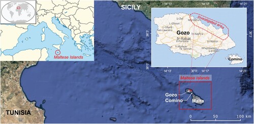
The Island of Gozo is the second largest among the Maltese Islands (Schembri, Citation2019) and holds remarkable environmental and cultural values (Coratza et al., Citation2016). It is located in the centre of the Mediterranean Sea, about 100 km south of Sicily and 300 km north-east of Tunisia (). Tourism-related economic revenue is an important component of the island’s economy, accounting for nearly half of the island’s GDP, and employing 20% of its workforce (Ministry for Tourism, Citation2015).
Figure 1. Geographic setting of Gozo within the Maltese Islands (central Mediterranean Sea). Satellite images are derived from Google Earth (map data: SIO, NOAA, US Navy, NGA, GEBCO, Landsat/Copernicus). The map data of Gozo and Comino islands (upper right corner) are derived from CitationOpenStreetMap database (2022). Geographic coordinates are represented in the WGS84 reference system.
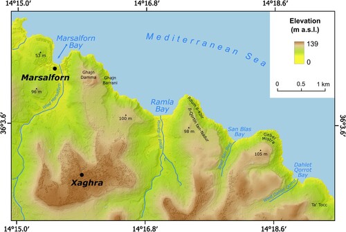
This study focuses on the north-eastern coastal stretch of Gozo, from Marsalforn Bay to Dahlet Qorrot Bay (). The investigated area hosts two renowned tourist destinations, Marsalforn Bay and Ramla Bay, both of great importance to Gozo tourism, and of significant geomorphological interest (Prampolini et al., Citation2018).
Figure 2. Physical setting of the study area (geographic coordinates are expressed in WGS84).
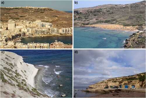
Marsalforn is one of the main inhabited coastal towns in Gozo ((a)). The availability of a significant number of accommodation facilities as well as restaurants, shops and diving centres contribute to a dense tourist population and remunerative businesses, which are remarkable especially during summer months. In Marsalforn, a wide range of utilities (electricity, roads, promenade, housing, etc.) are also located. Ramla Bay hosts the largest sandy beach of Gozo ((b)); it is characterized by golden-reddish sands, which makes this place peculiar and unique to the Maltese Islands. The bay also hosts a protected coastal dune system (the best preserved of the Maltese Islands) and cultural heritage features including the buried remains of a Roman villa, a Fougasse (a stone-firing cannon hollowed out in the rock), and a submerged seawall built in 1715 for defensive purposes. Moreover, two Special Areas of Conservation comprised in the Natura 2000 network extend along the investigated coastal stretch: Għajn Barrani, located east of Marsalforn ((c)), including Ramla Bay, and Il-Qortin tal-Magun and l-Qortin il-Kbir, located close to Dahlet Qorrot Bay. Moreover, in the latter bay, some traditional boat houses are located ((d)). All these features make the investigated coastal area particularly vulnerable to marine processes exacerbated by sea level rise. This may cause serious losses in economic terms as well as in the rich natural and cultural heritage of the investigated area.
Figure 3. Coastal landscapes of the north-eastern sector of the Island of Gozo: (a) the densely inhabited Marsalforn Bay; (b) the gold-reddish sands of Ramla Bay; (c) coastal clay slopes east of Marsalforn Bay within the Għajn Barrani protected area; (d) traditional boat houses at Dahlet Qorrot Bay.
Along the study area, a wide range of geomorphic features occur, including cliffs and plunging cliffs, coastal landslides of different types, sloping coasts, shore platforms, pocket beaches and submerged morphological features (Prampolini et al., Citation2018, Citation2021). The rocks outcropping in the study area comprise a Late Oligocene–Miocene marine sedimentary succession of five lithostratigraphic units in large part composed of limestones and clayey marls (Baldassini & Di Stefano, Citation2017; Pedley et al., Citation2002; Scerri, Citation2019). Oldest to youngest, the units comprise Lower Coralline Limestone Formatioņ Globigerina Limestone Formation, Blue Clay Formation, Greensand and Upper Coralline Limestone Formation. The Maltese Islands are crossed by two fault systems: one WSW-ENE oriented and the other NW-SE oriented (Galea, Citation2019). Low seismicity and GPS surveys show that the Maltese Islands are currently affected only by horizontal displacements due to the relative movement between the African and Eurasian continental plates (Serpelloni et al., Citation2007, Citation2013). Additionally, studies based on the analysis of archaeological markers and speleothems confirm the tectonic stability of the area (Furlani et al., Citation2013, Citation2018).
3. Materials and methods
In order to map the expected variations in coastline position induced by medium- and long-term sea level rise along the north-eastern sector of the Island of Gozo, the topographic setting of the study area was firstly analysed. In particular, the recognition of the expected future coastline positions was carried out by identifying the areas with a topographic elevation lower than the future sea levels, and therefore considered as prone to be potentially inundated by the rising sea (cf. Di Paola et al., Citation2021 and references therein). The analysis took advantage of the high-resolution topographic data available for the study area and derived from LiDAR data collected in 2013 by the Malta Environment and Planning Authority (CitationERDF, 2013, https://msdi.data.gov.mt/geoportal.html). In detail, the study used a Digital Terrain Model (DTM) with a cell resolution of 1 m. Coastline changes due to different sea levels were then evaluated by coupling high-resolution topographic data with sea level projections for the years 2050 and 2100 under two scenarios (expressed in terms of Shared Socio-economic Pathway – SSP scenarios). SSP1-2.6 represents a best-case scenario while scenario SSP5-8.5 is representative of the worst-case conditions with a fossil fuel development world and the absence of climate adaptation and mitigation policies throughout the twenty-first century (Meinshausen et al., Citation2020; O’Neill et al., Citation2014). Sea level projections were downloaded from the NASA Sea Level Projection Tool (https://sealevel.nasa.gov/data_tools/17) which provides the most updated global and local sea level projections from 2020 to 2150 relating to the baseline period of 1995–2014 (IPCC, Citation2021). In addition, in order to assess the combined effect of permanent and temporary sea level rise, the study used the Storm Surge indicator available from the CitationClimate Data Store (CDS) platform (https://cds.climate.copernicus.eu/cdsapp#!/dataset/sis-water-level-change-indicators?tab=overview). This indicator defines sea level increases due to storm surges with different return periods (2, 5, 10, 25, 50 and 100 years) expressed in metres above the current mean sea level. Along the coastal sectors, Copernicus data have a horizontal resolution of 0.1° (11.1 km) and are available for the medium- (2041–2070) and long- (2071–2100) term periods under the RCP8.5 and RCP4.5 climate scenarios, respectively. In this study, in order to consider events with high and low frequency, storm surges values with a return period of 10 and 100 years have been taken in consideration. Sea level and storm surge values taken into account for the analysis are indicated in and , respectively. Data elaboration and coastline mapping were carried out in a GIS environment by means of specific raster analysis tools. From the outputs of the GIS analysis, it was possible to extract the coastline positions for the present day and for all the considered future sea levels (cf. ); extracted coastlines were stored in a dedicated geodatabase and used to depict the Main Map.
Table 1. Sea level values used in this study for the evaluation of potential coastal inundation and coastline retreat under different scenarios.
Table 2. Storm surge values referred to return periods of 10 and 100 years which were used in this study for the evaluation of potential coastal inundation and coastline retreat under different scenarios.
In order to identify a local trend of the areal changes of the areas expected to be inundated, the surface of areas below future sea levels was calculated for the years 2030, 2040, 2050, 2060, 2070, 2080, 2090, 2100. Also in this case, sea level projections were referred to the AR6 (IPCC, Citation2021). The results of this analysis were expressed as percentage of the investigated area potentially inundated by considering:
the total surface of low-lying areas (i.e. areas with an elevation equal to or below 1 m);
the total surface of areas with an elevation below 5 m (i.e. areas considered to belong to the radius of influence of coastal erosion and flooding processes, as defined in the EUROSION Project http://www.eurosion.org/reports-online/part3.pdf).
Finally, in order to depict local coastal modifications which occurred as a response to the Holocene marine transgression, the sea level position relative to the LGM, corresponding to the −130 m bathymetric line, was detected from literature data (Foglini et al., Citation2016; Furlani et al., Citation2013; Micallef et al., Citation2013; Prampolini et al., Citation2017) and shown in an auxiliary map.
4. Results and discussion
The analyses carried out in this study have allowed the identification of coastal areas below future sea levels and therefore prone to be inundated at different time intervals. In detail, taking into consideration the SSP5-RCP8.5 scenario, the areas potentially affected by SLR inundation extend from 0.02 to 0.10 km2 in the period between 2030 and 2100 ().
Table 3. Extent of the areas potentially inundated by sea level rise under the scenarios SSP1-2.6 and SSP5-8.5.
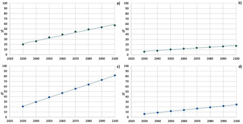
The topographic analysis has also allowed the calculation of the extent of low-lying areas (i.e. below and equal to 1 m) and of the areas below 5 m, which occupy respectively 0.13 and 0.42 km2. Taking into consideration the future sea-level projections for the year 2100, the analysis shows that, under the SSP1-RCP2.6 and SSP5-RCP8.5 scenarios, the area prone to be inundated will respectively occupy:
57% and 81.5% of the low-lying surface;
17% and 24.6% of the area below 5 m.
The percentage of areas affected by SLR is reported in in which the values calculated for each decade from 2020 to 2100 are indicated for both the scenarios SSP1-2.6 and SSP5-8.5.
Figure 4. Percentage of area potentially inundated resulting from the analysis of the extent of the low-lying areas (a, c) and of the area within 5 m above sea level (b, d). Upper panels (green dots) refer to SSP1-2.6 scenarios while lower panels (blue dots) refer to SSP5-8.5 scenarios.
The outputs of our analysis are shown in the Main Map which highlights areas with an elevation below the accounted future sea levels and provides the expected coastline positions under different scenarios in the medium- (2050) and long- (2100) term periods. Expected coastlines are reported as lines in orange for the 2050 scenarios and in red for the 2100 scenarios. Coastal zones potentially affected by storm surges with a return period of 100 years are also shown in the maps in light blue with the aim of depicting the worst-case condition which is relevant from a land management and planning perspective, to prioritize mitigation and adaptation actions. For merely graphical reasons, coastal areas that might be inundated in shorter return periods were not mapped. However, data relevant to a 10-year return period are reported in .
In the 3D view of the study area accompanying the Main Map, the −130 m bathymetric line is depicted (in red) with the aim of showing the high coastal modification occurring as a response to post-glacial marine transgression. It should be underlined that the eustatic signal along the Maltese coasts is not influenced by vertical land displacement due to tectonics; in fact, the Maltese Islands are currently considered as tectonically stable (Furlani et al., Citation2013, Citation2018; Serpelloni et al., Citation2007, Citation2013).
The definition of potential future shoreline positions has allowed this study to identify the bays of Ramla and Marsalforn as the most vulnerable areas within the investigated coastal stretch. In both cases, local modifications may affect the economic and tourist activities with significant risk implications (cf. Rizzo et al., Citation2022). In fact, the potential landward retreat of shoreline position as a consequence of temporary and permanent sea level rise on sandy beaches is particularly relevant given the significant socio-economic importance of such recreational areas. At Ramla Bay, shoreline retreat will significantly enhance the threat of erosion of the sand dune system located behind the beach – which represents the best-preserved dune system in the Maltese Islands – endangering its conservation and related ecological functions and services. Ramla Bay also hosts a plethora of archaeological features of cultural heritage and coastal clay slopes on the western arm of the beach, both highly sensitive to potential impacts of sea level rise (Rizzo et al., Citation2020, Citation2022).
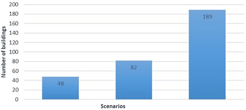
In the case of Marsalforn Bay, coastal inundation erosion is also compounded by the phenomenon of coastal squeeze due to the infrastructures (road) located in the immediate backshore (cf. Main Map). In addition, in this area, a wide range of utilities (electricity, roads, promenade, housing, etc.) will come under increased coastal inundation/retreat threat. The number of buildings affected by future sea levels has been calculated by analysing the most recent satellite images available for the investigated area, which refer to May 2021. The total number of buildings rises from 48 (in 2050) to 82 (in 2100) accounting for the sea level expected under the worst-case scenario (). The number increases up to 189 if the contribution of storm surge with a return period of 100 years is taken into consideration. The potentially affected buildings are mostly represented by residential structures and a number of tourist assets. The economic value of residences and catering establishments should not be overlooked. Apart from the ever-increasing restrictions on development within a small island context, such buildings represent extremely high-value sea-front positioning that has taken up the entire esplanade in this area. In addition, summer rental incomes are remarkable, not only in terms of value but also because of the extreme difficulty in locating availability.
Figure 5. Numbers of buildings potentially inundated considering the SSP5-8.5 scenario for the year 2050 (first column), 2100 (second column) and with the contribution of storm surge with a return period of 100 years (third column).
From a multi-risk perspective (Gallina et al., Citation2016, Citation2020), it is worth noting that the outflow of rainwater due to heavy storms emanating from the significantly sized catchment outflowing at Marsalforn Bay will be increasingly impinged, enhancing flooding issues regularly experienced at present time in this area.
Even if the assessment of the area potentially inundated by sea level rise is based on a static evaluation method, it can be considered suitable for the analysis carried out in coastal sectors where natural resilience and coastal morphological variations can be considered negligible, as in the case of the tectonically stable coasts in Gozo. By identifying the most vulnerable areas in the investigated sector, the results of this analysis allowed highlighting coastal zones where priority management actions should be oriented to reduce the economic impact that expected sea level rise may cause in the near future and to enhance the conservation of natural assets and their ecological functions. More detailed high-performing models should be implemented for modelling the expected damage on buildings (in the case of urban areas) and the potential natural adaptation (in the case of mobile coastal systems).
5. Conclusions
In its consideration that a fuller comprehension of coastal morphological evolution forms a critical contribution to the efficacy of coastal management, particularly in reaction to ongoing and predicted sea level rise, this paper assessed future scenarios of potential coastal inundation along the NE coast of the Mediterranean Island of Gozo, located centrally within an area considered as a ‘hotspot’ of climate change. This objective was addressed by identifying those coastal areas forecasted to be subject to permanent marine inundation at different time scales. The study area investigated was identified as hosting a rich socio, economic, ecologic and cultural heritage, with a tourism-related economic revenue accounting for approximately half of the island’s GDP; such assets were considered to aggravate vulnerability to marine processes exacerbated by sea level rise (cf. Batzakis et al., Citation2020).
In the assessment of the IPCC SSP5-8.5 scenarios, this study identified the areas likely to be affected by SLR inundation to range between 0.02 and 0.10 km2 in the period 2030–2100. Under scenarios SSP1-2.6 and SSP5-8.5, the future sea-level projections for the year 2100 were assessed to result in the inundation of 57% and 81.5% of the low-lying coastline and 17% and 24.6% of the areas below 5 m. In particular, the bays of Ramla and Marsalforn were identified as the most vulnerable within the investigated coastline. In the case of Ramla Bay, aggravated beach erosion was identified to pose a particular threat to the best-preserved sand dune system on the Maltese Islands, to a significant presence of archaeological remains and to coastal clay slopes on the western arm of the beach.
Given the highly built-up nature of Marsalforn embayment, the negative impacts of coastal inundation and enhanced erosion on a range of infrastructures, utilities, housing and beach/rock platform bathing facilities, were considered to become further aggravated by ‘coastal squeeze’. Incorporating storm surge enhancement of inundation, the study further identified that the number of buildings within Marsalforn that would be impacted by sea level rise would rise to 189.
The final output of the study was in the form of a map describing coastal areas below estimated future sea levels under different SLR scenarios for the medium- (2050) and long-term (2100) periods. Such a product was presented as an important contribution to awareness raising of local authorities and communities to potential threats from sea level rise and to improved coastal planning and management.
Software
The map and the layout were produced using ESRI ArcGIS (version 10.1), QGIS 3.24.2 and Inkscape vector graphics editor. The map was produced at a scale 1:5000 and embedded into the A1 size map frame. The Main Map is accompanied by the following inserts: a geographic and geological setting of the study area and a 3D view of Maltese Islands including the LGM shoreline position.
Supplemental Material
Download Zip (63.7 MB)Acknowledgements
The Authors are thankful to the four reviewers for their useful suggestions and grateful to the Malta Planning Authority (MPA) for providing LiDAR data and Dr. Marco Taviani and his team for providing bathymetric data of MEDCOR2009 oceanographic survey. This work is a contribution to IGCP Project 725 ‘Forecasting Coastal Change’.
Disclosure statement
No potential conflict of interest was reported by the author(s).
Data availability statement
The base map of the marine areas is a 5-m resolution Digital Terrain Model (DTM) resulting from the merge of bathymetric data acquired during different oceanographic surveys:
MEDCOR2009 carried out on board the R/V Urania of the CNR using the Kongsberg Simrad multibeam EM3002D and processed using CARIS HIPS & SIPS;
ERDF156 carried out by Malta Environment and Planning Authority (MEPA) on board the ISIS catamaran of the AquaBioTech Group using the SEA Company interferometric system SWATHplus-L.
Bathymetry from MEDCOR2009 is available for public consultation and downloadable at the resolution 1/16 * 1/16 arc minutes from the EMODnet Bathymetry Portal (https://portal.emodnet-bathymetry.eu/). The DTM of the Island of Gozo is 1 m-resolution and it is provided by the Malta Planning Authority. The data obtained in this study are available from the corresponding author [NS], upon reasonable request.
Additional information
Funding
References
- Amorosi, A., Pacifico, A., Rossi, V., & Ruberti, D. (2012). Late Quaternary incision and deposition in an active volcanic setting: The Volturno valley fill, southern Italy. Sedimentary Geology, 282, 307–320. https://doi.org/10.1016/j.sedgeo.2012.10.003
- Aucelli, P. P. C., Di Paola, G., Incontri, P., Rizzo, A., Vilardo, G., Benassai, G., Buonocore, B., & Pappone, G. (2017). Coastal inundation risk assessment due to subsidence and sea level rise in a Mediterranean alluvial plain (Volturno coastal plain – southern Italy). Estuarine, Coastal and Shelf Science, 198, 597–609. https://doi.org/10.1016/j.ecss.2016.06.017
- Baldassini, N., & Di Stefano, A. (2017). Stratigraphic features of the Maltese Archipelago: A synthesis. Natural Hazards, 86(S2), 203–231. https://doi.org/10.1007/s11069-016-2334-9
- Barra, D., Romano, P., Santo, A., Campaiola, L., Roca, V., & Tuniz, C. (1996). The Versilian transgression in the Volturno river plain (Campania, Southern Italy): Palaeoenvironmental history and chronological data. Il Quaternario, 9(2), 445–458.
- Batzakis, D., Misthos, L., Voulgaris, G., Tsanakas, K., Andreou, M., Tsodoulos, I., & Karymbalis, E. (2020). Assessment of building vulnerability to tsunami hazard in Kamari (Santorini Island, Greece). Journal of Marine Science and Engineering, 8(11), 886. https://doi.org/10.3390/jmse8110886
- Brown, S., Nicholls, R. J., Goodwin, P., Haigh, I. D., Lincke, D., Vafeidis, A. T., & Hinkel, J. (2018). Quantifying land and people exposed to sea-level rise with no mitigation and 1.5°C and 2.0°C rise in global temperatures to year 2300. Earth’s Future, 6(3), 583–600. https://doi.org/10.1002/2017EF000738
- Cazenave, A., Palanisamy, H., & Ablain, M. (2018). Contemporary sea level changes from satellite altimetry: What have we learned? What are the new challenges? Advances in Space Research, 62(7), 1639–1653. https://doi.org/10.1016/j.asr.2018.07.017
- Church, J. A., & White, N. J. (2011). Sea-level rise from the late 19th to the early 21st century. Surveys in Geophysics, 32(4-5), 585–602. https://doi.org/10.1007/s10712-011-9119-1
- Climate Data Store. (2020). Retrieved July 15, 2022, from https://cds.climate.copernicus.eu/cdsapp#!/dataset/sis-water-level-change-indicators?tab=overview.
- Coratza, P., Gauci, R., Schembri, J. A., Soldati, M., & Tonelli, C. (2016). Bridging natural and cultural values of sites with outstanding scenery: Evidence from Gozo, Maltese Islands. Geoheritage, 8(1), 91–103. https://doi.org/10.1007/s12371-015-0167-7
- Da Lio, C., & Tosi, L. (2018). Land subsidence in the Friuli Venezia Giulia coastal plain, Italy: 1992–2010 results from SAR-based interferometry. Science of the Total Environment, 633, 752–764. https://doi.org/10.1016/j.scitotenv.2018.03.244
- Dangendorf, S., Marcos, M., Wöppelmann, G., Conrad, C. P., Frederikse, T., & Riva, R. (2017). Reassessment of 20th century global mean sea level rise. Proceedings of the National Academy of Sciences, 114(23), 5946–5951. https://doi.org/10.1073/pnas.1616007114
- Di Paola, G., Rizzo, A., Benassai, G., Corrado, G., Matano, F., & Aucelli, P. P. C. (2021). Sea-level rise impact and future scenarios of inundation risk along the coastal plains in Campania (Italy). Environmental Earth Sciences, 80(17), 1–22. https://doi.org/10.1007/s12665-021-09884-0
- ERDF 156 data. (2013). Developing national environmental monitoring infrastructure and capacity. Malta Environment and Planning Authority.
- Foglini, F., Prampolini, M., Micallef, A., Angeletti, L., Vandelli, V., Deidun, A., & Taviani, M. (2016). Late Quaternary coastal landscape morphology and evolution of the Maltese Islands (Mediterranean Sea) reconstructed from high-resolution seafloor data. In J. Harff, G. Bailey, & L. Lüth (Eds.), Geology and archaeology: Submerged landscapes of the continental shelf (pp. 77–95). Geological Society, Special Publication.
- Furlani, S., Antonioli, F., Biolchi, S., Gambin, T., Gauci, R., Lo Presti, V., Anzidei, M., Devoto, S., Palombo, M., & Sulli, A. (2013). Holocene sea level change in Malta. Quaternary International, 288, 146–157. https://doi.org/10.1016/j.quaint.2012.02.038
- Furlani, S., Antonioli, F., Gambin, T., Biolchi, S., Formosa, S., Lo Presti, V., Mantovani, M., Anzidei, M., Calcagnile, L., & Quarta, G. (2018). Submerged speleothem in Malta indicates tectonic stability throughout the Holocene. The Holocene, 28(10), 1588–1597. https://doi.org/10.1177/0959683618782613
- Galea, P. (2019). Central Mediterranean tectonics – A key player in the geomorphology of the Maltese Islands. In R. Gauci & J. A. Schembri (Eds.), Landscapes and landforms of the Maltese Islands. World geomorphological landscapes (pp. 19–30). Springer.
- Gallina, V., Torresan, S., Critto, A., Sperotto, A., Glade, T., & Marcomini, A. (2016). A review of multi-risk methodologies for natural hazards: Consequences and challenges for a climate change impact assessment. Journal of Environmental Management, 168, 123–132. https://doi.org/10.1016/j.jenvman.2015.11.011
- Gallina, V., Torresan, S., Zabeo, A., Critto, A., Glade, T., & Marcomini, A. (2020). A multi-risk methodology for the assessment of climate change impacts in coastal zones. Sustainability, 12(9), 3697. https://doi.org/10.3390/su12093697
- Giorgi, F. (2006). Climate change hot-spots. Geophysical Research Letters, 33(8), L08707. https://doi.org/10.1029/2006GL025734
- Giorgi, F., & Lionello, P. (2008). Climate change projections for the Mediterranean region. Global and Planetary Change, 63(2-3), 90–104. https://doi.org/10.1016/j.gloplacha.2007.09.005
- Hay, C. C., Morrow, E., Kopp, R. E., & Mitrovica, J. X. (2015). Probabilistic reanalysis of twentieth-century sea-level rise. Nature, 517(7535), 481–484. https://doi.org/10.1038/nature14093
- Horton, B. P., Kopp, R. E., Garner, A. J., Hay, C. C., Khan, N. S., Roy, K., & Shaw, T. A. (2018). Mapping sea-level change in time, space, and probability. Annual Review of Environment and Resources, 43(1), 481–521. https://doi.org/10.1146/annurev-environ-102017-025826
- Intergovernmental Panel on Climate Change. (2021). Climate change 2021: The physical science basis. In V. Masson-Delmotte, P. Zhai, A. Pirani, S. L. Connors, C. Péan, S. Berger, N. Caud, Y. Chen, L. Goldfarb, M. I. Gomis, M. Huang, K. Leitzell, E. Lonnoy, J. B. R. Matthews, T. K. Maycock, T. Waterfield, O. Yelekçi, R. Yu, & B. Zhou (Eds.), Contribution of working group I to the sixth assessment report of the Intergovernmental Panel on Climate Change (pp. 3–2391). Cambridge University Press.
- IPCC. (2021). IPCC AR6 sea level projection tool. Retrieved October 10, 2021, from https://sealevel.nasa.gov/data_tools/17
- Jevrejeva, S., Moore, J. C., Grinsted, A., Matthews, A. P., & Spada, G. (2014). Trends and acceleration in global and regional sea levels since 1807. Global and Planetary Change, 113, 11–22. https://doi.org/10.1016/j.gloplacha.2013.12.004
- Karymbalis, E., Tsanakas, K., Karkani, A., & Evelpidou, N. (2022). Tectonics and sea-level fluctuations. Journal of Marine Science and Engineering, 10(3), 334. https://doi.org/10.3390/jmse10030334
- Lambeck, K., Antonioli, F., Anzidei, M., Ferranti, L., Leoni, G., Scicchitano, G., & Silenzi, S. (2011). Sea level change along the Italian coast during the Holocene and projections for the future. Quaternary International, 232(1-2), 250–257. https://doi.org/10.1016/j.quaint.2010.04.026
- Legeais, J. F., Ablain, M., Zawadzki, L., Zuo, H., Johannessen, J. A., Scharffenberg, M. G., Fenoglio-Marc, L., Joana Fernandes, M., Andersen, O. B., Rudenko, S., Cipollini, P., Quartly, G. D., Passaro, M., Cazenave, A., & Benveniste, J. (2018). An improved and homogeneous altimeter sea level record from the ESA climate change initiative. Earth System Science Data, 10(1), 281–301. https://doi.org/10.5194/essd-10-281-2018
- Marriner, N., Gambin, T., Djamali, M., Morhange, C., & Spiteri, M. (2012). Geoarchaeology of the Burmarrad ria and early Holocene human impacts in western Malta. Palaeogeography, Palaeoclimatology, Palaeoecology, 339-341, 52–65. https://doi.org/10.1016/j.palaeo.2012.04.022
- Matano, F., Sacchi, M., Vigliotti, M., & Ruberti, D. (2018). Subsidence trends of Volturno river coastal plain (northern Campania, southern Italy) inferred by SAR interferometry data. Geosciences, 8(1), 8. https://doi.org/10.3390/geosciences8010008
- MedECC. (2020). Climate and environmental change in the Mediterranean basin – Current situation and risks for the future. First Mediterranean assessment report. In W. Cramer, J. Guiot, & K. Marini (Eds.), Mediterranean assessment report (pp. 14–628). Union for the Mediterranean, Plan Bleu, UNEP/MAP.
- Meinshausen, M., Nicholls, Z. R., Lewis, J., Gidden, M. J., Vogel, E., Freund, M., Beyerle, U., Gessner, C., Nauels, A., Bauer, N., Canadell, J. G., Daniel, J. S., John, A., Krummel, P. B., Luderer, G., Meinshausen, N., Montzka, S. A., Rayner, P. J., Reimann, S., … Wang, R. H. (2020). The shared socio-economic pathway (SSP) greenhouse gas concentrations and their extensions to 2500. Geoscientific Model Development, 13(8), 3571–3605. https://doi.org/10.5194/gmd-13-3571-2020
- Micallef, A., Foglini, F., Le Bas, T., Angeletti, L., Maselli, V., Pasuto, A., & Taviani, M. (2013). The submerged paleolandscape of the Maltese Islands: Morphology, evolution and relation to Quaternary environmental change. Marine Geology, 335, 129–147. https://doi.org/10.1016/j.margeo.2012.10.017
- Ministry for Tourism. (2015). The contribution of the tourism industry to the Maltese economy. Report prepared for the Ministry for Tourism by EU-Cubed Consultants. Retrieved March 4, 2022, from https://tourism.gov.mt/en/Documents/The%20Contribution%20Of%20The%20Tourism%20Industry%20To%20The%20Maltese%20Economy%20-%202014.pdf
- Nerem, R. S., Beckley, B. D., Fasullo, J. T., Hamlington, B. D., Masters, D., & Mitchum, G. T. (2018). Climate-change-driven accelerated sea-level rise detected in the altimeter era. Proceedings of the National Academy of Sciences, 115(9), 2022–2025. https://doi.org/10.1073/pnas.1717312115
- O’Neill, B. C., Kriegler, E., Riahi, K., Ebi, K. L., Hallegatte, S., Carter, T. R., Mathur, R., & van Vuuren, D. P. (2014). A new scenario framework for climate change research: The concept of shared socioeconomic pathways. Climatic Change, 122(3), 387–400. https://doi.org/10.1007/s10584-013-0905-2
- OpenStreetMap database. (2022). https://www.openstreetmap.or.
- Palmer, M. D., Domingues, C. M., Slangen, A. B. A., & Dias, F. B. (2021). An ensemble approach to quantify global mean sea-level rise over the 20th century from tide gauge reconstructions. Environmental Research Letters, 16(4), 044043. https://doi.org/10.1088/1748-9326/abdaec
- Papanastassiou, D., Cundy, A., Gaki-Papanastassiou, K., Frogley, M., Tsanakas, K., & Maroukian, H. (2014). The uplifted terraces of the Arkitsa region, NW Evoikos Gulf, Greece: A result of combined tectonic and volcanic processes? The Journal of Geology, 122(122), 397–410. https://doi.org/10.1086/676595
- Pedley, H. M., Hughes Clarke, M., & Galea, P. (2002). Limestone isles in a crystal sea: The geology of the Maltese Islands. Publishers Enterprises Group. 109 pp.
- Prampolini, M., Coratza, P., Rossi, S., Parenti, C., Galea, C., Caruana, A., & Soldati, M. (2021). Geomorphology of the seafloor north east of the Maltese Islands, central Mediterranean. Journal of Maps, 17(2), 465–475. https://doi.org/10.1080/17445647.2021.1957034
- Prampolini, M., Foglini, F., Biolchi, S., Devoto, S., Angelini, S., & Soldati, M. (2017). Geomorphological mapping of terrestrial and marine areas, northern Malta and Comino (central Mediterranean Sea). Journal of Maps, 13(2), 457–469. https://doi.org/10.1080/17445647.2017.1327507
- Prampolini, M., Gauci, C., Micallef, A. S., Selmi, L., Vandelli, V., & Soldati, M. (2018). Geomorphology of the north–eastern coast of Gozo (Malta, Mediterranean Sea). Journal of Maps, 14(2), 402–410. https://doi.org/10.1080/17445647.2018.1480977
- Prampolini, M., Savini, A., Foglini, F., & Soldati, M. (2020). Seven good reasons for integrating terrestrial and marine spatial datasets in changing environments. Water, 12(8), 2221. https://doi.org/10.3390/w12082221
- Rizzo, A., Vandelli, V., Buhagiar, G., Micallef, A. S., & Soldati, M. (2020). Coastal vulnerability assessment along the north-eastern sector of Gozo Island (Malta, Mediterranean Sea). Water, 12(5), 1405. https://doi.org/10.3390/w12051405
- Rizzo, A., Vandelli, V., Gauci, C., Buhagiar, G., Micallef, A. S., & Soldati, M. (2022). Potential sea level rise inundation in the Mediterranean: From susceptibility assessment to risk scenarios for policy action. Water, 14(3), 416. https://doi.org/10.3390/w14030416
- Romano, P., Santo, A., & Voltaggio, M. (1994). L'evoluzione geomorfologica della Pianura del Fiume Volturno (Campania) durante il tardo Quaternario (Pleistocene medio superiore-Olocene). Il Quaternario, 7(1), 41–56.
- Sacchi, M., Molisso, F., Pacifico, A., Vigliotti, M., Sabbarese, C., & Ruberti, D. (2014). Late-Holocene to recent evolution of Lake Patria, South Italy: An example of a coastal lagoon within a Mediterranean delta system. Global and Planetary Change, 117, 9–27. https://doi.org/10.1016/j.gloplacha.2014.03.004
- Santangelo, N., Ciampo, G., Di Donato, V., Esposito, P., Petrosino, P., Romano, P., Russo Ermolli, E., Santo, A., Toscano, F., & Villa, I. (2010). Late Quaternary buried lagoons in the northern Campania plain (southern Italy): evolution of a coastal system under the influence of volcano-tectonics and eustatism. Italian Journal of Geosciences, 129(1), 156–175. https://doi.org/10.3301/IJG.2009.1.
- Scerri, S. (2019). Sedimentary evolution and resultant geological landscapes. In R. Gauci & J. A. Schembri (Eds.), Landscapes and landforms of the Maltese Islands. World geomorphological landscapes (pp. 31–47). Springer.
- Schembri, J. A. (2019). The geographical context of the Maltese Islands. In R. Gauci & J. A. Schembri (Eds.), Landscapes and landforms of the Maltese Islands. World geomorphological landscapes (pp. 9–17). Springer.
- Serpelloni, E., Faccenna, C., Spada, G., Dong, D., & Williams, S. D. (2013). Vertical GPS ground motion rates in the Euro-Mediterranean region: New evidence of velocity gradients at different spatial scales along the Nubia-Eurasia plate boundary. Journal of Geophysical Research: Solid Earth, 118(11), 6003–6024. https://doi.org/10.1002/2013JB010102
- Serpelloni, E., Vannucci, G., Pondrelli, S., Argnani, A., Casula, G., Anzidei, M., Baldi, P., & Gasperini, P. (2007). Kinematics of the Western Africa-Eurasia plate boundary from focal mechanisms and GPS data. Geophysical Journal International, 169(3), 1180–1120. https://doi.org/10.1111/j.1365-246X.2007.03367.x