
SUPPORTING CITY KNOW-HOW
Evidence supports what we all know; that human health and planetary health are heavily influenced by the urban environments we create. However, outcomes for human and planetary health both show worrying trends of ongoing and increasing risks. These should be of global concern. It is imperative that we use policy, programmes and projects for testing solutions as core focus for urban interventions. This requires concerted action. Cities & Health is dedicated to supporting a multidirectional flow of knowledge to support such action. Our aim is to foster connections and conversations between researchers, practitioners, policy-makers, communities, and decision-makers in cities. That is the specific purpose of this innovative section of the journal, with its short ‘City Know-how’ policy briefings from research findings. The team at Cities & Health, and our two knowledge partners (International Society for Urban Health and SALUS.Global), invite you to join their networks, and contribute to the conversations we so urgently need. We call out internationally to communities, researchers, practitioners and policy-makers to consider publishing in Cities & Health to help influence urban policy.
The leading editorial in this issue addresses the importance of defining the social return on investments. Evaluation tools that provide an assessment of the social return on investment have an important role to play in our work. Especially when considering that many of the key interventions for healthier place-making are best justified through focusing on the resultant co-benefits.
To complement this editorial, and as an example of the approach, we have included an empirical paper about the social return on investment of an urban regeneration project. That article is one of 14 research papers in this issue; comprising five empirical studies, five methodological papers and four evidence reviews.
On another subject completely - this issue is unusual, even for Cities & Health, in containing five book reviews! Book reviews serve many purposes. In a fast moving field, such as healthy city planning and design, reviews can help us all keep on top of new publications. They can be a great way for early career practitioners or researchers to get published, plus we hope they provide support for those wanting to extend their own understanding of the depth and breadth of urban health through spatial planning, and place-making.
In today’s publishing environment, with open access fees, it is becoming harder for journals to justify publishing book reviews. Many journals no longer do so. We want to buck that trend for as long as we can. To assist access, we will shortly set up a collection of all our book reviews on the journal website, so they can be found together, in one place.
An economic evaluation of an urban green and blue space intervention in Northern Ireland
The Hollow and Dixon Playing Fields – newly constructed multipurpose foot and cycle path added to a segment of the Connswater Community Greenway with the addition of 24-hour illuminated lighting columns. Source: EastSide Greenways.
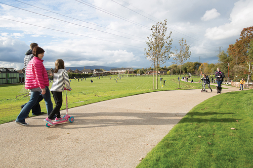
Our study shows that urban green and blue space interventions make an important contribution to the economy in Belfast, Northern Ireland. We discuss the multifunctional benefits of green spaces and how these translate into a positive return on investment.
For the attention of: Policymakers interested in environmental health and sustainable urbanisation; academics and researchers; urban planners and designers.
The problem: The Connswater Community Greenway was a major urban regeneration project in Belfast, Northern Ireland that involved the provision of urban greenway, a new civic square, improved foot and cycle paths, as well as flood alleviation measures. However, there are few studies that have attempted to measure the economic value of urban green and blue space interventions. Therefore, little is known about how the social, economic, and environmental benefits of these spaces translate into monetary gains for the economy.
What we did and why: We conducted an economic evaluation of the Connswater Community Greenway. The aim was to examine the contribution of the Greenway to: property values; flood alleviation; tourism; biodiversity; climate change; health and wellbeing; crime; and employment/productivity. By comparing these benefits against the total costs of the project, we demonstrate how the Greenway is a good investment for the local economy.
What our study adds: We explore the societal impact of the CCG and discuss the scope for further research in the area of economic evaluations of UGBS.
Overall, the results showed that the Greenway will provide a positive return on investment over its 40-year projected lifetime. The present study supports the use of economic evaluations in identifying the value of urban green and blue spaces, and the contribution they make to the economy.
Implications for city policy and practice: Policymakers and urban planners should consider urban green and blue spaces as a resource that promotes economic benefits for the economy as well as social and environmental benefits.
For further information: Groundswell Consortium information: regarding the research team
Connswater Community Greenway information: about the Connswater Community Greenway and the various community engagement initiatives that are ongoing
Full research article: The social return on investment of an urban regeneration project using real-world data: the Connswater Community Greenway, Belfast, UK by Christopher Tate, Ciaran O’Neill, Ngan Tran, Leonie Heron, Frank Kee, Mark A. Tully, Mary Dallat & Ruth F. Hunter.
Are schools and colleges in the heart of Delhi complying with India’s anti-smoking regulation?
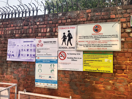
The signboard outside of a school in New Delhi’s administrative precinct prohibiting sale of cigarettes and tobacco products within 100 yards. Source: Author.
A look into the heart of Delhi’s Schools and colleges to see whether they are complying to India’s Anti Smoking regulation. Are the signboards in place? Are there vendors within 100 yards? Are young people safe from cigarette promotion?
For the attention of: The World Health Organization, The Indian Government, The Minister of Health and Family Welfare, Principals of Schools and Colleges in major cities
The problem: India enacted the Anti-smoking law COTPA in 2003. There are educational institutes which may not put the required board for anti-smoking law compliance. There also may be cigarette vendors present within 100 yards of educational institutions. This may be all the more crucial as there is defiance in the heart of India’s capital city, the administrative centre of India.
What we did and why: We surveyed the surroundings of schools to see whether the required signboards had been placed outside of schools or not. We also checked to see whether there were vendors present within the prohibited 100 yards of these educational institutions.
What our study adds: We clearly shed light on the present status of non-compliance of the signboard regulation in the administrative precinct of New Delhi, India. In addition:
● We provide details of non-compliance where the exact requirement of the signboards may not be met, and the educational institution may do something else in its place.
● We show the defiant presence of cigarette and tobacco vendors within the proximity of educational institutions.
Implications for city policy and practice: This is a very crucial study as it will require enhanced implementation of the Cigarettes and Other Tobacco Products (Prohibition of Advertisement and Regulation of Trade and Commerce, Production, Supply and Distribution) Act, 2003.
We suggest the need to increase the teeth of anti-tobacco law in India. This may work for other cities having statues related to traffic restrictions or fast food sales, where compliance checks may be needed – as mere statute-making may not always be enough.
The study brings to light the need for understanding that mere formulation of statute needs the complementary step of assessment for compliance; and of securing bottom-up involvement and implementation through community action.
For further information: Ministry of Health & Family Welfare, Government of India: India’s Tobacco Laws:
Full research article: Signboards prohibiting tobacco sale within 100 yards of educational institutes: the appraisal of prohibition compliance and on-ground status of the anti-smoking law in New Delhi’s major administrative precinct by Raja Singh.
Do bike lanes and bike-sharing systems provide access to active mobility for all?
Bike Lane at Av. Duque d’Ávila, Lisbon. Image: the author.
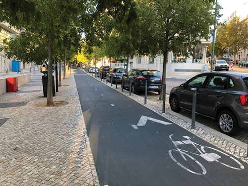
In Lisbon disadvantaged areas have worse access to bike lanes and bike-sharing systems
For the attention of: Urban cycling organisations, WHO European Healthy Cities Network, Urban designers
The problem: Bicycle lanes and bike-sharing systems are increasingly popular responses to mitigate the challenges of public health and environmental sustainability. However, implementation can raise issues linked to equity. Inequity of access to the cycling network reinforces social disparities in health and access to resources and opportunities. We thus need to know how equitable the spatial distribution of cycling infrastructure is, and if more vulnerable communities have poorer access.
What we did and why: This study examines whether an area-level material deprivation index is associated with different levels of accessibility to (i) cycling network and (ii) bike-sharing docking stations network. Independent t-tests were implemented, and regression models were performed to estimate the associations of the multiple deprivation index with each dependent bike lane and bike-sharing docking station variable, adjusting for covariates.
What our study adds: Our results indicate that:
● a significant difference exists between the most and least deprived areas in terms of access to cycling infrastructures,
● higher material deprivation is associated with a lower presence of, greater distance to, and lower coverage of bike-sharing docking stations and coverage of cycle lane networks,
● underlying characteristics of urban areas (increased slope, people aged 18-35) play a major role.
Implications for city policy and practice: Our study and its approach offer useful additional evidence and techniques that can provide public authorities recommendations about how to conduct future cycling network extension projects. Based on the study’s findings, efforts should be directed to increase access to bike lanes and bike-sharing systems in more deprived areas.
For further information:
Full research article: Cycling infrastructures and equity: an examination of bike lanes and bike sharing system in Lisbon, Portugal by Miguel Padeiro.
Connecting sense of place, nature relatedness, and views of, and walkability to, nature
French Creek by the MABR Photo credit: Mount Arrowsmith Biosphere Region.
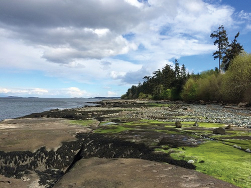
Connecting sense of place, nature relatedness, and views of, and walkability to, nature. Lessons in environmental psychology; sense of place and nature relatedness. Study from the Mount Arrowsmith Biosphere Region, British-Columbia, Canada.
For the attention of: Urban planners, municipal policy makers and community planning scholars
The problem: This study was part of a broader project examining human impacts within the Mount Arrowsmith Biosphere Region (MABR)—a UNESCO-designated biosphere reserve on Vancouver Island in British Columbia, Canada. Our aim was to understand the extent to which individuals in six electoral Mount Arrowsmith Biosphere Region communities experience psychological variables that are often linked to pro-social and pro-environmental outcomes, such as sense of place and nature-relatedness.
What we did and why: We used a mixed-methods online survey design to measure how these attitudes relate to residents’ perceived views of, and walkable access to, nature.
In this paper, we also summarize and synthesize a large body of literature on sense of place and nature relatedness before embarking on an empirical study on how these psychological constructs associate for community members of six communities in the Mount Arrowsmith Biosphere Region on Vancouver Island, British Columbia.
What our study adds: We found that residents’ sense of place was neutral overall, while their nature relatedness and perceptions of views and access to nature were significantly stronger. Residents’ place attachment was significantly higher than their place identity and place dependence. Although sense of place and nature relatedness, and sense of place and perceptions of views and walkable access to nature, correlated overall, significant associations were not revealed in each of the six communities. In addition, over 60% of responses to an open-ended item asking about specific physical attributes in the community that contribute to sense of place had to do with the natural environment—instead of social or recreational amenities
Overall, this work adds to an existing discussion of what the Mount Arrowsmith Biosphere Region means to those who use it and call it home, and to what the body of environmental psychology literature can communicate to interdisciplinary scholars concerning sense of place, natural relatedness, and how community members perceive these attitudes in relation to views of, and walkable access to, nature.
Implications for city policy and practice: Our findings suggest that sense of place, nature relatedness, and perceptions of views and walkable access to nature are interrelated psychological constructs. However, a more focused investigation of the specific antecedents and outcomes of sense of place in these six communities is recommended, particularly using focus groups, interviews, and other qualitative methods to understand more about the strength of sense of place felt toward the MABR. Such an endeavour may help to further generalize our results to comparable towns and communities around the world.
Municipal planners may wish to capitalize on the restorative effects that arise when community members form a connection with nature, and concentrate funding or public engagement efforts on trails, parks, and other natural features to bolster sense of place in coastal and mountainous communities.
For further information: Mount Arrowsmith Biosphere Region Research Institute
Full research article: Associating sense of place and nature relatedness in the British Columbia Mount Arrowsmith Biosphere Region: a case study by Lindsay J. McCunn, Karissa Sawyer & Taylor Shorting.
Liveability research links public health and urban planning in the Australian Urban Observatory

Liveability indicators link health and place in the Australian Urban Observatory and are critical to the development to the health and wellbeing of the population and a wellbeing economy. Evidence informed decision-making requires access to research designed for decision-makers.
For the attention of: City planners, policymakers, decision makers, students, advocacy agencies, non-government organisations, health professionals.
The problem: Current methods of city planning that aggregate and average results for large geographic areas like municipalities all to often mask health inequities and socio-spatial disadvantage. W need new forms of easy-to-understand research evidence to support evidence-informed policy and planning for city design. Evidence should be used to identify place-based liveability strengths and weaknesses linked to city design. This can also help prioritise actions that promote health, equity and sustainability in neighbourhoods across all areas of a city.
What we did and why: We developed the Australian Urban Observatory to make it easy for policymakers and planners across the 21 largest cities of Australia to incorporate research evidence on liveability into city planning. We made it easy to visualise what city liveability looks like down at the neighbourhood, suburb and municipal level. This is needed to identify liveability strengths and weaknesses, and to identify and prioritise liveability issues of policy or planning priority. It also helps monitor changes in city-based liveability over time. Most importantly we have campaigned to shift conversations and educate decision-makers about the impact of urban policy and planning decisions on health.
What our study adds: We developed a custom-made digital liveability planning platform giving us the ability to visualise the local liveability of over 40,000 neighbourhoods across 21 Australian cities and monitor changes in liveability over time. This research describes how the Australian Urban Observatory was developed to bridge the gap between academic research, policy and practice. It provides examples of how liveability research, tools and capacity building actions are supporting the translation of research knowledge into decision-making practice to support better designed and healthier Australian cities.
Implications for city policy and practice: Understanding local lived environments through the study of liveability provides an excellent model of linking integrated spatial planning that supports and encourages healthy and sustainable places. Liveability and health inequities are directly related to the decisions made in city planning departments. We demonstrate how new methods of data visualisation and research translation accessible through an Australian urban observatory are needed to understand, prevent and act on these unfair and avoidable differences within urban areas across the globe.
For further information: Australian Urban Observatory
Full research article: Liveability research creating real world impact: connecting urban planning and public health through the Australian Urban Observatory by Melanie Davern, Alan Both, Katherine Murray, Rebecca Roberts & Fadhillah Norzahari
“You can’t change what you can’t measure”: auditing the micro-environment of Limassol neighbourhoods, Cyprus
Street art depicting a cafe-like in what could be a town square, people of all ages and backgrounds have come together in a common task. This street art featured on a wall on Pythonos Street in the historic centre of Nicosia, but no longer exists. Credit: Photograph of street art, entitled ‘People of Cyprus’, by street artist Paparazzi.

Our Neighbourhood Observational Tool for auditing urban community environments, called CyNOTes, depicts unequal profiles of the neighbourhood micro-scale environment, highlighting the environmental inequity in residents’ experience and quality of life.
For the attention of: Epidemiology and Public Health Associations, Neighbourhood and Health interests
The problem: Various methods are used to profile communities, all with advantages and shortcomings. Neighbourhood audits can provide valuable information about actual contextual features of the micro-scale environment of neighbourhoods relevant to residents’ health, not captured by other methods. Given the cultural-specificity of audit tools, there is need to develop or adapt audit tools to different urban settings.
What we did and why: We assessed the feasibility of neighbourhood audits in the city of Limassol, by developing and piloting testing CyNOTes, a 126-item audit tool tapping on microscale features of the physical, built and social environment. The prevalence, variability and differences of audited features were assessed by two independent raters in repeat audits across thirty street blocks in three distinct groups of neighbourhoods, stratified by educational attainment of residents.
What our study adds:
With good inter- and intra-rater agreement, criterion and predictive validity, CyNOTes is the first audit tool in the community assessment toolbox culturally adapted to the specifics of the Cypriot city.
CyNOTes captured the variability in the neighbourhood environment, providing evidence of social inequity with more adverse neighbourhood conditions along the socioecomomic disadvantage continuum and quantifiable evidence of the unequal experience of citizens.
Implications for city policy and practice:
Depicting environmental inequity can trigger and widen the conversation among the local research community and policy-makers with regards to the wider social determinants of health and the role of the neighborhood environment in promoting health and health-related behaviours.
Further development will allow scaling-up the use of CyNOTes in the context of community assessment and citizens’ advocacy, allowing planning and implementation of relevant neighbourhood regeneration programmes based on actual observable needs of the community.
Full research article: Developing and field testing the Neighbourhood Observational Tool for auditing urban community environments (CyNOTes) in the city of Limassol, Cyprus by Daphne Kleopa, Andrie Panayiotou, Christiana Kouta & Nicos Middleton.
Shade equity: Determining tree planting locations with suitability analysis
Neighbourhood with Jacaranda Trees. Source: Pexels_Magda Ehlers.

Rising temperatures and minimal shade coverage offer little escape from the sweltering heat some citizens endure in cities throughout the world.
For the attention of: Municipal managers, local communities, non-profits, landscape architects and city governments
The problem: In South African cities, increasing temperatures and minimal shade coverage offer little escape from the sweltering heat some citizens endure in their commutes. Researchers are finding that there is a disproportionate amount of shade coverage in certain areas, drawing concerns that the distribution of shade is not equitable.
What we did and why: In this study, we measure tree equity analysis in two South African cities. The study then uses GIS-based Multi-criteria Decision Analysis for identifying and prioritizing tree planting sites in order to promote equitable access to tree canopy coverage across a city.
What our study adds: Tracking larger social and environmental changes due to conservation and reforestation efforts is an important element of using GIS. Planted trees in the prioritised areas can be recorded on the GIS system, and the city can audit and monitor success rates.
● Uses GIS-based Multi-criteria Decision Analysis (MCDA) to prioritise new tree planting locations at the census sub-place level.
● Equity, vulnerability, and the environment are the three sub-place objectives on which the criteria are based.
● In this regard, tree planting places will be prioritised considering the advantages of tree planting based on where the benefits of trees are most needed and have the most community benefit in relation to the study sub-pace objectives.
Implications for city policy and practice: Financial sustainability and resilience can be achieved by planting native, drought resistant, and exotic trees adapted to the local environment.
● Tracking larger social and environmental changes due to conservation and reforestation efforts is an important element of using GIS. Planted trees in the prioritised areas can be recorded on the GIS system, and the city can audit and monitor success rates.
● Financial sustainability and resilience can be achieved by planting native, drought-resistant, and exotic trees adapted to the local environment.
Full research article: Using spatial analytics to model tree planting priorities in two South African cities of Bloemfontein and Kimberley by Tabaro H. Kabanda & Amanda N. Gumede.
The use of fuzzy modelling in making decisions that improve the desirability of neighbourhoods for their residents
In researching perceived environment and neighbourhood satisfaction, the main challenge in datasets can be data uncertainty. We use fuzzy logic to deal with this. One of the main advantages of fuzzy logic is non-sensitivity to uncertain and noisy data. The focus of this study was the problem of handling uncertainty when rating scores, this was accomplished by ‘fuzzifying’ the rating values.
For the attention of: Those advising Mayors of urban districts and Mayor’s executive assistants; urban researchers
The problem: In researching perceived environment and neighbourhood satisfaction we faced a great deal of uncertainty and impreciseness in the values provided by our respondents. In other words, our data were not precise enough to be relied on for mathematical prediction models.
On the other hand, subjective ordered variables, e.g. satisfaction, could not be interpreted meaningfully through normal means (multivariate logit models) or even other approaches used in such cases. Hence, we faced blocks and limitations to use of the usual statistical analysis (regression models).
What we did and why: We developed a set of fuzzy estimation systems, each of which predicted the value of neighborhood satisfaction using the values of just one specific subset of the influencing independent variables. The main advantage of fuzzy logic is its non-sensitivity to uncertainty and ‘noise’ in the data. In the proposed model, we did not preserve the original data features. However, we set up fuzzy rules, whereby all necessary antecedents and features, fuzzy sets, and their frequency in the rules were clear.
What our study adds: Any analysis of our model (e.g. sensitive analysis or extracting adversarial examples) will be easy. Experts can insert, remove or edit any rule in our model to adapt, what is in essence, a pretrained system. One of the main advantages of the model we have introduced is its non-sensitivity to uncertainty and noise in the data.
Implications for city policy and practice: We present important implications for policy-makers in our findings and our method. Perceived security, as the most important requirement for achieving a satisfactory neighborhood, must be given special focus through community design policies and guidelines. We also found that when working on subjective data in decision making, it is necessary to use fuzzy modeling approach to handle the uncertainty and impreciseness in the gathered data.
Full research article: Perceived environment and neighbourhood satisfaction: introducing a fuzzy modeling approach by Seyed Mojtaba Fakhrahmad, Seyed Mostafa Fakhrahmad, Ali Soltani & Khalil Hajipour.
How to use Google Street View to study changes in neighbourhood disorder?
Google Street View image of a crossroads in Philadelphia in 2017 (A) and 2007 (B) © 2023 Google. Terms and conditions for use of images applies.
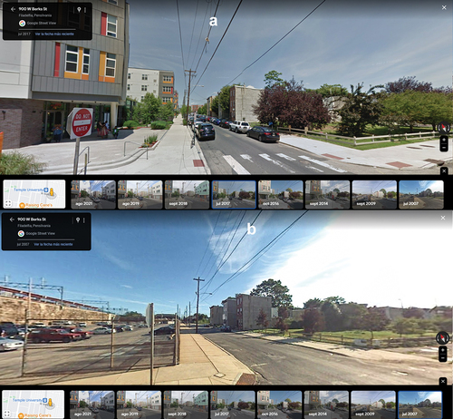
How do neighborhood changes affect health? We analyzed how to use Google Street View to study changes in neighbourhood disorder.
For the attention of: Researchers worldwide measuring changes in built environment characteristics; Organizations that want to monitor the conditions of communities living environments; Community organizations advocating to have more Google Street View images for their neighbourhoods.
The problem: Previous studies have used Google Street View to measure different features of the built environment (e.g. street condition, walkability, housing external condition and so on), and it has shown to be a valid, faster, and cheaper method compared to in-person audit.
As Google Street View started in 2007, there is a possibility now to use longitudinal Google Street View images to test how neighborhoods change over time. However, few studies have used longitudinal Google Street View images, despite its high availability in some parts of the world.
What we did and why: We conducted a feasibility study exploring image availability over time in the Philadelphia metropolitan region and describing changes in neighbourhood disorder in this region between 2009, 2014, and 2019.
Our team audited Street View images from 192 street segments in the Philadelphia Metropolitan Region. On each segment, we measured the number of images available through time, and for locations where imagery from more than one-time point was available, we collected eight neighborhood disorder indicators at three different times (up to 2009, up to 2014, and up to 2019).
What our study adds: More than 70% of street segments had more than one image in Google Street View. Thus, there is high availability of images (especially in the Philadelphia city limits) which might allow researchers to test changes in the built environment with Google Street View.
Our neighbourhood disorder index slightly increased between 2009 and 2019 in those streets where we were able to test changes with Google Street View. Future studies should explore the determinants of these changes.
Implications for city policy and practice: Our finding that Google Street View Time Machine feature could reliably identify changes in neighbourhood disorder indicates that this approach could be used to monitor the built environment or assess the impacts of change over time.
While such monitoring is only feasible in areas with high spatio-temporal availability of images, researchers and public health officials that want to use Google Street View Time Machine feature could advocate for greater availability of images across more diverse contexts.
Full research article: Measuring changes in neighborhood disorder using Google Street View longitudinal imagery: a feasibility study by Pedro Gullon, Dustin Fry, Jesse J. Plascak, Stephen J. Mooney & Gina S. Lovasi.
Measuring livability: a review of approaches in scientific research
Conceptualization of livability across studies: domains and indicators (full table in manuscript) Credit: Nishita Dsouza.
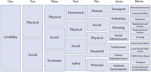
A review of livability measures found that while it is defined inconsistently, there is much overlap in approaches and indicators. Strengthening measurement can advance health-promoting urban design.
For the attention of: Civic data organizations, neighbourhood developers, professionals at intersection of urban design and community health
The problem: Investment in livability is an asset-based intervention that involves community connection, resource enhancement, and opportunity creation. Livability has been studied widely in various fields, including but not limited to urban development, economics, sustainability, and sociology. As a result, there is little consensus about livability measurement, with many different definitions and indicators used. Stronger, standardized measures of livability are needed to translate evidence-based public health recommendations that need cross-sector collaboration for successful implementation.
What we did and why: We conducted a scoping review, searching three databases (PubMed, Google Scholar, and Web of Science) for studies that measured livability. We look at whether they also assessed its measurement properties. Properties such as reliability (the consistency of a measure, or if a tool can measure something in a reproducible manner) and validity (the accuracy of a measure, or its ability to measure what was intended). We assessed how livability is measured to inform the strengthening and standardizing of measurement across sectors.
What our study adds: Studies have been carried out across the globe, with several cross-country analyses or comparisons of global cities. Most studies conducted were in an urban context. There was little consensus across studies on livability definitions. However, measure domains and indicators overlapped significantly. Most studies reported high levels of reliability and found that livability was correlated with similar measures (e.g. place satisfaction, neighborhood safety, and sense of place) and self-reported health and wellbeing.
Implications for city policy and practice: Urban policymakers are increasingly convening around the shared goal of improving livability, in an effort to collaborate more efficiently and effectively across sectors. With this scoping review we cut through the noise of academic jargon. We break down essential components of measurement science as they apply to the complex, multidimensional concept of livability with the ultimate goal of reframing livability measurement to center the everyday lives of existing residents, amplifying their priorities for future urban policies.
Full research article: Investigating the measurement properties of livability: a scoping review by Nishita Dsouza, Amy Carroll-Scott, Usama Bilal, Irene E. Headen, Rodrigo Reis & Ana P. Martinez-Donate
Green space creation and utilization linked to Healthy Cities policy in Japan: Local public-private partnerships
Green promenade along a JR Kyoto line in Suita city, 2021. Source: Miyagawa.
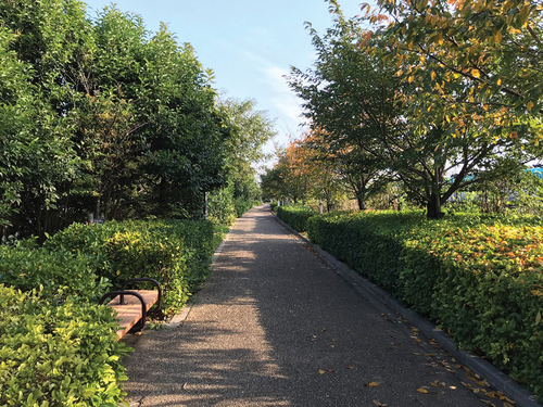
We found that through the integrated planning of public health and the provision of sufficient green spaces, the quality of the environment, particularly in disadvantaged city areas, can be significantly improved. We also determined the city size that is best suited to cross-sectoral collaboration in the planning process.
For the attention of: City officers responsible for green spaces or health promotion, particularly in Asian countries; Developers and consultants seeking to create and manage green spaces.
The problem: In Japan, green spaces have priority due to their role in disaster prevention and promote health in an ageing society. However, creating green spaces can be challenging particularly in densely populated urban areas. But we ask, how can we promote to create and promote policies of green spaces? One of the ways forward must be better collaboration of green spaces and health promotion policies. This requires joint working with different sections within the city councils.
What we did and why: We sought to clarify green spaces creation and utilization approaches as they relate to policies for Healthy Cities by examining cities in Japan that have joined the Alliance for Healthy Cities. We reviewed policies for Green Structure Plans in coordination with Health Promotion Plans and policies for Healthy Cities in six Japanese cities, and assessed the role of policies for Healthy Cities in supporting and promoting green spaces and policies for planning green spaces in these cities.
What our study adds: We found that through the integrated planning of public health and the provision of sufficient green spaces, the quality of the environment (particularly in disadvantaged city areas) may create platforms for significant improvements. Looking at city size, in terms of population, we found an interesting interplay between strengths best suited to cross-sectoral collaboration for policy development/implementation and different size cities.
Implications for city policy and practice: Partnership working is suggested for cross-sectoral collaboration. This is especially needed for effective compiling of plans and policies; as well as undertaking projects in order to bring multi-faceted benefits in promoting health. The primary aim should be to begin providing a better environment as a public service; using integrated planning that incorporates both health and environmental considerations. However, different sized cities, can play to different strengths.
Full research article: Green space creation and utilization in coordination with policies for Healthy Cities in Japan by Tomoko Miyagawa, Noriko Otsuka and Hirokazu Abe
Impacts of urban stressors on women in Mexico City
Composite urban stress for women.
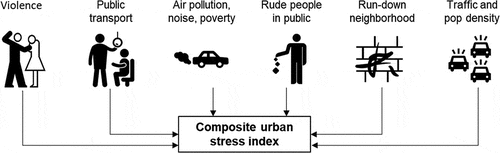
Urban stress plays an important role in women’s psychological and physical health. This serves to highlight the importance of including these, as measures, in environmental health studies. Urban interventions, such as promoting alternative transport options, should additionally be addressed to improve health of urban populations.
For the attention of: Urban and transport planners, public health professionals.
The problem: Women in urban neighbourhoods often face disproportionately higher levels of environmental and social stressors. However, the health effects from urban stressors remains poorly understood.
What we did and why: We comprehensively measured urban annoyance from environmental and social stressors in the built environment. Then we evaluated associations between urban stress and symptoms depression, fatigue, and sleep disruption in a cohort of 460 women in Mexico City.
What our study adds: We found high prevalence of annoyance overall and across several domains. We found these, in particularly, for domains related to incivilities encountered in the shared use of public spaces. We also found them in relation to lack of control over time due to driving cars, and population density. Our main findings showed associations between total perceived urban stress, and individual domains, with symptoms of depression in women.
Implications for city policy and practice: Cities offer many potential opportunities including access to health care, education, and social interactions, However, individuals in cities may also be exposed to much higher levels of environmental and social stressors. Given the rapid increases in urbanization and potential impacts on physical and mental health outcomes; it is critical that public health researchers team up with urban and transport planners to design cities that promote healthy and active lifestyles.
Full research article: Urban stress and its association with symptoms of depression, fatigue, and sleep disruption in women in Mexico City by Laura A. McGuinn, Maria José Rosa, Erika Osorio-Valencia, Iván Gutiérrez-Avila, Sandra Martinez-Medina, Homero Harari, Itai Kloog, Rosalind J. Wright, Martha Maria Téllez-Rojo, Robert O. Wright and Marcela Tamayo-Ortiz
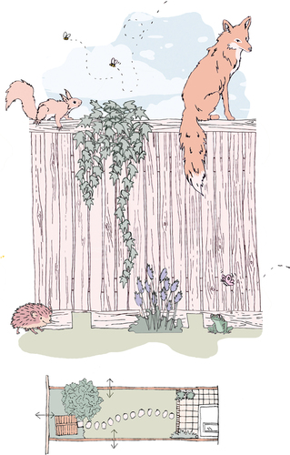
Wild Ways: understanding rewilding behaviour in urban gardens
Wildlife Gaps activity drawing. Image: Sian Moxon & Viktoria.
A review of existing research on understanding rewilding behaviour by city residents in their gardens. We undertook a scoping review of existing literature on understanding intent-orientated, pro-environmental behaviours with a focus on rewilding in urban gardens.
For the attention of: Government policymakers at national, regional, and local level; Conservation organisations; Behavioural scientists; Urban designers, architects and landscape architects.
What is the problem: Urbanisation is increasing while global biodiversity is decreasing. Through ‘urban rewilding’ cities could help tackle this biodiversity crisis, while exploiting the many benefits of urban nature for residents. Private residential gardens, which cover one quarter of UK cities, should be a primary focus We need to better understand rewilding behaviour in private gardens as an important first step towards influencing this behaviour. Small adaptations to private gardens can turn them into wildlife habitat, but understanding residents’ behaviour is critical to developing intervention strategies to enable this.
What was already known on this topic: Behaviour is context specific and therefore more research is needed to better understand how to encourage residents to make adaptations, or refrain from detrimental practices for wildlife and biodiversity.
What we did and why: Our aim was to review the existing global literature on understanding urban-rewilding behaviour in gardens, as an important first step towards positively influencing such behaviour. The literature on urban rewilding in gardens is in its infancy with the first journal publication coming in 2009; only 18 papers have been published in peer-reviewed journals between then and June 2021. No single journal is dedicated to the topic of urban rewilding with the 18 papers we found spread across 15 titles. We mapped this existing literature to assess the state of knowledge in the field. We then coded the literature, using an established behaviour model, to identify the capability, opportunity and motivation factors forming barriers and facilitators to residents engaging in rewilding activity in their gardens.
What our study adds: We mapped the existing research on understanding urban-rewilding behaviour in private gardens. We found an important body of work with implications for practice and policy to influence urban rewilding in many urban areas. From the behaviour model in the literature, we found that important elements for people were capability, opportunity and motivation factors. Our study shows that opportunity and motivation factors were most influential, and also particularly reflective motivation. However, we found the literature in this field is in its infancy, therefore more research is needed, not least in the context of London, where the next stages of our study will be focused. Understanding rewilding behaviour in private gardens is an important first step towards influencing this behaviour through practice and policy.
Implications for city policy and practice: Practice interventions should impart skills needed for residents to participate in rewilding, including an awareness of the biodiversity value of urban gardens, from an early age.
In terms of practice, projects should:
allow residents to participate at their own pace,
address concerns about time, space, funding and plant availability, and operate at community level,
highlight benefits of rewilding, including connecting with nature, educational value, creating a green retreat and helping the environment; and address concerns, including disliked species, health and safety fears and undesirable aesthetics,
show how rewilding can be compatible with residents’ functional and aesthetic preferences, and offer a trustworthy source to allay fears,
include residents with pets and different incomes.
Government should highlight the value of rewilding gardens. Policy interventions need to:
model rewilding in public spaces and around residential areas,
increase interaction opportunities with local wildlife.
Policy and practice should consider demographic factors, particularly the ethnicity-deprivation index.
For further information:
Rewild My Street. Resources and guidance for people wishing to adapt their homes, gardens and streets to encourage wildlife; and stop cities going grey
Wild Ways project: The Centre for Urban and Built Ecologies at the London Metropolitan University
Wild Ways study protocol: A study protocol to understand urban rewilding behaviour in relation to adaptations to private gardens
Full research article: Wild ways: a scoping review to understand urban-rewilding behaviour in relation to adaptations to private gardens by Siân Moxon, Justin Webb, Alexandros Semertzi & Mina Samangooei
Can walking or cycling to and from schools contribute to students’ healthy physical activity?
Walking bus station at a primary school in Esch-Belval (Luxembourg).
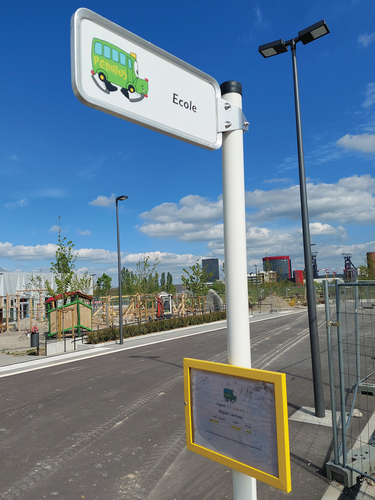
Walking and cycling to and from schools can make valuable contributions to students’ physical activity and health, according to a recent review of the scientific evidence.
For the attention of: School leaders (primary & secondary schools); local government education; planning, and health officers.
The problem: Evidence shows that many European children and adolescents fail to meet international physical activity recommended levels, increasing life-course risk of several non-communicable diseases. Policy makers and practitioners need simple, accessible, and inexpensive population-level strategies that can be integrated into students’ daily routines. Active travel to and from schools is a plausible response to children’s inactivity, although being gradually lost in some European countries.
What we did and why: Researchers and practitioners from across Europe have developed the concept of an ‘Active School’, where physical activity is embedded into many aspects of school life, including lessons, recess, and homework. Active Transport fits well within this approach as a simple, accessible, and inexpensive approach to daily activity. In developing guidance and materials to support Active Transport, we wanted to find out what had already be learned from earlier studies. So, we carried out a review of the published research from Europe.
What our study adds: This is the first European review of the physical activity benefits of Active Transport to and from schools. It offers an up-to-date account of what is known about Active Transport in Europe. It uses a specially designed reviewing method that offers a comprehensive, yet flexible collection of evidence.
Implications for city policy and practice: It is clear that children’s health is suffering due to a lack of opportunities for physical activity in cities and principalities. We recommend that:
City planners, educationalists, and health professionals need to work together to create and maintain spaces and routes for safe Active Transport.
Walking and cycling should be made the most desirable and easiest options when children and parents make decisions about travel to and from school.
For further information:
A guide for city leaders: Design to move
Healthy and Physically Active Schools in Europe (HEPAS): website
Full research article: Active transport to school and health-enhancing physical activity: a rapid review of European evidence by Richard Peter Bailey, Jana Vašíčková, Rachel Payne, Andreu Raya Demidoff and Claude Scheuer.