Abstract
We analyse a flight of post-Last Glacial Maximum terraces at Waiohine River, New Zealand that are progressively displaced by the dextral-slip Wairarapa Fault. The Waiohine River is shown to have smoothed its faulted river banks after each earthquake so that riser displacements are only recorded after abandonment of their lower bounding terrace tread. Digital elevation models produced from newly collected high-precision topographic data allowed us to precisely measure the cumulative dextral displacement of five risers and two palaeochannels, and the vertical displacement of six treads. The ratio of horizontal to vertical slip at the terraces ranges from 5.0 to 10.2 (average of 6.9±3.5 (2σ)). Combining our new displacements for the ‘Waiohine’ aggradation terrace and next younger terrace with new and previous optically stimulated luminescence (OSL) ages for Waiohine terrace silts, we calculate Late Quaternary dextral slip rates for this central part of the Wairarapa Fault of 11.9±2.9 mm a−1 (2σ) and >9.2±1.3 mm a−1 (2σ). Based on the smallest and next smallest observed offsets, the magnitudes of the inferred 1855 (smallest) and penultimate (next-smallest) single-event displacements are 12.4±0.8 m (2σ) and 9.7±1.7 m (2σ), respectively.
Introduction
The Wairarapa Fault is a major active dextral strike-slip fault in the North Island of New Zealand (). It most recently ruptured in an Mw >8.1 earthquake on 23 January 1855, over an onshore distance of c. 120 km (Rodgers & Little Citation2006). Despite this, the magnitude and distribution of its single-event displacement or its Late Quaternary slip rate remain poorly constrained. Estimates of 1855 single-event dextral displacements on the Wairarapa Fault range from as high as c. 18.5 m at Pigeon Bush on the southern part of the fault (Rodgers & Little Citation2006) to as low as 4–7 m on the Alfredton Fault, discontinuously linked to the northern end of the Wairarapa Fault (Schermer et al. Citation2004). Estimates of the Late Quaternary dextral slip rate along the central Wairarapa Fault range from 6.5 mm a−1 (Van Dissen & Berryman Citation1996) to 11.5±0.5 mm a−1 (Grapes & Wellman Citation1988; Wang & Grapes Citation2008). The uncertainties in slip rate are largely due to uncertainties in the age of the chief geomorphic marker transected by the fault, the widely post-distributed Last post-Glacial Maximum (LGM) aggradation terrace termed the ‘Waiohine’ surface.
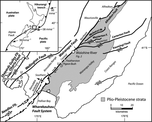
Figure 1 Major active faults in the lower North Island, New Zealand (modified from Little et al. Citation2009). Small open circles are main towns. Large open circle is area of this study (Waiohine River). Different sections of the Wairarapa Fault referred to in the text are labelled. Inset: tectonic setting of New Zealand, where Pacific plate motions are shown relative to a fixed Australian plate according to Nuvel-1a plate motion model of De Mets et al. (1990)Mets et al. (1994).
Flights of fluvial degradation terraces can provide valuable geomorphic markers of progressive fault displacements and can be used to study rates and directions of fault slip through time. To use displaced terrace risers to measure slip rates on strike-slip faults requires knowledge of how those alluvial landforms interact with the river and fault scarp, and when they begin to record fault slip. A riser is the incisional slope between two adjacent terrace surfaces. The age of a riser represents the time at which fluvial lateral erosion of that palaeo-river bank ended. Temporally, this must have taken place some time between the abandonment ages of the upper and lower terrace treads bounding that riser. However, the exact relationship between the timing and magnitude of a terrace riser displacement is commonly uncertain (e.g. Suggate Citation1960; Lensen Citation1964; Avouac Citation1993; Cowgill Citation2007; Harkins & Kirby Citation2008). The cessation of lateral erosion of a riser is most commonly assumed to occur closely in time to the abandonment of the lower bounding terrace tread (e.g. Lensen & Vella Citation1971; Little et al. Citation1998; Van der Woerd et al. Citation2002; Meriaux et al. Citation2004, Citation2005; Mason et al. Citation2006). Less often, the cessation of lateral erosion of a riser is assumed to occur more closely in time to the initial incision of the upper bounding terrace tread of that riser (e.g. Van Dissen et al. Citation2005; Zhang et al. Citation2007). Theoretical uncertainty in a riser's age results in uncertainty in a slip rate estimate. Cowgill (Citation2007) illustrates that the minimum and maximum slip rates derived from terrace riser offsets and the ages of the upper and lower bounding terraces, respectively, can vary by as little as a factor of 1.2 but commonly vary by a considerably larger factor (as large as a factor of 5).
In this study we examined a classic flight of terraces to the northeast of the Waiohine River in the central North Island, New Zealand, that have been variably displaced by the Wairarapa Fault (). The Waiohine terraces were formed by sequential downcutting of the river into previously deposited aggradation gravels of post-LGM age (Lensen & Vella Citation1971). The Waiohine terraces provide an exceptional setting in which we can study the interaction between an active fault and a flight of degradation terraces, as well as being a key site for measuring and dating rates of slip on the central section of the Wairarapa Fault. We quantify displacements of terraces, risers and palaeochannels using digital elevation models (DEMs) produced from topographic data points collected using real-time kinematic (RTK) global positioning system (GPS) and electronic distance meter (EDM) techniques. We attempt to date terraces through optically stimulated luminescence (OSL) dating of terrace sands and silts. We use our new displacement and age data together with previous OSL ages to: (1) draw conclusions about the nature of the interaction between flights of degradation terraces and active faults and determine the most valid model of progressive lateral displacements of flights of degradation terraces at the Waiohine River, allowing us to accurately assign terrace ages to the measured terrace riser displacements; (2) determine single-event displacements for the 1855 and penultimate earthquakes; and (3) derive the ratio of horizontal to vertical slip and the Late Quaternary dextral slip rate on this central part of the Wairarapa Fault.
This paper is structured to first provide the reader with background information on the tectonic setting, models of progressive fault displacement and previous geomorphologic and dating studies at the Waiohine terraces. Secondly, we describe the data collection methodology in this study and our new terrace interpretation. We follow by describing our method for determining fault displacements and a summary of our new displacement measurements. The terrace ages determined in this study are then described, followed by our discussion and conclusions.
Tectonic setting
New Zealand straddles the boundary between the Pacific and Australian plates (). Oblique subduction of oceanic crust occurs along the northeast-trending Hikurangi margin in the North Island and oblique continental collision takes place in the South Island. The southern North Island lies on the Australian plate to the west of the margin. In central New Zealand, the relative convergence rate of the Pacific plate relative to the Australian plate is c. 39 mm a−1 along an azimuth of c. 261° (NUVEL-1A of De Mets et al. Citation1990, Citation1994).
A small proportion of the margin-perpendicular component of plate motion is accommodated by shortening of the upper (Australian) plate through thrust faulting and related folding in the onshore and offshore parts of the plate (Barnes & Mercier de Lepinay Citation1997; Barnes et al. Citation1998; Nicol et al. Citation2007). The majority (>80%) of the margin-perpendicular motion is inferred to be accommodated by contractional slip on the strongly coupled subduction megathrust, which is currently locked and accumulating elastic strain at 20–25 km depth beneath Wellington (Reyners Citation1998; Darby & Beavan Citation2001; Wallace et al. Citation2004, Citation2009; Nicol et al. Citation2007).
The margin-parallel component of plate motion is largely accommodated by dextral slip on the NNE-striking faults of the North Island Dextral Fault Belt (NIDFB) (Beanland Citation1995; Mouslopoulou et al. Citation2007). In the onshore region near Wellington, dextral slip on the Shepards Gulley, Ohariu, Wellington and Wairarapa Faults () accommodates up to c. 18 mm a−1 (Beanland Citation1995) of the margin-parallel motion (e.g. Berryman Citation1990; Van Dissen et al. Citation1992; Van Dissen & Berryman Citation1996; Rodgers & Little Citation2006; Wang & Grapes Citation2008). At the surface, these faults typically dip steeply to the northwest and have a small component of reverse-slip. Seismicity data suggest that these faults intersect the subduction megathrust at depths of 20–30 km beneath the southern North Island (e.g. Reyners Citation1998). Clockwise vertical-axis rotation of eastern parts of the North Island (e.g. Wallace et al. Citation2004; Nicol et al. Citation2007; Rowen & Roberts Citation2008), strike-slip on active ENE-striking faults in Cook Strait such as the Boo Boo Fault (e.g. Barnes & Audru Citation1999; Barnes Citation2005) and oblique slip on NE-trending offshore faults including the subduction megathrust (Barnes & Audru Citation1999; Nicol et al. Citation2007) also accommodate some of the margin-parallel component of plate motion.
The Wairarapa Fault
The Wairarapa Fault is the easternmost dextral-reverse fault in the southern NIDFB, bounding the eastern side of the Rimutaka Range (). It is interpreted to have been initiated in the Pliocene as a reverse fault, and to have reactivated as a strike-slip fault at c. 1–2 Ma in response to a clockwise vertical axis rotation of the forearc relative to the Pacific Plate (Beanland Citation1995; Kelsey et al. Citation1995; Beanland & Haines Citation1998). Based on the geometry of its trace, the Wairarapa Fault can be divided into southern, central and northern sections ().
The central section, when observed at scales more detailed than 1:250,000, consists of an en echelon array of mostly left-stepping faults. These discontinuous dextral-oblique faults are separated by contractional bulges or folds in the area of their overlap that cause warping of alluvial terrace surfaces (Grapes & Wellman Citation1988; Rodgers & Little Citation2006). Rodgers & Little (Citation2006) mapped 15 individual fault strands 1200±700 m long on the southern part of the central Wairarapa Fault, separated by stepovers 400–600 m long and 20–200 m wide. Along its central section, the Wairarapa Fault forms the boundary between the greywacke of the Rimutaka Ranges and the Holocene and latest Pleistocene river gravels of the Wairarapa Valley (Grapes Citation1991). North of the Waiohine River, the northern section of the Wairarapa Fault bifurcates eastward into a series of east-northeast striking dextral splay faults () including the Carterton, Masterton and Mokonui Faults (Langridge et al. Citation2005).
Previous models for progressive fault displacement of flights of degradational terraces
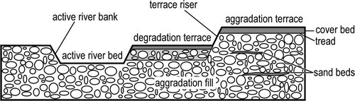
In this section, we describe three models for progressive lateral fault displacement during the formation of degradational river terraces (see also Carne Citation2009: 20–27). Comparisons between the models and our observations allow us to draw conclusions about the nature of the interaction between flights of degradation terraces and active faults, and to accurately assign terrace ages to our measured riser displacements. The first two models are end-member models that were first described by Suggate (Citation1960). The third model is a hybrid model that falls between those two end-members and was described by Lensen (Citation1964). We use Lensen's (Citation1964) terrace nomenclature (). For example, terrace tread is the nearly horizontal surface of fluvially deposited terrace gravels that represents the top surface of a now abandoned, former river bed (), and terrace riser is the steep incisional slope between two adjacent river terraces that represents a former river bank ().
Figure 2 Selected river terrace terminology for a typical section through the Waiohine River terraces. Aggradation fill/gravel is deposited by the river during times of high sediment supply, and commonly contains sand beds between thicker gravel units. The top surface of the aggradation fill is an aggradation terrace. Degradation terraces are formed by erosion/incision during subsequent river downcutting into the aggradation fill. Both aggradation and degradation terraces can be mantled by coverbeds of silt overbank deposits or loess. The tread of a terrace is the top of the terrace gravels beneath the younger coverbed.
The first end-member model (A) assumes that, after a lateral displacement on a fault, the river is unable to laterally erode or trim any of the displacement of its river banks. In this model the lateral displacement of a riser is equal to the displacement of any palaeotopographic features incised into that riser's upper bounding terrace (e.g. palaeochannels). That riser's lateral displacement is ‘fossilised’ into the landscape from the initiation of incision of that riser into its upper bounding terrace, and so the lateral displacement of that riser is most precisely dated by the age of abandonment of its upper bounding terrace tread.
Figure 3 Two-stage (slip events D1 and D2) plan view models of a degradational terrace sequence undergoing the same amount of river downcutting and lateral faulting but different amount of lateral riser trimming (modified from Lensen Citation1964). A, No lateral riser trimming; B, complete lateral riser trimming and C, partial lateral riser trimming. Bold line is the fault and half arrows indicate dextral sense of motion; toothed lines are terrace risers; thin grey line is palaeochannel; dashed line indicates displacement of riser before lateral erosion; D1 and D2 are the displacements associated with the first and second faulting events, respectively; W1 and W2 are the terrace widths on the left and right sides of the fault, respectively.
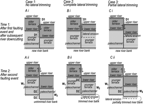
The second end-member model (B) assumes that any lateral fault displacement is followed by rapid and complete lateral erosion of the displaced riverbanks by the still-active river occupying the lower surface of that riser. Lateral erosion can result in irregularities in the terrace sequence such as uncomplemented terraces, where a displaced terrace is completely removed by erosion on one side of the fault (Suggate Citation1960). In this model, the lateral displacement of the riser (e.g. lower riser) is equal to the displacement of any palaeotopographic features incised into that riser's lower bounding terrace (e.g. palaeochannels). That riser's lateral displacement is ‘fossilised’ into the landscape from the time of abandonment of the riser's lower bounding terrace, when the river that occupied that terrace can no longer completely trim any displacement of its former river bank. The lateral displacement of the riser is most precisely dated by the age of abandonment of that riser's lower bounding terrace tread.
The third model (C), a hybrid that falls between the two end-member models, assumes that the lateral fault displacement of the river bank is later only partially eroded or trimmed by the active river. In this model, the magnitude of the lateral displacement of a riser will fall between that of the displacements of any palaeotopographic features on that riser's upper or lower bounding terraces. The age of the apparent lateral displacement of a riser is between the abandonment ages of its upper and lower bounding terrace treads.
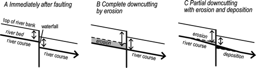
In a similar way to the strike-slip displacements, the three models also make similar predictions about the progressive accumulation of vertical displacement on faulted river terraces (e.g. Lensen Citation1964). The models (depicted in A–C) predict only small changes in the gradient of the river across the fault due to co-seismic throw and assume that, away from the fault, the regional river gradient remains the same before and after faulting. Figs. 4A–C only consider cases where the scarp is downhill-facing.
Figure 4 Cross-sectional models of a river bed and bank undergoing the same amount of vertical faulting but different amounts of river downcutting (modified from Lensen Citation1964). Here we consider only cases where the scarp is downhill facing. A, Immediately after vertical faulting with no downcutting of the fault scarp in the river bed; B, complete downcutting of the fault scarp in the river bed by erosion and C, some downcutting of the fault scarp in the river bed with erosion on the upthrown side and deposition on the downthrown side of the fault. Heavy black line is the active river bed with direction of river flow; thin black line is the top of the river bank; bold vertical line is the fault; dashed line indicates location of river bed prior to faulting; small arrows indicate height of riser on either side of the fault; light grey indicates areas of downcutting; dark grey indicates areas of deposition.
Cowgill (Citation2007) presents six geomorphic indices (summarised in ) that are useful in determining which model of progressive lateral displacement of flights of degradation terraces is most valid for a particular terrace sequence, and the most accurate age to assign to a terrace riser displacement.
Table 1 Geomorphic indices of Cowgill (Citation2007) for determining the most valid model of progressive lateral displacement of flights of degradation terraces for a particular terrace sequence.
Previous geomorphologic and dating studies at the Waiohine terraces
The Waiohine terraces northeast of the Waiohine River have been variably displaced by the Wairarapa Fault (). During the Holocene, these degradation terraces were sequentially downcut into the post-LGM Waiohine aggradation terrace (Lensen & Vella Citation1971). This is the most extensive aggradation terrace in the Wairarapa Valley, which formed by the coalescence of alluvial fans along the Tauwharenikau, Waiohine, Waingawa and Ruamahanga Rivers (Grapes Citation1991; Begg & Johnston Citation2000). In this section we describe the results of previous geomorphologic and dating studies at the Waiohine terraces.
Figure 5 Overview map of Waiohine River terraces. Wairarapa Fault trace is bold line. Unit ‘Wai’ depicts post- Last Glacial Maximum Waiohine aggradation surface. Unit ‘Po’ depicts older Porewan aggradation surface. Coordinates are in New Zealand Map Grid (NZMG).
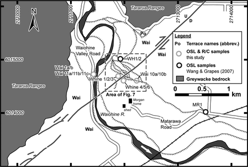
Age estimates for the Waiohine surface or similar post-LGM aggradation sequences elsewhere in New Zealand range from c. 5 ka to 30 ka (see Carne Citation2009: 151–152 for ages and references). Debate over the Waiohine surface age is largely based on the identification and/or correlation of the Waiohine (or equivalent) surface across different parts of the North Island, and the different methods used to date the surface. Three recent studies have estimated the timing of Waiohine surface abandonment from OSL and 14C dating of samples collected in the Wairarapa Valley (Formento-Trigilio et al. Citation2003; Wang & Grapes Citation2008; Little et al. Citation2009). Formento-Trigilio et al. (Citation2003) report four OSL ages between 5.12±0.37 ka and 10.5±1.2 ka for loess coverbeds on Waiohine terrace surfaces in the Huangarua River Valley, and suggest that the Waiohine terrace tread was abandoned at c. 10–12 ka. Little et al. (Citation2009) bracket the abandonment age of the Waiohine terrace between 12,400±300 cal. yr BP and 5,440±140 cal. yr BP using 14C samples collected above and below the terrace tread at Cross Creek on the southern Wairarapa Fault. Because the c. 12 ka sample was collected only 1–2 m below the terrace tread, they suggest that terrace abandonment probably occurred soon after this time. Wang & Grapes (Citation2008) present eight OSL ages between 16.1±1.6 ka and 10.0±0.9 ka for overbank silts/loess coverbeds overlying Waiohine terrace gravels from six sites on the central-southern Wairarapa Fault. Three of those samples (MR1, WH1 and WH2) were collected near the Waiohine River terraces () and yielded ages of 10.0±0.8 ka, 13.0±0.9 ka and 10.2±1.2 ka, respectively.
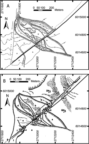
Two important previous geomorphologic interpretations of the faulted Waiohine terrace sequence are those of Lensen & Vella (Citation1971) and Grapes & Wellman (Citation1988). Lensen & Vella (Citation1971) describe a flight of eight terraces (A) referred to as A–H (A being the oldest and highest and H being the youngest and lowest of these terraces). They report seven vertical displacements, measured with a level and rod with an estimated accuracy of c. 0.15 m, and five horizontal displacements measured with a measuring tape with an estimated accuracy of c. 0.9 m. They did not identify any landforms on the Waiohine surface from which a horizontal displacement could be measured (Lensen & Vella Citation1971). Grapes & Wellman (Citation1988) mapped the Waiohine terraces using vertical aerial photos on an approximate scale of 1:17,000. They describe a flight of seven terraces – Ag3 and terraces A–F – where Ag3 is the oldest and highest Waiohine aggradation surface and terraces A–F are degradational terraces, terrace F being the youngest and lowest (B). They report seven vertical displacements and six horizontal displacements. Because their interpretive maps lack topographic contours and their displacement measurements are not accompanied by methodological explanations, survey data or assessments of uncertainty, these results are difficult to evaluate. The uncertainties for all horizontal and vertical displacement measurements were later uniformly quoted as±1 m by Grapes (Citation1999). Grapes & Wellman (Citation1988) also describe a dextral displacement for the Waiohine surface of 130 m, based on their recognition of four closely spaced channels incised into that surface (B).
Figure 6 Previous interpretations of the terraces at Waiohine River shown at the same scale. A, Interpretation by Lensen & Vella (Citation1971) and B, interpretation by Grapes & Wellman (Citation1988) including palaeochannels incised into Ag3 (Waiohine surface) displaying c. 130 m dextral displacement. Wairarapa Fault is bold line. Terrace edge/top of fault scarp is fine-toothed line. Coordinates are in NZMG.
Collection of new displacement and age data at the Waiohine terraces
In this study, we reinterpret the displacements of geomorphic features across the Wairarapa Fault at the Waiohine River terraces. We mapped the terrace sequence using c. 1:3,000 scale colour vertical aerial photographs and modern geospatial techniques. A Trimble R8 GNSS RTK GPS and a Sokkia 3030R EDM laser ranging theodolite were used to collect over 18,000 topographic data points (± 1 cm (2σ) horizontal and±18 cm (2σ) vertical precision) across the terrace sequence. The uncertainty in the vertical precision was calculated from the standard deviation of the differences in the elevation of points within 1 m of each other, collected during two different RTK GPS surveys at the Waiohine terraces. The data were krigged (i.e. gridded at a grid spacing of 1–4 m; 4 m for larger scale maps and 1 m for smaller scale individual offsets) and variously contoured using ArcMap and ArcGIS software to produce microtopographic maps or DEMs for the terrace sequence and for each specific terrace and riser displacement. From these maps, precise estimates of vertical and horizontal displacements were made from each terrace and riser, respectively.
We also attempted to construct a detailed map of the previously mentioned channels incised into the Waoihine surface that were recognised by Grapes & Wellman (Citation1988). We did this by means of an RTK GPS-based survey across the proposed site of the channels on both sides of the fault (). In addition, in hope of verifying the presence of any infilled palaeochannels, an auger survey was made across the terrace surface on the downthrown side of the fault along the base of the fault scarp, to measure the depth to the top of the Waiohine gravels in the area where Grapes & Wellman (Citation1988) mapped the four channels. Eleven auger holes were made in a fault-parallel profile ().
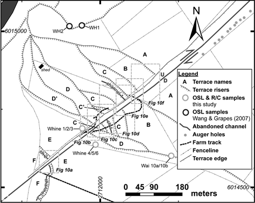
Figure 7 Geomorphologic interpretation and sample locality map of the terraces at Waiohine River based on this study. Six terraces (A–F) were identified; where terrace A corresponds to the oldest and highest aggradation terrace (Waiohine surface) and terraces B–F are degradation terraces of which terrace F is the youngest. Terraces C’ and D’ may represent locally developed palaeotopography on terraces C and D, respectively, and are not repeated on the southeast side of the fault. Distinct palaeochannels include Channel 1 (Ch1) and Channel 2 (Ch2). Wairarapa Fault is depicted by a bold line. Coordinates are in NZMG.
We collected a suite of nine OSL and two radiocarbon samples from above and below the treads of two terraces at four different sites at and near the Waiohine terraces (). The location, lithology and stratigraphic context of each sample are described later in the paper, after presentation of our new terrace map interpretation. The OSL samples were collected by inserting steel tubes into cleaned vertical cliff or pit faces. OSL samples were dated by the Victoria University of Wellington OSL Laboratory, and radiocarbon samples were dated by the University of Waikato Radiocarbon Laboratory.
New map interpretation of the Waiohine terraces
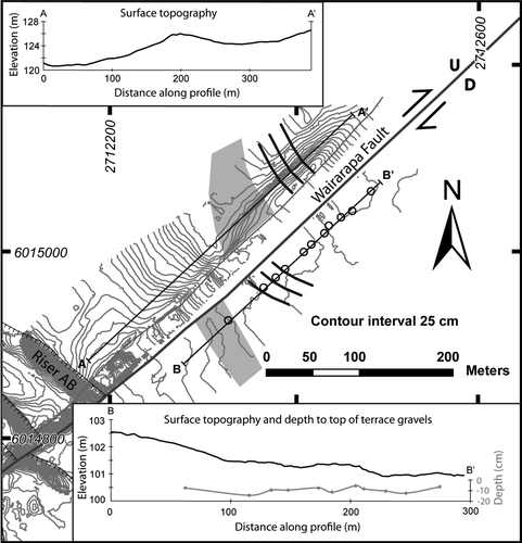
In this study, we identified six main terrace surfaces (A–F, where A is the Waiohine surface) and two indistinct or locally developed terraces (C’ and D’) (). In addition, we mapped two palaeochannels; Ch1, incised into terrace C, and Ch2, incised into terrace F (). We did not observe any horizontal displacement across the Wairarapa Fault in the modern river bank, or any vertical displacement of the modern river bed as a result of the 1855 earthquake. The risers are typically not curved in plan view in a sense that is consistent with a dextral sense of slip on the fault. The locations and trends of terrace riser segments near the fault (risers AB, BC and CD) determined in this study are different to previous studies by Lensen & Vella (Citation1971) and Grapes & Wellman (Citation1988) (A–B & 7). Neither contouring and profiling of the DEM produced from RTK GPS data collected on the Waiohine surface (our terrace A) nor the augering survey revealed any topographic evidence for the channels described by Grapes & Wellman (Citation1988) (). We found no evidence for channels in the topography of the top of the terrace gravels, as would be expected if channels had been incised into this surface. The depths to the top of the gravels ranged between just 6 cm and 15 cm for the eleven auger holes.
Figure 8 Detailed site investigation to search for evidence of palaeochannels on the Waiohine surface described by Grapes & Wellman (Citation1988). Central part of the figure shows topographic contours derived from a GPS survey of terrace A (Waiohine surface). Light grey polygons and solid black lines indicate location of palaeochannels according to Grapes & Wellman (Citation1988). Fine grey toothed line shows edge of terrace on upthrown side of Wairarapa Fault. Black toothed lines show terrace risers. Inserts show topographic profiles across the Terrace A surface on upthrown (A–A’) and downthrown (B–B’) sides of the fault. Black circles are locations of auger holes in a targeted auger survey on the downthrown side of the fault to determine the depth to the top of the Terrace A gravels (B–B’ insert in grey).
Method for determining horizontal and vertical displacements of terraces and risers
At the Waiohine River, vertical and horizontal displacements of each terrace, riser and palaeochannel across the Wairarapa Fault were measured using the method outlined below. This method assumes a complete riser trimming model in which any vertical and lateral fault displacements are followed by rapid and complete erosion of the scarp in the river bed and displaced river bank (model 2 in B & 4B), until the river finally downcuts to abandon that fully trimmed terrace and riser. A complete riser trimming model is supported at the Waiohine terraces by the lack of any horizontal or vertical displacement in the modern river bank and bed, respectively, and the observation that none of the risers are curved in a sense that is consistent with a dextral sense of slip on the fault, as might be expected under an incomplete trimming model according to the fourth index of Cowgill (Citation2007). Because the Wairarapa Fault plane is not exposed in the Waiohine River gorge, we assume a near-vertical fault plane at the Waiohine River on the basis of magnetotelluric and gravity surveys of the Wairarapa Fault (e.g. Hicks & Woodward Citation1978; Von Borstel & Ingham Citation2004).
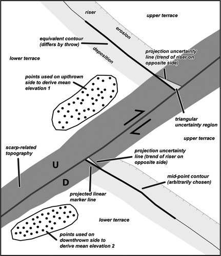
| 1. | The mean elevations of equivalent terrace treads were calculated from GPS points (usually at least 50) collected within c. 20 m of the fault scarp (). The difference in these mean elevations gives a precise vertical displacement or throw estimate, assuming negligible tilt of the terrace surfaces within c. 20 m of the fault scarp. The uncertainties in the vertical displacement were calculated as the standard error of the difference between the means of the two terrace elevations. The vertical displacements have standard errors of <9 cm at 2σ level. The uncertainties in the elevation of each data point are insignificant for this calculation because it is the relative elevations between points that are important in this study. | ||||
| 2. | The top edges of the terrace risers have probably retreated as a result of erosion at the top of each riser, and the bottom edges or toes have probably advanced by deposition of younger colluvial sediment at the base. For each riser, a contour was arbitrarily selected on the downthrown side of the fault at the midpoint of the riser, which is most likely to have remained unmodified. On the upthrown side of the fault, a matching contour was chosen that differed in elevation by exactly the throw of the riser's lower terrace surface (). These two contours are assumed to have been continuous with one another at the time of abandonment of that riser's lower bounding terrace and prior to subsequent faulting of the riser. For palaeochannels incised into terrace surfaces, the thalwegs of the channels were selected on either side of the fault. | ||||
| 3. | A polygon was drawn along the fault trace to represent the topography near the fault trace that has been modified by erosion, deposition and/or anthropogenic processes (dark grey polygon on ). The edge of the polygon was generally taken to coincide with the points in the topography where the terrace riser topographic contours deflect (often subtly) away from the main riser trend and begin to curve inwards towards the trend of the nearby fault trace. This polygon also included areas near the fault scarp where the density of GPS and EDM points was particularly low. | ||||
| 4. | We assume that the mid-riser contours (or palaeochannel thalwegs) once had an identical trend on either side of the fault where they met. This follows directly from the ‘complete trimming’ model which infers an originally linear and well-trimmed riser shape prior to faulting. Where the risers have different trends today on either side of the scarp, one or the other (or both) of the risers must have curved in such a way that they once met at the fault with the same trend (site of future fault scarp). | ||||
| 5. | The most fault-proximal segment of each preserved riser (i.e. that part nearest the fault and immediately outside of the polygon, typically within the last c. 5–10 m of it) was linearly projected to the fault trace with a trend that was parallel to the mean riser trend near the fault (). For both faulted risers and channels, the strike-slip displacement is measured as the distance between the two matched projection lines, along the trace of the fault. | ||||
| 6. | Triangular uncertainty regions were produced by drawing projection uncertainty lines on one side of the projected line segments to encompass the extreme range of curvature variations that could satisfy the assumption that the risers or thalwegs once met at the fault with the exact same trend (see step 4, above). The projection uncertainty line on one side of the fault was drawn with the same trend as the projected riser line segment for the equivalent riser on the other side of the fault (Fig. 9). These asymmetric triangular uncertainty regions are inferred to approximate 2σ confidence regions in the location of each projected riser line segment. The root-mean-square (RMS) of the two projection uncertainties (one for each riser segment on either side of the fault) approximates a 2σ confidence uncertainty (generally <3 m) for that displacement (). Any uncertainty in dextral displacement resulting from the uncertainty in the throw measurement is considered to be negligible here. | ||||
Figure 9 Method of calculating displacements as based on a complete lateral riser trimming model. (1) Mean elevations of equivalent terraces across the fault are found from GPS points close to the fault, from which the vertical displacement can be estimated (Throw = 1–2). (2) A mid-point contour is selected on the downthrown side of the fault and the equivalent contour is found on the upthrown side that differs by the vertical displacement magnitude. (3) A dark grey polygon is drawn to represent topography near the scarp that has been modified by erosion or deposition. (4 & 5) The trends of the fault-proximal parts of the risers are projected linearly across this grey area to hit the fault, giving an estimate of horizontal displacement. (6) Triangular uncertainty regions (assumed to approximate 2σ uncertainties) are determined by projecting uncertainty lines that satisfy the assumption that riser trends were once identical at the fault.
New displacement estimates for the Waiohine terraces
Cumulative displacements
Using the method outlined above, we measured cumulative vertical and dextral displacements of the Waiohine surface (terrace A) and five degradational terraces (terraces B–F) at the Waiohine River (A–F). The vertical and dextral displacements range from 1.30±0.02 m (2σ) to 19.67±0.09 m (2σ) and 11.4±1.7 m (2σ) to 101.1±3.4 m (2σ), respectively, and are listed in from the oldest and highest terrace (terrace A) to the youngest and lowest terrace (terrace F) (see Carne Citation2009: 144–145 for detailed displacement calculations). For each of the terraces in the sequence, the sense of throw was up-to-the-northwest. Our measured displacements differ from those reported by Lensen & Vella (Citation1971) and Grapes & Wellman (Citation1988) (). For all six terraces, our vertical displacements are greater than those reported in either of the previous studies by up to 1.5 m (). Our dextral displacements are within error of those from the previous studies for four of the displacements; however, our dextral displacements for risers DE and BC are c. 12 m and c. 10 m smaller, respectively, than in the previous two studies.
Figure 10 Microtopographic maps of terrace, riser and palaeochannel displacements across the Wairarapa Fault. See Fig. 3 for locations. All co-ordinates are in NZMG. A, Terrace F, riser EF and Ch2 displacements, based on c. 4900 survey points, which are omitted for clarity. B, Terrace E and riser DE displacements, based on c. 1850 survey points. C, Terrace D and riser CD displacements based on c. 2920 survey points. D, Terrace C and Ch1 displacements based on c. 3620 survey points. E, Terrace C and riser BC displacements based on c. 3540 points. F, Terrace A, terrace B and riser AB displacements based on c. 2790 points.
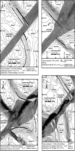
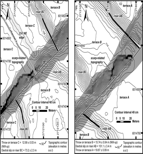
Table 2 Cumulative and incremental vertical and horizontal displacements and differences in riser heights and terrace widths across the Wairarapa Fault.
Table 3 Horizontal and vertical displacements at Waiohine River compared to results of previous studies (Lensen & Vella Citation1971; Grapes & Wellman Citation1988).
Incremental displacements
Under a model of complete riser trimming and riverbed downcutting, the incremental horizontal displacement that took place between the abandonment of two adjacent, differently displaced terraces is equal to the difference between the cumulative strike-slip of the respective risers at the back of each terrace (B). The corresponding incremental vertical displacement for two adjacent terraces is the difference between the cumulative throws of those terraces. The vertical and incremental displacements are listed in for the oldest terrace pair (terrace A and terrace B) to the youngest terrace pair (terrace F and the modern river). The uncertainties in the incremental dextral and vertical displacements were calculated as the RMS of the uncertainties of the two cumulative measurements (upper and lower terrace/riser displacements). The cumulative displacement for terrace F is interpreted to represent the single-incremental displacement that occurred during the most recent Wairarapa Fault earthquake in 1855 ().
Terrace ages at Waiohine River
Samples collected for dating of Waiohine terraces
We collected nine OSL samples and two radiocarbon samples from terraces E and B at the Waiohine River to constrain the ages of their abandonment (see & 7 for sample locations). Terrace E was dated to support our inference that palaeochannel Ch2 incised into terrace F displays a dextral displacement generated in the 1855 earthquake. Terrace B was dated to constrain the Late Quaternary slip rate on the Wairarapa Fault at Waiohine River. The location, lithology and stratigraphic context of each sample are outlined in (see Carne Citation2009: 148 for stratigraphic logs). Samples were collected from coverbeds of fluvial overbank silts deposited on the gravel terrace treads, except for sample Wai-1b which was collected from a sand layer interbedded with the fluvial terrace gravels below the tread of terrace B.
14C and OSL-based terrace ages
In this section, we summarise and interpret the results of OSL and 14C dating of terraces B and E, as displayed in (see Carne Citation2009: 39–41 for description of OSL dating technique and p. 149 for OSL age calculations). The 14C ages obtained from samples Whine 3 and Whine 6 were very young or modern suggesting that (1) the wood sample may be a root and (2) the charcoal sample collected from a charcoal-rich layer near the ground surface may have been deposited during flooding onto terrace E long after its abandonment. These 14C results are not discussed further in this paper (see Carne Citation2009: 150). The OSL ages obtained for silts (Whine 1, Whine 2, Whine 4, Whine 5) overlying the gravel tread of terrace E range from 10.1±0.9 ka (1σ) to 33.5±3.0 ka (1σ) (). The four OSL ages obtained for silts (Wai-10a, Wai-10b, Wai-11a and Wai-11b) overlying the gravel tread of terrace B range from 7.4±0.6 ka to 26.8±2.2 ka (). An OSL age of 37.9±2.4 ka was obtained for sand sample Wai-1b, below the gravel tread of terrace B ().
Table 4 Results of OSL and 14C dating of samples from the Waiohine River area.
The above OSL results are generally older than the expected abandonment ages of terraces B and E, given the most recent estimates for the abandonment age of terrace A (Waiohine surface) of c. 10–12 ka (e.g. Formento-Trigilio et al. Citation2003; Wang & Grapes Citation2008; Little et al. Citation2009). This age overestimation may have resulted from incomplete resetting of the OSL content of the grains during their final fluvial deposition, which is probably caused by a very short sediment transport distance (e.g. perhaps only a few hundred metres) or by turbid water or dim daylight conditions. Without having been exposed to sufficient light, the feldspar grains carry a remnant age lower or equal to their previous sedimentation age; this equates to the age of one of the surrounding older fluvial aggradation terraces where the grains are sourced by erosion. Sample Wai-11b () was the only sample that significantly failed the plateau test, showing clear signs of partial bleaching. It must be noted that the plateau test can only detect insufficient bleaching if most grains in a sample have seen at least some light (although not enough to reset the OSL clock). In a grain mixture where some of the grains have seen plenty of light and others none, the plateau test must fail even though we are still dealing with an age overestimation due to partial bleaching (Duller Citation1994; Duller et al. Citation1995). We conclude that most of our samples fall into the latter category and that their ages are overestimates for the abandonment age of the terrace they were collected from. For example, sample Wai-11a yielded an age for terrace B that was almost twice the age of samples collected from terrace A at this site (Wang & Grapes Citation2008). The ages obtained from 14C samples collected from terrace E were modern, despite ages between 10.1±0.9 ka (1σ) and 33.5±3.0 ka (1σ) being obtained for OSL samples from that same terrace (). These examples support the likelihood that the OSL samples were incompletely bleached. The stratigraphically reversed OSL ages of samples Whine 4 and Whine 5 suggest that these older ages are not simply due to sampling of the older aggradation terraces underlying the degradation terrace deposits.
For these reasons, we interpret the OSL age of sample Wai-1b (37.9±2.4 ka (1σ)) to be a maximum age estimate for the end of the aggradation of the Waiohine terrace. Similarly, the OSL age of sample Wai-10a collected from terrace B (14.2±1.3 ka (1σ)) is thought to provide a maximum age for the abandonment of terrace B. This sample was taken from just above the gravel tread of terrace B, and was therefore deposited soon after the abandonment of the gravel tread.
On the other hand, sample Wai-10b with an OSL age of 7.4±0.6 ka (1σ), if completely bleached, is interpreted to provide a minimum estimate of the abandonment age of terrace B, as this sample was collected c. 50 cm above the gravel tread of terrace B. However, given that the other OSL samples from terrace B appear to be incompletely bleached, the abandonment age for terrace B from sample Wai-10b must be treated as provisional.
Discussion
Interpreting progressive fault displacements at the Waiohine terraces under a complete riser trimming model
Our study at the Waiohine terraces lends support to a model of complete riser trimming, both in map view and in vertical section (B & 4B). Support for this inference comes from the following features.
| 1. | The absence of any horizontal displacement in the modern river bank or of any vertical displacement in the modern river bed, indicating that the 1855 scarp in the Waiohine River has been completely removed by the river (map view and vertical section) in the c. 150 years since that earthquake. | ||||
| 2. | The equivalence of the dextral displacements of riser EF and palaeochannel Ch2 incised into terrace F immediately below riser EF (, A), in accordance with Cowgill's (2007) second index which compares the similarity of riser and terrace tread displacements (), which suggests that riser EF only began recording displacement after its lower flanking terrace F became abandoned. | ||||
| 3. | The absence of any risers that are curved in plan view in a sense that is consistent with the sense of slip on the fault, in accordance with the fourth index of Cowgill (Citation2007). At the Waiohine terraces, none of the risers are sigmoidally curved in a dextral sense that would be consistent with the preservation of an incompletely trimmed dextral displacement. | ||||
| 4. | The differences in riser heights across the fault are equal to the vertical displacements of the riser's lower bounding terraces across the fault, as would be expected for a case of complete scarp removal by the active river after every earthquake (e.g. B). | ||||
Single-event displacements on the central Wairarapa Fault at Waiohine River
The displacements measured at the Waiohine terraces are used to interpret the number of earthquakes and the magnitude of co-seismic displacements occurring on the Wairarapa Fault since terrace formation. The vertical displacement of terrace F (1.30±0.02 m (2σ)) and the dextral displacements recorded by riser EF (11.4±1.7 m (2σ)) and Ch2 incised into terrace F (12.4±0.8 m (2σ)) are interpreted to represent co-seismic displacements that were generated during the 1855 Mw >8.1 earthquake on the Wairarapa Fault. The uncertainty in the dextral displacement of Ch2 is smaller than that of riser EF (), thus the displacement of Ch2 is assumed to more faithfully record the 1855 dextral displacement at the Waiohine terraces.
The incremental vertical displacement between terraces E and F of 1.36±0.06 m (2σ) and the incremental dextral displacement between riser DE and Ch2 of 9.7±1.7 m (2σ) are interpreted to represent displacements that were generated during the penultimate earthquake on the Wairarapa Fault. Twenty kilometres further to the south, the penultimate earthquake timing was most recently constrained as 920–800 cal. yr BP (Little et al. Citation2009). From the 1855 and penultimate single-event displacements, we infer a mean single-event dextral slip of 10.6±2.6 m (2σ) and a mean single-event throw of 1.35±0.07 m (2σ). The penultimate incremental displacements are similar to those attributed to the 1855 earthquake, suggesting that the last two events on the Wairarapa Fault had ruptures of comparable dimensions (>120 km) and magnitude (Mw c. 8) (Rodgers & Little Citation2006).
Given the above mean single-event dextral displacement, we infer that the dextral slip of riser BC (73.2±2.3 m (2σ)) resulted from an additional 4–6 earthquakes prior to the penultimate earthquake. Considering the mean single-event throw and the vertical displacement of terrace D (11.85±0.03 m (2σ)), we infer that it records slip from an additional 4–6 earthquakes that occurred after the abandonment of terrace D. Terrace C (vertically displaced by 12.99±0.03 m (2σ)) may record displacement as a result of one additional earthquake to those recorded by terrace D, occurring in the time interval between terrace C and terrace D's abandonment. Given that the dextral displacements of riser CD and riser BC are within error, it is possible that terraces C and D have experienced the same total number of earthquakes. In this case, the apparent difference in their vertical offset would have to be attributed to the lateral displacement of palaeotopography on terrace C to yield a locally higher scarp there. Considering the H/V ratio for the Wairarapa Fault (following section), it is unlikely that an earthquake on the Wairarapa Fault would result in c. 1.2 m of vertical displacement without any dextral displacement. We also infer that the vertical displacement of terrace B and the dextral displacement of riser AB occurred as a result of approximately two more earthquakes than were experienced by terrace C, and that terrace A experienced two or three more earthquakes than terrace B experienced ().
Horizontal to vertical slip ratios for the central Wairarapa Fault at Waiohine River
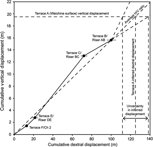
Based on the above-cited set of progressive (incremental) displacements, we infer that the ratio of horizontal to vertical slip (H/V) on the Wairarapa Fault has ranged from 5.0 to 10.2 for the Waiohine River terraces () with a mean H/V of 6.9±3.5 (2σ). The slope of each graph segment indicates the incremental H/V slip ratio for each terrace (). An H/V slip ratio could not be calculated for terrace A (Waiohine surface) as no dextral displacement was measured for that terrace. It was also impossible to calculate an H/V ratio for terrace D/riser CD due to the large uncertainty in the dextral displacement of riser CD. Instead, a combined H/V ratio for terrace C/riser BC and terrace D/riser CD was calculated. The high H/V slip ratios demonstrate the dominantly strike-slip nature of the Wairarapa Fault. Our range of H/V slip ratios for the Waiohine terraces on the central part of the Wairarapa Fault is consistent with the H/V slip ratio of c. 6–9 reported for the southern part of the fault by Rodgers & Little (Citation2006).
Although we did not identify any palaeochannel incised into terrace A, we can estimate the displacement of terrace A since its abandonment by assuming that the average H/V slip ratio for the Waiohine terraces is representative of the H/V ratio for post-terrace A displacements. Using the average H/V slip ratio for the Waiohine terraces of 6.9±3.5 (2σ) and the cumulative vertical displacement for terrace A of 19.67±0.09 m (2σ), we infer a finite dextral displacement of 129±18 m (2σ) for terrace A ().
Figure 11 Cumulative vertical versus dextral displacements across the Wairarapa Fault at the Waiohine terraces. The slope of each graph segment indicates the incremental H/V slip ratio for each terrace. Error bars are 2σ (95% confidence), error bars for vertical displacements are too small to be shown. The average H/V ratio for the Waiohine terraces is 6.9±3.5 (2σ). By projecting the vertical displacement of terrace A (Waiohine surface) of 19.67±0.09 m (2σ) across to intersect the average H/V ratio projection, a cumulative dextral displacement for terrace A of 129±18 m (2σ) is obtained.
Late Quaternary slip rate for the central Wairarapa Fault at Waiohine River
Two terraces at the Waiohine River provide displacement and age data that can be used to determine the Late Quaternary slip rate on this central part of the Wairarapa Fault. Under a complete riser trimming model, the displacement of a terrace riser is most precisely dated by the abandonment age of that riser's lower bounding terrace. The dextral displacement of riser AB is precisely known; however, the age of terrace B is only poorly constrained by results of OSL dating in this study. Conversely, the age of terrace A (Waiohine surface) is better constrained by OSL dates from Wang & Grapes (Citation2008), while the displacement for this terrace is inferred from the vertical displacement of terrace B and the average H/V ratio for the terraces.
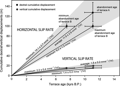
Using our inferred dextral displacement for terrace A, 129±18 m (2σ), together with an age for terrace A of 11.1±0.6 ka (1σ) calculated as the average of the three Wang & Grapes (Citation2008) OSL ages for silts deposited on that surface in the Waiohine River area, we calculate a Late Quaternary dextral slip rate of 11.9±2.9 mm a−1 (2σ) (). The vertical displacement of terrace A is 19.67±0.09 m (2σ); together with this average age for terrace A, a Late Quaternary vertical slip rate of 1.8±0.2 mm a−1 (1σ) is implied ().
Our measured cumulative displacement of riser AB, 101.1±3.4 m (2σ), together with the above-mentioned average age for terrace A as a maximum age for the abandonment of terrace B's gravel tread, yields a new minimum Late Quaternary dextral slip rate estimate of 9.2±1.3 mm a−1 (1σ) (). The vertical displacement of terrace B is 15.74±0.04 m (2σ) which, combined with this maximum age for terrace B, implies a minimum Late Quaternary vertical slip rate of 1.4±0.2 mm a−1 (1σ) (). Our measured cumulative displacement of riser AB, together with the OSL age of sample Wai-10a of 7.4±0.6 ka (1σ) as a minimum age for the abandonment of terrace B (assuming this sample is completely bleached), yields a provisional maximum Late Quaternary dextral slip rate of 14.1±2.7 mm a−1 (1σ), and a provisional maximum vertical slip rate of 2.2±0.4 mm a−1 (1σ) ().
Figure 12 Cumulative dextral and vertical displacements across the Wairarapa Fault versus terrace age for terraces A and B at Waiohine River. Black dots are dextral displacements and grey dots are vertical displacements. Error bars are 2σ (95% confidence). Error bars for vertical cumulative displacements are too small to be shown.
A number of recent studies have quantified the single-event dextral displacements and placed constraints on the Late Quaternary slip rates for different sections of the Wairarapa Fault (e.g. Van Dissen & Berryman Citation1996; Schermer et al. Citation2004; Rodgers & Little Citation2006). Variations in slip rate and single-event displacement northwards along the Wairarapa Fault are the subject of another manuscript.
Conclusions
New fault displacement and age data collected in this study at the Wairarapa Fault in the Waiohine River area provides new insights into the geomorphic expression and rate of deformation along this active strike-slip fault. Our findings are summarised by the following conclusions.
| 1. | A model of complete riser trimming is most appropriate for the Waiohine River terraces (based on similar offset of palaeochannels and adjacent risers). From this, we infer that a riser begins recording displacement when its lower bounding terrace tread is abandoned. The most appropriate trimming model for any flight of displaced river terraces should be determined from a comparison between palaeochannel and riser displacements. A comparison between riser displacements and the difference in terrace widths across the fault cannot be used to distinguish between trimming models. | ||||
| 2. | The magnitudes of the inferred 1855 (smallest displacement) and penultimate (next-smallest displacement) single-event displacements at the Waiohine terraces are 12.4±0.8 m (2σ) and 9.7±1.7 m (2σ), respectively, considerably lower than the slip estimates of 15–18.5 m measured on the southern part of the Wairarapa Fault by Rodgers & Little (Citation2006). | ||||
| 3. | Based on the age and inferred displacement of terrace A, the Late Quaternary dextral slip rate for this part of the central Wairarapa Fault is 11.9±2.9 mm a−1 (2σ). Moreover, from the displacement and maximum age for terrace B, we calculate a minimum slip rate of 9.2±1.3 mm a−1 (2σ). From the displacement and minimum age for terrace B, we calculate a provisional maximum slip rate of 14.1±2.7 mm a−1 (1σ). The ratio of horizontal to vertical slip ranges from 5.0 to 10.2 for the Waiohine River terraces, with an average of 6.9±3.5 (2σ). | ||||
Supplementary Material
Download PDF (1.2 MB)Acknowledgements
We thank David Rhoades, Russ Van Dissen and Pilar Villamor for insightful discussions regarding statistical analysis of terrace ages and Wairarapa Fault tectonics, Ningsheng Wang for the preparation and processing of OSL samples, Mark Henderson for technical help with GPS data collection and processing and Hannu Seebeck, Dave Murphy, Dee Ninis, Keely Schreiber and the Colorado College undergraduate field trip students for their efforts surveying. We also thank Dave Rodgers and Pilar Villamor for helpful comments on an earlier draft, Nicola Litchfield and Mark Quigley for their extensive manuscript reviews and Simon Cox for his exceptional editorial efforts.
Related Research Data
References
- Avouac , J . 1993 . Analysis of Scarp Profiles: Evaluation of Errors in Morphologic Dating . Journal of Geophysical Research , 98 ( B4 ) : 6745 – 6754 .
- Barnes PM 2005 . The southern end of the Wairarapa Fault, and surrounding structures in Cook Strait . In : Townend J, Langridge RM, Jones A (comps) The 1855 Wairarapa Earthquake Symposium: 150 years of thinking about magnitude 8+ earthquakes and seismic hazard in New Zealand: 8–10 September 2005: proceedings volume . Wellington, NZ : Greater Wellington Regional Council , p. 66 – 71 .
- Barnes , PM and Audru , J-C . 1999 . Quaternary faulting in the offshore Flaxbourne and Wairarapa Basins, southern Cook Strait, New Zealand . New Zealand Journal of Geology and Geophysics , 42 : 349 – 367 .
- Barnes , PM and Mercier , de Lepinay B . 1997 . Rates and mechanics of rapid frontal accretion along the very obliquely convergent southern Hikurangi margin, New Zealand . Journal of Geophysical Research , 102 ( B11 ) : 24,931 – 24,952 .
- Barnes , PM , Mercier de Lepinay , B , Collot , J-Y , Delteil , J and Audru , J-C . 1998 . Strain partitioning in the transition area between oblique subduction and continental collision, Hikurangi margin, New Zealand . Tectonics , 17 : 534 – 557 .
- Beanland S 1995 . The North Island dextral fault belt, Hikurangi subduction margin, New Zealand . Unpublished Ph. D. thesis, Victoria University of Wellington, New Zealand: 341 p.
- Beanland , S and Haines , J . 1998 . A kinematic model of active deformation in the North Island, New Zealand, determined from geological strain rates . New Zealand Journal of Geology and Geophysics , 41 : 311 – 324 .
- Begg JG , Johnston MR 2000 . Geology of the Wellington Area, New Zealand . Institute of Geological and Nuclear Sciences Ltd. 1:250,000 Geological Map 10 .
- Berryman , K . 1990 . Late Quaternary movement on the Wellington Fault in the Upper Hutt area, New Zealand . New Zealand Journal of Geology and Geophysics , 33 : 257 – 270 .
- Bronk Ramsey C 2005 . OxCal v.3.10 . http://www.rlaha.ox.ac.uk/orau/calibration.html .
- Carne RC 2009 . Rates and Styles of Late Quaternary Deformation on the Wairarapa Fault, North Island, New Zealand . Unpublished M.Sc. thesis, Victoria University of Wellington, New Zealand. URL: http://researcharchive.vuw.ac.nz/handle/10063/1104 .
- Cowgill , E . 2007 . Impact of riser reconstructions on estimation of secular variation in rates of strike–slip faulting: Revisiting the Cherchen River site along the Altyn Tagh Fault, NW China . Earth & Planetary Science Letters , 254 : 239 – 255 .
- Darby , DJ and Beavan , J . 2001 . Evidence from GPS measurements for contemporary interplate coupling on the Southern Hikurangi subduction thrust and for partitioning of strain into the upper plate . Journal of Geophysical Research , 106 ( B12 ) : 30881 – 30891 .
- DeMets , C , Gordon , RG , Argus , DF and Stein , S . 1990 . Current plate motions . Geophysical Journal International , 101 : 425 – 478 .
- DeMets , C , Gordon , RG , Argus , DF and Stein , S . 1994 . Effect of recent revisions to the geomagnetic reversal time scale on estimates of current plate motions . Geophysical Research Letters , 21 : 2191 – 2194 .
- Duller , GAT . 1994 . Luminescence dating of poorly bleached sediments from Scotland . Quaternary Science Reviews , 13 : 521 – 524 .
- Duller , GAT , Wintle , AG and Hall , AM . 1995 . Luminescence dating and its application to key pre–late Devensian sites in Scotland . Quarternay Science Reviews , 14 : 495 – 519 .
- Formento-Trigilio , ML , Burbank , DW , Nicol , A , Shulmeister , J and Rieser , U . 2003 . River response to an active fold-and-thrust belt in a convergent margin setting, North Island, New Zealand . Geomorphology , 49 : 125 – 152 .
- Grapes , RH . 1991 . Aggradation surfaces and implications for displacement rates along the Wairarapa Fault, southern North Island, New Zealand . Catena , 18 : 453 – 469 .
- Grapes , RH . 1999 . Geomorphology of faulting: the Wairarapa Fault, New Zealand . Zeitschrift fur Geomorphologie , 115 : 191 – 217 .
- Grapes , RH and Wellman , HW . 1988 . The Wairarapa Fault. Victoria University of Wellington, New Zealand . Geology Board of Studies , 4 : 54
- Harkins N , Kirby E 2008 . Fluvial terrace riser degradation and determination of slip rates on strike-slip faults: An example from the Kunlun fault, China . Geophysical Research Letters , 35 , L05406 , doi: doi: 10.1029/2007GL033073 .
- Hicks , SR and Woodward , DJ . 1978 . Gravity models of the Wairarapa region, New Zealand . New Zealand Journal of Geology and Geophysics , 21 ( 5 ) : 539 – 544 .
- Kelsey , KM , Cashman , SM , Beanland , S and Berryman , KR . 1995 . Structural evolution along the inner forearc of the obliquely convergent Hikurangi margin, New Zealand . Tectonics , 14 : 1 – 18 .
- Langridge RM , Van Dissen RJ , Cochran UA , Litchfield NJ , Berryman KR , Begg JG , Villamor P , Heron D , Nicol A , Townsend D 2005 . Active Faulting and paleoearthquakes in the Wairarapa and Wellington regions . p. 49 – 65 . In: Townend J, Langridge RM, Jones A (comps) The 1855 Wairarapa Earthquake Symposium: 150 years of thinking about magnitude 8+ earthquakes and seismic hazard in New Zealand: 8–10 September 2005: proceedings volume . [Wellington, NZ]: Greater Wellington Regional Council .
- Lensen , GJ . 1964 . The general case of progressive fault displacement of flights of degradational terraces . New Zealand Journal of Geology and Geophysics , 7 : 864 – 870 .
- Lensen , GJ and Vella , P . 1971 . The Waiohine River Faulted Terrace Sequence in Recent Crustal Movements . Royal Society of New Zealand Bulletin , 9 : 117 – 119 .
- Little , TA , Grapes , R and Berger , GW . 1998 . Late Quaternary strike slip on the eastern part of the Awatere fault, South Island . New Zealand: Geological Society of America Bulletin , 110 ( 2 ) : 127 – 148 .
- Little , TA , Van Dissen , R , Schermer , E and Carne , R . 2009 . Late Holocene surface ruptures on the southern Wairarapa Fault, New Zealand: Link between oblique-reverse earthquakes and the raising of beach ridges on a rocky coast . Lithosphere , 1 ( 1 ) : 4 – 28 .
- Mason , DPM , Little , TA and Van Dissen , RJ . 2006 . Rates of active faulting during late Quaternary fluvial terrace formation at Saxton River, Awatere Fault, New Zealand . Geological Society of America Bulletin , 118 ( 11/12 ) : 1431 – 1446 .
- McCormac , FG , Hogg , AG , Blackwell , PG , Buck , CE , Higham , TFG and Reimer , PJ . 2004 . SHCaIO4 Southern Hemisphere calibration, 0-11.0 cal Kyr BP . Radiocarbon , 46 : 1087 – 1092 .
- Meriaux A-S , Ryerson FJ , Tapponnier P , Van der Woerd J , Finkel RC , Xiwei X , Zhiqin X , Caffee MW 2004 . Rapid slip along the central Altyn Tagh Fault: Morphochronologic evidence from Cherchen He and Sulamu Tagh . Journal of Geophysical Research 109 , B06401 , doi: doi: 10.1029/2003JB002558 .
- Meriaux A-S , Tapponnier P , Ryerson FJ , Xiwei X , King G , Van der Woerd J , Finkel RC , Haibing L , Caffee MW , Zhiqin X , Wenbin C 2005 . The Aksay segment of the northern Altyn Tagh Fault: tectonic geomorphology, landscape evolution, and Holocene slip rate . Journal of Geophysical Research 110 , B04404 , doi: doi: 10.1029/2004JB003210 .
- Mouslopoulou , V , Nicol , A , Little , TA and Walsh , JJ . 2007 . Displacement transfer between intersecting regional strike-slip and extension fault systems . Journal of Structural Geology , 29 : 100 – 116 .
- Nicol A , Mazengarb C , Chanier F , Rait G , Uruski C , Wallace L 2007 . Tectonic evolution of the active Hikurangi subduction margin, New Zealand, since the Oligocene . Tectonics , 2 , TC4002 , doi: doi: 10.1029/2006TC002090 .
- Reyners , M . 1998 . Plate coupling and the hazard of large subduction thrust earthquakes at the Hikurangi subduction zone, New Zealand . New Zealand Journal of Geology and Geophysics , 41 : 343 – 354 .
- Rhoades D , Van Dissen R , Little T , Litchfield N Carne R Villamor P , manuscript in preparation . Conditional probability of rupture of the Wairarapa and Ohariu faults, New Zealand. To be submitted to New Zealand Journal of Geology and Geophysics .
- Rodgers DW , Little TA 2006 . World's largest co-seismic strike-slip offset: The 1855 rupture of the Wairarapa Fault, New Zealand, and implications for displacement/length scaling of continental earthquakes . Journal of Geophysical Research , 111 , B12408 , doi: doi:10.1029/2005JB004065 .
- Rowen CJ , Roberts AP 2008 . Widespread remagnetizations and a new view of Neogene tectonic rotations within the Australia–Pacific plate boundary zone, New Zealand . Journal of Geophysical Research , 113 , B03103 , doi: doi: 10.1029/2006JB004594 .
- Schermer , ER , Van Dissen , R , Berryman , KR , Kelsey , HM and Cashman , SM . 2004 . Active faults, paleoseismology, and historical fault rupture in northern Wairarapa, North Island . New Zealand Journal of Geology and Geophysics , 47 : 107 – 122 .
- Stuiver , M and Polach , HA . 1977 . Discussion: reporting of 14C data . Radiocarbon , 19 : 355 – 363 .
- Suggate , RP . 1960 . The interpretation of progressive fault displacement of flights of terraces . New Zealand Journal of Geology and Geophysics , 3 : 364 – 374 .
- Van der Woerd , J , Tapponier , P , Ryerson , FJ , Meriaux , AS , Meyer , B , Gaudemer , Y , Finkel , RC , Caffee , MW , Zhao , G and Xu , Z . 2002 . Uniform postglacial slip-rate along the central 600 km of the Kunlun Fault (Tibet), from 26Al, 10Be, and 14C dating of riser offsets, and climatic origin of the regional morphology . Geophysical Journal International , 148 : 356 – 388 .
- Van Dissen , RJ and Berryman , KR . 1996 . Surface rupture earthquakes over the last ∼100 years in the Wellington region, New Zealand, and implications for ground shaking hazard . Journal of Geophysical Research , 101 : 5999 – 6019 .
- Van Dissen , RJ , Berryman , K , Pettinga , JR and Hill , NL . 1992 . Paleoseismicity of the Wellington–Hutt Valley Segment of the Wellington Fault, North Island, New Zealand . New Zealand Journal of Geology and Geophysics , 35 : 165 – 176 .
- Van Dissen RJ , Little TA , Nicol A 2005 . Faults of Eastern Marlborough: Picton, Awatere and Kekerengu . p. 85 – 110 . In : Pettinga JR Wandres AM Field Trip Guides, Geological Society of New Zealand 50th Annual Conference, Kaikoura, New Zealand. Geological Society of New Zealand Misc. Publ. 119B .
- Von Borstel , OI and Ingham , M . 2004 . Imaging the Wairarapa Fault at Tauwharenikau using magnetotelluric sounding . New Zealand Journal of Geology and Geophysics , 47 : 281 – 286 .
- Wallace L , Beavan J , McCaffrey R , Darby D 2004 , Subduction zone coupling and tectonic block rotation in the North Island, New Zealand . Journal of Geophysical Research , 109 , B12406 , doi: doi: 10.1029/2004JB003241 .
- Wallace LM , Reyners M , Cochran U , Banister S , Barnes P , Berryman K , Downes G , Eberhart-Phillips D , Nicol A , Mccaffrey R , Beavan J , Ellis S , Power W , Henrys S , Sutherland R , Litchfield N , Townend J , Robinson R , Barker DHN , Wilson K 2009 . Characterizing the seismogenic zone of a major plate boundary subduction thrust: Hikurangi Margin, New Zealand . Geochemistry, Geophysics, Geosystems , 10 , Q10006 , doi: doi:10.1029/2009GC002610
- Wang , N and Grapes , R . 2008 . Infrared-stimulated luminescence dating of late Quaternary aggradation surfaces and their deformation along an active fault, southern North Island of New Zealand . Geomorphology , 96 ( 1–2 ) : 86 – 104 .
- Zhang P-Z , Molnar P , Xu X 2007 . Late Quaternary and present-day rates of slip along the Altyn Tagh Fault, northern margin of the Tibetan Plateau . Tectonics , v. 26 , TC5010 , doi: doi: 1029/2006TC002014 .