
ABSTRACT
Late Early–Late Cretaceous strata preserved at the northeastern end of the Waiau Toa/Clarence valley, northeastern South Island, New Zealand, have been central to ongoing debates concerning the end of Mesozoic subduction on the Zealandian margin of Gondwana and the initiation of extension. New geological mapping within this area at Coverham, Kekerengu and Wharekiri, has resolved complex relationships between Cretaceous stratigraphic units and faults. Results indicate that, within the interval 110–100 Ma, Champagne and lower Split Rock formations record syn-tectonic deposition by marine mass-transport processes within confined sub-basins with steep seafloor gradients. Upper Split Rock Formation and overlying Nidd Formation record progressive burial of seafloor topography between c. 100–86 Ma. Although uncertainties remain, three or four faults appear to have been low-angle structures with normal displacements that were active within the interval c. 105–89 Ma; one of these faults experienced brief reversal of offset between c. 91 and 87 Ma. The new data are most consistent with a model of subduction shutdown between c. 105–100 Ma, following impact of the Hikurangi Plateau large igneous province at the subduction margin. Widespread uplift along the margin between 97 and 95 Ma may reflect subsequent rebound of the subducted plate.
Introduction
From the Permian to the Cretaceous, Zealandia occupied a position on the Pacific-facing margin of Gondwana and was the site of active subduction and accretion. Subduction ended sometime in the Late Cretaceous, perhaps following collision of the Hikurangi Plateau large igneous province, and was followed by regional extension and Gondwana breakup. Despite much research, however, the configuration of Cretaceous tectonic plates in the region and the timing of subduction termination are still debated, with estimates of subduction shutdown ranging from c. 105 to c. 70 Ma (see recent reviews and cited literature in Crampton et al. Citation2019; Mortimer et al. Citation2019; Laird and Bradshaw Citation2020; van de Lagemaat et al. Citation2023). Cretaceous strata that span this tectonic transition are well preserved and exposed around the northeastern end of the Waiau Toa/Clarence River valley in the Marlborough–north Canterbury region, northeastern South Island, New Zealand (NZ). (Henceforth the valley name is simplified to the widely cited ‘Clarence valley’.) This region lies within the southernmost part of the Cretaceous to Neogene East Coast Basin (, inset; see Field et al. Citation1997). The tectonic transition corresponds to the so-called ‘basement/cover’ stratigraphic contact of many previous workers and, in the nomenclature of Mortimer et al. (Citation2014), the contact of the Austral Superprovince and overlying Zealandia megasequence (). For over a century, strata at the northeastern end of the Clarence valley have been central to inferences about NZ’s Cretaceous geological history, but still, recent discussions draw very different conclusions regarding their tectonostratigraphic interpretation (cf. Laird and Bradshaw Citation2020; Gardiner and Hall Citation2021; and see early discussion in Wellman Citation1959, pp. 130–131). Ongoing debate reflects, in large part, the complexity of the geology and the fact that, despite almost 150 years of study, key formations and their stratigraphic and structural relationships have never been described adequately. The present contribution addresses these knowledge gaps.
Figure 1. Location of the study area in northeastern South Island, NZ, showing geographic localities and geological features discussed in the text. Faults are shown as solid black lines, and key faults of the Marlborough fault system are labelled. Red polygons indicate areas shown in detail in (A = Coverham, B = Kekerengu, C = Wharekiri, respectively). The ‘middle Clarence’ moniker denotes areas of the Clarence valley lying south and southwest of Tapuae-o-Uenuku (e.g. Reay Citation1993). The grid is the NZ Transverse Mercator 10-kilometre grid. The geology is simplified from Rattenbury et al. (Citation2006). Inset shows the location within NZ and key faults of the Australia/Pacific plate boundary, including those of the Marlborough fault system.
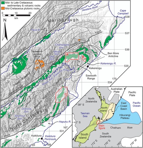
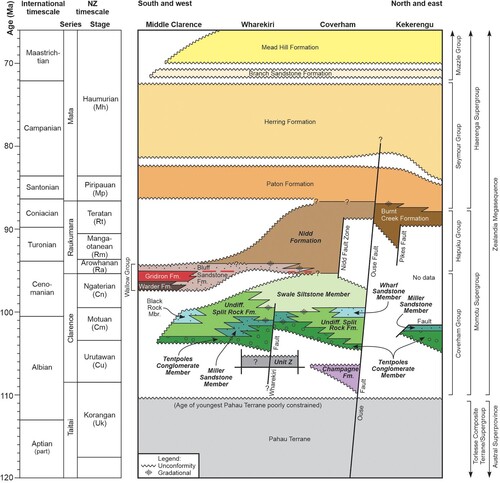
Figure 2. Lithostratigraphic nomenclature and rock relationships of Cretaceous units in the Clarence valley and immediate environs. Names in bold italics are units described here. Split Rock Formation is indicated in shades of green (Tentpoles Conglomerate, Miller Sandstone, Black Rock, Wharf Sandstone, and Swale Siltstone members). ‘Undifferentiated Split Rock Formation’ includes strata mapped previously as Ouse Member/Formation and Cold Stream Member (see text). Red lines within Bluff Sandstone and Nidd formations indicate minor occurrences of Gridiron Formation volcanic rocks. Relationships for the middle Clarence area are modified from Reay (Citation1993). Age relationships for the Paton and Herring formations are simplified and adapted from Crampton et al. (Citation2000, Citation2006). The geological timescale is from Raine et al. (Citation2015). Group-level nomenclature is modified from Rattenbury et al. (Citation2006) and higher-level lithostratigraphic nomenclature follows Mortimer et al. (Citation2014).
Alexander McKay, the first geologist to examine the area around Coverham at the northeastern limit of the Clarence valley (), recognised the significance of the Cretaceous succession there, as reflected in his repeated use of the epithet ‘the Great Coverham section’ (McKay Citation1886, p. 71, p. 77; McKay Citation1890, p. 150, and elsewhere). At the same time, Hector (Citation1886) stated that the area has ‘a more complete sequence of the Upper Secondary strata present than in any other part of New Zealand’ (p. xiv). This claim was repeated subsequently by Thomson (Citation1919), who argued that ‘An almost continuous section of the [Cretaceous] beds has been observed [at Coverham], and no faults of any consequence were seen’ (p. 315). Results presented here support some of these early observations: Coverham truly preserves one of the most complete late Early–Late Cretaceous successions known in NZ. Contra Thomson, however, it is affected by numerous faults. This succession has been preserved within a small area through fortuitous quirks of stratigraphic accumulation and syn-sedimentary tectonics.
The present paper, therefore, presents new interpretations of the geology and stratigraphy at Coverham (, polygon A), with additional data from two other nearby, important areas: a small part of the Kekerengu River valley (, polygon B) and the Wharekiri Stream valley and environs (, polygon C). The new data are used to:
Resolve complex tectonostratigraphic patterns within and between hitherto poorly described formations (Champagne, Split Rock and Nidd formations).
Clarify the nature of several faults that were apparently active during the Cretaceous and determine the timing of this activity.
Interpret these faults and significant unconformities in the context of wider Zealandian Cretaceous tectonic history.
Previous work
Coverham lies within the catchment of Ouse Stream (a tributary of the Waiau Toa/Clarence River; ) and, as noted above, has been studied by geologists for well over a century. This is not the place for a detailed account of earlier work, but previous geological maps and/or stratigraphic interpretations covering some or all of the Coverham area can be found in McKay (Citation1886), Woods (Citation1917), Thomson (Citation1919), Cotton (Citation1955), Wellman (Citation1955), Hall (Citation1963, Citation1964), Gair (Citation1967), Henderson (Citation1973), Lensen (Citation1978), Ritchie (Citation1986), Crampton and Laird (Citation1997), Crampton et al. (Citation1998), Crampton, Hollis, et al. (Citation2004), and Hasegawa et al. (Citation2013). The area has been key to development of NZ Cretaceous biostratigraphic schemes and the local geological time scale (e.g. Wellman Citation1959; Hall Citation1963; Henderson Citation1973; Speden Citation1977; Cooper et al. Citation2004) and, recently, the carbon isotope excursion close to the Cenomanian/Turonian boundary has been identified there (Hasegawa et al. Citation2013; Gangl et al. Citation2019). Some of the diverse and rich fossil collections from the area have been described by Woods (Citation1917), Wilckens (Citation1922), McQueen (Citation1956), Wright (Citation1957), Henderson (Citation1973), Crampton (Citation1996), and Cantrill and Raine (Citation2006). Interpretations of the stratigraphic succession at Coverham vary widely between the papers cited above, and a comparison of some earlier lithostratigraphic subdivisions is given in figure 2 of Crampton and Laird (Citation1997). The present contribution has built very much on the insights of earlier workers. In particular, key advances in understanding were the recognition by Hall (Citation1963) of major lithostratigraphic contrasts between southeastern and northwestern parts of Coverham, and the identification by both Hall (Citation1964) and Ritchie (Citation1986) of a thick, highly deformed and enigmatic unit lying stratigraphically between undoubted basement and cover units in Ouse Stream (in part, Hall’s ‘Pikes formation’ and Ritchie’s ‘Champagne member’).
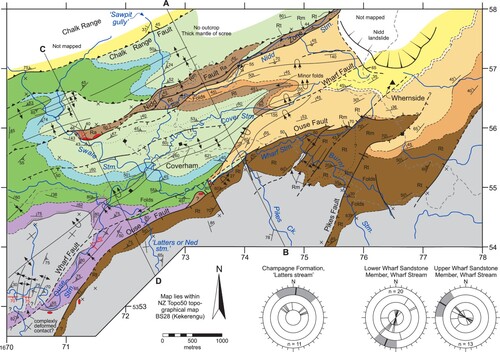
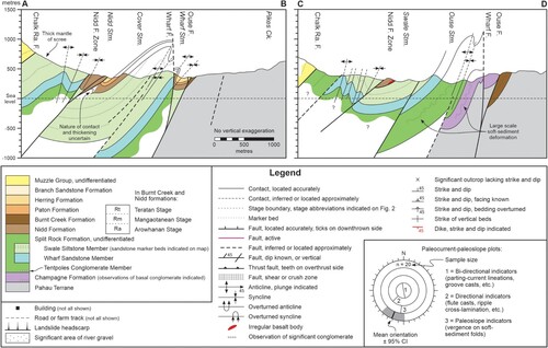
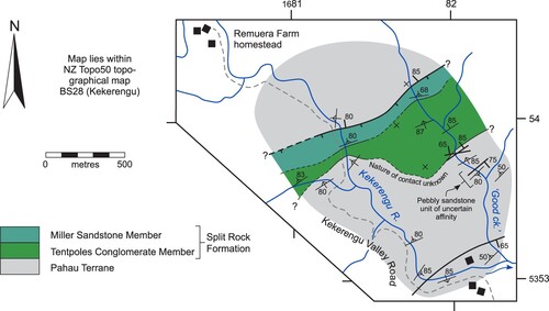
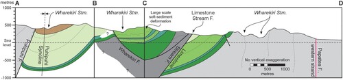
Figure 3. Geological map and cross-sections of the Coverham area (polygon ‘A’ on ). Also shown are paleocurrent and paleoslope plots for Champagne Formation and Wharf Sandstone Member (Split Rock Formation). The locations of all geological observations and fossil records are shown in Figure S1, and the locations of measured sections are shown in Figure S2 (figures with prefix ‘S’ refer to Supplementary Material). On the cross-sections, form-lines are arbitrary and serve only to illustrate intraformational structures.
The Kekerengu valley, although much less studied than Coverham, likewise has a long history of geological exploration. The conglomeratic cover unit mapped here (), although omitted from some recent geological maps (Prebble Citation1976; Rattenbury et al. Citation2006), was recorded by McKay (Citation1890) and Ritchie (Citation1986), and possibly Macpherson (Citation1952) and Lensen (Citation1962). Importantly, McKay (Citation1890, pp. 170–171) recognised that it is separated from underlying basement by an unconformity. Macpherson (Citation1952) may have observed the conglomerate unit in the Kekerengu valley and used it to mark the contact between his Whernside Group and overlying Good Creek Sandstone. If so, however, his observations are misplaced some 250 m downstream and he misinterpreted the younging direction and stratigraphic relationships of these strata (and see comments about this in Wellman Citation1955). Ritchie (Citation1986) mapped this and other conglomerate bodies and, although he regarded them as part of the Pahau Terrane (his Sawtooth Group), he did note that the outcrops in the Kekerengu valley are weakly deformed relative to most Pahau strata (p. 86).
Figure 4. Geological map of the Kekerengu area (polygon ‘B’ on ). Geological symbols are explained in . The locations of measured sections are shown in Figure S2.
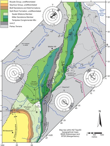
In contrast to Coverham and Kekerengu, impressive and important stratigraphic exposures in the Wharekiri valley and environs () have received virtually no detailed study. Previous geological surveys are limited to unpublished stratigraphic sections logged by Malcolm Laird and others (NZ Geological Survey) in the 1980s (and see brief descriptions in Laird Citation1992) and the recent publication of a stratigraphic section by Gardiner and Hall (Citation2021). Note that some exposures in Wharekiri Stream were significantly obscured by rockfalls following the November 2016, Kaikōura earthquake.
Figure 5. Geological map and cross-section of the Wharekiri area (polygon ‘C’ on ). Also shown are paleocurrent and paleoslope plots for Split Rock Formation in different sections and the informal ‘Unit Z’. Geological symbols are explained in . The locations of measured sections are shown in Figure S2. The line of the cross-section is constrained, in part, by availability of useful outcrop control. On the cross-section, form-lines are arbitrary and serve only to illustrate intraformational structures. Affinities of strata mapped as Unit Z are unclear (see text).
Methods
This paper focusses on three formations that are emended herein, Champagne, Split Rock, and Nidd formations, and includes brief descriptions of Pahau Terrane and the informal ‘Unit Z’ (). Additional notes on these units are included in the Supplementary Material. Other units that appear on the geological maps () have been described thoroughly elsewhere, and references are provided in the Supplementary Material.
Geographic localities are specified using abbreviated, six-figure NZ Transverse Mercator 2000 grid references, prefixed with ‘GR’; the studied areas lie on NZTopo50 1:50,000 topographical map sheets BS28 (Kekerengu) and BT28 (Mangamaunu). The following informal but widely used labels for otherwise unnamed streams are retained here: ‘Sawpit gully’, ‘Latters stream’ (both ) and ‘Good creek’ (). The distribution of field observations around Coverham is shown in Figure S1 (figures with prefix ‘S’ refer to Supplementary Material). Compass bearings are given with respect to modern true north and no attempt is made here to describe palinspastic configurations (cf. Crampton et al. Citation2003; Hines et al. Citation2022; Strogen et al. Citation2022).
All stratigraphic sections were measured using compass and 50 m tape or, in a few places, a Nikon Forestry 550 laser rangefinder. True thickness of strata has been calculated trigonometrically using measured bedding attitudes. The locations and names of measured sections are shown in Figure S2, the legend for all sections is given in Figure S3, and annotated section logs are given in Figures S4–S10. Detailed sedimentary facies analysis is beyond the scope of this study, although the areas mapped have superb exposures of a broad array of facies that would repay detailed investigation. A large number of facies classifications have been proposed for gravity flow deposits, and interpretations of transport and depositional processes vary widely. For simplicity and consistency, reconnaissance-level facies descriptions herein use the nomenclature and associated interpretations of Pickering and Hiscott (Citation2016), and readers should refer to that publication for more detailed discussion of relevant facies.
Throughout the text, geological ages are given in terms of the stages of the NZ geological timescale (Raine et al. Citation2015); correlations of these stages to the international timescale are shown in . For convenience, in the text the informal term ‘mid-Cretaceous’ is used to denote late Early to early Late Cretaceous time, the Urutawan to Teratan NZ stages (c. 108–86 Ma; and see Bengtson and Kakabadze Citation2018). Fossil localities are described using their registration numbers in the NZ Fossil Record File (henceforth, ‘FRED’; Clowes et al. Citation2020), using the format ‘P30/f123’, where ‘P30’ refers to the (now obsolete) NZMS260 series map sheet, and ‘f123′ refers to a unique fossil locality number within that sheet.
Paleocurrent and paleoslope indicators have been restored to horizontal assuming no plunge on major folds. Paleoslope indicators are derived from soft-sediment fold axis orientations and vergence; paleocurrent estimates are based on flute and groove casts, asymmetrical ripple crests, and parting current lineations. Mean paleocurrent vectors are Fisher mean vectors, shown with their 95% confidence intervals, calculated using the software Stereonet v. 10.0.6 (Allmendinger et al. Citation2011; Cardozo and Allmendinger Citation2013); for calculation of mean vectors, bidirectional paleocurrent indicators (groove casts and parting current lineations) are assumed to indicate flow direction within the hemicircle containing associated directional current indicators (flutes casts, etc.).
Other details of methods can be found in the Supplementary Material.
Lithostratigraphy
Pahau Terrane
Following Rattenbury et al. (Citation2006), the oldest, basement-forming rocks within the study area are assigned to undifferentiated Pahau Terrane of the Torlesse Composite Terrane (; for an explanation of terrane nomenclature, see Mortimer et al. Citation2014). Around the northern end of the Clarence valley, these strata comprise mainly moderately to intensely deformed, indurated, massive quartzofeldspathic fine–very fine sandstone, thick intervals of interbedded, graded sandstone and mudstone, and massive mudstone. Available data suggest a Korangan or older (>c. 108 Ma), Early Cretaceous age for these rocks. Detailed description of Pahau Terrane is beyond the scope of this study; further brief discussion of key lithologies and other distinctive but volumetrically minor rock types, age data, and interpretations of depositional environment can be found in the Supplementary Material.
‘Unit Z’ (informal)
The informal name ‘Unit Z’ is used for a strip of distinctive strata in the Wharekiri area that are bounded on their eastern side by the Limestone Stream Fault and, to the west, overlain unconformably by Split Rock Formation ( and see below). These strata comprise sandstone-dominated, decimetre- to metre-interbedded, sandstone and mudstone (Figure S9B). Sandstone beds typically are graded, display well-preserved sedimentary structures including parallel and ripple cross-lamination, and commonly have flute and groove casts on their bases. The age of these rocks is poorly constrained and their affinity is ambiguous. In terms of induration, jointing and deformation, they resemble overlying Split Rock Formation, although it is also possible that they represent comparatively young and weakly deformed parts of Pahau Terrane. Other notes on Unit Z are given in the Supplementary Material.
Champagne Formation (emended)
Type section, original description, and emended definition
This unit was established by Ritchie and Bradshaw (Citation1985) and Ritchie (Citation1986) as the lowest member of Split Rock Formation in the Coverham area. It was named from ‘Champagne stream’ (informal name, ) and described from representative outcrops in Ouse Stream to include a succession of interbedded sandstone, mudstone, and minor conglomerate that is locally very intensely and characteristically deformed. Importantly, building on the work of Hall (Citation1964), Ritchie was the first to argue that the unit is distinct from Pahau Terrane and has an unconformity-bounded, stratiform distribution that parallels the overlying Cretaceous cover succession. Subsequent authors have regarded it as a formation in its own right or as a member of Split Rock Formation (Crampton and Laird Citation1997; Crampton et al. Citation1998; Crampton, Tulloch, et al. Citation2004; Rattenbury et al. Citation2006), but it has never been adequately described in print. Here it is considered to be of formation rank and the type section of Ritchie (Citation1986) is retained; this section is well exposed in both banks of Ouse Stream, from GR712539 to GR717547 (part of the Ouse-Nidd section, Figures S2A and S5B).
Distribution, thickness, and relationships to underlying units
Champagne Formation is known with certainty from the area of the type locality only, northwest of the Ouse Fault, where it is 190 m thick (Figures 3, 6 and S5B). Ritchie (Citation1986) inferred that the unit extends beneath a large area to the northwest of Ouse Stream, but much of this is now thought to represent Split Rock Formation, although Champagne Formation certainly does extend some distance further up the Clarence valley from the area shown in (i.e. towards the southwest; see Rattenbury et al. Citation2006). Potential correlations of the formation to units further afield are discussed in the Supplementary Material.
The basal unconformity of Champagne Formation is overlain by a conglomerate bed. In the area of the type locality, beds either side of the basal contact appear to be approximately parallel (e.g. Figure S11A), although intense deformation of strata below and above mean that any angular discordance is hard to determine in outcrop or at map scale; further south, the unconformity is likely to be angular (in Mead and Dee streams, shown on ; Ritchie Citation1986; pers. obs.).
Content
Champagne Formation is dominated by indurated, centimetre- to 10 m-interbedded, sandstone and mudstone, and minor conglomerate (Figure S5B). Sandstone is typically medium to very fine grainsize, but up to coarse grainsize at the base of thicker beds. Mudstone-dominated intervals are massive or regularly and characteristically centimetre-bedded, and form much of the lower half of the formation (Figures 7A, S5B and S11B–C). In the upper part, ridge-forming, thick-bedded sandstone dominates (beds up to 2.5 m thick; Figure S11G). Basal conglomerate is polymict, matrix- to clast-supported and mostly disorganised; clasts are typically rounded to well-rounded and pebble to cobble size, but include boulders and sandstone rafts up to 10 m long in places. This conglomerate bed varies from a few metres to c. 15 m thick within the mapped area (Figure S11A; observations of this bed indicated on ), and is over 50 m thick just beyond the western map boundary (around GR690537). Additional notes about all these lithologies are provided in the Supplementary Material.
In the area of its type locality, Champagne Formation is characterised by pervasive, intense deformation that suggests a complete spectrum from ductile to brittle mechanisms. Deformation is much less pronounced low in the formation in Latters stream, which exposes a gradient from weakly deformed strata in the southeast (GR724544) to very strongly deformed rocks in the west (GR719546) (compare Figures S11B, 7A and S11C–E). Deformation fabrics include boudinage, broken formation, mesoscopic faulting, detached and disharmonic folds, and ball-and-pillow structures (see Supplementary Material). In outcrop, parts of the unit appear as a chaotic mélange or completely ‘blended’.
Paleontology and age
Finer-grained parts of Champagne Formation contain relatively common marine macrofossils, mainly inoceramid bivalves, including a species with affinities to early Albian Anopaea mandibula? from the Northern Hemisphere (late Korangan, c. 113–108 Ma; P30/f880). Dinoflagellates from this sample may also indicate a latest Aptian to early Albian age (c. 120–108 Ma; Crampton, Tulloch, et al. Citation2004, p. 10). Further age control is given by Korangan ages for the youngest detrital zircon populations in two sandstone samples collected from Champagne Formation in Ouse Stream (samples 23 and 24 of Adams et al. Citation2013; and see comments on the provenance of sample 24 in Crampton et al. Citation2019). Taken together and given that overlying strata are no older than latest Urutawan (c. 105–103 Ma), Champagne Formation must have been deposited within the age range late Korangan–Urutawan (c. 113–103 Ma) and much of the protolith is likely to be late Korangan. Additional notes on the paleontology of this unit are given in the Supplementary Material.
Environment of deposition
Based on the thickness of Champagne Formation (and thus the accommodation space required), the scale and nature of chaotic deformation, and the presence of marine fossils, large parts of this unit are inferred to represent the products of a mass-transport complex sensu Pickering and Corregidor (Citation2005) that was redeposited by sedimentary-gravitational mass-transport processes into a bathyal or deeper marine environment. Much of the formation comprises slide/slump facies (Ogata et al. Citation2020), but comparatively coherent parts of the formation in Latters stream may represent in situ beds or parts of large, internally little-deformed slide blocks. Intra-formational beds of disorganised conglomerate are interpreted as debris flow facies (Pickering and Hiscott Citation2016; Ogata et al. Citation2020) that may mark boundaries between discrete mass-wasting events (e.g. c. 90 m on Figure S5B). Further notes on the depositional environment of Champagne Formation are provided in the Supplementary Material.
Split Rock Formation (emended)
Type section, original description, and emended definition
Split Rock Formation was introduced by Suggate (Citation1958) to accommodate Clarence Series conglomerate, sandstone, and mudstone in the Seymour Stream area in the middle Clarence valley (; and see Reay Citation1993). Following Ritchie (Citation1986) and Rattenbury et al. (Citation2006), the concept of this formation is expanded to encompass a distinctive, thick, mudstone-dominated and generally fining-upwards succession of conglomerate, interbedded sandstone and mudstone, and mudstone, of Clarence Series age, that is distributed in a series of fault-controlled outcrops through the Clarence valley and east to the coast. This definition emphasises region-wide similarities in composition and stratigraphic architecture; I acknowledge the possibility that lower parts of the formation may represent laterally disconnected bodies that occupy discrete depocentres. A new reference section is proposed here at Coverham, in the Ouse-Nidd section, extending from GR717547 in Ouse Stream to GR727562 in Nidd Stream (Figures 3, S2A and S5).
The lower half of the formation is characterised by abrupt and dramatic lateral facies changes and, in places, the fining-upwards pattern is interrupted by packages enriched in sandstone. Several members are discriminated (see ); some of these were regarded by earlier workers as formations in their own right (e.g. Lensen Citation1978, see in particular his figure 6.28). The following members are described here: Tentpoles Conglomerate, Miller Sandstone (new), Wharf Sandstone, and Swale Siltstone. Undifferentiated parts of Split Rock Formation comprise mudstone with subordinate centimetre- to decimetre-interbedded sandstone; included here are strata mapped formerly as Ouse Siltstone Formation/Member (Lensen Citation1978; Ritchie Citation1986) and Cold Stream Member (Reay Citation1993).
Distribution, correlation, thickness, and relationships to underlying units
As noted above, Split Rock Formation is distributed widely in the Clarence valley and east to the coast (Rattenbury et al. Citation2006). At Coverham, it is restricted to areas northwest of the Ouse Fault. The name should be used also for at least some correlative strata within the Awatere valley to the west (), but relationships to rocks mapped there as Gladstone and Winterton formations and undifferentiated Coverham Group are not examined here (but see Challis Citation1966; Lensen Citation1978; Rattenbury et al. Citation2006; Gardiner and Hall Citation2021; Gardiner et al. Citation2022).
Importantly, Split Rock Formation is the southernmost representative of a suite of fining-upwards, mudstone-dominated, Clarence to Raukumara Series units that extend the length of the East Coast Basin. Included here are Gentle Annie and Springhill formations in central-western parts of the basin (Moore and Speden Citation1979, Citation1984; Johnston Citation1980; Crampton Citation1989), and Karekare, Te Wera, and Oponae Mélange formations (amongst others) in northwestern parts of the basin (Speden Citation1973, Citation1975; Feary Citation1979; and see a general stratigraphic overview in Field et al. Citation1997). Notwithstanding facies variations in the lower half of the formation, noted above, and the presence of local unconformities (e.g. Crampton et al. Citation2019), these formations are remarkably uniform in general appearance and facies succession and were almost certainly part of a single, widespread depositional tract.
A maximum total thickness has not been measured for Split Rock Formation, but it is >1260 m thick in the Coverham area (Figures 6 and S5), where the upper part is truncated by a fault, and >1700 m thick in the middle Wharekiri section, where it is truncated by an angular unconformity (Figures 8 and S9). In the upper Limestone Stream section, Wharekiri, the formation has a total thickness of approximately 650 m but, again, here it is truncated by an angular unconformity. Variations in thickness of Split Rock Formation are controlled substantially by variations in the thickness of basal coarse facies (Tentpoles Conglomerate and Miller Sandstone members) and erosional truncation of the upper part of the formation (see below).
In Coverham, Split Rock Formation disconformably overlies Champagne Formation. Elsewhere, Split Rock Formation overlies either Pahau Terrane or the informal Unit Z with marked angular unconformity (, and ) and up to at least 10 m of basal relief (Figure S8B). Where measured, the angular discordance is between c. 30° and 130° (i.e. overturned) (see Supplementary Material). Typically, basal Split Rock Formation is conspicuously less indurated, jointed, and veined than underlying Pahau Terrane rocks (this is particularly obvious in the Kekerengu and lower Wharekiri sections).
Content
Split Rock Formation is dominated by mudstone and contains significant proportions of interbedded sandstone-mudstone and conglomerate, and very minor amounts of limestone and probable altered tuff. Members are defined on the basis of variations in the proportions of these rock types, as detailed below. Undifferentiated parts of the unit contain between a few per cent and less than c. 20%, centimetre- to decimetre-interbedded sandstone, estimated over a 50 m interval, and minor conglomerate (Figures 7B and S12A–D). Measured sections through Split Rock Formation are summarised in and , and shown in more detail in Figures S5 and S7–S10.
Mudstone is finely laminated to apparently massive and is typically dark olive-grey (wet) in lower parts of the unit and somewhat paler, medium olive-grey in upper parts. Where present, laminations in mudstone are defined by carbonaceous material and, in many places, by millimetre-scale partings of siltstone, very fine sandstone or disaggregated inoceramid bivalve prisms. Mudstone is assigned mostly to facies E1.1 (structureless muds), E1.3 (mottled muds) and E2.2 (laminated muds) of Pickering and Hiscott (Citation2016). Pyrite nodules are common locally, in particular associated with fossils. Elliptical, calcareous, mudstone concretions up to 2 m across are common in higher parts of the formation (Figure S14G), and thin concretionary horizons, layers of calcareous nodules, and layers of cone-in-cone carbonate occur in places. Trace fossils including Anconichnus, Chondrites, Phycosiphon,?Planolites and possible Teichichnus, were observed in some mudstone outcrops.
Sandstone is typically medium olive-grey (wet), and medium- to very fine-grained, although coarse- to very coarse-grained and pebbly sandstone is present in the lower parts of many thicker beds. It is commonly carbonaceous, with comminuted carbonaceous material concentrated on laminations. In undifferentiated parts of the formation, sandstone forms beds that range in thickness from centimetres to decimetres, but beds may be up to 5 m thick in Wharf Sandstone Member (see below). Some sandstone beds are massive, but they are more typically graded, parallel-, wavy-, cross- or convolute-laminated. Partial Bouma sequences (Bouma Citation1962) occur throughout – commonly Tb to Td – and sandstone-mudstone couplets mostly represent a range of facies within group C2 of Pickering and Hiscott (Citation2016; and see member descriptions below). Sandstone bedding-plane exposures of asymmetric ripples, with sinuous to lunate crestlines, are present in the lower and middle Wharekiri sections, where they are associated with decimetre-thick beds of climbing ripples that, at a given outcrop, indicate approximately consistent paleoflow directions (GR682325, GR677320 and GR661304; Figure S12F; and see later discussion of paleocurrent data). Flute and groove casts, flame structures and irregular sole structures occur on the bases of many beds. Most sandstone beds appear tabular in outcrop, but lenticular, channelised beds that erode up to several decimetres into underlying strata are not uncommon.
Conglomerate in Split Rock Formation is highly variable in character (Figures 7C and S13B–D) (note that here, for convenience, I use the conglomerate label to include dilute, pebbly-bouldery mudstone). Conglomerate is clast- to matrix-supported, with pebble- to boulder-sized clasts and rafts typically up to 2 m across (but see description of Tentpoles Conglomerate Member, below), within coarse sandstone to mudstone matrix; commonly, clast density varies laterally and vertically within beds. Smaller clasts are polymict and tend to be well-rounded; in some beds they are conspicuously polished. Clast compositions include quartz, red chert, dark volcanic lithologies, plutonic lithologies, and rhyolite. Clasts larger than pebble size are rounded to angular and comprise sandstone and lesser mudstone; some of these seem to be intrabasinal whereas many are clearly derived from underlying Pahau Terrane. Conglomerate is mostly poorly sorted and disorganised (i.e. lacking any conspicuous clast fabric), although crude coarse-tail normal or inverse grading may be evident in some beds. In places conglomerate is more clearly organised, individual beds are weakly to moderately well stratified on a decimetre to metre scale, and clast populations may be well sorted. Conglomerate forms individual or amalgamated beds from centimetres to 100 m or more thick; in places beds are channelised, with up to several metres of erosive basal relief (Figure S12C). Conglomerate beds represent a spectrum of facies A1.1, A1.3, A1.4, and A2 of Pickering and Hiscott (Citation2016); detailed description of these varied coarse-grained facies is beyond the scope of the present study.
Other distinctive, but volumetrically insignificant rock types within Split Rock Formation include probable zeolitized tuff and sandy limestone. The tuff forms conspicuous, white to pale greenish beds up to 30 cm thick, and mostly <3 cm thick, which are relatively common particularly in upper parts of the formation at Coverham. Impure limestone beds up to 20 cm thick and lags at the base of some sandstone beds are composed largely of current-aligned calcite prisms derived from the disaggregated shells of inoceramid bivalves, and have been observed in the Ouse Stream area (e.g. GR718549, P30/f2463 at GR731548, and 238 m in Figure S5B at GR718548) and lower Wharekiri section (around 470 m in Figure S8 at GR676318).
Split Rock Formation displays widespread evidence of syn-sedimentary slumping and deformation and, particularly in the lower half of the unit, substantial thicknesses may be largely or entirely affected. Evidence includes non-cylindrical and disharmonic, soft-sediment folding in packets up to 10 m or more thick, broken bedding, dislocated rafts of sandstone, and ball-and-pillow and injection structures (e.g. Figures 7B, S12D–E and S14B–C; see Supplementary Material). Within some beds there are gradations vertically and laterally between slumped intervals, dilute pebbly sandstone and mudstone, and clast-supported conglomerate.
Tentpoles Conglomerate Member (emended)
Type section, definition, distribution, thickness, and relationships to underlying units: Tentpoles Conglomerate Member was defined by Reay (Citation1987) from a type section in Seymour Stream, in the middle Clarence valley (), to include conglomerate that unconformably overlies Pahau Terrane (and see Reay Citation1993). Herein, the concept of the member is extended to include conglomerate-dominated, lower parts of Split Rock Formation, with variable but subordinate amounts of sandstone and mudstone, that crop out widely across the Clarence–Wharekiri–Kekerengu valleys (and see the Supplementary Material).
The measured thickness of this member varies from a minimum of 8 m in Ouse Stream (Figure S5; too thin to show on ) to over 420 m in the middle Wharekiri section (Figures 5, 8 and S9A). In places, large changes in thickness occur over a short distance: the member is 31 m thick in Kekerengu River and apparently thickens to 380 m in Good creek over a distance of c. 550 m (Figures 4 and S10). Likewise, in Wharekiri Stream it thickens from c. 70 m east of Wharekiri Fault to 420 m immediately northwest of the fault (Figures 5, 8, S8 and S9A).
In all places examined here, Tentpoles Conglomerate Member overlies the basal unconformity of Split Rock Formation, as described previously.
Content. In most respects, conglomerate, sandstone and mudstone in Tentpoles Conglomerate Member match the descriptions given already for the formation. In the middle Wharekiri section, a zone of indurated and deformed, thinly bedded sandstone and mudstone >150 m thick by >300 m long may represent one or more megaclasts within the conglomerate (Figures 5 and S9), as described in the middle Clarence area (Reay Citation1993). In the same section, smaller megaclasts that are clearly enclosed by bouldery mudstone have dimensions of at least 2 m by 10 m.
Other intervals of interbedded, centimetre- to metre-interbedded sandstone and subordinate mudstone in Tentpoles Conglomerate Member are in stratigraphic succession and up to a few tens of metres thick. Of note are several large bedding-planes of rippled sandstone, between thicker beds of conglomerate, that are exposed in the lower Wharekiri section (GR682324; Figure S13E). A few of these bedding planes show approximately symmetrical ripples, with sinuous crestlines, and suggest wave-influence, although no clear evidence for oscillatory flow has been observed in ripple cross-sections (Figure S13F). Also of note are decimetre-thick sets of sandstone cross-beds in the lower Wharekiri Stream and Kekerengu River sections (GR683326 and GR813538, respectively), which are assigned to facies B2.2 of Pickering and Hiscott (Citation2016).
Miller Sandstone Member (new)
Type section, definition, distribution, thickness, and relationships to underlying units: Miller Sandstone Member is defined here as sandstone-rich parts of Split Rock Formation overlying Tentpoles Conglomerate Member in the Wharekiri Stream, Miller Stream, and Kekerengu valley areas (and see the Supplementary Material). By definition it includes sequences with > c. 20% sandstone over any 50 m interval, variable proportions of mudstone, and subordinate conglomerate. The type section is defined in Miller Stream, from the conformable contact with underlying Tentpoles Conglomerate Member at GR691349, to the gradational contact with overlying undifferentiated Split Rock Formation at GR684346 (Figures 5 and S7B–D). Here it is c. 260 m thick (although this measurement is confounded somewhat by structural complication), and it thins towards the south, where it apparently interfingers with undifferentiated Split Rock Formation (). In places, the contact with underlying Tentpoles Conglomerate Member is apparently gradational (e.g. the lower Wharekiri section, although here the contact is affected by a fault; Figure S8). South of Wharekiri Fault, Miller Sandstone Member is only c. 50 m thick (Figures 5, 8 and S9C).
Content: Again, in most respects, sandstone, mudstone and conglomerate in Miller Sandstone Member match descriptions given for the formation. Sandstone beds are centimetre- to 1.5 m thick. Fifty centimetre-thick cross-bed sets and wavy, low-angle cross-beds were observed in a few sandstone beds in Miller Stream (GR688348) and are assigned to facies B2.2 of Pickering and Hiscott (Citation2016). Barite nodules within mudstone have been noted at a few places. Conglomerate and pebble-rich slump units, in beds up to 9 m thick, form approximately 15% of the upper part of the member in the type section (e.g. around GR 685346; Figure S7D), but these coarse facies typically comprise a smaller component of most sections.
Wharf Sandstone Member
Type section, definition, distribution, thickness, and relationships to underlying units: The name ‘Wharf Gorge sandstones’ was used by Woods (Citation1917) and Thomson (Citation1919) for distinctive, sandstone-rich, interbedded sandstone and mudstone that was described from a section in Wharf Stream, Coverham (from GR726551 to GR725553; Figures 3 and 7D). The unit was included in Wellman’s (Citation1955) mixed litho- and biostratigraphic subdivision of the Coverham succession, was regarded as a formation in its own right by Lensen (Citation1978), and described as Wharf Sandstone Member of Split Rock Formation by Ritchie (Citation1986). The latter usage is retained here for an interval comprising > 40% sandstone averaged over any 50 m interval. Wharf Sandstone Member is known only from Coverham ( and ); it is not well exposed in the Ouse-Nidd section, but is well exposed in its nearby type section. Here it is 110 m thick and overlies undifferentiated Split Rock Formation with a contact that is gradational over c. 2 m and marked by a distinctive horizon of 20 cm diameter, spherical mudstone concretions that may indicate a condensed interval or minor omission surface.
Content. Wharf Sandstone Member comprises centimetre- to 5 m-interbedded sandstone and mudstone, as described previously. In the type section, sandstone bed thickness is characteristically bimodal through much of the unit, with c. 1–5 m thick sandstone beds separated by mudstone-dominated intervals containing multiple, centimetre–30 cm thick sandstone beds (Figures 7D and S14E). Other details are given in the Supplementary Material.
Swale Siltstone Member (emended)
Type section, definition, distribution, thickness, and relationships to underlying units: The concept of this unit was introduced, without formal definition, by Lensen (Citation1978) as both ‘Swale Siltstone’ and ‘Swale Formation’. The name has been used by subsequent workers for mudstone-dominated, upper parts of Split Rock Formation that include negligible proportions of sandstone (e.g. Ritchie Citation1986; Crampton et al. Citation1998). This concept is retained here, and a type section is defined from Nidd Stream, Coverham, from close to its junction with Swale Stream to a fault near the mouth of Sawpit gully (GR723554 to GR727562; part of the Ouse-Nidd section, Figures 3, S2 and S5A). This concept of the unit is essentially equivalent to the informal ‘Sawpit (Gully) Mudstone’ of Woods (Citation1917) and Hall (Citation1964) and ‘Cover Creek mudstones’ of Thomson (Citation1919) and Woods (Citation1917; and see Crampton and Laird Citation1997, their figure 2). Swale Siltstone Member is known from the Coverham and Wharekiri areas (see Supplementary Material).
Swale Siltstone Member is at least 720 m thick in the type section (Figures 6 and S5A); here, the top of the section is affected by one or more faults and stratigraphic relationships are unclear (see description of Nidd Formation, below). In the Wharekiri area the member is >500 m thick (Figures 8 and S9A), although all sections are truncated either by faults or an angular unconformity.
In the area of its type section, Swale Siltstone Member overlies Wharf Sandstone Member with a contact that is gradational over c. 3 m and marked by a horizon of calcareous concretions and nodules that may mark a minor condensed horizon (Figure S14D; see Supplementary Material). In the Wharekiri area, northwest and east of Wharekiri Fault, Swale Siltstone overlies undifferentiated Split Rock Formation with a contact that is gradational over a substantial stratigraphic thickness such that location of the boundary in the field is rather subjective. South of Wharekiri Fault, Swale Siltstone overlies Miller Sandstone Member with a contact that is gradational over a few metres.
Content: Swale Siltstone Member is composed almost entirely of massive to weakly decimetre- to metre-bedded mudstone, with minor proportions of sandstone and very minor conglomerate (lithologies described above, and see Figures 7E, S5A, S9A, C and S14G–H). Whereas some or much of the mudstone appears massive or entirely bioturbated, fresh, water-washed outcrops reveal that some of it at least is very regularly laminated on a millimetre scale. Elsewhere, there is evidence for soft-sediment deformation including disrupted, folded, and wispy lamination, and dish-and-pillar structures, and some of the mudstone could represent facies C2.5 (slurried deposits) of Pickering and Hiscott (Citation2016). Large, elliptical to tabular, septarian, calcareous, mudstone concretions up to 2 m across are characteristic of the member and are commonly arrayed parallel to bedding (Figures 7E and S14G).
Sandstone comprises c. 2% of the Swale Siltstone Member, is mostly fine to very fine grainsize, and is scattered throughout in beds that range mostly from millimetre-scale laminations up to 20 cm thick. Low-angle wavy lamination is visible in some beds, which may also have coarse gritty lags composed of sand-sized mud rip-up clasts or fossil debris. Most sandstone beds, however, display partial Bouma sequences, comprising intervals Tb–Te, and they are inferred to represent mainly isolated instances of facies C2.2 and C2.3 of Pickering and Hiscott (Citation2016) within a mud-dominated system. A single, 30 cm-thick, pebble conglomerate-breccia bed 90 m below the top of the type section (1390 m in Figure S5A, GR726561) marks the base of a facies change to centimetre-interbedded, laminated mudstone, siltstone and minor very fine sandstone (see details in the Supplementary Material).
Paleontology and age
Well-preserved marine macrofossils are abundant within Split Rock Formation and are dominated by biostratigraphically useful inoceramid bivalves, although a significant diversity of other groups has been recorded (see the Supplementary Material). Of the microfossil groups, foraminifera have been little studied (but see Wellman Citation1955), are typically sparse, poorly preserved and dominated by agglutinated forms, but locally are well preserved and age-diagnostic (e.g. P30/f122). In contrast, terrestrial and marine palynofloras are abundant, commonly moderately well to well preserved, and provide important age control in outcrops lacking macrofossil data (e.g. P30/f720, f1424, f6692; see the Supplementary Material). In sum, abundant biostratigraphic data indicate that Split Rock Formation may be latest Urutawan age at its base (<c. 105 Ma), in places at least, but it is largely Motuan–Ngaterian (c. 103–95 Ma). The age of the base of Split Rock Formation may vary substantially from place to place, and lower parts of the unit may have been deposited over short time spans. The upper boundary of the Motuan (c. 99 Ma) is coincident approximately with the top of the Wharf Sandstone and Miller Sandstone members. Additional age control is provided by the youngest population of detrital zircons from basal Miller Sandstone Member in Kekerengu River, which indicates a maximum depositional age of 104 ± 1 Ma (latest Urutawan; sample 22 of Adams et al. Citation2013; and see reinterpretation of the provenance of this sample in Crampton et al. Citation2019, appendix 2).
Environment of deposition
Split Rock Formation records deposition across a range of paleoenvironments. According to the interpretations of Pickering and Hiscott (Citation2016), varied conglomerate facies within Split Rock Formation are likely to have been transported and deposited by high-energy, submarine gravity flow processes including concentrated density flows, inflated sand and gravel flows, and debris flows. Interbedded sandstone and mudstone are inferred to have been deposited mainly by a spectrum of processes transitional between concentrated density flows and turbidity currents. In the upper part of the formation, Swale Siltstone Member records a marked decrease in energy and deposition of mudstone likely by mud-laden turbidity currents, mudflows, suspended load within bottom currents, and hemipelagic settling from the overlying water column. Further discussion of these interpretations is given in the Supplementary Material.
Water depth of deposition of Split Rock Formation is hard to determine. Near the base of the formation, possible wave-formed ripples in Tentpoles Conglomerate Member in the lower Wharekiri section may suggest deposition above wave-base, at least locally. Likewise, near the top of the formation, within Swale Siltstone Member, there is equivocal evidence for tempestites that may indicate occasional wave reworking above storm wave-base (see the Supplementary Material). Through most of Split Rock Formation, however, the absence of typical shallow-water fossils, the predominance of sediment gravity flow deposits, and the absence of obvious wave-formed sedimentary structures, all suggest deposition below storm wave-base. Furthermore, the apparent thickness of individual conglomerate units within Tentpoles Conglomerate Member and the presence of one or more inferred megaclasts >150 m thick, suggest water depths of at least hundreds of metres for some parts of lower Split Rock Formation.
Abundant and spectacular evidence for widespread mass-transport and syn-sedimentary slumping in the lower part of the formation indicates large-scale gravitational collapse on or adjacent to over-steepened and unstable submarine slopes, high sediment accumulation rates on those slopes and, almost certainly, seismic shaking and syn-tectonic deposition (e.g. Claussmann et al. Citation2021). Thicker parts of Tentpoles Conglomerate Member are best characterised as mass-transport complexes. The inference of syn-tectonic deposition during the latest Urutawan–Motuan (c. 105–99 Ma) is supported by the pattern of stratigraphic thickening adjacent to structures such as the Wharekiri Fault, discussed in more detail below. Abrupt lateral thickness variations in Tentpoles Conglomerate Member can also be explained, in part, by deposition adjacent to submarine canyon margins, as observed at the base of the lower Wharekiri section (see the Supplementary Material). Deposition within a complex, confined and evolving paleotopography is confirmed by paleocurrent estimates from the lower half of Split Rock Formation that are highly variable, both spatially and up-sequence ( and , and see the Supplementary Material). The fining-upwards nature of the formation and deposition of relatively homogenous Swale Siltstone Member in the Ngaterian (c. 99–95 Ma) suggest that, over time, syn-depositional tectonic activity and delivery of coarse sediment declined, and paleotopographic relief within the depocentre was progressively buried.
Nidd Formation (emended)
Type section, original description, and emended definition
Nidd Formation was introduced, without description, as ‘Nidd sandstones and mudstones’ by Woods (Citation1917), based on a geological sketch map of Coverham prepared by J. A. Thomson (and see Thomson Citation1919). Although a type section has never been designated, the name has been used consistently for richly fossiliferous, weakly bedded, muddy sandstone and siltstone that crops out low in Sawpit gully and in Nidd Stream, Coverham (Hall Citation1964; Lensen Citation1978; Field et al. Citation1997; Hollis et al. Citation2005, Citation2013; Rattenbury et al. Citation2006; Hasegawa et al. Citation2013; Gangl et al. Citation2019). This concept of the formation is retained here. It is considered synonymous, in part, with ‘indistinctly-bedded purple-brown siltstone and very fine-grained muddy sandstone’ (Laird Citation1992, p. 94) that has been included within ‘Hapuku formation’ (informal) or Hapuku Group by previous workers (Laird Citation1992; Reay Citation1993; Laird et al. Citation1994; Crampton and Laird Citation1997; Field et al. Citation1997; Laird and Bradshaw Citation2020). (Note that Wellman Citation1955 and Hall Citation1963 mapped by stratigraphic age, and Nidd Formation was included as part of their ‘Raukumara Series’.)
All known sections of the formation in the Coverham area are fault-bounded and/or affected by diachronous unconformities ( and ) and are incomplete. Nonetheless, this area is retained as the type locality because it includes parts of the formation that are not observed elsewhere. A type section is here designated in the lower reaches of Sawpit gully, between two strands of the Nidd Fault Zone and into the core of a syncline, from GR726565 to GR727567 (Figures 3, S2A and S4). This section spans older parts of the formation and, on the basis of carbon isotope stratigraphy, is known to include the Cenomanian/Turonian boundary (Hasegawa et al. Citation2013; Gangl et al. Citation2019). A supplementary reference section that spans much of the youngest part of the formation is designated in Cover Stream, from GR741563 to GR745563; here the base is an unconformity and the very top of the formation is truncated by the Wharf Fault (Figures 3, S2A and S6B).
Distribution, correlation, thickness, and relationships to under- and overlying units
Nidd Formation is known from the Coverham area northwest of the Ouse Fault. To the south, it is here recognised in the Wharekiri area and is inferred to be present in the Hapuku valley, although this locality has not been examined for the present study (Hapuku ‘formation’/Group of Laird Citation1992 and unpublished measured sections). To the southwest of Coverham, Nidd Formation probably extends as a thin unit as far as Dubious Stream in the Clarence valley (again, identified previously as Hapuku ‘formation’/Group; Laird Citation1992; Reay Citation1993; Crampton and Laird Citation1997; Laird and Bradshaw Citation2020).
Nidd Formation displays complex spatial variations in thickness and stratigraphic relationships (; see the Supplementary Material). In summary, within slivers of the Nidd Fault Zone the unit spans the Arowhanan–Teratan stages (c. 95–86 Ma), is estimated to be >c. 500 m thick, and overlies Split Rock Formation with gradational contact or, at most, a minor break in deposition (). Here, the lowest part of Nidd Formation apparently interfingers with the distal fringe of Bluff Sandstone Formation (Figure S4A). In contrast, in the reference section in Cover Stream just 1 km to the east, Nidd Formation is entirely Teratan (c. 90–86 Ma), rests with angular unconformity on Ngaterian Split Rock Formation (c. 99–95 Ma), and is c. 140 m thick (Figures 6 and S6B). Based on averaged strike and dip measurements from the interfluve between Cover and Nidd streams, the basal angular unconformity here is estimated to be c. 10°. In the middle Wharekiri section, Nidd Formation is 66 m thick, is probably largely Arowhanan (c. 95–94 Ma) but may be earliest Mangaotanean (c. 94–93 Ma) at the very top (Figures 8 and S9A), and overlies Arowhanan strata that are here assigned to Bluff Sandstone Formation (Figures S15D and S16). To the south of Wharekiri, at Hapuku River (), Nidd Formation is 37 m thick and rests with erosional contact on Bluff Sandstone (Laird Citation1992); here, again, strata below and above the contact are likely to be Arowhanan. In sum, Nidd Formation is Arowhanan at its base in most places (). It rests with gradational contact, or with minor erosional break, on Bluff Sandstone, and the two units appear to interfinger in the Coverham area. Locally, however, between the Nidd Fault Zone and Ouse Fault in Coverham, basal Nidd Formation is substantially younger – Teratan – and rests with angular unconformably on Ngaterian Swale Siltstone Member of Split Rock Formation ( and ).
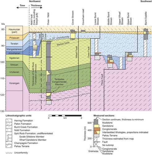
Figure 6. Stratigraphic architecture in the Coverham area, coloured to emphasise age and thickness relationships; lithostratigraphic units are indicated by overprinted patterns. Annotated and more detailed measured sections are given in Figures S4–S6 and, for Burnt Creek Formation, in Crampton and Laird (Citation1997). Note that the Urutawan and Motuan stages cannot be differentiated reliably (see text). In several places total thickness of units could not be logged in the field and, instead, thicknesses are estimated from the geological map (). For the purposes of this figure, it is assumed that the Champagne Formation is Korangan or older. The datum is the base of Haumurian Stage Herring Formation. Note that horizontal distances are indicative only.
Nidd Formation is overlain by Paton Formation and the two units are lithologically similar. Paton Formation is not described herein but is differentiated from Nidd Formation by its comparatively well-bedded nature, the high proportion of relatively well-sorted sandstone, and the relative abundance of glaucony (Reay Citation1993; Crampton and Laird Citation1997). In places the contact between the two units is a significant disconformity that represents some or all of latest Arowhanan–Teratan time (c. 94–86 Ma; e.g. middle Wharekiri section, and ). The contact is clearly erosional in some sections (Laird Citation1992) but, in general, it is unclear the extent to which the disconformity represents non-deposition versus erosion; there is no evidence of an angular discordance between Paton and Nidd formations. Elsewhere the contact is sharp and planar, or difficult to locate precisely, and there is no time missing at the resolution of stages. This is the case in the short section on Coverham road (Figures 6, S6A and S15F), where the base of Paton Formation is placed at the sharp contact between weakly bedded, muddy, very fine sandstone, and overlying decimetre-bedded, glauconitic, well-sorted fine sandstone. Here it is unclear whether the contact represents anything more than a minor break in sedimentation.
Content
The bulk of Nidd Formation comprises rather homogenous, massive to indistinctly decimetre-bedded, pale orange-brown-weathering, medium olive- to greenish-grey (fresh, wet), muddy very fine sandstone to sandy, muddy coarse siltstone; bed boundaries are diffuse (Figures 7F and S15H). It is micaceous and jarositic in places and commonly contains abundant, finely disseminated carbonaceous debris; pyrite is present both finely disseminated and as centimetre-scale nodules. The greenish colour observed through parts of the formation seems to reflect a relatively high content of chloritized, volcanogenic lithic particles and clays rather than glaucony (see the Supplementary Material), although glaucony certainly is present in small amounts at some levels; in places, burrows and the surfaces of macrofossils are lined with an unidentified green clay, probably chlorite. Nidd Formation contains abundant elliptical and spherical concretions that are commonly septarian and up to 2 m in diameter, and laterally continuous concretionary layers up to 1 m thick (visible on F). It also contains common and distinctive tubular concretions that are up to 30 cm in diameter, 1.5 m long, and either orthogonal or parallel to bedding (Figure S15C; cf. Nyman et al. Citation2010; Malie et al. Citation2017); many of these enclose central, c. 1 cm-diameter tubes or conduits that are paired in some cases. Much of the formation appears to be heavily bioturbated to completely mottled, and a rich diversity of ichnotaxa is present (Figure S15E). That said, wavy laminations that are muddy or sandy, remnant flaser bedding, and likely cross-bedding are visible in places (Figure S15C).
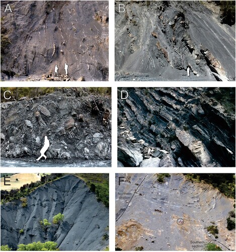
Figure 7. Photographs of representative outcrops of units described here; figure outlines for scale. A, Champagne Formation in Latters stream, Coverham (GR723545), showing sharp (erosive or slumped) contact between moderately deformed mudstone with thin-bedded sandstone (bottom right) and stratigraphically overlying, intensely deformed mudstone (top left). B, Undifferentiated Split Rock Formation in Wharekiri Stream (GR661304; c. 900 m in middle Wharekiri section, Figure S9A), showing c. 10 m-thick syn-sedimentary slump unit; strata young to the right. C, Tentpoles Conglomerate Member of Split Rock Formation, Wharekiri Stream (GR668306; c. 400 m in middle Wharekiri section, Figure S9A); relatively coarse-grained and clast-rich end-member. D, Wharf Sandstone Member of Split Rock Formation, Wharf Stream, Coverham (GR726551); note conspicuously bimodal sandstone bed thickness; strata young to the right. E, Swale Siltstone Member of Split Rock Formation, Cover Stream, Coverham (GR728559), showing relatively homogenous mudstone with scattered, large concretions and thin sandstone beds; sandstone beds close to the top of the outcrop are offset by a small fault, but also pinch out towards the northeast (right, see Figure S14H); exposure c. 50 m high. F, Nidd Formation, type section in Sawpit gully, Coverham (c. GR726566, Figure S2; upper parts of the northern and southern sections of Figure S4); outcrop comprises more-or-less muddy, very fine sandstone to coarse siltstone, with scattered concretions and highly fossiliferous concretionary beds; figures circled for scale.
Fine breccia to coarse sandstone, forming beds up to 50 cm thick, is a minor component of Nidd Formation (see the Supplementary Material). Lower parts of Nidd Formation also include intervals of olive-black mudstone, and beds of pale olive-grey, brown-weathering, well-sorted, fine to very fine sandstone that are laminated, graded and have sharp boundaries (lower part of Figure S4A). These well-sorted sandstone beds may represent thin intercalations of Bluff Sandstone Formation, although only the thickest is explicitly identified as such (1.2 m thick, 11 m on Figure S4A; and see Figure S15B and notes on Bluff Sandstone in the Supplementary Material).
Volcanic rocks occur within Nidd Formation in Swale Stream, Coverham, where isolated bodies of probable pillow basalt are associated with the southeastern strand of the Nidd Fault Zone and enclosed by Arowhanan strata (). These basalts are almost certainly the distal fringe of Gridiron Formation volcanics that crop out extensively in the middle Clarence valley, as noted previously by others (Laird Citation1992; Laird and Bradshaw Citation2020; Gardiner and Hall Citation2021). In Wharf Stream, a second occurrence of basalt bodies is associated with equivocal Nidd Formation; the age and significance of these basalts are discussed in Crampton and Laird (Citation1997).
Paleontology and age
Around Coverham, Nidd Formation is richly macrofossiliferous. Macrofossils are dominated by biostratigraphically useful inoceramid bivalves, although other groups have been recorded (see the Supplementary Material). Within the Nidd Fault Zone, all inoceramid zones of the Raukumara Series are present (zones after Crampton Citation1996; see stage boundaries indicated on ); this is the only place in the South Island were all these zones are preserved. In the Wharekiri area, macrofossils are less abundant, though common in a few beds. Calcareous marine microfossils are little studied and essentially unknown from much of Nidd Formation (but see Wellman Citation1955). In contrast, terrestrial and marine palynofloras provide important age constraints in places, though abundance, richness and quality of preservation are variable. In the Sawpit gully section, rich (almost 80 species) but poorly preserved dinoflagellate floras have been documented in some detail and help to locate the Cenomanian/Turonian boundary within a broad carbon isotope excursion interval, based on correlations to Australia, Europe and North America (Hasegawa et al. Citation2013; Schiøler and Crampton Citation2014). The age of Nidd Formation, determined from these abundant paleontological data, is entirely within the range Arowhanan–Teratan (c. 95–86 Ma). Complex stratigraphic and age relationships within the formation, and between this unit and those above and below, are summarised above.
Environment of deposition
In the Coverham area, the bulk of Nidd Formation comprises fossiliferous, massive to indistinctly bedded, pervasively bioturbated, muddy and only moderately well-sorted, sandstone and coarse siltstone. These features are characteristic of deposition in relatively shallow marine conditions, below fair-weather wave-base, within the offshore transition to proximal offshore setting (e.g. Gowland Citation1996; facies associations 4 and 5 of Schwarz et al. Citation2021; and references therein). Beds of mud-flake breccia or coarse sandstone grits indicate periods of elevated wave or current energy or, perhaps, local, small-scale debris flows. There is little evidence for deposition above wave-base or in the littoral zone (see Supplementary Material), although intercalated, thick beds of well-sorted sandstone, which are here assigned to Bluff Sandstone Formation, may represent short-lived episodes of shoreface deposition.
According to Schwarz et al. (Citation2021), sparse evidence for storm-influence within highly bioturbated, shallow-marine strata does not necessarily indicate low storm frequency or deposition below storm wave-base, but may reflect sustained, efficient and long-lived reworking of the substrate by the benthic fauna. These authors went on to argue that accumulation of substantial thicknesses (i.e. hundreds of metres) of highly bioturbated, storm-influenced, shallow-marine strata may be characteristic of long-term aggradation in relatively confined depocentres with persistently low riverine influence. In the case of Nidd Sandstone Formation, there is evidence in the Coverham area both for accumulation of several hundred metres of this unit within a confined depocentre over a sustained period of almost 10 Myr (herein), and for a setting relatively remote from a fluvial point source (Schiøler and Crampton Citation2014). Away from the Nidd Fault Zone, the depositional situation may be somewhat different: Nidd Formation thins markedly, and it has been regarded as a condensed unit (Laird et al. Citation1994; Laird and Bradshaw Citation2020). As detailed earlier, this thinning reflects a complex interplay of reduced rates of sedimentation, erosion or non-deposition of younger parts of the formation below an unconformity, and non-deposition of older parts of the formation above an unconformity (summarised in ). Further detailed investigation of complex spatial and temporal variations in facies and stratigraphic architecture of Nidd Formation is beyond the scope of the present study.
Cretaceous faulting at Coverham and Wharekiri
The formations described above display dramatic facies and thickness contrasts across a number of faults in the Coverham and Wharekiri areas ( and ), and these contrasts may indicate that faults were active during some part of the Cretaceous. Despite the rich information base, however, interpretation of fault histories is not straight-forward. In particular, it is difficult to separate the effects of post-depositional Neogene shortening from possible effects of Cretaceous syn-depositional faulting. In addition, some faults may well have had some component of strike-slip offset either during the Cretaceous or during Cenozoic reactivation, which may account in part for stratigraphic contrasts, but this cannot be demonstrated with existing data (and see Hall Citation1964). To reflect this uncertainty, apparent dip-slip fault offsets are expressed simply as stratigraphic separations and do not assume any particular displacement vector. Key faults with evidence for Cretaceous activity are discussed below, from north to south; additional notes on these and other faults are given in the Supplementary Material.
Nidd Fault Zone (new name)
The Nidd Fault Zone at Coverham (named herein) comprises at least three northwest-dipping structures that merge along strike at the surface and also likely merge at depth (); some of these structures have been recognised in various configurations by earlier geologists (Hall Citation1963, Citation1964; Ritchie Citation1986; Rattenbury et al. Citation2006). Different component strands are well exposed in places (see Supplementary Material). The Nidd Fault Zone and the Chalk Range Fault merge towards the northeast to form the Brian Boru Fault of Townsend (Citation2001), which comprises part of the Flags Creek Fault System, an imbricated and folded thrust stack that extends around the hinge of the Ben More Anticline (; and see Rattenbury et al. Citation2006).
Large contrasts in the age and thickness of Nidd Formation between exposures within the Nidd Fault Zone and in Cover Stream () have undoubtedly been influenced by Neogene shortening across the fault zone. Amounts of offset across individual faults have not been determined and are hard to estimate given that the faults are subparallel to bedding at the surface. Based on available data, however, it is considered unlikely that shortening across the Nidd Fault Zone will have been sufficient, on its own, to explain stratigraphic contrasts within Nidd Formation (see Supplementary Material).
Instead, it seems that contrasts between strata within the Nidd Fault Zone and those exposed in Cover Stream must reflect the presence of substantial, original depositional architecture over short distances. Several explanations are possible and involve some combination of stratigraphic downlap or onlap, syn-depositional folding or faulting, and localised, syn-depositional uplift and erosion (Figure S17); analogous complexity, in the context of the modern Hikurangi subduction wedge, is described by McArthur et al. (Citation2020). Although it is not possible to say for sure which of these explanations is correct, three lines of evidence are salient. First, localised uplift and erosion during the latest Mangaotanean–Teratan (c. 91–86 Ma) are demonstrated by the presence of large clasts (>1 m) containing Arowhanan and Mangaotanean fossils that have been reworked into Teratan conglomerate of nearby Burnt Creek Formation (P30/f566, f571, f2462). Secondly, localised uplift and erosion must have terminated within the Teratan, since strata of this age apparently mantle the Nidd Fault Zone (). Lastly, evidence for Mangaotanean–Teratan activity on Pikes Fault ( and see below) provides circumstantial support for a model of coeval fault activity on the proto-Nidd Fault. These and other lines of evidence are discussed in more detail in the Supplementary Material.
Based on arguments given above, therefore, the most parsimonious explanation of stratigraphic contrasts within and adjacent to the Nidd Fault Zone requires that a precursor fault within this zone was active for a short interval during latest Mangaotanean to earliest Teratan time (c. 91–89 Ma). This precursor fault was likely to have had a normal sense of stratigraphic separation, although this cannot be demonstrated. Uplift resulted in local erosion of Arowhanan and Mangaotanean strata in a narrow strip that was bounded to the northwest by this proto-Nidd Fault and, to the southeast, by the Ouse Fault (see below and ).
Ouse Fault
Ouse Fault at Coverham was named by Ritchie (Citation1986). On his geological map, he misplaced the fault a few hundred metres to the west of its true position in Ouse Stream, thereby including parts of Champagne Formation within Burnt Creek Formation. Note also that Rattenbury et al. (Citation2006) confused Ouse Fault of earlier workers with Wharf Fault (named herein; ). The original concept of the Ouse Fault is retained here for the major structure that separates Champagne and Split Rock formations from Burnt Creek Formation (; and see Crampton and Laird Citation1997). This structure is, in part, the same as the ‘Wharfe fault’ of Hall (Citation1964).
Ouse Fault clearly has a complex history of activity, based on cross-cutting relationships and disparate ages of strata on either side of the fault. Although it is well exposed in many places, detailed structural investigation is beyond the scope of the present paper (but see details in the Supplementary Material). Available data suggest that the fault dips northwest somewhat more steeply than bedding in the foot-wall; assuming that the fault was active during the Cretaceous (see below), then restoration to bedding-horizontal indicates that it was approximately north-dipping at between 10° and 40° during deposition of Champagne, Split Rock, Nidd and Burnt Creek formations.
Champagne and Split Rock formations are restricted to the northwestern, hanging-wall side of the Ouse Fault, where they have a combined minimum thickness of c. 1400 m (Figures 6 and S5). The oldest cover strata that occur on both sides of the fault are Teratan (c. 90–86 Ma) and, in contrast to underlying units, these are thickest on the foot-wall: Teratan Nidd Formation is c. 120 m thick on the hanging-wall and Teratan Burnt Creek Formation is c. 400 m thick on the foot-wall. Taken at face value, these age-thickness relationships suggest that the fault is likely to have been active during some part of the late Korangan to Teratan interval (c. 113–86 Ma), and that the sense of dip-slip separation reversed at about the Mangaotanean/Teratan boundary (c. 90 Ma). Stratigraphic patterns in overlying, Piripauan Paton Formation (c. 86–84 Ma) are apparently little affected by the fault, and Cretaceous activity on this structure seemingly ceased by the end of the Teratan (c. 86 Ma), although the fault clearly has been reactivated during the Cenozoic (not discussed further here).
This simplistic interpretation ignores several assumptions and uncertainties. Most importantly, it is not known whether Champagne and Split Rock formations were deposited on both sides of the fault and subsequently uplifted and eroded on the foot-wall, or whether they were only ever deposited on the hanging-wall. One possibility is that these two formations were deposited on both sides of the fault but, towards the southeast, they pinch out beneath the angular unconformity at the base of overlying Nidd Formation () and Neogene thrusting on the Ouse Fault has juxtaposed formerly separated and contrasting successions. This scenario is considered unlikely, however, given the magnitude of shortening on the Ouse Fault that is required to eliminate 1400 m of strata beneath the c. 10° unconformity (see Supplementary Material). A second possibility is that Champagne and Split Rock formations were deposited on both sides of the fault but eroded and removed in the southeast following Cretaceous uplift of the foot-wall. Thirdly, both units may have been deposited only to the northwest of the fault within an active, fault-angle depocentre. This interpretation of syn-tectonic sedimentation is supported by the presence of pervasive and large-scale soft-sediment deformation and evidence of mass wasting in Champagne Formation and lower parts of Split Rock Formation, the apparently restricted geographic extent of the former, and evidence for active faulting in the Wharekiri area during deposition of Split Rock Formation.
As for Split Rock Formation, it is not possible to know for certain whether Arowhanan (c. 95–94 Ma) strata were deposited on the foot-wall southeast of the Ouse Fault. If they were, and given that Mangaotanean Burnt Creek Formation (c. 94–90 Ma) lies unconformably on Pahau Terrane strata on this side of the fault (), then there would have been perhaps 2.5 Myr or less to accumulate, uplift and erode any Arowhanan deposits. Alternatively, it is equally plausible that Arowhanan strata were never deposited on the foot-wall and, instead, the fault marks the boundary between discrete depocentres with distinct Arowhanan histories.
Based on data summarised above, a parsimonious interpretation suggests that the Ouse Fault was active with a normal sense of stratigraphic separation from at least the Ngaterian, and possibly earlier, until the late Mangaotanean (c. 99–91 Ma; ). During the latest Mangaotanean or earliest Teratan (c. 91–89 Ma), the sense of stratigraphic separation reversed and uplift occurred on the hanging wall, in a narrow strip bounded further to the northwest by the proto-Nidd Fault (see above). This uplift was short-lived, and Cretaceous activity on the fault ceased by about the end of the Teratan (c. 86 Ma). The history proposed here must be regarded as provisional, many uncertainties remain, and detailed structural mapping is required to constrain the Cretaceous and Neogene kinematic history of Ouse Fault.
Pikes Fault
Pikes Fault at Coverham was also named by Ritchie (Citation1986), who inferred that it was active as a listric normal fault during part of the mid-Cretaceous (note that this structure is not the same as the unpublished ‘Pikes fault’ of Hall Citation1964). Although its position is well constrained in Burnt Stream catchment (), Pikes Fault has only been observed at one locality (GR760556), where it is approximately vertical. Once restored to bedding-horizontal, this structure was apparently west-northwest-dipping at c. 45°, although variation in bedding attitudes makes this difficult to determine precisely. Changes in thickness and age of Burnt Creek Formation on either side of Pikes Fault were documented by Crampton and Laird (Citation1997) and are emended herein ( and ). Mangaotanean strata (c. 94–90 Ma) thicken from a few metres in the lower reaches of Burnt Stream to at least 170 m in the middle reaches of the stream and perhaps as much as c. 300 m in upper Wharf Stream south of Whernside (thickness estimated from the map). These strata are truncated against the Pikes Fault and are absent to the southeast, where Teratan Burnt Creek Formation (c. 90–86 Ma) unconformably overlies Pahau Terrane basement. Crampton and Laird (Citation1997) suggested that this distribution of Mangaotanean strata might reflect either syn-depositional faulting, or relative sea-level changes in an area of considerable topographic relief. Given the large magnitude of relief implied, the thickening of Mangaotanean strata towards the Pikes Fault, and the sedimentary facies present in lower parts of Burnt Creek Formation (Crampton and Laird Citation1997), it seems likely that the fault was active during the Mangaotanean and earliest Teratan (c. 94–89 Ma) with a normal sense of stratigraphic separation (). Ritchie (Citation1986) inferred that subsequent reversal of motion on the fault was Cretaceous, although this may in fact reflect a phase of Neogene reactivation. The patterns documented here do not accord well with the inference of Gardiner and Hall (Citation2021) that Burnt Creek Formation was deposited in a trench-slope basin and compressional setting on an active Late Cretaceous accretionary prism.
Wharekiri Fault (new)
Wharekiri Fault is recognised for the first time and named herein (). It is depicted as a relatively simple feature, but in reality it is a deformation zone comprising many separate structures that have complex interrelationships with each other and inferred syn-deformational strata. Several component faults are exposed around GR672315 and GR667305. The measured attitudes of these structures vary from being almost bedding-parallel in the northeast to bedding-oblique in the southwest. Motuan and older parts of Split Rock Formation that are c. 200 m thick to the south and east, thicken abruptly to c. 950 m immediately northwest of the Wharekiri Fault (). Considering these stratigraphic contrasts, and when rotated to bedding-horizontal using an average strike of beds of 010 and a dip of 60° west, the fault zone appears to have been an approximately east-west-striking, listric structure during the Urutawan–Motuan (c. 108–99 Ma) with normal sense of stratigraphic separation and maximum dip to the north of c. 30° (). Up-section, the fault apparently terminates within Swale Siltstone Member of Split Rock Formation, and probably ceased activity during the Ngaterian (c. 99–95 Ma). To the north and east, it merges with the Limestone Stream and Puhipuhi faults (new names), both of which represent Cenozoic structures.
Figure 8. Stratigraphic architecture in the Wharekiri area, coloured to emphasise age and thickness relationships; lithostratigraphic units are indicated by overprinted patterns. Annotated and more detailed measured sections are given in Figures S7–S10. Relatively sparse paleontological data mean that that placement of the Motuan/Ngaterian boundary is approximate only and the Urutawan and Motuan stages cannot be differentiated (see text). In the south, the datum is the base of Haumurian Stage Herring Formation; in the north, sections are levelled on the top Tentpoles Conglomerate Member. Note that horizontal distances are indicative only.
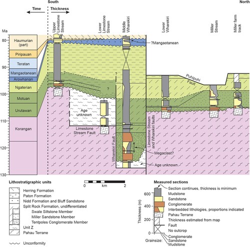
Mid-Cretaceous geological history of northeastern Clarence valley
Based on synthesis of data discussed above, the following geological history is inferred for the area around what is now the northeastern end of the Clarence valley ( and ). Note that age ranges bracket possible age limits and do not imply continuous activity over the given intervals.
Korangan or older (pre-c. 113 Ma): Pahau Terrane strata were incorporated into the accretionary prism during the latest stage of Mesozoic subduction on the Zealandian margin of Gondwana. Subsequent deformation and associated base-level fall resulted in subaerial erosion of these strata, at least locally.
Late Korangan (c.?113–108 Ma): Base-level rise created accommodation space and resulted in deposition locally of Champagne Formation in a marine environment. During the latest Korangan to Urutawan ages (c. 110–103 Ma), substantial parts of Champagne Formation were remobilized into a mass-transport complex and redeposited at bathyal or greater water depths (A), perhaps into an active, fault-controlled basin on the hanging wall of the Ouse Fault.
Latest Urutawan to late Ngaterian (c. 105–97 Ma): Split Rock Formation was deposited unconformably on Pahau Terrane, Unit Z, and Champagne Formation strata during continued base-level rise. Initially, mass-transport deposits, slumps and sediment gravity flows accumulated rapidly at a range of water depths within canyons incised into Pahau Terrane, and within confined depocentres on the hanging-walls of syn-depositional faults that had normal senses of stratigraphic separation, including the Wharekiri and possibly Ouse faults (A). Subsequently, Ngaterian strata record sedimentation at mid-shelf or greater water depths, decreasing depositional energy, declining fault activity at Wharekiri, and partial burial of topographic relief (Figures 9B and 10B).
Late Ngaterian to earliest Arowhanan (c. 97–95 Ma): A region-wide base-level fall was coincident with short-lived uplift and open folding, presumed subaerial erosion of Split Rock Formation, and development of a diachronous angular unconformity (Figures 2, 9C and 10C). Uplift was coincident with intrusion of the Tapuaenuku Igneous Complex and associated eruption of voluminous subaerial and shallow-marine basalts in the Clarence and Awatere valleys (Gridiron and Lookout formations; Reay Citation1993; Rattenbury et al. Citation2006; and references therein). (Note that the Tapuaenuku Igneous Complex is centred on the mountain that is now written more correctly as ‘Tapuae-o-Uenuku’; see .)
Late Ngaterian to late Arowhanan (c. 97–94.5 Ma): Resumption of base-level rise was partly coincident with uplift noted above, such that strata above the unconformity in the middle Clarence valley overlap in age with strata lying beneath the unconformity in the north and east (). In the southwest, strata overlying the unconformity are non-marine (Warder Formation and subaerial basalt flows of Gridiron Formation), but in most places these strata were deposited in comparatively shallow-marine shoreface to mid-shelf environments (Bluff Sandstone and Nidd formations). Ouse Fault was active with a normal sense of stratigraphic separation. Stratigraphic patterns suggest the presence of a complex, strongly embayed coastline at this time.
Late Arowhanan to Mangaotanean (c. 94.5–90.5 Ma): Base-level rise and accumulation of Nidd Formation continued at inner to mid-shelf depths in some areas at least (Figures 9D, 10D). Activity on the Ouse Fault persisted with a normal sense of stratigraphic separation until late in the Mangaotanean. At the same time, Pikes Fault was active for the latter part of the Mangaotanean with normal sense of stratigraphic separation, and submarine, basal mass-flow deposits of Burnt Creek Formation accumulated within a small, asymmetric depocenter on the northwestern hanging-wall (E).
Early Teratan (c. 90.5–89 Ma): At about the Mangaotanean/Teratan boundary there was reversal of apparent motion on the Ouse Fault, gentle tilting and local ?subaerial erosion along a narrow strip on the hanging-wall. This strip was bounded further to the northwest by the proto-Nidd Fault (Figures 9E and S17E). Deposition continued on either side of the uplifted strip, with accumulation of Nidd Formation to the northwest and Burnt Creek Formation to the southeast. Elsewhere in the Clarence valley and at Wharekiri, Teratan strata are missing (, and see below).
Mid- to late Teratan (c. 89–86.5 Ma): Activity on the Ouse Fault continued with a reverse sense of stratigraphic separation, but base-level rise outstripped uplift and Teratan strata accumulated across both the hanging- and foot-walls (F). Nidd Formation was deposited at inner to mid-shelf depths on the hanging-wall, whereas a greater thickness of Burnt Creek Formation accumulated on the foot-wall in somewhat deeper waters (Crampton and Laird Citation1997). In contrast, at Wharekiri and in the middle Clarence valley, this interval is represented by a significant disconformity () that might reflect non-deposition, or deposition and subsequent erosion. Erosion due to uplift, if any, was not associated with significant deformation, and it is unclear whether eustatic sea-level changes would have been sufficient to generate the disconformity (cf. Haq Citation2014; Ray et al. Citation2019). The most parsimonious explanation would invoke region-wide base-level rise, as seen at Coverham, and widespread deposition throughout the Mangaotanean and Teratan (E) followed, in the latest Teratan or earliest Piripauan (c. 86 Ma), by long wavelength but short-lived uplift and erosion of these strata in many in areas south of Coverham (F).
Piripauan to earliest Haumurian (c. 86.5–82 Ma): Base-level rise coincided with deposition of Paton Formation across the entire region (Figures 2, 9G and 10G). This unit was deposited at a range of shelf water depths, possibly in a prodeltaic environment, with marginal marine settings in the southwest and increasing water depths towards the northeast and, in general, over time (Reay Citation1993; Crampton and Laird Citation1997; Schiøler et al. Citation2002; Crampton et al. Citation2003; Laird and Bradshaw Citation2020). By this time, on-going tectonic activity, if any, was relatively minor (but see Crampton et al. Citation2003).
Early to mid-Haumurian (82–c. 72 Ma): Relatively uniform depositional conditions developed throughout much of the East Coast Basin during continued base-level rise and transgression. In the Coverham and Wharekiri areas, Herring Formation accumulated above a minor disconformity at mid- to outer shelf or upper bathyal water depths (Schiøler et al. Citation2002; Crampton et al. Citation2003; and see additional comments on this unit in the Supplementary Material).
Figure 9. Cartoon to illustrate the inferred Cretaceous geological history recorded at Coverham. Stratigraphy is coloured by formation and colours match and . These reconstructions take no account of likely Cenozoic shortening across some of these faults. Relative thicknesses of formations and relative water depths are indicative only. In panels A and B, thickening of units towards the Ouse Fault is speculative. In panels B and C, deposition of Split Rock Formation to the southeast of Ouse Fault and subsequent uplift and erosion of these strata is based on evidence from the Wharekiri and Kekerengu areas. In panels D and E, age relationships within Nidd and Burnt Creek formations are indicated using stage symbols (Ra = Arowhanan, Rm = Mangaotanean, Rt = Teratan).
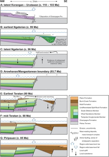
Figure 10. Cartoon to illustrate the inferred Cretaceous geological history recorded at Wharekiri. Stratigraphy is coloured by formation and colours match and , except that Pahau Terrane and Unit Z are not discriminated here. Relative thicknesses of formations and relative water depths are indicative only.
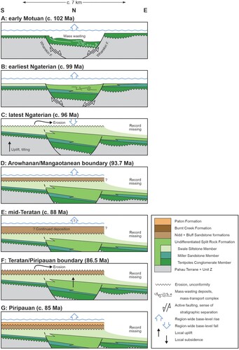
Discussion
Significance of mid-Cretaceous faulting in the northeastern Clarence valley
Observations from across Zealandia have demonstrated widespread normal faulting from c. 105 Ma, which has been inferred to mark crustal stretching following subduction shut-down on the Zealandian margin (e.g. Strogen et al. Citation2017; Tulloch et al. Citation2019; Barrier et al. Citation2020; Sahoo et al. Citation2020; and many references therein). In contrast and based on Cretaceous strata from the Clarence and Awatere valleys, other authors have inferred that subduction and associated thrusting on this margin persisted until as late as 86 Ma (Gardiner and Hall Citation2021); similar inferences have been made for correlative units in the northern part of the East Coast Basin (Mazengarb and Harris Citation1994).
Results presented here suggest that three or four faults in the northeastern Clarence valley area were north- to west-dipping structures that were active within the Urutawan to Teratan interval (c. 108–86 Ma): the Ouse, Pikes, Wharekiri and ?proto-Nidd faults. These seem to have been low-angle structures during the Cretaceous, with original dips of between c. 10° and 45°, and the Wharekiri Fault apparently was a listric fault. Whereas significant uncertainties remain, the component of dip-slip on all these faults seems have been dominantly normal during the mid-Cretaceous, with basement uplifted to the south and east (Figures 6 and 8–10), although the sense of offset reversed across the Ouse Fault for a brief interval during the Teratan (c. 90–86 Ma; summarised on ). A similar, low-angle normal fault was identified nearby in the Awatere valley by Kundycki (Citation1996), who inferred large northeast-southwest-directed extension along the ‘Winterton fault’ (informal name) during the mid-Cretaceous.
Figure 11. Summary of Cretaceous tectonic and stratigraphic signals observed at the northeastern end of the Clarence valley, and comparison with selected regional tectonic, stratigraphic, metamorphic and magmatic events from across Zealandia, compiled from the literature. BCF = Burnt Creek Formation, CF = Champagne Formation, GF = Gridiron Formation, HF = Herring Formation, NF = Nidd Formation, PF = Paton Formation, PT = Pahau Terrane, SRF = Split Rock Formation, TIC = Tapuaenuku Igneous Complex. References: 1, Schwartz et al. (Citation2016); 2, Klepeis et al. (Citation2007); 3, Crampton et al. (Citation2019), and see text; 4, Davy (Citation2014), Reyners et al. (Citation2017), Mortimer et al. (Citation2019); 5, Schwartz et al. (Citation2017); 6, Strogen et al. (Citation2017), Raine et al. (Citation2018), Barrier et al. (Citation2020); 7, Tulloch et al. (Citation2009), Hoernle et al. (Citation2020); 8, Strogen et al. (Citation2017), Raine et al. (Citation2018); 9, Vry et al. (Citation2004), but see Briggs et al. (Citation2018); 10, Laird and Bradshaw (Citation2020), and references therein; 11, Strogen et al. (Citation2017).
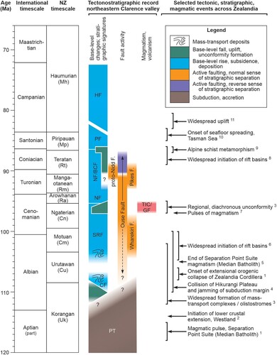
The presence of putative normal faulting is, in itself, not diagnostic of tectonic setting. Hence, for example, substantial normal faults can form within the forearc and wedge of an active subduction zone in response to flattening of the down-going slab (e.g. Noury et al. 2017; van de Lagemaat et al. Citation2023) or the presence of high-relief on the subducting plate (e.g. Barnes et al. Citation2002), and normal offsets can develop at releasing bends in a zone of strike-slip deformation. In addition, the apparently low dip-angles during the Cretaceous of faults described from the Clarence and Awatere valleys are atypical of most normal faults formed in rift settings, although low angles can reflect either rotation of originally high-angle faults, or reactivation of low-angle thrust faults (Morley Citation2014; Deng et al. Citation2022; and references therein). Notwithstanding these caveats, the inference of normal faults within the Clarence valley area during the Urutawan to Teratan is entirely consistent with the large body of evidence for extensional faulting of this age from across much of Zealandia, noted above. The most parsimonious interpretation would suggest deposition and faulting of Split Rock, Nidd and Burnt Creek formations in an extensional tectonic regime following subduction shut-down at about 105 Ma, with cessation of normal fault activity by about mid-Teratan time (c. 89 Ma). The significance of brief reversal of offset on the Ouse Fault during the Teratan remains unclear.
The ‘basement/cover’ unconformity
A significant, diachronous, angular unconformity between Pahau Terrane ‘basement’ rocks and Clarence Series ‘cover’ strata has been observed, inferred, or assumed in Marlborough-north Canterbury and, indeed, throughout much of the East Coast Basin (e.g. Field et al. Citation1997; Bland et al. Citation2015; Crampton et al. Citation2019; Laird and Bradshaw Citation2020). In contrast, Gardiner and colleagues argued recently that ‘Postulated “basement-cover” angular unconformities within Urutawan–Motuan units [in inland and eastern Marlborough-north Canterbury] … are contained within marine successions and can be attributed to localised (i.e. non sequence-bounding) processes, typically submarine canyon or channel incision’ (Gardiner and Hall Citation2021, p. 23). They went on to infer conformable contacts between Pahau Terrane and Split Rock Formation at many localities, including the middle Wharekiri, Miller Stream and, questionably, the Ouse-Nidd sections described here. Thus, they concluded that ‘Relationships between Pahau Terrane and cover units in most locations clearly demonstrate stratigraphic continuity from the Korangan into the Urutawan’ (Gardiner et al. Citation2022, p. 18; and see Gardiner et al. Citation2021, supporting information; and earlier discussion in Wellman Citation1959).
This interpretation of essentially conformable deposition from Pahau Terrane into Split Rock Formation does not accord with observations from the Coverham, Wharekiri and Kekerengu areas, detailed above. In particular, the extent and ubiquity of observed angular discordance between these units, the presence of thick conglomerate beds above the contact, differences in the degree of induration and jointing, and available age data (but see below), all indicate the presence of a significant unconformity. That said, the presence of canyon incision is not disputed and is documented in the lower Wharekiri section (Figure S8) and, possibly, between the Kekerengu and Good creek sections (Figure S10).
Pahau Terrane, therefore, is inferred to have been deformed, uplifted and eroded at some point during late Korangan or early Urutawan time (c. 113–105 Ma), prior to deposition of Split Rock Formation. Consensus suggests that deformation and uplift likely followed initial collision of the buoyant Hikurangi Plateau large igneous province into the subduction zone at about 110 Ma or shortly after (e.g. Davy Citation2014; Bland et al. Citation2015; Reyners et al. Citation2017; Crampton et al. Citation2019; Riefstahl et al. Citation2020a; Gardiner et al. Citation2021; but see a very different interpretation of the timing of plateau collision in van de Lagemaat et al. Citation2023). This initial collision apparently involved a narrow, finger-like extension of the plateau, the ‘salient’ of Reyners et al. (Citation2017), which may have impacted the margin in the region of what is now Marlborough (e.g. Riefstahl et al. Citation2020b).
Interpretation is more difficult in places where Champagne Formation or other units of intermediate appearance and ambiguous affinity occupy a stratigraphic position between undoubted Pahau Terrane and Split Rock Formation (i.e. the Ouse-Nidd and middle Wharekiri sections, Figures S5 and S9A). Champagne Formation is bounded by unconformities below and above and may be interpreted as youngest parts of underlying Pahau Terrane that were substantially remobilised and redeposited as a mass-transport complex prior to full lithification and prior to deposition of Split Rock Formation. In reality, whether Champagne Formation should be considered ‘basement’ or ‘cover’ is probably moot; as shown in , it is a depositional remnant preserved within the time span of an unconformity and it records local conditions during a tectonostratigraphic transition. Here, it is included as part of the Momotu Supergroup of Mortimer et al. (Citation2014) (i.e. cover). Likewise, interpretation of Unit Z in the Wharekiri area is uncertain. In general appearance and degree of deformation and lithification, Unit Z resembles sandstone-rich members of Split Rock Formation. In the middle Wharekiri section it underlies Split Rock Formation with at least locally strong angular unconformity. Unit Z may represent a comparatively young and little deformed package of Pahau Terrane strata, a local correlative of Champagne Formation, or an as-yet unnamed unit of the basal cover succession.
Importantly, biostratigraphic resolution in these Korangan to Motuan units (c. 117–99 Ma) – spanning an interval of 18 Myr – has probably been over-estimated in some previous studies and discrimination on the basis of fossil content remains somewhat problematic (see comments in Cooper et al. Citation2004; Crampton Citation2004; Crampton, Tulloch, et al. Citation2004). For this reason and even where fossils are present, it is not currently possible to date accurately the span of the depositional break between putative basement and cover units. Likewise, it is not possible to achieve detailed correlation of structurally complex Pahau Terrane strata across the Marlborough-north Canterbury region (cf. Gardiner and Hall Citation2021; Gardiner et al. Citation2021; and note that a number of paleontological ages are mis-cited in those papers). These general problems reflect the paucity of well-preserved macrofossils within Pahau Terrane and incomplete taxonomic understanding of biostratigraphically useful fossils (e.g. Crampton Citation2004); dinoflagellates, in particular, offer promise for improved biostratigraphic resolution in Korangan–Motuan strata.
The latest Ngaterian unconformity
In the Clarence valley area, the short-lived and diachronous, latest Ngaterian (c. 97–95 Ma) unconformity-forming event has been recognised since the work of McKay (Citation1890) who noted that there must have been ‘an upheaval of the land towards the close of the deposition of the Amuri series [i.e. approximately equivalent to the Coverham Group]’ (p. 146). It is now clear that this latest Ngaterian event is expressed throughout the East Coast Basin and across many parts of Zealandia, and is the same as the 95 Ma event of Crampton et al. (Citation2019), the c. 97 Ma tectono-magmatic event of Laird and Bradshaw (Citation2020, p. 236), and the Ngaterian sequence boundary forming event of Gardiner and Hall (Citation2021). This uplift event was coincident with pulses of felsic and alkaline mafic magmatism across Zealandia (; Tulloch et al. Citation2009; Hoernle et al. Citation2020). Note that a distinct and slightly younger unconformity that was inferred at the base of Nidd Formation by Laird and Bradshaw (Citation2020, see p. 80, their Hapuku Group) in fact represents the youngest expression of the diachronous, latest Ngaterian unconformity-forming event discussed here.
Base-level fall that resulted in the unconformity was substantially tectonic in origin: evidence includes both gentle tilting and/or faulting, and significant compaction (Smale and Laird Citation1995), of Split Rock Formation prior to deposition of younger strata. It is also possible, however, that the effects of uplift were exacerbated by >75 m of eustatic sea-level fall at 95.5 Ma (event KCe4 of Haq Citation2014; note that Ray et al. Citation2019 considered this magnitude of sea-level fall to be unrealistic).
As proposed by others, latest Ngaterian uplift can be explained plausibly by rebound of the subducted plate following cessation of subduction on the margin and slab detachment (e.g. Riefstahl et al. Citation2020a; Gardiner et al. Citation2021). Approximately coincident magmatism has been interpreted to reflect formation of a slab tear along the western margin of the Hikurangi Plateau, which allowed mantle plume material to upwell beneath the accretionary prism (e.g. Hoernle et al. Citation2020). The geographic extent of uplift and, in particular, its expression in northern parts of the East Coast Basin (Crampton et al. Citation2019), suggests a regional tectonic signal that affected much of the Zealandian margin. Importantly, this regional expression is not consistent with a model of margin partitioning, with a boundary at about the location of modern-day Marlborough, such that subduction shut down to the east along the Chatham Rise segment following Hikurangi Plateau collision, but continued to the west for many millions of years, (e.g. maps in Riefstahl et al. Citation2020b; Barrier et al. Citation2021; Gardiner et al. Citation2021). Instead, it seems more reasonable to suggest that the down-going slab stopped subducting along much of the Zealandian margin and then rebounded as a whole, even though there may have been a slab tear formed along the western edge of the Hikurangi Plateau.
The break-up unconformity
Throughout the East Coast Basin, Piripauan strata (c. 86–84 Ma), including Paton Formation, mark the base of the transgressive part – the Haerenga Supergroup – of the first-order Zealandia Megasequence (; e.g. King et al. Citation1999; Crampton et al. Citation2006; Mortimer et al. Citation2014; Laird and Bradshaw Citation2020). Seafloor spreading in the Tasman Sea, to the west of Zealandia, initiated at this time, c. 85–83 Ma (Laird and Bradshaw Citation2020; Strogen et al. Citation2022; and references therein). Different interpretations suggest that an associated break-up unconformity is represented by stratigraphic discontinuities at either the base (Laird and Bradshaw Citation2020) or top (Crampton et al. Citation2019) of Paton Formation and correlatives in the East Coast Basin (correlatives include Owhena, Tahora, and Tangaruhe formations; see Field et al. Citation1997; Crampton et al. Citation2006). In reality, the concept of a break-up ‘unconformity’ as a discrete surface is over-simplified and, instead, it is best thought of as a transition that may contain multiple and diachronous unconformities (e.g. Soares et al. Citation2012; Reeve et al. Citation2022). Thus, in the East Coast Basin, disconformities on either side of Paton Formation and correlatives may, together, form part of the break-up transition. Given the location of the East Coast Basin on the east-facing, paleo-Pacific margin of Zealandia, then any putative break-up transition in the successions studied here that resulted from seafloor spreading in the Tasman Sea must reflect far-field effects that were expressed across much of Zealandia.
Conclusions
New geological maps are given for three areas at the northeastern end of the Waiau Toa/Clarence valley, northeastern South Island, New Zealand. These maps encompass Coverham, a small area of the Kekerengu River valley, and the Wharekiri Stream valley and environs. The maps, in combination with measured sections and abundant biostratigraphic data, help to resolve complex and hitherto poorly understood stratigraphic and structural relationships within and between mid-Cretaceous formations. Key findings are summarised below.
The somewhat enigmatic Champagne Formation at Coverham likely represents a geographically restricted, submarine mass-transport complex, derived from the youngest strata of Pahau Terrane, that was redeposited in the latest Korangan or Urutawan (between c. 110 and 103 Ma).
Split Rock Formation is the southern component of a geographically widespread depositional tract that extends throughout the western half of the East Coast Basin. It is inferred to represent the earliest phase of post-subduction sedimentation on the Zealandian margin. It records latest Urutawan and Motuan (c. 105–99 Ma) submarine deposition initially by mass-transport processes, slumps, and gravity flows within confined depocentres formed by canyons and faulted basins, with steep seafloor gradients and rapid sedimentation. Younger parts of the formation record progressive burial of seafloor topography and shallowing during the Ngaterian (c. 99–95 Ma).
Nidd Formation was deposited at shelf depths during the Arowhanan–Teratan (c. 95–86 Ma), following latest Ngaterian regional uplift (c. 97–95 Ma), local subaerial erosion, and formation of a strongly embayed paleocoastline. As noted by others, latest Ngaterian regional uplift is expressed across much of Zealandia and may have resulted from rebound of the subducted plate following the end of subduction and slab detachment.
All three formations described above apparently record syn-tectonic deposition in small basins bounded by the proto-Nidd, Ouse, Pikes, and Wharekiri faults. These faults display dominantly normal stratigraphic separations and, although uncertainties remain, they seem to have had substantial components of normal displacement at different times between the Urutawan and Teratan (c.?108–89 Ma). The Ouse Fault experienced a brief episode of reversal in offset during the Teratan (c. 90–86 Ma).
Acknowledgements
Field work for this study was undertaken over a period of three decades, between 1989 and 2020. I wish to acknowledge the field assistance of many people: Cliff Atkins, Troy Collier, James Dwight, Ralph Elasser, Hima Hassenruck-Gudipati, Ben Hines, Malcolm Laird, James Landon, Felicity Maxwell, Shela Nightingale, and Henning Peters. For field data in the Wharekiri area, I thank Russ Van Dissen, and for advice and discussions, Kyle Bland, Tim Little, Dominic Strogen and Andy Tulloch. For access permissions and hospitality, I am particularly grateful to the landowners: the Murrays at Bluff Station and their shepherds stationed at Coverham, the Kings at Middle Hill Station, Nicky McArthur at Puhi Peaks Station, the Greens at Remuera Station, and the Rowlands at Matiawa Station. This study has made extensive use of paleontological data housed in the New Zealand Fossil Record File (https://fred.org.nz/), and I acknowledge generations of contributors to this resource. Lastly, I am grateful for constructive and careful reviews by Kyle Bland, Dougal Townsend, and the editor, Richard Jongens, which substantially improved the final paper.
Disclosure statement
No potential conflict of interest was reported by the author(s).
Data availability statement
A file containing supplementary data, descriptions, figures and reasoning in support of this paper is available in figshare via https://doi.org/10.6084/m9.figshare.22290778. All paleontological data used in the study are lodged in the New Zealand Fossil Record File (Clowes et al. Citation2020), accessible at https://fred.org.nz/.
Correction Statement
This article was originally published with errors, which have now been corrected in the online version. Please see Correction (https://doi.org/10.1080/00288306.2023.2282797)
References
- Adams CJ, Mortimer N, Campbell HJ, Griffin WL. 2013. The mid-Cretaceous transition from basement to cover within sedimentary rocks in eastern New Zealand: evidence from detrital zircon age patterns. Geological Magazine. 150:455–478.
- Allmendinger RW, Cardozo N, Fisher DM. 2011. Structural geology algorithms: vectors and tensors. Cambridge, UK: Cambridge University Press.
- Barnes PM, Nicol A, Harrison T. 2002. Late Cenozoic evolution and earthquake potential of an active listric thrust complex above the Hikurangi subduction zone, New Zealand. GSA Bulletin. 114(11):1379–1405.
- Barrier A, Browne GH, Nicol A, Bassett K. 2021. Sedimentary architecture of a Late Cretaceous under-filled rift basin, Canterbury Basin, New Zealand. Basin Research. doi:10.1111/bre.12622.
- Barrier A, Nicol A, Browne GH, Bassett KN. 2020. Late Cretaceous coeval multi-directional extension in South Zealandia: implications for eastern Gondwana breakup. Marine and Petroleum Geology. 118:104383.
- Bengtson P, Kakabadze MV. 2018. Ammonites and the mid-Cretaceous saga. Cretaceous Research. 88:90–99.
- Bland KJ, Uruski CI, Isaac MJ. 2015. Pegasus Basin, eastern New Zealand: a stratigraphic record of subsidence and subduction, ancient and modern. New Zealand Journal of Geology and Geophysics. 58(4):319–343.
- Bouma AH. 1962. Sedimentology of some Flysch deposits: a graphic approach to facies interpretation. Amsterdam: Elsevier.
- Briggs SI, Cottle JM, Smit MA. 2018. Record of plate boundary metamorphism during Gondwana breakup from Lu–Hf garnet geochronology of the Alpine Schist, New Zealand. Journal of Metamorphic Geology. 36:821–841.
- Cantrill DJ, Raine JI. 2006. Wairarapaia mildenhallii gen. et sp. nov., a new araucarian cone related to Wollemia from the Cretaceous (Albian-Cenomanian) of New Zealand. International Journal of Plant Sciences. 167(6):1259–1269.
- Cardozo N, Allmendinger RW. 2013. Spherical projections with OSXStereonet. Computers & Geosciences. 51:193–205.
- Challis GA. 1966. Cretaceous stratigraphy and structure of the Lookout area, Awatere valley. Transactions of the Royal Society of New Zealand, Geology. 4:119–135.
- Claussmann B, Bailleul J, Chanier F, Mahieux G, Caron V, McArthur AD, Chaptal C, Morgans HEG, Vendeville BC. 2021. Shelf-derived mass-transport deposits: origin and significance in the stratigraphic development of trench-slope basins. New Zealand Journal of Geology and Geophysics. 65:17–52.
- Clowes CD, Crampton JS, Bland KJ, Collins KS, Prebble JG, Raine JI, Strogen DP, Terezow MG, Womack T. 2020. The New Zealand Fossil Record File: a unique database of biological history. New Zealand Journal of Geology and Geophysics. 64:62–71.
- Cooper RA, editor. 2004. The New Zealand geological timescale. Institute of Geological and Nuclear Sciences Monograph. 22:1–284.
- Cotton CA. 1955. Review of the Notocenozoic, or Cretaceso-Tertiary of New Zealand. Transactions of the Royal Society of New Zealand. 82:1071–1022.
- Crampton JS. 1989. An inferred Motuan sedimentary mélange in southern Hawkes Bay. New Zealand Geological Survey Record. 40:3–12.
- Crampton JS. 1996. Inoceramid bivalves from the Late Cretaceous of New Zealand. Institute of Geological and Nuclear Sciences Monograph. 14:i–iv:1–188.
- Crampton JS. 2004. Shell composition, cryptic costae, complex composite molds and taphonomic chicanery in Mytiloides (Inoceramidae, Bivalvia). Journal of Paleontology. 78:1187–1191.
- Crampton JS, Hollis CJ, Raine JI, Roncaglia L, Schiøler P, Strong CP, Wilson GJ. 2004. Cretaceous (Taitai, Clarence, Raukumara and Mata Series). In: Cooper RA, editor. The New Zealand geological timescale, Vol. 22. Lower Hutt: Institute of Geological and Nuclear Sciences Monograph; p. 102–122.
- Crampton JS, Laird M, Nicol A, Townsend D, Van Dissen R. 2003. Palinspastic reconstructions of southeastern Marlborough, New Zealand, for mid-Cretaceous – Eocene times. New Zealand Journal of Geology and Geophysics. 46:153–175.
- Crampton JS, Laird MG. 1997. Burnt Creek Formation and Late Cretaceous basin development in Marlborough, New Zealand. New Zealand Journal of Geology and Geophysics. 40:199–222.
- Crampton JS, Laird MG, Nicol A, Hollis C, van Dissen R. 1998. Field trip 6; geology at the northern end of the Clarence valley, Marlborough: a complete record spanning the Rangitata to Kaikoura orogenies. Geological Society of New Zealand Miscellaneous Publication. 101B:1–35.
- Crampton JS, Mortimer N, Bland KJ, Strogen DP, Sagar M, Hines BR, King PR, Seebeck H. 2019. Cretaceous termination of subduction at the Zealandia margin of Gondwana: the view from the paleo-trench. Gondwana Research. 70:222–242.
- Crampton JS, Mumme T, Raine I, Roncaglia L, Schiøler P, Strong P, Turner G, Wilson G. 2000. Revision of the Piripauan and Haumurian local stages and correlation of the Santonian-Maastrichtian (Late Cretaceous) in New Zealand. New Zealand Journal of Geology and Geophysics. 43:309–333.
- Crampton JS, Schiøler P, Roncaglia L. 2006. Detection of Late Cretaceous eustatic signatures using quantitative biostratigraphy. Geological Society of America Bulletin. 118:975–990.
- Crampton JS, Tulloch AJ, Wilson GJ, Ramezani J, Speden IG. 2004. Definition, age, and correlation of the Clarence Series stages in New Zealand (late Early to early Late Cretaceous). New Zealand Journal of Geology and Geophysics. 47:1–19.
- Davy B. 2014. Rotation and offset of the Gondwana convergent margin in the New Zealand region following Cretaceous jamming of Hikurangi Plateau large igneous province subduction. Tectonics. 33(8):1577–1595.
- Deng H, McClay K, Belgarde C. 2022. Low-angle normal faults on the NW Shelf of Australia: implications for late Paleozoic rifting. Tectonics. 41(6):e2021TC007088. doi:10.1029/2021TC007088.
- Feary DA. 1979. Geology of the Urewera Greywacke in Waioeka Gorge, Raukumara Peninsula, New Zealand. New Zealand Journal of Geology and Geophysics. 22:693–708.
- Field BD, Uruski C, et al. 1997. Cretaceous-Cenozoic geology and petroleum systems of the East Coast region, New Zealand. Institute of Geological and Nuclear Sciences Monograph. 13:1–244 + enclosures.
- Gair HS. 1967. The question of post-Rangitata peneplanation in New Zealand; an investigation of Cretaceous peneplanation in relation to unconformities in Upper Jurassic and Cretaceous sequences [dissertation]. Christchurch: University of Canterbury.
- Gangl SK, Moy CM, Stirling CH, Jenkyns HC, Crampton JS, Clarkson MO, Ohneiser C, Porcelli D. 2019. High-resolution records of Oceanic Anoxic Event 2: insights into the timing, duration and extent of environmental perturbations from the palaeo-South Pacific Ocean. Earth and Planetary Science Letters. 518:172–182.
- Gardiner NP, Hall M. 2021. Discordant forearc deposition and volcanism preceding late-Cretaceous subduction shutdown in Marlborough, north-eastern South Island, New Zealand. Earth Science Reviews. 214:103530.
- Gardiner NP, Hall M, Cawood PA. 2021. A forearc stratigraphic response to Cretaceous Plateau Collision and Slab Detachment, South Island, New Zealand. Tectonics. 40(10):e2021TC006806. doi:10.1029/2021TC006806.
- Gardiner NP, Hall M, Frears BT, Lovell RWW. 2022. A stratigraphic record from syn to post subduction sedimentation in Marlborough, New Zealand, and implications for Gondwana breakup. Marine and Petroleum Geology. 136:105472.
- Gowland S. 1996. Facies characteristics and depositional models of highly bioturbated shallow marine siliciclastic strata: an example from the Fulmar Formation (Late Jurassic), UK central Graben. Geological Society, London, Special Publications. 114(1):185.
- Hall WDM. 1963. The Clarence Series at Coverham, Clarence valley. New Zealand Journal of Geology and Geophysics. 6:28–37.
- Hall WDM. 1964. The geology of Coverham and the upper Waima Valley, Marlborough [master’s thesis]. Wellington: Victoria University of Wellington.
- Haq BU. 2014. Cretaceous eustasy revisited. Global and Planetary Change. 113:44–58.
- Hasegawa T, Crampton JS, Schiøler P, Field B, Fukushi K, Kakizaki Y. 2013. Carbon isotope stratigraphy and depositional oxia through Cenomanian/Turonian boundary sequences (Upper Cretaceous) in New Zealand. Cretaceous Research. 40:61–80.
- Hector J. 1886. Progress report, 1885. New Zealand Geological Survey Reports of Geological Explorations. 17:ix–xl.
- Henderson RA. 1973. Clarence and Raukumara Series (Albian – ?Santonian) Ammonoidea from New Zealand. Journal of the Royal Society of New Zealand. 3:71–123.
- Hines BR, Seebeck H, Crampton JS, Bland KJ, Strogen DP. 2022. Reconstructing a dismembered Neogene basin along the active Hikurangi subduction margin, New Zealand. Geological Society of America Bulletin. doi:10.1130/B36308.1.
- Hoernle K, Timm C, Hauff F, Tappenden V, Werner R, Jolis EM, Mortimer N, Weaver S, Riefstahl F, Gohl K. 2020. Late Cretaceous (99–69 Ma) basaltic intraplate volcanism on and around Zealandia: tracing upper mantle geodynamics from Hikurangi Plateau collision to Gondwana breakup and beyond. Earth and Planetary Science Letters. 529:115864.
- Hollis C, Crampton JS, Morgans H, Reid C. 2013. Geosciences 2013 – fieldtrip 9. Cretaceous-Paleogene stratigraphy of north-eastern South Island. Geoscience Society of New Zealand Miscellaneous Publication. 136B:1–51.
- Hollis C, Strong P, Laird M, Crampton JS. 2005. Field trip 1; Cretaceous-Paleogene stratigraphy of eastern Marlborough: opening a South Pacific window on a greenhouse Earth. Field trip guides, 50th Kaikoura; 50th Anniversary Conference. Geological Society of New Zealand Miscellaneous Publication. 119B:1–35.
- Johnston MR. 1980. Geology of the Tinui-Awatoitoi District. New Zealand Geological Survey Bulletin. 94:1–62.
- King P R, Naish T R, Browne G H, Field B D, Edbrooke S W. 1999. Cretaceous to Recent sedimentary patterns in New Zealand. Institute of Geological and Nuclear Sciences Folio Series. 1:1–35.
- King PR, Naish TR, Browne GH, Field BD, Edbrooke SW. 1999. Cretaceous to Recent sedimentary patterns in New Zealand. Institute of Geological and Nuclear Sciences Folio Series. 1:1–35.
- Klepeis KA, King D, De Paoli M, Clarke GL, Gehrels G. 2007. Interaction of strong lower and weak middle crust during lithospheric extension in western New Zealand. Tectonics. 26:1–27.
- Kundycki EA. 1996. Awatere dyke swarm, Marlborough, New Zealand [master’s thesis]. Wellington: Victoria University of Wellington.
- Laird MG. 1992. Cretaceous stratigraphy and evolution of the Marlborough segment of the East Coast region. 1991 New Zealand Oil Exploration Conference proceedings. Wellington: Petroleum and Geothermal Unit, Energy and Resources Division, Ministry of Commerce; p. 89–100.
- Laird MG, Bradshaw J. 2020. From Gondwana to the ice age. Christchurch: Canterbury University Press.
- Laird MG, Mazengarb C, Crampton JS. 1994. Mid and Late Cretaceous basin development, East Coast region, New Zealand. 1994 New Zealand Oil Exploration Conference, Proceedings; p. 79–85.
- Lensen GJ. 1962. Sheet 16, Kaikoura. Geological map of New Zealand 1:250000. Wellington: Department of Scientific and Industrial Research.
- Lensen GJ. 1978. The late mobile phase: Cretaceous; stratigraphy; Marlborough. In: Suggate RP, Stevens GR, Te Punga MT, editors. The geology of New Zealand, Vol. 2. Wellington: Government Printer; p. 383-390.
- Macpherson EO. 1952. The stratigraphy and bentonitic shale deposits of Kekerengu and Blue Slip, Marlborough. New Zealand Journal of Science and Technology. 33B:258–286.
- Malie P, Bailleul J, Chanier F, Toullec R, Mahieux G, Caron V, Field B, Mählmann RF, Potel S. 2017. Spatial distribution and tectonic framework of fossil tubular concretions as onshore analogues of cold seep plumbing systems, North Island of New Zealand. Bulletin de la Société Géologique de France. 188(4):25.
- Mazengarb C, Harris DHM. 1994. Cretaceous stratigraphic and structural relations of Raukumara Peninsula, New Zealand; stratigraphic patterns associated with the migration of a thrust system. Annales Tectonicæ. 8:100–118.
- McArthur AD, Claussmann B, Bailleul J, Clare A, McCaffrey WD. 2020. Variation in syn-subduction sedimentation patterns from inner to outer portions of deep-water fold and thrust belts: examples from the Hikurangi subduction margin of New Zealand. Geological Society, London, Special Publications. 490(1):285–310.
- McKay A. 1886. On the geology of the eastern part of Marlborough provincial district. New Zealand Geological Survey Reports of Geological Explorations. 17[for 1885]:27–136.
- McKay A. 1890. On the geology of Marlborough and the Amuri District of Nelson. New Zealand Geological Survey Reports of Geological Explorations. 20[for 1888–89]:85–185.
- McQueen DR. 1956. Leaves of middle and Upper Cretaceous pteriodophytes and cycads from New Zealand. Transactions of the Royal Society of New Zealand. 83:673–685.
- Moore PR, Speden IG. 1979. Stratigraphy, structure, and inferred environments of deposition of the Early Cretaceous sequence, eastern Wairarapa, New Zealand. New Zealand Journal of Geology and Geophysics. 22:417–433.
- Moore PR, Speden IG. 1984. The Early Cretaceous (Albian) sequence of eastern Wairarapa, New Zealand. New Zealand Geological Survey Bulletin. 97:1–98.
- Morley CK. 2014. The widespread occurrence of low-angle normal faults in a rift setting: review of examples from Thailand, and implications for their origin and evolution. Earth Science Reviews. 133:18–42.
- Mortimer N, Rattenbury MS, King PR, Bland KJ, Barrell DJA, Bache F, Begg JG, Campbell HJ, Cox SC, Crampton JS, et al. 2014. High-level stratigraphic scheme for New Zealand rocks. New Zealand Journal of Geology and Geophysics. 57(4):402–419.
- Mortimer N, van den Bogaard P, Hoernle K, Timm C, Gans PB, Werner R, Riefstahl F. 2019. Late Cretaceous oceanic plate reorganization and the breakup of Zealandia and Gondwana. Gondwana Research. 65:31–42.
- Nyman SL, Nelson CS, Campbell KA. 2010. Miocene tubular concretions in East Coast Basin, New Zealand: Analogue for the subsurface plumbing of cold seeps. Marine Geology. 272(1):319–336.
- Ogata K, Festa A, Pini GA, Alonso JL. 2020. Submarine landslide deposits in orogenic belts: olistostromes and sedimentary mélanges. In: Ogata K, Festa A, Pini GA, editors. Submarine landslides: subaqueous mass transport deposits from outcrops to seismic profiles geophysical monograph 246. Washington: American Geophysical Union; John Wiley & Sons; p. 3–26.
- Pickering KT, Corregidor J. 2005. Mass-Transport Complexes (MTCs) and Tectonic Control on Basin-Floor Submarine Fans, Middle Eocene, South Spanish Pyrenees. Journal of Sedimentary Research. 75(5):761–783.
- Pickering KT, Hiscott RN. 2016. Deep marine systems; processes, deposits, environments, tectonics and sedimentation. Chichester: American Geophysical Union and Wiley.
- Prebble WM. 1976. The geology of the Kekerengu-Waima River district, north-east Marlborough [master’s thesis]. Wellington: Victoria University of Wellington.
- Raine JI, Beu AG, Boyes AF, Campbell HJ, Cooper RA, Crampton JS, Crundwell MP, Hollis CJ, Morgans HEG, Mortimer N. 2015. New Zealand geological timescale NZGT 2015/1. New Zealand Journal of Geology and Geophysics. 58:398–403.
- Raine JI, Kennedy EM, Griffin AG, Sykes R, Clowes CD. 2018. Materials for improved assessment of the petroleum source potential of New Zealand coaly rocks, 1: mid-Cretaceous stratigraphy, coal abundance, flora, and climate. GNS Science Report. 2018/07:1–99.
- Rattenbury MS, Townsend DB, Johnstone MR. 2006. Geology of the Kaikoura area. Institute of Geological and Nuclear Sciences 1:250000 Geological Map. 13:1–70 + map.
- Ray DC, van Buchem FSP, Baines G, Davies A, Gréselle B, Simmons MD, Robson C. 2019. The magnitude and cause of short-term eustatic Cretaceous sea-level change: a synthesis. Earth Science Reviews. 197:102901.
- Reay MB. 1987. The lower part of Branch Stream, Marlborough and implications for the Early Cretaceous geology of the Clarence valley. New Zealand Geological Survey Record. 20:35–42.
- Reay MB. 1993. Geology of the middle Clarence valley. Scale 1:50 000. Institute of Geological and Nuclear Sciences Geological Map. 10:1–44.
- Reeve MT, Magee C, Jackson CAL, Bell Rebecca E, Bastow ID. 2022. Stratigraphic record of continental breakup, offshore NW Australia. Basin research. 34(3):1220–1243. doi:10.1111/bre.12656.
- Reyners M, Eberhart-Phillips D, Upton P, Gubbins D. 2017. Three-dimensional imaging of impact of a large igneous province with a subduction zone. Earth and Planetary Science Letters. 460:143–151.
- Riefstahl F, Gohl K, Davy B, Barrett R. 2020a. Extent and Cessation of the Mid-Cretaceous Hikurangi Plateau Underthrusting: Impact on Global Plate Tectonics and the Submarine Chatham Rise. Journal of Geophysical Research: Solid Earth. 125(8):e2020JB019681. doi:10.1029/2020JB019681.
- Riefstahl F, Gohl K, Davy B, Hoernle K, Mortimer N, Timm C, Werner R, Hochmuth K. 2020b. Cretaceous intracontinental rifting at the southern Chatham Rise margin and initialisation of seafloor spreading between Zealandia and Antarctica. Tectonophysics. 776:228298.
- Ritchie DD. 1986. Stratigraphy, structure and geological history of mid-Cretaceous sedimentary rocks across the Torlesse-like/non Torlesse boundary in the Sawtooth Range-Coverham area, Marlborough [master’s thesis]. Christchurch: Canterbury University.
- Ritchie DD, Bradshaw JD. 1985. Clarence-Kekerengu field trip, Marlborough 1985. Geological Society of New Zealand Miscellaneous Publication. 32b:1–11.
- Sahoo TR, Nicol A, Browne GH, Strogen DP. 2020. Evolution of a Normal Fault System Along Eastern Gondwana, New Zealand. Tectonics. 39(10):e2020TC006181.
- Schiøler P, Crampton JS. 2014. Dinoflagellate biostratigraphy of the Arowhanan Stage (upper Cenomanian – lower Turonian) in the East Coast Basin, New Zealand. Cretaceous Research. 48:205–224.
- Schiøler P, Crampton JS, Laird MG. 2002. Palynofacies and sea-level changes in the Middle Coniacian-Late Campanian (Late Cretaceous) of the East Coast Basin, New Zealand. Palaeogeography Palaeoclimatology Palaeoecology. 188:101–125.
- Schwartz JJ, Klepeis KA, Sadorski JF, Stowell HH, Tulloch AJ, Coble MA. 2017. The tempo of continental arc construction in the Mesozoic Median Batholith, Fiordland, New Zealand. Lithosphere. 9(3):343–365.
- Schwartz JJ, Stowell HH, Klepeis KA, Tulloch AJ, Kylander-Clark ARC, Hacker BR, Coble MA. 2016. Thermochronology of extensional orogenic collapse in the deep crust of Zealandia. Geosphere. 12(3):647–677.
- Schwarz E, Poyatos-Moré M, Boya S, Gomis-Cartesio L, Midtkandal I. 2021. Architecture and controls of thick, intensely bioturbated, storm-influenced shallow-marine successions: an example from the Jurassic Neuquén Basin (Argentina). Palaeogeography Palaeoclimatology Palaeoecology. 562:110109.
- Smale D, Laird MG. 1995. Relation of heavy mineral populations to stratigraphy of Cretaceous formations in Marlborough, New Zealand. New Zealand Journal of Geology and Geophysics. 38(2):211–222.
- Soares DM, Alves TM, Terrinha P. 2012. The breakup sequence and associated lithospheric breakup surface: Their significance in the context of rifted continental margins (West Iberia and Newfoundland margins, North Atlantic). Earth and Planetary Science Letters. 355-356:311–326.
- Speden IG. 1973. Distribution, stratigraphy and stratigraphic relationships of Cretaceous sediments, western Raukumara Peninsula, New Zealand. New Zealand Journal of Geology and Geophysics. 16:243–268.
- Speden IG. 1975. Cretaceous stratigraphy of Raukumara Peninsula. New Zealand Geological Survey Bulletin. 91:1–70.
- Speden IG. 1977. Taitai series (Early Cretaceous) and the elimination of the Mokoiwian Stage. New Zealand Journal of Geology and Geophysics. 20:537–562.
- Strogen DP, Seebeck H, Hines BR, Bland KJ, Crampton JS. 2022. Palaeogeographic evolution of Zealandia: mid-Cretaceous to present. New Zealand Journal of Geology and Geophysics. 2022:1–30.
- Strogen DP, Seebeck H, Nicol A, King PR. 2017. Two-phase Cretaceous–Paleocene rifting in the Taranaki Basin region, New Zealand; implications for Gondwana break-up. Journal of the Geological Society. 174:929–946.
- Suggate RP. 1958. The geology of the Clarence Valley from Gore Stream to Bluff Hill. Transactions of the Royal Society of New Zealand. 85:397–408.
- Thomson JA. 1919. The geology of the middle Clarence and Ure valleys, east Marlborough, New Zealand. Transactions of the New Zealand Institute. 51:289–349.
- Townsend D. 2001. Neogene evolution of the Pacific-Australia plate boundary zone in NE Marlborough, South Island, New Zealand [dissertation]. Wellington: Victoria University of Wellington.
- Tulloch AJ, Mortimer N, Ireland TR, Waight TE, Maas R, Palin JM, Sahoo T, Seebeck H, Sagar MW, Barrier A, et al. 2019. Reconnaissance basement geology and tectonics of South Zealandia. Tectonics. 38(2):516–551.
- Tulloch AJ, Ramezani J, Mortimer N, Mortensen J, van den Bogaard P, Maas R. 2009. Cretaceous felsic volcanism in New Zealand and Lord Howe Rise (Zealandia) as a precursor to final Gondwana break-up. Geological Society, London, Special Publications. 321:89–118.
- van de Lagemaat SHA, Kamp PJJ, Boschman LM, van Hinsbergen DJJ. 2023. Reconciling the Cretaceous breakup and demise of the Phoenix Plate with East Gondwana orogenesis in New Zealand. Earth Sci Rev. 236:104276.
- Vry JK, Baker J, Maas R, Little TA, Grapes R, Dixon M. 2004. Zoned (Cretaceous and Cenozoic) garnet and the timing of high grade metamorphism, Southern Alps. New Zealand. Journal of Metamorphic Geology. 22(3):137–157.
- Wellman HW. 1955. A revision of the type Clarentian section at Coverham, Clarence valley. S35. Transactions of the Royal Society of New Zealand. 83:93–118.
- Wellman HW. 1959. Divisions of the New Zealand Cretaceous. Transactions of the Royal Society of New Zealand. 87:99–163.
- Wilckens O. 1922. The Upper Cretaceous gastropods of New Zealand. New Zealand Geological Survey Palaeontological Bulletin. 9:1–42+45 pl.
- Woods H. 1917. The Cretaceous faunas of the north-eastern part of the South Island of New Zealand. New Zealand Geological Survey Palaeontological Bulletin. 4:1–41.
- Wright CW. 1957. Some Cretaceous ammonites from New Zealand. Transactions of the Royal Society of New Zealand. 84:805–809.