
ABSTRACT
The Rakaia River in the South Island of New Zealand is a unique catchment in which to trace active detrital gold transport, deformation and concentration from near-coeval orogenic sources. The catchment hosts widespread small late Cenozoic hydrothermal alteration zones, some of which are gold-bearing, in actively rising and eroding mountain headwaters. Detrital gold liberated from the sources is distinctively porous with abundant micron-scale silicate inclusions, especially albite. Fine gold (∼200–100 µm) has been transported >100 km downstream, but coarse gold remains highly diluted in proximal fluvial sediments. Fine gold is also diluted by coarse fluvial sediments that form the upper kilometre of the Canterbury sedimentary basin southeast of the mountain front. Minor re-concentration of fine gold occurs in a bedrock gorge at the mountain front, and on steep ocean beaches beyond the river mouth. Despite the long-distance transport, the fine gold particles have been only superficially modified by surface smearing and minor flattening. The gold may have travelled in suspension in the river, buoyed by electrostatically adhering fine micas, in contrast to detrital garnets that were rounded in bed-load. In contrast, detrital gold on the western side of the mountains has been flattened to thin flakes during bed-load transport.
Introduction
Most convergent mountain belts host orogenic gold deposits as part of tectonic-hydrothermal mineralisation processes (Goldfarb et al. Citation2005; Craw et al. Citation2009; Upton et al. Citation2011; Groves et al. Citation2018; Goldfarb and Pitcairn Citation2023). Simultaneous erosion of the rising mountains can then mobilise detrital gold into adjacent sediments (Eyles Citation1990; Garnett and Bassett Citation2005; Craw et al. Citation2006; Chapman et al. Citation2022). This detrital gold may be concentrated into placer deposits within the orogenic sedimentary systems, although the most effective placer formation typically involves several stages of recycling over long time periods (Henley and Adams Citation1979; Craw Citation2010; Chapman et al. Citation2022). Nevertheless, some localised placer gold concentrations can form in sedimentary basins tens or even hundreds of kilometres from approximately coeval orogenic hydrothermal systems (Craw and Leckie Citation1996; Craw et al. Citation2006; Upton and Craw Citation2016).
Linkage of placer gold with coeval hydrothermal deposits is complicated and obscured in many geological settings because of the common presence of various older gold sources: hydrothermal sources in eroding basement may be newly unroofed, and/or older gold-bearing sedimentary remnants can be recycled into younger sediments (Boyle Citation1979; Henley and Adams Citation1979; Craw Citation2010; Chapman et al. Citation2022; Palmer et al. Citation2024; Palmer and Craw Citation2024a). In this study, we use the Rakaia River catchment in Canterbury, on the eastern side of the active New Zealand obliquely convergent orogen (A,B), to examine the linkages between near-coeval hydrothermal emplacement of gold, uplift and erosion of this gold, and formation of localised placer concentrations in the sedimentary basin. This river catchment is unique for this kind of study in that most of the Canterbury mountains are notably devoid of hydrothermal gold deposits and the adjacent sediments also lack detrital gold (Williams Citation1974; Craw et al. Citation2006, Citation2009). Unusually, the Rakaia catchment in the centre of this largely gold-free landscape has minor but widespread late Cenozoic orogenic hydrothermal zones, some of which are gold-bearing, and small and highly localised placer concentrations formed from the eroded detrital gold. Further, the river is one of the main drainage catchments of the Southern Alps and so it has well-defined hydrology and sedimentology (Browne Citation2004; Hicks et al. Citation2011; Bender-Whitaker et al. Citation2018; NIWA Citation2024) that can be used to provide a quantified context for detrital gold erosion and transport. This paper focuses on both the source hydrothermal zones and the placers to develop an integrated view of gold mobilisation and concentration processes within this unique catchment.
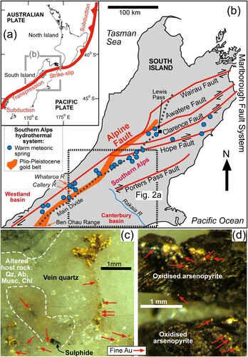
Figure 1. A,B, Tectonic setting on oblique convergent plate boundary for the Southern Alps and Canterbury basin in relation to the late Cenozoic tectonic-hydrothermal system that has emplaced orogenic gold sources for detrital gold in rivers. C,D, Examples of hydrothermal gold from the Callery River, located northwest of the Main Divide. C, Coarse and fine gold associated with hydrothermally silicified schist breccia on margin of a quartz vein (Qz = quartz; Ab = albite, Musc = muscovite, Chl = chlorite). (d) Fine gold associated with oxidised hydrothermal sulphides.
General setting
The active Pacific-Australian tectonic plate boundary passes through the South Island with a southwestwards transition from predominantly strike-slip to oblique convergence (A,B; Norris et al. Citation1990; Wallace et al. Citation2007; Cox and Barrell Citation2007; Upton et al. Citation2009; Craw et al. Citation2013). Fault activity began in the mid-Cenozoic and Southern Alps mountains have been uplifted since the Pliocene on the southeastern side of the plate boundary in the South Island, along the Marlborough Fault System and the Alpine Fault (B; Norris et al. Citation1990; Wallace et al. Citation2007; Upton et al. Citation2009; Craw et al. Citation2013). Basement rocks in the mountains are part of the Mesozoic Torlesse composite terrane (Cox and Barrell Citation2007). These metasedimentary rocks range in metamorphic grade from unfoliated prehnite-pumpellyite facies greywacke (lithic feldsarenite) and argillite (mudstone) to upper greenschist facies schists (Norris et al. Citation1990; Cox and Barrell Citation2007). Southeast of the topographic Main Divide, the basement is predominantly sub-greenschist facies unfoliated or weakly foliated Torlesse rocks (Templeton et al. Citation1999; Becker et al. Citation2000; Cox and Barrell Citation2007). Remnants of Cretaceous and Cenozoic igneous and sedimentary rocks occur along the southeastern edge of the Canterbury mountains (Field and Browne Citation1989; Smith and Cole Citation1996; Cox and Barrell Citation2007).
Rise of the Southern Alps has been accompanied by development of a tectonically driven fluid flow system that has formed hydrothermal veins and associated alteration zones along the mountain belt, with associated active warm springs that emanate from the surface (B; Smith et al. Citation1996; Templeton et al. Citation1999; Becker et al. Citation2000; Craw et al. Citation2009, Citation2013; Reyes et al. Citation2010). Most of the gold deposits occur near to the topographic Main Divide in the mountains, but the belt of deposits veers towards the Alpine Fault near to the intersection between that fault and the Marlborough Fault System (B; Craw et al. Citation2009; Citation2013). Near the Main Divide, the hydrothermal system is most prominent on the northwestern side of the mountains, with only minor occurrences to the southeast of the Main Divide (Smith et al. Citation1996; Templeton et al. Citation1999; Becker et al. Citation2000; Craw et al. Citation2002). There are two principal types of hydrothermal zones: quartz veins and associated host rock silicification, and ankeritic veins (± quartz) and associated alteration zones (Smith et al. Citation1996; Becker et al. Citation2000; Craw et al. Citation2009). Ankeritic alteration has been focused on carbonate replacement of metamorphic chlorite in host rocks (Craw et al. Citation2009). The upper Rakaia valley, especially the Wilberforce tributary ( and A) has numerous quartz veins that were mined for gold historically (Williams Citation1974; Becker et al. Citation2000).
Figure 2. Location, topography, and sedimentation in the Rakaia River catchment. A, Digital elevation model (DEM; from geographx.co.nz) of the Rakaia River catchment and adjacent catchments. B, Photograph, looking upstream, of Rakaia Gorge river bed. C, Oblique DEM view of Rakaia catchment from above the Canterbury basin, with exaggerated vertical scale. D, Typical Rakaia River greywacke-dominated gravel, in an exposure in a Pleistocene terrace at Rakaia Gorge. E, Low tide view of the beach immediately north of the Rakaia River mouth.
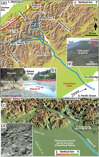
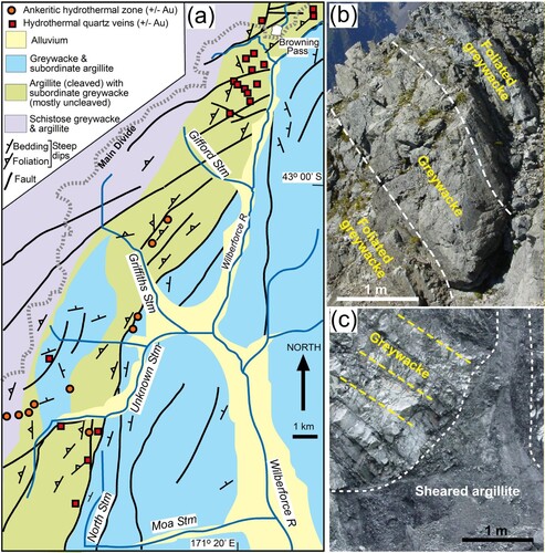
Figure 3. Structural and lithological setting for hydrothermal zones in the Wilberforce catchment. A, Geological map. B, Outcrop of partly foliated greywacke in North Stream. C, Sheared argillite with soft cataclasite cuts across unfoliated greywacke bedding in Unknown Stream.
Some hydrothermal zones, both quartz veins and ankeritic types, contain minor gold that is typically accompanied by pyrite and/or arsenopyrite (e.g. C,D). While most of the gold-bearing veins occur on the northwestern side of the Main Divide, some gold occurs to the southeast as well (Smith et al. Citation1996; Templeton et al. Citation1999; Becker et al. Citation2000; Craw et al. Citation2002). Free gold occurs in veins as coarse particles (typically 0.5-3 mm) accompanied by scattered fine (<0.2 mm) particles (C). Fine gold (commonly down to micron scale) also occurs encapsulated in sulphide minerals, and this gold is liberated as fine particles as the sulphides oxidise in outcrops (D; Chapman et al. Citation2022; Palmer and Craw Citation2024a; Palmer et al. Citation2024). The fine gold component is of particular interest in this study, as this component can be collected from localised minor concentrations in downstream sediments in the Canterbury basin (Craw et al. Citation2006, Citation2023). This is in strong contrast to the northwestern side of the mountains, where both coarse (>300 µm) and fine (<300 µm) gold have formed economic placers in the sedimentary system (Williams Citation1974; Craw et al. Citation1999, Citation2023; Roy et al. Citation2018; Palmer et al. Citation2024).
The Canterbury sedimentary basin (B) is accumulating debris eroded from the rising mountains, on top of a pre-existing Cretaceous-Cenozoic passive margin sedimentary sequence (A–E; Leckie Citation1994; Cox and Barrell Citation2007; Bender-Whitaker et al. Citation2018; Craw et al. Citation2023). The Pliocene-Holocene sediments on the onshore part of the basin are predominantly gravels and associated beds of finer particles in a wide zone of coalesced braided river plains extending from the mountains to the present sea level (A–D), with an extensive shallow sedimentary shelf beyond that shoreline (Herzer Citation1981; Leckie Citation1994; Browne and Naish Citation2003; Cox and Barrell Citation2007; Villaseñor et al. Citation2016). The gravels are dominated by coarse (5–20 cm) clasts of unfoliated greywacke (B,D,E) that are relatively competent compared to more fissile cleaved argillites and weakly foliated rocks. The river gravels have a matrix of granules, sand and minor silt (D; Kirk Citation1991) which are dominated by lithic clasts with subordinate mono-minerallic quartz, feldspar and mica clasts. Heavy minerals that accompany gold in the Rakaia River gravels are mostly derived from the sub-greenschist facies greywacke-dominated basement and include ilmenite, pumpellyite, zircon, apatite (Smale Citation1990; Lang et al. Citation2018). In addition, garnets have been contributed by remnant outcrops of garnetiferous Cretaceous rhyolite (Smith and Cole Citation1996).
The Rakaia River discharges >4 Mt of suspended sediment annually (Browne Citation2002; Hicks et al. Citation2011). The Rakaia sediment is transported by the river that currently has mean flow of ∼200 m3/sec at Rakaia Gorge, with frequent flood events that can exceed 4000 m3/sec (Hicks et al. Citation2011). Glaciers extended to the edge of the mountains in the vicinity of Rakaia Gorge several times during the Pleistocene, and remnants of tills from the Last Glacial Maximum line parts of the valley walls (C; Soons and Gullentops Citation1973; Cox and Barrell Citation2007; Hyatt et al. Citation2012). Downstream of the tills, fluvial outwash gravels form terraces up to 100 m above the present river level (C; Wilson Citation1985; Leckie Citation1994). The shoreline at the mouth of the Rakaia River has steep bars and beaches of well-sorted coarse gravel piled by storm waves, with finer gravel and sand at normal tide levels (E; Kirk Citation1991; Leckie Citation1994).
Methods
Mapping hydrothermal zones
Previous gold-related observations in the Rakaia catchment have been directed at the Main Divide headwaters of the Wilberforce River tributary (Becker et al. Citation2000), which was the principal target of minor historic mining (Williams Citation1974; Keene Citation1995). These observations were focused on large quartz veins with coarse visible gold (Becker et al. Citation2000). In this study, we extend both the area of interest and the breadth of observations on hydrothermal zones to include most of the Wilberforce catchment, and integrate that new mapping with previous work in the Upper Rakaia River (A,C). Gold distribution in the Southern Alps hydrothermal system in general is highly localised and irregular, so for the purposes of this study we did not seek specific gold localities, but documented the hydrothermal zones that are likely to contain gold in some parts. Our focus was on mapping of structure, distribution, and extents of both quartz veins and ankeritic veins and alteration zones over this larger area. The terrain is very steep and rugged, and access was primarily along river valleys and side-streams, with some ridge walking. Hence, many of the hydrothermal zones were observed from a distance, and via eroded debris.
Absolute dating of structures and hydrothermal zones is not possible, but relative dating provides some overall structural context. The studied area is crossed by numerous faults (e.g. A; Supp. Table S1), with fault zones up to 200 m wide. Some fault rocks within those zones are hard and well-lithified, and are presumed to be of Mesozoic or early Cenozoic origin. In contrast, many fault zones are defined by soft cataclasite and gouge, and are presumed to be of late Cenozoic origin. Several of these latter structures have apparently reactivated older fault zones (Supp. Table S1; Supp. Figure S1). Hydrothermal zones of interest in this study typically cut across old structures, and many are closely associated with relatively young fault zones.
Detrital gold
Gold was sampled from sediments with a gold pan, using drops of detergent to break water tension in order to save fine gold particles. Detergent was necessary for panning in both fresh (river) water and saline (sea) water. Despite this detergent precaution some small particles did escape during various stages of collection, so the final collections may be somewhat skewed against such flighty gold. Typically, gold less than 50 µm is difficult to retain in a gold pan, mainly because finer gold floats or adheres to other particles. Gold was saved at only two localities: at and above river level in Rakaia Gorge, and on the tidal beach face to the northeast of the mouth of the Rakaia River, near Southbridge (A). While panning has limitations that bulk sampling can overcome, panning is environmentally more benign. Broadly uniform results obtained from numerous panned samples in an area provide some confidence in reproducibility, and we quantify this with indications of particle numbers regulaly obtained at these two sites. Panning of river sediments at 15 sites in the Wilberforce and upper Rakaia catchments immediately downstream of hydrothermal zones was unsuccessful at detecting detrital gold. Likewise, panning sediments at five accessible sites in the main braided river valleys, both upstream and downstream of Rakaia Gorge, detected no gold. Similarly, panning of sediments from eroding Pleistocene terraces immediately upstream and downstream of the Rakaia Gorge was unsuccessful. No attempts were made to pan gold from coastal sites other than near the Rakaia River mouth where historic gold mining had occurred (Keene Citation1995).
Gold particles were mounted on aluminium stubs using double-sided carbon tape for observations on external morphology using a scanning electron microscope (SEM). The samples were not carbon-coated. Observations were made on a Zeiss Sigma VP (variable pressure) instrument at the Otago Micro and Nanoscale Imaging (OMNI) (University of Otago, New Zealand). Low-pressure nitrogen gas was added to the SEM vacuum to limit charging of non-conducting minerals. Semiquantitative analyses of gold and inclusions were obtained via energy dispersion (EDX) attachment on the same SEM, for general mineral identification. All gold examined had low but detectable Ag contents that are typical of Southern Alps hydrothermal gold (Palmer et al. Citation2024), and no attempt was made to further refine these semiquantitative analyses. Analyses of inclusions in gold were limited by their fine particle size (commonly micron scale or even smaller) in relation to the analytical electron beam size (∼3 µm). However, it was possible to identify principal minerals (quartz, albite, muscovite, pumpellyite) in some inclusions despite a high Au background. Automated element mapping of small areas of gold particle exterior surfaces had limited success because of this beam size limitation and rough surface topography.
Results
Hydrothermal zones in Wilberforce catchment
The main stem of the Wilberforce River is controlled by a north-striking fault zone that intersects a set of northeast striking faults at the Main Divide (A). East of the main stem, short tributaries feed the river from a north-trending ridge ( and A). West of the main stem, a complex set of large tributaries drains a long section of the Main Divide, cutting across the northeast striking structural grain (A). The basement is transitional from unfoliated metasedimentary rocks in the southeast to weakly foliated schists at the Main Divide (A; Supp. Table S1). The unfoliated rocks are dominated by what is called greywacke herein, a convenient field and hand specimen rock designation in the Southern Alps (Cox and Barrell Citation2007). The greywacke is Triassic lithic feldsarenite in this area, and consists of ∼50% feldspar, ∼30% quartz, and 20% lithic clasts, with micaceous minerals scattered through lithic clasts and matrix (MacKinnon Citation1983). Subordinate argillite is interlayered in greywacke-rich rock masses (A; Supp. Table S1). These rocks are faulted against a zone of argillite-dominated rocks with subordinate greywacke, interlayered on 1–100 m scale. The argillite layers are pervasively cleaved, but greywacke layers are variably foliated. Pods of greywacke have foliated margins and unfoliated massive cores, at outcrop and kilometre scales (A,B). Foliation in greywacke becomes more pervasive towards the Main Divide (A).
Faults with lithified fault rocks disrupt both greywacke and argillite, and fault zones up to 0.5 km wide locally cut across the layering but also partly control the layering orientations (Supp. Table S1; Supp. Figure S1). Late-stage faults with soft cataclasite are focused primarily in sheared argillite layers that have been extensively disrupted, causing dismemberment of more competent greywacke layers that locally transition to pods surrounded by sheared argillite (C). These faults and associated shear zones have a wide range of orientations parallel to, and across, the layering and foliation (A,B; Supp. Figure S1).
Ankeritic hydrothermal veins and alteration zones are commonly controlled by the late-stage shear zones, although not all the shear zones have ankeritic alteration (A,B and A–E; Supp. Figure S2). Many of these ankeritic zones are in, or adjacent to, argillite host rocks where deformation has been focussed (A,B). In contrast, most quartz veins are hosted in fractures that cut across competent greywacke layers (A, C,D and A). These fractures are at least partially extensional in origin, with localised open cavities into which the quartz has grown. Nevertheless, some of the quartz veins are controlled by lithologic layering and extend along sheared boundaries between greywacke and argillite.
Figure 4. Settings for hydrothermal zones in Wilberforce catchment. A, Historic site in North Stream where a gold-bearing quartz vein system was mined. B, Distant view of Main Divide above the head of Unknown Stream, showing fault-controlled orange ankeritic alteration zones. C, Sulphidic quartz vein (∼10 cm thick) coating a fracture that cuts across unfoliated greywacke bedding in Unknown Stream. D, Close view of a quartz vein in Unknown Stream, with brecciated margins and sulphidic wall rock alteration zone.
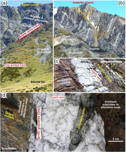
Figure 5. Contrasting hydrothermal breccia textures in Wilberforce catchment. A, Silicified and sulphidic breccia on margin of a quartz ± albite vein cutting greywacke and argillite, Unknown Stream. B, Ankeritic alteration zone in soft cataclasite cutting unfoliated greywacke, Unknown Stream. C, Breccia with ankeritic cement and minor quartz, cutting unfoliated greywacke, Unknown Stream. D, Silicified greywacke breccia with coarse sulphides on margin of gold-bearing quartz-albite vein (Qz,Ab), Wilberforce headwaters. E, Photomicrograph (crossed polars) of coarse grained hydrothermal albite and medium grained hydrothermal quartz in a vein enclosing a greywacke clast with ankeritic alteration. Gold-bearing vein, Wilberforce headwaters. F, Sulphidised argillite clasts on margin of gold-bearing quartz-albite vein, Wilberforce headwaters. Gold is not visible, but is associated with the oxidised sulphides.
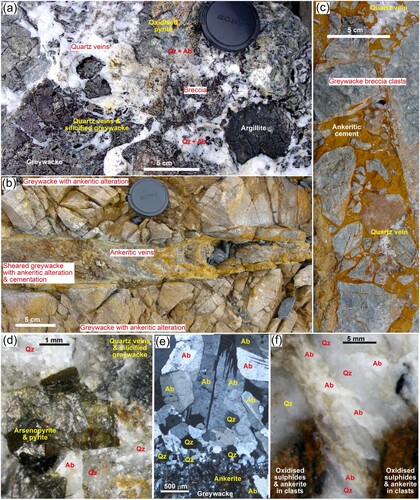
Most quartz veins have only minor albite on margins with host rock breccia clasts (C,D and ). Some quartz veins are up to half hydrothermal albite that is intergrown with the quartz (D–F; Supp. Figure S2). Many vein margins are brecciated and diffuse, with silicified host rocks and rock breccia clasts mixed with quartz and some albite (D and A,D–F; Supp. Table S1, Figure S2). Relict metamorphic minerals, especially albite, pumpellyite, muscovite and chlorite, have been incorporated into the silicified vein margins. However, ankerite replaces chlorite in some veins and alteration zones (Supp. Table S1). These complex alteration zones commonly have hydrothermal pyrite, locally accompanied by arsenopyrite and other sulphides (D and A,D–F; Supp. Figure S2). Most of the known gold-bearing veins are of this latter type ( and ; Supp. Table 1, Figure S2).
Ankeritic veins and associated alteration zones include breccias similar to the quartz veins, and some of the known gold-bearing quartz veins also contain ankerite (Supp. Table S1, Figure S2). However, quartz is less abundant in many ankeritic zones and the breccias are cemented principally by ankerite (B,C). The veins incorporate host rock fragments and host rock metamorphic minerals (B,C). Metamorphic chlorite in the clasts and some host rocks has been partially or fully altered to ankerite as a result of hydrothermally related carbonation (Supp. Figure S2). Pyrite accompanies ankerite in some cemented breccias, and oxidation of both these minerals causes the extensive orange staining of vein zones and adjacent rocks (B and B,C). Similar sulphide-bearing ankeritic breccias are known to host gold elsewhere in the Southern Alps (Smith et al. Citation1996; Templeton et al. Citation1999; Craw et al. Citation2008). No gold has yet been found in these ankerite-dominated veins in the Wilberforce catchment, but such occurrences are highly likely, and gold does occur with ankerite-bearing quartz veins (Supp. Table S1, Figure S2; Becker et al. Citation2000).
Hydrothermal zones in Upper Rakaia River
The upper Rakaia River is a long reach of the river that flows sub-parallel to the Main Divide upstream of the confluence with the Wilberforce River (A,C and ). The headwaters of the river are at least partially controlled by faults that are parallel to the Main Divide (A). The basement consists of similar sub-greenschist facies metasedimentary rocks to those of the Wilberforce catchment, but the transition from unfoliated to weakly foliated rocks is more abrupt and defined by faults (A).
Figure 6. Lithological and structural setting for hydrothermal zones in the Upper Rakaia catchment. A, Geological map modified after Craw et al. (Citation2002). B, Photograph of ankeritic alteration in a mountain face between Lyell and Ramsay Glaciers. C, Photograph of hydrothermally bleached and Fe-stained fault zones, to east of Ramsay Glacier.
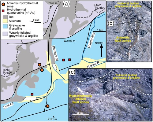
Hydrothermal zones of the upper Rakaia area are structurally and mineralogically similar to those of the Wilberforce catchment but distinctly less abundant and less extensive. In particular, cross-cutting late-stage quartz veins are relatively rare. Only one zone of sulphidic quartz veins and associated silicified schist, with minor anomalous gold, was observed between Ramsey Glacier and Louper Stream tributaries (A). Likewise, ankeritic veins and alteration zones (e.g. B) are relatively rare compared to the Wilberforce catchment. Less intensive and more diffuse zones of hydrothermal alteration occur, with only minor vein formation, along some fault zones (C).
Rakaia Gorge sediments and detrital gold
The Rakaia Gorge is a narrow section of the river valley where the active river has incised through late Pleistocene gravels to an erosionally resistant ridge of Cretaceous volcanic rocks (A–D; Supp. Figure S2). The river winds through the gorge, with banks of coarse greywacke-dominated gravel on either side that abut against outcrops of volcanic rocks, especially rhyolite (B; Supp. Figure S3). Silty medium-fine sand is deposited at higher levels along the gorge margin by floods (B), including into potholes and crevices in the rock walls (Supp. Figure S3). Bulk sediment at this site consists of 27% quartz, 32% feldspar, and 31% phyllosilicates (XRD analysis, Villaseñor et al. Citation2015), although most of these minerals are contained in polyminerallic clasts. The heavy mineral suite is dominated by sand containing Fe-Ti oxides, pumpellyite, apatite and zircon, with rare thorite, that have been liberated from the Mesozoic metasedimentary basement or the nearby Cretaceous volcanic rocks (Supp. Figure S4). The rhyolite at the gorge contains garnets, and these garnets contribute to the sandy heavy mineral suite as angular fragments in the adjacent river sediments (Supp. Figure S4).
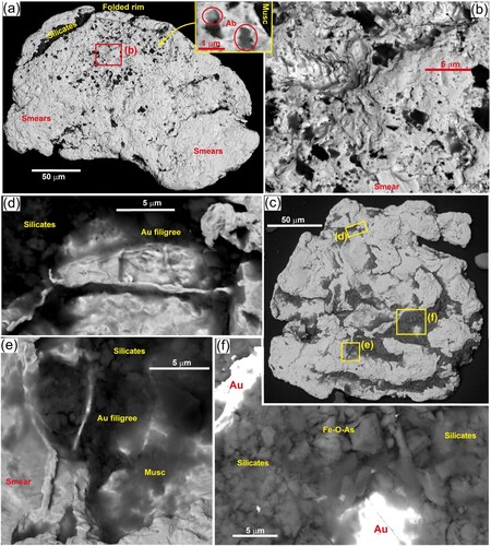
Detrital gold is sparsely present in sandy gravels at river level where gravel bars overlap exposures of rough bedrock surfaces. The gold occurs with the heavy mineral suite, as >5 particles per gold pan sample. The panned gold is all between ∼200 and ∼100 µm (fine sand), and occurs as irregularly shaped but rounded particles ( and ). The surfaces of the particles are variably deformed at the 10 µm scale, resulting in smoothing of outer edges ( and A–D). This deformation is ductile in nature and results in surficial mylonitic grain textures (Kerr et al. Citation2017), and this process is referred to as smearing herein. The smearing of the surfaces by impact with other detrital material during transport leaves haphazard striated and gouged imprints of impact events ( and ). Several generations of overlapping smears with differing directions of impact are common (C,F and ). Rims of particles have been locally folded and thickened ( and ,G).
Figure 7. External morphology of detrital gold from Rakaia Gorge sandy gravel bar. A, Equant particle. B, Equant particle with protrusion. C, Folded rim of particle in b, with mineral inclusions (Ab = albite; Qz = quartz;) and muscovite adhering to surface. D, Incipiently smeared and deformed surface partially covering porous gold. E, Elongate particle. F, Multiply smeared edge of particle in E. G, Multiple superimposed smearing features on the end of particle in e largely covers porous gold (centre left).
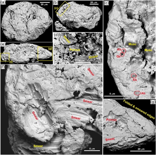
Despite the abundant surficial deformation, most of the gold particles retain some evidence of earlier textures, possibly of primary origin, in embayments of the surface that have been protected from deformation ( and ; Supp. Figure S4). The most prominent of these relict features is internal porosity at the micron scale or even smaller, in unsmeared rough surfaces (e.g. B; Supp. Figure S4). Remnants of this texture can be seen through windows where smears only partially obscure these earlier surfaces (D,G and ; Supp. Figure S4). This porosity consists of irregularly shaped holes in the surface, and similar surficial depressions that are filled with silicate minerals (B; Supp. Figure S4). Identification of these sub-micron silicates was difficult with a 3 µm SEM beam size, but numerous particles were positively identified as albite (B). Other minerals tentatively identified by SEM include quartz, muscovite, chlorite, and pumpellyite. Similar but more sparsely distributed mineral inclusions occur within some smeared and deformed gold (e.g.; albite and quartz; C). In addition, some larger (>2 µm) particles of muscovite adhere to the exterior surfaces of deformed areas of particles (C).
Figure 8. Porous features in detrital gold from Rakaia Gorge sandy gravel bar. A, Equant particle with some preserved porous areas. B, Close view of porous surface in a, showing micron-scale pores and albite (Ab) inclusions. C, Slightly flattened particle with smearing across the porous texture. D, Close view of particle in C, showing smears over pores and silicate inclusions.
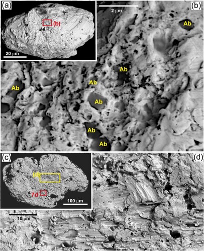
Silty sand that was deposited by floods in small depressions in the rhyolite bedrock up to a metre above the gravel bars (B; Supp. Figure S3) also contains detrital gold. This gold is sparser than in the gravel bars, yielding 1–3 particles per pan sample, but the accompanying heavy mineral suite is essentially the same as in the gravel bars. The flood-deposited gold has the same external deformation textures as the gold in the gravel bars, although the overall particle shapes are more irregular (A–F; Supp. Figure S5). However, some of the flood-deposited gold particles appear to retain more of the inferred primary features, especially porous surfaces with micron-scale silicates that are predominantly albite (e.g. A,B), than the gold in the gravel bars. In addition, depressions in one flood-deposited gold particle surface have delicate micron-scale filigree-like gold textures that are intergrown with silicates (C–E). This particle also has abundant other silicate inclusions, locally with intergrown Fe-As-O material (C,F) that may be a scorodite-like oxidation product of arsenopyrite.
Figure 9. External morphology of detrital gold from Rakaia Gorge flood-derived silty sand. A, Flattened particle with folded rim and abundant porous surface areas. Inset shows micron-scale albite inclusions. B, Close view of some porous surface area in a, showing possible primary smooth surfaces that host the pores and mineral inclusions. C, Irregularly-shaped equant particle with abundant silicate inclusions. D, Close view of filigree-like gold surface structures on the margin of a silicate-filled depression in C. E, Close view of filigree-like gold structures intergrown with silicates in particle in C. F, Silicates and oxidised As-bearing sulphide material in a depression in surface of particle in C.
Beach sediments and detrital gold at Rakaia River mouth
Sediments carried by the Rakaia River to the sea are discharged through a barrier bar at the river mouth and migrate along the coast to the northeast via longshore drift driven by a general northeasterly directed ocean current (A; Supp. Figure S6). Large volumes of coarse gravel have accumulated as storm deposits that form a ridge above tidal level along the coast near Southbridge (A,E; Supp. Figure S6). The seaward face of this ridge is a steep beach with medium to fine gravel and sand that is regularly reworked by the surf during normal tidal fluctuations (E; Supp. Figure S6). Small (metre scale) patches of wind-blown sand accumulate in shallow depressions on the crest of the storm gravel deposits (Supp. Figure S6). Sandy gravel on the tidally-influenced beach face contains heavy mineral concentrates (Supp. Figure S6), although these concentrates are not sufficiently developed to be visible in situ. The concentrates, which are gold-bearing (A), are dominated by heavy mineral sand that contains Fe-Ti oxides, pumpellyite, apatite and zircons, with rare thorite, and also contain abundant garnets (Supp. Figure S6). Variably oxidised pyrite cubes (A) are a minor component but appear in many panned samples.
Figure 10. External morphology of detrital gold from tidal sandy gravel on beach northeast of the Rakaia River mouth. A, Incipiently flattened particle with folded rims. Inset shows typical accompanying heavy mineral suite: P = oxidised pyrite pseudomorph; G = garnet; Z = zircon; Fe = Fe-Ti-oxide. B, Close view of relict porous area in gold particle in a, showing micron-scale albite (Ab) and quartz (Qz) inclusions visible through some smeared and smoothed surfaces. C, Folded rim of particle in A. D, E, Irregularly shaped particles with folded rims, smeared and smoothed surfaces, and some relict porous areas. F, Close view of boundary between deformed margin and a relict porous area in E. G, Irregularly shaped particle with folded rims and some relict porous areas.
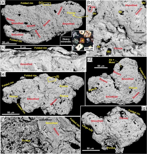
Detrital gold is a rare component of the heavy mineral suite (A–G), and the sites examined for this study yielded zero to two particles per pan sample. The gold consists of ∼200–100 µm (fine sand) particles that are generally flakier in shape than at the Rakaia Gorge but still retains irregular margins (A–G). Beach gold particle surfaces show similar deformation features to the Rakaia Gorge samples, especially abundant smearing at the ten-micron scale (A–G; Supp. Figure S7). However, the beach gold also has notably smooth surfaces over parts of the particles, resulting from fine-scale smearing (A–G; Supp. Figure S6). Beach gold particle rims are folded at the 2–20 micron scales, although these folds are smoothed as well (A–G). Despite the abundant deformation-induced surface modification, beach particles still retain some of the primary porous textures with micron-scale silicate inclusions, especially albite (A,B, D–G; Supp. Figure S7), that is seen in most particles at Rakaia Gorge ( and ).
Discussion
Morphological evolution of detrital gold
Known hydrothermal gold in the Southern Alps is typically broadly equant in shape with irregular margins (e.g. C,D; Becker et al. Citation2000), and this is the likely shape of the sourced detrital gold in the Rakaia catchment. The hydrothermal gold generally accompanies sulphides that occur on and near margins of veins, associated with host rock breccia fragments (e.g. C) or in altered host wall rocks (e.g. and ; Supp. Figure S2). Hence, there is a close association between gold and host rock silicate minerals, and in the Rakaia catchment this has apparently resulted in abundant silicate inclusions in the gold at sources and in detrital particles (). In particular, the widespread occurrences of micron-scale albite appears to be a distinctive feature of the gold in the Rakaia catchment (). Hydrothermal albite is a major component of some mineralised quartz veins in the Wilberforce headwaters (D–F; Supp. Figure S2; Becker et al. Citation2000), and host rock albite is preserved in wall rock alteration zones in both the quartz vein and ankeritic hydrothermal zones (Craw et al. Citation2009).
Arsenic-bearing oxidation residues in one Rakaia Gorge detrital particle attest to primary association with sulphides, with subsequent oxidation contributing to the porous nature of the gold (C,F). Square shapes in filigree-like gold may also indicate that euhedral pyrite was originally present (C–E). Coarse pyrite pseudomorphs in the detrital heavy mineral suite (A) support this assertion. Hence, we conclude that fine gold shed from Rakaia River hydrothermal systems was irregular but broadly equant in shape and had porous textures resulting from abundant small silicate inclusions and voids where silicates have been removed and/or sulphides have been oxidised. It is possible that some silicates have been pressed into cavities in the gold during fluvial transport. but in the observed textures the surface smears and folded rims appear to have fewer exposed silicates, not more, and silicate-free smears appear to be covering protected areas of silicate-rich areas of the gold (; Supp. Figure S4,5,7).
Long distances (tens of km) of fluvial transport of gold generally result in formation of well-defined flaky morphology (Knight et al. Citation1999; Youngson and Craw Citation1999; Townley et al. Citation2003; Chapman et al. Citation2022). The Rakaia River detrital gold has undergone some flattening during transport, but no particles collected in this study were thin flakes (; Supp. Figure S5). The flattest particles occur in the beach face sediments, but even these particles are still irregular in shape (A–G). This contrasts strongly with the presence of well-defined thin flakes that occur in wind-reworked beach sand deposits near the top of the storm beach ridge (e.g. Supp. Figure 6; Craw et al. Citation2006). The latter wind-reworked flakes are rare in these sands (zero-one particle per pan sample; Craw et al. Citation2006). Hence, there may be some preferential mobilisation of flakier beach face particles by the wind, followed by sand-blasting that caused incipient toroidal modification (cf. Palmer and Craw Citation2024b). Also, some flaky beach face gold may have escaped the sampling process as this fine gold is notorious for floating on water surfaces (Palmer and Craw Citation2024b). None of our observed beach gold particles have any evidence for toroidal morphology development that is characteristic of wind-driven sand-blasting (Palmer and Craw Citation2024a, Citation2024b; Palmer et al. Citation2024), although incipient toroidal deformation was noted on the rims of flakes in the wind-reworked beach sands at this site (Craw et al. Citation2006).
Apart from moderate flattening of detrital particles, the principal effects of downstream transport have been smearing deformation of the gold surfaces at the 10 µm scale. The smears have formed at a range of overlapping angles (; Supp. Figures S4, S5, S7). This smearing was accompanied by folding and smearing of particle rims, also at the 10 µm scale (; Supp. Figures S5, S7). This small-scale deformation has led to smoothing of some surfaces of the beach gold (; Supp. Figure S7). Nevertheless, the micron scale porous textures of the primary gold have apparently persisted to some extent in all the observed detrital particles, from upstream sources to the beach face (; Supp. Figures S4, S5, S7).
Fine gold transport
Considering the long distances involved (>100 km), the steep terrain, the coarse grained bed-load components, and the high energy river and coastal environments (A–E), the modification of the fine Rakaia gold morphology is surprisingly minor compared to detrital gold observed elsewhere (Knight et al. Citation1999; Youngson and Craw Citation1999; Townley et al. Citation2003; Chapman et al. Citation2022; Palmer and Craw Citation2024a). In particular, there are stark differences between the Rakaia gold and the predominance of highly deformed and flattened flakes that have formed from essentially the same gold sources during relatively short transport on the northwestern side of the mountains (Palmer et al. Citation2024). Transport for part of the distance, to Rakaia Gorge, by glaciers may be one explanation for this relative lack of modification (A). However, glacial transport on the northwestern side of the mountains apparently did not ameliorate particle deformation to form flakes (Palmer et al. Citation2024).
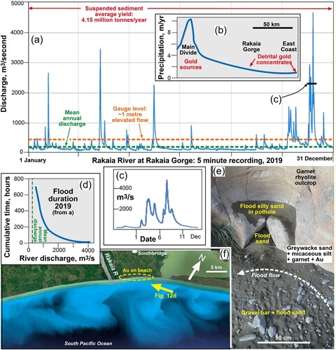
Alternatively, or as well, the fine detrital gold may have been transported in suspension, or even floated on the river surface. This mode of gold transport has been recently demonstrated in turbid silty water at the small scale of a gold mine processing plant (Palmer and Craw Citation2024c). The Rakaia River carries only fine silt at medium to low flows (Supp. Figure S3) but the river is subject to major flood events with 10–20 times the mean annual discharge, at times exceeding 4000 m3/s (A; Supp. Figure S8; Browne Citation2002; NIWA Citation2024). These short (hours to days) but large flood events are driven by westerly wind driven precipitation and snow-melt in the headwaters where the detrital gold is sourced (A–D). These events are the most likely periods when much of the suspended sediment is discharged (A–F; Supp. Figure S8), and the times when detrital gold could be carried in suspension. Such events, and sequences of events, lead to emplacement and concentration of the flood-transported gold that occurs in silty sand more than 1 m above normal river levels at Rakaia Gorge, for example (B, and ; Supp. Figures S3, S5). The frequency of events >1 m above normal levels, during which sand and gold may be carried in suspension, is indicated in A based on river gauge levels in Rakaia Gorge (Supp. Figure S8).
Figure 11. Rakaia River flood and suspended sediment discharges. A, Hydrograph for the river discharge at Rakaia Gorge (NIWA Citation2024) for the year 2019 (a representative year; see Supp. Figure S8), showing height and duration of flood events in relation to mean annual discharge, and average annual suspended sediment discharge (Hicks et al. Citation2011). B, Generalised precipitation profile down the Rakaia catchment, showing the predominance of precipitation near the Main Divide, with a steep decreasing gradient towards the coast. C, Expanded time scale for a single late spring flood period, showing event duration. D, Cumulative time (hours) for duration of floods at various levels above 500 m3/s during 2019 (as in A). E, Sandy deposits from suspension in floods at Rakaia Gorge, deposited on a gravel bar at the base of an outcrop (top) with potholes. F, Google Earth view of coastal suspended sediment plumes at the mouth of the river.
The morphological similarities between the flood-deposited gold and the gold from gravel bars (; Supp. Figures S4, S5) and also on the ocean beach face (; Supp. Figure S7), suggest that suspension processes may carry most of the detrital gold in the river (A,B). The abundant silicate inclusions and porous nature of the fine gold must lower the bulk density of the particles. Further, gold particles can have a negative electrostatic surficial charge (Monte et al. Citation2000) at the neutral-alkaline pH of Rakaia River water, so it is therefore possible that the fine gold may be electrostatically attracted to positively charged surfaces of platy minerals such as micas, further lowering the composite particle density. For example, muscovite adheres to the deformed surfaces of some gold particles (C and E; Supp. Figure S5), bulk XRD analyses of Rakaia River sand sampled at the gorge is rich in mica (17%; Villaseñor et al. Citation2015), and XRD analyses of clay-mineral fractions deposited offshore from Rakaia River suspended-sediment plumes (F) indicate that they are predominantly micaceous (Churchman et al. Citation1988). The electrostatic surface properties of fine gold also make it hydrophobic, and that hydrophobicity is enhanced by mechanical deformation (Allan and Woodcock Citation2001) such as the surficial smearing on the fine gold surfaces (), possibly facilitating flotation of fine gold on the river surface.
Figure 12. Depictions of regional tectonic and sedimentological context for detrital gold in the Rakaia catchment. A, Cartoon (not to scale) showing inferred contrast in transport processes for fine gold (with sand, silt and clay in suspension) and detrital garnets (with sand and gravel in bedload) during Rakaia River floods, resulting in contrasts in amounts of morphological modification. B, Cartoon cross section of the Rakaia catchment (not to scale) showing gold sources, abundant sedimentary dilution, and localised re-concentration points, with the context for flood movement of sediments in A. C, Main Divide source area at head of Wilberforce River, showing possible past and future river capture events. Divide-parallel reaches west of the divide may have been previously captured, sending gold down towards the West Coast (green streams). Future capture events of divide-parallel reaches of Wilberforce (blue streams) may remove all the gold-bearing vein swarm from the Rakaia catchment. D, Oblique view of Rakaia River mouth and beaches (from Google Earth), showing the inferred gold transport and re-concentration processes. Beach in foreground is ∼100 m wide.
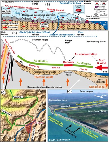
Heavy minerals are commonly separated and concentrated in sedimentary systems by differences in a range of physical properties, especially density and shape, leading to sorting via hydraulic equivalence (Resentini et al. Citation2013; Dill Citation2018). However, detrital gold rarely, if ever, responds to these parameters and gold particles, despite their very high density (∼19 g/cm3), are commonly of similar size to associated lower density (<5 g/cm3) heavy minerals (e.g. A; Supp. Figure S6). Gold hydrophobicity and electrostatic adherence of micas to gold particles may be responsible for at least some of this clear deviation of gold particles from hydraulic equivalence. Further, the high sediment load of the Rakaia river that raises water density during floods could facilitate long distance transport of fine gold above the tumbling bed-load, with relatively little morphological modification (A,B). On a smaller scale, similar transport of fine gold with adhering phyllosilicates in clay-rich silty suspension has been shown in a gold mine processing plant, where the strong deviation from hydraulic equivalence makes fine gold difficult to extract (Palmer and Craw Citation2024c).
Concentration of the fluvial detrital gold on the beach northeast of Rakaia River mouth occurs via surf reworking and wind winnowing (B; Supp. Figure S6). The surf concentration processes are especially effective for enriching garnets in the heavy mineral component of the sediments (A; Supp. Figure S6), although garnet-bearing rocks make up a very small proportion of the basement in the Rakaia catchment (A,B; Supp. Figure S3; Smith and Cole Citation1996; Cox and Barrell Citation2007). These beach garnets are rounded or sub-rounded, and have clearly been severely abraded during transport (A; Supp. Figure S6; Resentini et al. Citation2013, Citation2018), compared to their angular textures at their Rakaia Gorge source (Supp. Figure S4). Concentration of detrital gold has been less effective, and gold is relatively rare in these garnetiferous beach sediments. The contrasts in abundant concentration and transport abrasion of garnets (Moh hardness ∼7) and relatively minor surface smearing of rare gold (Moh hardness ∼2.5) on the beach face may arise because these minerals were transported to the coast by different fluvial processes: garnet in bed-load, and gold in suspension (A,B). Similarly, detrital thorite (Moh hardness ∼5) is more rounded on the beach than at Rakaia Gorge and may have accompanied garnet rather than gold in the fluvial system (Resentini et al. Citation2013, Citation2018), although only two thorite particles are compared in this study (Supp. Figures S7 vs S4).
Tectonic controls on hydrothermal gold distribution
The primary control on gold distribution and concentration is the development of the auriferous orogenic hydrothermal systems along the mountains (B; Craw et al. Citation2002, Citation2009, Citation2013). These tectonic-hydrothermal systems have emplaced gold on both sides of the Main Divide, although mostly on the northwestern side, in the obliquely convergent part of the plate boundary (A,B; Craw et al. Citation2013). The tectonic-hydrothermal systems are more complex and diffuse in the transition to the strike-slip part of the plate boundary (Marlborough Fault System; A,B; Craw et al. Citation2013). This change in general hydrothermal style occurs near to the intersection of the Alpine Fault and the Hope Fault, where the main focus of hydrothermal alteration migrates away from the Main Divide towards the Alpine Fault, and the zone of warm springs migrates in the opposite direction (B). The gold-mineralised headwaters of the Rakaia River, especially the Wilberforce tributary, occur close to this transition where the hydrothermal fluid flow and mineralisation processes appear to have been particularly focused (B and A; Becker et al. Citation2000; Craw et al. Citation2013). Immediately southwest of the Rakaia catchment, mineralisation appears to have been confined to the northwest side of the Main Divide, and north of the Rakaia catchment the whole mineralised belt lies to the west of the Main Divide (B). Hence, no detrital gold occurs in rivers draining to the Canterbury basin on either side of the Rakaia catchment (B and a).
The drainage configuration of gold-bearing river catchments in the mountains is subject to change in the dynamic tectonic and erosional environment. There are major contrasts in rainfall and associated erosion across the Main Divide, with relatively high erosion rates on the northwestern side (B; Griffiths and McSaveney Citation1983; Koons Citation1995; Cox and Barrell Citation2007). Consequently, tectonic motion is driving the drier eastern landscape southwestwards towards the zone of higher erosion, resulting in capture of some headwaters of eastern rivers by northwest-draining rivers (Koons Citation1995; Craw et al. Citation2008). Many reaches of rivers southeast of the Main Divide are oriented subparallel to the divide, whereas the main drainages northwest of the Main Divide are oriented perpendicular to the divide (Koons Citation1995; Craw et al. Citation2008). River capture events at the Main Divide result in transfer of divide-parallel river reaches to the northwestern side of the divide (C; Koons Citation1995; Craw et al. Citation2008).
These river capture processes are probably responsible for the divide-parallel reaches of the headwaters of the Arahura and Kokatahi Rivers, across the divide from the Wilberforce headwaters (A and C). The lower reaches of these northwest-draining rivers have been important sources of placer gold historically (Williams Citation1974), and this gold was presumably derived from the tectonic-hydrothermal systems in their Southern Alps headwaters, including the swarm of quartz veins that extends to the Main Divide from the Wilberforce catchment (C). On-going oblique tectonic convergence and erosion will inevitably result in further capture of upper reaches of the Wilberforce catchment and its gold deposits by these two northwest-draining rivers (C). Similar processes will inevitably affect the divide-parallel Upper Rakaia River (A,C and A). Hence, the amount of detrital gold being shed down the Rakaia River to the Canterbury basin will diminish over time unless new sources are exposed by erosion. The time frame for drainage reconfiguration is not well defined, but an equivalent capture event at Lewis Pass (B) has been estimated to have occurred <100 ka (Craw et al. Citation2008).
Detrital gold concentration in the Canterbury sedimentary basin
The seaward parts of the Canterbury basin contain a ∼2 km thick sedimentary pile, half of which has accumulated during the Pliocene to Holocene rise of the Southern Alps (Cox and Barrell Citation2007; Bender-Whitaker et al. Citation2018; Craw et al. Citation2023). The Plio-Pleistocene hydrothermal gold that has been exposed to the southeast of the Main Divide during this mountain uplift and erosion has been eroded and incorporated into the greywacke-clast dominated gravels of the fluvial and littoral elements of the Rakaia River system (D and B). Active uplift in the Rakaia catchment between the Main Divide and the mountain front is driven by deformation associated with the Alpine Fault (A,B; Supp. Figure 9). Simple mass balance at outcrop scale, supported by direct field observations, indicate that incorporation of the detrital gold into the erosional gravels is primarily a dilution process (B; Craw et al. Citation2023).
Sedimentary dilution of detrital gold begins in the colluvium slopes and alluvial fans at the foot of the mineralised mountain ridges (e.g. A). However, at this stage, most gold is likely to be encapsulated in coarse silicate-rich debris, and further downstream comminution is needed to liberate free gold particles in these proximal mountain environments (several km; A,B; Youngson and Craw Citation1999). Further dilution occurs as sediments from mineralised tributaries converge with sediments from adjacent less-mineralised tributaries as the braided river system evolves downstream and eventually discharges to the sedimentary basin (A,C). Consequently, placer gold concentrations are largely absent along the >100 km length of the Rakaia River catchment (B). The two exceptions to this general dilution trend, as described in this study, are located at the point in the river (Rakaia Gorge) where minor concentration can occur, and on the beach immediately beyond the river mouth (A–E, and ,B,D).
The Rakaia Gorge has been formed where the basement and Cretaceous volcanics are being uplifted at the mountain range front, with active faults enhancing the range front uplift zone (A–C; Supp. ). This bedrock step provides a site at which some winnowing of passing gravels can occur, allowing minor gold concentration. In addition, crevices in the bedrock can trap gold particles in suspension in flood waters (B and E). The trapped and concentrated gold particles are all finely particulate (mostly very fine sand; and ), indicating that coarse gold, that is known to exist in the headwaters (Williams Citation1974; Keene Citation1995; Becker et al. Citation2000) has been retained in diluted form farther upstream (A,B). The source(s) of the fine gold concentrated at Rakaia Gorge cannot be defined with confidence, although the ultimate sources must lie within the hydrothermal systems near the Main Divide (A and A). Some detrital gold may have been derived directly from these hydrothermal zones, but it is likely that some gold has been recycled from the remnants of glacial deposits that occur down the valley to the Rakaia Gorge (C and A; Cox and Barrell Citation2007; Hyatt et al. Citation2012; Lang et al. Citation2018).
The presence of detrital gold at the coast demonstrates that long-distance fluvial transport is occurring (A,B,D). However, while the ultimate sources are >100 km upstream near the Main Divide, it is possible that there are intermediate sources as well, in the Pleistocene tills and gravel terraces along the modern river margins (A,C). The Pleistocene terraces formed by aggradation of gravels during glacial periods, and subsequent tectonic uplift, sea level changes, and changing sediment loads have contributed to incision of the modern broad braided channel into these older terraces, as well as Pleistocene or Holocene sediments above the Rakaia Gorge (above; C and D; Supp. Figure S3; Wilson Citation1985; Leckie Citation1994; Lang et al. Citation2018). This erosion of older sediments almost certainly remobilises some detrital gold into the modern river (A).
Detrital gold concentration on west side of Main Divide
The extremely limited gold concentration process in what is a net dilution fluvial-littoral system along the Rakaia River contrasts strongly with gold concentration in the sedimentary system on northwest side of the Southern Alps (). Some sediments accumulate in Westland on a narrow coastal strip to the northwest of the Alpine Fault, but most are transported offshore (Roy et al. Citation2018; Craw et al. Citation2023; Palmer et al. Citation2024). The high rainfall (B) and short steep rivers (A and ) move large volumes of sediment into the basin during frequent flood events. In addition, the western side of the mountains is being uplifted more rapidly than the east side, while rapid erosion is maintaining the steep western river profile (; Norris et al. Citation1990; Craw et al. Citation1999; Roy et al. Citation2018). The gold-bearing Hokitika River, for example, flows westwards from immediately across the Main Divide from the Rakaia catchment (A). This river has mean annual suspended sediment discharge of 6.2 Mt, half again as much as the Rakaia, despite have only a sixth of the Rakaia’s catchment area and half the Rakaia’s mean annual flow (Hicks et al. Citation2011). Heavy minerals reaching the western coastal beaches are similar to those of the Rakaia catchment, except that epidote, rather than pumpellyite, is the principal Ca-Al-Fe silicate, and garnets are derived from high-grade schist basement rather than from Cretaceous rhyolite (; Ritchie et al. Citation2019).
Figure 13. Comparison between Rakaia River and coastal gold transport (right; this study) and gold transport in rivers and beaches on the western side of the Southern Alps (left; Palmer et al. Citation2024), all derived from similar hydrothermal sources. Red text = comments about gold; Green text = comments about heavy minerals; Blue text = comments about transport/depositional setting and processes. A, A generalised river profile across the mountains showing contrasting gradients and distances, and underlying basement contrasts yielding similar but not identical associated heavy mineral suites. B, Stereomicroscope light view of fluvial gold from Whataroa River (B). C, D, SEM backscatter electron images of beach gold from near Lake Mahinapua (A). E, Stereomicroscope light view of detrital gold from Rakaia Gorge. F, SEM backscatter electron image of detrital gold from Rakaia Gorge. G, Stereomicroscope light view of beach gold from Rakaia River mouth. H, I, SEM backscatter electron images of beach gold from Rakaia River mouth.
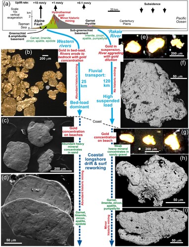
These dynamic processes have facilitated formation of fluvial placers onshore on the western side of the mountains that include both coarse (>300 µm) and fine (300–350 µm) gold particles (; Williams Citation1974; Craw et al. Citation1999; Palmer et al. Citation2024). Western rivers erode to bedrock in the mountains to form steep gorges down which gold is transported primarily in bed-load and has been locally concentrated in thin fluvial gravel veneers (; Craw et al. Citation1999; Roy et al. Citation2018; Palmer et al. Citation2024). As a result of these processes, most detrital gold has been hammered into thin flakes (; Palmer et al. Citation2024). Sandy Westland beaches with powerful surf from the Tasman Sea are effective at further concentrating this flaky gold, along with garnets and ilmenite, into well-defined layers rich in heavy minerals, and these have been of long-term economic significance (; Williams Citation1974; Ritchie et al. Citation2019; Palmer et al. Citation2024). While the particle sizes of western beach placer gold are similar to those of the beach at Rakaia mouth (<200 µm), the particle morphologies are distinctly different, reflecting the differences in mechanisms of fluvial transport to the coast (A and ). Fluvial and coastal reworking of gold-bearing glacial till deposits have also been important for creating economic placer gold deposits in the lower reaches of many Westland rivers (Williams Citation1974; Palmer et al. Citation2024), in contrast to the economically barren Canterbury Pleistocene and Holocene gravels ().
Detrital gold concentration in tectonic-sedimentary basins elsewhere
The island orogen of Taiwan has an almost identical tectonic setting to that of the South Island of New Zealand, with similar late Cenozoic hydrothermal systems near the main drainage divide (Tan et al. Citation1994; Upton et al. Citation2011). Detrital gold concentrations form on the beaches of the steep and highly uplifted eastern side of the island (Tan et al. Citation1994) that is a mirror-image equivalent of Westland in the South Island (Upton et al. Citation2011). No gold concentration is known in the highly dilutional environment on the more passive western side of the orogen that is geometrically equivalent to the Canterbury sedimentary basin (Upton et al. Citation2011).
The large foreland basins east of the North American Cordillera have small amounts of detrital gold derived from hydrothermal systems in the mountain basement rocks (Craw and Leckie Citation1996; Craw et al. Citation2006). This combination of orogenic gold emplacement and detrital gold mobility is older (Mesozoic initiation) than that of the New Zealand and Taiwan systems (Craw and Leckie Citation1996; Craw et al. Citation2006). The detrital gold is mostly diluted by the unmineralised hosting sediments, and has been locally concentrated in small paleoplacers, in a similar manner to the Rakaia River system (Craw and Leckie Citation1996; Craw et al. Citation2006). River capture events in the headwaters of gold-bearing Cordilleran rivers have diverted detrital gold westwards, away from the eastern basins (Craw and Leckie Citation1996), in a similar manner to that predicted for the Rakaia River headwaters (C). High rainfall and erosion rates coupled with dynamic surf environments have concentrated gold on some beaches on the western side of the northern Cordillera (Eyles Citation1990), similar to the processes in the Westland basin.
Conclusions
Late Cenozoic hydrothermal zones have been emplaced to the east of the Main Divide in the Rakaia River headwaters, but these are most abundant in the extensive tributary Wilberforce River catchment and are less abundant farther to the southwest in the Rakaia catchment. The hydrothermal zones consist of two types: quartz veins with sulphidic breccias and wall rocks, and ankeritic breccias and wall rock alteration zones. Minor historic gold mining occurred in a limited portion of the Wilberforce catchment, in quartz veins with coarse gold. Fine gold has been eroded from the hydrothermal zones and transported down the river for >100 km towards the present coastline in the Canterbury sedimentary basin where the upper kilometre of sediments is dominated by greywacke-derived gravels.
Neither coarse nor fine detrital gold have been concentrated in placers in the upper reaches of the catchment, where the gold is thoroughly diluted by voluminous greywacke-derived erosional debris in alluvial fans, braided river gravels, and glacial till that occurs sporadically downstream to the mountain front. Minor re-concentration of fine gold has occurred in the Rakaia Gorge at the mountain front through winnowing of gravel over exposed bedrock outcrops. Additional minor re-concentration occurs at this site where fine gold transported with sand and silt in flood waters is deposited above normal river levels. Fine gold re-concentration also occurs on beaches immediately northeast of the Rakaia River mouth where sediments are also reworked from beach deposits by southerly winds.
Gold in the primary sources was highly porous, with abundant micron-scale silicate inclusions. Albite is the most common silicate inclusion, attesting to the chemical stability and local hydrothermal addition of albite in the mineralised zones. The porous and silicate-rich micro-textures persist in the fine detrital gold right through to the beach face sediments, although the gold particles have been superficially modified by smearing and deformation of particle rims. However, the rare gold particles in the wind-reworked beach sands have more advanced flaky shapes and have lost their porous textures. The general lack of development of flake morphology and retention of primary features all the way to the beach face is in strong contrast to the evolution of gold morphology on the northwestern side of the mountains where even short distances (∼10 km) of fluvial transport and beach gold accumulation have led to abundant thoroughly deformed flaky gold.
The lack of major morphological modification of detrital fine gold in the Rakaia catchment may arise because the gold is transported in suspension in the river during floods, or even as particles floating on the water surface. Travel in suspension, with sand and silt rather than gravel, limits re-concentration processes as the gold can bypass favourable winnowing sites. In addition, river capture events in the source areas may remove gold-bearing rocks from the catchment, further reducing the supply of gold to the sedimentary basin. All these processes are likely to be common in sediment-rich fluvial systems derived from tectonically active mountains around the world. Hence, these basins adjacent to active mountains are likely to be unfavourable sites for placer gold accumulation from coeval hydrothermal gold zones. However, the presence in the basement of abundant older mineralised rocks, or overlying pre-existing paleoplacer gold deposits, may contribute to some new placer concentrations.
Acknowledgements
John Youngson contributed useful discussions on placer gold, and carefully, skilfully and laboriously panned the wind-reworked Rakaia beach gold described in Craw et al. (Citation2006). John Williams provided intrepid company in the field in the Rakaia headwaters. Stephen Read ably assisted with some digital illustrations. Scanning electron microscopy was undertaken at Otago Micro and Nanoscale Imaging (OMNI), University of Otago, New Zealand. Thorough and thoughtful reviews by G Browne and S Ando and perceptive comments by Associate Editor K Marsaglia substantially improved the presentation.
Disclosure statement
No potential conflict of interest was reported by the author(s).
Data availability statement
All data are included in this paper, the cited references, and the Supplementary Document: figshare.com/articles/journal_contribution/Rakaia_River_Gold_NZJGG_Supplementary/25988371.
Additional information
Funding
References
- Allan GC, Woodcock JT. 2001. A review of the flotation of native gold and electrum. Minerals Engineering. 14:931–962. doi:10.1016/S0892-6875(01)00103-0.
- Becker J, Craw D, Horton T, Chamberlain CP. 2000. Gold mineralisation near the Main Divide, upper Wilberforce valley, Southern Alps, New Zealand. New Zealand Journal of Geology and Geophysics. 43:199–215. doi:10.1080/00288306.2000.9514881.
- Bender-Whitaker C, Marsaglia KM, Browne GH, Jaeger JM. 2018. Sedimentary processes and sequence stratigraphy of a Quaternary siliciclastic shelf-slope system: insights from sand provenance studies, Canterbury Basin, New Zealand. In: Ingersoll RV, Lawton TF, Graham SA, editors. Geological Society of America Special Paper 540.1–38. doi:10.1130/SPE540.
- Boyle RW. 1979. The geochemistry of gold and its deposits. Geological Survey of Canada Bulletin. 280:579 pp.
- Browne GH. 2002. A large-scale flood event in 1994 from the mid-Canterbury Plains, New Zealand, and implications for ancient fluvial deposits. In: Martini IP, Baker VR, Garzon G, editors. Flood and Megaflood Processes and Deposits: Recent and Ancient Examples. Special Publication International Association of Sedimentologists; p. 99–109.
- Browne GH. 2004. Downstream fining and sorting of gravel clasts in the braided rivers of mid-Canterbury, New Zealand. New Zealand Geographer. 60:2–14. doi:10.1111/j.1745-7939.2004.tb01708.x.
- Browne GH, Naish TR. 2003. Facies development and sequence architecture of a late Quaternary fluvial-marine transition, Canterbury Plains and shelf, New Zealand: Implications for forced regressive deposits. Sedimentary Geology. 158:57–86. doi:10.1016/S0037-0738(02)00258-0.
- Chapman RJ, Craw D, Moles NR, Banks DA, Grimshaw MR. 2022. Evaluation of the contributions of gold derived from hypogene, supergene and surficial processes in the formation of placer gold deposits. Geological Society of London Special Publication. 516:291–311. doi:10.1144/SP516-2020-260.
- Churchman GJ, Hunt JL, Glasby GP, Renner RM, Griffith GA. 1988. Input of river-derived sediment to the New Zealand continental shelf: II Mineralogy and composition. Estuarine, Coastal and Shelf Science. 27:397–411. doi:10.1016/0272-7714(88)90096-0.
- Cox SC, Barrell DJA. 2007. Geology of the Aoraki area. Institute of Geological & Nuclear Sciences 1:250 000 geological map 15. 1 sheet + 71 pp. Lower Hutt: Institute of Geological and Nuclear Sciences.
- Craw D. 2010. Delayed accumulation of placers during exhumation of orogenic gold in southern New Zealand. Ore Geology Reviews. 37:224–235. doi:10.1016/j.oregeorev.2010.03.006.
- Craw D, Burridge CP, Upton P, Rowe DL, Waters JM. 2008. Evolution of biological dispersal corridors through a tectonically active mountain range in New Zealand. Journal of Biogeography. 35:1790–1802. doi:10.1111/j.1365-2699.2008.01936.x.
- Craw D, Koons PO, Horton T, Chamberlain CP. 2002. Tectonically driven fluid flow and gold mineralisation in active collisional orogenic belts: comparison between. New Zealand and western Himalaya.Tectonophysics. 348:135–153.
- Craw D, Leckie DA. 1996. Tectonic controls on dispersal of gold into a foreland basin: an example from the western Canada foreland basin. Journal of Sedimentary Research. Section A, Sedimentary Petrology and Processes. 66:559–566.
- Craw D, Phillips N, Vearncombe J. 2023. Unconformities and gold in New Zealand: Potential analogues for the Archean Witwatersrand of South Africa. Minerals. 13:1041. doi:10.3390/min13081041.
- Craw D, Upton P, Horton T, Williams J. 2013. Migration of hydrothermal systems in an evolving collisional orogen, New Zealand. Mineralium Deposita. 48:233–248. doi:10.1007/s00126-012-0421-8.
- Craw D, Upton P, MacKenzie DJ. 2009. Hydrothermal alteration styles in ancient and modern orogenic gold deposits, New Zealand. New Zealand Journal of Geology and Geophysics. 52:11–26. doi:10.1080/00288300909509874.
- Craw D, Youngson JH, Koons PO. 1999. Gold dispersal and placer formation in an active oblique collisional mountain belt, Southern Alps, New Zealand. Economic Geology. 94:605–614. doi:10.2113/gsecongeo.94.5.605.
- Craw D, Youngson JH, Leckie DA. 2006. Transport and concentration of detrital gold in foreland basins. Ore Geology Reviews. 28:417–430. doi:10.1016/j.oregeorev.2005.03.006.
- Dill HG. 2018. Gems and placers—A genetic relationship par excellence. Minerals. 8:470. doi:10.3390/min8100470.
- Eyles N. 1990. Glacially derived, shallow-marine gold placers of the Cape Yakataga district, Gulf of Alaska. Sedimentary Geology. 68:171–175. doi:10.1016/0037-0738(90)90110-F.
- Field BD, Browne GH. 1989. Cretaceous and Cenozoic sedimentary basins and geological evolution of the Canterbury region, South Island, New Zealand. Basin Studies 2, New Zealand Geological Survey, Lower Hutt, New Zealand, 94 pp.
- Garnett RHT, Bassett NC. 2005. Placer deposits. Economic Geology 100th Anniversary volume, pp. 813-843.
- Goldfarb RJ, Baker T, Dube B, Groves DI, Hart CJR, Gosselin P. 2005. Distribution, character, and genesis of gold deposits in metamorphic terranes. Economic Geology 100th Anniversary Volume:407–450.
- Goldfarb RJ, Pitcairn I. 2023. Orogenic gold: is a genetic association with magmatism realistic? Mineralium Deposita. 58:5–35. doi:10.1007/s00126-022-01146-8.
- Griffiths GA, McSaveney MJ. 1983. Distribution of mean annual precipitation across some steepland regions of New Zealand. New Zealand Journal of Science. 26:197–209.
- Groves DI, Santosh M, Goldfarb RJ, Zhang L. 2018. Structural geometry of orogenic gold deposits: implications for exploration of world-class and giant deposits. Geoscience Frontiers. 9:1163–1177.
- Henley RW, Adams J. 1979. On the evolution of giant gold placers. Transactions of the Institute of Mining and Metallurgy. 88:B41–B50.
- Herzer RH. 1981. Late Quaternary stratigraphy and sedimentation of the Canterbury continental shelf. Wellington: New Zealand Oceanographic Institute Memoir 89. Department of Scientific and Industrial Research.
- Hicks DM, Shankar U, McKerchar AI, Basher L, Jessen M, Lynn I, Page M. 2011. Suspended sediment yields from New Zealand rivers. Journal of Hydrology (New Zealand). 50:81–142.
- Hyatt OM, Shulmeister J, Evans DJA, Thackray GD, Rieser U. 2012. Sedimentology of a debris-rich, perhumid valley glacier margin in the Rakaia Valley, South Island, New Zealand. Journal of Quaternary Science. 27:699–671. doi:10.1002/jqs.2556.
- Keene H. 1995. Going for gold: the search for riches in the Wilberforce valley. Christchurch: Department of Conservation.
- Kerr G, Falconer D, Reith F, Craw D. 2017. Transport-related mylonitic ductile deformation and shape change of alluvial gold, southern New Zealand. Sedimentary Geology. 361:52–63. doi:10.1016/j.sedgeo.2017.09.019.
- Kirk RM. 1991. River-beach interaction on mixed sand and gravel coasts: a geomorphic model for water resource planning. Applied Geography. 11:267–287. doi:10.1016/0143-6228(91)90018-5.
- Knight JB, Morison SR, Mortensen JK. 1999. The relationship between placer gold particle shape, rimming and distance of fluvial transport; as exemplified by gold from the Klondike District, YukonTerritory, Canada. Economic Geology. 94:635–648. doi:10.2113/gsecongeo.94.5.635.
- Koons PO. 1995. Modeling the topographic evolution of collisional belts. Annual Review of Earth and Planetary Sciences. 23:375–408. doi:10.1146/annurev.ea.23.050195.002111.
- Lang KA, Ehlers TA, Kamp PJJ, Ring U. 2018. Sediment storage in the Southern Alps of New Zealand: New observations from tracer thermochronology. Earth and Planetary Science Letters. 493:140–149. doi:10.1016/j.epsl.2018.04.016.
- Leckie DA. 1994. Canterbury Plains, New Zealand: implications for sequence stratigraphic models. American Association of Petroleum Geologists Bulletin. 78:1240–1256.
- MacKinnon TC. 1983. Origin of the Toflesse terrane and coeval rocks. South Island, New Zealand. Geological Society of America Bulletin. 94:967–985. doi:10.1130/0016-7606(1983)94<967:OOTTTA>2.0.CO;2.
- Monte MBM, Lins F, Oliveira JF. 2000. Electrokinetic properties of gold-particles in the presence of several electrolytes and of amyl xanthate. Electrochemistry in Mineral and Metal Processing V: Proceedings of the international symposium. The Electrochemical Society, Pennington, NJ, USA.
- NIWA. 2024. Hydro Web Portal, Site 68526, Fighting Hill, Rakaia River; (hydrowebportal.niwa.co.nz), accessed January 2024.
- Norris RJ, Koons PO, Cooper AF. 1990. The obliquely-convergent plate boundary in the South Island of New Zealand: implications for ancient collision zones. Journal of Structural Geology. 12:715–725. doi:10.1016/0191-8141(90)90084-C.
- Palmer M, Craw D. 2024a. Detrital gold morphology and recycling around the early Miocene St Bathans paleovalley, Central Otago, New Zealand. New Zealand Journal of Geology and Geophysics. doi:10.1080/00288306.2023.2284281.
- Palmer M, Craw D. 2024b. Morphology and structural evolution of fine beach gold in comparison to detrital platinum, southern New Zealand. Mineralium Deposita. 59:69–83. doi:10.1007/s00126-023-01200-z.
- Palmer M, Craw D. 2024c. Fine and super-fine gold in mine waste from a coastal placer in southern New Zealand. New Zealand Journal of Geology and Geophysics. doi:10.1080/00288306.2024.2331475.
- Palmer M, Ritchie T, Craw D. 2024. Contrasting evolution of beach gold on two sides of an active orogen, Southern Alps, New Zealand. New Zealand Journal of Geology and Geophysics. doi:10.1080/00288306.2024.2314468.
- Resentini A, Ando S, Garzanti E. 2018. Quantifying roundness of detrital minerals by image analysis: sediment transport, shape effects, and provenance implications. Journal of Sedimentary Research. 88:276–289. doi:10.2110/jsr.2018.12.
- Resentini A, Malusa MG, Garzanti E. 2013. MinSORTING: An Excel® worksheet for modelling mineral grain-size distribution in sediments, with application to detrital geochronology and provenance studies. Computers & Geosciences. 59:90–97. doi:10.1016/j.cageo.2013.05.015.
- Reyes AG, Christenson BW, Faure K. 2010. Sources of solutes and heat in low enthalpy mineral waters and their relation to tectonic setting, New Zealand. Journal of Volcanological and Geothermal Research. 192:117–141. doi:10.1016/j.jvolgeores.2010.02.015.
- Ritchie T, Scott J, Craw D. 2019. Garnet compositions track longshore migration of beach placers in western New Zealand. Economic Geology. 114:513–540. doi:10.5382/econgeo.4647.
- Roy S, Upton P, Craw D. 2018. Gold in the hills: patterns of placer gold accumulation under dynamic tectonic and climatic conditions. Mineralium Deposita. 53:981–995. doi:10.1007/s00126-017-0789-6.
- Smale D. 1990. Distribution and provenance of heavy minerals in the South Island: A review. New Zealand Journal of Geology and Geophysics. 33:557–571. doi:10.1080/00288306.1990.10421374.
- Smith DW, Craw D, Koons PO. 1996. Tectonic hydrothermal gold mineralisation in the outboard zone of the Southern Alps, New Zealand. New Zealand Journal of Geology and Geophysics. 39:201–209. doi:10.1080/00288306.1996.9514705.
- Smith TR, Cole JW. 1996. Stratigraphic and petrological variation of the Mount Somers Volcanics Group, mid Canterbury, New Zealand. New Zealand Journal of Geology and Geophysics. 39:445–460. doi:10.1080/00288306.1996.9514725.
- Soons JM, Gullentops FW. 1973. Glacial advances in the Rakaia valley, New Zealand. New Zealand Journal of Geology and Geophysics. 16:425–438. doi:10.1080/00288306.1973.10431369.
- Tan LP, Chen CH, Yeh TK, Takeuchi A. 1994. Tectonic and geochemical characteristics of Pleistocene gold deposits in Taiwan. In: Jones M, Cosgrove J, editors. Neotectonics and Resources. London: Bellhaven Press; p. 290–305.
- Templeton AS, Craw D, Koons PO, Chamberlain CP. 1999. Near-surface expression of a young mesothermal gold mineralising system, Sealy Range, Southern Alps, New Zealand. Mineralium Deposita. 34:163–172. doi:10.1007/s001260050193.
- Townley BK, Herail G, Maksaev V, Palacios C, De Parseval P, Sepulveda F, Orellana R, Rivas P, Ulloa C. 2003. Gold grain morphology and composition as an exploration tool: application to gold exploration in covered areas. Geochemistry: Exploration, Environment, Analysis. 3:29–38. doi:10.1144/1467-787302-042.
- Upton P, Craw D. 2016. Coeval emplacement and orogen-parallel transport of gold in oblique convergent orogens. Tectonophysics. 693:197–209. doi:10.1016/j.tecto.2016.01.015.
- Upton P, Craw D, Yu B, Chen Y-G. 2011. Controls on fluid flow in transpressive orogens, Taiwan and New Zealand. In: Fagereng A, Toy V, Rowland JV, editors. Geology of the Earthquake Source. Geological Society of London Special Paper 359. p. 249–265. doi:10.1144/SP359.14.
- Upton P, Koons PO, Craw D, Henderson CM, Enlow R. 2009. Along-strike differences in the Southern Alps of New Zealand: consequences of inherited variation in rheology. Tectonics. 28:TC2007. doi:10.1029/2008TC002353.
- Villaseñor T, Jaeger JM, Foster DA. 2016. Linking Late Pleistocene alpine glacial erosion and continental margin sedimentation: Insights from 40Ar/39Ar dating of silt-sized sediment, Canterbury Basin, New Zealand. Earth and Planetary Science Letters. 433:303–316. doi:10.1016/j.epsl.2015.11.008.
- Villaseñor T, Jaeger JM, Marsaglia KM, Browne GH. 2015. Evaluation of the relative roles of global versus local sedimentary controls on Middle to Late Pleistocene formation of continental margin strata, Canterbury Basin, New Zealand. Sedimentology. 62:1118–1148. doi:10.1111/sed.12181.
- Wallace LM, Beavan J, McCaffrey R, Berryman K, Denys P. 2007. Balancing the plate motion budget in the South Island, New Zealand using GPS, geological and seismological data. Geophysical Journal International. 168:332–352. doi:10.1111/j.1365-246X.2006.03183.x.
- Williams GJ. 1974. Economic Geology of New Zealand. Australasian Institute of Mining and Metallurgy Monograph 4: 490 pp; Parkville, Victoria, Australia.
- Wilson DD. 1985. Erosional and depositional trends in rivers of the Canterbury plains, New Zealand. Journal of Hydrology (New Zealand). 24:32–44.
- Youngson JH, Craw D. 1999. Variation in placer style, gold morphology, and gold particle behavior down gravel bed-load rivers: an example from the Shotover/Arrow-Kawarau-Clutha river system, Otago, New Zealand. Economic Geology. 94:615–634. doi:10.2113/gsecongeo.94.5.615.