
ABSTRACT
This paper contributes to the emerging research on innovation districts (IDs) by conceptualizing them as strategic urban projects. IDs connect innovative activities to their spatial foundations and thus provide a territorial framework for strategic spatial planning efforts. The extant literature on IDs, focusing mainly on ID characteristics and placemaking, has failed to acknowledge that ID development requires an integrated planning approach to realize the so-called new union between form and function, which is often executed via strategic urban projects. Integrated planning, as discussed in the literature on strategic spatial planning, emphasizes coordination both between a range of stakeholder interests and between administrative sectors and spatial scales. This, in turn, is often rooted in path-dependent connections between diverse sectors and organizations. A case study examines the gradual adoption of the new strategic planning approach while the Turku Science Park area in the city of Turku, Finland, was being transformed into an ID. It demonstrates the rise of a new integrated rationale in contemporary urban planning and economic development, one that strategically envisions a spatial form for economic development objectives. The case offers lessons for academic and policy debates on ID development, underscoring competence building in strategic spatial planning.
1. Introduction
Since the 2010s, the urban policy discussions related to urban innovation started to buzz about a new policy and planning concept referred to as an innovation district (ID). In a widely influential policy paper, it has been described as a manifestation of ‘a new geography of innovation’ (Katz and Wagner Citation2014). The academic literature has portrayed it as ‘the nexus of knowledge-based development in cities’ (Esmaeilpoorarabi et al. Citation2020, 1). IDs rely on the importance of geographically proximate interactions amongst diverse actors for innovation and the planning of attractive physical environments for urban competitiveness and sustainability (Katz and Wagner Citation2014; Wagner, Katz, and Osha Citation2019).
The concept is spreading globally, albeit in different forms in different contexts (e.g. Battaglia and Tremblay Citation2011; Baily and Montalbano Citation2018; Duvivier, Polèse, and Apparicio Citation2018; Esmaeilpoorarabi, Yigitcanlar, and Guaralda Citation2018a; Gómez and Oinas Citation2022; Yigitcanlar and Inkinen Citation2019; Wagner, Katz, and Osha Citation2019; Zukin Citation2020). IDs have been conceived as arising from three broad shifts related to a converging economy: altering the value of density and proximity, open innovation systems and changing demographics (Katz and Wagner Citation2014). The literature portrays a new ‘spatial’ approach to urban economic development and value capture arising from districts that allow dense interaction between the creative employees of established firms, start-ups, universities, university hospitals, research institutes and other knowledge-intensive organizations. The districts also comprise housing, services and leisure activities, reflecting not only the location preferences of innovative firms but also the lifestyle preferences of the talented individuals involved in the knowledge-intensive activities (Katz and Wagner Citation2014; Wagner, Katz, and Osha Citation2019; Duvivier, Polèse, and Apparicio Citation2018). Such a mix of activities is facilitated by the key physical characteristics of the districts, taken to be density, walkability, accessibility and mixed land use.
The recent academic literature on IDs largely focuses on the types and characteristics of IDs as well as on issues related to physical environments and place quality (e.g. Esmaeilpoorarabi, Yigitcanlar, and Guaralda Citation2018a, Citation2018b; Yigitcanlar, Adu-McVie, and Erol Citation2020; Adu-McVie et al. Citation2021; Morawska et al. Citation2021). Pancholi, Yigitcanlar, and Guaralda (Citation2018) additionally highlight the importance of societal integration as a key success factor for IDs. These features, and the fact that the IDs manifest a new union between form and function (Katz and Wagner Citation2014, 6), suggest that urban planning has a central role in ID development and that there is a need for the integration of planning and innovation-driven economic development policies. Yet, it has been noted that ‘innovation districts as a new land use type have not been thoroughly investigated from the planning perspective’ (Yigitcanlar, Adu-McVie, and Erol Citation2020, 10). Another perspective that is lacking in the literature discussing IDs is that of urban strategy. The development and management of IDs as physical environments that facilitate encounters and innovative interactions between actors specialized in diverse domains of knowledge purports to create a significant impact on the long-term economic development of cities and indicates strategic importance.
The omission of the planning and strategy perspectives in the ID literature is here remedied by building on the literature on strategic spatial planning. It considers both physical form and societal function and therefore advocates integrated planning (e.g. Healey Citation1997; Albrechts Citation2006, Citation2010) necessitating communication and coordination across administrative sectors, stakeholder interests and spatial scales. In the context of ID development, this translates into the need to coordinate between urban planning and economic development activities in particular and in research calls for an interdisciplinary approach building on spatial planning and urban development literatures. It enables analysis of the governance challenges arising from the comprehensiveness of ID development requiring an understanding of a new spatially framed model of collaborative growth called for in policy circles (cf. Wagner, Katz, and Osha Citation2019, 19–20).
Our aim in this paper thus is to contribute to the emerging research on IDs by demonstrating that analysing IDs from a strategic spatial planning perspective helps us understand the socially and spatially contingent urban strategy processes that induce coordination between decision-making on form and function, ultimately giving rise to distinctive IDs in given urban environments. Our argument rests on a conceptualization of IDs as strategic urban projects. These are instruments of strategic spatial planning in cities that serve to integrate various stakeholder as well as sectoral and scalar interests.
Our theoretical aim is supported by a single case study of the Turku Science Park (TSP) area in Turku, Finland’s historical capital and sixth largest city on the country’s south-western coast. TSP was given the status of a ‘spearhead project’ in 2016 as a result of a comprehensive change in the city’s strategy-making. This case tells the story of an organic, long-term evolution of the TSP area and more recent efforts to turn it into an ID by developing it as a strategic urban project. The analysis of this case demonstrates the convergence of spatial planning and urban economic development efforts in strategic spatial planning associated with the transformation of the TSP into an ID. The case sheds light on the emergence of an ID as a result of long-term efforts to develop the area, finally resulting in an explicit strategic spatial planning approach in the city to promote urban innovation across scalar and sectoral boundaries via strategic urban projects. This has meant that a territorial framework has been attached to the previous economic development approaches supporting innovation through cluster building. Our analysis of the adoption of the new planning approach in Turku demonstrates the rise of a new rationale in contemporary urban planning and urban economic development, one that strategically envisions a spatial form for economic development objectives.
The paper proceeds as follows. Section Two presents the theoretical framework of the paper by conceptualizing IDs as strategic urban projects. It first portrays strategic spatial planning as an arena for policy integration. Second, it presents strategic urban projects as instruments of strategic spatial planning. Third, it conceptualizes IDs as strategic urban projects and presents them as a new spatial approach to urban innovation. It shows that in effect they build on an integrated approach that bridges planning and development perspectives. This brings the integrated approach to the heart of the ‘new geography of innovation’. We note that integration is not explicitly elaborated in the policy-oriented literature on IDs, leaving room for an analytical scrutiny of ID development in terms of strategic spatial planning. Section Three presents the materials and methods of the research. Results of the case study on the emergence of the TSP as an ID are presented in Section Four, so as to empirically ground the plea to envisage contemporary efforts at enhancing strategically integrated and spatially grounded urban innovation. Finally, the discussion explores the implications for developing and analysing urban innovation. The last section sums up the key arguments.
2. Conceptualizing innovation districts as strategic urban projects
2.1. Strategic spatial planning for integrated urban development
Integrated spatial planning has become a widely shared practice and an organic part of the planning orthodoxy in much of Europe and elsewhere (Stead and Meijers Citation2009). The pressure to integrate diverse administrative sectors and spatial scales has been intensified by the various contemporary societal challenges and by the previously ignored overlaps and conflicts in sectoral strategies (Albrechts Citation2006; Healey Citation2006; Nadin Citation2007; Stead and Meijers Citation2009; Van Assche and Djanibekov Citation2012; Nadin et al. Citation2021). Whereas horizontal integration refers to bridging diverse policy domains related to, for example, connecting social and economic development with physical development (Cameron, Odendaal, and Todes Citation2004), vertical integration pushes the dialogue between policy actors at different levels of governance (Nadin Citation2007; Stead and Meijers Citation2009). Integration relies centrally on informal relationship-building and interaction across sectors and organizations (Van Assche and Djanibekov Citation2012). It enhances coordination and synergies, organizational learning, mutual adaptation and shared leadership, all currently relevant in building sustainable societies (e.g. Cameron, Odendaal, and Todes Citation2004; Stead and Meijers Citation2009; Van Assche and Djanibekov Citation2012). It produces ‘an integrated long-term spatial logic’ (Albrechts Citation2015, 511), setting the scene for spatially grounded urban strategizing.
Spatial planning is an arena for policy integration and steering as it pursues coordination of processes, policies and practices affecting areal development (e.g. Stead and Meijers Citation2009; Van Assche and Djanibekov Citation2012; Albrechts and Balducci Citation2013; Ziafati Bafarasat and Oliveira Citation2021). The integrated approach to area development (e.g. Cameron, Odendaal, and Todes Citation2004; Stead and Meijers Citation2009) relates to strategic spatial planning (e.g. Healey Citation1997; Albrechts Citation2006, Citation2010), understood as a ‘transformative and integrative, (preferably) public sector led […] socio-spatial […] process through which a vision, coherent actions and means for implementation are produced that shape and frame what a place is and might become’ (Albrechts Citation2006, 1491). The process allows ‘collectively re-imagining the possible futures’ (Oosterlynck, Albrechts, and Van den Broeck Citation2011, 1) and paves the way for comprehensive planning (Ziafati Bafarasat and Oliveira Citation2021, 1376). Future-orientation necessitates assessing external trends and challenges (see Albrechts Citation2006; Albrechts and Balducci Citation2013) while maintaining visionary responsiveness in relation to foreseen future possibilities and yet putting effort to managing uncertainties (Mäntysalo and Kanninen Citation2018, 10–13). Collective future-oriented urban strategizing may be facilitated by visionary place leadership (cf. Ayres Citation2014; Sotarauta, Beer, and Gibney Citation2017). Moreover, place-branding can be used as an instrument of strategic spatial planning (Oliveira Citation2015) to communicate the city’s strategic ambitions to relevant internal and external audiences.
2.2. Strategic urban projects as instruments of strategic spatial planning
At the scale of urban development, strategic urban projects provide frameworks for managing interdependencies between sectors, scales and organizations. They are thus important instruments of strategic spatial planning giving a spatial form for strategic urban development goals. Albrechts (Citation2006, 1492) characterizes them as follows:
[S]trategic projects are spatial projects, (preferably) coordinated by public actors in close cooperation with the private sector, and other semi-public actors. These projects are strategic to achieve the visions, policy objectives and goals embedded in strategic planning processes at different policy levels. They aim at transforming the spatial, economic and socio-cultural fabric of a larger area through a timely intervention. Strategic projects aim to integrate the visions, goals and objectives from different policy sectors, as well as the ambitions and goals of the private sector. [They] also [aim] to integrate the inhabitants and users of the area. In this way these projects are transformative and integrative. They are strategic in the sense that they deal with specific key issues in an area.
In city organizations, the change towards a more strategic approach has been visible, for example, in the establishment of various horizontal coordination bodies and organizations, such as urban development groups and spearhead projects created to increase the spatial coordination of parallel policies and initiatives (see, e.g. Granqvist et al. Citation2021), including urban innovation. New strategic planning instruments such as agreement-based policies and growth agreements have created a new arena for policy integration also vertically, introducing new means to coordinate and steer urban transformation between cities and national governments. On the one hand, this can be a step towards improved dialogue, aimed at building shared understanding on strategically important questions (e.g. Balducci and Mäntysalo Citation2013; Kalliomäki Citation2015). On the other hand, these instruments pose new challenges for the legitimacy of planning, as parallel arenas are created for strategic discussions alongside statutory land use planning processes (e.g. Mäntysalo, Kangasoja, and Kanninen Citation2015; Mäntysalo and Kanninen Citation2018). Prevalent supra-regional trends – the changing role of the state, devolution of planning powers and the growing importance of the private sector – influence power relations in urban development and hence also strategic urban projects (see Pagliarin, Hersperger, and Rihoux Citation2020).
2.3. Innovation districts as strategic urban projects
The strategic intent behind the spatial design of innovation environments (Moultrie et al. Citation2007, 57) becomes manifest in strategic urban projects (cf. Albrechts Citation2006; also Oosterlynck, Albrechts, and Van den Broeck Citation2011; Block et al. Citation2012; Pagliarin, Hersperger, and Rihoux Citation2020). The development of IDs challenges sector-based understandings of urban development and planning in cities by adding a spatial perspective to established discussions on economic development, which have typically focused on the build-up of innovative clusters and entrepreneurial and innovation ecosystems without paying attention to their physical environments. Katz and Wagner (Citation2014, 1) portray IDs as a radical departure from traditional approaches to economic development due to the spatial approach to urban innovation and due to their presence in the urban environment, often in central city districts, instead of the outskirts, earlier the typical locations of for instance science parks (Massey and Wield Citation1992).
The use of the term ‘innovation district’ seems to be gaining broader ground more recently, covering a multidimensional phenomenon, however varying in different contexts, and reflecting local preconditions, and variously, economic and social needs (e.g. Adu-McVie et al. Citation2021; Gómez and Oinas Citation2022; Katz and Wagner Citation2014; Wolff-Powers Citation2022; Yigitcanlar, Adu-McVie, and Erol Citation2020). What is central about IDs is quite comprehensively covered by Katz and Wagner’s (Citation2014) policy paper: IDs are portrayed as compact areas in urban environments that combine research and versatile businesses with housing, services and leisure. They are ‘geographic areas where leading-edge anchor institutions and companies cluster and connect with start-ups, business incubators and accelerators. They are also physically compact, transit-accessible and technically-wired and offer mixed-use housing, office and retail [… . IDs] are the manifestation of megatrends altering the location preferences of people and firms and, in the process, re-conceiving the very link between economy shaping, placemaking and social networking’ (Citation2014, 1).
The emphasis on the interplay of form and function (Katz and Wagner Citation2014, 6; Wagner, Katz, and Osha Citation2019; see also Esmaeilpoorarabi et al. Citation2020) underscores the tightly intertwined planning and economic development realms. In the recent classification of IDs by Adu-McVie et al. (Citation2021, 10), form refers to space design, land-use mix, built environment as well as green–blue infrastructure. By function the authors refer to industry and investment type as well as property management and company size. The contemporary urban innovation economy is seen as founded on this new union between physical structures and innovation-inducing activities, which raises spatiality to the core of the new economy (Katz and Wagner Citation2014, 6; also Wagner, Katz, and Osha Citation2019). The observation that a variety of sectors and clusters are found in IDs obviously challenges the earlier economic development thinking to the effect that industry clusters produce innovation. Notable innovation often arises from new connections between previously unrelated activities or clusters of them.
3. The case, data and methods
The paper presents a qualitative case study of the Turku Science Park area development. The TSP is the most prominent business concentration in Turku, located about 1.5 km from the city centre within the core urban structure. When the Masterplan was published in 2017, the area had approximately 400 companies, 5 higher education institutes, 35,000 students and 17,500 workers (Citation2022). In 2019, it had approximately 8500 inhabitants (covering the statistical areas of University I, Sirkkala I, Kupittaa and Itäharju; Avoindata.fi Citation2022). It had developed steadily throughout the 2010s, demonstrating its attractiveness for companies and investors. The floor area of leasable premises of the Turku Technology Properties has increased by 45.5% from 2011 (81,767 square metres) to 2020 (149,955 square metres). In addition, the economic utilization rate has remained high from 2011 to 2022, standing consistently between 94.8% and 99%. Private companies account for 37% of all tenants, thus leaving majority of premises for public entities such as universities and research centres (Turku Technology Properties Citation2022a).
The area presents itself as a platform for five innovative clusters in the city: maritime industry; manufacturing and technology industries; health and well-being; bio and circular economies and cleantech, and; film, games and tourism (Turku Business Region, Citation2019). The anchor institutions – University of Turku, Åbo Akademi University, Turku University of Applied Sciences, University Hospital and major companies – are located close to each other, forming a favourable and walkable environment for interacting in the relatively small geographical area. Several broker organizations and intermediaries facilitate the collaborative and open innovation culture in the area. The area increasingly also contains residential, service and leisure opportunities at the core of the ID model.
Altogether, Finland has been seen as one of the ‘places to watch’ in the global ID scene (Wagner, Katz, and Osha Citation2019, 2). The TSP area is not explicitly referred to as an ID in the local policy and planning parlance (see, e.g. Citation2022), but we analyse it as one because it shares key characteristics with the globally spreading ID model, and because of its strategic importance in the city’s overall development (Granqvist et al. Citation2021). The area clearly resembles what Katz and Wagner (Citation2014) label the urbanized science park model of IDs, which are commonly found in the traditionally isolated suburban areas that have started to urbanize and gradually increase in importance in strategic urban development. Furthermore, the area can be seen to contain the critical economic, physical and networking assets needed for the development of IDs (Katz and Wagner Citation2014).
These critical assets are also at the centre of agreement-based policies in Finland promoting coordination in implementing important urban development objectives (e.g. Ministry of the Environment Citation2023) and major infrastructure projects. Increasing agreement-based policy-making in Finland since 2010s relates to the broader developments of state re-scaling in planning, devolving powers to local authorities. Finnish local authorities have relatively broad powers to develop their urban policy agendas; municipalities as self-governing units have taxing rights through which, with additional state funding, they provide educational, cultural and technical services to their citizens. Traditionally planning is based on the rules set within the statutory planning framework that is only recently challenged by new forms of strategic spatial planning (e.g. Mäntysalo, Kangasoja, and Kanninen Citation2015), changing the power dynamics in urban development. Additionally, municipalities collaborate closely with several authorities such as regional councils in promoting strategic urban projects.
Our analysis of the emergence of the TSP area as an ID is mainly based on primary data derived from 12 interviews with 14 policy-makers, city administrators, and various experts involved in or knowledgeable of the TSP development process during 2017–2018. They represented the city (key office-holders responsible for urban planning, urban development and property development: interviewees #1, #3, #6–9), the University of Turku (interviewee #14) and key companies involved in the area’s development (CEOs of semi-public development and property companies: interviewees #2, #10; CEOs and experts in architecture and urban planning, property development, consultancy: interviewees #4–5, #11–13). Direct quotes from the Finnish-language interviews are our translations. Secondary data was gathered from versatile city documentation of the TSP planning and development process, consisting of business newsletters, annual reports, press releases, newspaper articles and materials produced by the city (e.g. Citation2021).
To reach a comprehensive understanding of the area’s development, content analysis of the transcribed interview data was carried out by first coding it according to nine themes: urban structure, universities, companies, networks, housing and leisure, historical development, development ideas, challenges and Turku Science Park Masterplan 2050. At the same time, our theoretical framework sharpened and the themes were further analysed in relation to the theoretical framework, focusing on the area’s development as an ID, portrayed as a strategic urban project. The path towards the new union between form and function in the TSP case surfaced from the narrative provided by the interviewees and was the reason that made us consult the strategic spatial planning literature on questions concerning policy integration.
4. The emergence of the Turku Science Park as an innovation district
4.1. The gradual emergence of strategic spatial planning for the TSP
Up till the 1980s, the Kupittaa and Itäharju areas formed a traditional industrial district in the outskirts of the city. The area had been planned for industrial use in the 1920s with, inter alia, a grain mill, a textile factory and a slaughterhouse. It was a brown-field area with isolated industrial firms with no mutual interaction. In the 1980s, the wider potential of the area was recognized due to its location in the immediate vicinity of the city’s three universities and a major university hospital. The realization of the potential was begun by private construction companies who invested in the area’s development, but in a slow tempo, plot-by-plot, with no comprehensive vision for the area as a whole. The city did not have its own strategy, not even a plan, for developing the area and it responded to private sector demands for building permits on a case-by-case basis.
In the first phase, the first new office building for ICT companies, DataCity, was completed in 1988 (Turku Technology Properties Citation2022b). This was an early kick-start of a transformation from industrial district to science park (). Those with a strategic eye envisioned synergies with the nearby universities: ‘Proximity acts as a key factor […]. It has been very exceptional, even worldwide, that this kind of science park is being built so close to the city center and almost at the very core of the campus area’ (Interviewee #10). These were early steps towards envisioning an urbanized science park model of IDs, building on the need to facilitate and create interactions between companies and research organizations. Visionary individuals in the city and the university increasingly saw the potential of the area for university-industry collaboration and first strategies were made for the area’s development, focusing primarily on bio-pharmaceuticals, biotech and the hospital (Interviewee #6, Interviewee #14; Höyssä, Bruun, and Hukkinen Citation2004).
Figure 1. Development of the TSP area and the gradual emergence of strategic spatial planning during TSP formation (compiled from Höyssä, Bruun, and Hukkinen Citation2004; Lundén Citation2017; Turku Technology Properties Citation2022b; Granqvist et al. Citation2021; interview data).
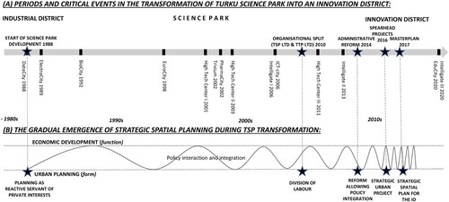
In the 1990s, a major economic recession in the country slowed down the area’s development, but especially in the 2000s, it developed as a concentration of several office buildings, R&D centres and multi-use environments. As indicated by the building names (), they were designed for high-tech companies and especially designated for those in the ICT, biotechnology and pharmaceutical industries. This reflected the cluster-building ideal in organizing the physical environment and contributed to the evolution of high-tech clusters in the TSP area, according to the city strategy. The dedicated buildings were next to each other and they were increasingly also used by higher education institutions.
Related to the industrial cluster-based organization of functions, a major challenge was the area’s fragmented ownership amongst competing private construction companies of whom none would promote a coordinated whole. Furthermore, oversized plots and efficiency levels were remnants of the industrial era, unfit for office building. Until the 2000s, the area developed through isolated private projects, but ‘[e]ven the real estate owners were dissatisfied because there were too many owners […] and no one had a comprehensive development interest’ (Interviewee #2). However, the city started to form the outlook that space should be reserved for the development of a knowledge hub, prohibiting the private construction companies’ large-scale housing plans which would have prevented inter alia the later development of the extended campus and hospital areas. As the area’s strategic significance was increasingly understood, the city started to take a more proactive role in its development. TSP as a technology centre was established in 2001, after arrangements were first made by the city in 1999 to manage and organize production facilities for bio-companies as Turku Bio Valley Ltd (Höyssä, Bruun, and Hukkinen Citation2004, 772; Interviewee #2).
An important event in 2010 was the establishment of two new largely publicly owned companies, Turku Science Park Ltd and Turku Technology Properties Ltd, with a clear yet coordinated division of labour and visionary leadership. The former took responsibility for the functional development of the area, focusing on the strengthening of the innovation ecosystem in the region. The latter focused on developing the premises of the TSP area strategically and holistically and made significant investments, which had not been possible under the earlier ownership structure. It also engaged in resolving issues specific to the real estate business, such as building life cycles and redevelopment, and put effort into developing the brand of the area as an innovative and efficient environment for high technology companies at the core of a dynamically developing business region. The unbundling of real estate and regional economic development – that is, the separation of form and function – was a new start and an important step for the ensuing efficient development of the area, as both companies were now formally able to focus on their core businesses yet also collaborate in their activities.
Still in the 2000s and early 2010s, at the time of another economic recession following the global financial crisis, Turku was not seen nationally as an attractive location for businesses. The area was considered stagnant with an outdated real-estate sector. This situation was later reversed by major investments in the region, boosting its attractiveness. A restructuring of the regional economy in the 2010s started a new phase in the development of the TSP, as the area was portrayed for the first time as an engine for the development of the city and the surrounding region. The gradually converging visions for the area’s development led to deepening collaboration among the anchor institutions, and finally to the development of the Turku Science Park Masterplan 2050 vision, presented by the City of Turku in December 2017. The first strategic vision for comprehensive urban development of the TSP area, the plan marked the beginning of its development as an ID ().
The city’s urban planning and economic development personnel surveyed international trends (interviewee #1, interviewee #6) but the development process of the TSP area did not involve direct adoption of any foreign models. It took an explicitly bottom-up and participatory approach, which was important partly because the resources of a wide pool of public and private actors were needed to realize the ambitious vision. Yet, the process corresponds to international trends of promoting innovation-led urban and regional development, including most recently the creation of IDs. The TSP aims to develop mixed-use environments combining living, working and leisure (City of Turku Citation2017). ‘Urban planning and its significance in this case is enormous. […] everything needed in everyday life must be found in the science park area’ (Interviewee #2). During the process, the role of urban planning changed remarkably from being a reactive servant of private interests to a proactive enabler of comprehensive urban development. Planning became more strategic and integrated diverse actors and sectors in envisioning and promoting the city. ‘Kupittaa started as an individual construction project, but it has become so great that now it is a prime engine for the whole city of Turku’ (interviewee #3).
4.2. Integrated vision for an innovation district
The city’s new proactive role in the 2010s marked a new era in the TSP area development. The key change in urban strategizing was the merging of numerous strategic programmes into a comprehensive strategy in 2013-2014. This was part of a broader administrative reform in the early 2010s that involved also structural changes in the city organization including the establishment of an urban development group cross-cutting sector-based administration. The change was reflected in development rhetoric: having been an enabler of development, the city now presented itself as an activator. Through the reform, the city was able to clarify plans and efficiently allocate resources to desired aims. This resulted in the launch of the city’s two spearhead projects in 2016: the development of the city centre and the development of the TSP area. Hereby, the TSP area officially received the status of a strategic urban project.
In the Science Park area spearhead project, the idea was to pursue comprehensive urban development that would encompass a dialogue between functionality and structure […] . The goal is a common longer-term vision. (Interviewee #7)
For the first time, the creation of the vision for future development in the TSP brought together a range of stakeholder groups to work on a common strategy. Key companies, universities, the university of applied sciences, and public bodies participated in the preparation of the masterplan during 2012–2017. Also citizens could participate and co-create solutions for the TSP through a novel interactive platform, the ‘Turku Future Forum’. Participants in the process formed a common aim to develop a strategic framing and long-term vision for the TSP.
Beginning with the city management, the mindset changed. Perhaps, in urban planning, it had to do with the concept-based thinking of which increasing experiences were also accumulating globally, providing advice as to the management and leadership of those projects, and resourcing them. (Interviewee #10)
The vision was deemed important because it provided guidelines for development and clarified the goals for all parties involved. The horizon was set for 2050, comprising short-, mid- and long-term targets. The long-term vision leaves room for manoeuvring during detailed planning. The general mandate for the realization of the vision was gained through the master planning process and its participatory planning arenas, and the practical execution of the vision is eventually resolved at the level of detailed planning, subject to statutory plans.
The masterplan envisions the TSP as an increasingly significant location of high-technology industries with a brand as an attractive and innovative environment for companies of all sizes requiring modern facilities. It is supposed to attract talented workers by an inspiring and versatile neighbourhood offering all the basic services. Developing the area as a knowledge hub shifts the focus from mere buildings, physical environments, blueprints and infrastructure plans to functionality (Interviewee #1). The branding already begun in Turku Technology Properties after the independent organization was created in 2010 and TSP as an area needed a sharper image for international investors. The earlier branding materials were later used in designing the spearhead project, creating the masterplan and building a unified brand for the previously incoherent area.
The masterplan advocates comprehensive spatial planning for the Kupittaa-Itäharju area. The attempt to pursue a lively district with mixed land use and some round-the-clock functions included daily services (e.g. groceries), cafés, marketing agencies and law firms, as well as public facilities, such as parks, new boulevards, a sports campus, an international school and a new campus for the Turku University of Applied Sciences, completed in 2020. A challenge persists to find a new profile for the area beyond a business district that closes after office hours. This challenge is due to the longstanding spatial division of labour between the Kupittaa-Itäharju working and residential area, and the city centre’s commercial service and leisure area, creating a mental barrier. Additionally, a physical barrier, a highway, cuts Itäharju from Kupittaa and the city centre. The future vision aims at merging the areas through infrastructure investments, by tunnelling the highway, and transit orientation (Turku Science Park Citation2022). The role of urban planning grows substantially during the process, as it is recognized that the area cannot succeed as an isolated science park. It needs an urban structure supporting everyday life.
The large and ambitious vision for the area is expected to attract domestic and foreign investors. Besides private funding, public funding will serve as market validator, showing that local actors are putting major effort into development of the area. According to the vision, Kupittaa will serve as a key transport hub, contributing to the national government’s agenda for rapid train connections between major cities and multimodal transportation. A significant plan is the one-hour train connection between the Turku and Helsinki regions creating one commuting area, with Kupittaa as a vital station en route. New urban public transport hubs would smoothly connect the TSP area to the rest of the city, including a new covered structure above the highway, linking Kupittaa and Itäharju and supporting walkability throughout the ID. Besides additional office space, more housing will be built in the whole area which purports to pursue overall sustainable urban development principles (Turku Science Park Citation2022). This represents agreement-based collaboration with the state in integrated planning.
5. Discussion: innovation districts as strategic urban projects
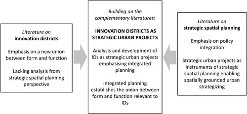
Our study contributes to emerging research on IDs by showing how adding the thus far overlooked perspective of strategic spatial planning helps underscore integrated planning, which is necessary to realize the union between form and function relevant to IDs (Katz and Wagner Citation2014, 6). Conceptualizing IDs as strategic urban projects reveals the need for an integrated strategic spatial planning approach. summarizes the conceptual contribution of the paper that requires bridging the detached literatures on IDs emphasizing the new union between form and function, and strategic spatial planning emphasizing integrated planning.
Figure 2. Analysing and developing IDs as manifestations of the new union between form and function can be advanced by conceptualizing them as strategic urban projects.
Our theoretical argument is supported by an analysis of the development process of the ID in Turku, tracing the evolution of strategic planning in the area. The process of creating the 2017 strategic masterplan for the TSP was transformative activity (cf. Albrechts Citation2010) and a turning point in the area’s development, as it for the first time integrated a wide array of actors from various policy sectors and levels as well as citizen groups and other stakeholders (Albrechts Citation2006) to work on a common strategy. The change in the planning approach did not happen overnight: the premises for policy integration, both horizontally and vertically, were built step by step in formal and informal occasions and dialogues contributing to the development of the area. Hence, those premises are rooted in long-term relationship-building and development of practices for policy integration (cf. Van Assche and Djanibekov Citation2012, 179), making integration a path-dependent process. The area’s transformation was supported by agreement-based policy-making with the national government, concerning integrated planning and growth objectives, and the leadership of several visionary individuals in different decades. In the 2010s, the leadership of TSP development became increasingly shared. This was enabled by well-functioning forums for collaborative governance and decision-making. Altogether, collective understanding of, and commitment to, the chosen development path was enabled by broad participation. Also, the administrative reform in the city in the early 2010s was significant, as it clarified the city’s strategic objectives and cultivated spatially literate leadership of urban development (cf. Sotarauta, Beer, and Gibney Citation2017) through strategic urban projects and new administrative positions explicitly responsible for urban strategizing and development.
In promoting urban innovation by means of strategic spatial planning, the new masterplan for the ID added a clear spatial dimension to the area’s planning which had formerly relied on cluster-based economic development ideas, with hardly any attention having been paid to the physical form of the immediate operating environment. The new strategy for the area’s development crucially comprises the spatial facilitation of relations between clusters in the ID, as well as their interactions with agents elsewhere in the city and beyond. An integrated, comprehensive approach to strategic planning thus potentially helps unite various sector and stakeholder goals under a common planning agenda.
One of the key factors behind the shared understanding and the model for collaborative growth has been the active dialogue between key stakeholders. The European multi-stakeholder ID model identified by Katz and Wagner (Citation2014, 2019) is relevant in understanding the Turku case, as it involves the European strategic spatial planning practice of uniting a range of stakeholders (e.g. Nadin et al. Citation2021), including national governments (cf. Pagliarin, Hersperger, and Rihoux Citation2020), which is in contrast to the developer-led planning culture in the US. However, partnership with the state has also brought volatility to ID development as changing political climate can affect the development of the expensive rapid Helsinki rail connection assumed in the masterplan. The multi-stakeholder model also formed the basis of the renewed TSP brand that was harnessed to improve the attractiveness and competitiveness of the whole region. Hence place-branding was used as an instrument of comprehensive strategic spatial planning (Oliveira Citation2015), constant development of the area constituting a key element of the dynamic brand.
The TSP Masterplan 2050 provides an interesting case for considering the legitimization of the objectives of strategic urban projects (see Mäntysalo, Kangasoja, and Kanninen Citation2015). On the one hand, legitimacy for master planning was sought through crowdsourcing planning via Turku Future Forums, which provided a flexible option for statutory participation processes. This vision-building process functioned as a ‘coproductive trading zone’ (Kalliomäki Citation2015) for various actors to express their views without being caught in the power struggles often characterizing statutory participation (e.g. Balducci and Mäntysalo Citation2013). On the other hand, the process was heavily guided by the strategic rationality pushing for discussions on the efficient ways to realize the city’s strategic intents, hence leaving little room for disagreement in practice (Granqvist et al. Citation2021, 12). Furthermore, the legitimacy of several ideas envisioned in the masterplan additionally required official procedures in the city council and via statutory planning processes. Thus, a gap between statutory and strategic planning processes (Mäntysalo, Kangasoja, and Kanninen Citation2015) also exists in the case of the TSP. Even though interests have been coordinated and combined while preparing the visionary masterplan, practical solutions have to be made at the detailed planning level, and the different sectors of the city administration still have to assume ownership of the vision.
As the role of planning is changing in relation to promoting innovation activities, the city also has had to build new competencies in managing the change. The unbundling of real estate and urban economic development efforts into separate organizations in Turku enabled the creation of comprehensive development interests regarding the physical environment, which somewhat paradoxically boosted the integration of planning (giving form) and development (supporting function).
Altogether, the new union between form and function was made possible by organizational measures that clarified the core tasks and enabled a clear division of labour between the key actors. It was also facilitated by a larger organizational renewal concerning the city’s more efficient strategic management and cross-sectoral coordination (cf. Granqvist et al. Citation2021). These steps in the path of ID creation paved the way for upgrading of the area’s status to strategic urban project, and adaptation of strategic spatial planning approach in the first ever Masterplan. Hence, both individual and collective competencies for strategic spatial planning and related policy integration were being built in the long-term multi-stakeholder dialogues contributing to the area’s development.
6. Conclusions
IDs are increasingly visible in urban landscapes globally. This article contributes by showing how analysing and developing IDs as manifestations of the new union between form and function can be advanced by conceptualizing them as strategic urban projects. Strategic urban projects necessitate spatially grounded urban strategizing and emphasize an integrated development approach. The literature on IDs has so far lacked thorough analyses of strategic spatial planning processes. Explanation of the facilitation of urban innovation requires an understanding of the increasingly integrated planning and development spheres inherent in the strategic spatial planning perspective.
Our case study of the emergence of strategic spatial planning in the context of ID development in Turku depicts the transformation of the Turku Science Park area into an ID through gaining the status of a strategic urban project, as well as the associated fundamental shift in planning and leadership. We argue that this shift played a crucial role in the area’s development towards an ID and thus in the attempts to create preconditions for innovation by crossing governmental silos and scales, uniting actors to work on a common goal. During the process, planning has become more strategic and a proactive activator of comprehensive urban development. By analysing the long-term process of ID development, we shed light on an important change in the planning process, so far relatively absent from the literature on IDs and the analysis of their collaborative governance. As a policy implication arising from the case study we also demonstrate that ID development required abandoning insulated sectoral silos and moving towards increased cross-sectoral coordination within urban management. This was supported by the instrument of strategic urban project, accompanied by a strategic spatial planning approach in ID creation.
It is a current trend to plant IDs in different institutional contexts through international policy mobility and associated learning processes. Our findings concerning the long-term emergence of collaborative processes and the rootedness of the strategic framing of IDs in various organizational cultures and practices of sectoral integration offer important lessons for both ID research and policymaking. The policy mobility processes often criticized for being top-down attempts to promote economic competitiveness (e.g. Lederman & Whitney Citation2022) need to leave room for bottom-up engagement and contextualization. As a result of the growing trend to think spatially about urban development and to recognize the role of the quality of places for economic competitiveness, the trend to strategize planning can be found in diverse parts of the world (see Healey Citation2006). This trend, however, arises from different premises in different cities.
The TSP case demonstrates the change in urban planning, where it is both gaining in importance as a strategic, comprehensive tool for urban development and being instrumentalized for serving economic development interests. Yet, it is important to understand that the process resulting in the comprehensive development of what in our interpretation is currently rapidly transforming into an representative ID, albeit with contextual characteristics, necessitated a decades-long process of gradual mutual learning and increasingly intensifying multi-stakeholder interaction. The process included learning through trial and error and resulted in competence building for urban strategizing. This rootedness of joint strategic frames and social structures behind the collaborative governance scene should not be underestimated in the current attempts to promote international policy mobility and policy learning.
Turku is one of the largest urban centres in a small country with a fairly homogenous and well-educated population. Strategy implementation is ongoing and invites further research. As strategic spatial planning is typically associated with relatively well-off cities and regions, further research on contextual factors is also needed to draw lessons, for example, for structurally weak regions seeking urban transformation. Cities developing IDs around the world may struggle with severe societal inequalities and are challenged in their attempts to legitimize concentrations of high tech innovation in central districts (cf. Gómez and Oinas Citation2022). In cities with highly inequal urban structures, broadly based participatory and transparent strategic planning procedures gain an even higher urgency, to enable adjusting the concept to the needs of diverse societal groups (Wolff-Powers Citation2022). Locally sensitive place leadership, cross-sectoral coordination and multi-level governance procedures may help support transformative strategy processes even in cities ridden by socioeconomic challenges, requiring new kind of competencies in managing urban transformation.
In future development of IDs, the changing – and more strategic – roles of urban planning and development pose challenges for contemporary planning systems and land use policy. We contend that promoting IDs as strategic urban projects necessitates a fundamental shift in planning. This phenomenon requires further analysis in the forthcoming research on IDs, for example, from the perspectives of competence building in horizontal coordination and shared leadership that need to be operationalized via diverse scalar and sectoral practices of the city organization as well as diverse collaborative governance networks. Strategic spatial planning for urban innovation challenges contemporary planning structures, which are already balancing between statutory and informal processes. Hence, future research needs to scrutinize the competencies of cities in promoting urban innovation in environments characterized by increased sectoral and scalar integration.
Disclosure statement
No potential conflict of interest was reported by the author(s).
Additional information
Funding
References
- Adu-McVie, R., T. Yigitcanlar, I. Erol, and B. Xia. 2021. “Classifying Innovation Districts: Delphi Validation of a Multidimensional Framework.” Land Use Policy 111: 105779. doi:10.1016/j.landusepol.2021.105779.
- Albrechts, L. 2006. “Bridge the Gap: From Spatial Planning to Strategic Projects.” European Planning Studies 14 (10): 1487–1500. doi:10.1080/09654310600852464.
- Albrechts, L. 2010. “More of the Same is not Enough! How Could Strategic Spatial Planning be Instrumental in Dealing with the Challenges Ahead?” Environment and Planning B: Planning and Design 37: 1115–1127. doi:10.1068/b36068.
- Albrechts, L. 2015. “Ingredients for a More Radical Strategic Spatial Planning.” Environment and Planning B: Planning and Design 42: 510–525. doi:10.1068/b130104p.
- Albrechts, L., and A. Balducci. 2013. “Practicing Strategic Planning: In Search of Critical Features to Explain the Strategic Character of Plans.” disP – The Planning Review 49 (3): 16–27. doi:10.1080/02513625.2013.859001.
- Avoindata.fi. 2022. Turun kaupungin pienaluetilastoja [Areal Statistics of the City of Turku]. Accessed 18 March 2022. https://www.avoindata.fi/data/fi/dataset/turun-kaupungin-pienaluetilastoja [in Finnish]
- Ayres, S. 2014. “Place-based Leadership: Reflections on Scale, Agency and Theory.” Regional Studies, Regional Science 1 (1): 21–24. doi:10.1080/21681376.2013.869424.
- Baily, M., and N. Montalbano. 2018. Clusters and Innovation Districts: Lessons from the United States Experience. The Brookings Institution, Economic Studies. Accessed 15 June 2020. https://www.brookings.edu/wp-content/uploads/2018/05/es_20180508_bailyclustersandinnovation.pdf
- Balducci, A., and R. Mäntysalo, Eds. 2013. Urban Planning as a Trading Zone. Dordrecht: Springer.
- Battaglia, A., and D. Tremblay. 2011. “22@ and the Innovation District in Barcelona and Montreal: A Process of Clustering Development Between Urban Regeneration and Economic Competitiveness.” Urban Studies Research, doi:10.1155/2011/568159.
- Block, T., K. Steyvers, S. Oosterlynck, H. Reynaert, and F. De Rynck. 2012. “When Strategic Plans Fail to Lead. A Complexity Acknowledging Perspective on Decision-Making in Urban Development Projects – The Case of Kortrijk (Belgium).” European Planning Studies 20 (6): 981–997. doi:10.1080/09654313.2012.673561.
- Cameron, J., N. Odendaal, and A. Todes. 2004. “Integrated Area Development Projects: Working Towards Innovation and Sustainability.” Urban Forum 15 (4): 311–339. doi:10.1007/s12132-004-0012-6.
- City of Turku. 2017. “Turku Science Park Masterplan 2050.” Presenting the Future Image of Turku Science Park (pdf). Accessed 27 November 2018. https://www.turuntiedepuisto.fi/en/turku-science-park-spearhead-project
- City of Turku. 2021. Turku Science Park Spearhead Project. Accessed 5 August 2021. https://www.turuntiedepuisto.fi/en/turku-science-park-spearhead-project
- City of Turku. 2022. Turun Tiedepuisto – Turku Science Park. Accessed 14 March 2022. https://www.turku.fi/en/turun-tiedepuisto-turku-science-park
- Duvivier, C., M. Polèse, and P. Apparicio. 2018. “The Location of Information Technology-led New Economy Jobs in Cities: Office Parks or Cool Neighbourhoods?” Regional Studies 52 (6): 756–767. doi:10.1080/00343404.2017.1322686.
- Esmaeilpoorarabi, N., T. Yigitcanlar, and M. Guaralda. 2018a. “Place Quality in Innovation Clusters: An Empirical Analysis of Global Best Practices from Singapore, Helsinki, New York, and Sydney.” Cities 74: 156–168. doi:10.1016/j.cities.2017.11.017.
- Esmaeilpoorarabi, N., T. Yigitcanlar, M. Guaralda, and Md. Kamruzzaman. 2018b. “Evaluating Place Quality in Innovation Districts: A Delphic Hierarchy Process Approach.” Land Use Policy 76: 471–486. doi:10.1016/j.landusepol.2018.02.027.
- Esmaeilpoorarabi, N., T. Yigitcanlar, Md. Kamruzzaman, and M. Guaralda. 2020. “Conceptual Frameworks of Innovation District Place Quality: An Opinion Paper.” Land Use Policy 90: 104166. doi:10.1016/j.landusepol.2019.104166.
- Gómez, L., and P. Oinas. 2022. “Traveling Planning Concepts Revisited: How They Land and why it Matters.” Urban Geography, doi:10.1080/02723638.2022.2127267.
- Granqvist, K., H. Mattila, R. Mäntysalo, A. Hirvensalo, S. Teerikangas, and H. Kalliomäki. 2021. “Multiple Dimensions of Strategic Spatial Planning: Local Authorities Navigating Between Rationalities in Competitive and Collaborative Settings.” Planning Theory & Practice 22 (2): 173–190. doi:10.1080/14649357.2021.1904148.
- Healey, P. 1997. “The Revival of Strategic Spatial Planning in Europe.” In Making Strategic Spatial Plans, edited by P. Healey, A. Khakee, A. Motte, and B. Needham, 3–19. London: U.C.L. Press.
- Healey, P. 2006. Collaborative Planning. Shaping Places in Fragmented Societies. Basingstoke: Palgrave Macmillan.
- Hersperger, A., E. Oliveira, S. Pagliarin, G. Palka, P. Verburg, J. Bolliger, and S. Grădinaru. 2018. “Urban Land-use Change: The Role of Strategic Spatial Planning.” Global Environmental Change 51: 32–42. doi:10.1016/j.gloenvcha.2018.05.001.
- Höyssä, M., H. Bruun, and J. Hukkinen. 2004. “The co-Evolution of Social and Physical Infrastructure for Biotechnology Innovation in Turku, Finland.” Research Policy 33: 769–785. doi:10.1016/j.respol.2003.12.003.
- Kalliomäki, H. 2015. “Reframing Strategic Spatial Planning as a Trading Zone Between State-led and Place-Based Interests: Reflections from Maryland and Finland.” Land Use Policy 42: 113–123. doi:10.1016/j.landusepol.2014.07.008.
- Katz, B., and J. Wagner. 2014, May. The Rise of Innovation Districts: A new Geography of Innovation in America. Brookings: Metropolitan Policy Program. https://www.brookings.edu
- Lederman, J., and R. A. Whitney. 2022. “What is Progressive City Building? Global Expertise and Local Entanglements in Latin America.” Urban Geography. doi:10.1080/02723638.2022.2125668.
- Lundén, J. 2017. 50 Vuotta Turkua Rakentamassa [50 Years of Building Turku]. Turku: Juhani Lundén. [in Finnish].
- Massey, D., and D. Wield. 1992. High-Tech Fantasies. Science Parks in Society, Science and Space. London: Routledge.
- Mäntysalo, R., J. Kangasoja, and V. Kanninen. 2015. “The Paradox of Strategic Spatial Planning: A Theoretical Outline with a View on Finland.” Planning Theory & Practice 16 (2): 169–183. doi:10.1080/14649357.2015.1016548.
- Mäntysalo, R., and V. Kanninen. 2018. “Kaupunkiseutujen Integroiva Suunnittelu ja Hallinta [Integrated Planning and Governance in City Regions].” Yhdyskuntasuunnittelu 3 (56), [in Finnish].
- Ministry of the Environment. 2023. Land Use, Housing and Transport Agreements. Retrieved 2 March 2023. https://ym.fi/en/agreements-on-land-use-housing-and-transport
- Morawska, I., K. Anielska, J. Gądecki, and Ł Afeltowicz. 2021. “Changes in Urban Fabric – a Cause or a Result of an Innovation District?” Journal of Urbanism: International Research on Placemaking and Urban Sustainability, doi:10.1080/17549175.2021.2005118.
- Moultrie, J., M. Nilsson, M. Dissel, U. Haner, S. Janssen, and R. Van der Lugt. 2007. “Innovation Spaces: Towards a Framework for Understanding the Role of the Physical Environment in Innovation.” Creativity and Innovation Management 16 (1): 53–65. doi:10.1111/j.1467-8691.2007.00419.x.
- Nadin, V. 2007. “The Emergence of the Spatial Planning Approach in England.” Planning Practice and Research 22 (1): 43–62. doi:10.1080/02697450701455934.
- Nadin, V., D. Stead, M. Dąbrowski, and A. Fernandez-Maldonado. 2021. “Integrated, Adaptive and Participatory Spatial Planning: Trends Across Europe.” Regional Studies 55 (5): 791–803. doi:10.1080/00343404.2020.1817363.
- Oliveira, E. 2015. “Place Branding as a Strategic Spatial Planning Instrument.” Place Branding and Public Diplomacy 11 (1): 18–33. doi:10.1057/pb.2014.12.
- Oosterlynck, S., L. Albrechts, and J. Van den Broeck. 2011. “Strategic Spatial Planning Through Strategic Projects.” In Strategic Spatial Projects. Catalysts for Change, edited by S. Oosterlynck, J. Van den Broeck, L. Albrechts, F. Moulaert, and A. Verhetsel, 1–14. London: Routledge.
- Pagliarin, S., A. Hersperger, and B. Rihoux. 2020. “Implementation Pathways of Large-Scale Urban Development Projects (lsUDPs) in Western Europe: A Qualitative Comparative Analysis (QCA).” European Planning Studies 28 (6): 1242–1263. doi:10.1080/09654313.2019.1681942.
- Pancholi, S., T. Yigitcanlar, and M. Guaralda. 2018. “Societal Integration That Matters: Place Making Experience of Macquarie Park Innovation District, Sydney.” City, Culture and Society 13: 13–21. doi:10.1016/j.ccs.2017.09.004.
- Sotarauta, M., A. Beer, and J. Gibney. 2017. “Making Sense of Leadership in Urban and Regional Development.” Regional Studies 51 (2): 187–193. doi:10.1080/00343404.2016.1267340.
- Stead, D., and E. Meijers. 2009. “Spatial Planning and Policy Integration: Concepts, Facilitators and Inhibitors.” Planning Theory & Practice 10 (3): 317–332. doi:10.1080/14649350903229752.
- Turku Business Region. 2019. Turku Business Region. Accessed 17 October 2019. https://turkubusinessregion.com/en/
- Turku Science Park. 2022. Turku Partnership Project. Accessed 5 December 2022. https://www.turuntiedepuisto.fi/en/kupittaa-partnership-project
- Turku Technology Properties. 2022a. Key Figures. Accessed 14 March 2022. https://www.teknolog iakiinteistot.fi/en/company/key-figures
- Turku Technology Properties. 2022b. From the Textile Industry to Technology Companies. Accessed 23 December 2022. https://www.teknologiakiinteistot.fi/en/science-park/history
- Van Assche, K., and N. Djanibekov. 2012. “Spatial Planning as Policy Integration: The Need for an Evolutionary Perspective. Lessons from Uzbekistan.” Land Use Policy 29: 179–186. doi:10.1016/j.landusepol.2011.06.004.
- Wagner, J., B. Katz, and T. Osha. 2019. The Evolution of Innovation Districts. The New Geography of Global Innovation. The Global Institute on Innovation Districts. Accessed 7 June 2019. https://www.giid.org/the-evolution-of-innovation-districts/#subscribe-for-download-file
- Wolff-Powers, L. 2022. University City. History, Race, and Community in the era of the Innovation District. Philadelphia: Pennsylvania University Press.
- Yigitcanlar, T., R. Adu-McVie, and I. Erol. 2020. “How Can Contemporary Innovation Districts be Classified? A Systematic Review of the Literature.” Land Use Policy 95: 104595. doi:10.1016/j.landusepol.2020.104595.
- Yigitcanlar, T., and T. Inkinen. 2019. Geographies of Disruption: Place Making for Innovation in the Age of Knowledge Economy. Cham: Springer.
- Yigitcanlar, T., and S. Teriman. 2015. “Rethinking Sustainable Urban Development: Towards an Integrated Planning and Development Process.” International Journal of Environmental Science and Technology 12: 341–352. doi:10.1007/s13762-013-0491-x.
- Ziafati Bafarasat, A. 2015. “Reflections on the Three Schools of Thought on Strategic Spatial Planning.” Journal of Planning Literature 30 (2): 132–148. doi:10.1177/0885412214562428.
- Ziafati Bafarasat, A., and E. Oliveira. 2021. “Disentangling Three Decades of Strategic Spatial Planning in England Through Participation, Project Promotion and Policy Integration.” European Planning Studies 29 (8): 1375–1392. doi:10.1080/09654313.2020.1863920.
- Zukin, S. 2020. The Innovation Complex. Cities, Tech and the new Economy. Oxford: Oxford University Press.