
Introduction
A geographic information system (GIS) can be defined as a computer-based system that enables the collection, management, analysis, visualization, and sharing of spatial data. As this technology is a fundamental and fast-growing part of the global economy (Gilbert and Krygier Citation2007), there is a growing global demand for a skilled workforce that can use it to address an array of spatial issues (Richardson Citation2009). GIS is taught in some higher education courses, primarily geography, which enhances students’ employment opportunities. However, while there is potential to embed GIS as a commonplace tool in schools, doing so has been a perennial challenge, with an array of obstacles to overcome, and support for those “intrepid souls” (DeMers Citation2016, 23) who pioneer GIS use in schools is needed. Universities may have a part to play in this.
The Use of GIS in Schools
A wide range of strategies has been deployed to develop GIS skills and experience in schools. These include preservice or in-service training for teachers or university–school collaboration (Wang and Chen Citation2013), enhancing GIS skills in universities (Manson et al. Citation2014), connecting school pupils with the GIS industry (Healy and Walshe Citation2020), and developing school GIS courses (Nielsen, Oberle, and Sugumaran Citation2011). While some approaches concentrate on one strategy, most favor a range of complementary strategies which, in combination, may more easily overcome some of the obstacles.
Despite these initiatives, and while earlier obstacles such as access to GIS software and data have been resolved or significantly reduced, teachers still face a number of barriers to uptake. These include a lack of reusable learning objects (RLOs) that are ready to use in lessons (Hong Citation2014) and a lack of support for teaching GIS lessons in classrooms (Baker, Palmer, and Kerski Citation2009). West (Citation2006) also warned that the time lag between training and teaching with GIS can lead to loss of enthusiasm and skills. Short class times, which limit sustained engagement, can be another barrier (Höhnle et al. Citation2016).
Numerous studies have highlighted the critical link between GIS experts and schools, with universities or software providers preparing lessons and data that can be used directly in classrooms. Hong (Citation2014) collaborated with teachers through user-centered design to create tailored GIS lessons with 30 teachers in Colorado. While the study identified challenges, it highlighted the benefit of lessons that are tailored to specific teacher needs and skills. To make GIS sustainable, Dascombe (Citation2006) called for trained GIS experts who can prepare and deliver GIS lessons for use in classrooms.
Many studies (Healey, Flint, and Harrington Citation2014; Mitchell et al. Citation2018) emphasize the need for communities of practice between university staff and students with students becoming active partners in the learning. University–school collaboration supporting the uptake of GIS in schools is likely to produce reciprocal benefits, with both school pupils and university students developing and enhancing their skills (Nielsen, Oberle, and Sugumaran Citation2011) and, given the scope to help younger learners to see the potential of GIS, ultimately to increase recruitment to geography undergraduate programs.
This paper describes our experience of a multipartner approach whereby GIS students (undergraduates pursuing Geography and Environmental Science degrees who are enrolled for GIS classes), under the guidance of tutors, collaborate with preservice and in-service geography teachers to prepare and deliver GIS activities in classrooms. Based on the authors’ experience, we suggest that this model can produce a win-win-win: for pupils, for students—both GIS and preservice student teachers—and for the promotion and development of GIS in all sectors.
In this paper, for clarity, we will refer to learners at universities as “students” and their teachers as “tutors,” while at the school level, we will use the terms “pupils” and “teachers.”
Developing a Sustainable Strategy
Ulster University’s School of Education and School of Geography and Environmental Sciences have collaborated for over a decade to promote GIS use in schools. Early efforts took the form of workshops and events for pupils and for school teachers, held on the university campus, which were devised and delivered collaboratively by students enrolled in GIS modules, preservice teachers (PST), and tutors from both Schools, combining the GIS students’ knowledge of the technology and its practical implementation with the PST students’ understanding of how to engage high school pupils. While successful, this approach demanded considerable time and input from all involved and was therefore challenging to manage in conjunction with tutors’ and students’ other commitments. In addition, the model of workshop delivery on the university campus incurred significant costs in transporting pupils to and from schools and limited the geographic spread of schools that could be involved to those within easy commuting distance of the campus. We did not feel it would be a sustainable way of encouraging GIS uptake in schools as a long-term strategy.
We therefore revised our approach to focus on students collaborating directly with teachers to develop, and in many cases to deliver, GIS lessons within the school classroom, removing the logistical and financial impediments of campus-based events. To encourage student participation, the assessment in a final-year GIS class was modified to offer a “GIS in schools” option to all members of the class. Each year, these students were introduced to the place of GIS within the Northern Ireland curriculum (Council for the Curriculum, Examinations and Assessment [CCEA] Citation2020), conducted a literature review to identify the main challenges and opportunities of teaching GIS in schools, and reviewed a variety of lessons suitable for use in classrooms. Using contacts with schools established through previous events, or through students’ earlier high school education, each GIS student was allocated to a school to form an educational partnership. The GIS student worked with a teacher in that school to identify a relevant topic and to develop a practical GIS lesson (produced in the form of a GIS manual) suitable for classroom delivery. Since this work was undertaken as part of the class assessment, it did not place an additional burden on students or staff and was therefore a much more sustainable model than the campus-based workshops. Due to requirements of the preservice teaching curriculum, it was not possible to integrate the GIS in schools activity into its assessment scheme, meaning that participation of PST students was more limited; however, some engagement continued in the form of discussion of topics and pedagogical approaches with GIS students during the development of the manual.
As an additional incentive, all students opting to create a GIS manual as their class assessment were encouraged to deliver it to pupils through the university’s volunteering scheme, Tutoring in Schools. This scheme enabled students to gain experience of classroom teaching (32 hours over 12 weeks), with transport costs funded and accreditation provided on completion. Teachers also gained experience with GIS through this classroom teaching, and the GIS manual remained with the teacher to be taught in subsequent years to different cohorts of pupils.
In essence, we believe this a viable and sustainable model for supporting GIS use in schools because (a) teachers recognize the value of introducing GIS even though they often lack the time and experience to do this by themselves and are therefore keen to work with students; (b) students have the necessary knowledge, enthusiasm, and motivation (for example, developing their own technical and communication skills, enhancing their employability and, potentially, gaining additional accreditation); and (c) the collaboration between teacher and GIS student ensures that the exercises developed are relevant and appropriate to the classroom.
Outcomes
During the first three years of our revised approach, we collected information and feedback from students and teachers (via questionnaires and focus groups) to help us evaluate and fine-tune it. During this period, approximately half of the GIS students in each class (an average of 24 per year) opted to create a GIS manual for their module assessment, producing 71 manuals that could potentially be used as teaching resources by high school teachers. During the same period, 45 students delivered their GIS manuals as lessons in classrooms over several weeks via the Tutoring in Schools scheme, in some cases to multiple classes, reaching more than 1,700 pupils in 36 schools (an overall ratio of 1 university student to 38 school pupils). All geography teachers involved gained experience of GIS in the classroom as they observed and worked alongside the GIS students (the ratio of students to teachers was generally one-on-one, although in some cases a student liaised with several teachers in a geography department). Reuse of manuals by many of the teachers in subsequent years means that the numbers of pupils taught increases without additional student input.
GIS manuals addressed topics such as crime mapping, flooding, site selection, tectonics, service mapping, routing, and migration. Tutors encouraged students to use web-based systems such as ArcGIS Online and Google Earth to avoid software and hardware issues within schools, although in some cases it was possible for them to use desktop GIS. The majority of teachers rated the student manuals as “well prepared with evidence of a great deal of student effort”; however, some felt that the students initially pitched GIS activities above the pupils’ capabilities and had recommended a more gradual introduction to GIS. Teachers have found that lessons are well received by pupils but are heavily constrained by time. As such, some teachers have spread GIS over multiple lessons and sometimes included it as homework, which is facilitated by the use of web-based GIS.
Examples of Classroom Interventions
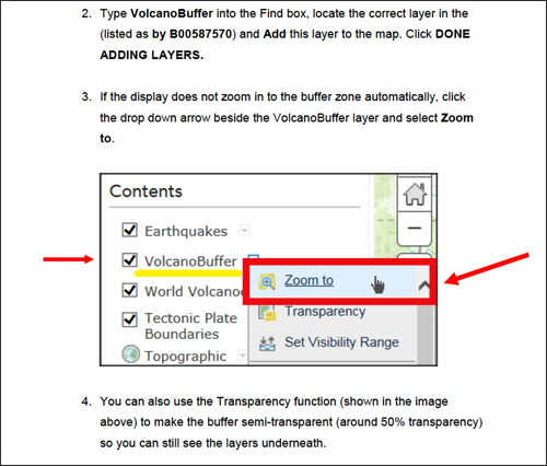
Landforms and landscapes: This manual and teaching opportunity used ArcGIS Online to examine landforms and landscapes, as required in the Leaving Certificate Geography curriculum in the Republic of Ireland, where this student completed her Tutoring in Schools. (The geography curriculum in the UK and Ireland includes meteorology and earth sciences covered in science in some other countries.) The target learners were 16- to 17-year-olds. The student created “how-to” videos and included video links within the manual to provide support for stages such as changing layer properties (https://www.youtube.com/watch?v=roH_kkZkIUE) and adding buffers (https://www.youtube.com/watch?v=cGrH3AxzrK8). Screenshots were used to good effect to guide the learners through the various features of the program and through the steps to add layers within ArcGIS Online, create a buffer around a volcano, and count the number of earthquakes within the buffer ().
Figure 1. Step-by-step instructions in the manual.
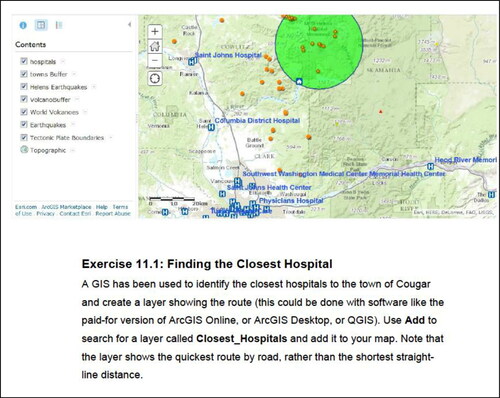
The manual then moved on to identifying centers of population potentially at risk by adding a settlement buffer and, using the measuring feature, the distance from these populated areas to the hazards was displayed. To locate the nearest hospitals, the learners were directed to a layer which the student had created in ArcGIS Desktop and uploaded to ArcGIS Online for use in the lesson (). This exercise, which was entirely novel to these learners, accomplished the learning that was necessary to address the requirements of the geography syllabus but also developed the pupils’ GIS awareness and basic skills. Teacher skills were also enhanced, and this GIS exercise was subsequently repeated by the teacher with other classes.
Figure 2. Adding a student-created layer to ArcGIS Online.
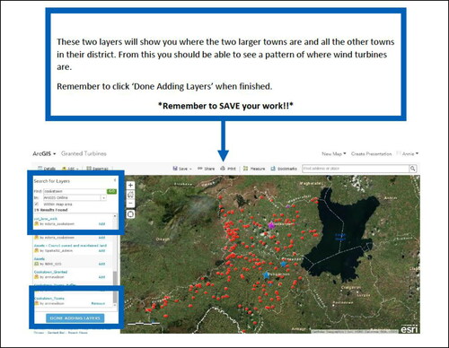
Renewable energy: The second example also used ArcGIS Online, but the focus was on the potential development of wind farms in part of Northern Ireland, designed for 11- to 14-year-old learners. After some preliminary exercises to develop the pupils’ skills in navigating the program and performing basic operations, the manual directed the learners to layers which the student had created specifically for this exercise. These layers displayed all of the wind turbines in two areas of Northern Ireland. When a settlement layer was added (), the learners were shown how to draw buffers around these, allowing the number of wind turbines in close proximity to centers of population to be calculated. This exercise combined the important topic of renewable energy and the challenges of siting wind turbines to reduce impact on large numbers of people, using GIS to support the analysis. That the example was local to these learners was particularly effective in developing and sustaining interest.
Figure 3. Wind turbines in part of Northern Ireland.
A further list of manuals can be seen here: http://gischools.weebly.com/gis-manuals.html.
Benefits to Teachers
The literature has called for GIS lessons that are locally relevant (Beeson Citation2006), relevant to the curriculum through teacher collaboration (Hong Citation2014), and clearly illustrated to minimize preparation time (DeMers and Vincent Citation2008). In the main, GIS students, working alongside practicing teachers and with some input from PSTs, produced lessons that satisfied each of these criteria. Equipping teachers with GIS lessons has subsequently led to pupils being taught GIS in the classroom over multiple years, bringing advantages of continuity and development of spatial learning.
Teachers also enjoyed the opportunity to learn new skills in collaboration with both students and tutors from the university. One teacher reported:
I did a version of the geography of crime with our Year 10s which they loved! It was great as a teacher to gain “an education” into current geography. Often we get bogged down in specifications and exams and don’t get the time or have the expertise to further our professional development in the delivery of the subject (Teacher A).
Some teachers testified to GIS students interacting with school IT support teams to install required software on school networks. On several occasions, GIS students were able to fix small technical problems that would have created difficulties for teachers with little knowledge or experience in GIS.
The process also supported teacher skill development, often incidentally.
The work produced by [the student] was outstanding, innovative, and relevant to the needs of the curriculum and the pupils in our school. [The student] was professional [and] hardworking and listened to our needs at all times. As a result we have a few very innovative lessons that will be interesting and enjoyable for both staff [teachers] and students [pupils] (Teacher B).
Teachers were also keen to use GIS to highlight potential careers that would be available to pupils studying geography while enhancing the profile of the subject within schools. In many cases, they also used the visiting students as positive role models for pupils.
Benefits to Students
Thematic analysis of student feedback was conducted to identify the main factors that led students to engage with teaching GIS. From this analysis, three main themes were identified: First, by teaching GIS to others, students developed their own knowledge and skills. Second, students were interested in GIS and were keen to share their enthusiasm for it with others. Third, students wanted to gain experience in teaching to enhance their employability profile.
Students often found that school pupils became engaged with GIS activities beyond the main exercise, enquiring about further functionality. As a consequence of being asked questions by pupils, students demonstrated new GIS skills to pupils. This suggests that collaboration between students and pupils is mutually beneficial, developing spatial thinking in both groups of learners.
One of the pupils was doing really well with the project so I decided to show her how to do something more difficult with the software. She was having trouble with completing it at the start but I left her to work it out and she was so excited when she got it to work, she shouted out! It was good to see that she was enjoying it that much! (GIS student)
GIS students moved from passive to active users of GIS as a result of pupil and teacher interaction. Students highlighted the value of teaching GIS for their employability, often building their confidence in the use of GIS and encouraging them to pursue a career in the GI industry. Many showcased their experience during initial teacher education (ITE) interviews, which demonstrated their classroom experience and knowledge in the application of GIS. As these students become in-service teachers, they should exhibit more developed pedagogical content knowledge and strong technical expertise (Dascombe Citation2006; Baker, Palmer, and Kerski Citation2009).
GIS students found it challenging to dedicate sufficient time for a voluntary program during their program of study. However, with students concerned about enhancing their skills for employability, they invariably invested the time required. The GIS students obtained additional professional credits and a certificate in recognition of the teaching that they had completed. PST students were better prepared for delivering GIS and for discussing this in interviews for teaching positions. The PST students were also provided with GIS manuals that they were able to use or modify for their subsequent teaching of GIS in schools.
Benefits of Cross-Discipline Student Networks
Collaboration between GIS and PST Geography students to create GIS lessons for the on-campus workshops and the GIS manuals highlighted both challenges and opportunities. PST students tend to have high levels of digital competence, but they are not always familiar with GIS—it is possible to complete a geography undergraduate degree in Ireland or the UK without any significant GIS components. The technical skills of GIS students alongside the nascent teaching skills of the PST students complemented each other very effectively, to the benefit of both parties. Overall, the GIS students and student teachers wanted greater collaboration to create and deliver additional GIS lessons. The majority of PST students have also called for more GIS training during their ITE program.
PST students who had previously encountered GIS had mixed views about it, and some initially believed it “too difficult” to be implemented in schools. However, even those skeptics found the engagement with GIS students and pupils and teachers helpful for incorporating GIS into their pedagogic practices, providing innovative ideas as well as access to data and more recent technologies. One noted:
Prior to the [ITE] course I had used GIS in my undergraduate degree and was not at all confident in the use of it in the classroom. Throughout the year my opinion has totally changed (student from preservice teacher geography course).
Challenges and Solutions
Throughout the development of this approach, various challenges were encountered that required students and tutors to develop solutions ().
Table 1. Challenges encountered and suggestions for addressing these.
Hardware and Software
The challenges of hardware and software were evident in most schools. While desktop GIS (e.g., QGIS or ArcGIS) offer tools for spatial analysis, they can be difficult to install on school computers due to insufficient hardware or IT support. The complexity of the software can also be a deterrent to teachers. As a result, students and schools favor the use of web-based GIS packages such as ArcGIS Online that are free to use and simply require an internet connection. In many cases, students used desktop GIS to prepare data and then uploaded it for use in the web-based software. The authors agree with Kerski, Demirci, and Milson (Citation2013, 232) that “open data and web-based map services could cause a significant increase in the numbers of schools, educators, and students teaching and learning with GIS,” and ESRI’s provision of free access to ArcGIS Online for schools may prove decisive in promoting much wider uptake of the technology by teachers.
Lesson Times
Some studies have highlighted the difficulty of teaching GIS within the limited confines of a school timetable (Baker, Palmer, and Kerski Citation2009). During Tutoring in Schools, some schools maintained their traditional lesson timing (35–45 minutes) while others allocated longer blocks of time. The GIS students were able to adapt to both approaches but found blocks of dedicated GIS time more technically straightforward and better for fostering greater spatial enquiry. However, longer blocks with younger children could lead to waning pupil interest, and in some mixed-ability classes, students found pupils unable to focus for 45 minutes and therefore they had to employ different activities to ensure continued engagement.
Subject Focus
GIS in the UK is often considered to be restricted to geography (Dascombe Citation2006), and this means lost opportunities for interdisciplinary activities. However, by placing students in classrooms across multiple disciplines, they can provide expertise and promote the use of GIS in other subjects. Students were occasionally asked to conduct GIS or mapping exercises with subjects such as business studies or history, allowing pupils to experience GIS in other areas of the curriculum. Having a student who can act as a GIS ambassador in a school may encourage cross-curricular adoption of GIS.
The Crucial Role of Teachers in Partnerships
For successful adoption and promotion of the use of GIS within schools, teacher enthusiasm is key. While many teachers may lack GIS skills and knowledge, they are often acutely aware of its potential to enhance pupil learning. In the strategy we have described, students with knowledge and skills in GIS were paired with teachers to facilitate and support the teaching of GIS in classrooms. By forming educational partnerships between GIS students and teachers and pupils, a community of practice was created that provided GIS support to teachers while simultaneously enhancing important skills among students. This approach puts the student at the center of the process and showcases student skills and knowledge while also raising the confidence and ability of teachers to deliver GIS lessons in classrooms. Through this approach, teachers are not only provided with relevant GIS resources but also supported in the delivery of these GIS lessons to pupils. Successful implementation of GIS within classrooms requires enthusiastic teachers to make GIS a sustainable part of classroom life (Wang and Chen Citation2013).
Conclusion
These educational partnerships have meant that teachers become equipped and enabled to teach GIS with no cost and little preparation time, while GIS students gain important employability skills and engage in active and experiential learning. Additionally, they have gained significant skills in sourcing spatial data, operating software, performing analyses, interpreting results, and presenting findings to an audience, all skills that will be useful in whatever direction their careers develop. The GIS manuals are generally edited by teachers for their specific class and the teacher forms a crucial part of quality assurance of the content. This mutually beneficial partnership approach helps to ensure the sustainability of the program (Dascombe Citation2006) and, we believe, has the potential to significantly erode some of the barriers to GIS implementation in schools. Lack of scope for modifying the preservice teaching course structure followed by PST students prevented their participation in the GIS student–teacher partnership, but the benefits observed from earlier collaborations between GIS and PST students would suggest this to be the optimum route to take whenever feasible. The development of skills in GIS, including pedagogic skills, should be a requirement for geography PST, as happens in the institution in this study. However, maximum benefit seems to accrue when a collaboration is fostered between nascent teachers and undergraduates with a passion for GIS, particularly when developed alongside close links with schools. Additionally, while keeping the in-school component of this study voluntary brought some strengths, the potential benefits are such that there may be merit in making this a credit-bearing part of an undergraduate course.
The experience gained through the interaction between academics and teachers via the various initiatives led directly to the development of a master’s-level GIS short course for teachers offered at the university. Both PST students and in-service geography teachers have enrolled in the course to gain additional GIS accreditation and to learn new skills for implementation of GIS. Linking PST students with in-service teachers through the course also has the potential to encourage the development of professional networks within which resources and expertise can be shared.
Practical Steps to Implement Change
Build a community across schools, PST education providers, and local universities combining the skills and expertise of all these partners.
Aim for a collaboration that is sustainable and low or zero cost.
Involve teachers in addition to school pupils to ensure continued development of GIS in school teaching.
Maximize the ratio of university students and PSTs to school pupils to ensure greatest impact.
Emphasize the enhanced employability benefits to university students and to PSTs.
Stress the benefits of increased GIS expertise and more varied opportunities for learning for school teachers and pupils.
Highlight the value of cross-discipline networks within the university, making links and building capacity.
Adapt the timetable in schools, if possible, to allow extended periods for incorporating GIS-rich lessons, ideally combined with a variety of other activities.
Encourage activities in schools that are tailored to the age and experience of the learners in terms of the geographical context, the technical skills, and the length of activity—what works in a primary school will not work in a secondary school, and vice versa.
Additional information
Notes on contributors

Paul McKenzie
Paul McKenzie is a Senior Lecturer in the School of Geography and Environmental Sciences at Ulster University, with degrees in Geography (BSc), teacher training (PGCE Primary), GIS (MSc) and Remote Sensing (PhD). He teaches on several undergraduate and postgraduate modules on the geography and environmental science degree programs and is currently the Academic Lead for Education in the school. Paul is interested in the use of GIS and remote sensing to address a wide range of societal issues, with a particular focus on fuel and food poverty. He also has a keen interest in developing the use of GIS in schools. He was awarded Ulster University’s Distinguished Teaching Fellowship (team award) in 2015 and won the Association of Geographical Information Education Award in 2015 with colleagues in Geography and Education. Paul is a Chartered Geographer (GIS) and a Fellow of the Royal Geographic Society (FRGS).

Sally Cook
Sally Cook has been a Lecturer and Reader in GIS in the School of Geography and Environmental Sciences at Ulster University for more than 20 years, following four years as a postdoctoral researcher in the same School. Her teaching and research interests focus on the science, technology, and application of GIS and geographic methodologies, with emphasis on the use of GIS for spatial and statistical analysis of social, environmental, and health impacts. She has participated in a number of widening access and outreach projects, including encouraging uptake of GIS within secondary education, and has represented higher education on several geographic information industry groups in Northern Ireland. She was awarded Ulster University’s Distinguished Teaching Fellowship (team award) in 2009 and in 2015 and won the Association of Geographical Information Education Award in 2015, together with colleagues in Geography and Education.

Stephen Roulston
Stephen Roulston is a Lecturer in the School of Education at Ulster University and currently Course Director for PGCE Geography. After 20 years teaching, largely Geography and Geology, in a range of schools in Northern Ireland, he was an Educational Consultant in eLearning, joining Ulster University as a Lecturer in 2009. His research interests include digital technologies used in supporting learning and teaching as well as the challenges of education in a divided society emerging from conflict. He is a Senior Fellow of the Higher Education Academy, a Fellow of the Royal Geographical Society and, with colleagues, a recipient of a Distinguished Teaching Team Award from Ulster University, the Digital Earth GIS Centre of Excellence award and winner of the Association of Geographical Information Education Award in 2015. He serves as Northern Ireland representative on the International Geographical Union and a Fellow of the Royal Geographic Society; he is also the author of a number of geography school textbooks..
References
- Baker, T. R., A. M. Palmer, and J. J. Kerski. 2009. A national survey to examine teacher professional development and implementation of desktop GIS. Journal of Geography 108 (4-5):174–85. doi:https://doi.org/10.1080/00221340903435934.
- Beeson, P. A. 2006. Uncovering the secrets behind the successful integration of GIS into the core curriculum. International Research in Geographical and Environmental Education 15 (3):274–7. doi:https://doi.org/10.2167/irgee196f.0.
- Council for the Curriculum, Examinations and Assessment (CCEA). 2020. Curriculum. https://ccea.org.uk/about/what-we-do/curriculum
- Dascombe, B. 2006. Making geographic information systems (GIS) sustainable in schools. International Research in Geographical and Environmental Education 15 (3):265–7. doi:https://doi.org/10.2167/irgee196d.0.
- DeMers, M. N. 2016. Geospatial technology in geography education. The Geography Teacher 13 (1):23–5. doi:https://doi.org/10.1080/00221340701851225
- DeMers, M. N., and J. S. Vincent. 2008. ArcAtlas in the classroom: Pattern identification, description, and explanation. Journal of Geography 106 (6):277–84.
- Gilbert, M., and J. Krygier. 2007. Campus-community collaborations: Integrating partnerships, service learning, mapping, and GIS. In Understanding place: GIS and mapping across the curriculum, ed. D. S. Sinton and J. J. Lund, 63–76. Redlands: ESRI Press.
- Healey, M., A. Flint, and K. Harrington. 2014. Engagement through partnership: Students as partners in learning and teaching in higher education. York: HEA.
- Healy, G., and N. Walshe. 2020. Real-world geographers and geography students using GIS: relevance, everyday applications and the development of geographical knowledge. International Research in Geographical and Environmental Education 29 (2):178–96.
- Höhnle, S., J. Fögele, R. Mehren, and J. Schubert. 2016. GIS teacher training: Empirically-based indicators of effectiveness. Journal of Geography 115 (1):12–23.
- Hong, J. E. 2014. Promoting teacher adoption of GIS using teacher-centered and teacher-friendly design. Journal of Geography 113 (4):139–50. doi:https://doi.org/10.1080/00221341.2013.872171.
- Kerski, J. J., A. Demirci, and A. J. Milson. 2013. The global landscape of GIS in secondary education. Journal of Geography 112 (6):232–47. doi:https://doi.org/10.1080/00221341.2013.801506.
- Manson, S., J. Shannon, S. Eria, L. Kne, K. Dyke, S. Nelson, B. Lalit, D. Bonsal, M. Kernik, J. Immich, et al. 2014. Resource needs and pedagogical value of web mapping for spatial thinking. Journal of Geography 113 (3):107–17. doi:https://doi.org/10.1080/00221341.2013.790915.
- Mitchell, J. T., G. Roy, S. Fritch, and B. Wood. 2018. GIS professional development for teachers: Lessons learned from high-needs schools. Cartography and Geographic Information Science 45 (4):292–304.
- Nielsen, C. P., A. Oberle, and R. Sugumaran. 2011. Implementing a high school level geospatial technologies and spatial thinking course. Journal of Geography 110 (2):60–9. doi:https://doi.org/10.1080/00221341.2011.534171
- Richardson, D. 2009. Geography education and GIS professional development: Crossing borders [Adobe Digital Editions version]. http://www.esri.com/library/bestpractices/essays-on-Geography-gis-vol2.pdf
- Wang, Y.-H., and C.-M. Chen. 2013. GIS education in Taiwanese senior high schools: A national survey among geography teachers. Journal of Geography 112 (2):75–84.
- West, B. A. 2006. Forum: Issues affecting the adoption of GIS within Australian and New Zealand Schools. International Research in Geographical and Environmental Education 15 (3):255–8. .